ENVIRONMENTAL GEOMORPHOLOGY
|
|
|
- Earl Beasley
- 6 years ago
- Views:
Transcription


1 ENVIRONMENTAL GEOMORPHOLOGY Andrew Goudie St Cross College Oxford St Cross College
2 QUESTIONS Is geomorphology useful? Are geomorphologists useful?
3 BRAZIL - SINAGEO Desertification & Arenisation Eucalyptus plantations and water flow Cow erosion Flood zoning in Manaus Urban effects on landslides and river networks Salt weathering of buildings in Rio Avulsion of rivers in the Pantanal
4 SKILLS OF THE PHYSICAL GEOGRAPHER Concern with systems & inter-relationships Ability to recognize forms & read landscape: an eye for country Distributions & their correlations Technical ability maps, RS, GIS, monitoring Knowledge of process Recognition of timescales of change Areas are different
5 HISTORY 1870s The American West (Powell, Gilbert) 1930s The Dust Bowl & TVA (Horton) 1950s Resource Development (e.g. CSIRO in Australia) 1970s Construction boom in the Middle East, & Environmental Impact Statements 1990s Impact of global change Current boom in minerals offshore & onshore

6 G.K.Gilbert

7 Big Hugh Bennett W.S.Chepil
8 ROLES 1)Mapping of landforms to find hazardous sites, mineral resources, and to describe physical habitat 2)Mapping of other phenomena (e.g. soils) through their association with landform elements
9 ROLES 3)Identifying rates of change of hazardous phenomena 4)Identifying causes of changes & hazards 5)Predicting and modelling future hazards 6)Post event surveys of hazardous events
10 ROLES 7)Pre construction EIA and post construction surveys and assessments 8)Devising management solutions to geomorphological problems and involvement with policy. Hard versus soft solutions. Zoning 9)Role in public education and in Geoconservation
11 MAPPING Mapping of resources, hazards, slope angles, trafficability, etc. using base maps, airphotos, walking the ground, etc. to produce a geomorphological map. Using landforms to map phenomena related to them (e.g.soils) through catenas and toposequences.

12

13

14 Indonesian tsunami 2004.

15 Debris cones Pakistan Earthquake

16 GEOMORPHOLOGICAL Dune encroachment Soil deflation Gully development Fan entrenchment Flash floods Salt weathering Dust storms Subsidence Hydrocompaction HAZARDS: deserts
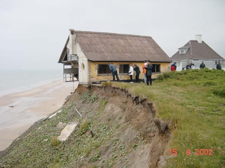
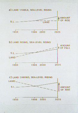
17
18

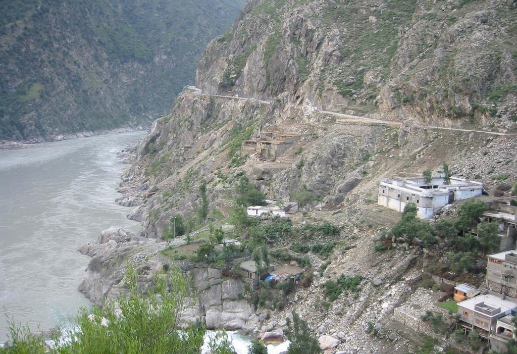
19
20
21 PERIGLACIAL HAZARDS Permafrost decay (thermokarst) Pingo/Palsa/Frost heave growth Thaw floods Glacier surges Ice Jams Debris flows Coast and river bank erosion Avalanches

22

23 The typical deformed moraine of a surging glacier
24 COASTAL HAZARDS Sea level change Dune decay and encroachment Bar formation Coast retreat Hurricane attack Salt marsh invasion Tsunami
25
26 HAZARDOUS HUNZA Glacier surges Enormous denudation Enormous siltation Glacier dams Mudflow dams Meltwater channel shifts Salt weathering Mudflow damage Rock falls Landslides Dust storms

27
28

29 Dammed lake sediments Landslide dam

30 Culvert Mudflow not water flow!

31 Culvert and boulder

32
33 DETERMINING RATES OF CHANGE Air photographs Remote sensing images Sequential maps Ground photographs Archival descriptions GPS and re-survey Hardware monitoring Sedimentation in swamps, lakes, bogs,etc. Archaeological sites

34
35 POST-EVENT ASSESSMENT Record nature of an event What damage was done to structures? What geomorphological change was achieved? What were the discharges involved (use of slackwater deposits)? Which areas were sensitive and which were not? Were there special processes operating?

36
37
38 POST-CONSTRUCTION ASSESSMENT Record nature and location of damage Record the situations where engineering solutions have proved to be right Record those situations where engineering solutions have proved to be wrong
39

40 Narrow beach Landslides The Cobb Monmouth Beach LYME REGIS, DORSET, UK

41
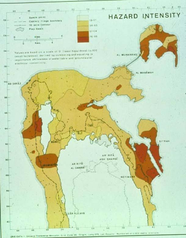
42 LYME REGIS Built on old landslide complex on Lias Clays Beach sediment not being replenished because of Holocene depletion and role of updrift landslide complexes Construction of harbour stops longshore drift and disrupts equilibrium shape Mining of beach materials Advice on solutions
43 EARTHQUAKE ZONING Artificial fills, unconsolidated materials, wet areas Karst Liquefaction prone areas Faults and Rock contrasts Mass movement zones Tsunami zones
44 NEOTECTONICS Deformation of river terraces & shorelines River course offsets Changes in river channel form Elevated coral reefs Displacement of man-made structures Dated sag ponds Changes recorded by GPS, tide gauges, repeat levelling, etc.
45 FLOOD PLAIN ZONING Geomorphological features: active channels, point bars, oxbows, levees, backswamps, splays Topographical surveys Old high flood levels: damage, historical records, lichens, cracked boulders, broken trees, trash, air photos Soil development Vegetation assemblages

46

47

48 Lab Simulation with Chalk
49 SALT HAZARD ASSESSMENT Where is the damage? What are the controls? Salinity, nature of salts, groundwater depth, nature of ground materials Lab. assessment of resistant materials Finding of resistant materials Sensitive areas zoning maps Other solutions
50 AGGRESSION Some salts are highly aggressive, especially salts that hydrate such as sodium sulphate, magnesium sulphate and sodium carbonate. These expand some 300% on hydration

51 Namibia pipeline

52 Sir Ronald Cooke Bahrain nurses home
53
54 MASS MOVEMENT PREDICTION Maps of previous landslide occurrence Maps of risk based on GIS and incorporating geology, relief, groundwater, vegetation, etc. Dating of past events (e.g. using dendro) Measurement of shear strength of materials to establish factor of safety etc.
55 LANDSCAPE INTERPRETATION The explanation of diverse and beautiful landscapes to the general public Nature trails Boards Interpretation centres Websites

56 Badlands 1.02 Bryce Canyon 1.75 Canyonlands 0.44 Capitol reef 0.65 Death valley 1.2 Grand Canyon 4.6 Yosemite 3.8 Arches 0.84 Zion 2.4 WESTERN USA ANNUAL VISITORS (millions)
57 GRAY on VALUING GEODIVERSITY Intrinsic or Existence value Cultural value to society (including spiritual value) Aesthetic value visual appeal Economic value (e.g. tourism, resources) Functional value in Earth Systems Educational and research value
 Geodiversity underpins biodiversity and its life-support system,")
58 GRAY (2004, p. 348) Geodiversity underpins biodiversity and its life-support system, therefore creating an inextricable link between the two.
59 LANDFORMS AS HABITAT Particular landforms are habitats, so that the protection of existing landforms or the reconstruction/reclamation of damaged landforms can be an important contribution to maintaining biodiversity Creation of new landscapes (e.g. quarries) that are in harmony with the geomorphological environment.
 Vegetation removal or afforestation Agriculture Recreation and tourism Military activity Future Climate change")
60 THREATS TO GEODIVERSITY Mineral extraction Landfill and quarry reclamation Land development and urban expansion Coastal erosion & protection River management (e.g. channelisation) Vegetation removal or afforestation Agriculture Recreation and tourism Military activity Future Climate change
61 GEOCONSERVATION UNESCO World Heritage Sites IUGS/UNESCO Global Geosites Geoparks US National Parks, National Natural Landmarks, National Wild & Scenic Rivers, State Parks, etc.


62 Current international initiatives to promote, protect and conserve geoheritage World Heritage of UNESCO UNESCO Geoparks ProGeo activity IAG Geomorphosites Working Group Special events, e.g. International Year of the Planet Earth
 Mount Sanqingshan, China (Granite landforms) New Caledonia (Reefs and lagoons) Surtsey, Iceland (Volcanic and coastal evolution) Phlegraean area, Italy (Sealevels) Hovsgol Lake, Mongolia")
63 Sites under review 2007/8 with a geomorphological component for which IAG reviewers have been suggested Pirin, Bulgaria (Glacial lakes, etc.) Mount Sanqingshan, China (Granite landforms) New Caledonia (Reefs and lagoons) Surtsey, Iceland (Volcanic and coastal evolution) Phlegraean area, Italy (Sealevels) Hovsgol Lake, Mongolia (Permafrost and lakes) Putorana Plateau, Russia (Basalt terrain) Glarus, Switzerland (Overthrust tectonics)


64 Should geomorphologists take a lead? What is missing on the World Heritage List (examples)? 1. Inselbergs and granite weathering features of Central Namibia 2. Paricutin volcano, Mexico 3. Wadi Rum sandstone terrain, Jordan 4. Gypsum karst, Ukraine 5. Limestone pavements, Burren, Ireland 6. Cockpit karst, Jamaica 7. Badlands, South Dakota, USA 8. Okavango inland delta, Botswana


65
66 GLOBAL CHANGE HOTSPOTS Severe changes predicted (e.g. High latitudes, High Plains of USA) Sensitivity because of fragility Sensitivity because of position (e.g. Bangladesh) Sensitivity because of thresholds (e.g. dune movement in High Plains of USA, coral bleaching, melting of permafrost)
67 Warming scenarios IPCC 2007

68 IT HAS ALL STARTED TO HAPPEN
69 GLACIER RETREAT Nisqually, NW USA)
70
71 HOT SPOTS Ice bodies sensitive to wave attack as ice shelves retreat Valley glaciers Permafrost negative mean annual temperatures Dunes at vegetation threshold Coral reefs in hot water 30 o C threshold Hurricane prone coasts 27 o C threshold

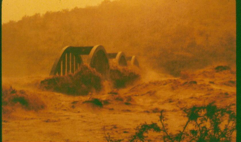
72 IPCC 2007


73 Amazonia Drought (2005) and potential forest die-back
74 AMAZONIA Of the 23 global climate models employed by the IPCC 2007, 50-70% predict a >20% reduction of dry-season rainfall in E. Amazonia, 40% in central Amazonia and 20% in the west (Malhi). The Hadley Centre model suggests that precipitation averaged across Amazonia could be reduced from c 1800 mm to 1100 mm by the 2040s.
75 AMAZONIA CONTINUED Soil moisture could re reduced by a temperature rise of c 3.3 degrees this century Forest removal by deforestation and increasing fires could lead to local climate effects due to changes in albedo, roughness of canopy surface, reduced moisture inputs to air from evapotranspiration, etc.

76 De Wit and Stankiewicz, Science, 2006.
77 PRECIPITATION CHANGE Overall global increase Some intensification of tropical circulation Northward displacement of sinking Hadley cell air Increase in UK winter rainfall and decrease in summer rainfall More moisture availability in cold regions Changes in rainfall intensity

78 STREAM RUNOFF In arid regions, an increase of temperature by c 2 degrees, and a reduction in precipitation of c 10% can lead to a discharge reduction of c 60 or more %.

79 Hadley Centre predictions of change in runoff by 2050
80 Sheffield and Wood, Climate Dynamics, 2008 Under the future projections, the models show decreases in soil moisture globally for all scenarios with a corresponding doubling of the spatial extent of severe soil moisture deficits and frequency of shortterm (4-6-month duration) droughts from the midtwentieth century to the end of the twenty-first. Longterm droughts become three times more common. Regionally, the Mediterranean, west African, central Asian and central American regions show large increases notably for long-term frequencies as do midlatitude North American regions.
81
82 A new Dust Bowl?

83 A black blizzard in the dirty thirties
84 DUNE REACTIVATION Holocene history of instability The lesson of the Dust Bowl Stores of available surfaces as result of past climates Critical nature of rainfall/vegetation threshold for wind action


85 The Mega-Kalahari Modelling by David Thomas suggests that from South Africa to Angola the whole Kalahari sandveld could be re-activated

86
87

88

89 AUSTRALIAN CYCLONES UNDER GREENHOUSE CONDITIONS

90 HURRICANES Sea water temperature threshold of 27 o C Increase in geographical spread? Increase in intensity? Increase in frequency? Warm water is not the only control of hurricane formation

91 HURRICANE EFFECTS Slope destabilisation Scouring of river channels Inputs of sediment into reefs and lagoons Raised sea level storm surges Increased wave attack on atolls, etc.
92

93

94 THE RHINE SHABALOVA ET AL The Rhine s discharge will become markedly more seasonal with mean discharge decreases of about 30% in summer, and increases by about 30 percent in winter by the end of the century The summer decrease is due to decrease in precipitation + increase in evapotranspiration The winter increase is caused by increased precipitation, reduced snow storage and increased early melt
 will migrate by some hundreds of metres.")
95 ALTITUDINAL SHIFT IN Lapse rates suggest that vegetation will shift c 180 m for every degree rise in temperature This implies that vegetation belts (and snowlines, etc.) will migrate by some hundreds of metres. VEGETATION
96
97

98

99

100

101
102 PERIGLACIAL AREAS Retreat of permafrost Thermokarst Removal of glue from slopes Erosion of shores and banks Deeper active layer debris flows, etc. Change in runoff seasonality Changes in groundwater recharge
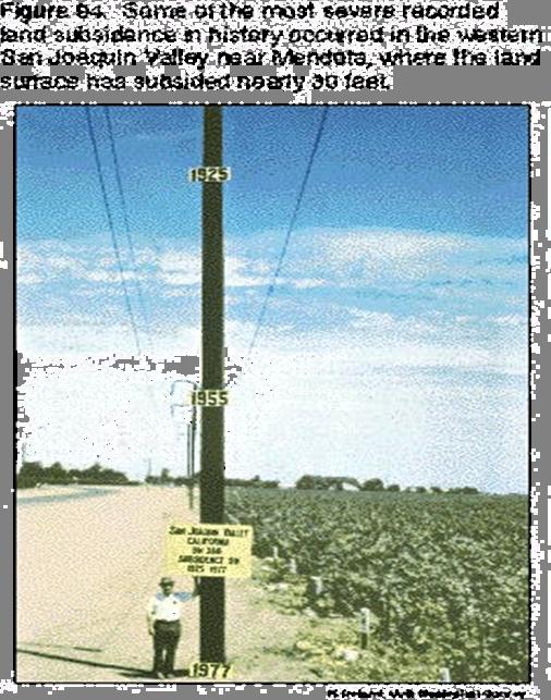
103 THERMOKARST LENA

104 Shishmaref, Alaska

105

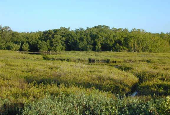
106
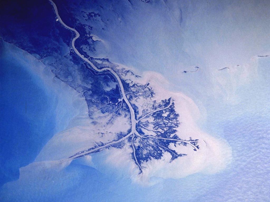
107 THE BIG ISSUE Ice sheets will be subjected to increased ablation (melting), the buoyancy effects of rising sea levels, the effects of ice shelf disappearance on wave attack, and the wasting effects of warmer oceans On the other hand, higher temperatures will lead to more snowfall and thus to higher rates of accumulation
108 GLACIERS Since Little Ice Age general retreat of c 20-70m per year Glaciers of European Alps have lost c 50% of their volume since the LIA Tidewater glaciers retreat especially quickly The Columbia glacier in Alaska retreated 13km between 1982 and 2000 East African glaciers occupy one third to one sixth of former area

109

110
111 SEA LEVEL RISE During the 20 th century the rate of rise averaged c mm per year During the 21 st century the rate of rise is likely to be c 5 mm per year
112

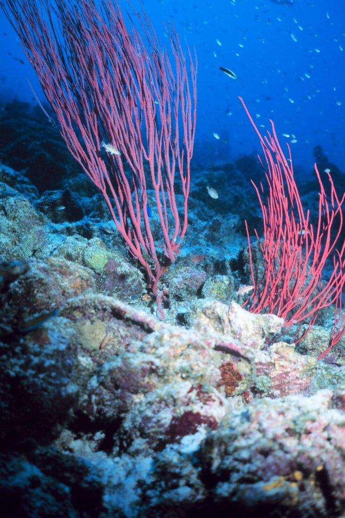
113

114 SUBSIDING AREAS Deltas, atolls Tectonic sinking Isostatic compensation Groundwater and hydrocarbon removal Compaction of organic sediments


115 Houston/Galveston Central valley, California
116
117 SENSITIVE COASTS Beaches Salt marshes Mangrove swamps Deltas Coral reefs Lagoons
118 MISSISSIPPI BIRDSFOOT
119 MISSISSIPPI BIRDSFOOT Subsidence Accelerating sea level rise Diversion of flow to other mouths Reduction in nourishment due to embankments Reduction of silt loads by cascades of dams

120 NILE DELTA An area of ongoing subsidence Sea-level rise Sediment starvation by Aswan and other dams Sensitivity of salt/fresh water interface

121

122 BANGLADESH AND THE GANGES/BRAMAPUTRA DELTA
123
124 CORAL REEFS Increase in sea surface temperatures will cause stress (bleaching) or stimulus Increase in storm frequency and intensity will build up islands, erode reefs, change species composition Increase in sea levels will stimulate reef growth (if slow), but will cause inundation (if fast) or if corals are stressed by siltation
125

126
127 SALT MARSH VULNERABILITY Less sensitive areas of high sediment input, areas of high tidal range (with high sediment transport potential), areas with effective organic accumulation More sensitive areas of subsidence, areas of low sediment input, slow growing mangroves, micro-tidal areas, reef settings (lack of allogenic sediment), constrained by sea walls
128 BRUUN RULE EROSION DEPOSITION About 100 m of erosion for 1 m rise in sea level on sandy beach

129 ACCELERATING COASTAL Sea level rise and the Bruun Rule Reduced beach nourishment because of dams Reduced beach nourishment because of defence structures Increasing storm activity? EROSION

130 SYNERGIES Permafrost degradation Coastal flooding Coastal erosion Coral reefs Moisture deficits and drying of lakes
131 GLOBAL WARMING AND HAZARDS Droughts and dunes and dust Hurricanes Permafrost degradation Ground subsidence Glacier retreat Sea-level rise Coast erosion
132 GEOMORPHOLOGICAL Monitor change RESEARCH Model future changes Identify vulnerable hot spots Consider mitigation strategies Consider feedbacks of geomorpholgical change
133
GLOBAL WARMING: GLOBAL WARMING. landscape implications. Andrew Goudie St Cross College Oxford
 GLOBAL WARMING: GLOBAL WARMING landscape implications Andrew Goudie St Cross College Oxford THE PROCESS OF CHANGE HAS STARTED IPCC 2007 Increased Glacier retreat since the early 1990s Area of seasonally
GLOBAL WARMING GLOBAL WARMING. Andrew Goudie St Cross College Oxford
 GLOBAL WARMING GLOBAL WARMING Andrew Goudie St Cross College Oxford OBJECTIONS If warming is taking place, it is due to solar activity Satellite observations do not show warming trend Only urban centres
Term Knowledge Using and applying Grade Criteria Autumn 1 Assessment window October Natural hazards pose major risks to people and property.
 Assessment Schedule Year 9 2015/6 Term Knowledge Using and applying Grade Criteria Autumn 1 Assessment window October 2015 3.1.1.2 Tectonic Natural hazards pose major risks to people and property. Definition
Geomorphology for Engineers
 Geomorphology for Engineers Edited by P. G. Fookes, E. M. Lee and G. Milligan Whittles Publishing CRC PRESS Contents Foreword Preface Dedication Biographies 1. Introduction to Engineering Geomorphology
The Coast: Beaches and Shoreline Processes
 1 2 3 4 5 6 7 8 9 The Coast: es and Shoreline Processes Trujillo & Thurman, Chapter 10 Oceanography 101 Chapter Objectives Recognize the various landforms characteristic of beaches and coastal regions.
EXTERNAL LAND FORMING PROCESSES
 NAME SCHOOL INDEX NUMBER DATE EXTERNAL LAND FORMING PROCESSES WEATHERING 1 1998 Q 7 (a) (i) What is the difference between weathering and mass wasting (ii) List five processes involved in chemical weathering
The Coast: Beaches and Shoreline Processes Trujillo & Thurman, Chapter 10
 The Coast: es and Shoreline Processes Trujillo & Thurman, Chapter 10 Oceanography 101 Chapter Objectives Recognize the various landforms characteristic of beaches and coastal regions. Identify seasonal
Geol 117 Lecture 18 Beaches & Coastlines. I. Types of Coastlines A. Definition:
 I. Types of Coastlines A. Definition: 1. Shore = narrow zone where ocean meets land (e.g. beach) 2. Coast is a broad area where both ocean and land processes act a. Includes onshore marshes, dunes, sea
Science EOG Review: Landforms
 Mathematician Science EOG Review: Landforms Vocabulary Definition Term canyon deep, large, V- shaped valley formed by a river over millions of years of erosion; sometimes called gorges (example: Linville
Physical Geography: Patterns, Processes, and Interactions, Grade 11, University/College Expectations
 Geographic Foundations: Space and Systems SSV.01 explain major theories of the origin and internal structure of the earth; Page 1 SSV.02 demonstrate an understanding of the principal features of the earth
water erosion lithosphere Describe the process of erosion and deposition. chemical weathering Dissolving limestone is an example of.
 At one time, there was one large island off the coast of Mississippi and now it is two separate islands. What caused the island to be split into two? water erosion The crust and the top part of the upper
Catastrophic Events Impact on Ecosystems
 Catastrophic Events Impact on Ecosystems Hurricanes Hurricanes An intense, rotating oceanic weather system with sustained winds of at least 74 mph and a welldefined eye Conditions for formation: Warm water
Weathering of Rocks. Weathering - Breakdown of rocks into pieces (sediment) 2 main types of weathering to rocks
 2 main types of weathering to rocks") Weathering of Rocks Weathering - Breakdown of rocks into pieces (sediment) 2 main types of weathering to rocks Mechanical weathering requires physical forces to break rocks into smaller pieces. Chemical
Weathering of Rocks Weathering - Breakdown of rocks into pieces (sediment) 2 main types of weathering to rocks Mechanical weathering requires physical forces to break rocks into smaller pieces. Chemical
Changes to Land 5.7B. landforms: features on the surface of Earth such as mountains, hills, dunes, oceans and rivers
 All the landforms on Earth have changed over time and continue to change. Many of the changes were caused by wind, moving water, and moving ice. Mountains have grown and shrunk. Rivers have cut away land
What are the different ways rocks can be weathered?
 Romano - 223 What are the different ways rocks can be weathered? Weathering - the breakdown of rocks and minerals at the Earth s surface 1. 2. PHYSICAL WEATHERING Rock is broken into smaller pieces with
Sea-level Rise on Cape Cod: How Vulnerable Are We? Rob Thieler U.S. Geological Survey Woods Hole, MA
 Sea-level Rise on Cape Cod: How Vulnerable Are We? Rob Thieler U.S. Geological Survey Woods Hole, MA Outline Sea-level and coastal processes Past sea-level change Predictions for the future Coastal responses
Think about the landforms where you live. How do you think they have changed over time? How do you think they will change in the future?
 reflect All the landforms on Earth have changed over time and continue to change. Many of the changes were caused by wind, moving water, and moving ice. Mountains have grown and shrunk. Rivers have cut
2/23/2009. Visualizing Earth Science. Chapter Overview. Deserts and Drylands. Glaciers and Ice Sheets
 Visualizing Earth Science By Z. Merali and B. F. Skinner Chapter 6 Deserts, Glaciers and Ice Sheets Chapter Overview Deserts and Drylands Glaciers and Ice Sheets Deserts Geography Categorization of deserts
2018 Geography Mock Examination
 2018 Geography Mock Examination Your Geography mock examination will test your understanding of Paper 1 (Living with the physical environment) and Section B (Fieldwork) from Paper 2. Attached are the necessary
Chapter 2 Planet Earth
 Chapter 2 Planet Earth Section Notes Earth and the Sun s Energy Water on Earth The Land Close-up The Water Cycle World Almanac Major Eruptions in the Ring of Fire Quick Facts Chapter 2 Visual Summary Video
Which map shows the stream drainage pattern that most likely formed on the surface of this volcano? A) B)
 B)") 1. When snow cover on the land melts, the water will most likely become surface runoff if the land surface is A) frozen B) porous C) grass covered D) unconsolidated gravel Base your answers to questions
1. When snow cover on the land melts, the water will most likely become surface runoff if the land surface is A) frozen B) porous C) grass covered D) unconsolidated gravel Base your answers to questions
Read Across America. Listen as I read for facts about Volcanoes. In the Shadow of the Volcano
 Read Across America Listen as I read for facts about Volcanoes. In the Shadow of the Volcano Constructive & Destructive Processes Earth s surface is always changing. Blowing wind and flowing water causes
CLIMATE READY BOSTON. Climate Projections Consensus ADAPTED FROM THE BOSTON RESEARCH ADVISORY GROUP REPORT MAY 2016
 CLIMATE READY BOSTON Sasaki Steering Committee Meeting, March 28 nd, 2016 Climate Projections Consensus ADAPTED FROM THE BOSTON RESEARCH ADVISORY GROUP REPORT MAY 2016 WHAT S IN STORE FOR BOSTON S CLIMATE?
EROSION AND DEPOSITION
 CHAPTER 8 EROSION AND DEPOSITION SECTION 8 1 Changing Earth s Surface (pages 252-255) This section explains how sediment is carried away and deposited elsewhere to wear down and build up Earth s surface.
Erosion and Deposition
 Erosion and Deposition Erosion Sediment natural forces move rock/soil from one place to another. gravity, water, wind, glaciers, waves are causes material moved by erosion Deposition when erosion lays
Cambridge Assessment International Education Cambridge International Advanced Subsidiary and Advanced Level. Published
 Cambridge Assessment International Education Cambridge International Advanced Subsidiary and Advanced Level GEOGRAPHY 9696/23 Paper 2 Advanced Physical Options MARK SCHEME Maximum Mark: 50 Published This
Chapter 2: Physical Geography
 Chapter 2: Physical Geography Pg. 39-68 Learning Goals for Chp2: q q q q q Explain how the Earth moves in space and why seasons change. Outline the factors that influence climate and recognize different
1. Erosion by Running Water Most powerful cause of erosion
 I. Destructive Forces Notes: Destructive force: a process in which land is destroyed or changed such as weathering and erosion. All landforms are a result of a combination of constructive and destructive
New GCSE Geography AQA
 Learning Checklist Half Term 1 26 th September 3 rd October 10 th October 17 th October 1.1.1 Tectonic Hazards Plate tectonics theory. Global distribution of earthquakes and volcanic eruptions and their
Constructive and Destructive Forces. Processes That Act Upon Earth s Surface Features
 Constructive and Destructive Forces Processes That Act Upon Earth s Surface Features What are Constructive and Destructive Forces? Constructive Force A constructive force is a process that raises or builds
Future Climate Change
 Future Climate Change How do you know whether to trust a prediction about the future? All predictions are based on global circulation models (GCMs, AOGCMs) - model accuracy is verified by its ability to
Spring break reading. Glacial formation. Surface processes: Glaciers and deserts. The Control of Nature
 suggested Spring break reading The Control of Nature by John McPhee Surface processes: Glaciers and deserts describes our efforts to control three natural hazards: 1. The Mississippi Floods 2. The Heimaey
Geography Class XI Fundamentals of Physical Geography Section A Total Periods : 140 Total Marks : 70. Periods Topic Subject Matter Geographical Skills
 Geography Class XI Fundamentals of Physical Geography Section A Total Periods : 140 Total Marks : 70 Sr. No. 01 Periods Topic Subject Matter Geographical Skills Nature and Scope Definition, nature, i)
Fukien Secondary School Monthly Vocabulary/Expression List for EMI Subjects Secondary Two. Subject: Geography
 Focus: General Specific : Section Two : Unit One 1 Landslide 2 Downslope movement 3 Rock 4 Soil 5 Gravity 6 Natural hazard 7 Rainwater 8 Friction 9 Hilly relief 10 Unstable 11 Season 12 Saturated 13 Construction
1/6/ th Grade Earth s Surface. Chapter 3: Erosion and Deposition. Lesson 1 (Mass Movement)
") Lesson 1 (Mass Movement) 7 th Grade Earth s Surface Chapter 3: Erosion and Deposition Weathering the chemical and physical processes that break down rock at Earth s surface Mechanical weathering when rock
Lesson 1 (Mass Movement) 7 th Grade Earth s Surface Chapter 3: Erosion and Deposition Weathering the chemical and physical processes that break down rock at Earth s surface Mechanical weathering when rock
This table connects the content provided by Education Perfect to the NSW Syllabus.
 Education Perfect Geography provides teachers with a wide range of quality, engaging and innovative content to drive positive student learning outcomes. Designed by teachers and written by our in-house
1. Which type of climate has the greatest amount of rock weathering caused by frost action? A) a wet climate in which temperatures remain below
 a wet climate in which temperatures remain below") 1. Which type of climate has the greatest amount of rock weathering caused by frost action? A) a wet climate in which temperatures remain below freezing B) a wet climate in which temperatures alternate
1. Which type of climate has the greatest amount of rock weathering caused by frost action? A) a wet climate in which temperatures remain below freezing B) a wet climate in which temperatures alternate
How does erosion happen?
 How does erosion happen? By National Geographic, adapted by Newsela staff on 10.03.17 Word Count 682 Level 830L These rock formations, in Bryce Canyon National Park, Utah, are called hoodoos. Although
Topic 6: Weathering, Erosion and Erosional-Deposition Systems (workbook p ) Workbook Chapter 4, 5 WEATHERING
 Workbook Chapter 4, 5 WEATHERING") Topic 6: Weathering, Erosion and Erosional-Deposition Systems (workbook p. 95-125) Workbook Chapter 4, 5 THE BIG PICTURE: Weathering, erosion and deposition are processes that cause changes to rock material
Topic 6: Weathering, Erosion and Erosional-Deposition Systems (workbook p. 95-125) Workbook Chapter 4, 5 THE BIG PICTURE: Weathering, erosion and deposition are processes that cause changes to rock material
East Penn School District Curriculum and Instruction
 East Penn School District Curriculum and Instruction Curriculum for: Geology of National Parks Course(s): Geology of the National Parks Grades: 10-12 Department: Science Length of Period (average minutes):
Activity 2.2: Recognizing Change (Observation vs. Inference)
") Activity 2.2: Recognizing Change (Observation vs. Inference) Teacher Notes: Evidence for Climate Change PowerPoint Slide 1 Slide 2 Introduction Image 1 (Namib Desert, Namibia) The sun is on the horizon
Activity 2.2: Recognizing Change (Observation vs. Inference) Teacher Notes: Evidence for Climate Change PowerPoint Slide 1 Slide 2 Introduction Image 1 (Namib Desert, Namibia) The sun is on the horizon
Debris flow: categories, characteristics, hazard assessment, mitigation measures. Hariklia D. SKILODIMOU, George D. BATHRELLOS
 Debris flow: categories, characteristics, hazard assessment, mitigation measures Hariklia D. SKILODIMOU, George D. BATHRELLOS Natural hazards: physical phenomena, active in geological time capable of producing
Fresh Water: Streams, Lakes Groundwater & Wetlands
 Fresh Water:, Lakes Groundwater & Wetlands Oct 27 Glaciers and Ice Ages Chp 13 Nov 3 Deserts and Wind and EXAM #3 Slope hydrologic cycle P = precip I = precip intercepted by veg ET = evapotranspiration
Landscape evolution. An Anthropic landscape is the landscape modified by humans for their activities and life
 Landforms Landscape evolution A Natural landscape is the original landscape that exists before it is acted upon by human culture. An Anthropic landscape is the landscape modified by humans for their activities
Surface Events & Landforms. Mrs. Green
 Surface Events & Landforms Mrs. Green Bell Work 1) Which event MOST likely causes the slowest change to the surface of Earth? a) Earthquake b) Landslide c) Volcano d) Wind 2) When cold weather freezes
Name. 4. The diagram below shows a soil profile formed in an area of granite bedrock. Four different soil horizons, A, B, C, and D, are shown.
 Name 1. In the cross section of the hill shown below, which rock units are probably most resistant to weathering? 4. The diagram below shows a soil profile formed in an area of granite bedrock. Four different
What is weathering and how does it change Earth s surface? Answer the question using
 7 th Grade Lesson What is weathering and how does it change Earth s surface? Answer the question using the sentence frame. You have 4 minutes. Weathering is. This changes the Earth s surface because. 1
Prentice Hall: Science Explorer, 16 Book Series 2005 Correlated to: Alabama Science Standards for Earth and Space Science Core (Grade 6)
") Alabama Science Standards for Earth and Space Science Core (Grade 6) 1. Identify global patterns of atmospheric movement, including El Niño, the Gulf Stream, the jet stream, the Coriolis effect, and global
Alabama Science Standards for Earth and Space Science Core (Grade 6) 1. Identify global patterns of atmospheric movement, including El Niño, the Gulf Stream, the jet stream, the Coriolis effect, and global
Name: Which rock layers appear to be most resistant to weathering? A) A, C, and E B) B and D
 A, C, and E B) B and D") Name: 1) The formation of soil is primarily the result of A) stream deposition and runoff B) precipitation and wind erosion C) stream erosion and mass movement D) weathering and biological activity 2)
Name: 1) The formation of soil is primarily the result of A) stream deposition and runoff B) precipitation and wind erosion C) stream erosion and mass movement D) weathering and biological activity 2)
mountain rivers fixed channel boundaries (bedrock banks and bed) high transport capacity low storage input output
 high transport capacity low storage input output") mountain rivers fixed channel boundaries (bedrock banks and bed) high transport capacity low storage input output strong interaction between streams & hillslopes Sediment Budgets for Mountain Rivers Little
mountain rivers fixed channel boundaries (bedrock banks and bed) high transport capacity low storage input output strong interaction between streams & hillslopes Sediment Budgets for Mountain Rivers Little
Tips for Success on a Test
 Number of Incorrect: Final Grade: Parent Signature: Top Tips for Success on a Test 1. Read the following statements at least two times. 2. Circle the key words in each question/ or statement. (*Remember
Chapter 2. Wearing Down Landforms: Rivers and Ice. Physical Weathering
 Chapter 2 Wearing Down Landforms: Rivers and Ice Physical Weathering Weathering vs. Erosion Weathering is the breakdown of rock and minerals. Erosion is a two fold process that starts with 1) breakdown
Lab 7: Sedimentary Structures
 Name: Lab 7: Sedimentary Structures Sedimentary rocks account for a negligibly small fraction of Earth s mass, yet they are commonly encountered because the processes that form them are ubiquitous in the
Chapter 1 Section 2. Land, Water, and Climate
 Chapter 1 Section 2 Land, Water, and Climate Vocabulary 1. Landforms- natural features of the Earth s land surface 2. Elevation- height above sea level 3. Relief- changes in height 4. Core- most inner
River Response. Sediment Water Wood. Confinement. Bank material. Channel morphology. Valley slope. Riparian vegetation.
 River Response River Response Sediment Water Wood Confinement Valley slope Channel morphology Bank material Flow obstructions Riparian vegetation climate catchment vegetation hydrological regime channel
Physical landscapes River landscapes in the UK
 Physical landscapes River landscapes in the UK The shape of river valleys change s as rivers flow downstream - PROCESSES Erosion Abrasion or corrasion Attrition Hydraulic Action Solution or corrosion Deposition
GEOG 1010A. Come to the PASS workshop with your mock exam complete. During the workshop you can work with other students to review your work.
 It is most beneficial to you to write this mock midterm UNDER EXAM CONDITIONS. This means: Complete the midterm in 1.5 hours. Work on your own. Keep your notes and textbook closed. Attempt every question.
Soil erosion susceptibility and coastal evolution: examples in southern New Caledonia
 Pacific Island Countries GIS /RS User Conference Soil erosion susceptibility and coastal evolution: examples in southern New Caledonia Pascal DUMAS et Olivier COHEN University of New-Caledonia (EA 4242/
For the multiple-choice questions, completely fill in the circle alongside the appropriate answer.
 DRAFT SPECIMEN MATERIAL A-level GEOGRAPHY Paper 1 Physical geography Specimen Question Paper Time allowed: 2 hours 30 minutes Materials For this paper you must have: a pencil a rubber a ruler. You may
What is a landform? These shapes (except for bodies of water) on the earth s surface are all examples of landforms.
 on the earth s surface are all examples of landforms.") Landforms What is a landform? These shapes (except for bodies of water) on the earth s surface are all examples of landforms. archipelago a large group of many islands. The Hawaiian Islands Lighthouse
Landforms What is a landform? These shapes (except for bodies of water) on the earth s surface are all examples of landforms. archipelago a large group of many islands. The Hawaiian Islands Lighthouse
 Page 1 of 9 Name: Base your answer to the question on the diagram below. The arrows show the direction in which sediment is being transported along the shoreline. A barrier beach has formed, creating a
Preliminaries to Erosion: Weathering and Mass Wasting
 Preliminaries to Erosion: Weathering & Mass Wasting All things deteriorate in time. Virgil 1 Preliminaries to Erosion: Weathering and Mass Wasting Denudation The Impact of Weathering and Mass Wasting on
OIKOS > landslide > mechanism >predisposing causes
 predisposing causes and trigger OIKOS > landslide > mechanism >predisposing causes Landslides are events that occur in space and time. As such, it is usually possible to identify both one or more landslide
3/3/2013. The hydro cycle water returns from the sea. All "toilet to tap." Introduction to Environmental Geology, 5e
 Introduction to Environmental Geology, 5e Running Water: summary in haiku form Edward A. Keller Chapter 9 Rivers and Flooding Lecture Presentation prepared by X. Mara Chen, Salisbury University The hydro
TEACHER BACKGROUND KNOWLEDGE. Surface Processes: Weathering and Erosion
 TEACHER BACKGROUND KNOWLEDGE Surface Processes: Weathering and Erosion Core Concepts Precipitation (caused by the water cycle) and wind cause rocks to be broken into smaller pieces in the process called
Weathering and Erosion
 Weathering and Erosion OBJECTIVE: Explain how erosion and deposition shape Earth s surface by matching and using models How do erosion and deposition shape Earth s surface? Deposition Formation Transported
Chapter 3 Erosion and Deposition. The Big Question:
 Chapter 3 Erosion and Deposition The Big Question: 1 Design a way to represent and describe the 4 types of mass movement. You may use pictures, diagrams, list, web, chart, etc 2 Chapter 3: Erosion and
Erosion and Deposition
 Erosion and Deposition Chapter Test A Multiple Choice Write the letter of the correct answer on the line at the left. 1. Water erosion begins when runoff from rainfall flows in a thin layer over the land
Changing Earth s Surface
 Name Date Class Changing Earth s Surface What processes wear down and build up Earth s surface? What causes the different types of mass movement? Erosion is the process by which natural forces move weathered
Reading Material. See class website. Sediments, from Oceanography M.G. Gross, Prentice-Hall
 Reading Material See class website Sediments, from Oceanography M.G. Gross, Prentice-Hall Materials filling ocean basins Dissolved chemicals especially from rivers and mid-ocean ridges (volcanic eruptions)
Ice Sheets and Sea Level -- Concerns at the Coast (Teachers Guide)
") Ice Sheets and Sea Level -- Concerns at the Coast (Teachers Guide) Roughly 153 million Americans (~53% of the US population) live in coastal counties. World wide some 3 billion people live within 200 km
Ice Sheets and Sea Level -- Concerns at the Coast (Teachers Guide) Roughly 153 million Americans (~53% of the US population) live in coastal counties. World wide some 3 billion people live within 200 km
A physical feature of the Earth s surface
 Earth s Landforms A physical feature of the Earth s surface A physical feature of the Earth s surface LANDFORM Highest of Earth s physical features Highest of Earth s physical features MOUNTAIN Low area
The Agents of Erosion
 The Agents of Erosion 1. Erosion & Deposition 2. Water 3. Wind 4. Ice California Science Project 1 1. Erosion and Deposition Erosion is the physical removal and transport of material by mobile agents such
Name: Class: Date: Multiple Choice Identify the letter of the choice that best completes the statement or answers the question.
 Name: Class: Date: geology ch 7 test 2008 Multiple Choice Identify the letter of the choice that best completes the statement or answers the question. 1. Which of the following is true about ice sheets?
EARTH S CHANGING SURFACE
 EARTH S CHANGING SURFACE Weathering Together, weathering and erosion work continuously to wear down the material on Earth s surface. weathering process that breaks down rock and other substances of Earth
b Blackwell Science Environmental Geology PRINCIPLES AND PRACTICE
 Environmental Geology PRINCIPLES AND PRACTICE Fred G. Bell Department of Geology and Applied Geology University of Natal, Durban, South Africa b Blackwell Science Preface, ix 1 Introduction, 1 1.1 Planning
CHAPTER 6 & 7 VOCABULARY
 CHAPTER 6 & 7 VOCABULARY 1. Biome 2. Climate 3. Latitude 4. Altitude 5. Emergent layer 6. Epiphyte 7. Understory 8. Permafrost 9. Wetland 10.Plankton 11.Nekton 12.Benthos 13.Littoral zone 14.Benthic zone
Rising Sea Levels: Time for Proactive Action in Florida and the Caribbean?
 Rising Sea Levels: Time for Proactive Action in Florida and the Caribbean? Dr. Alan Fyall and Dr. Thomas Wahl National Center for Integrated Coastal Research, University of Central Florida Dr. Roberta
Science 8 Unit 1 Test Review Analyze factors that affect productivity and species distribution in marine and fresh water environments.
 Science 8 Unit 1 Test Review How does water shape our world? 1. Define a water system in your own words 2. What is water important for? (3 things at least) 3. What is water made of? Water in our world
Time allowed: 1 hour 30 minutes
 SPECIMEN ASSESSMENT MATERIAL: SET 2 GCSE GEOGRAPHY Paper 1 Living with the physical environment Specimen Materials For this paper you must have: a pencil a ruler. Time allowed: 1 hour 30 minutes Instructions
Erosion and Deposition
 CHAPTER 3 LESSON 2 Erosion and Deposition Landforms Shaped by Water and Wind Key Concepts What are the stages of stream development? How do water erosion and deposition change Earth s surface? How do wind
10/27/2014. Surface Processes. Surface Processes. Surface Processes. Surface Processes. Surface Processes
 Hewitt/Lyons/Suchocki/Yeh Conceptual Integrated Science Chapter 25 Surface or surficial processes originate at Earth's surface and reshape its contours. Surface processes include: Weathering Erosion Deposition
(version 3) I. HumAN -Environment Interaction
 I. HumAN -Environment Interaction") (version 3) I. HumAN -Environment Interaction A. Landforms 1. Earth s topography is made up of many different types of landforms. 2. While the planet is covered primarily with water, the four major types
(version 3) I. HumAN -Environment Interaction A. Landforms 1. Earth s topography is made up of many different types of landforms. 2. While the planet is covered primarily with water, the four major types
Hard Engineering: Lyme Regis
 Hard Engineering: Lyme Regis By The British Geographer Situation Lyme Regis, with a population of 4400 is located in the centre of the Heritage Jurassic Coast in Dorset, South England. It is exposed to
Physical Geography A Living Planet
 Physical Geography A Living Planet The geography and structure of the earth are continually being changed by internal forces, like plate tectonics, and external forces, like the weather. Iguaçu Falls at
Bell Ringer. Are soil and dirt the same material? In your explanation be sure to talk about plants.
 Bell Ringer Are soil and dirt the same material? In your explanation be sure to talk about plants. 5.3 Mass Movements Triggers of Mass Movements The transfer of rock and soil downslope due to gravity is
every continent has an extensive dry region! " deserts are as much as 1/3 of Earth s surface!
 deserts! deserts! every continent has an extensive dry region! " deserts are as much as 1/3 of Earth s surface! Hollywood portrayal of vast stretches of sand dune! " Sahara has only 10% covered by sand!
Floods Lecture #21 20
 Floods 20 Lecture #21 What Is a Flood? Def: high discharge event along a river! Due to heavy rain or snow-melt During a flood, a river:! Erodes channel o Deeper & wider! Overflows channel o Deposits sediment
Weathering and Soil Formation. Chapter 10
 Weathering and Soil Formation Chapter 10 Old and New Mountains The Appalachian Mountains appear very different from the Sierra Mountains. The Appalachians are smaller, rounded, gently sloping, and covered
Unit 3 Study Guide -- Greenberg science, 6C
 Unit 3 Study Guide -- Greenberg science, 6C Name Pd. Date / / 2018 + +5 extra credit points on the test if submitted complete and correct ON THE TEST DATE. + A copy can be found on my website mgreenberg.weebly.com
8UNIT. External dynamics of the Earth. What do you remember? Key language. Content objectives
 8UNIT External dynamics of the Earth What do you remember? Can you name the solids in the photograph? nd the liquid? Is the liquid moving? How does it move? What is the name of this formation of water?
PALEOGEOGRAPHY of NYS. Definitions GEOLOGIC PROCESSES. Faulting. Folding 9/6/2012. TOPOGRAPHIC RELIEF MAP of NYS GRADATIONAL TECTONIC
 TOPOGRAPHIC RELIEF MAP of NYS PALEOGEOGRAPHY of NYS Prof. Anthony Grande AFG 2012 Definitions GEOLOGIC PROCESSES Geography: study of people living on the surface of the earth. Geology: the scientific study
M14/3/GEOGR/SP2/ENG/TZ0/XX/Q GEOGRAPHY STANDARD LEVEL PAPER 2. Monday 19 May 2014 (morning) 1 hour 20 minutes INSTRUCTIONS TO CANDIDATES
 1 hour 20 minutes INSTRUCTIONS TO CANDIDATES") M14/3/GEOGR/SP2/ENG/TZ0/XX/Q 22145203 GEOGRAPHY STANDARD LEVEL PAPER 2 Monday 19 May 2014 (morning) 1 hour 20 minutes INSTRUCTIONS TO CANDIDATES Do not open this examination paper until instructed to do
M14/3/GEOGR/SP2/ENG/TZ0/XX/Q 22145203 GEOGRAPHY STANDARD LEVEL PAPER 2 Monday 19 May 2014 (morning) 1 hour 20 minutes INSTRUCTIONS TO CANDIDATES Do not open this examination paper until instructed to do
Scenarios for the NI coast in the 21 st Century
 Scenarios for the NI coast in the 21 st Century Prof Julian Orford Geography, Archaeology & Palaeoecology Queen s University, Belfast Challenging perspective Living by the coast is good for your health!
NATURAL HAZARDS PROFILE OF JAMAICA RAFI AHMAD
 NATURAL HAZARDS PROFILE OF JAMAICA RAFI AHMAD rafi.ahmad@uwimona.edu.jm UNIT FOR DISASTER STUDIES DEPARTMENT OF GEOGRAPHY AND GEOLOGY Tel. 1-876-927-2728/2129 Fax: 1-876-977-6029 THE UNIVERSITY OF THE
Fundamentals of THE PHYSICAL ENVIRONMENT. David Briggs, Peter Smithson, Kenneth Addison and Ken Atkinson
 Fundamentals of THE PHYSICAL ENVIRONMENT Second Edition David Briggs, Peter Smithson, Kenneth Addison and Ken Atkinson LONDON AND NEW YORK Contents L,ISI Of colour piates List of black and white plates
UNIT 4: Earth Science Chapter 21: Earth s Changing Surface (pages )
") CORNELL NOTES Directions: You must create a minimum of 5 questions in this column per page (average). Use these to study your notes and prepare for tests and quizzes. Notes will be turned in to your teacher
CORNELL NOTES Directions: You must create a minimum of 5 questions in this column per page (average). Use these to study your notes and prepare for tests and quizzes. Notes will be turned in to your teacher
Weathering/ Erosion/ Deposition in the Texas Ecoregions
 Practice Test Study these answers Weathering/ Erosion/ Deposition in the Texas Ecoregions 1. In the Texas Panhandle, physical weathering by abrasion is usually caused by wind, water and gravity 2. Two
Conceptual Understandings for K-2 Teachers
 AFK12SE/NGSS Strand Disciplinary Core Ideas ESS1: Earth s Place in the Universe What is the universe, and what is Earth s place in it? ESS1. A: The Universe and Its Stars What is the universe, and what
What is a landform? These shapes (except for bodies of water) on the earth s surface are all examples of landforms.
 on the earth s surface are all examples of landforms.") Landforms What is a landform? These shapes (except for bodies of water) on the earth s surface are all examples of landforms. archipelago a large group of many islands. The Hawaiian Islands Lighthouse
Landforms What is a landform? These shapes (except for bodies of water) on the earth s surface are all examples of landforms. archipelago a large group of many islands. The Hawaiian Islands Lighthouse