This presentation includes vital contributions from:
|
|
|
- Chester Nelson
- 6 years ago
- Views:
Transcription

1 Fossil Creek, Arizona Childs-Irving Decommissioning, Fish Restoration, Research & Monitoring Charlie Schlinger, College of Engineering & Natural Sciences, Northern Arizona University (NAU)

2 This presentation includes vital contributions from: Pool below Fossil Springs Grant Loomis Tonto N.F. Rob Clarkson USBR Phil Smithers APS Mark Fallon APS Dave Weedman AGFD Bill Auberle, Martha Lee, Michele James, Abe Springer, Jane Marks, Rod Parnell all of NAU NAU undergraduate and graduate students


3 363 km mi 2 View on Road from Strawberry down to Irving Photo by Dave Lamkin Illustration by Lorrie Yazzie

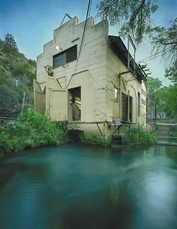


4 Childs-Irving Decommissioning Irving Generating Station, Photo courtesy of APS / Nick Berezenko


5
 11,000' Steel Flume on Wooden Trestle 10,000' Concrete Flume 10 Pipe Bridges (2460') 7 Tunnels (9000') 17,200' Penstock and Siphon pipe 2 concrete diversion dams 3 earthen")
6 Childs-Irving Hydroelectric Project Childs 2.8 MW (2 Units) Irving 1.4 MW (1 Unit) 11,000' Steel Flume on Wooden Trestle 10,000' Concrete Flume 10 Pipe Bridges (2460') 7 Tunnels (9000') 17,200' Penstock and Siphon pipe 2 concrete diversion dams 3 earthen dams (at Stehr Lake) 42 cfs flow powers each site Since 1909: Removed most of the baseflow from14 miles of Fossil Creek
7 Re-licensing & Settlement Agreement 1992: APS began FERC re-licensing process 1998: FERC is prepared to issue license; APS began discussions with interveners 9/2001: historic Settlement Agreement Signatories include: Center for Biological Diversity American Rivers Yavapai-Apache Nation N. AZ Audubon Society AZ Riparian Council Nature Conservancy AZ Chapter

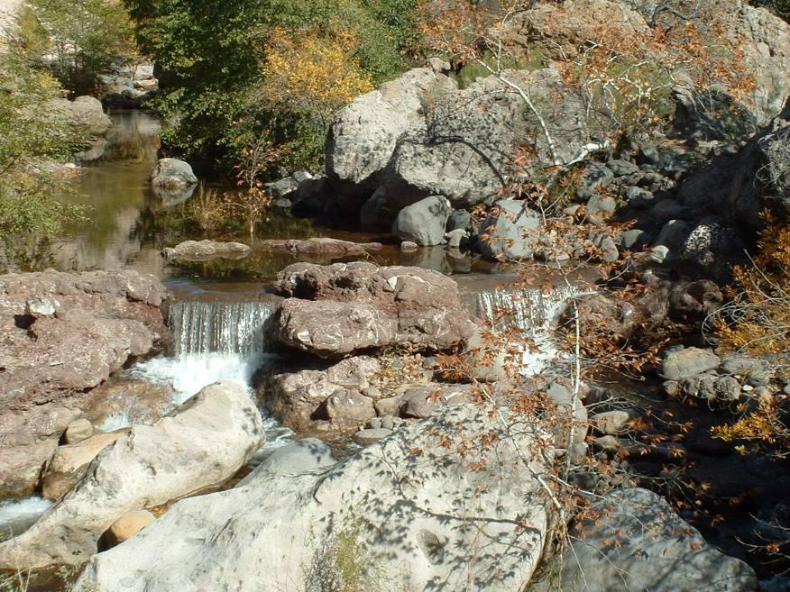
8 Why is APS Decommissioning? This is a unique opportunity to return the baseflow to 14 miles of stream channel, and re-establish a vibrant riparian corridor of which we have all too few in Arizona. Fossil Creek deposits travertine and once flows are restored it will again be the 4 th largest such system in North America.
9 Presently October 2004: FERC approval of APS License Surrender, after completing NEPA, Historic Preservation, etc., processes March 24, 2005: FERC approval of decommissioning construction documents Return of flows to Fossil Creek on or before May 20 th Decommissioning: Spring


10 Fossil Creek, with a few cfs, and with the full 46 cfs baseflow (Photographs provided by APS)

11 Native Fish Restoration Purpose Gila River basin native fishes are critically imperiled Decommissioning and the return of baseflow to Fossil Creek presented a unique recovery opportunity for native fish Spikedace, Meda fulgida Photo by Dean Foster

12 Fish Barrier Fish barrier was required to inhibit re-invasion Challenges: protect Wilderness and Wild and Scenic values limited use of mechanized equipment no road access Construction: Fall 2004
13


14 Fish Renovation (Build Barrier) Salvage existing native species Remove non-natives w/chemical application Restock salvaged native species Monitor before and after flow restoration


15 Exotic fishes Green sunfish J. Humphrey FWS Longfin dace M. Jakle Smallmouth bass Steinhart Desert sucker S. Hedwall Sonoran sucker I. Reed Native fishes


16 Crew electrofishing to capture native fish Drip buckets for applying piscicide to the main channel


17 Special Status Species Lowland Leopard Frog Jim Rorabaugh USFWS Yellow-Billed Cuckoo Troy Corman AGFD Common Black Hawk Arthur Morris

18 NAU s Research and Monitoring 6 principal areas: Travertine development Aquatic species and interactions with travertine Sediment, stream morphology and hydrology Springs characterization Recreation impacts and visitor use Coordination, education, outreach

19 Travertine Research Objectives: Examine rates of travertine deposition Quantify recovery of travertine dams in the stream reach below the Fossil Springs Diversion Dam Investigate the role of algae and leaf litter in travertine formation


20 Havasu Creek Little Colorado R. Fossil Creek Fossil Creek travertine, Photo courtesy of APS / Nick Berezenko
21 Streamflow Gaging Rationale Ecosystems, recreation, fish restoration, and travertine recovery depend critically on Fossil Springs baseflow Objectives Identify gaging location(s) & method(s) Facilitate agreements for long-term O&M Install one or more gages in Fossil Creek Monitor springflow, research hydrology
 60.00 50.00 40.00 30.")
22 Recent USFS Streamflow Data Fossil Creek Flows ( ) Median Monthly Flow & 46.0 cfs Mean Annual Flow Stream Flow (cfs) Jan Feb Mar Apr May Jun Jul Aug Sep Oct Nov Dec Month

23 Sediment Research & Monitoring FERC stipulated dam lowering of14-ft Investigate how sediment presently behind the dam moves downstream in response to floods Establish the baseline: 2005 Periodically monitor: 2006? Stream channel morphology headwaters to confluence with Verde River

24 Recreation and Visitor Impacts Visitor Survey Demographics Preferred means of communication Responses to proposed management strategies Activities & experiences Monitoring Camping Impacts Continuation of a USFS effort Mapping & condition monitoring Research: Identify strategies for successful implementation of a Recreation Management Plan Fossil Springs Photo courtesy of APS / Nick Berezenko


25 Uncontrollable Crowd Bill Auberle NAU Childs Hot Springs Roy Aikins AGFD Other Signage Rory Aikins AGFD Riparian Campsite Matt Jedra NAU
26 Aquatic Species, Food Webs & Ecosystem Processes What are the current distributions of native and exotic species and how will they change with restoration? How will increased travertine deposition affect primary and secondary productivity and nutrient cycling? How has water diversion and exotic species affected native fish and invertebrate feeding patterns; will flow restoration and exotic fish removal revive native food webs?
27 Springs Research & Monitoring Discharge Locate and survey spring orifices Nearly 100 individual orifices < 1 gpm to > 5 cfs Surveyed locations permit monitoring at individual orifices Chemistry Elevated Helium concentrations in certain springs suggestive of a deep origin for gases There is a mantle-derived Helium component in spring water possibly associated with magmatic CO 2

28 Research & Monitoring Coordination Research & Monitoring Inventory web-based Who, how, what, when, where and why State of the Watershed Report Due out in 2 nd Quarter 2005 web-based Facilitate Communication

29 For More Information: Contact: Michele James Project Coordinator
REDWOOD VALLEY SUBAREA
 Independent Science Review Panel Conceptual Model of Watershed Hydrology, Surface Water and Groundwater Interactions and Stream Ecology for the Russian River Watershed Appendices A-1 APPENDIX A A-2 REDWOOD
THE STATE OF SURFACE WATER GAUGING IN THE NAVAJO NATION
 THE STATE OF SURFACE WATER GAUGING IN THE NAVAJO NATION Aregai Tecle Professor of Hydrology Northern Arizona University Flagstaff, AZ Acknowledgement Many thanks to my research team mates and Elisabeth
Opportunity for Spill Management on the Dolores River in 2017: A Collaboration of 'Spill Science. Dolores River Downstream of McPhee Reservoir
 Opportunity for Spill Management on the Dolores River in 2017: A Collaboration of 'Spill Science Dolores River Downstream of McPhee Reservoir Opportunity for Spill Management on the Dolores River in 2017:
3.0 TECHNICAL FEASIBILITY
 3.0 TECHNICAL FEASIBILITY 3.1 INTRODUCTION To enable seasonal storage and release of water from Lake Wenatchee, an impoundment structure would need to be constructed on the lake outlet channel. The structure
Lower Tuolumne River Accretion (La Grange to Modesto) Estimated daily flows ( ) for the Operations Model Don Pedro Project Relicensing
 Estimated daily flows ( ) for the Operations Model Don Pedro Project Relicensing") Lower Tuolumne River Accretion (La Grange to Modesto) Estimated daily flows (1970-2010) for the Operations Model Don Pedro Project Relicensing 1.0 Objective Using available data, develop a daily time series
Lower Tuolumne River Accretion (La Grange to Modesto) Estimated daily flows (1970-2010) for the Operations Model Don Pedro Project Relicensing 1.0 Objective Using available data, develop a daily time series
GAMINGRE 8/1/ of 7
 FYE 09/30/92 JULY 92 0.00 254,550.00 0.00 0 0 0 0 0 0 0 0 0 254,550.00 0.00 0.00 0.00 0.00 254,550.00 AUG 10,616,710.31 5,299.95 845,656.83 84,565.68 61,084.86 23,480.82 339,734.73 135,893.89 67,946.95
Gravel Transport Study Report for Energy Northwest's Packwood Lake Hydroelectric Project FERC No Lewis County, Washington
 Final Gravel Transport Study Report for Energy Northwest's Packwood Lake Hydroelectric Project FERC No. 2244 Lewis County, Washington Submitted to P.O. Box 968 Richland, Washington 99352-0968 Submitted
PRELIMINARY DRAFT FOR DISCUSSION PURPOSES
 Memorandum To: David Thompson From: John Haapala CC: Dan McDonald Bob Montgomery Date: February 24, 2003 File #: 1003551 Re: Lake Wenatchee Historic Water Levels, Operation Model, and Flood Operation This
Fire effects on tinajas and amphibian habitat at Saguaro National Park
 Fire effects on tinajas and amphibian habitat at Saguaro National Park Don Swann, Kara O Brien, and Chuck Perger Saguaro National Park, Tucson, Arizona Thanks to: Mike Sredl (Arizona Game and Fish) Ann
Attachment B to Technical Memorandum No.2. Operations Plan of Ross Valley Detention Basins
 Attachment B to Technical Memorandum No.2 Operations Plan of Ross Valley Detention Basins Operations Plan of Ross Valley Detention Basins Stetson Engineers Inc. January 26, 2011 1.0 Introduction Achieving
Disentangling Impacts of Climate & Land Use Changes on the Quantity & Quality of River Flows in Southern Ontario
 Disentangling Impacts of Climate & Land Use Changes on the Quantity & Quality of River Flows in Southern Ontario by Trevor Dickinson & Ramesh Rudra, Water Resources Engineering University of Guelph Acknowledgements
Illinois State Water Survey Division
 Illinois State Water Survey Division SURFACE WATER SECTION SWS Miscellaneous Publication 108 SEDIMENT YIELD AND ACCUMULATION IN THE LOWER CACHE RIVER by Misganaw Demissie Champaign, Illinois June 1989
Folsom Dam Water Control Manual Update Joint Federal Project, Folsom Dam
 Folsom Dam Water Control Manual Update Joint Federal Project, Folsom Dam Public Workshop May 25, 2016 Sacramento Library Galleria 828 I Street, Sacramento, CA US Army Corps of Engineers BUILDING STRONG
Climate Change and Water Supply Research. Drought Response Workshop October 8, 2013
 Climate Change and Water Supply Research Drought Response Workshop October 8, 2013 DWR Photo Oroville Reservoir, 2009 Talk Overview Expectations History Atmospheric Rivers and Water Supply Current Research
Algae and Dissolved Oxygen Dynamics of Landa Lake and the Upper Spring Run
 Algae and Dissolved Oxygen Dynamics of Landa Lake and the Upper Spring Run Why study algae and dissolved oxygen dynamics of Landa Lake and the Upper Spring Run? During low-flow conditions, extensive algal
CR AAO Bridge. Dead River Flood & Natural Channel Design. Mitch Koetje Water Resources Division UP District
 CR AAO Bridge Dead River Flood & Natural Channel Design Mitch Koetje Water Resources Division UP District Old County Road AAO Bridge Map courtesy of Marquette County Silver Lake Basin McClure Basin
2015 Fall Conditions Report
 2015 Fall Conditions Report Prepared by: Hydrologic Forecast Centre Date: December 21 st, 2015 Table of Contents Table of Figures... ii EXECUTIVE SUMMARY... 1 BACKGROUND... 2 SUMMER AND FALL PRECIPITATION...
ZUMWALT WEATHER AND CLIMATE ANNUAL REPORT ( )
") ZUMWALT WEATHER AND CLIMATE ANNUAL REPORT (26-29) FINAL DRAFT (9 AUGUST 21) J.D. HANSEN 1, R.V. TAYLOR 2, AND V.S. JANSEN 3 INTRODUCTION The Zumwalt Prairie in northeastern Oregon is a unique grassland
ZUMWALT WEATHER AND CLIMATE ANNUAL REPORT (26-29) FINAL DRAFT (9 AUGUST 21) J.D. HANSEN 1, R.V. TAYLOR 2, AND V.S. JANSEN 3 INTRODUCTION The Zumwalt Prairie in northeastern Oregon is a unique grassland
Changing Hydrology under a Changing Climate for a Coastal Plain Watershed
 Changing Hydrology under a Changing Climate for a Coastal Plain Watershed David Bosch USDA-ARS, Tifton, GA Jeff Arnold ARS Temple, TX and Peter Allen Baylor University, TX SEWRU Objectives 1. Project changes
Squaw Creek. General Information
 General Information is a tributary to the Salmon River. It enters the north side of the river about 0 miles downstream of North Fork, Idaho. The study reach is about a 30 ft length of stream about 2 miles
Unconventional Wisdom and the Effects of Dams on Downstream Coarse Sediment Supply. Byron Amerson, Jay Stallman, John Wooster, and Derek Booth
 Unconventional Wisdom and the Effects of Dams on Downstream Coarse Sediment Supply 3 February 2009 Byron Amerson, Jay Stallman, John Wooster, and Derek Booth Sultan River, WA OBJECTIVE Consider the landscape
HYDROLOGIC AND WATER RESOURCES EVALUATIONS FOR SG. LUI WATERSHED
 HYDROLOGIC AND WATER RESOURCES EVALUATIONS FOR SG. LUI WATERSHED 1.0 Introduction The Sg. Lui watershed is the upper part of Langat River Basin, in the state of Selangor which located approximately 20
January 22, Coronado National Forest 300 West Congress Street Tucson, AZ Jim Upchurch, Forest Supervisor. Dear Mr.
 January 22, 2015 Coronado National Forest 300 West Congress Street Tucson, AZ 85701 Attn: Jim Upchurch, Forest Supervisor Dear Mr. Upchurch: In your letter dated January 16, 2015, you requested that Hudbay
Chiang Rai Province CC Threat overview AAS1109 Mekong ARCC
 Chiang Rai Province CC Threat overview AAS1109 Mekong ARCC This threat overview relies on projections of future climate change in the Mekong Basin for the period 2045-2069 compared to a baseline of 1980-2005.
Restoration Goals TFG Meeting. Agenda
 San Joaquin River Restoration Program Restoration Goals TFG Meeting Reach 2B Update April 28, 2010 Agenda 1. Introductions 2. Program Restoration Goal Context 3. Program Update a) Interim Flows b) EIS/EIR
Webinar and Weekly Summary February 15th, 2011
 Webinar and Weekly Summary February 15th, 2011 -Assessment of current water conditions - Precipitation Forecast - Recommendations for Drought Monitor Upper Colorado Normal Precipitation Upper Colorado
WHEN IS IT EVER GOING TO RAIN? Table of Average Annual Rainfall and Rainfall For Selected Arizona Cities
 WHEN IS IT EVER GOING TO RAIN? Table of Average Annual Rainfall and 2001-2002 Rainfall For Selected Arizona Cities Phoenix Tucson Flagstaff Avg. 2001-2002 Avg. 2001-2002 Avg. 2001-2002 October 0.7 0.0
II. Resource benefits. Å. Native Fish
 Discussion Points for a Sediment-Triggered BHBF Test in WY07, New Information and Need for Reconsideration and Recommendation to the Secretary of the Interior 11/30/07 FINAL Proposed AMWG motion for Dec.
The Climate of Oregon Climate Zone 4 Northern Cascades
 /05 E55 Unbound issue No. 9/ is Does not circulate Special Report 916 May 1993 The Climate of Oregon Climate Zone 4 Property of OREGON STATE UNIVERSITY Library Serials Corvallis, OR 97331-4503 Agricultural
Implementing a Project with 319 Funds: The Spring Brook Meander Project. Leslie A. Berns
 Implementing a Project with 319 Funds: The Spring Brook Meander Project Leslie A. Berns "...to acquire... and hold lands... for the purpose of protecting and preserving the flora, fauna and scenic beauties...
In the Matter of Emergency Regulation of the Level of
 INTERNATIONAL JOINT COMMISSION In the Matter of Emergency Regulation of the Level of Rainy Lake and of other Boundary Waters in the Rainy Lake Watershed. Supplementary Order to the Order Prescribing Method
N 2 3. Lake Huron. St. Clair River. Black River Assessment. Figure 1. Major tributaries to the Black River. 1. Berry Drain 2. Elk Creek.
 1. Berry Drain 2. Elk Creek Deckerville 3. Arnot Creek 4. Black Creek 5. Silver Creek 6. Plum Creek 7. Mill Creek 1 Sandusky Carsonville 8. Stocks Creek Applegate N 2 3 Croswell Peck 0 5 10 Brown City
60 PERCENT DESIGN REPORT HABITAT RESTORATION OF THE CHELAN RIVER REACH 4 AND TAILRACE
 60 PERCENT DESIGN REPORT HABITAT RESTORATION OF THE CHELAN RIVER REACH 4 AND TAILRACE Prepared for Public Utility District Number 1 of Chelan County 327 North Wenatchee Avenue Wenatchee, Washington 98801
Water Temperature Monitoring of the Klamath River Mainstem
 Water Temperature Monitoring of the Klamath River Mainstem Progress Report #3 Prepared by Robert Rohde and Leaf Hillman with assistance provided by Susan Smith and William Tripp Karuk Tribe of California
Simulating the groundwater discharge to wetlands. Mukwonago Basin Example and Potential Application in Dane County
 Simulating the groundwater discharge to wetlands Mukwonago Basin Example and Potential Application in Dane County Conceptual Model Topography is major control on flow to wetlands Land Surface Water Table
Jackson County 2013 Weather Data
 Jackson County 2013 Weather Data 61 Years of Weather Data Recorded at the UF/IFAS Marianna North Florida Research and Education Center Doug Mayo Jackson County Extension Director 1952-2008 Rainfall Data
MARMOT CREEK BASIN: MANAGING FORESTS FOR WATER
 MARMOT CREEK BASIN: MANAGING FORESTS FOR WATER CABIN AND TWIN CREEK EXPERIMENTS 1962-1987 MARMOT CREEK SUBBASINS Subbasin Drainage Treatment Area (ha) (completion date) Cabin Creek 212 (50%)* Commercial
Modeling the Effects of Climate and Land Cover Change in the Stoney Brook Subbasin of the St. Louis River Watershed
 Modeling the Effects of Climate and Land Cover Change in the Stoney Brook Subbasin of the St. Louis River Watershed Joe Johnson and Jesse Pruette 214 NASA Research Internship Geospatial Technologies Program
Memo. I. Executive Summary. II. ALERT Data Source. III. General System-Wide Reporting Summary. Date: January 26, 2009 To: From: Subject:
 Memo Date: January 26, 2009 To: From: Subject: Kevin Stewart Markus Ritsch 2010 Annual Legacy ALERT Data Analysis Summary Report I. Executive Summary The Urban Drainage and Flood Control District (District)
A Post Processing Tool to Assess Sediment and Nutrient Source Allocations from SWAT Simulations
 A Post Processing Tool to Assess Sediment and Nutrient Source Allocations from SWAT Simulations Michael Van Liew William Puknat Montana Department of Environmental Quality Helena, Montana, USA PROBLEM:
Streamflow, Sediment, and Nutrient Simulation of the Bitterroot Watershed using SWAT
 Streamflow, Sediment, and Nutrient Simulation of the Bitterroot Watershed using SWAT by Dr. Michael Van Liew Montana Department of Environmental Quality Helena, Montana, USA Site Map of SWAT Watersheds
Folsom Dam Water Control Manual Update Joint Federal Project, Folsom Dam
 Folsom Dam Water Control Manual Update Joint Federal Project, Folsom Dam Public Workshop May 28, 2015 Library Galleria 828 I Street, Sacramento, CA US Army Corps of Engineers BUILDING STRONG WELCOME &
NRC Workshop Probabilistic Flood Hazard Assessment (PFHA) Jan 29-31, Mel Schaefer Ph.D. P.E. MGS Engineering Consultants, Inc.
 Jan 29-31, Mel Schaefer Ph.D. P.E. MGS Engineering Consultants, Inc.") Stochastic Event Flood Model (SEFM) Stochastic Modeling of Extreme Floods A Hydrological Tool for Analysis of Extreme Floods Mel Schaefer Ph.D. P.E. MGS Engineering Consultants, Inc. Olympia, WA NRC Workshop
Stochastic Event Flood Model (SEFM) Stochastic Modeling of Extreme Floods A Hydrological Tool for Analysis of Extreme Floods Mel Schaefer Ph.D. P.E. MGS Engineering Consultants, Inc. Olympia, WA NRC Workshop
NORTHUMBERLAND COUNTY, PA
 QUAKER RUN Stream and Wetland Restoration As-Built Completion Report and First Year Monitoring Data Coal Township NORTHUMBERLAND COUNTY, PA Upstream Before Upstream After Prepared for: COAL TOWNSHIP 805
Field Observations and One-Dimensional Flow Modeling of Summit Creek in Mack Park, Smithfield, Utah
 Intermountain Center for River Rehabilitation and Restoration, Utah State University 31 July 2018 Field Observations and One-Dimensional Flow Modeling of Summit Creek in Mack Park, Smithfield, Utah I.
YUBA COUNTY WATER AGENCY
 YUBA COUNTY WATER AGENCY Representative Site Selection Above Englebright Reservoir Stream Fish, Aquatic BMI, Aquatic Mollusks Yuba County Water Agency Yuba River Development Project FERC Project No. 2246
Stream Discharge and the Water Budget
 Regents Earth Science Unit 6: Water Cycle & Climate Name: Lab # Stream Discharge and the Water Budget Introduction: The United States Geological Survey (USGS) measures and publishes values for the daily
Snowcover interaction with climate, topography & vegetation in mountain catchments
 Snowcover interaction with climate, topography & vegetation in mountain catchments DANNY MARKS Northwest Watershed Research Center USDA-Agricultural Agricultural Research Service Boise, Idaho USA RCEW
FORECAST-BASED OPERATIONS AT FOLSOM DAM AND LAKE
 FORECAST-BASED OPERATIONS AT FOLSOM DAM AND LAKE 255 237 237 237 217 217 217 200 200 200 0 163 131 Bridging the Gap163Conference 255 0 132 255 0 163 122 The Dana on Mission Bay San Diego, CA January 28,
WOLF CREEK GARRARD DITCH DIVESION GRINNELL DITCH DIVERSION ON WOLF CREEK
 WOLF CREEK GARRARD DITCH DIVESION GRINNELL DITCH DIVERSION ON WOLF CREEK WOLF CREEK DRAINAGE INTRODUCTION BIG PICTURE Wolf Creek flows out of the east slope of the Bighorn Mountains, between the tributaries
A Review of the 2007 Water Year in Colorado
 A Review of the 2007 Water Year in Colorado Nolan Doesken Colorado Climate Center, CSU Mike Gillespie Snow Survey Division, USDA, NRCS Presented at the 28 th Annual AGU Hydrology Days, March 26, 2008,
National Integrated Drought Information System. Southeast US Pilot for Apalachicola- Flint-Chattahoochee River Basin 20-March-2012
 National Integrated Drought Information System Southeast US Pilot for Apalachicola- Flint-Chattahoochee River Basin 20-March-2012 Current drought status from Drought Monitor http://www.drought.unl.edu/dm/monitor.html
2. PHYSICAL SETTING FINAL GROUNDWATER MANAGEMENT PLAN. 2.1 Topography. 2.2 Climate
 FINAL GROUNDWATER MANAGEMENT PLAN 2. PHYSICAL SETTING Lassen County is a topographically diverse area at the confluence of the Cascade Range, Modoc Plateau, Sierra Nevada and Basin and Range geologic provinces.
Case Study 2: Twenty-mile Creek Rock Fords
 Case Study : Twenty-mile Creek Rock Fords Location Crossing Description Washington. Okanagan National Forest. Methow Valley Ranger District. Chewuch river basin, East Chewuch Road. The Twenty-mile Creek
Water Management for Environmental Restoration Flows In the Big Bend reach, Rio Grande Rio Bravo
 University of California, Davis Department of Land, Air and Water Resources Water Management for Environmental Restoration Flows In the Big Bend reach, Rio Grande Rio Bravo 46 th Annual Meeting 8 9 March,
Climate also has a large influence on how local ecosystems have evolved and how we interact with them.
 The Mississippi River in a Changing Climate By Paul Lehman, P.Eng., General Manager Mississippi Valley Conservation (This article originally appeared in the Mississippi Lakes Association s 212 Mississippi
Ontonagon River Assessment FIGURES
 FIGURES 95 Major Streams and Lakes 1 Pelton Creek 36 Imp Creek 2 Slate River 37 Imp Lake 3 Marshall Creek 38 Marion Lake 4 Trout Brook 39 Tamarack Lake 5 Lake Gogebic 40 Tamarack River 6 West Branch Ontonagon
CoCoRaHS Monitoring Colorado s s Water Resources through Community Collaborations
 CoCoRaHS Monitoring Colorado s s Water Resources through Community Collaborations Nolan Doesken Colorado Climate Center Atmospheric Science Department Colorado State University Presented at Sustaining
Integrating Weather Forecasts into Folsom Reservoir Operations
 Integrating Weather Forecasts into Folsom Reservoir Operations California Extreme Precipitation Symposium September 6, 2016 Brad Moore, PE US Army Corps of Engineers Biography Brad Moore is a Lead Civil
Missouri River Basin Water Management
 Missouri River Basin Water Management US Army Corps of Engineers Missouri River Navigator s Meeting February 12, 2014 Bill Doan, P.E. Missouri River Basin Water Management US Army Corps of Engineers BUILDING
PROJECT TITLE: 4.50 MW AKKIHEBBAL MINI HYDEL SCHEME, CAUVERY HYDRO ENERGY LTD., INDIA
 PROJECT TITLE: 4.50 MW AKKIHEBBAL MINI HYDEL SCHEME, CAUVERY HYDRO ENERGY LTD., INDIA Document Prepared By: Cauvery Hydro Energy Limited Contact Information Cauvery Hydro Energy Limited 67, Lavina Courts,
Lake Winnebago Regulation Meeting
 Lake Winnebago Regulation Meeting USACE Detroit District October 9, 2014 US Army Corps of Engineers Agenda Basin Overview Major Stakeholders Maintenance a and Repair Work Weather Conditions 2013-20142014
Columbia Estuary Province
 Rolling Provincial Review: Implementation 2001-2004 Province 73 Columbia Basin Fish & Wildlife Authority Province FY 2001-2004 Spending Summaries NPCC Recommendations and BPA Spending by Project Category,
2001 ANNUAL REPORT on INTERBASIN TRANSFERS for RTP South and the Towns of Cary, Apex, and Morrisville
 2001 ANNUAL REPORT on INTERBASIN TRANSFERS for RTP South and the Towns of Cary, Apex, and Morrisville Prepared for: Town of Cary Town of Apex Town of Morrisville RTP South/Wake County Submitted to: North
Riverine Modeling Proof of Concept
 Technical Team Meeting Riverine Modeling Proof of Concept Version 2 HEC-RAS Open-water Flow Routing Model April 15-17, 2014 Prepared by R2 Resource Consultants, Brailey Hydrologic, Geovera, Tetra Tech,
San Francisco Public Utilities Commission Hydrological Conditions Report For April 2014
 San Francisco Public Utilities Commission Hydrological Conditions Report For April 2014 J. Chester, C. Graham, A. Mazurkiewicz, & M. Tsang, May 13, 2014 Snow in the High Country The view from Bond Pass
AN ASSESSMENT OF THE RELATIONSHIP BETWEEN RAINFALL AND LAKE VICTORIA LEVELS IN UGANDA
 AN ASSESSMENT OF THE RELATIONSHIP BETWEEN RAINFALL AND LAKE VICTORIA LEVELS IN UGANDA BY CATHERINE MULINDE BA (Environmental Management), PGD (Meteorology) Teaching Assistant Department of Geography, Meteorology
Assessment. Assessment
 2001 SPRINGBROOK CREEK RESTORATION - THREE YEAR POST-CONSTRUCTION REVIEW - Presented by Bruce Henderson and Andy Harris 2005 River Restoration Northwest Symposium Skamania Lodge, Washington www.hendersonlandservices.com
Fenhe (Fen He) Map of River. Table of Basic Data. China 10
 Map of River. Table of Basic Data. China 10") Fenhe (Fen He) Map of River Table of Basic Data Name(s): Fenhe (in Huanghe River) Location: Shanxi Province, Northern China Area: 39,471 km 2 Origin: Mt. Guancen (2,147 m) Outlet: Huanghe Serial No. :
Fenhe (Fen He) Map of River Table of Basic Data Name(s): Fenhe (in Huanghe River) Location: Shanxi Province, Northern China Area: 39,471 km 2 Origin: Mt. Guancen (2,147 m) Outlet: Huanghe Serial No. :
Hydrologic Conditions in the Delaware River Basin
 2017 Hydrologic Conditions in the Delaware River Basin Prepared by Operations Staff June 2018 Hydrologic Highlights Hydrologic Conditions in the Delaware River Basin Annual Report 2017 At the start of
Birch Creek Geomorphic Assessment and Action Plan
 Birch Creek Geomorphic Assessment and Action Plan Jim Webster Tim Hanrahan, PhD, CFM Jesse Schwartz, PhD Zach Hill January 22, 2015 White Eagle Grange This Project is a First Step in Strategy Planning
Highlights of the 2006 Water Year in Colorado
 Highlights of the 2006 Water Year in Colorado Nolan Doesken, State Climatologist Atmospheric Science Department Colorado State University http://ccc.atmos.colostate.edu Presented to 61 st Annual Meeting
Jackson County 2018 Weather Data 67 Years of Weather Data Recorded at the UF/IFAS Marianna North Florida Research and Education Center
 Jackson County 2018 Weather Data 67 Years of Weather Data Recorded at the UF/IFAS Marianna North Florida Research and Education Center Doug Mayo Jackson County Extension Director 1952-2008 Rainfall Data
Diagnostic Geomorphic Methods for Understanding Future Behavior of Lake Superior Streams What Have We Learned in Two Decades?
 Diagnostic Geomorphic Methods for Understanding Future Behavior of Lake Superior Streams What Have We Learned in Two Decades? Faith Fitzpatrick USGS WI Water Science Center, Middleton, WI fafitzpa@usgs.gov
Lower South Fork McKenzie River Floodplain Enhancement Project
 Lower South Fork McKenzie River Floodplain Enhancement Project McKenzie River Ranger District Willamette National Forest Project Location The project is located in the South Fork McKenzie River Watershed,
How Do Human Impacts and Geomorphological Responses Vary with Spatial Scale in the Streams and Rivers of the Illinois Basin?
 How Do Human Impacts and Geomorphological Responses Vary with Spatial Scale in the Streams and Rivers of the Illinois Basin? Bruce Rhoads Department of Geography University of Illinois at Urbana-Champaign
Stream Geomorphology. Leslie A. Morrissey UVM July 25, 2012
 Stream Geomorphology Leslie A. Morrissey UVM July 25, 2012 What Functions do Healthy Streams Provide? Flood mitigation Water supply Water quality Sediment storage and transport Habitat Recreation Transportation
Hydrologic Monitoring Station Information Summary. December Brannon J. Ketcham Hydrologist
 Hydrologic Monitoring Station Information Summary December 1998 Brannon J. Ketcham Hydrologist National Park Service Coho and Steelhead Restoration Project Point Reyes National Seashore Introduction Hydrologic
A High Elevation Climate Monitoring Network
 A High Elevation Climate Monitoring Network Kelly T. Redmond Western Regional Climate Center Desert Research Institute Reno Nevada AGU San Francisco WRCC / OSU Nevada Precip-Elevation Distribution 100%
Hydrologic Conditions in the Delaware River Basin
 Hydrologic Conditions in the Delaware River Basin April : Flooding in Lambertville, New Jersey Aerial photo used with permission of www.elevated-images.com Annual Report Prepared by Operations Staff June
Strategies for managing sediment in dams. Iwona Conlan Consultant to IKMP, MRCS
 Strategies for managing sediment in dams Iwona Conlan Consultant to IKMP, MRCS 1 Sediment trapping by dams Active storage capacity Dead storage coarse material (bed load) Fine materials (suspension) Francis
Merced Irrigation District Hydrologic and Hydraulic Operations (MIDH2O) Model
 Model") Merced Irrigation District Hydrologic and Hydraulic Operations (MIDH2O) Model September 05, 2018 Marco Bell, Merced Irrigation District Bibek Joshi, Dewberry Objective Introduce HEC-RTS Benefits of MIDH2O
Merced Irrigation District Hydrologic and Hydraulic Operations (MIDH2O) Model September 05, 2018 Marco Bell, Merced Irrigation District Bibek Joshi, Dewberry Objective Introduce HEC-RTS Benefits of MIDH2O
Albeni Falls Operations Meeting 2015
 Albeni Falls Operations Meeting 2015 Katherine Rowden NWS Joel Fenolio Corps of Engineers Agenda Introductions Drought-Weather Conditions Free flow operations Review of Clarified Operations Albeni Falls
Remaining Capacity in Great Lakes Reservoirs
 US Army Corps of Engineers Detroit District Remaining Capacity in Great Lakes Reservoirs Storage Capacity Behind Great Lakes Dams Field Data and Modeling Motivation for project Project overview Data and
Conceptual Model of Stream Flow Processes for the Russian River Watershed. Chris Farrar
 Conceptual Model of Stream Flow Processes for the Russian River Watershed Chris Farrar Several features of creeks affect the interactions between surface and groundwater. This conceptual model uses the
Evaluation of Geomorphic Effects of Removal of Marmot and Little Sandy Dams and Potential Impacts on Anadromous Salmonids
 PRELIMINARY FINAL Evaluation of Geomorphic Effects of Removal of Marmot and Little Sandy Dams and Potential Impacts on Anadromous Salmonids Prepared for: Portland General Electric 121 SW Salmon Street
Sedimentation in the Nile River
 Advanced Training Workshop on Reservoir Sedimentation Sedimentation in the Nile River Prof. Dr. Abdalla Abdelsalam Ahmed 10-16 Oct. 2007, IRTCES, Beijing, China CWR,Sudan 1 Water is essential for mankind
Black Gore Creek 2013 Sediment Source Monitoring and TMDL Sediment Budget
 Black Gore Creek 2013 Sediment Source Monitoring and TMDL Sediment Budget Prepared for: Prepared By: - I. Introduction The Black Gore Creek Total Maximum Daily Load (TMDL) was developed in collaboration
Monitoring of Stream Flows and Playa Run-on in Dixie Valley for Water Years 2009, 2010 and 2011
 Monitoring of Stream Flows and Playa Run-on in Dixie Valley for Water Years 2009, 2010 and 2011 Prepared by: Interflow Hydrology, Inc., Truckee, CA & Mahannah & Associates, LLC, Reno, NV 1 Monitoring of
National Integrated Drought Information System Southeast US Pilot for Apalachicola- Flint-Chattahoochee River Basin. 22 May 2012
 National Integrated Drought Information System Southeast US Pilot for Apalachicola- Flint-Chattahoochee River Basin 22 May 2012 Outline Welcome Keith Ingram, UF, Southeast Climate Consortium Current drought
APPLICATIONS OF DOWNSCALING: HYDROLOGY AND WATER RESOURCES EXAMPLES
 APPLICATIONS OF DOWNSCALING: HYDROLOGY AND WATER RESOURCES EXAMPLES Dennis P. Lettenmaier Department of Civil and Environmental Engineering For presentation at Workshop on Regional Climate Research NCAR
Tracking the Climate Of Northern Colorado Nolan Doesken State Climatologist Colorado Climate Center Colorado State University
 Tracking the Climate Of Northern Colorado Nolan Doesken State Climatologist Colorado Climate Center Colorado State University Northern Colorado Business Innovations November 20, 2013 Loveland, Colorado
Climate Change Impact Assessment on Long Term Water Budget for Maitland Catchment in Southern Ontario
 215 SWAT CONFERENCE, PURDUE Climate Change Impact Assessment on Long Term Water Budget for Maitland Catchment in Southern Ontario By Vinod Chilkoti Aakash Bagchi Tirupati Bolisetti Ram Balachandar Contents
Solutions to Flooding on Pescadero Creek Road
 Hydrology Hydraulics Geomorphology Design Field Services Photo courtesy Half Moon Bay Review Solutions to Flooding on Pescadero Creek Road Prepared for: San Mateo County Resource Conservation District
Plasticity of Pleuraphis jamesii across a monsoon gradient: A field trial at the Canyonlands Research Center
 Plasticity of Pleuraphis jamesii across a monsoon gradient: A field trial at the Canyonlands Research Center Dave Hoover 1, Troy Wood 2 and Mike Duniway 1 1 US Geological Survey, Southwest Biological Science
Storm Report: January 27, 2008 Maricopa County, AZ
 Storm Report: January 27, 2008 Maricopa County, AZ Engineering Division, Flood Warning Branch TABLE OF CONTENTS Meteorology...2 Precipitation...4 Runoff...9 ALERT System Alarms...12 TABLES Table 1 Summary
2 Groundwater Basin Monitoring
 Zone 7 Water Agency 2 Groundwater Basin Monitoring Programs 2.1 Climatological Monitoring 2 Groundwater Basin Monitoring Programs This section describes Zone 7's Climatological Monitoring Program which
Appendix E Plots from the Evaluation of the CNRFC Operational Hydrologic Model
 Appendix E Plots from the Evaluation of the CNRFC Operational Hydrologic Model APE-1 2 Trinity Lake Inflow 2 1 Simulated 1 1 1 2 2 Observed Figure APE-1. Simulated daily flow versus observed (FNF) flow
Water Supply Conditions and Outlook June 4, 2018
 Water Supply Conditions and Outlook June 4, 2018 Flow Forecasting & Operations Planning Water Security Agency Overview Water supply conditions across Saskatchewan are generally good with most reservoir
Why Geomorphology for Fish Passage
 Channel Morphology - Stream Crossing Interactions An Overview Michael Love Michael Love & Associates mlove@h2odesigns.com (707) 476-8938 Why Geomorphology for Fish Passage 1. Understand the Scale of the