University of Leeds 3GP Geophysics Field Trip Lake Balaton, Hungary
|
|
|
- Christian Cross
- 6 years ago
- Views:
Transcription
1 University of Leeds 3GP Geophysics Field Trip Lake Balaton, Hungary September 1-15, 2007 geological background and logistics Staff: Greg Houseman, Graham Stuart
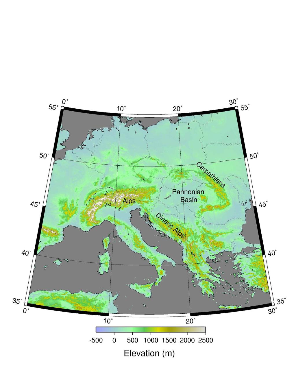
2 The Alpine-Carpathian-Pannonian System Elevation (m)

3 Bohemian Massif The Pannonian Basin TransDanubian Range Vienna Basin Carpathian Mts Alps Transylvanian Basin Lake Balaton Pennines (Italy) Adriatic Sea Dinaric Alps Great Hungarian Plane cover photo from: Cloetingh,S., F.Horvath, G. Bada, and A. Lankreijer Neotectonic and Surface processes: The Pannonian Basin and Alpine/Carpathian System

4 The Pannonian is an extensional Basin covered in recent sediments. In Hungary the TransDanubian Range exposes the oldest sedimentary rocks Pliocene Quaternary Late Miocene Early to mid Miocene Paleogene Paleo Mesozoic Figure from a document by Horvath, 2003

5 Post Mid-Miocene (younger than 10 Ma) sediments The Bakony Highland is part of the TransDanubian Figure from Sacchi and Horvath, 2003

6 Tertiary-Quaternary structures: shortening is indicated across the Carpathians; extension and strike-slip inside the Pannonian Figure from Wenzel et al., 2003

7 Lithospheric Thickness Map from: Atlas of the Geodynamics of the Pannonian Basin (Horvath, Bada et al.) 100 km 60 km 80 km

8 Conceptual models for the Development of the Pannonian Alpine-Carpathian system was one continuous fold belt until mid-miocene Carpathian started to move out and overthrust East European platform Crust and lithosphere were thinned, lithosphere more so. Figure from Huismans et al., 2003

9 Present day seismicity in the Pannonian. Database includes > 20,000 historical and instrumentally recorded earthquakes. Figure from Toth et al., 2003

10 Seismic tomography shows unusually slow (or hot) upper mantle beneath the Pannonian Basin, and unusually fast (or cold) material in the transition zone beneath. Major seismicity is found in a narrow cold structure beneath the eastern Carpathians (Vrancea) Figure: Wortel and Spakman (2000)

11 Sketch of the Gravitational Instability in 3D

 Topography")


12 Rectangular initial crustal thickness perturbation Surface topography (m) Moho topography (km) Topography of lithosphere base (km) (km above initial lithosphere base) t=11 Myr Downwelling develops faster along the long edge of the rectangular region. Figure: Gemmer and Houseman (2006)
 sensors loaned by SEIS-UK, NERC Geophysical Equipment")
13 CBP-HST: High-Resolution Seismic Tomography Array (April 06 July 07) CBP-RBB: Regional Broadband Array (Sept 05 Oct 07) sensors loaned by SEIS-UK, NERC Geophysical Equipment Facility

14 Ages of Volcanic Activity in the Pannonian Volcanism (calc-alkaline) started at about 20 Ma and has continued throughout. Increasing alkaline volcanism indicates a lithospheric source region for magma.

15 Theoretical stratigraphic column along north side of Lake Balaton Pannonian silts, sands and gravels unconformably overlie mid-miocene sediments, punctuated by basalts. The major unconformity between upper Triassic reef and mid-miocene sediments represents the Alpine orogeny. Paleozoic sediments are found beneath the Triassic Figure from Geological Map of Lake Balaton
16 Natural Thermal Springs in Hungary Figure from Lenkey et al., 2003
17 Possible Geophysical Targets in Balaton Region Miocene stratigraphy and structure of sediments in particular: Depth to basement unconformities, structure Normal, Thrust and Strike-slip structures are all present from the multi-phase tectonic history (extension followed by convergence) Ground water - including thermal springs
18 Measurement Techniques Seismic: Reflection / Refraction (marine and land) High Resolution Reflection Seismic Gravity Magnetics Total Field / vertical Gradient Electrical VLF (induction) Resistivity Tomography Radar Surveying Techniques, including EDM, and GPS
19 Logistical Arrangements Refer the 2007 Geophysical Field School Handbook for details regarding arrangements for: Travel Accommodation Food Work groups Reports Safety
NATURAL ENVIRONMENT. Geophysics
 NATURAL ENVIRONMENT Geophysics Geodynamics Alpine, Carpathian and Dinaric mountain belts surround the Pannonian (Carpathian) Basin, of Neogene through Quaternary in age. The Cenozoic evolution of the Alpine-Pannonian
SOEE3250/5675/5115 Inverse Theory Lecture 10; notes by G. Houseman
 SOEE3250/5675/5115 Inverse Theory Lecture 10; notes by G. Houseman Travel-time tomography Examples of regional lithospheric tomography CBP / SCP projects data acquisition: array / sources arrival time
DEEP SEISMIC SOUNDING ACROSS THE VRANCEA REGION
 International Symposium on Strong Vrancea Earthquakes and Risk Mitigation Oct. 4-6, 2007, Bucharest, Romania DEEP SEISMIC SOUNDING ACROSS THE VRANCEA REGION V. Raileanu 1, F. Hauser 2, 4, A. Bala 1, W.
Copyright McGraw-Hill Education. All rights reserved. No reproduction or distribution without the prior written consent of McGraw-Hill Education
 Copyright McGraw-Hill Education. All rights reserved. No reproduction or distribution without the prior written consent of McGraw-Hill Education Tibetan Plateau and Himalaya -southern Asia 11.00.a VE 10X
Global Tectonics. Kearey, Philip. Table of Contents ISBN-13: Historical perspective. 2. The interior of the Earth.
 Global Tectonics Kearey, Philip ISBN-13: 9781405107778 Table of Contents Preface. Acknowledgments. 1. Historical perspective. 1.1 Continental drift. 1.2 Sea floor spreading and the birth of plate tectonics.
Overview of the Seismic Source Characterization for the Palo Verde Nuclear Generating Station
 Overview of the Seismic Source Characterization for the Palo Verde Nuclear Generating Station Scott Lindvall SSC TI Team Lead Palo Verde SSC SSHAC Level 3 Project Tuesday, March 19, 2013 1 Questions from
Earthquakes. Earthquakes are caused by a sudden release of energy
 Earthquakes Earthquakes are caused by a sudden release of energy The amount of energy released determines the magnitude of the earthquake Seismic waves carry the energy away from its origin Fig. 18.1 Origin
Earth Systems Science Chapter 7. Earth Systems Science Chapter 7 11/11/2010. Seismology: study of earthquakes and related phenomena
 Earth Systems Science Chapter 7 I. Structure of the Earth II. Plate Tectonics The solid part of the earth system includes processes, just like the atmosphere and oceans. However, the time scales for processes
Lithospheric Structure of an ancient Extensional Basin within a Convergent Orogen: the Curnamona block and Flinders Ranges of South Australia.
 Lithospheric Structure of an ancient Extensional Basin within a Convergent Orogen: the Curnamona block and Flinders Ranges of South Australia. Summary Lithosphere-mantle interaction in the continental
Mountains are then built by deforming crust: Deformation & Mountain Building. Mountains form where stresses are high!
 Deformation & Mountain Building Where are mountains located? Deformation and Folding Mountain building Mountains form where stresses are high! Mountains form at all three types of plate boundaries where
Plate Tectonics. entirely rock both and rock
 Plate Tectonics I. Tectonics A. Tectonic Forces are forces generated from within Earth causing rock to become. B. 1. The study of the origin and arrangement of Earth surface including mountain belts, continents,
Questions and Topics
 Plate Tectonics and Continental Drift Questions and Topics 1. What are the theories of Plate Tectonics and Continental Drift? 2. What is the evidence that Continents move? 3. What are the forces that
(This is a sample cover image for this issue. The actual cover is not yet available at this time.)
") (This is a sample cover image for this issue. The actual cover is not yet available at this time.) This article appeared in a journal published by Elsevier. The attached copy is furnished to the author
(This is a sample cover image for this issue. The actual cover is not yet available at this time.) This article appeared in a journal published by Elsevier. The attached copy is furnished to the author
Moho (Mohorovicic discontinuity) - boundary between crust and mantle
 - boundary between crust and mantle") Earth Layers Dynamic Crust Unit Notes Continental crust is thicker than oceanic crust Continental Crust Thicker Less Dense Made of Granite Oceanic Crust Thinner More Dense Made of Basalt Moho (Mohorovicic
Earth Layers Dynamic Crust Unit Notes Continental crust is thicker than oceanic crust Continental Crust Thicker Less Dense Made of Granite Oceanic Crust Thinner More Dense Made of Basalt Moho (Mohorovicic
Review participation point: The evidence for a fluid outer core is:
 DDA1 Continental Drift to Plate Tectonics PS 100 Chapter 28 Review participation point: The evidence for a fluid outer core is: A. Average density of the earth is greater than the density of the crust.
(1) Identify 5 major principles of relative dating? For each principle, describe how you tell what is younger and what is older.
 Identify 5 major principles of relative dating? For each principle, describe how you tell what is younger and what is older.") Things to Know - Third GLG101Exam Page 1 Important Note: This is not everything you need to know or study. However, it provides you with a relatively comprehensive list of questions to help you study.
Things to Know - Third GLG101Exam Page 1 Important Note: This is not everything you need to know or study. However, it provides you with a relatively comprehensive list of questions to help you study.
The Lithosphere and the Tectonic System. The Structure of the Earth. Temperature 3000º ºC. Mantle
 The Lithosphere and the Tectonic System Objectives: Understand the structure of the planet Earth Review the geologic timescale as a point of reference for the history of the Earth Examine the major relief
Exploring for geothermal reservoirs using broadband 2-D MT and gravity in Hungary
 KMS Technologies KJT Enterprises Inc. An EMGS/RXT company Exploring for geothermal reservoirs using broadband 2-D MT and gravity in Hungary Tulinius, H., Adám, L., Halldórsdóttir, H.,Yu, G., Strack, K.
Exploring for geothermal reservoirs using broadband 2-D MT and gravity in Hungary
 KMS Technologies KJT Enterprises Inc. An EMGS/RXT company Exploring for geothermal reservoirs using broadband 2-D MT and gravity in Hungary Tulinius, H., Adám, L., Halldórsdóttir, H.,Yu, G., Strack, K.
Chapter 3. Geology & Tectonics
 Chapter 3 Geology & Tectonics 3.1 Geology The general geological features of Indonesia are shown in Figure 3.1. The basement formation is metamorphic and it is intruded with plutonic formations. They are
Whole Earth Structure and Plate Tectonics
 Whole Earth Structure and Plate Tectonics Processes in Structural Geology & Tectonics Ben van der Pluijm WW Norton+Authors, unless noted otherwise 4/5/2017 14:45 We Discuss Whole Earth Structure and Plate
Modern geodynamic model of the Arctic Ocean
 Modern geodynamic model of the Arctic Ocean O. Petrov, N. Sobolev, A. Morozov, G. Grikurov, S. Shokalsky, S. Kashubin, E. Petrov Vienna, April 2012 Atlas of Geological Maps of the Circumpolar Arctic Magnetic
Topic 12: Dynamic Earth Pracatice
 Name: Topic 12: Dynamic Earth Pracatice 1. Earth s outer core is best inferred to be A) liquid, with an average density of approximately 4 g/cm 3 B) liquid, with an average density of approximately 11
Continental Margin Geology of Korea : Review and constraints on the opening of the East Sea (Japan Sea)
") Continental Margin Geology of Korea : Review and constraints on the opening of the East Sea (Japan Sea) Han-Joon Kim Marine Satellite & Observation Tech. Korea Ocean Research and Development Institute
Continental Margin Geology of Korea : Review and constraints on the opening of the East Sea (Japan Sea) Han-Joon Kim Marine Satellite & Observation Tech. Korea Ocean Research and Development Institute
Name Student ID Exam 2c GEOL 1113 Fall 2009
 Name Student ID Exam 2c GEOL 1113 Fall 2009 1. When a marine geologist collects a core of undeformed ocean-floor sediment, she knows that the youngest layer is on the top of the core and the oldest is
General Geologic Setting and Seismicity of the FHWA Project Site in the New Madrid Seismic Zone
 General Geologic Setting and Seismicity of the FHWA Project Site in the New Madrid Seismic Zone David Hoffman University of Missouri Rolla Natural Hazards Mitigation Institute Civil, Architectural & Environmental
Geophysics the use of geology, laboratory & field experiments, mathematics, and instruments to study: Earthquakes and Volcanoes seismometers,
 Geophysics the use of geology, laboratory & field experiments, mathematics, and instruments to study: Earthquakes and Volcanoes seismometers, tiltmeters, EDM, remote sensing, Energy: oil, gas, hydrothermal
Earth Science, (Tarbuck/Lutgens) Chapter 10: Mountain Building
 Chapter 10: Mountain Building") Earth Science, (Tarbuck/Lutgens) Chapter 10: Mountain Building 1) A(n) fault has little or no vertical movements of the two blocks. A) stick slip B) oblique slip C) strike slip D) dip slip 2) In a(n) fault,
Earth Science, (Tarbuck/Lutgens) Chapter 10: Mountain Building 1) A(n) fault has little or no vertical movements of the two blocks. A) stick slip B) oblique slip C) strike slip D) dip slip 2) In a(n) fault,
3. The diagram below shows how scientists think some of Earth's continents were joined together in the geologic past.
 1. The map below shows the present-day locations of South America and Africa. Remains of Mesosaurus, an extinct freshwater reptile, have been found in similarly aged bedrock formed from lake sediments
The Afar Rift Consortium
 The Afar Rift Consortium University of Bristol University of Oxford University of Cambridge British Geological Survey University of Rochester University of Auckland, NZ Opportunistic programme following
The Earth s Structure from Travel Times
 from Travel Times Spherically symmetric structure: PREM - Crustal Structure - Upper Mantle structure Phase transitions Anisotropy - Lower Mantle Structure D D - Structure of of the Outer and Inner Core
Strike-Slip Faults. ! Fault motion is parallel to the strike of the fault.
 Strike-Slip Faults! Fault motion is parallel to the strike of the fault.! Usually vertical, no hanging-wall/footwall blocks.! Classified by the relative sense of motion. " Right lateral opposite block
Before Plate Tectonics: Theory of Continental Drift
 Before Plate Tectonics: Theory of Continental Drift Predecessor to modern plate tectonics Shape and fit of the continents was the initial evidence Snider-Pelligrini (1858) Taylor (1908) Wegner (1915) Fig.
Geosphere Final Exam Study Guide
 Geosphere Final Exam Study Guide Chapter 1 Intro to Earth Systems 1. Name and describe Earth s 4 major spheres Geosphere-- nonliving, mostly solid rock divided into crust, mantle, and core Atmosphere a
Continental Drift and Plate Tectonics
 Continental Drift and Plate Tectonics Continental Drift Wegener s continental drift hypothesis stated that the continents had once been joined to form a single supercontinent. Wegener proposed that the
Correlation of tectonic units from the Alps to Western Turkey
 Correlation of tectonic units from the Alps to Western Turkey Stefan M. Schmid (ETH Zürich) with Daniel Bernoulli, Bernhard Fügenschuh, Alexandre Kounov, Liviu Matenco, Roland Oberhänsli, Senecio Schefer,
Plate Tectonics - Demonstration
 Name: Reference: Prof. Larry Braile - Educational Resources Copyright 2000. L. Braile. Permission granted for reproduction for non-commercial uses. http://web.ics.purdue.edu/~braile/indexlinks/educ.htm
A) B) C) D) 4. Which diagram below best represents the pattern of magnetic orientation in the seafloor on the west (left) side of the ocean ridge?
 B) C) D) 4. Which diagram below best represents the pattern of magnetic orientation in the seafloor on the west (left) side of the ocean ridge?") 1. Crustal formation, which may cause the widening of an ocean, is most likely occurring at the boundary between the A) African Plate and the Eurasian Plate B) Pacific Plate and the Philippine Plate C)
1. Crustal formation, which may cause the widening of an ocean, is most likely occurring at the boundary between the A) African Plate and the Eurasian Plate B) Pacific Plate and the Philippine Plate C)
Plaattektoniek en Mickey Mouse: de bewegingen van de Aarde en de geologie van Marokko. G. Bertotti - TUDelft
 Plaattektoniek en Mickey Mouse: de bewegingen van de Aarde en de geologie van Marokko G. Bertotti - TUDelft Moving continents Continent with matching boundaries Same fauna in different continents Similar
NC Earth Science Essential Standards
 NC Earth Science Essential Standards EEn. 2.1 Explain how processes and forces affect the Lithosphere. EEn. 2.1.1 Explain how the rock cycle, plate tectonics, volcanoes, and earthquakes impact the Lithosphere.
GLG101: What-To-Know List
 Exam 3, Page 1 GLG101: What-To-Know List (Derived from Before You Leave This Page Lists) This list is intended to guide your reading and to help you prepare for the online multiple-choice quizzes. Each
Chapter 7 Plate Tectonics
 Chapter 7 Plate Tectonics Earthquakes Earthquake = vibration of the Earth produced by the rapid release of energy. Seismic Waves Focus = the place within the Earth where the rock breaks, producing an earthquake.
Civilization exists by geologic consent, subject to change without notice William Durant
 89.325 Geology for Engineers Plate Tectonics Civilization exists by geologic consent, subject to change without notice William Durant Properties of the Planets Size Density Distance from sun Chemistry
I. Earth s Layers a. Crust: Earth s outside layer. Made of mostly rock. i. Continental: er; made of mostly granite, forms the continents and shallow
 I. Earth s Layers a. Crust: Earth s outside layer. Made of mostly rock. i. Continental: er; made of mostly granite, forms the continents and shallow sea beds, floats! ii. Oceanic: er; dense rock such as
Plate Tectonics: The New Paradigm
 Earth s major plates Plate Tectonics: The New Paradigm Associated with Earth's strong, rigid outer layer: Known as the lithosphere Consists of uppermost mantle and overlying crust Overlies a weaker region
Composition of the earth, Geologic Time, and Plate Tectonics
 Composition of the earth, Geologic Time, and Plate Tectonics Layers of the earth Chemical vs. Mechanical Chemical : Mechanical: 1) Core: Ni and Fe 2) Mantle: Mostly Peridotite 3) Crust: Many different
Sources of recent tectonic stress in the Pannonian region: inferences from finite element modelling
 Geophys. J. Int. (1998) 134, 87 101 Sources of recent tectonic stress in the Pannonian region: inferences from finite element modelling Gábor Bada,1,2 Sierd Cloetingh,2 Péter Gerner3 and Frank Horváth3
Marine Science and Oceanography
 Marine Science and Oceanography Marine geology- study of the ocean floor Physical oceanography- study of waves, currents, and tides Marine biology study of nature and distribution of marine organisms Chemical
There are numerous seams on the surface of the Earth
 Plate Tectonics and Continental Drift There are numerous seams on the surface of the Earth Questions and Topics 1. What are the theories of Plate Tectonics and Continental Drift? 2. What is the evidence
We SRS1 11 3D Visualization of Miocene Tectonic Subsidence in the Northern and Central Vienna Basin Using BasinVis 1.0
 We SRS1 11 3D Visualization of Miocene Tectonic Subsidence in the Northern and Central Vienna Basin Using BasinVis 1.0 E.Y. Lee* (University of Vienna), J. Novotny (Brown University) & M. Wagreich (University
USU 1360 TECTONICS / PROCESSES
 USU 1360 TECTONICS / PROCESSES Observe the world map and each enlargement Pacific Northwest Tibet South America Japan 03.00.a1 South Atlantic Arabian Peninsula Observe features near the Pacific Northwest
TOPO-EUROPE: 4D Topography Evolution in Europe: Uplift, Subsidence and Sea Level Rise
 Exploratory workshop Budapest, Hungary 17-18 March 2005 ESF ILP Academia Europaea ELTE ISES GFZ TOPO-EUROPE Geoscience of coupled lithosphere/mantle and surface processes of continental Europe and its
Wilson cycle. 1. Intracontinental rift 2. From rifting to drifting
 Wilson cycle 1. Intracontinental rift 2. From rifting to drifting Stages of the Wilson Cycle Intracontinental Rifts 1. Contemporary examples (EAR, RGR, Baikal, Rhine graben) 2. Mechanical aspects. Characteristics
GO ON. Directions: Use the diagram below to answer question 1.
 d i a g n o s t i c t e s t : e a r t h a n d s p a c e s c i e n c e question 1. 1. What is the correct order (starting from the surface) of Earth s layers? A crust, outer core, inner core, mantle B mantle,
Typology of potential Hot Fractured Rock resources in Europe
 Typology of potential Hot Fractured Rock resources in Europe Genter A., Guillou-Frottier L., Feybesse J.L., Nicol N., Dezayes C., Schwartz S. BRGM, 3 avenue Claude Guillemin, BP6009, 45060 Orléans Cedex
NAME HOMEWORK ASSIGNMENT #3 MATERIAL COVERS CHAPTERS 8, 9, 10, 11
 NAME HOMEWORK ASSIGNMENT #3 MATERIAL OVERS HAPTERS 8, 9, 10, 11 Assignment is due the beginning of the class period on November 23, 2004. Answers for each chapter will be discussed in class, as Exam #3
Comparison of the ancient Keweenaw Mid-Continent Rift System and the active East. African Rift System
 Neier 1 Emily Neier Mentor: Steve Mattox GEO 485 28 April 2016 Comparison of the ancient Keweenaw Mid-Continent Rift System and the active East African Rift System Abstract The active East African Rift
Sequence Stratigraphy. Historical Perspective
 Sequence Stratigraphy Historical Perspective Sequence Stratigraphy Sequence Stratigraphy is the subdivision of sedimentary basin fills into genetic packages bounded by unconformities and their correlative
FINAL EXAM Crustal Deformation CONVERGE DIVERGENT PLATES MANTLE PLUMES FLUX BASALTIC GRANITIC
 Crustal Deformation Reading: Chapter 10 Pages 283-304 Review Questions 4, 6, 7, 10, 12, 15, 18, 20 FINAL EXAM NOON TO 2 PM, TUESDAY DEC. 5 HERE: Natural Science 101 BRING A SCAN TRON TURN IN YOUR REVIEW
Week Five: Earth s Interior/Structure
 Week Five: Earth s Interior/Structure The Earth s Interior/Structure Cut a planet in half See layers Most dense material (metals) at bottom Medium density material (rocks) in middle Even less dense (liquids
GEOLOGY GL1 Foundation Unit
 Candidate Name Centre Number Candidate Number 2 General Certificate of Education Advanced Subsidiary/Advanced 451/01 GEOLOGY GL1 Foundation Unit P.M. THURSDAY, 10 January 2008 (1 hour) Examiner Question
COMPOSITION and PHYSICAL PROPERTIES GENERAL SUBJECTS. GEODESY and GRAVITY
 COMPOSITION and PHYSICAL PROPERTIES Composition and structure of the continental crust Composition and structure of the core Composition and structure of the mantle Composition and structure of the oceanic
PLATE TECTONIC PROCESSES
 Lab 9 Name Sec PLATE TECTONIC PROCESSES 1. Fill in the blank spaces on the chart with the correct answers. Refer to figures 2.3, 2.4 p.33 (2.2 and 2.3 on p. 23) as needed. 2. With your knowledge of different
F.H. NADER 1, PETROLEUM SYSTEMS MODELING CHALLENGES OF STRUCTURALLY COMPLEX FRONTIER BASINS: THE CASE OF THE LEVANT (EAST-MED) BASIN
 BASIN") PETROLEUM SYSTEMS MODELING CHALLENGES OF STRUCTURALLY COMPLEX FRONTIER BASINS: THE CASE OF THE LEVANT (EAST-MED) BASIN A PROPOSED INTEGRATED APPROACH F.H. NADER 1, J. Barabasch 2, L. Inati 1, M. Ducros
PETROLEUM SYSTEMS MODELING CHALLENGES OF STRUCTURALLY COMPLEX FRONTIER BASINS: THE CASE OF THE LEVANT (EAST-MED) BASIN A PROPOSED INTEGRATED APPROACH F.H. NADER 1, J. Barabasch 2, L. Inati 1, M. Ducros
Geothermal exploration using MT and gravity techniques at Szentlõrinc area in Hungary
 KMS Technologies KJT Enterprises, Inc. An EMGS/RXT company Geothermal exploration using MT and gravity techniques at Szentlõrinc area in Hungary Yu, G., He, Z. X., Hu, Z. Z., Ϸorbergsdóttir, I. M., Strack,
Relation between time variation of gravity field and vertical surface movements in the Pannonian basin
 Relation between time variation of gravity field and vertical surface movements in the Pannonian basin L. Völgyesi Department of Geodesy and Surveying Budapest University of Technology and Economics, H521
Ch. 9 Review. Pgs #1-31 Write Questions and Answers
 Ch. 9 Review Pgs. 356-357 #1-31 Write Questions and Answers 356-357 #1-5 Answers 1. The layer of the upper mantle that can flow is the: A - Asthenosphere 2. Most scientists rejected Wegener s theory of
What Forces Drive Plate Tectonics?
 What Forces Drive Plate Tectonics? The tectonic plates are moving, but with varying rates and directions. What hypotheses have been proposed to explain the plate motion? Convection Cells in the Mantle
Imaging Moho topography beneath the Alps by multdisciplinary seismic tomography
 Imaging Moho topography beneath the Alps by multdisciplinary seismic tomography Edi Kissling ETH Zürich SPP short course February 1+2, 218, Berlin, Germany Alpine Moho map from CSS Moho uncertainty derived
Plate Tectonics. Structure of the Earth
 Plate Tectonics Structure of the Earth The Earth can be considered as being made up of a series of concentric spheres, each made up of materials that differ in terms of composition and mechanical properties.
Plate Tectonics Tutoiral. Questions. Teacher: Mrs. Zimmerman. Plate Tectonics and Mountains Practice Test
 Teacher: Mrs. Zimmerman Print Close Plate Tectonics and Mountains Practice Test Plate Tectonics Tutoiral URL: http://www.hartrao.ac.za/geodesy/tectonics.html Questions 1. Fossils of organisms that lived
Geologic Trips San Francisco and the Bay Area
 Excerpt from Geologic Trips San Francisco and the Bay Area by Ted Konigsmark ISBN 0-9661316-4-9 GeoPress All rights reserved. No part of this book may be reproduced without written permission in writing,
Introduction To Plate Tectonics Evolution. (Continents, Ocean Basins, Mountains and Continental Margins)
") Introduction To Plate Tectonics Evolution (Continents, Ocean Basins, Mountains and Continental Margins) Geo 386 (Arabian Shield Course) Dr. Bassam A. A. Abuamarah Mohanna G E O 3 8 6 A R A B I A N G E
Introduction To Plate Tectonics Evolution (Continents, Ocean Basins, Mountains and Continental Margins) Geo 386 (Arabian Shield Course) Dr. Bassam A. A. Abuamarah Mohanna G E O 3 8 6 A R A B I A N G E
Section 7. Reading the Geologic History of Your Community. What Do You See? Think About It. Investigate. Learning Outcomes
 Chapter 3 Minerals, Rocks, and Structures Section 7 Reading the Geologic History of Your Community What Do You See? Learning Outcomes In this section, you will Goals Text Learning Outcomes In this section,
State the principle of uniformitarianism. Explain how the law of superposition can be used to determine the relative age of rocks.
 Objectives State the principle of uniformitarianism. Explain how the law of superposition can be used to determine the relative age of rocks. Compare three types of unconformities. Apply the law of crosscutting
Mountain Building. Mountain Building
 Mountain Building Mountain building has occurred during the recent geologic past American Cordillera the western margin of the Americas from Cape Horn to Alaska Includes the Andes and Rocky Mountains Alpine
Plate Tectonics: A Scientific Revolution Unfolds
 Chapter 2 Lecture Earth: An Introduction to Physical Geology Eleventh Edition Plate Tectonics: A Scientific Revolution Unfolds Tarbuck and Lutgens From Continental Drift to Plate Tectonics Prior to the
The Structure of the Earth and Plate Tectonics
 The Structure of the Earth and Plate Tectonics Structure of the Earth The Earth is made up of 4 main layers: Inner Core Outer Core Mantle Crust Crust Mantle Outer core Inner core The Crust This is where
NAME HOMEWORK ASSIGNMENT #4 MATERIAL COVERS CHAPTERS 19, 20, 21, & 2
 NAME HOMEWORK ASSIGNMENT #4 MATERIAL COVERS CHAPTERS 19, 20, 21, & 2 Assignment is due the beginning of the class period on December 14, 2004. Mark answers on a scantron sheet, which will be provided.
Regional and local variations in geochemistry and tectonics along and across Central America
 Regional and local variations in geochemistry and tectonics along and across Central America Michael J. Carr, Department of Geological Sciences, Wright Lab Rutgers University, 610 Taylor Rd., Piscataway
The High Lava Plains Project: Understanding the Causes of Continental Intraplate Tectonomagmatism
 The High Lava Plains Project: Understanding the Causes of Continental Intraplate Tectonomagmatism The High Lava Plains (HLP) of the northwestern USA is one of the most accessible yet least understood examples
Mt St Helens was know to have entered into active periods that lasted from years once every years over the last 500 years, (Figure 5).
.") Lecture #8 notes; Geology 3950, Spring 2006; CR Stern May 1980 eruption of Mt St Helens volcano (text pages 183-192 in the 4 th edition and 206-222 in the 5 th edition) Mt St Helens in southwest Washington
Lecture #8 notes; Geology 3950, Spring 2006; CR Stern May 1980 eruption of Mt St Helens volcano (text pages 183-192 in the 4 th edition and 206-222 in the 5 th edition) Mt St Helens in southwest Washington
Lesson 1 Introduction to geophysical methods Emanuele Forte
 Lesson 1 Introduction to geophysical methods Emanuele Forte 3 rd September 2016 Naxos, Greece 1 Outline - What is Geophysics - Base concepts: (Geo)Physical parameters Sensitivity Resolution - Active and
The Dynamic Crust 2) 4) Which diagram represents the most probable result of these forces? 1)
 4) Which diagram represents the most probable result of these forces? 1)") 1. The diagrams below show cross sections of exposed bedrock. Which cross section shows the least evidence of crustal movement? 1) 3) 4. The diagram below represents a section of the Earth's bedrock. The
1. The diagrams below show cross sections of exposed bedrock. Which cross section shows the least evidence of crustal movement? 1) 3) 4. The diagram below represents a section of the Earth's bedrock. The
Non-ideal Subduction
 Subduction zone cross sections Earthquake locations : black = teleseismic est. gray = local-array est. red line = top of slab seismicity blue line = center of slab seismicity Non-ideal Subduction Oblique
Wide-angle observations of ALP 2002 shots on the TRANSALP profile: Linking the two DSS projects
 Tectonophysics 414 (2006) 71 78 www.elsevier.com/locate/tecto Wide-angle observations of ALP 2002 shots on the TRANSALP profile: Linking the two DSS projects Florian Bleibinhaus a, *, Ewald Brückl b ALP
Earth s Continents and Seafloors. GEOL100 Physical Geology Ray Rector - Instructor
 Earth s Continents and Seafloors GEOL100 Physical Geology Ray Rector - Instructor OCEAN BASINS and CONTINENTAL PLATFORMS Key Concepts I. Earth s rocky surface covered by of two types of crust Dense, thin,
Heat Flow in the Caspian Black Sea Region and its Tectonic Implications*
 Heat Flow in the Caspian Black Sea Region and its Tectonic Implications* R. I. Kutas 1 Search and Discovery Article #50400 (2011) Posted April 25, 2011 *Adapted from extended abstract prepared for presentation
Earthquakes in Barcelonnette!
 Barcelonnette in the Ubaye valley : the landscape results of large deformations during the alpine orogene (40 5 Myr in this area) and the succession of Quaternary glaciations. The sedimentary rocks are
Pleistocene alteration of drainage network and diverse surface morphology forced by basement structure in the foreland of the Eastern Alps
 This study was carried out in the framework of a project sponsored by the Hungarian National Science Foundation (OTKA NK83400) and TÁMOP-4.2.2/B-10/1-2010-0030 Pleistocene alteration of drainage network
Karl Mueller QUATERNARY RIFT FLANK UPLIFT OF THE PENINSULAR RANGES IN BAJA AND SOUTHERN CALIFORNIA BY REMOVAL OF MANTLE LITHOSPHERE
 QUATERNARY RIFT FLANK UPLIFT OF THE PENINSULAR RANGES IN BAJA AND SOUTHERN CALIFORNIA BY REMOVAL OF MANTLE LITHOSPHERE August 2013 Quaternary Rift Flank Uplift of the Peninsular Ranges in Baja and Southern
GLY 155 Introduction to Physical Geology, W. Altermann. Press & Siever, compressive forces. Compressive forces cause folding and faulting.
 Press & Siever, 1995 compressive forces Compressive forces cause folding and faulting. faults 1 Uplift is followed by erosion, which creates new horizontal surface. lava flows Volcanic eruptions cover
Plate Tectonics. By Destiny, Jarrek, Kaidence, and Autumn
 Plate Tectonics By Destiny, Jarrek, Kaidence, and Autumn .The Denali Fault and San Andreas Fault - The San Andreas Fault is a continental transform fault that extends roughly 1300 km (810 miles) through
Maine Geologic Facts and Localities October, Lobster Lake, Maine. Text by Robert G. Marvinney. Maine Geological Survey
 Maine Geologic Facts and Localities October, 1998 Lobster Lake, Maine 45 o 51 7.91 N, 69 o 30 53.88 W Text by Robert G. Marvinney, Department of Agriculture, Conservation & Forestry 1 Map by Introduction
GENERAL GEOLOGY Fall Chapter 18: The Sea Floor. Partial Examination IV Study Guide Dr. Glen S. Mattioli
 GENERAL GEOLOGY 1113-005 Fall 2008 Partial Examination IV Study Guide Dr. Glen S. Mattioli Note that these are NOT questions, but rather are a list of topics that we have covered either in class or are
Chapter 2. The Planet Oceanus
 Chapter 2 The Planet Oceanus Composition of the Earth The Earth consists of a series of concentric layers or spheres which differ in chemistry and physical properties. There are two different ways to describe
Earthscope in the Northern Rockies Workshop
 Earthscope in the Northern Rockies Workshop Co-conveners: David Foster - University of Florida Paul Mueller - University of Florida David Mogk - Montana State University EarthScope in the Northern Rockies
The Structure of the Earth and Plate Tectonics
 The Structure of the Earth and Plate Tectonics Agree or Disagree? 1. The Earth if made up of 4 different layers. 2. The crust (where we live) can be made of either less dense continental crust or the more
Last Time. Today s s Agenda. Geophysics. Geophysics. Geophysics. MAS 603: Geological Oceanography. Lecture 21: Geophysics 1: Gravity
 UNIVERSITY OF SOUTH ALABAMA Last Time MAS 603: Geological Oceanography Extinctions Lecture 21: 1: http://www.cartoonstock.com/newscartoons/cartoonists/for/lowres/forn441l.jpg Today s s Agenda Introduction
Plate Tectonics. Essentials of Geology, 11 th edition Chapter 15
 1 Plate Tectonics Essentials of Geology, 11 th edition Chapter 15 2 3 4 5 6 7 8 9 10 11 12 13 14 15 Plate Tectonics: summary in haiku form Alfred Wegener gave us Continental Drift. Fifty years later...