Thank you for signing in early
|
|
|
- Wesley Bradley
- 5 years ago
- Views:
Transcription
1 SERDP and ESTCP Webinar Series Thank you for signing in early The webinar will begin promptly at 12:00 pm ET, 9:00 am PT
2 SERDP and ESTCP Webinar Series The webinar will begin promptly at 12:00 pm ET, 9:00 am PT You have two options for accessing the webinar 1. Listen to the broadcast audio if your computer is equipped with speakers 2. Call into the conference line: Required conference ID: For any question or issues, please or call
3 SERDP and ESTCP Webinar Series Geophysics 101: Realistic Expectations for Geophysics When Used for Site Characterization and Remediation Monitoring Part 1 June 30, 2016

4 SERDP and ESTCP Webinar Series Welcome and Introductions Rula A. Deeb, Ph.D. Webinar Coordinator
5 Agenda Webinar Logistics (5 minutes) Dr. Rula Deeb, Geosyntec Consultants Overview of SERDP and ESTCP (5 minutes) Dr. Andrea Leeson, SERDP and ESTCP Geophysics 101: Realistic Expectations for Geophysics When Used for Site Characterization and Remediation Monitoring Part 1 (50 minutes) Dr. Lee Slater, Rutgers University Dr. Judy Robinson, Rutgers University Final Q&A session 5

6 How to Ask Questions Type and send questions at any time using the Q&A panel 6
7 In Case of Technical Difficulties Delays in the broadcast audio Click the mute/connect button Wait 3-5 seconds Click the mute/connect button again If delays continue, call into the conference line Call into the conference line: Required conference ID: Submit a question using the chat box 7

8 SERDP and ESTCP Webinar Series SERDP and ESTCP Overview Andrea Leeson, Ph.D. SERDP and ESTCP
9 SERDP Strategic Environmental Research and Development Program Established by Congress in FY 1991 DoD, DOE and EPA partnership SERDP is a requirements driven program which identifies high-priority environmental science and technology investment opportunities that address DoD requirements Advanced technology development to address near term needs Fundamental research to impact real world environmental management 9
10 ESTCP Environmental Security Technology Certification Program Demonstrate innovative cost-effective environmental and energy technologies Capitalize on past investments Transition technology out of the lab Promote implementation Facilitate regulatory acceptance 10


11 Program Areas 1. Energy and water 2. Environmental restoration 3. Munitions response 4. Resource conservation and climate change 5. Weapons systems and platforms 11


12 Environmental Restoration Major focus areas Contaminated groundwater Contaminants on ranges Contaminated sediments Wastewater treatment Risk assessment 12
13 SERDP and ESTCP Webinar Series Date July 14, 2016 July 28, 2016 August 11, 2016 August 25, 2016 Topic Remote Methods for Water Conservation Geophysics 101: Realistic Expectations for Geophysics When Used for Site Characterization and Remediation Monitoring Part 2 An Environmentally Acceptable Alternative for Fast Cook-off Testing, Demonstration, Validation and Implementation Efforts Assessment of Redox-Based Groundwater Remediation Technologies 13
14 SERDP and ESTCP Webinar Series Training/Webinar-Series

15 SERDP and ESTCP Webinar Series Geophysics 101: Realistic Expectations for Geophysics When Used for Site Characterization and Remediation Monitoring Lee D. Slater, Ph.D. Rutgers University
16 Agenda Introduction to geophysical methods Pros and cons of geophysics vs. conventional invasive sampling The toolbox: methods, properties, and relevant hydrologic parameters Method selection: The Fractured Rock Geophysical Toolbox Method Selection Tool Characterization vs. monitoring Pre-modeling for go/no-go decisions for geophysics SEER: Scenario Evaluator for Electrical Resistivity Follow-on webinar in this series on July 28, 2016 Key message: Geophysical methods have potential to reduce characterization and monitoring costs while improving results, but which method(s) to use should depend on study goals and site characteristics. Avoid overselling of geophysics capabilities! 16
17 Introduction to Geophysics Pros Minimally invasive Relatively low cost Can cover a large area Sees in between wells Cons Indirect correlation or interpretation requires Limited resolution 17
18 Introduction to Geophysics Pros Minimally invasive Relatively low cost Can cover a large area Sees in between wells Cons Indirect correlation or interpretation requires Limited resolution Note: There is NO such thing as geophysical X-ray vision! No silver bullets! 18
19 Introduction to Geophysics Pros Minimally invasive Relatively low cost Can cover a large area Sees in between wells Cons Indirect correlation or interpretation requires Limited resolution Note: There is NO such thing as geophysical X-ray vision! No silver bullets! 19

20 Introduction to Geophysics Pros Minimally invasive Relatively low cost Can cover a large area Sees in between wells Cons Indirect correlation or interpretation requires Limited resolution Note: There is NO such thing as geophysical X-ray vision! No silver bullets! Not an either/or proposition! Geophysics is most powerful when used in combination with conventional measurements! 20

21 The Toolbox Surface resistivity imaging in 2D/3D electrical resistivity structure, lithology, tracer movement Surface induced polarization imaging in 2D/3D chargeability structure, surface area, lithology, grain/fluid interface Crosshole resistivity tomography electrical resistivity structure, lithology, tracer movement Crosshole induced polarization imaging chargeability structure, surface area, lithology, grain/fluid interface Borehole geophysical logging (caliper, electromagnetic, gamma, neutron, nuclear magnetic resonance, induced polarization, fluid conductivity/ temperature, spontaneous potential, televiewer) high-resolution measurements indicating lithology, fracture presence, etc. 21


22 The Toolbox (Cont d) Flowmeter logging (single and crosshole) estimates of transmissivity associated with single fractures or fracture zones; far-field heads EM induction electrical conductivity structure, lithology, TDS Borehole radar reflection fracture location and orientation Borehole radar transmission tomography electromagnetic structure, tracer movement Others: Seismic, time-domain EM, airborne EM 22
23 Method Seismic refraction and reflection Geophysical Property Seismic velocities and reflectivity (bulk and shear moduli) Relevant Hydrologic Property/Parameter Depth to bedrock, water table, aquifer boundaries DC electrical resistivity (ER) Electrical resistivity Water content, salinity, pore fluid, porosity, lithology Induced polarization (IP) Chargeability Surface area of pores/grains, lithology Spontaneous potential (SP) Spontaneous potential Flow through porous medium, redox potential Ground penetrating radar (GPR) Dielectric constant, electrical conductivity Water content, salinity, pore fluid, porosity, lithology Electromagnetic (EM) Electrical resistivity Water content, salinity, pore fluid, porosity, lithology Conventional borehole logging: caliper, gamma, sonic, etc. Advanced borehole logging: ATV/OTV, flowmeter, etc. Many Many Many: fracture locations, clay content, lithology, etc. Many: fracture locations, lithology, transmissivity, etc. Acquisition Method(s) Lab, borehole, crosshole, surface Lab, borehole, crosshole, surface Lab, crosshole, surface Lab, borehole, crosshole, surface Lab, crosshole, surface Lab, borehole, crosshole, surface, airborne Borehole Borehole 23

24 FRGT Method Selection Tool Excel-based tool used to identify methods that (1) address project goals and (2) are likely to work at the given site Goal Provide project managers and regulators with tools for numerical gut checks to help evaluate geophysical proposals and strategies for specific sites Day-Lewis, F.D., Johnson, C.D., Slater, L.D., Robinson, J.L., Williams, J.H., Boyden, C.L., Werkema, D., Lane, J.W A Fractured Rock Geophysical Toolbox Method Selection Tool, Groundwater Funding ESTCP (ER and ER T2) EPA 24

25 FRGT Method Selection Tool

26 Goal of Geophysical Characterization Understanding spatial variations in Lithology Hydrologic properties (e.g., porosity) Total dissolved solids or pore fluids Depth to water table or bedrock Must translate geophysical results into geologic interpretations or cross sections or volumes of relevant properties Real conductivity image Imaginary conductivity image Translation to geology based on assumed relation Electrical imaging example 26
 Field set up and electrical property characterization.")
27 The Goal of Monitoring Understanding of changes in: Contaminant mass Tracer concentration Amendment distribution Aquifer properties Example: ER-0717 Time-lapse electrical geophysical monitoring of changes in bulk conductivity and chargeability induced by the injection of a biostimulant during a bioremediation effort in Brandywine, MD. (a) Field set up and electrical property characterization. (b) Spatiotemporal changes in bulk conductivity post injection (Johnson et al., Groundwater) 27

28 Realistic Expectations Forward or pre-modeling Predict what you will 'see based on one or more conceptual models, survey designs, and noise levels Some degree of pre-modeling should be performed prior to any field campaign Simple analytical models Rigorous numerical models User-friendly decisions support tools Forms the basis for: Survey design Interpretation Go/no-go decision Can we image this? 28

29 Realistic Expectations Forward or pre-modeling workflow 29


30 Pre-Modeling: DNAPL Borehole electrodes substantially improve resolution of the plume 30


31 Pre-Modeling: LNAPL Note: Examples shown do not include geologic heterogeneity! 31
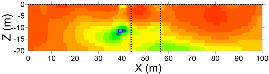
32 Pre-Modeling: DNAPL in Heterogeneous Medium 32

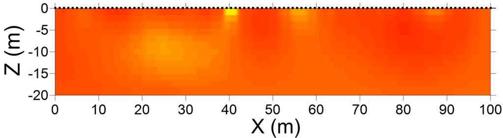
33 Monitoring vs. Detection The Detection Problem A 2-D Crosshole GPR Example: Finding a Plume Electrical Resistivity Electrical Resistivity Electrical Resistivity Anomaly (Plume) Cross Section Tomogram ohm-m ohm-m ohm-m The needle The haystack + needle Blurry haystack Plume is masked by geologic heterogeneity 33


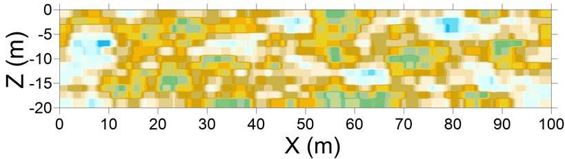
34 Monitoring vs. Detection The Monitoring Problem: Difference Against Background AFTER BEFORE ohm-m Electrical Resistivity ohm-m Difference Tomogram ohm-m Absolute Tomograms - Plume is revealed by subtracting out pre-injection background, removing unrelated spatial contrasts (i.e., we removed the haystack) 34
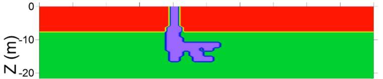
35 Excel-Based Pre-Modeling for Electrical Resistivity Imaging For a given site, a user will be able to enter: Proposed number and spacing of surface electrodes* Effect of adding borehole electrodes* Assumed location of target Assumed conductivities of target and surrounding region Assumed noise levels* *Selections given In terms of determining the resolution capabilities for a particular subsurface structure, these variables have the greatest effect σ 3 σ 1 σ 2 Conductivity (σ) σ 1 = vadose zone σ 2 = saturated zone σ 3 = DNAPL 35

36 SEER Scenario Evaluator for Electrical Resistivity Spreadsheet functionality Simple, user-friendly, requires no proprietary software Predict survey outcomes for hypothetical target and measurement scenarios 3 template targets included in the spreadsheet can be modified by the user DNAPL plume LNAPL plume Blocks Plan to serve from USGS website and publish in a peer-review journal 36

37 SEER Will Reduce Misuse/Overselling of Geophysical Technologies Misrepresentation of geophysics capabilities by service providers Effective technology transfer activities can address this issue and empower RPMs to make informed decisions 37
38 Other Topics Covered in the Geophysics 2-Part Webinar Series June 30, 2016 Geophysical tomography (imaging) - next July 28, 2016 Borehole geophysical logging Geophysical characterization of the hydrogeologic framework at remediation sites Geophysical monitoring of remedial treatments 38
39 Conclusions Take-away messages Geophysical methods have potential to improve site characterization and performance monitoring while reducing costs Geophysical methods complement and do not replace conventional approaches Pre-modeling surveys are critical to ensuring appropriate applications of geophysical technology New, user-friendly tools will facilitate pre-modeling and support informed method selection 39
40 Benefits of Using Geophysics (Correctly) Time and cost reductions Reduce drilling costs needed to characterize site hydrogeologic framework and contamination Expanded spatiotemporal information Fill gaps in space that plague direct data (interpolation) Minimally invasive sampling Reduce likelihood of cross-contamination and human exposure associated with drilling Scale Scale-appropriate information for parameterizing flow and transport models 40
41 Acknowledgments Fred Day Lewis (USGS, Office of Groundwater, Branch of Geophysics) Judy Robinson (Rutgers University) Neil Terry (Rutgers University) Carole Johnson (USGS, Office of Groundwater, Branch of Geophysics) Steve Hammett (NAVFAC EXWC) 41
42 SERDP and ESTCP Webinar Series ER T2 Geophysics: A Technology Transfer Program for Facilitating Effective use of Geophysics for Environmental Characterization and Monitoring at DoD Sites Speaker Contact Information Lee Slater lslater@rutgers.edu;
43 SERDP and ESTCP Webinar Series Q&A Session 1
 Concepts: Opportunities and Limitations Judy Robinson, Ph.D.")
44 SERDP and ESTCP Webinar Series Geophysical Tomography Electrical Resistivity Tomography (ERT) Concepts: Opportunities and Limitations Judy Robinson, Ph.D. Rutgers University
45 Agenda Overcoming limitations of traditional hydrogeological characterization Electrical resistivity tomography (ERT) Concepts and field implementation Guidelines to a successful field campaign Surface and borehole examples Key message: When used appropriately, ERT (1) can help resolve the hydrogeologic framework controlling fluid flow, and (2) may provide indirect information on subsurface transient processes 45


46 Hydrogeological Characterization Boreholes Expensive Spatial interpolation required Small sampling volume of cores/borings Challenges Subsurface heterogeneity Drilling creates unwanted hydraulic pathways/exposure to contaminants 46

47 Geophysical Characterization Geophysical data Improved spatial coverage Minimally invasive Cost-effective However Limited resolution Resistivity/conductivity must be linked to parameter of interest Most powerful when interpreted jointly with other geophysical or hydrologic data 47

48 Goal of Geophysical Characterization Inversion Automated Resistivity Instrument 2D or 3D distribution of resistivity and/or chargeability Petrophysical transformations may be used to map parameters of interest 48
: the ability")

49 Introduction: Electrical Resistivity Tomography (ERT) The Geoscience equivalent of medical imaging Electrical Resistance (Ω): the ability of a material to conduct an electrical current Tomography: a method of producing a 3D image of the internal structures of a solid object 49
 (n+2) a a na a C+ C- P+ P- ρ a = R K C = current electrode P = potential electrode Apparent resistivity Geometric factor,")
50 Electrical Resistivity Tomography (ERT) Resistance (W) Δ Electrode Δ C+ P+ P- C- a a a Voltage (V) Current (A) Wenner a a a C+ P+ P- C- K = 2πa Dipole-Dipole K = πn (n+1) (n+2) a a na a C+ C- P+ P- ρ a = R K C = current electrode P = potential electrode Apparent resistivity Geometric factor, K 50


51 Field Implementation SURFACE BOREHOLE Metal stakes Hose clamps Electrodes field deployment 51

 Hose clamps Packer")

52 Borehole Electrode Arrays Design complements field application Electrode Array Airline to one or more packers (orange tubing) Hose clamps Packer Water sample line (white tubing) Electrodes Packer SERDP and ESTCP Webinar Series (#35) 52

53 instrumentation SURFACE Field Implementation BOREHOLE Resistivity instrument can be operated on-site or remotely field deployment 53

54 3D ERT Surface Implementation 54

55 Time-Lapse ERT Inversion Difficult to view small changes at each time-step Difference imaging focuses on changes in subsurface Slide credit: Timothy Johnson, PNNL 55
56 GUIDELINES TO A SUCCESSFUL ERT CAMPAIGN

57 Survey Design Q: What is the depth and spatial extent of the intended target? D x (ft) 1. As electrode spacing increases: The depth of penetration increases Resolution of features decreases 2. Resolution of features decreases as the distance from electrodes increases Depth (ft) H Ideal if D/H < 0.75 Electrode (in borehole) Increasing model sensitivity to field data 57
58 Survey Design (Cont d) 3. Nested arrays: better at resolving horizontal layering Dipole-dipole arrays: better at resolving vertical contacts (lower signal-tonoise ratio) 4. The number of measurements is likely to be controlled by: The time available to acquire field data Spatial and instrument limitations at the site Wenner (nested) C+ P+ P- C- a a a a Dipole-Dipole na C+ C- P+ P- a 58

59 Realistic Expectations: Example 1 depth (m) depth (m) Log 10 resistivity (Ω-m) Simulations can determine if the electrode spacing and measurement sequence is reasonable to resolve an expected model x (m) 59
 depth (m) depth (m) depth (m) depth (m) 0-10- 20-0- 10-20- 0-10-")
 Resistivity (ohm m) 100 50 5")
60 Realistic Expectations: Example electrodes 1 m spacing depth (m) depth (m) depth (m) depth (m) depth (m) Model x (m) Synthetic result Target is too deep to resolve x (m) Resistivity (ohm m)

61 Hanford 300 Area DoE ER64561 ERT SURFACE EXAMPLE 61
62 Investigating the Hydrogeological Framework at Hanford Contaminated aquifer A critical boundary directing flow towards river Paleochannels incised into the Ringold unit suspected to channel flow towards the river 62


63 2D Resistivity Surface Imaging Line 0 Line 2 Line 4 2D ERT lines Surface resistivity survey line 63
![Geophysical Reconstruction of Controls on Groundwater Flow Elevation of Hanford- Ringold contact compared to temperature anomalies (from distributed temperature sensing [DTS]) showing (1)](/docs-images/95/123914179/images/64-0.jpg "groundwater-surface water exchange locations, and (2) contours of uranium concentrations (mg/l) in aquifer from boreholes Geophysical imaging of paleochannel controlling contaminated groundwater")
64 Geophysical Reconstruction of Controls on Groundwater Flow Elevation of Hanford- Ringold contact compared to temperature anomalies (from distributed temperature sensing [DTS]) showing (1) groundwater-surface water exchange locations, and (2) contours of uranium concentrations (mg/l) in aquifer from boreholes Geophysical imaging of paleochannel controlling contaminated groundwater flow 64
")

65 Former Naval Air Warfare Center (NAWC) ER Brandywine DRMO ER-0717 ERT BOREHOLE EXAMPLES
")
66 NAWC Characterization ERT Image 3D cross borehole optimized ERT sequence Alternating conductive and resistive layering partly resulting from the alternating laminated and massive mudstones at the site Fractured mudstone sequence at the Naval Air Warfare Center (ER ) 66
 t=4 t=6 Injection t=7")
67 NAWC Time-Lapse ERT: Amendment Injection into Outer Borehole t=1 t=3 elapsed time (t) t=4 t=6 Injection t=7 t=8 67
68 Brandywine DRMO 8 Chem sample wells 7 ERT/Chem wells 35 Chem sample ports 65 electrodes ERT wells: 15 2 feet spacing. 2 inch Sampling ports at 11,19 and 26 feet Sampling wells: sampling ports at 11 and 19 feet. Well screen at bottom (26 feet) ERT/IP Well Injection #1 Electrodes Sample Well Injection #2 Sample Ports Groundwater flow to West ~60 ft/year 68
 Time-lapse (a) Background Continuous, automated, monitoring Slide credit Timothy Johnson, PNNL")
69 Brandywine Time-Lapse ERT 8 Chem sample wells 7 ERT/Chem wells 35 Chem sample ports 165 electrodes (b) Time-lapse (a) Background Continuous, automated, monitoring Slide credit Timothy Johnson, PNNL 69
70 Conclusions Take-away messages ERT can help define hydrogeological framework and structures controlling groundwater flow and transport ERT can detect proxies of contaminants and transformations ERT cannot visualize contaminant concentration (e.g., DNAPL) directly 70
71 Benefits Time and cost reductions Reduce drilling costs needed to characterize site hydrogeologic framework and contamination Expanded spatiotemporal information Fill gaps in space that plague direct data (interpolation) Minimally invasive sampling Reduce likelihood of cross-contamination and human exposure associated with drilling Scale Scale-appropriate information for parameterizing flow and transport models 71
 Carole Johnson (USGS, Office of Groundwater, Branch of Geophysics) Neil Terry (Rutgers")
72 Acknowledgments Lee Slater (Rutgers University) Fred Day Lewis (USGS, Office of Groundwater, Branch of Geophysics) Carole Johnson (USGS, Office of Groundwater, Branch of Geophysics) Neil Terry (Rutgers University) 72
73 SERDP and ESTCP Webinar Series ER T2 Geophysics: A Technology Transfer Program for Facilitating Effective use of Geophysics for Environmental Characterization and Monitoring at DoD Sites Speaker Contact Information Judy Robinson judy.robinson@rutgers.edu;
74 SERDP and ESTCP Webinar Series Q&A Session 2
75 SERDP and ESTCP Webinar Series The next webinar is on July 14, 2016 Remote Methods for Water Conservation
76 SERDP and ESTCP Webinar Series Survey Reminder Please take a moment to complete the survey that will pop up on your screen when the webinar ends
USER S GUIDE. ESTCP Project ER
 USER S GUIDE Demonstration of a Fractured Rock Geophysical Toolbox (FRGT) for Characterization and Monitoring of DNAPL Biodegradation in Fractured Rock Aquifers ESTCP Project ER-201118 JANUARY 2016 F.D.
Site Characterization & Hydrogeophysics
 Site Characterization & Hydrogeophysics (Source: Matthew Becker, California State University) Site Characterization Definition: quantitative description of the hydraulic, geologic, and chemical properties
Joint inversion of geophysical and hydrological data for improved subsurface characterization
 Joint inversion of geophysical and hydrological data for improved subsurface characterization Michael B. Kowalsky, Jinsong Chen and Susan S. Hubbard, Lawrence Berkeley National Lab., Berkeley, California,
A Short Course in Contaminated Fractured Rock Hydrogeology and Geophysics
 A Short Course in Contaminated Fractured Rock Hydrogeology and Geophysics An Eight Hour Geophysics Course Offered Through the Environmental Professionals' Organization of Connecticut Date: Nov 19, Nov
Geophysical Characterization and Monitoring of Groundwater/Surface-Water Interaction in the Hyporheic Corridor at the Hanford 300 Area
 Geophysical Characterization and Monitoring of Groundwater/Surface-Water Interaction in the Hyporheic Corridor at the Hanford 300 Area L. Slater 1, F. Day-Lewis 2, R. Versteeg 3, A. Ward 4, J. Lane 2,
Case Study: University of Connecticut (UConn) Landfill
 Landfill") Case Study: University of Connecticut (UConn) Landfill Problem Statement:» Locate disposal trenches» Identify geologic features and distinguish them from leachate and locate preferential pathways in fractured
Case Study: University of Connecticut (UConn) Landfill Problem Statement:» Locate disposal trenches» Identify geologic features and distinguish them from leachate and locate preferential pathways in fractured
Thank you for signing in early
 SERDP and ESTCP Webinar Series Thank you for signing in early The webinar will begin promptly at 12:00 pm ET, 9:00 am PT SERDP and ESTCP Webinar Series The webinar will begin promptly at 12:00 pm ET, 9:00
Applied Geophysics for Environmental Site Characterization and Remediation
 Applied Geophysics for Environmental Site Characterization and Remediation MSECA Webinar September 24, 2015 John Mundell, P.E., L.P.G. Ryan Brumbaugh, L.P.G. MUNDELL & ASSOCIATES, INC. Webinar Objective
Resistivity & IP methods
 International PhD Course in HYDROGEOPHYSICS Resistivity & IP methods Andrew Binley Lancaster University Overview We have demonstrated links between hydrological and geophysical properties and show the
Use of Non-Invasive Near-Surface Geophysics for Managing Brine Releases
 Use of Non-Invasive Near-Surface Geophysics for Managing Brine Releases Presented by: Brent W. Barker, Staff Geophysicist Remediation Technologies Symposium 2012 Imagine the result Co-Authors Boyce L.
Geophysics for Environmental and Geotechnical Applications
 Geophysics for Environmental and Geotechnical Applications Dr. Katherine Grote University of Wisconsin Eau Claire Why Use Geophysics? Improve the quality of site characterization (higher resolution and
Aquitard Characterization The Legend of Indiana s Magic Clay Layer. Juliet Port, LPG #2214 July 2014
 Aquitard Characterization The Legend of Indiana s Magic Clay Layer Juliet Port, LPG #2214 July 2014 Topics What is an Aquitard? Why do we care? Review of Indiana glacial geology Conceptual Framework Investigation
Geophysical Exploration in Water Resources Assessment. John Mundell, P.E., L.P.G., P.G. Ryan Brumbaugh, L.P.G. Mundell & Associates, Inc.
 Geophysical Exploration in Water Resources Assessment John Mundell, P.E., L.P.G., P.G. Ryan Brumbaugh, L.P.G. Mundell & Associates, Inc. Presentation Objective Introduce the use of geophysical survey methods
Geoelectricity. ieso 2010
 Geoelectricity ieso 2010 1 RESISTIVITY SURVEY AT VENETO VILLA GRITTI AT THE TOWN OF TREVISO (VENETO REGION) The survey was carried out to verify the underground presence of the fondations of a rustic building.
Monitoring of In-Situ Chemical Oxidation (ISCO) with Time Series Geophysical Surveys
 with Time Series Geophysical Surveys") Monitoring of In-Situ Chemical Oxidation (ISCO) with Time Series Geophysical Surveys Philip T. Harte, P.G. U.S. Geological Survey ptharte@usgs.gov 603-226-7813 U.S. Department of the Interior U.S. Geological
Monitoring of In-Situ Chemical Oxidation (ISCO) with Time Series Geophysical Surveys Philip T. Harte, P.G. U.S. Geological Survey ptharte@usgs.gov 603-226-7813 U.S. Department of the Interior U.S. Geological
Geophysics Course Introduction to DC Resistivity
 NORAD supported project in MRRD covering Capacity Building and Institutional Cooperation in the field of Hydrogeology for Faryab Province Afghanistan Geophysics Course Introduction to DC Resistivity By
ENVIRONMENTAL AND ENGINEERING GEOPHYSICS
 ENVIRONMENTAL AND ENGINEERING GEOPHYSICS Environmental Engineering MSc 08/09 nd semester COURSE COMMUNICATION DOCUMENT University of Miskolc Faculty of Earth Science and Engineering Institute of Geophysics
Finding Large Capacity Groundwater Supplies for Irrigation
 Finding Large Capacity Groundwater Supplies for Irrigation December 14, 2012 Presented by: Michael L. Chapman, Jr., PG Irrigation Well Site Evaluation Background Investigation Identify Hydrogeologic Conditions
1. Resistivity of rocks
 RESISTIVITY 1) Resistivity of rocks 2) General principles of resistivity surveying 3) Field procedures, interpretation and examples 4) Summary and conclusions INDUCED POLARIZATION 1) General principles
POTASH DRAGON CHILE GEOPHYSICAL SURVEY TRANSIENT ELECTROMAGNETIC (TEM) METHOD. LLAMARA and SOLIDA PROJECTS SALAR DE LLAMARA, IQUIQUE, REGION I, CHILE
 METHOD. LLAMARA and SOLIDA PROJECTS SALAR DE LLAMARA, IQUIQUE, REGION I, CHILE") POTASH DRAGON CHILE GEOPHYSICAL SURVEY TRANSIENT ELECTROMAGNETIC (TEM) METHOD LLAMARA and SOLIDA PROJECTS SALAR DE LLAMARA, IQUIQUE, REGION I, CHILE OCTOBER 2012 CONTENT Page I INTRODUCTION 1 II FIELD
POTASH DRAGON CHILE GEOPHYSICAL SURVEY TRANSIENT ELECTROMAGNETIC (TEM) METHOD LLAMARA and SOLIDA PROJECTS SALAR DE LLAMARA, IQUIQUE, REGION I, CHILE OCTOBER 2012 CONTENT Page I INTRODUCTION 1 II FIELD
Electrical prospecting involves detection of surface effects produced by electrical current flow in the ground.
 Electrical Surveys in Geophysics Electrical prospecting involves detection of surface effects produced by electrical current flow in the ground. Electrical resistivity method Induced polarization (IP)
ENVIRONMENTAL RESTORATION
 ENVIRONMENTAL RESTORATION Geophysical Methods f haracterization and Moniting at Groundwater Remediation Sites Introduction Geophysical methods have potential to improve characterization and moniting at
Hydrological geophysical relationships
 International PhD Course in HYDROGEOPHYSICS Hydrological geophysical relationships Andrew Binley Lancaster University Overview In the course we will concentrate on electrical, electromagnetic and radar
Assessing the Tier 2 Trigger for Fractured Sedimentary Bedrock Sites
 Assessing the Tier 2 Trigger for Fractured Sedimentary Bedrock Sites Ken Lyon, Jennifer Arnold, Louise Burden Advisian WorleyParsons Group RemTech 2015, October 16, Banff, AB INTRODUCTION High level look
Azimuthal Resistivity to Characterize Fractures in a Glacial Till. Mark Boris, University of Saskatchewan Jim Merriam, University of Saskatchewan
 Azimuthal Resistivity to Characterize Fractures in a Glacial Till Mark Boris, University of Saskatchewan Jim Merriam, University of Saskatchewan Abstract Azimuthal resistivity was used to characterize
Patterns in Geophysical Data and Models
 Patterns in Geophysical Data and Models Jens Tronicke Angewandte Geophysik Institut für Geowissenschaften Universität Potsdam jens@geo.uni-potsdam.de Near-surface geophysics Using geophysical tools to
Hydraulic and Water-Quality Characterization of Fractured-Rock Aquifers Using Borehole Geophysics
 Hydraulic and Water-Quality Characterization of Fractured-Rock Aquifers Using Borehole Geophysics John H. Williams Office of Ground Water Troy, New York Flow in Open Borehole Runkel and others (2003) Ambient
David de Courcy-Bower and Samuel Mohr
 Applicability and Limitations of LNAPL Transmissivity as a Metric within Bedrock Formations Insert then choose Picture select your picture. Right click your picture and Send to back. David de Courcy-Bower
Oak Ridge IFRC. Quantification of Plume-Scale Flow Architecture and Recharge Processes
 Oak Ridge IFRC Quantification of Plume-Scale Flow Architecture and Recharge Processes S. Hubbard *1, G.S. Baker *2, D. Watson *3, D. Gaines *3, J. Chen *1, M. Kowalsky *1, E. Gasperikova *1, B. Spalding
11280 Electrical Resistivity Tomography Time-lapse Monitoring of Three-dimensional Synthetic Tracer Test Experiments
 11280 Electrical Resistivity Tomography Time-lapse Monitoring of Three-dimensional Synthetic Tracer Test Experiments M. Camporese (University of Padova), G. Cassiani* (University of Padova), R. Deiana
Electrical Methods. Resistivity Surveying
 Electrical Methods Resistivity Surveying Geologic Resistivity 1101 Resistivity surveying investigates variations of electrical resistance, by causing an electrical current to flow through the subsurface
Geology 228/378 Applied and Environmental Geophysics Lecture 6. DC resistivity Surveys
 Geology 228/378 Applied and Environmental Geophysics Lecture 6 DC resistivity Surveys Direct current (DC) Resistivity. Introduction 2. Current flow in the ground 3. Schlumberger, Wenner, dipole-dipole,
Bedrock Characterization Mottolo Pig Farm Superfund Site
 Bedrock Characterization Mottolo Pig Farm Superfund Site Andrew Drew Hoffman, PE NH Department of Environmental Services andrew.hoffman@des.nh.gov 603.271.6778 1 Acknowledgments GZA GeoEnvironmental (lead
First Technical Report Geophysical experiments near Kajiado town
 First Technical Report Geophysical experiments near Kajiado town Synthesis Report of First case study within the ISGEAG VIA Water project By: Michel Groen *), Harry Rolf **), and Ammon Muiti ***) *) Acacia
Geological Survey of Alabama Groundwater Assessment Program
 Geological Survey of Alabama Groundwater Assessment Program Hydrogeologic Characterization and Groundwater Source Development Assessment for Area 2, Southwestern Alabama Gheorghe M. Ponta, Marlon R. Cook,
Hamed Aber 1 : Islamic Azad University, Science and Research branch, Tehran, Iran. Mir Sattar Meshin chi asl 2 :
 Present a Proper Pattern for Choose Best Electrode Array Based on Geological Structure Investigating in Geoelectrical Tomography, in order to Get the Highest Resolution Image of the Subsurface Hamed Aber
2-D Resistivity Study: The Horizontal Resolution Improvement by Introducing the Enhancing Horizontal Resolution (EHR) Technique
 Technique") Open Journal of Geology, 213, 3, 1-6 doi:1.4236/ojg.213.32b1 Published Online April 213 (http://www.scirp.org/journal/ojg) 2-D Resistivity Study: The Horizontal Resolution Improvement by Introducing the
Open Journal of Geology, 213, 3, 1-6 doi:1.4236/ojg.213.32b1 Published Online April 213 (http://www.scirp.org/journal/ojg) 2-D Resistivity Study: The Horizontal Resolution Improvement by Introducing the
SASKATCHEWAN STRATIGRAPHY GLACIAL EXAMPLE BOULDERS IN GLACIAL DEPOSITS
 SASKATCHEWAN STRATIGRAPHY GLACIAL EXAMPLE BOULDERS IN GLACIAL DEPOSITS 51 SASKATCHEWAN STRATIGRAPHY GLACIAL SURFICIAL STRATIFIED DEPOSITS 52 SASKATCHEWAN STRATIGRAPHY GLACIAL EXAMPLE OF SEDIMENT DEPOSITION
West Coast Research. WESTCARB Technical Director California Energy Commission
 Field Experience from West Coast Research Larry Myer WESTCARB Technical Director California Energy Commission lrmyer@lbl.gov Carbon Capture & Sequestration Public Workshop Bakersfield, CA September 25,
INTRODUCTION TO LOGGING TOOLS
 BY: MUHAMMAD ZAHID INTRODUCTION TO LOGGING TOOLS 1- SPONTANEOUS POTENTIAL (SP) The Spontaneous potential survey, (sp) was one of the first measurements, which was carried out, in a well bore. The SP log
Geophysical Surveys for Groundwater Modelling of Coastal Golf Courses
 1 Geophysical Surveys for Groundwater Modelling of Coastal Golf Courses C. RICHARD BATES and RUTH ROBINSON Sedimentary Systems Research Group, University of St. Andrews, St. Andrews, Scotland Abstract
An Introduction to Geophysical Exploration
 An Introduction to Geophysical Exploration Philip Kearey Department of Earth Sciences University of Bristol Michael Brooks Ty Newydd, City Near Cowbridge Vale of Glamorgan Ian Hill Department of Geology
Measurement, Monitoring and Verification (MMV)
") Measurement, Monitoring and Verification (MMV) Larry Myer USCSC CCS Capacity Building Workshop Charleston, West Virginia October 25, 2011 Outline Why monitor? Information needs Monitoring methods Baselines
Measurement, Monitoring and Verification (MMV) Larry Myer USCSC CCS Capacity Building Workshop Charleston, West Virginia October 25, 2011 Outline Why monitor? Information needs Monitoring methods Baselines
Electrical Resistivity Survey for Delineating Seawater Intrusion in a Coastal Aquifer
 Electrical Resistivity Survey for Delineating Seawater Intrusion in a Coastal Aquifer Sung-Ho Song*, Gyu-Sang Lee*, Jin-Sung Kim*, Baekuk Seong*, Young-gyu Kim*, Myung-Ha Woo* and Namsik Park** Abstract
Appendix B: Geophysical Data (Thesis Appendix, 2013)
") Utah State University From the SelectedWorks of David J Richey 2013 Appendix B: Geophysical Data (Thesis Appendix, 2013) David J Richey, Utah State University Available at: https://works.bepress.com/david_richey/2/
Utah State University From the SelectedWorks of David J Richey 2013 Appendix B: Geophysical Data (Thesis Appendix, 2013) David J Richey, Utah State University Available at: https://works.bepress.com/david_richey/2/
Improved Exploration, Appraisal and Production Monitoring with Multi-Transient EM Solutions
 Improved Exploration, Appraisal and Production Monitoring with Multi-Transient EM Solutions Folke Engelmark* PGS Multi-Transient EM, Asia-Pacific, Singapore folke.engelmark@pgs.com Summary Successful as
Geo-imaging: An Introduction to Engineering Geophysics
 Geo-imaging: An Introduction to Engineering Geophysics Chih-Ping Lin Distinguished Professor, Department of Civil Engineering & Natural Hazard Mitigation Research Center National Chiao Tung University,
Site characterization at the Groundwater Remediation Field Laboratory
 Site characterization at the Groundwater Remediation Field Laboratory WILLIAM P. C LEMENT, STEVE CARDIMONA, ANTHONY L. ENDRES, Boston College, Boston, Massachusetts KATHARINE KADINSKY-CADE, Phillips Laboratory,
Harvey Thorleifson, Director, Minnesota Geological Survey. Status of geological mapping needed for groundwater protection in Minnesota
 Harvey Thorleifson, Director, Minnesota Geological Survey Status of geological mapping needed for groundwater protection in Minnesota Minnesota is located between the Dakotas and Wisconsin, north of Iowa,
High Resolution Geophysics: A Better View of the Subsurface. By John Jansen, P.G., Ph.D., Aquifer Science and Technology
 High Resolution Geophysics: A Better View of the Subsurface By John Jansen, P.G., Ph.D., Aquifer Science and Technology Geologist Use Only Part of the Information Available To Them Most Geologist rely
ambiguity in earth sciences IESO Geophysics Section Eddy hartantyo, Lab Geofisika FMIPA UGM
 ambiguity in earth sciences IESO Geophysics Section Eddy hartantyo, Lab Geofisika FMIPA UGM Pelatihan Tahap II IESO Teknik Geologi UGM Februari 2009 1 Introduction Photos from http://www.eegs.org/whatis/
Groundwater Sustainability at Wadi Al Bih Dam, Ras El Khaimah, United Arab Emirates (UAE) using Geophysical methods
 using Geophysical methods") Groundwater Sustainability at Wadi Al Bih Dam, Ras El Khaimah, United Arab Emirates (UAE) using Geophysical methods Ahmed Murad, Amir Gabr, Saber Mahmoud, Hasan Arman & Abdulla Al Dhuhoori Geology Department
Groundwater Sustainability at Wadi Al Bih Dam, Ras El Khaimah, United Arab Emirates (UAE) using Geophysical methods Ahmed Murad, Amir Gabr, Saber Mahmoud, Hasan Arman & Abdulla Al Dhuhoori Geology Department
2D Resistivity Imaging Investigation of Solid Waste Landfill Sites in Ikhueniro Municipality, Ikpoba Okha Local Government Area,Edo State, Nigeria.
 2D Resistivity Imaging Investigation of Solid Waste Landfill Sites in Ikhueniro Municipality, Ikpoba Okha Local Government Area,Edo State, Nigeria. Iyoha. A, Akhirevbulu O.E, Amadasun C.V.O and Evboumwan
FINAL REPORT GEOPHYSICAL INVESTIGATION VILLAGE ALHAMBRA RETENTION POND SITE THE VILLAGES, FLORIDA
 FINAL REPORT GEOPHYSICAL INVESTIGATION VILLAGE ALHAMBRA RETENTION POND SITE THE VILLAGES, FLORIDA Prepared for Andreyev Engineering, Inc. Oxford, FL Prepared by GeoView, Inc. St. Petersburg, FL August
EXTREMELY FAST IP USED TO DELINEATE BURIED LANDFILLS. Norman R. Carlson, Cris Mauldin Mayerle, and Kenneth L. Zonge
 EXTREMELY FAST IP USED TO DELINEATE BURIED LANDFILLS Norman R. Carlson, Cris Mauldin Mayerle, and Kenneth L. Zonge Zonge Engineering and Research Organization, Inc. 3322 East Fort Lowell Road Tucson, Arizona,
LECTURE 10. Module 3 : Field Tests in Rock 3.6 GEOPHYSICAL INVESTIGATION
 LECTURE 10 3.6 GEOPHYSICAL INVESTIGATION In geophysical methods of site investigation, the application of the principles of physics are used to the study of the ground. The soil/rock have different characteristics
Monitoring and Verification of CO 2 Storage in Geological Formations Sally M. Benson Lawrence Berkeley National Laboratory Berkeley, CA 94720
 Monitoring and Verification of CO 2 Storage in Geological Formations Sally M. Benson Lawrence Berkeley National Laboratory Berkeley, CA 94720 Global Climate & Energy Project (GCEP) International Workshop
University of Wyoming Near-Surface Geophysical Instrument Center & Wyoming Center for Environmental Hydrology and Geophysics
 University of Wyoming Near-Surface Geophysical Instrument Center & Wyoming Center for Environmental Hydrology and Geophysics UWNSG & WyCEHG Groundwater Studies on the Brule Formation near Pine Bluffs,
DOWN-HOLE SEISMIC SURVEY AND VERTICAL ELECTRIC SOUNDINGS RABASKA PROJECT, LÉVIS, QUÉBEC. Presented to :
 DOWN-HOLE SEISMIC SURVEY AND VERTICAL ELECTRIC SOUNDINGS RABASKA PROJECT, LÉVIS, QUÉBEC Presented to : TERRATECH 455, René-Lévesque Blvd. West Montreal, Québec HZ 1Z3 Presented by : GEOPHYSICS GPR INTERNATIONAL
Electrical Surveying (part A)
") Electrical Surveying (part A) Dr. Laurent Marescot Course given at the University of Fribourg (2009) Contact: laurent@tomoquest.com www.tomoquest.com 1 Introduction Electrical surveying Resistivity method
Electrical Surveying (part A) Dr. Laurent Marescot Course given at the University of Fribourg (2009) Contact: laurent@tomoquest.com www.tomoquest.com 1 Introduction Electrical surveying Resistivity method
BOS 100 Overburden and Bedrock Groundwater Remediation Former Dry Cleaning Facility
 BOS 100 Overburden and Bedrock Groundwater Remediation Former Dry Cleaning Facility Site Description Location Central Kentucky Site Use Retail Shopping Center Geologic Setting Inner Bluegrass Bedrock Ordovician
Seismoelectric Ground-flow DC-4500 Locator
 Seismoelectric Ground-flow DC-4500 Locator Introduction The seismoelectric survey is a new technology combined the electro kinetic potential method and geophysical technology. It is applied directly to
Geophysics Course Interpreting DC Resistivity Data
 NORAD supported project in MRRD covering Capacity Building and Institutional Cooperation in the field of Hydrogeology for Faryab Province Afghanistan Geophysics Course Interpreting DC Resistivity Data
CHARACTERIZATION OF FRACTURES IN GEOTHERMAL RESERVOIRS USING RESISTIVITY
 PROCEEDINGS, Thirty-Seventh Workshop on Geothermal Reservoir Engineering Stanford University, Stanford, California, January 30 - February 1, 01 SGP-TR-194 CHARACTERIZATION OF FRACTURES IN GEOTHERMAL RESERVOIRS
INNOVATIVE TECHNIQUES TO INVESTIGATE CONTAMINATION IN FRACTURED BEDROCK
 INNOVATIVE TECHNIQUES TO INVESTIGATE CONTAMINATION IN FRACTURED BEDROCK Abstract Christopher Gaule 1, Kenneth Goldstein 2, Grant Anderson 3 Watervliet Arsenal, located in Watervliet, New York, is the oldest
Geophysics foundations: Seeing underground: Introduction
 Introduction Outline This five page article was written for those involved in the earth sciences who have no background in geophysics. It is intended to explain very briefly how applied geophysics can
Geologging Imagery, Applications and Geological Interpretation. Shea Altadonna 1, Jim Fulton 2, E.I.T.
 Geologging Imagery, Applications and Geological Interpretation Shea Altadonna 1, Jim Fulton 2, E.I.T. 1 Geologist, Advanced Construction Techniques Inc. 1000 N. West St. Ste 1200, Wilmington, DE 19801;
ENVIRONMENTAL RESTORATION
 ENVIRONMENTAL RESTORATION Site Characterization and Remediation in Fractured Rock Introduction Site characterization and remediation in fractured rock affords a unique set of challenges not typically associated
CHARACTERIZATION OF SOIL PROFILE OF DHAKA CITY USING ELECTRICAL RESISTIVITY TOMOGRAPHY (ERT)
") CHARACTERIZATION OF SOIL PROFILE OF DHAKA CITY USING ELECTRICAL RESISTIVITY TOMOGRAPHY (ERT) Mehedi Ahmed ANSARY 1, B.S. Pushpendue BISWAS 2 and Abul KHAIR 3 1 Professor, Department of Civil Engineering
CHARACTERIZATION OF SOIL PROFILE OF DHAKA CITY USING ELECTRICAL RESISTIVITY TOMOGRAPHY (ERT) Mehedi Ahmed ANSARY 1, B.S. Pushpendue BISWAS 2 and Abul KHAIR 3 1 Professor, Department of Civil Engineering
The UK GeoEnergy Test Bed Ceri J Vincent British Geological Survey
 The UK GeoEnergy Test Bed Ceri J Vincent British Geological Survey Thanks to Matthew Hall (GTB Theme Lead for G ERA), Phil Meldrum, Russell Swift, Oliver Kuras, Richard Luckett, Andrew Butcher, Jonathan
Effects of depositional and diagenetic heterogeneitites on fluid flow in Plio -- Pleistocene reefal carbonates of the Southern Dominican Republic
 Viviana Díaz was born in Puerto Rico and received her undergraduate degree from the University of Puerto Rico and her Master's at the University of North Carolina. She is currently working on her PhD at
2D Electrical Resistivity Tomography survey optimisation of solute transport in porous media
 ArcheoSciences Revue d'archéométrie 33 (suppl.) 2009 Mémoire du sol, espace des hommes 2D Electrical Resistivity Tomography survey optimisation of solute transport in porous media Gregory Lekmine, Marc
HYDROGEOPHYSICS. Susan Hubbard. Lawrence Berkeley National Laboratory. 1 Cyclotron Road, MS Berkeley, CA USA.
 HYDROGEOPHYSICS Susan Hubbard Lawrence Berkeley National Laboratory 1 Cyclotron Road, MS 90-1116 Berkeley, CA 94720 USA sshubbard@lbl.gov 1-510-486-5266 Niklas Linde Institute of Geophysics University
THE 4Gs IN PRACTICE: INVESTIGATING HOW THE 4Gs ARE APPLIED IN THE OIL & GAS INDUSTRY
 THE 4Gs IN PRACTICE: INVESTIGATING HOW THE 4Gs ARE APPLIED IN THE OIL & GAS INDUSTRY Society for Underwater Technology, Evening Technical Meeting 14 AUGUST 2013 GEOPHYSICS & PORT DEVELOPMENTS EXPLORING
PETROLEUM GEOSCIENCES GEOLOGY OR GEOPHYSICS MAJOR
 PETROLEUM GEOSCIENCES GEOLOGY OR GEOPHYSICS MAJOR APPLIED GRADUATE STUDIES Geology Geophysics GEO1 Introduction to the petroleum geosciences GEO2 Seismic methods GEO3 Multi-scale geological analysis GEO4
FUNDAMENTALS OF ENGINEERING GEOLOGY
 FUNDAMENTALS OF ENGINEERING GEOLOGY Prof. Dr. HUSSEIN HAMEED KARIM Building and Construction Engineering Department 2012 Preface The impulse to write this book stemmed from a course of geology given by
Developments in Storage and Monitoring for CCUS
 Developments in Storage and Monitoring for CCUS Steve Whittaker Director Energy Research & Development Illinois State Geological Survey 4 th Beijing International Forum on Carbon Capture, Utilization and
Appendix D Fractured Rock Appendix
 Appendix D Fractured Rock Appendix 1.0 Introduction The behavior of LNAPL in fractured bedrock is not necessarily intuitive and is not as easily described using the principles and techniques adopted for
MOUNT POLLEY MINING CORPORATION TECHNICAL REPORT ON MULTI-ELECTRODE RESISTIVITY AND SEISMIC REFRACTION SURVEYS MOUNT POLLEY TAILINGS DAM PROJECT
 MOUNT PLEY MINING CORPORATION TECHNICAL REPORT ON MULTI-ELECTRODE RESISTIVITY AND SEISMIC REFRACTION SURVEYS MOUNT PLEY TAILINGS DAM PROJECT LIKELY, B.C. by Claudia Krumbiegel, M.Sc. Cliff Candy, P.Geo.
First Field Test of NAPL Detection with High Resolution Borehole Seismic Imaging
 1 First Field Test of NAPL Detection with High Resolution Borehole Seismic Imaging Jil T. Geller, John E. Peterson, Kenneth H. Williams, Jonathan B. Ajo!Franklin*, and Ernest L. Majer Earth Sciences Division,
Identified a possible new offset location where the customer is currently exploring drill options.
 GroundMetrics was hired to conduct a Full-Field Resistivity Survey for an oil and gas producer that needed to make crucial decisions to drive profitability at the location. The results saved them hundreds
Geophysics and Mapping. presented by: Stephen Brown
 Geophysics and Mapping presented by: Stephen Brown Recommended book for INIGEMM Geophysics for the mineral exploration geoscientist, by Michael Dentith and Stephen Mudge, Cambridge University Press, 2014.
Storage: Deep Monitoring and Verification
 Storage: Deep Monitoring and Verification IEA GHG Summer School, Austin, TX David White 7 th to 11 th July, 2014 www.slb.com/carbonservices CS1406-063-DW Why Monitor? Manage Risk Risk = (Impact of Undesirable
The Next Generation of Traffic Management Systems
 AASHTO CTSO ITS Working Group Meeting The Next Generation of Traffic Management Systems What Resources Do Agencies Need & Is There Interest to Collaborate With TRB Technical Committees & Other Groups?
Environmental Geophysics for Coastal Management
 Environmental for Coastal Management Paul Donaldson 1, Dr Douglas Bergersen 2, Dr Matthew Barnes 3, Conor Jones 3 Coast To Coast, Hobart April 2018 1 BMT Newcastle, Australia, 2 Acoustic Imaging, Cooroy,
Does the SDCP need inputs from geology?
 The British Geological Survey s Experience and Expertise in Supporting Projects such as the Sirte Depression Connection Project David Ovadia Director of International Kingsley Dunham Centre Keyworth Nottingham
OTC OTC PP. Abstract
 OTC OTC-19977-PP Using Modern Geophysical Technology to Explore for Bypassed Opportunities in the Gulf of Mexico R.A. Young/eSeis; W.G. Holt, G. Klefstad/ Fairways Offshore Exploration Copyright 2009,
Electrical imaging techniques for hydrological and risk assessment studies
 Séminaire IPG le 9 mars 2006 Strasbourg Institute of Geophysics ETH Hoenggerberg CH-8093 Zurich Electrical imaging techniques for hydrological and risk assessment studies Laurent Marescot laurent@aug.ig.erdw.ethz.ch
10. GEOTECHNICAL EXPLORATION PROGRAM
 Geotechnical site investigations should be conducted in multiple phases to obtain data for use during the planning and design of the tunnel system. Geotechnical investigations typically are performed in
Antelope Hills Directionally Drilled Water Well. Theresa Jehn-Dellaport Jehn Water Consultants, Inc.
 Antelope Hills Directionally Drilled Water Well Theresa Jehn-Dellaport Directional Well Applications Deep Bedrock Aquifers Proven Oil field technology Initial Analysis indicates up to 4 times the production
An Open Air Museum. Success breeds Success. Depth Imaging; Microseismics; Dip analysis. The King of Giant Fields WESTERN NEWFOUNDLAND:
 VOL. 7, NO. 4 2010 GEOSCIENCE & TECHNOLOGY EXPLAINED GEO EXPRO VOL. 7, NO. 4 2010 Success breeds Success geoexpro.com Country Profile: Senegal Ocean Bottom Node Seismic WESTERN NEWFOUNDLAND: An Open Air
FRACTURED ROCK Characterization and Remediation. Allan Horneman September 30, 2016
 FRACTURED ROCK Characterization and Remediation Allan Horneman September 30, 2016 Disclaimers and Notices The materials herein are intended to furnish viewers with a summary and overview of general information
A High Resolution Vertical Gradient Approach for Delineation of Hydrogeologic Units at a Contaminated Sedimentary Rock Field Site
 A High Resolution Vertical Gradient Approach for Delineation of Hydrogeologic Units at a Contaminated Sedimentary Rock Field Site Jessica Meyer 2013 - Solinst Symposium High Resolution, Depth-Discrete
Surface and borehole electrical resistivity tomography
 Surface and borehole electrical resistivity tomography Laurent Marescot laurent@tomoquest.com Introduction Surface electrical resistivity surveying is based on the principle that the distribution of electrical
Lesson 1 Introduction to geophysical methods Emanuele Forte
 Lesson 1 Introduction to geophysical methods Emanuele Forte 3 rd September 2016 Naxos, Greece 1 Outline - What is Geophysics - Base concepts: (Geo)Physical parameters Sensitivity Resolution - Active and
Monitoring and Characterization of the Meadowview Lane Landslide: Boyd County, KY
 Monitoring and Characterization of the Meadowview Lane Landslide: Boyd County, KY Matt Crawford Appalachian Coalition for Geologic Hazards in Transportation 13 th Annual Technical Forum Harrisonburg, VA
Initial Borehole Drilling in the Hornepayne and Manitouwadge Area
 MAY 2017 PRELIMINARY ASSESSMENT OF POTENTIAL SUITABILITY Initial Borehole Drilling in the Hornepayne and Manitouwadge Area In 2010, the Nuclear Waste Management Organization (NWMO) began technical and
Geological Mapping using Geophysics
 Geological Mapping using Geophysics Pugin, A.J.M. and T.H. Larson Illinois State Geological Survey, 615 E Peabody Dr., Champaign, IL 61820; E-mail: A.J.M. Pugin at pugin@isgs.uiuc.edu Mapping Techniques.
Influence of Paleochannels on Seepage
 Study 4 Influence of Paleochannels on Seepage Public Draft 2014 Monitoring and Analysis Plan September 2013 August 2012 Influence of Paleochannels on Seepage 1. Statement of Need Historical maps, aerial
A25 Very High Resolution Hard Rock Seismic Imaging for Excavation Damage Zone Characterisation
 A25 Very High Resolution Hard Rock Seismic Imaging for Excavation Damage Zone Characterisation C. Cosma* (Vibrometric Oy), N. Enescu (Vibrometric Oy) & E. Heikkinen (Pöyry Finland Oy) SUMMARY Seismic and