GEOPHYSICAL SURVEY ON THE BADGER PROJECT
|
|
|
- Colleen James
- 5 years ago
- Views:
Transcription
1 GEOPHYSICAL SURVEY ON THE BADGER PROJECT SIMILKAMEEN MINING DIVISION BRITISH COLUMBIA NTS 092H 10 UTM Zone 10, NAD ,500mE / 5,489,800mN Prepared for: DGW Consultants # Alberni Street, Vancouver, British Columbia, V6E 4V2 BY James Thom, M.Sc. January 10, 2012 DGW Consultants Badger Assessment Report Page 1
2 Contents 1.0 SUMMARY INTRODUCTION Property Description and Location Access, Climate, Local Resources and Physiography HISTORY Exploration History Exploration carried out by Florence Hedin (ARIS: & 10802) Exploration carried out by Newmont Exploration (ARIS: 15803) Exploration carried out by BEST ROCKS MINERAL SERVICES (ARIS: 29365) Minfile Showings Covered by the Property GEOLOGY Regional Geology EXPLORATION PROGRAM Mag Geophysical Survey CONCLUSIONS Statement of Qualifications STATEMENT OF COSTS DGW Consultants Badger Assessment Report Page 2
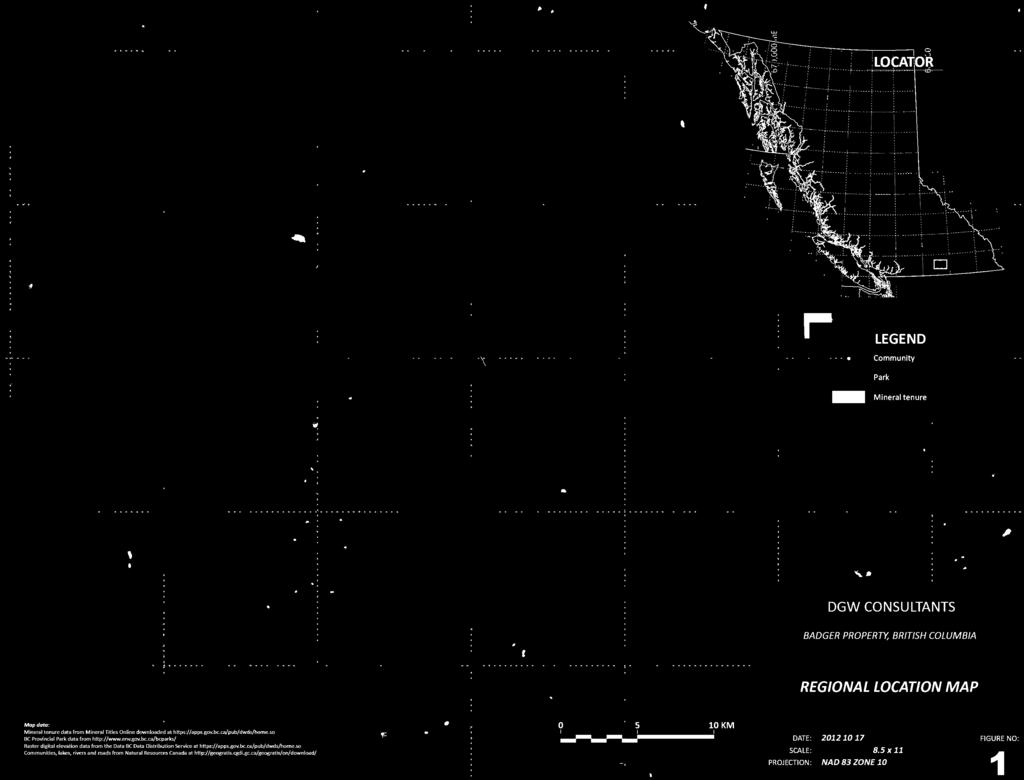
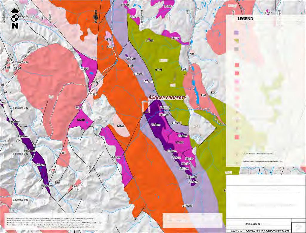
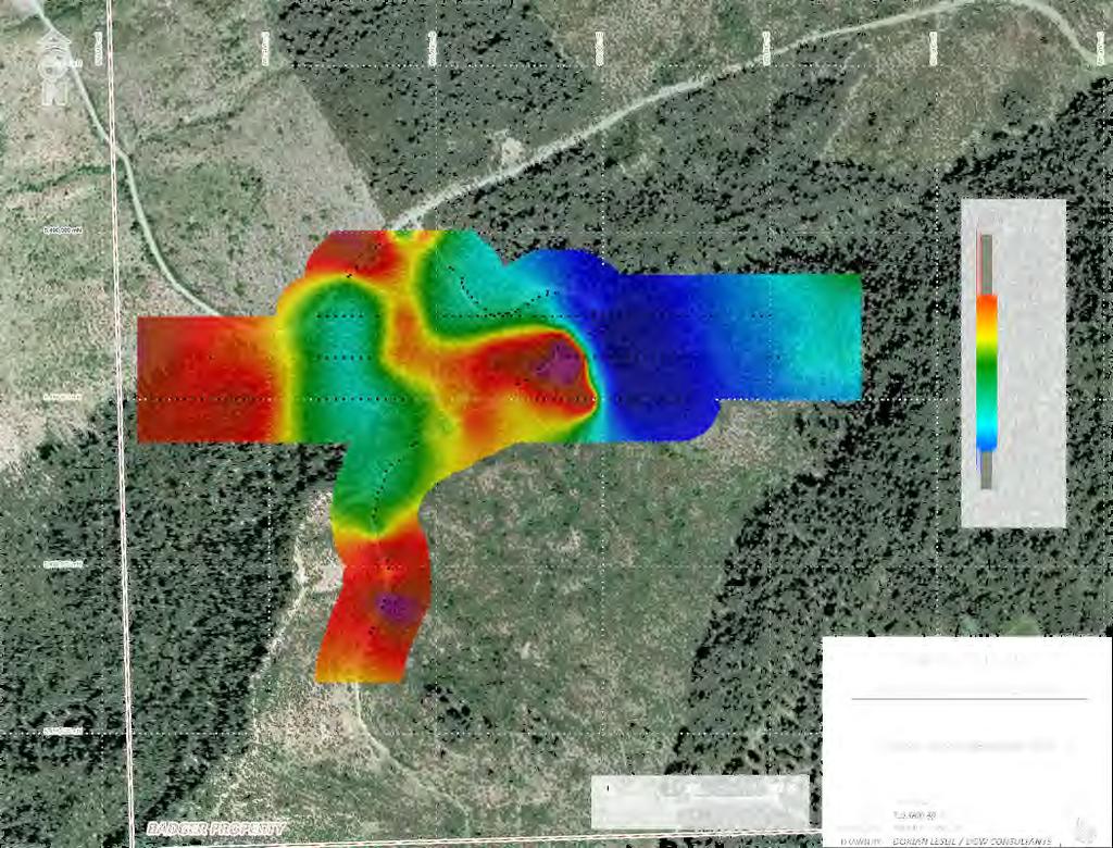
3 LIST OF FIGURES FIGURE 1: Regional Location Map FIGURE 2: Regional Geology Map FIGURE 3: Mineral Tenure Map FIGURE 4: 3D Satellite Image FIGURE 5: Total Field Magnetics A1 A1 A1 A1 A1 APPENDIX 1. Figures APPENDIX 2. Mag Geophysical Results DGW Consultants Badger Assessment Report Page 3
4 1.0 SUMMARY This report describes a program of exploration undertaken during November 2012 on the Badger Property, 100% owned by DGW Consultants and operated by DGW Consultants. The property is currently being held in-trust by Dorian Leslie. The Badger property is located in the Cascade Mountains of southwestern British Columbia approximately 31km west of the town Princeton. This section of the Cascade Mountains is underlain mainly by the Quenellia Terrane, Eagle Plutonic Complex and the Tulameen Ultramafic Complex. The area covered by the Badger property is underlain by the Mount Lytton Complex and the Tulameen Ultramafic Complex. The main deposit type recognized in the Tulameen Ultramafic Complex is the Alaskan-type Pt +/-Os +/-Rh +/-Ir. The British Columbia Ministry of Energy and Mines has identified 19 Minfile occurrences found within the Tulameen Ultramafic Complex. The Badger property consists of two claims, which envelops the Minfile occurrence BADGER (Minfile no. 092HNE210). This minfile occurrence is classified as an Alaskan-type Pt +/-Os +/-Rh +/-Ir. The property is of interest as a host to Pt +/-Os +/-Rh +/-Ir mineralization. The Badger property has a history of exploration going back to From 1980 to 1982, Florence Hedin was the owner of the area now covered by the Badger property and carried out 700m of trenching and 125m of drilling. No assays were reported from the trenching and only two samples were analyzed from the drilling program. In 1986, Newmont Exploration of Canada carried out a magnetic survey over the Badger property. In 2007, Best Rock Mineral Services carried out a stream sediment and prospecting over the Badger property. Fifteen stream sediment samples and two rock samples were collected. No further work was carried out on the ground now covered by the Badger property until the property was acquired by DGW Consultants. In November 2012 DGW Consultants completed a detailed geophysical survey program on the Badger property. The mandate of the program was to carry out a total magnetic field survey over the BADGER minfile occurrence in order to aid in the geological interpretation of this area. The geophysical survey was successful in collecting line km s covering an area of ~0.16km 2 in the BADGER minfile area. DGW Consultants Badger Assessment Report Page 4
5 2.0 INTRODUCTION This report has been written in order to satisfy assessment requirements for SOW: This report describes the geology, a brief work history and the geophysical survey carried out during November, 2012 on the Badger claim group, 100% owned and operated by DGW Consultants. The Badger claim group is currently being held in trust by Dorian Leslie. The 2012 geophysical survey was carried out by the author and an assistant. All UTM locations given are from the NAD83 ZONE10 projection. 2.1 Property Description and Location The Badger Property is located in the Similkameen Mining Division, in the Yale-Lilooet Electoral District, of south-central British Columbia, Canada. The Badger property is located in the Cascade Mountains of southwestern British Columbia approximately 31km west of the town Princeton. The area where work took place is centered roughly at 650,500mE / 5,489,800mN. The Badger property is situated on N.T.S. map sheet 092H (1:250,000), 092H/10 (1:50,000) and 092H/056 (1:20,000). The Badger property consists of one claim group. The claim group consists of two (2) contiguous claims covering approximately hectares. The Badger Property is 100% owned DGW Consultants and is currently being held in-trust by Dorian Leslie. Figures 1, 3, and 4 illustrate the project location and infrastructure. 2.2 Access, Climate, Local Resources and Physiography Access to the central portion of Badger group of claims is available from the east beginning in the town of Tulameen, north of Princeton on 24 km of paved road, and traveling 23 km along the well maintained, active (and often busy) Lawless Creek and Britton Creek Forest Service Roads (FSR) connecting to the main access intersection 4 km northwest of Murphy Lakes. Road access is also available from the north via the Coquihalla Highway from the Coquihalla Lakes turnoff, and heading south along a wide, main-haul logging road to the intersection near Murphy Lakes. Vegetation consists of dense stands of mixed lodgepole pine, fir, balsam and spruce trees where the slope is not too steep. Grasses, wildflowers, blackberries, and small shrubs inhabit areas either steep or recently disturbed by logging activity. The northern pine beetle has devastated a large area to the northeast of the claims, and pine beetle damage is evident throughout the claim area, although to a limited extent. Active and old logging blocks are clearly visible, and the Badger showing area has been logged and reforested approximately 20 years ago. The climate is moderate to arid in the summer months; the usual hot, dry climate typical of the region is mitigated somewhat by the elevation. The majority of the precipitation in the area falls as snow in the winter months, especially at the higher elevations. The snow-free season is generally from May to October, but can be shortened considerably at the upper elevations in some years. The claims are situated between 900 m and 1400 m elevation. Within the claim area the soil is generally poorly developed and largely composed of glacial till, except where steep slopes have allowed erosion to remove the overburden. The higher elevation DGW Consultants Badger Assessment Report Page 5
6 areas have a thin veneer of mixed locally derived weathered rock fragments and glacial till. The till increases rapidly in thickness down slope, except in the immediate vicinity of steep-walled, bedrock-cutting, year-round active drainages. Talus slopes are locally developed near exposed outcrops, and road cuts have removed the overburden in many places, exposing the local bedrock. Table 1. Badger Claim Group OWNER CLAIM NAME TENURE # Good to date SIZE (Ha) Dorian Leslie /nov/22* Dorian Leslie /nov/22* *Good to date is based on the acceptance of this report associated with SOW: DGW Consultants Badger Assessment Report Page 6
7 3.0 HISTORY Where no specific reference is listed, information has been taken from the British Columbia Minister of Mines Annual reports, from the BC Geological Survey Branch Mineral Inventory File (MINFILE) and Ministry of Mines. 3.1 Exploration History The Badger property has a history of exploration going back to From 1980 to 1982, Florence Hedin was the owner of the area now covered by the Badger property and carried out 700m of trenching and 125m of drilling. In 1986, Newmont Exploration of Canada carried out a magnetic survey over the Badger property. In 2007, Best Rock Mineral Services carried out a stream sediment and prospecting over the Badger property. Fifteen stream sediment samples and two rock samples were collected. No further work was carried out on the ground now covered by the Badger property until the property was acquired by DGW Consultants Exploration carried out by Florence Hedin (ARIS: & 10802) From 1980 through to 1982, Florence Hedin, conducted prospecting, trenching and diamond drilling. Copper from 1 to 1.5 % and up to 2.4 g/t gold was reported in samples from areas trenched in a coarse pyroxenite phase of the TUC. Approximately 700 m of trenching were performed. No assays from this program are recorded. Diamond drilling, consisting of two holes totalling 125 m were drilled at the northern contact of the TUC with metavolcanic rocks on the Badger claim. Minor chalcopyrite with magnetite was encountered in a breccia within the metavolcanic rocks over 5.8 m section in DDH Hm Only gold, copper, and iron were analysed; only iron was significantly enriched. A 21 m ultramafic section was intercepted in the bottom of DDH Hm 88-2, but was not analysed Exploration carried out by Newmont Exploration (ARIS: 15803) In 1986, Newmont Exploration of Canada carried out a magnetic survey totalling 9.2 km. The survey grid was conducted on 100m spaced lines at 25m intervals.. A magnetic survey was carried out on this grid Exploration carried out by BEST ROCKS MINERAL SERVICES (ARIS: 29365) In 2007, Best Rock Mineral Services carried out a stream sediment and prospecting over the Badger property. Fifteen stream sediment samples and two rock samples were collected. No significantly anomalous base metals results were received in either the rock or the stream analyses. DGW Consultants Badger Assessment Report Page 7
8 3.3 Minfile Showings Covered by the Property There is one MINFILE report describing one showing on the Badger Property. The MINFILE name for this historic workings is; BADGER. A description of these workings is listed in Table 2 and described below. Table 2. Property Minfile Details MINFILE MINFILE Name(s) Number Status Commodities Most Recent Sampling Highlights BADGER 092HNE210 Showing Cu, Au, PGE 2.4ppm Au & 1.5% Cu-inrock (ARIS: 9381) BADGER This copper showing outcrops on the west side of Grasshopper Mountain, 970 metres northeast of the confluence of Illal and Britton creeks and 11.5 kilometres due west of the town of Tulameen. The occurrence is hosted in hornblende clinopyroxenite of the Early Jurassic Tulameen Ultramafic Complex, a zoned Alaskan-type intrusive complex. The showing is 100 metres east of the contact with metasediments and metavolcanics of the Upper Triassic Nicola Group. A 210-metre wide band of coarse pyroxenite contains disseminated blebs of chalcopyrite and pyrite. Selected grab samples assayed between 1 and 1.5 per cent copper and trace to 2.4 grams per tonne gold (Assessment Report 9381, page 2). DGW Consultants Badger Assessment Report Page 8
9 4.0 GEOLOGY 4.1 Regional Geology The Badger claim is underlain by three principal rock types: the Nicola Group metavolcanics and metasediments of Triassic Age, the Tulameen Ultramafic Complex of late Triassic Age (Findlay, 1969), and the Coast Intrusion Eagle Granodiorite of Jurassic to Cretaceous Age. The geophysical work was conducted over the Tulameen Ultramafic Complex only, and this unit is described in the following paragraphs. The Tulameen Intrusion, measuring approximately 6 x 17 km, is a zoned ultramafic - gabbro complex, a small portion of which occupies the south eastern quarter of the Badger claim. The complex displays a crudely developed concentric zoning of several lithologies, which generally follows a pattern of dunite in the core, with successive shells of minor peridotite, olivine clinopyroxenite, hornblende and/or magnetite clinopyroxenite with felsic rocks on the margin (St. Louis, 1986). Some mixed gabbroic rocks and hornblende pyroxenite/hornblendite occur locally on the Badger claim. The contacts between the ultramafic units are poorly exposed on the property. Chromite in the Tulameen Complex is Fe rich and generally occurs as disseminated grains in dunite and to a lesser extent with in olivine clinopyroxenite, constituting less than 20 volume percent of both rock types (St. Louis, 1986). Platinum occurrences are associated with chromite. The chromite lenses and pods show no preferred attitudes and no systematic distribution with in the dunite (Findlay, 1963). Magnetite is present in all rock units of the Tulameen Ultramafic Gabbro Complex, although the pyroxenite lithologies peripheral to the dunite are known to contain the highest magnetite concentrations. DGW Consultants Badger Assessment Report Page 9
10 EXPLORATION PROGRAM In November 2012 DGW Consultants completed a detailed geophysical survey program on the Badger property. The mandate of the program was to carry out a total magnetic field survey over the BADGER minfile occurrence in order to aid in the geological interpretation of this area. 5.2 Mag Geophysical Survey Grid Information The Badger geophysical survey consisted of one grid given the name Badger. The Badger grid consisted of 3 east-west lines (Figure 5). Line and station labels for the grid were based on UTM positions of the stations. The lines were spaced at 50m and were between 700 and 900 m long. Stations were spaced at 10m and lines were tied together along roads. Station location in the field was determined by going to a waypoint using a Garmin 62CSX GPS. Waypoints for each survey station were preloaded into the GPS and accuracy ranged from +/-3 to +/-10m. Survey Parameters and Instrumentation The magnetic survey utilized a stationary base unit to record the magnetic field to allow for the removal of the diurnal variation in the measured data. The base station recorded data at 3 second intervals. The mobile units recorded the total magnetic field every 10m along the grid line traverses. Calibration measurements were taken by the mobile units at the start and end of each day to account for level shifts between the different instruments and to get a sense of the error in the data. The physical location of the base station and the calibration stations for the Badger grid are E/ N and E/ N, respectively. Geophysical Techniques Magnetic Survey Method Magnetic intensity measurements are taken along survey traverses and are used to identify metallic mineralization related to magnetic material in the ground (e.g., magnetite and/or pyrrhotite). Magnetic data are also used as a mapping tool to distinguish rock types and to identify faults, bedding, structure and alteration zones. Line and station intervals are usually determined by the size and depth of the exploration targets. The magnetic field has both amplitude and a direction. The most common technique used in mineral exploration is to measure just the amplitude component using an overhauser magnetometer. The instrument digitally records the survey line, station, total magnetic field and time of day at each station. After each day of surveying, data are downloaded to a computer for archiving and further processing. The earth s magnetic field is continually changing (diurnal variations) so field measurements are calibrated to these variations. The most accurate technique is to establish a stationary base station magnetometer to continually monitor and record the magnetic field over the course of a day. The base station and field magnetometers are synchronized on the basis of time and computer software is used to correct the field data for the diurnal variations. DGW Consultants Badger Assessment Report Page 10
11 Data Processing Acquisition and Quality Assurance Measures On each day of surveying, geophysical and location information was dumped to external computers for archiving and data processing. Initial quality control of the data was completed by the survey crew at the camp and then sent to DGW Consultants Ltd. in Vancouver, BC, for final quality control, processing and mapping. Location information measured in the field (ground distances, slopes, azimuths, and GPS control points) are imported into a database. Within the database, automatic calculations are performed to generate UTM coordinates for every survey station. A visual review can then be performed to verify the locational information. The Magnetic data is corrected for diurnal variation using the following formula: Datacor=Dataraw Database+ Datum where Datacor is the corrected data, Dataraw is the raw data from the mobile magnetometer, Database is the base station reading for the same time period, and Datum = 55000nT. In the final spreadsheet, suspect or poor quality points are flagged and removed. Calibration readings are verified to ensure the morning and afternoon readings are within set tolerances to determine instrumentation repeatability and noise of operator. In addition, any static shifts (differences) between multiple the instruments or even between the different days can be corrected for. Equipment GSM-19 Overhauser combination Magnetometer Resolution: 0.01 nt, magnetic field gradient Accuracy: 0.2 nt over operating range Range: 20,000 to 120,000 nt Gradient Tolerance: Over 10,000 nt/meter Reading: Initiated by keyboard depression, external trigger or carriage return via RS-232C Input/Output: 6 Pin weatherproof connector, RS-232C, and optional analog output Power Requirements: 12V 200 ma peak (during polarization) 30 ma standby 300 ma peak in gradiometer Power Source: Internal 12V, 1,9 Ah sealed lead-acid battery standard, other optional External 12V power source can be used Battery Charger: Input: 110/220V AC, 50/60 Hz and/or 12V DC Output: 12V dual level charging Oper. Temperature: -40C to 60C Battery Voltage: 10V min. to 15V max. DGW Consultants Badger Assessment Report Page 11
12 6.0 CONCLUSIONS In November 2012 DGW Consultants completed a detailed geophysical survey program on the Badger property. The mandate of the program was to carry out a total magnetic field survey over the BADGER minfile occurrence in order to aid in the geological interpretation of this area. The geophysical survey was successful in collecting line km s covering an area of ~0.16km 2 in the BADGER minfile area. The following recommendations are made for the Badger Property in order of priority: 1) Carry out a geophysical magnetic survey to cover the entire property 2) Carry out property wide prospecting and soil surveys DGW Consultants Badger Assessment Report Page 12
13 7.0 Statement of Qualifications I James G.M. Thom certify that: 1. I am an independent consulting geologist residing at 118B west 14 th ave, Vancouver BC, V5Y1W5 and can be contacted at thomjgm@gmail.com 2. I obtained a B.Sc. in Earth and Ocean Sciences at the University of Victoria [2002] and graduated with a M.Sc. in Geology from the University of Toronto [2003]. 3. I have worked in the mineral exploration industry since I supervised the 2012 exploration program described in this report. DGW Consultants Badger Assessment Report Page 13
14 8.0 STATEMENT OF COSTS Breakdown of Costs for 2012 Exploration work: SOW Field Days: November 11 to November 12 Personnel: James Thom 2 $ $1, Rhonda Viani 2 $ $ Field Costs: Field Camp and Supplies Field Communications 2 $100.00/m/d (including camp rental, GPS rental, prospecting and sampling equipment, first aid, generator, field computer and chain saw) Long Distance charges + Motorola 2 way field $ $50.00 radios Sat phone and costs 1 $150/wk $75.00 Camp Consumables Food/fuels $ Survey Consumables Sample bags, survey flagging, pickets etc. $50.00 Transportation: 1 x Truck Rental 2 $110.00/day $ x Snowmobile Rental 2 $55.00/day $ Geophysical Equipment: 2 x mobile units 2 $150.00/unit/day $ x base station 2 $100.00/unit/day $ Office & Engineering: Report Writing based on results of Phase I exploration program $1, GIS/Drafting/Cartography $1, Total estimate cost of the Phase I exploration program $5, DGW Consultants Badger Assessment Report Page 14

15


16


17


18


19
20 East_NAD83_Z11 North_NAD83_Z11 Mag_Raw_nT Mag_base_nT Mag_Corec_nT
21 East_NAD83_Z11 North_NAD83_Z11 Mag_Raw_nT Mag_base_nT Mag_Corec_nT
22 East_NAD83_Z11 North_NAD83_Z11 Mag_Raw_nT Mag_base_nT Mag_Corec_nT
23 East_NAD83_Z11 North_NAD83_Z11 Mag_Raw_nT Mag_base_nT Mag_Corec_nT
24 East_NAD83_Z11 North_NAD83_Z11 Mag_Raw_nT Mag_base_nT Mag_Corec_nT
25 East_NAD83_Z11 North_NAD83_Z11 Mag_Raw_nT Mag_base_nT Mag_Corec_nT
26 East_NAD83_Z11 North_NAD83_Z11 Mag_Raw_nT Mag_base_nT Mag_Corec_nT
27 East_NAD83_Z11 North_NAD83_Z11 Mag_Raw_nT Mag_base_nT Mag_Corec_nT
28 East_NAD83_Z11 North_NAD83_Z11 Mag_Raw_nT Mag_base_nT Mag_Corec_nT
ASSESSMENT REPORT ON THE PEAVINE PROJECT. DGW & Associates # Alberni Street, Vancouver, British Columbia, V6E 4V2
 ASSESSMENT REPORT ON THE PEAVINE PROJECT KAMLOOPS MINING DIVISION BRITISH COLUMBIA NTS 082M 12 Latitude 51 36' 19.0"North -- Longitude --119 47' 27.0"West UTM Zone 11, NAD 83 5720827N 306744E Prepared
PHYSICAL WORK REPORT. the BAY CLAIMS. Omineca Mining Division Smithers, British Columbia N.T.S. 93E 13E/W
 PHYSICAL WORK REPORT the BAY CLAIMS Omineca Mining Division Smithers, British Columbia a N.T.S. 93E 13E/W LATITUDE: 53 57 00 N I LONGITUDE: 127 45 OO W for Home Ventures Ltd. 1201-675 West Hastings Street
2013 GEOLOGICAL ASSESSMENT REPORT SHERIDAN HILL PROPERTY
 2013 GEOLOGICAL ASSESSMENT REPORT ON THE SHERIDAN HILL PROPERTY NEW WESTMINSTER MINING DIVISION BRITISH COLUMBIA NTS 092G07 49 16 31 NORTH LATITUDE, 122 39 48 WEST LONGITUDE PREPARED FOR Sheridan Hill
Report of Gridding and Magnetic Surveys. On the. Munro Property. Munro and Beatty Townships, Ontario. Larder Lake Mining Division
 Report of Gridding and Magnetic Surveys On the Munro Property Munro and Beatty Townships, Ontario Larder Lake Mining Division Claims: 39 4244 For Big Red Diamond Corporation October 3, 2 Timmins, Ontario
PROSPECTORS ASSISTANCE PROGRAM MINISTRY OF ENERGY AND MINES
 BRITISH COLUMBIA PROSPECTORS ASSISTANCE PROGRAM MINISTRY OF ENERGY AND MINES GEOLOGICAL SURVEY BRANCH PROGRAM YEAR: 1999/2000 REPORT #: PAP 99-l 6 NAME: KIM ANSCHETZ PROSPECTORS TlEPORT on the 99 LOUIS
LOGISTICS REPORT PREPARED HARD ROCK GOLD LTD. GROUND MAGNETOMETER SURVEY TENDERFOOT PROJECT
 LOGISTICS REPORT PREPARED FOR HARD ROCK GOLD LTD. GROUD MAGETOMETER SURVEY O THE TEDERFOOT PROJECT KAMLOOPS, B.C., CAADA LATITUDE: 50 49' LOGITUDE: W120 45' BCGS SHEET: 092I077 & 78 TS SHEET: 092I15 MIIG
Prospecting Report 'S Office i DB Property, B.C. -J Negro Creek Nelson Mining District NTS 82F.050. Operator: Kootenay Gold Inc.
 . '.' I"' i9 12 Prospecting Report 'S Office i DB Property, B.C. -J Negro Creek Nelson Mining District NTS 82F.050 Operator: Kootenay Gold Inc. Owner: Darlene Lavoie Work Performed Summer of 2007 Report
GEOLOGICAL MAPPING REPORT ON THE ASH MINERAL CLAIM OSOYOOS MINING DIVISION ASHNOLA RIVER MAP SHEET NTS M092,H019 MCBRIDE CREEK AREA, ASHNOLA RIVER,
 GEOLOGICAL MAPPING REPORT ON THE ASH MINERAL CLAIM OSOYOOS MINING DIVISION ASHNOLA RIVER MAP SHEET NTS M092,H019 LATITUDE 49 o O6, LONGITUDE 120 o 22 MCBRIDE CREEK AREA, ASHNOLA RIVER, KEREMEOS, B.C. CANADA
NEW HAZELTON, OMINECA M.D.,
 PROSPECTING REPORT JUDI 1 TO 6 MINERAL CLAIMS NEW HAZELTON, OMINECA M.D., B.C. MAP 93M/4E, LAT. SS014'N, LONG. 127'33'W OWNED BY: A. L'ORSA ANTHONY L'ORSA Smithers, B.C. 21 February, 1981 TABLE OF CONTENTS
ASSESSMENT REPORT MAGNETOMETER SURVEY GOLDEN ROD, GOLDEN ROD #2. Long.: General Delivery, Vananda, B. C.
 ASSESSMENT REPORT MAGNETOMETER SURVEY GOLDEN ROD, GOLDEN ROD #2 t=/ NTS 92~110w Lat.: Long.: 49O 44' N 124O 34' W Owner: E. Johanson General Delivery, Vananda, B. C. Operator: Rhyolite Resources I nc.
PIOTR LUTYNSKI VANCOUVER, BRITISH COLUMBIA
 AN ASSESSMENT REPORT ON GROUND MAGNETIC SURVEYING CHUCHI PROPERTY FORT ST. JAMES AREA, BRITISH COLUMBIA OMINECA M.D. 55 17 N, 124 31 W NTS 93N/ 7&8 Claims Surveyed: 597976, 597878-597880 Survey Dates:
The Cobalt Rainbow. Airborne geophysical maps show that a north trending aeromagnetic high suggests further undiscovered mineralisation.
 The Cobalt Rainbow The property is located on Greenstone Creek, approximately 4.8 kilometres south west of the creek mouth. The property is located about 24 km due west of Campbell River, in the east-central
REPORT ON MAGNETOMETER SURVEY TIK-1 CLAIM e&f KAMLOOPS MINING DTVISION. by D. Hendry D. C. MILLER. February 3, for
 REPORT ON MAGNETOMETER SURVEY TIK-1 CLAIM 92-1-14 e&f KAMLOOPS MINING DTVISION lat. 50 57 ' 12" long. 121O23 ' 37" OWNER: ST. JOSEPH EXPLORATIONS LIMITED OPERATIOR: ST. JOSEPH EXPLORATIONS LIMITED by D.
for the Greenwood Mining Division, B.C. NTS 82E/7W Latitude 49' 27' W, Longitude 118' 5 Prepared by a= D. Dylan Watt, B.Sc.
 t. b LOGnO: 37~ -08 m. ACTIO#: for the AMP AMP 2 AMP 3 t AMP 4 CLAIMS Greenwood Mining Division, B.C. NTS 82E/7W Latitude 49' 27' W, Longitude 8' 5 %E c,w zc *& a w Prepared by a= -4c. D. Dylan Watt, B.Sc.
ylylahti Copper Oy Distribution: Ministry of Trade and Industry 2 copies Kylylahti Copper Oy, Outokumpu 1 copy Vulcan Resources Ltd, Perth 1 copy
 K ylylahti Copper Oy Kummunkatu 34 83500 Outokumpu, Finland Facsimile: +358 13 830 228 Distribution: Ministry of Trade and Industry 2 copies Kylylahti Copper Oy, Outokumpu 1 copy Vulcan Resources Ltd,
1 CLAIMS GEOPHYSICAL REPORT ON BOYAL SITUATE NORTHEAST OF TILLICUM MOUNTAIN GOLD AREA BURTON - NAKUSP SIQCAEJ MINING DIVISION
 GEOPHYSICAL REPORT ON BOYAL 1 CLAIMS SITUATE NORTHEAST OF TILLICUM MOUNTAIN GOLD AREA BURTON - NAKUSP SIQCAEJ MINING DIVISION CONSULTING GEOLOGIST AUGUST 1983 VANCOUVER B *C INDEX INTRODUCTION ooa,.eoaaa.aaaoaaooaoa~ao~o
Pacific Empire Minerals Provides Copper King RC Drilling Results
 Pacific Empire Minerals Provides Copper King RC Drilling Results November 1, 2018 - Vancouver, BC, Canada - Pacific Empire Minerals Corp. (TSXV: PEMC) ( Pacific Empire, PEMC or the Company ), a hybrid
SECOND and THIRD YEAR ASSESSMENT REPORT PROSPECTING LICENCE M, ROCK CUT PROPERTY, NTS 1N/12, NEWFOUNDLAND. ROY FRENCH (licence holder )
") SECOND and THIRD YEAR ASSESSMENT REPORT Of PROSPECTING On LICENCE 013704M, ROCK CUT PROPERTY, NTS 1N/12, NEWFOUNDLAND. By ROY FRENCH (licence holder ) Work Conducted: Sept. 17, 2008 Nov. 03, 2009 Total
SECOND and THIRD YEAR ASSESSMENT REPORT Of PROSPECTING On LICENCE 013704M, ROCK CUT PROPERTY, NTS 1N/12, NEWFOUNDLAND. By ROY FRENCH (licence holder ) Work Conducted: Sept. 17, 2008 Nov. 03, 2009 Total
REPORT. on the. Omineca Mining Division, British Columbia. Latitude N., Longitude W. NTS map sheet 93F/7E. James W. McLeod, P.Geo.
 REPORT on the CHU MOLYBDENUM PROPERTY Omineca Mining Division, British Columbia Latitude 53 21 N., Longitude 124 37 W. NTS map sheet 93F/7E James W. McLeod, P.Geo. on behalf of Mr. Chris Delorme TABLE
GEOPHYSICAL REPORT ON THE PRINCE GEORGE PORPHYRY PROJECT LYNX PROPERTY
 GEOPHYSICAL REPORT ON THE PRINCE GEORGE PORPHYRY PROJECT LYNX PROPERTY Lynx Property Omenica Mining Division British Columbia Tenure # 841107, 742942, 741962 NTS Sheet 093K MTO Event Number - 5434711 UTM
GOLDCLIFF TULAMEEN PORPHYRY COPPER PROJECT COPPER MOUNTAIN CAMP, BRITISH COLUMBIA THE TROJAN-CONDOR COPPER TARGET HIGHLIGHTS
 Suite 350-885 Dunsmuir Street PF 250 764 8879 TF 866 769 4802 Vancouver, BC, Canada FX604 261 8994 info@goldcliff.com V6C 1N5 GCN.TSXV www.goldcliff.com GOLDCLIFF TULAMEEN PORPHYRY COPPER PROJECT COPPER
PROSPECTING REPORT. Silver Dollar Property. EVENT # TENURE # Tenure Name: GPEX Silver Dollar
 2008-2009 PROSPECTING REPORT Silver Dollar Property EVENT # 4267989 TENURE # 555462 Tenure Name: GPEX Silver Dollar Similkameen Mining Division Map 092H Central Coordinate Reference 120 06 26.9 W Longitude
J.D. Mason, Prof. Engineer. Report on the Reconnaissance Magnetometer Survey. Completed for. North American Platinum Corporation Ltd.
 Report on the Reconnaissance Magnetometer Survey Completed for North American Platinum Corporation Ltd. Olivine Mountain Property, Tulameen, B.C. J.D. Mason, Prof. Engineer. November 28, 1967. Certificate
Verification Rock Geochemical Survey on the Casino Property
 Verification Rock Geochemical Survey on the Casino Property Trail Creek Mining Division British Columbia NTS 082F04 Latitude 49 04 40.3 North Longitude 117 39 1.4 West UTM Zone 11, NAD 83 5436320N 452500E
News Release No GOLD AND COPPER MINERALIZATION DISCOVERED DURING PHASE 2 EXPLORATION AT THE MCBRIDE PROPERTY
 November 19, 2018 TSX Venture Exchange Listed Frankfurt Exchange Listed News Release No. 303-2018 GOLD AND COPPER MINERALIZATION DISCOVERED DURING PHASE 2 EXPLORATION AT THE MCBRIDE PROPERTY Vancouver,
Reconnaissance. Of the. Denis mineral claims. Situated at Kilometer 844 of the Alaska Highway. Liard Mining Division. Northeastern British Columbia
 Reconnaissance Of the Denis mineral claims Situated at Kilometer 844 of the Alaska Highway Liard Mining Division Northeastern British Columbia N.T.S. 94M.075 Latitude 59 42 25 Longitude 127 13 12 Field
GEOPHYSICAL REPORT CHU CHUA PROJECT Green Mountain Group. KAMLOOPS MINING DIVISION NTS 92P/8E, 82M/5W Lat: 51'24' N Long: 120'00' w
 I GEOPHYSICAL REPORT CHU CHUA PROJECT Green Mountain Group KAMLOOPS MINING DIVISION NTS 92P/8E, 82M/5W Lat: 51'24' N Long: 120'00' w I rvm #.,_..._..._._._.- $...-...! 1 VANCOUVER, B.C. 1 G E 0 I, 0.G
for the Greenwood Mining Division, B.C. NTS 82E/7W 29' W, Longitude 118' 53' N Prepared by D. Dylan Watt, B.Sc.
 for the FltE NO: u VOLT 1, VOLT 2, VOLT 3, & VOLT 4 CLAIMS Greenwood Mining Division, B.C. NTS 82E/7W Latitude 49' 29' W, Longitude 118' 53' N Prepared by D. Dylan Watt, B.Sc. #309-1996 Trutch Street Vancouver,
PLATINOIDS IN THE TIJLAMEEN ULTRAMAFIC COMPLEX (92H) INTRODUCTION
 INTRODUCTION") PLATINOIDS IN THE TIJLAMEEN ULTRAMAFIC COMPLEX (92H) By Robert M. St. Louis Department of Geology, University of Alberta INTRODUCTION The Tulameen Ultramafic Complex is approximately 22 kilometres west
PLATINOIDS IN THE TIJLAMEEN ULTRAMAFIC COMPLEX (92H) By Robert M. St. Louis Department of Geology, University of Alberta INTRODUCTION The Tulameen Ultramafic Complex is approximately 22 kilometres west
SAMPLE ID SAMPLE TYPE Au (g/t) Ag (g/t) Cu (%) AuEq**(g/t)
 Ag (g/t) Cu (%) AuEq**(g/t)") GOLDEN RIDGE RESOURCES DISCOVERS NEW ALKALIC CU-AU PORPHYRY TARGET ON ITS HANK PROJECT Kelowna, British Columbia November 22,2017 - Golden Ridge Resources Ltd. ( Golden Ridge or the Company ) (TSXV: GLDN).
GOLDEN RIDGE RESOURCES DISCOVERS NEW ALKALIC CU-AU PORPHYRY TARGET ON ITS HANK PROJECT Kelowna, British Columbia November 22,2017 - Golden Ridge Resources Ltd. ( Golden Ridge or the Company ) (TSXV: GLDN).
REPORT ON DIAMOND DRILLING SUBSTITUTION EAST PROPERTY CLAIMS AND HEBERT TOWNSHIP ONTARIO, CANADA
 REPORT ON DIAMOND DRILLING SUBSTITUTION EAST PROPERTY CLAIMS 1248920 AND 1248921 HEBERT TOWNSHIP ONTARIO, CANADA Adroit Resources Inc. Suite #610-1111 Melville Street Vancouver, British Columbia, Canada
The MAPLE BAY PROJECT Copper Silver - Gold
 The MAPLE BAY PROJECT Copper Silver - Gold Good grade and tonnage potential within close proximity to Tidewater The Maple Bay Copper Silver Gold Project covers highly favourable geological host rocks of
Elephant Mountain, Alaska Intrusive Related Gold Project July Option to Earn 100%
 Elephant Mountain, Alaska Intrusive Related Gold Project July 2018 Option to Earn 100% CORPORATE Corporate DISCLOSURE Disclosure The information contained herein, while obtained from sources which we believe
HOWE COPPER MINE PROJECT HIGH GRADE Cu-Ag with Au
 HOWE COPPER MINE PROJECT HIGH GRADE Cu-Ag with Au The Howe Copper Mine property is located approximately 55 kilometres northwest of Vancouver, BC. It is situated at 1431 metres elevation on the eastern
3 I1 I I Ill 111 II! II 111 II Ill I IlE I I P I
 -7 3 1 1 11111111111111111111111111111111 ll 111! 111 111 111 111 111111111111111 ll 1111111 1 11111111111111 le P GEOCHEMCAL SURVEY OF THE KE AND D'ARCY CLAM GROUPS.. Similkameen Mining Division, B.C.
DÉCOUVERTE Positioned for Discovery in James Bay, Quebec. Investor Presentation, January 2018 by Danae Voormeij, MSc, PGeo
 DÉCOUVERTE Positioned for Discovery in James Bay, Quebec Investor Presentation, January 2018 by Danae Voormeij, MSc, PGeo Location Maps and Infrastructure Location: Durango Resources 100% owned Découverte
RECONNAISSANCE AND SOIL GEOCHEMICAL SAMPLING REPORT PORCUPINE MINING DIVISION ON CLAIM , LANGMUIR TOWNSHIP
 RECONNAISSANCE AND SOIL GEOCHEMICAL SAMPLING REPORT ON CLAIM 1224499, LANGMUIR TOWNSHIP PORCUPINE MINING DIVISION CLM 1224499 NTS: 42A/06 Author: William Randall, P.Geo 1 Table of Contents Work Performed
The survey covered claims, in part or in full, DUCKLING 3, 4, 5, 4 fraction, and 5 fraction.
 514 687-6671 XXX- 602 West Hastin~a StroeP, Vata;sn@ouver, BritlsA fhlum~b~a, Garaadsa B81apphgtaa DISCUSS ION OF MAGNETOMETER SURVEY ON DUCKLING CLAIMS FOR DONNA MINES LTD. (N0P.L.) Submitted to: DONNA
490 20' 30" North Latitude ' 30" West Longitude
 _._.. I CONSULTING GEOLOGISTS 605-602 WEST HASTINGS STREET, VANCOUVER, B.C. V6B 1P2 TELEPHONE: (604) 689-5533 6 I F: ASSESSMENT REPORT ON THE PATSY 1 MINERAL CLAIM ' '?%2% I WHISTLE CREEK, HEDLEY ARE L-l-
UNION MINIERE EXPLORATIONS AND MINING CORPORATION LIMITED ASSESSMENT REPORT ON FITINAT MINERAL CLAIM. Alberni Mining Division Record No.
 M F )( UNION MINIERE EXPLORATIONS AND MINING CORPORATION LIMITED Suite 200, 4299 Canada Way, Burnaby, B.C. V5G 1 H4 Telephone (604) 437-9491 ASSESSMENT REPORT ON GEOCHEMICAL SOIL SURVEYS AND ROCKSAMPLING
ASX Announcement. 28 January Drill results indicate large Porphyry Copper Gold System at Peenam
 ASX Announcement 28 January 2010 Drill results indicate large Porphyry Copper Gold System at Peenam Highlights: 270 metres of visible copper (gold) mineralisation in first diamond core hole at Peenam Prospect
1 FILMED 1. FILE NO:!..rsrru -* -. GRAND TWO CLAIM
 FILE NO:!..rsrru -* -. GRAND TWO CLAIM REPORT ON 1993 ASSESSMENT WORK GRAND TWO CLAIM REC. NO. 301849 NELSON MINING DIVISION NTS MAP SHEET 82F6/W 49 25'51" NORTH 117 18'08" WEST 1 FILMED 1 AUTHOR: R. Jordan,
NTS 082F03SW N W U E N
 Prospecting Report JOCELYN CLAIM NTS 082F03SW N49 09 51 W 117 14 04 11U 482906E 5445737N NELSON MINING DIVISION Martin Ross PO Box 323 Salmo BC V0G 1Z0 Jan 31, 2012 PROSPECTING REPORT JOCELYN MINERAL CLAIM
We are committed to providing accessible customer service. If you need accessible formats or communications supports, please contact us.
 We are committed to providing accessible customer service. If you need accessible formats or communications supports, please contact us. Nous tenons à améliorer l accessibilité des services à la clientèle.
STONE MOUNTAIN. Owner: Kimberly Gale Powell. Technical Report for Tenures: , , , , ,
 STONE MOUNTAIN Owner: Kimberly Gale Powell Technical Report for Tenures: 415067, 415068, 415069, 415070, 415071, 415072. Approximate Property Location Latitude 49 29 3 North Longitude: 120 40 47 West Similkameen
12 tons of high-grade ore was mined from the No. 1 vein with an average grade of 13 g/t gold, 3,250 g/t silver and 23.3% lead.
 DUNWELL MINE GROUP The Dunwell Mine Group (Dunwell, Dunwell East, Bear River/MM and Silvershot properties), which includes the historic, past-producing Dunwell mine, is located 8 km northeast of Stewart
Highlights include: Hole TTD050: 6.12 g/t Au over 7.00 metres from metres o Including g/t Au over 1.18 metres
 GT Gold Continues to Drill Multiple High-Grade Intercepts at Saddle South, Intersecting 12.05 g/t Au Over 3.79 Metres and 9.77 g/t Au Over 5.53 Metres in Hole TTD045 Vancouver, British Columbia December
ANTLER GOLD DRILLS GRAMS PER TONNE GOLD OVER 5.35 METRES AT THE WILDING LAKE GOLD PROJECT, NEWFOUNDLAND
 ANTLER GOLD DRILLS 10.01 GRAMS PER TONNE GOLD OVER 5.35 METRES AT THE WILDING LAKE GOLD PROJECT, NEWFOUNDLAND HALIFAX, NOVA SCOTIA (CNW December 13 th, 2017) Antler Gold Inc. ( Antler ) (TSX- V:ANTL) is
We are committed to providing accessible customer service. If you need accessible formats or communications supports, please contact us.
 We are committed to providing accessible customer service. If you need accessible formats or communications supports, please contact us. Nous tenons à améliorer l accessibilité des services à la clientèle.
ASSESSMENT REPORT PROSPECTING PROGRAM ION/DIRTY JACK PROPERTY NELSON MINING DIVISION N.T.S. MAP SHEET 82F.023 UTM COORDINATES N E
 ASSESSMENT REPORT PROSPECTING PROGRAM ION/DIRTY JACK PROPERTY NELSON MINING DIVISION N.T.S. MAP SHEET 82F.023 UTM COORDINATES 5454800N - 0455235E Work Performed Summer 2007 OWNER >* ' Tom Kennedy >8 404-22
CONSULTING GEOLOGICAL 8: MINING ENGINEERS STINGS STREET DA V6E 2E9 GEOPHYSICAL SURVEY SILVER QUEEN 2 ZEBALLOS AREA. B.C.
 DOLMAGE CAMPBELL & ASSOCIATES (1 975) LTD. CONSULTING GEOLOGICAL 8: MINING ENGINEERS STINGS STREET DA V6E 2E9 '' 1E O L 0 G I C A.L B'x;&a:f2:#& 'SESSMENT REPObT 12, Assessment RESOURCES LTD. 111 ReDort
DiaMine Exploration Inc. Pickle Lake Option Property
 DiaMine Exploration Inc. Pickle Lake Option Property Rock Sampling Program and Field Observations Claims 4249174, 4249175, 4249176 and 4249177, Kapkichi Lake Area (G-2081) And Claims 4249178, 4249179 and
Gold Mountain Group Gold Mtn. A, B, C & D Mineral Claims Record Nos. 697, 698, 699 & 700. Island Mountain Cariboo Mining Division British Columbia
 GOLD POINT RESOURCES LTD. Geophysical Survey Gold Mountain Group Gold Mtn. A, B, C & D Mineral Claims Record Nos. 697, 698, 699 & 700 Island Mountain Cariboo Mining Division British Columbia Vancouver,
FILE NO. ASSESSMENT REPORT VLF-EM GEOPHY S I CS BUCK CLAIMS. Moyie River and Perry Creek Area FORT STEELE MINING DIVISION. NTS 82 F/8 E and 82 G/5 W
 FILE NO. ASSESSMENT REPORT on - VLF-EM GEOPHY S I CS BUCK CLAIMS Moyie River and Perry Creek Area FORT STEELE MINING DIVISION NTS 82 F/8 E and 82 G/5 W Latitude 49 27' N Longitude 116 03' W PETER KLEWCHUK
POTENTIAL OF THE DONGWE COPPER GOLD PROJECT
 POTENTIAL OF THE DONGWE COPPER GOLD PROJECT By Nathan Sabao, P.Geo. September 2015 1 TABLE OF CONTENTS Page 1.0 EXECUTIVE SUMMARY 1 2.0 LOCATION 2 3.0 ACCESS 2 4.0 GEOLOGY 3 5.0 PREVIOUS DRILLING 5 6.0
ASSESSMENT REPORT TITLE PAGE AND SUMMARY
 ASSESSMENT REPORT TITLE PAGE AND SUMMARY TITLE OF REPORT: 2016 Prospecting Report Sphynx Claim TOTAL COST: $167.56 AUTHOR(S): Giacomo Grassi SIGNATURE(S): NOTICE OF WORK PERMIT NUMBER(S)/DATE(S): STATEMENT
Carrapateena Mineral Resources Explanatory Notes April OZ Minerals Limited. Carrapateena Mineral Resources Statement April
 OZ Minerals Limited Carrapateena Mineral Resources Statement April 14 2011 CARRAPATEENA MINERAL RESOURCE STATEMENT April 14, 2011 The Carrapateena Resource Statement relates to an upgrading to an Inferred
ANTLER GOLD EXPLORATION UPDATE, WILDING LAKE GOLD PROJECT, NEWFOUNDLAND
 ANTLER GOLD EXPLORATION UPDATE, WILDING LAKE GOLD PROJECT, NEWFOUNDLAND HALIFAX, NOVA SCOTIA (CNW May 10, 2018) Antler Gold Inc. ( Antler ) (TSX-V:ANTL) is pleased to provide an update on its upcoming
First Year assessment Report on Prospecting and Rock sampling, King George property, License M NTS 12A/05 Newfoundland and Labrador.
 First Year assessment Report on Prospecting and Rock sampling, King George property, License 016679M NTS 12A/05 Newfoundland and Labrador. Submitted by Shawn Rose For Shawn Rose January 2011 Work year
NTS 93L/9W GEOCHEMICAL AND GEOPHYSICAL REPORT MONA CLAIM OMINICA MINING DIVISION. Lati tude 54036'N; Longitude 'W
 GEOCHEMICAL AND GEOPHYSICAL REPORT ON MONA CLAIM OMINICA MINING DIVISION Lati tude 54036'N; Longitude 126018'W NTS 93L/9W April 1981 Paul Plicka Consulting Geologist LOCATION MAP INTRODUCTION TABLE OF
A GUIDE TO WRITING AN ASSESSMENT REPORT ON YOUR CLAIMS
 A GUIDE TO WRITING AN ASSESSMENT REPORT ON YOUR CLAIMS PLEASE NOTE! In the following pages, suggestions and advice are in italics, under each heading. Use as a guideline only. Items in bold should be changed
DSM SYNDICATE DISCOVERS POLYMETALLIC MINERALIZATION WITH TALUS GRAB SAMPLES CONTAINING UP TO PERCENT LEAD AND 18
 DSM SYNDICATE DISCOVERS POLYMETALLIC MINERALIZATION WITH TALUS GRAB SAMPLES CONTAINING UP TO 92.8 GRAMS PER TONNE GOLD, 13,643 GRAMS PER TONNE SILVER, 13.85 PERCENT LEAD AND 18.65 PERCENT COPPER FROM DIFFERENT
Summary of Rover Metals Geologic Mapping Program at the Up Town Gold Project, Northwest Territories
 October 13, 2017 Summary of Rover Metals Geologic Mapping Program at the Up Town Gold Project, Northwest Territories Vancouver, British Columbia, Canada - Rover Metals Corp., Rover, is pleased to provide
Total Magnetic Field and VLF Surveys on the Swayze Property. Claim Swayze Township. Porcupine Mining Division
 1 January, 016 NTS: 041 O 15 Total Magnetic Field and VLF Surveys on the Swayze Property Claim 475471 Swayze Township Porcupine Mining Division 380850E, 599450N UTM Z17N NAD83 Report Prepared for: 540
Location/Identification
 MINFILE Detail Report BC Geological Survey Ministry of Energy, Mines and Natural Gas and Responsible for Housing Location/Identification MINFILE Number: 092L 178 National Mineral Inventory Number: 092L14
COMINCO LTD. HORIZONTAL LOOP EM AND MAGNETIC SURVEYS ON SHA. CLAIMS 1, 2, 7 and 8 NELSON AND FORT STEELE MINING DIVISIONS, B.C.
 COMINCO LTD. EXPLORATION WESTERN DISTRICT NTS: 82-F/1 HORIZONTAL LOOP EM AND MAGNETIC SURVEYS ON SHA CLAIMS 1, 2, 7 and 8 - ASSESSMENT REPORT - NELSON AND FORT STEELE MINING DIVISIONS, B.C. Latitude Longitude
Great Atlantic Rock Samples Return up to 5.8 oz. / ton Gold Golden Promise Property in Central Newfoundland
 Great Atlantic Rock Samples Return up to 5.8 oz. / ton Gold Golden Promise Property in Central Newfoundland FOCUSED ON EXPLORING ATLANTIC CANADA (TSXV : GR) (FRA: PH01) VANCOUVER, British Columbia August
7 MILES WEST OF PORT HARDY, B.C.
 GEOPHYSICAL REPORT VERTICAL INTENSITY MAGNETOMEER SURVEY ON LUK CLAIMS, 7 MILES WEST OF PORT HARDY, B.C. 50' 127O SE BY R. E. SHIELDS UNDER SUPERVISION OF J. R. BILLINGSLEY FOR SECOND0 MINING LTD. (N.
ON THE LOST GOLD PROPERTY
 ON THE LOST GOLD PROPERTY NELSON MINING DIVISION BRITISH COLUMBIA Latitude: 49 18 North Longitude: 117 29.West TRIM MAPS: 82F1023,033 NTS: 8tF/5,6 By: Fred Critchlow . TABLE OF CONTENTS r PAGE lutroduction
vox 1wo LOG NO: SEP 1 019% RD. &CTlON. JG-1, PILOT GOLD, PILOT GOLD 1 h 2. AND GOLD WING 1 TO 6 CLAIMS for HAROLD ADAMS Box 1329 Princeton, B.C.
 LOG NO: SEP 1 019% RD. &CTlON. JG-1, PLOT GOLD, PLOT GOLD 1 h 2. AND GOLD WNG 1 TO 6 CLAMS r Weyrnan Creek Area Kamloops Mining Division 82L-5W (50O22' N. Lat., 119O59' W. Long.) for HAROLD ADAMS Box 1329
Project 81. Drill Ready Geophysical Targets & Trends. Timmins-Cochrane Northern Ontario Canada
 Project 81 Drill Ready Geophysical Targets & Trends Timmins-Cochrane Northern Ontario Canada FORWARD-LOOKING STATEMENT Certain statements contained in this presentation that are forwardlooking in nature
McVicar Lake Gold Property Lang Lake Greenstone Belt Ontario. Argo Gold Inc. (ARQ)
") McVicar Lake Gold Property Lang Lake Greenstone Belt Ontario Argo Gold Inc. (ARQ) Forward Looking Statements This presentation may contain forward-looking statements that involve a number of risks and
McVicar Lake Gold Property Lang Lake Greenstone Belt Ontario Argo Gold Inc. (ARQ) Forward Looking Statements This presentation may contain forward-looking statements that involve a number of risks and
Lat. 52' 43' N Long ' W
 &A exploration ltd MINING ENGINEERING GEOLOGY- GEOPHYSICS 4570 HOSKINS ROAD, NORTH VANCOUVER, 6. C. TELEPHONE (804) 985,7921 V7K 2R1 GEOLOGICAL AND GEOCHEMICAL REPORT on the BLUE CLAIMS Cariboo Mining
For personal use only
 21 December 2017 MASSIVE SULPHIDES INTERSECTED IN DRILLING 15 hole, 2270m diamond drill program completed at Midrim Thick zones of massive sulphides intersected Core being logged and sampled with assays
MAWSON RESTARTS EXPLORATION DRILLING AT THE ROMPAS GOLD PROSPECT IN FINLAND
 1305 1090 West Georgia Street, Vancouver, BC, V6E 3V7 Phone: +1 604 685 9316 / Fax: +1 604 683 1585 NEWS RELEASE August 30, 2017 MAWSON RESTARTS EXPLORATION DRILLING AT THE ROMPAS GOLD PROSPECT IN FINLAND
PROSPECTING REPORT THE WALLACE CLAIM OMENICA MINING DIVISION. 54" x6" 3.d d. for. Reako Exlorat ions Ltd. Wallace Rev. C.G.
 PROSPECTING REPORT ON THE WALLACE CLAIM OMENICA MINING DIVISION 54"44 14 1x6" 3.d d by David A. Howard P.Eng. for Reako Exlorat ions Ltd. Claim Locat ion Wallace Rev. C.G. #1560 Dome Mountain Area 9 3
R.A. COMINCO LTD. EXPLORATION NTS: 92H/16. WESTERN DISTRICT January 6, 1982 ASSESSMENT REPORT 1981 SOIL GEOCHEMISTRY ON THE TROUT PROPERTY
 COMINCO LTD. EXPLORATION NTS: 92H/16 WESTERN DISTRICT January 6, 1982 ASSESSMENT REPORT 1981 SOIL GEOCHEMISTRY ON THE TROUT PROPERTY (Trout 1 and 6 Claims) SIWASH LAKE AREA, SIMILKAMEEN M.D., B.C. (Work
A PRELIMINARY REPORT ON THE ZYMOST2 CLAIM GROtP, TERRACE, B.C.
 NATIVE EXPLORATIONS LTD. A PRELIMINARY REPORT ON THE ZYMOST2 CLAIM GROtP, TERRACE, B.C. INTRODUCTION': The Zymoetz claim group is, at present, held under option by Native Explorations Ltd.. On the 19th
SUPPLEMENT TO MAGNETOMETER 6 ELECTROMAGNETIC SURVEY REPORT. DATED NOVEMBER l, 1973 CIGLEN INVESTMENTS LIMITED CLAIMS GROUP BAD VERMILLION LAKE AREA
 ^ A R l ^ 1974 010 PROJECTS UNIT SUPPLEMENT TO MAGNETOMETER 6 ELECTROMAGNETIC SURVEY REPORT DATED NOVEMBER l, 1973 CIGLEN INVESTMENTS LIMITED CLAIMS GROUP BAD VERMILLION LAKE AREA DISTRICT OF RAINY RIVER
For personal use only
 ASX RELEASE 13 July 2012 ASX Code: PMQ Encouraging Field Exploration Results: Mount Borium Gold Project Key Points Third phase of field exploration underway the Company has been highly active since the
Beekeeper Property The Geology South of Mint Lake. Cariboo Mining Division
 Beekeeper Property The Geology South of Mint Lake NTS: 93A/6 Cariboo Mining Division Claims: Beekeeper 1 #I2055 Beekeeper 2 #3892 Beekeeper 3 #7895 Beekeeper 4 #8503 Latitude: Longitude: 52 degrees 24
MONETA INTERCEPTS g/t GOLD INCLUDING g/t GOLD AND g/t GOLD INCLUDING g/t GOLD AT SOUTH WEST
 NEWS RELEASE 15/2018 Symbol: TSX: ME FOR IMMEDIATE RELEASE MONETA INTERCEPTS 5.30 m @ 7.63 g/t GOLD INCLUDING 0.80 m @ 22.40 g/t GOLD AND 7.13 m @ 5.06 g/t GOLD INCLUDING 1.98 m @ 12.47 g/t GOLD AT SOUTH
Negro Creek Fort Steele Minina Division. CRAIG KENNEDY Prospector
 AUG and SKAY Claims Negro Creek Fort Steele Minina Division NTS 82 F8/E Latitude 49O28 N Lonqi tude 116 Ol W BY CRAIG KENNEDY Prospector September 5, 1996 TABLE OF CONTENTS Page 1.00 INTRODUCTION 1.10
Serengeti Resources Inc GEOCHEMICAL REPORT ON THE SHADOW PROPERTY a.
 Serengeti Resources Inc. 2004 GEOCHEMICAL REPORT ON THE SHADOW PROPERTY a. Located in the Johanson Lake Area Omenica Mining Division NTS 94D/9 6 degrees and 32 minutes North Latitude 126 degrees and 2
RECONNAISSANCE GEOCHEMICAL SURVEY
 RECONNAISSANCE GEOCHEMICAL SURVEY LEGAL, RITA, LOUISE FR. (CHAPLEAU GROUP) REVERTED CROWN GRANTS CHAPLEAU CREEK AREAJ, SLOC& MINING DIVISION 82 F/11W Lat: 49'44" Long: 117"22'W MINERAL RESOURCES BRANCH
Cominco ltd. REPORT OF GRID "C" GEOCHEMICAL SURVEY ON VINE 1 CLAIM, VINE 1, 25, 27 CLAIM GROUP Fort Steele Mining Division
 GOVERNMENT OFFICE Cominco ltd. EXPLORATION DIVISION REPORT OF GRID "C" GEOCHEMICAL SURVEY ON VINE 1 CLAIM, VINE 1, 25, 27 CLAIM GROUP Fort Steele Mining Division Submitted by: E.W. BATCHELOR Cominco Ltd.
Mineral Claims. Aspen Grove Area Nicola Mining Division, British Columbia. Latitude N., Longitude W. NTS Map Sheet 92H/lSE
 Mineral Claims Aspen Grove Area Nicola Mining Division, British Columbia Latitude 49 51 N., Longitude 120 35 W. NTS Map Sheet 92H/lSE James P. Balmer, B.SC., P.Geo. on behalf of Gary Brown November 26,2003
ASSESSMENT REPORT TITLE PAGE AND SUMMARY
 ASSESSMENT REPORT TITLE PAGE AND SUMMARY TITLE OF REPORT: 2016 Prospecting Report Midas Claim TOTAL COST: $314.61 AUTHOR(S): Giacomo Grassi SIGNATURE(S): NOTICE OF WORK PERMIT NUMBER(S)/DATE(S): STATEMENT
ASSESSMENT REPORT TITLE PAGE AND SUMMARY
 ASSESSMENT REPORT TITLE PAGE AND SUMMARY TITLE OF REPORT: Assessment Report on Andys Bridge Mineral Claim, Turnagain River Area TOTAL COST: $2,100 AUTHOR(S): Bruce w Downing SIGNATURE(S): Bruce W Downing
Queensland Mining Corporation Limited
 Queensland Mining Corporation Limited ABN 61 109 962 469 ASX Release 29 th July 2011 Drilling Commenced at Duck Creek Copper-Gold Project, Cloncurry, North-west Queensland Highlights RC drilling has commenced
SURVEY OF CLOSED AND ABANDONED MINES IN BRITISH COLUMBIA FOR ACID ROCK DRAINAGE I: REGIONAL PERSPECTIVE ABSTRACT
 SURVEY OF CLOSED AND ABANDONED MINES IN BRITISH COLUMBIA FOR ACID ROCK DRAINAGE I: REGIONAL PERSPECTIVE Stephen J. Day 1 and David P. Harpley 2 1 Norecol Environmental Consultants Ltd. 700-1090 West Fender
BALFOUR MINING LTD. (N.P.L.) HAM GROUP 92-P-6, CLINTON M. D.8 B. C. Lat 51 17'N, GEOCHEMICAL REPORT. V. CUKOR, P. Eng.
 HAM GROUP 92-P-6, CLINTON M. D.8 B. C. Lat 51 17'N, GEOCHEMICAL REPORT. V. CUKOR, P. Eng.") 34q '7 BALFOUR MINING LTD. (N.P.L.) HAM GROUP 92-P-6, CLINTON M. D.8 B. C. Lat 51 17'N, Long 12lo14'W GEOCHEMICAL REPORT, V. CUKOR, P. Eng. January 31, 1972 TABLE OF CONTENTS 1. INTRODUCTION 2. PROPERTY,
34q '7 BALFOUR MINING LTD. (N.P.L.) HAM GROUP 92-P-6, CLINTON M. D.8 B. C. Lat 51 17'N, Long 12lo14'W GEOCHEMICAL REPORT, V. CUKOR, P. Eng. January 31, 1972 TABLE OF CONTENTS 1. INTRODUCTION 2. PROPERTY,
MEMORANDUM. Interpretation of Magnetic and Volterra-3DIP survey MC Claims
 11966 95A Avenue, Delta, BC V4C 3W2 Canada Tel +1 (604) 582-1100 www.sjgeophysics.com MEMORANDUM Date: September 13, 2017 From: To: SUBJECT: E. Trent Pezzot Bonanza Mining Corporation Interpretation of
Ronin Placer Ground-penetrating Radar Survey Report
 Ronin Placer Ground-penetrating Radar Survey Report Tenures: 837095, 837097 Mining Division: Greenwood NTS Location: 082E/03 Geographic Center Coordinates: UTM Zone 11, E 345340, N 5438730 Claims Owner:
CHAMPION BEAR RESOURCES
 CHAMPION BEAR RESOURCES EXPLORING ADVANCED STAGE PRECIOUS METAL PROPERTIES IN ONTARIO Exploration Update January 2011 Forward Looking Statements This exploration update contains forward looking statements
BLURTON CREEK NICKEL PROPERTY. (Minfile # 082LNW-039)
") 5489153 BLURTON CREEK NICKEL PROPERTY (Minfile # 082LNW-039) Mara Lake Area / Salmon Arm B.C NTS - 82L-11 (UTM 83/Z10, 357690E, 5614220N) Prepared by: Jim Cuttle, B.Sc., P.Geo. 86 Cloudburst Road Whistler,
5489153 BLURTON CREEK NICKEL PROPERTY (Minfile # 082LNW-039) Mara Lake Area / Salmon Arm B.C NTS - 82L-11 (UTM 83/Z10, 357690E, 5614220N) Prepared by: Jim Cuttle, B.Sc., P.Geo. 86 Cloudburst Road Whistler,
A B C PAD A HIGHLIGHTS
 Murchison Minerals Intercepts 12.30% Zinc, 0.70% Copper, 0.18% Lead and 42.03 g/t Silver 14.97% ZnEq over 6.37 Metres and Extends Known Limits of Brabant McKenzie VMS Deposit June 25, 2018 (Toronto, Ontario):
GEOPHYSICAL REPORT. Airborne Magnetometer Survey. of the SHEEP-GOAT GROUP OF MINERAL CLAIMS. near Li l looet, B.C.
 GEOPHYSICAL REPORT 977 Airborne Magnetometer Survey of the SHEEP-GOAT GROUP OF MINERAL CLAIMS near Li l looet, B.C. Lillooet Mining Division (Lat.51 'lot Long. 122 40' 7 5t0[2L05E. for DUFFEY LAKES MINES
Mineral Exploration Report on the Work carried out on Claims Peura 1-7, Kiannanniemi Area, Suomussalmi
 1 (5) Distribution: Ministry of Trade and Industry 2 copies Polar Mining Oy, Outokumpu 1 copy Mineral Exploration Report on the Work carried out on Claims Peura 1-7, Kiannanniemi Area, Suomussalmi Location
We are committed to providing accessible customer service. If you need accessible formats or communications supports, please contact us.
 We are committed to providing accessible customer service. If you need accessible formats or communications supports, please contact us. Nous tenons à améliorer l accessibilité des services à la clientèle.