Interpretation of Topographical Maps
|
|
|
- Lindsey McLaughlin
- 5 years ago
- Views:
Transcription
1 Interpretation of Topographical Maps STAGE 1 TYPES OF MAPS There are different types of maps. We will focus now on Topographical Maps. 1. Topographical maps In order to do this, you must be able to:a.interpret the shape of the ground from a map; b.definition of relief; and c.representation of height. CONTOURS A contour is a line on a map joining two points of equal height, and is the standard method of showing relief on a topographical map.
2 Contours are shown at regular vertical intervals. On a 1:50,000 map the interval is 10 m. INTERPRETATION OF CONTOURS The shape of the contours indicates the shape of the ground. When contours are further apart, the slope is gentle and when contours are close together the greater the drop. When contours are equal distance apart the slope is uniform: a.contours are continuous. No matter how far they travel, they always return to where they started. Except for a cliff. b.when spacing of contours down a slope gets close together at the bottom, the slope is convex. c. When spacing is further apart, the slope is concave.
3 STAGE 3 PLOTTING GRID REFERENCES A grid is a rectangular square system of lines superimposed on a map, within which any point can be located. Maps are normally printed so that north is on top. North / South lines are called Eastings because the numbers increase as they go East. East / West lines are called Northings because the numbers increase as they go North. What are the 3 points in determining height? 1.bench marks; 2.trig points; and 3.spot height. What are Eastings and Northings?
4 1.Eastings run move left to right; and 2.Northings run bottom to top. What are the two most important things to remember when giving a grid? 1.Easting value first; and 2.never round up. What is the purpose of a contour line? Joins points of equal heights. A topographic map is a type of map characterized by large-scale detail and quantitative representation of relief, usually using contour lines in modern mapping, but historically using a variety of methods. Traditional definitions require a topographic map to show both natural and man-made features. The Centre for Topographic Information provides this definition of a topographic map:"a topographic map is a detailed and accurate graphic representation of cultural and natural features on the ground."
5 According to Cartographer's Kraak and Ormeling,"Traditionally, the main division of maps is into topographic and thematic maps. Topographic maps supply a general image of the earth's surface: roads, rivers, buildings, often the nature of the vegetation, the relief and the names of the various mapped objects." The study or discipline of topography, while interested in relief, is actually a much broader field of study which takes into account all natural and man made features of terrain. Uses Topographic maps have multiple uses in the present day: any type of geographic planning or largescale architecture; earth sciences and many other geographic disciplines; mining and other earth-based endeavours; and recreational uses such as hiking or, in
6 particular, orienteering, which uses highly detailed maps in its standard requirements. Map conventions The various features shown on the map are represented by conventional signs or symbols. For example, colors can be used to indicate a classification of roads. These signs are usually explained in the margin of the map, or on a separately published characteristic sheet] Topographic maps are also commonly called contour maps or topo maps. In the United States, where the primary national series is organized by a strict 7.5 minute grid, they are often called topo quads or quadrangles. Topographic maps conventionally show topography, or land contours, by means of contour lines. Contour lines are curves that connect contiguous points of the same altitude (isohypse). In other
7 words, every point on the marked line of 100 m elevation is 100 m above mean sea level. There are several rules to note when viewing topographic maps: The rule of V's: sharp-pointed vees usually are in stream valleys, with the drainage channel passing through the point of the vee, with the vee pointing upstream. This is a consequence of erosion. The rule of O's: closed loops are normally uphill on the inside and downhill on the outside, and the innermost loop is the highest area. If a loop instead represents a depression, some maps note this by short lines radiating from the inside of the loop, called "hachures". Spacing of contours: close contours indicate a steep slope; distant contours a shallow slope. Two or more contour lines merging indicates a cliff. Of course, to determine differences in
8 elevation between two points, the contour interval, or distance in altitude between two adjacent contour lines, must be known, and this is given at the bottom of the map. These maps usually show not only the contours, but also any significantstreams or other bodies of water, forest cover, built-up areas or individual buildings (depending on scale), and other features and points of interest. Today, topographic maps are prepared using photogrammetricinterpretation of aerial photography. Older topographic maps were prepared using traditional surveying instruments. In most cases, contour intervals are consistent throughout a map. Sometimes dashed contour lines are present; these represent half the noted contour interval. Understanding Topographical Maps
9 Understanding of surface depends on the ability to interpret topo maps. They- Are based on accurate surveys. Show a variety of landforms with carefully chosen symbols & signs. Shows natural features like hills, valleys, waterfalls, Also show man made features like roads, railways, buildings, bridges and canals. TOPOSHEETS ARE:- Are prepared on a number of sheets since they are large scale maps. Each sheet gives the details of a part of the whole area. When these joined together, they form a map of the whole area. INTERPRETATION OF TOPO MAPS AND SURVEY MAPS IT involves ability to follow the symbols portrayed in the map. Understand the information given in
10 pictorial and written form Visualize the topography of the original area by interpreting the contour Spot heights skillfully Map reading is a practical skill. Can be developed only by reading topo map very minutely and mentally analyzing the details with the help of conventional signs & symbols given in their conventional colours' As the conventional symbols cannot cover all the graphical details, each topographical map sheet provides the necessary information in the margin for the users. 1.Identification of topographical maps 2.Reading the Grid reference 3.Scale (R.F.) 4.Representation of Relief by contours 5.Directions 6.Measuring distances and calculating distances 7.Drainage

11 8.Man-made and natural features 9.Means of transport in relation to relief 10.Land use and irrigation 11.Settlements 12. Inferring occupations 13. Importance of colours and tints in topographical survey sheets 14. Legend 15. Glossary of conventional signs and symbols used in survey maps INFORMATION IN THE MARGINS i)the number of the topo sheets: Topo sheets numbers can give an idea as to which part of India is shown on the map. For example, topo sheet numbers 45D/7, 45D/10 and 45 F/3 show parts of Gujarat


12 and Rajashthan. Knowing the number of toposheet can give us a clue about the general physical relief of the region and its climate which
13 can be confirmed by other information given in the map. Eg- since all toposheets are from India, it may be inferred that all the reigons represented by those topo sheets would have a tropical monsoon climate, with seasonal rainfall. Western Rajasthan u may expect scanty rainfall- a fact which could be verified by the presence of dry river beds and disappearing streams.
14 45D/7 shows a region of northern Guj, closer to the border of Rajasthan 45D/10 lies in the southern part of Rajasthan close to the border of Gujarat region 45F/3 lies in the western Rajasthan, near Jodhpur 53B/7 shows a region in Punjab, close to the border of Haryana. 56D/11 shows a region in north-east Karnataka. 64P/13 shows a region in north-east Orissa. ii) Latitudinal and Longitudinal extent: These indicate in whichpart of the Earth the area is located. On a 4 degree topographical map, at least 4 lines of latitude and longitude can be
15 seen. But as the scale of the topo map increases, the number of latitudes seen on the map decreases. GRID REFERENCE A Grid is a set of lines used to find the exact location of places on a map. The National Grid Reference is a system of rectangular co-ordinate. The origin of the grid reference lies at a point in the south-west corner of the map. Thus any place on the map can be located by starting its distance east or north of the origin of the grid reference. Topo maps bear the national grid of squares drawn to the scale of 2 cm=1km with each square having a side measuring 1 km. These are sheets most commonly used for various purposes and are of vital practical importance.
16 Vertical lines=eastings since they are numbered from west to East Horizontal lines = Northings - they are numbered from South to North Net work of horizontal and vertical lines or the Eastings and Northings, is called the Grid. READING THE GRID REFERENCE i)origin is the South West (SW) corner of the map. The reading on the map is always taken with reference to this origin. ii)eastings are always read to the East of the origin. iii)northings are always read to the North of the origin. It is also identified as the Grid Reference
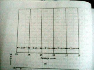
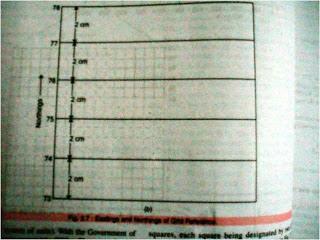
17
while giving a grid reference, Eastings are always stated first, followed by Northings Grid Reference of")
18 i)the readings are always taken to the right of the Eastings and to the North of the Northings. ii)while giving a grid reference, Eastings are always stated first, followed by Northings Grid Reference of this picture is 2676
19 Four Figure Grid Reference:- In fourfigure grid reference, the first two figures are the eastings and the last two are the northings. Six Figure Grid Reference: For greater accuracy, a third figure may be added to two-figure eastings and northings. i) Obtain the four figure reference by using first two digits of eastings and northings. ii)then divide each kilometre into ten parts visually, both vertically & horizontally. iii) Mark the division of eastings and the division of the northing corresponding to the location. iv) The crossing point is the location of the reference point. SCALE
 Scale-2cm:1 km or1:50,000 R.F. or Representative Fraction is the ratio between the distance on the map and the corresponding distance on the ground in the same unit.")
20 Refer to Survey Map No. 45D/7 In the map, 1:50,000 is the R.F. of the map, which means that one unit on the map represents 50,000 units on the ground. For example, 1 cm on the map represents 50,000 cm on the ground. (Scale of this toposheet is) Scale-2cm:1 km or1:50,000 R.F. or Representative Fraction is the ratio between the distance on the map and the corresponding distance on the ground in the same unit. Therefore, R.F.
21 Distance on the map Distance on the ground In the above map, R.F. = 1:50,000 This map is referred to as 1:50,000map and its scale is 2 cm=1km. Representation of Relief on the Map and its Interpretation Earth s surface uneven made up of hills, plains, plateaus, lowland which are varying in their elevation or heights from sea level. The total terrain is also called physical landscape. It can be represented on the maps through different methods, such as spot heights, contouring, etc. Surveying is considered a part of science of map making. Topographical maps are large-scale maps,
22 they show a great deal of details about the relief. In Topographical survey, actual survey is carried out and different methods are used to represent relief on the map as follows. i)hachuring ii)hill shading iii)form lines iv)spot heights v)triangulation points vi)bench markscontours i)hachuring: are short lines representing directions of a slope. - For steep slopes, they are drawn closer together than for the gentle slopes. - on flat grounds they can not be used at all. DISADVANTAGE: it gives no indication of the actual height and that both high plateau region and low plain are unshaded The close hachuring of the high mountain regions tends to obscure other details of the map.
23 II) HILL SHADING: A method of representing relief on a map by depicting the shadows that would be cast by high ground if light were shining from a certain direction. It can be defined as the addition of shadows to give the optical illusion of a third dimension, making hills stand out in relief. The shadows can be regarded as those which would be cast on an imaginary relief model of the ground when illuminated by parallel rays of light from a selected direction or directions. In this map, it is assumed to be from north west at an angle of 45 degree with the horizon. This method too gives a general idea of relief of the country by it does not give the actual height and that it is difficult to know whether a piece of land is sloping uphill or downhill.
24 THE DRAINAGE The term drainage basin describes an area drained collectively by the network of a river along with its tributaries and subtributaries of various dimensions. An area drained by a single river is called its Catchment Area. A drainage system as seen in the topographical sheets usually develops a pattern which is related to the general structure of its basin. 3 distinct patterns can be recognized 1)Dendritic:


25 Dendritic drainage patterns are most common. They develop on a land surface

26 where the underlying rock is of u niform resistance to erosion. Dendritic drainage systems are the most common form of drainage system. The term dendritic comes from the Greekword "dendron", meaning tree, due to the resemblance of the system to a tree. In a dendritic system there is one main river (like the trunk of a tree), which was joined and formed by many smallertributary rivers. They develop where the river channel follows the slope of the terrain. Dendritic systems form in V-shaped valleys; as a result, the rock types must be impervious and non-porous


27 2. TRELLIS Rectangular drainage patterns develop where linear zones of weakness, such as joints or faults cause the streams to cut down along the weak areas in the rock.
28 Trellis systems form in areas of alternating geology, particularly chalk and clay. The main river (the consequent) flows straight down hill. Subsequent streams develop perpendicular to the consequent along softer rock and erode it away, forming vales. The consequent river then cuts through the escarpments of harder rock. Obsequent streams flow down thedip slope of the escarpments to join the subsequent streams. 3. RADIAL
29 Radial drainage patterns develop surrounding areas of high topography where elevation drops from a central high area to surrounding low areas. SIGNIFICANCE OF COLOURS IN TOPOSHEETS On toposheets colours are used to show certain features. Each colour used on a map has significance. 1. BLACK All names, river banks, broken ground, dry streams, surveyed trees, heights and their numbering, railway lines, telephone and telegraph lines, lines of latitude and longitude. 2. BLUE Water features or water bodies that contain water. 3. GREEN All wooded and forested areas, orchards, scattered trees and scrubs.
30 Note:- Prominent surveyed trees are shown in black. Surveyed trees have numbers on their trunks. They serve as landmarks and are not allowed to be cut. 4. YELLOW All cultivated areas are shown with a yellow wash. 5. WHITE PATCHES Uncultivable land 6. BROWN Contour lines, their numbering, form lines, and sand features such as sand hills and dunes. 7. RED Grid lines (eastings and northhings) and their numbering, roads, cart tracks, settlements, huts and buildings. SETTLEMENTS 1. On a topo map, all settlements are shown by symbols in RED colour. 2. The size of the symbol and size and style of letters used give an idea of the size of the settlement. 3. In the case of large cities, major roads are marked and named.
31 4. Deserted village cities, temporarily occupied huts are also shown. 5. Places of worship, forts, water towers, burial grounds, police stations, post office, dak bungalow, circuit houses, etc. are indicated by suitable symbols. NOTE Site is the land on which the settlement (village or town) is built. Dense settlements : Fertile plains and wide river valleys. Sparse Settlements : forests, deserts, mountain slopes, plateaus and hill tops with poor vegetation Absence of Settlements: Swamps, marsh land, sandy deserts, thick impenetrable forests, flood-prone areas, steep mountain slopes. OCCUPATION AND MAP FEATURES AGRICULTURE Level land with yellow wash; many wells LUMBERING: Forests
32 CATTLE REARING Pastures, meadows, grasslands, presence of road in highland region (sheep) FISHING Plenty of rivers MINING Stony wastes, quaries, limestone beds TRADE Dense settlements near road INDUSTRY Large settlements near roads and railways, presence of raw materials, (like making, cement industry near limestone beds) TOURISM hotels and inns APPROXIMATE OR RELATIVE HEIGHT-is height is not taken from sea level but with respect to the surrounding area. It may be the height of a dam, bridge, sand dune or it can be the depth of a well, tank, hill or river canal, for example, 3r, 5r, 8r, etc. EXAMPLE:3r - the relative depth of perennial lined well in 3 metres
33 5r the relative height of dry tank is 5 metres NOTE: CHECK THE SYMBOL if it is tank, dam, bridge, embankment, etc then write the answer this way - the relative height of... is...meters.
Topographical Maps ANSWER KEY- Assignment 6
 Topographical Maps ANSWER KEY- Assignment 6 Question 1 (To be answered using toposheet 45 D/7, Grid reference 76 to 85) 1. Cite two differences between the Sipu River and the Mahadeviyo Nala? Sipu River
DOWNLOAD PDF THE GEOGRAPHICAL INTERPRETATION OF TOPOGRAPHICAL MAPS.
 Chapter 1 : Topography - Wikipedia â Topographical maps are large-scale maps, they show a great deal of details about the relief. â In Topographical survey, actual survey is carried out and different methods
B. Topographic maps are also called. contour maps
 Topographic Maps Introduction A. Topographic maps are essential tools in geologic and engineering studies because they show the configuration of Earth's surface in remarkable detail and permit one to measure
Topographic Maps. Take Notes as you view the slides
 Topographic Maps Take Notes as you view the slides Lesson Objectives Define a topographic map and state its uses. Describe how contour lines show the elevations, shape, and slope of the land. Identify
MAP STUDY: INTERPRETATION OF SURVEY MAPS
 MAP STUDY: INTERPRETATION OF SURVEY MAPS Types and Elements of Maps Maps are drawn to represent the Earth on a piece of paper. Maps are used widely to represent the Earth. Maps use signs and symbols in
Terrain Analysis through Maps.
 Terrain Analysis through Maps Need for Maps Theodolite Every Inch on Earth is Measured Maps are Prepared based on these Measurements Classification of Maps Function Scale Physical (Natural Features)
Notes and Summary pages:
 Topographic Mapping 8.9C Interpret topographical maps and satellite views to identify land and erosional features and predict how these shapes may be reshaped by weathering ATL Skills: Communication taking
Map reading notes. It is a very useful kind of map that shows the topography of an area, i.e whether it is flat, undulating, rugged or mountainous
 Introduction Map reading notes In the course of 2 or 3 years course, Candidates will be exposed to topographical maps from tropical countries such as Mauritius, Tanzania, Zimbabwe and Jamaica. Many of
Using Map and Compass Together
 Using Map and Compass Together In situations where you foresee a potential evacuation on foot, where there are no roads, and no indication as to the direction of travel (i.e., road signs), it is recommended
MAPPING THE EARTH HOW DO YOU FIND A LOCATION ON THE EARTH?
 MAPPING THE EARTH HOW DO YOU FIND A LOCATION ON THE EARTH? UNIT TOPICS TOPIC 1: LATITUDE & LONGITUDE TOPIC 2: FIELD MAPS TOPIC 3: TOPOGRAPHIC MAPS TOPIC 4: NYS LANDSCAPES TOPIC 1: LATITUDE & LONGITUDE
Why study physical features? How does it help me during the course of studying Geography Elective?
 (b) Physical features Why study physical features? How does it help me during the course of studying Geography Elective? Physical factors influence the distribution of agricultural systems. Some factors
Different types of maps and how to read them.
 Different types of maps and how to read them. A map is a picture or representation of the Earth's surface, showing how things are related to each other by distance, direction, and size. Maps have been
Laboratory Exercise #2 Introduction to Quadrangle Maps
 page - Laboratory Exercise #2 Introduction to Quadrangle Maps A. Introduction to Quadrangle Maps The United States Geological Survey has developed a nationwide series of quadrangle maps that cover small
MILITARY TOPOGRAPHIC MAP II B170247XQ STUDENT HANDOUT
 UNITED STATES MARINE CORPS THE BASIC SCHOOL MARINE CORPS TRAINING COMMAND CAMP BARRETT, VIRGINIA 22134-5019 MILITARY TOPOGRAPHIC MAP II B170247XQ STUDENT HANDOUT Basic Officer Course Introduction Importance
Topographic Map Series:
 DEFINITION OF A MAP A MAP IS A GEOGRAPHIC PREPRESENTATION OF A PORTION OF THE EARTH S SURFACE DRAWN TO SCALE, AS SEEN FROM ABOVE. IT S USES COLORS, SYMBOLS AND LABELS TO REPRESENT FEATURES FOUND ON THE
AS 410 Land Navigation. Chpt 4-1
 AS 410 Land Navigation Chpt 4-1 Overview Types of Maps Map Legends / Scales Latitude and Longitude Orienteering Why? Why important to learn how to read a compass and map? No cell phone coverage Mountain
REVISION: MAPWORK 18 SEPTEMBER 2014
 REVISION: MAPWORK 18 SEPTEMBER 2014 Lesson Description In this lesson we revise: Various mapwork calculations Summary Relative Position Bearing is the angular (angle) distance between two points True Bearing
Topographic Maps. More than a Road Map
 Topographic Maps More than a Road Map What is a Topographic Map? Scaled representation of features on the surface of the Earth such as roads, rivers, and plains Provides information about land elevations
Laboratory Exercise #2 Introduction to Quadrangle Maps
 page - 1 Laboratory Exercise #2 Introduction to Quadrangle Maps A. Introduction to Quadrangle Maps The United States Geological Survey has developed a nationwide series of quadrangle maps that cover small
Topographical Maps ANSWER KEY- Assignment 2. Question 1 (To be answered using toposheet 45 D/7, Grid reference 76 to 85)
") Topographical Maps ANSWER KEY- Assignment 2 Question 1 (To be answered using toposheet 45 D/7, Grid reference 76 to 85) a. Gonodra 8292 b. Ganeshpura. 8089 a. Well in Agdol 764892 / 765893 b. Temple south-east
Topographical Maps ANSWER KEY- Assignment 2 Question 1 (To be answered using toposheet 45 D/7, Grid reference 76 to 85) a. Gonodra 8292 b. Ganeshpura. 8089 a. Well in Agdol 764892 / 765893 b. Temple south-east
APPENDIX A GLOSSARY. Appendix A.1
 APPENDIX A GLOSSARY Appendix A.1 Appendix A.2 Back Bearing A back bearing is measured from the object to your position. It is the exact opposite of a direct bearing. Base Line An imaginary line on the
Downloaded from
 SOCIAL STUDIESCLASS - V LESSON-1 GLOBE ANSWER THE FOLLOWING: 1. Name the continents and oceans on the earth. Ans. The seven continents are: a) Australia b) Europe c) Antarctica d) South America e) North
Earth Science. STREAM DRAINAGE PATTERNS (start by reading the first page of these notes!)
") Name _ Earth Science STREAM DRAINAGE PATTERNS (start by reading the first page of these notes!) WHAT IS A DRAINAGE PATTERN? Streams seek the lowest path as they move downhill, and they tend to erode their
Name _ Earth Science STREAM DRAINAGE PATTERNS (start by reading the first page of these notes!) WHAT IS A DRAINAGE PATTERN? Streams seek the lowest path as they move downhill, and they tend to erode their
Chapter 3 Models of the Earth. 3.1 Finding Locations on the Earth. 3.1 Objectives
 Chapter 3 Models of the Earth 3.1 Finding Locations on the Earth 3.1 Objectives Explain latitude and longitude. How can latitude and longitude be used to find locations on Earth? How can a magnetic compass
ORIENTEERING. The challenge is to use the map to decide the best route to complete the course in the quickest time. Orienteering Map. Compass.
 ORIENTEERING Orienteering is similar to a cross-country race but you navigate using a map instead of following a set course. It is an outdoor sport where competitors navigate their own way, you can run,
What is a map? A Map is a two or three-dimensional model or representation of the Earth s surface. 2-Dimensional map
 What is a map? A Map is a two or three-dimensional model or representation of the Earth s surface. 2-Dimensional map What is a Map Projection? Planar Projection Projection A Projection is a mathematical
Mapping Earth. How are Earth s surface features measured and modeled?
 Name Mapping Earth How are Earth s surface features measured and modeled? Before You Read Before you read the chapter, think about what you know about maps Record your thoughts in the first column Pair
Lab Topographic Maps. Name: Partner: Purpose. Background Information
 Lab Topographic Maps Name: Partner: Purpose The purpose of this lab is to familiarize you with graphic representations of the Earth s surface primarily maps. Simple line maps show the spatial relationship
Erosional Features. What processes shaped this landscape?
 Have you ever looked at the land around you and wondered what processes shaped what you see? Perhaps you see mountains, valleys, rivers, or canyons. Do you know how long these geologic features have been
56H. This system allows definition of points on the Earth s surface to within 100 meters. Page 20. Navigation Systems Basics of Maps
 Grid References Many maps are provided with the standard grid overlaying them. This provides a simple and accurate method for finding features on the map. It is a network of intersecting parallel lines
Topographic Maps and Landforms Geology Lab
 Topographic Maps and Landforms Geology Lab Ray Rector: Instructor Today s Lab Activities 1) Discussion of Last Week s Lab 2) Lecture on Topo Maps and Elevation Contours 3) Construct Topographic Maps and
Chapter 1 Overview of Maps
 Chapter 1 Overview of Maps In this chapter you will learn about: Key points when working with maps General types of maps Incident specific maps Map legend and symbols Map sources A map is a navigational
Navigating for Scouts A Self-teaching Guide to Navigation with Map and Compass
 Don Burgess, November 2003 Materials topographic maps Navigating for Scouts A Self-teaching Guide to Navigation with Map and Compass metric ruler orienteering compass 30 M/5 Hamilton-Burlington 41 I/13
data becomes available to us. We already have crude maps of the Mars and the Moon. A map gives a picture of one or several of the elements of the
 FUNDAMENTALS OF MAPS THE SPHERICAL earth is best represented bya three-dimensional model of the earth, called a globe. All parts of the earth can be shown on it in their true shape, area and location along
EROSIONAL FEATURES. reflect
 reflect Have you ever looked at the land around you and wondered what processes shaped what you see? Perhaps you see mountains, valleys, rivers, or canyons. Do you know how long these geologic features
LESSON 2: INTRODUCTION TO TOPOGRAPHICAL MAPS
 LESSON 2: INTRODUCTION TO TOPOGRAPHICAL MAPS Finding your way if you become separated from a group. PURPOSE This lesson presents an overview of topographic maps. It describes their characteristics and
Latitude and Longitude
 U n i t 3 M a p p i n g P a g e 1 Latitude and Longitude Note: These coordinates are always expressed LATITUDE/LONGITUDE!!! Coordinate System: Using and to find your position on Earth. LATITUDE LATITUDE
Map reading made easy
 Map reading made easy 1. What is a map? A map is simply a drawing or picture (in 2-D) of a landscape or area of a country (in 3-D). It could be anything from a sketch map for a visitor to find your school
Elevations are in meters above mean sea level. Scale 1:2000
 12.001 LAB 7: TOPOGRAPHIC MAPS Due: Monday, April 11 PART I: CONTOURING AND PROFILES (20 PTS) 1. Contour this area map using a 5 meter contour interval. Remember some fundamental rules of contour lines,
Map reading made easy
 Map reading made easy Maps can be great fun and they can lead you to all sorts of discoveries. They can help you get to know an area really well, because they pinpoint interesting places that are often
GDC MEMORIAL COLLEGE BAHAL (BHIWANI)
") GDC MEMORIAL COLLEGE BAHAL (BHIWANI)-127028 Lab Manual Geography (B.A 1 st Semester) Department of Geography Content 1. Cartography 2. Maps and their types 3. Map scale 3.1 Methods of expressing a scale
GDC MEMORIAL COLLEGE BAHAL (BHIWANI)-127028 Lab Manual Geography (B.A 1 st Semester) Department of Geography Content 1. Cartography 2. Maps and their types 3. Map scale 3.1 Methods of expressing a scale
Chapter 3 SECTION 1 OBJECTIVES
 Chapter 3 SECTION 1 OBJECTIVES Distinguish between latitude and longitude and locate coordinates on maps. Explain how latitude and longitude can be used to locate places on Earth s surface. Explain the
Geology 101 Lab Worksheet: Topographic Maps
 Geology 101 Lab Worksheet: Topographic Maps Name: Refer to the Topographic Maps Lab for the information you need to complete this worksheet (http://commons.wvc.edu/rdawes/g101ocl/labs/topomapslab.html).
Name Date Class. a. High elevation and high relief b. High elevation and level surface c. Flat land and low relief
 Exploring Earth s Surface (pp. 21 27) This section describes factors that determine the shape of Earth s land surface. The section also describes how scientists divide Earth into four spheres. Use Target
What is a map? Understanding your map needs
 What is a map? A map is simply a drawing or picture of a landscape or location. Maps usually show the landscape as it would be seen from above, looking directly down. As well as showing the landscape of
HWA CHONG INSTITUTION NATIONAL POLICE CADET CORPS TOPOGRAPHY AND ORIENTEERING. Topography and Orienteering
 Topography and Orienteering 1. Introduction Orienteering is about using a topographic map and compass to find points in the landscape. It is fun and challenging, as one would need to take reference to
iv vi x Using maps 2 Using images and analysing data 6 Using new technologies in geography 8
 Contents Exam board specification map Introduction Topic checker iv vi x Geographical skills Using maps 2 Using images and analysing data 6 Using new technologies in geography 8 Natural hazards Tectonic
International Journal of Modern Trends in Engineering and Research e-issn No.: , Date: April, 2016
 International Journal of Modern Trends in Engineering and Research www.ijmter.com e-issn No.:2349-9745, Date: 28-30 April, 2016 Landslide Hazard Management Maps for Settlements in Yelwandi River Basin,
Map reading made easy
 Map reading made easy 1 1. What is a map? A map is simply a drawing or picture (in 2-D) of a landscape or area of a country (in 3-D). It could be anything from a sketch map for a visitor to find your school
Science EOG Review: Landforms
 Mathematician Science EOG Review: Landforms Vocabulary Definition Term canyon deep, large, V- shaped valley formed by a river over millions of years of erosion; sometimes called gorges (example: Linville
USING THE MILITARY LENSATIC COMPASS
 USING THE MILITARY LENSATIC COMPASS WARNING This presentation is intended as a quick summary, and not a comprehensive resource. If you want to learn Land Navigation in detail, either buy a book; or get
Chapter 6 Mapping and Online Tools
 Chapter 6 Mapping and Online Tools The stream site you monitor is just part of a much larger system. When analyzing stream health, it is important to take a holistic view by considering the entire watershed.
Class Notes: Mapping the Earth
 Name: Date: Period: Mapping the Earth The Physical Setting: Earth Science Class Notes: Mapping the Earth I. Latitude and Longitude Map -! Latitude -! Also called These lines intersect Equator -! The North
Geography Class XI Fundamentals of Physical Geography Section A Total Periods : 140 Total Marks : 70. Periods Topic Subject Matter Geographical Skills
 Geography Class XI Fundamentals of Physical Geography Section A Total Periods : 140 Total Marks : 70 Sr. No. 01 Periods Topic Subject Matter Geographical Skills Nature and Scope Definition, nature, i)
Topo Map Tidbits. Adapted from: An original Creek Connections activity. Creek Connections, Box 10, Allegheny College, Meadville, Pennsylvania, 16335
 Topo Map Tidbits Adapted from: An original Creek Connections activity. Creek Connections, Box 10, Allegheny College, Meadville, Pennsylvania, 16335 Introduction to Topographic Maps Grade Level: Basic Duration:
ENGRG Introduction to GIS
 ENGRG 59910 Introduction to GIS Michael Piasecki March 17, 2014 Lecture 08: Terrain Analysis Outline: Terrain Analysis Earth Surface Representation Contour TIN Mass Points Digital Elevation Models Slope
Landscape evolution. An Anthropic landscape is the landscape modified by humans for their activities and life
 Landforms Landscape evolution A Natural landscape is the original landscape that exists before it is acted upon by human culture. An Anthropic landscape is the landscape modified by humans for their activities
Laboratory Exercise #4 Geologic Surface Processes in Dry Lands
 Page - 1 Laboratory Exercise #4 Geologic Surface Processes in Dry Lands Section A Overview of Lands with Dry Climates The definition of a dry climate is tied to an understanding of the hydrologic cycle
Mapping Earth. Technology and Mapmaking
 CHAPTER 1 LESSON 2 Mapping Earth Technology and Mapmaking Key Concepts What can a topographic map tell you about the shape of Earth s surface? What can you learn from geologic maps about the rocks near
Name: Mid-Year Review #2 SAR
 Name: Mid-Year Review #2 SAR Base your answers to questions 1 through 3 on on the diagram below, which shows laboratory materials used for an investigation of the effects of sediment size on permeability,
Cambridge International Examinations Cambridge International General Certificate of Secondary Education
 Cambridge International Examinations Cambridge International General Certificate of Secondary Education *7611817912* GEOGRAPHY 0460/21 Paper 2 May/June 2015 Candidates answer on the Question Paper. Additional
(Hint: You must always back up map work questions with evidence from the map e.g. grid references.)
") Map Work Revision Notes (Hint: You must always back up map work questions with evidence from the map e.g. grid references.) Scale Scale is the ratio between a distance on a map and the corresponding distance
Map Work Revision Notes (Hint: You must always back up map work questions with evidence from the map e.g. grid references.) Scale Scale is the ratio between a distance on a map and the corresponding distance
Unit 1: Geography. For additional information, refer to this website: 1 G e o g r a p h y
 Unit 1: Geography For additional information, refer to this website: http://mryoungtms.weebly.com/ 1 G e o g r a p h y Continents and Oceans SOL USI. 2a Essential Understanding: Continents are large land
Characteristics and processes associated with the development of Hilly Landscapes
 GRADE 11 GEOGRAPHY SESSION 1: GEOMORPHOLOGY I (TOPOGRAPHY) Key Concepts In this lesson we will focus on summarising what you need to know about: Topography associated with Horizontally Layered Rocks Topography
NEW YORK S NATURAL WONDERS
 Landscapes and Drainage Patterns NEW YORK S NATURAL WONDERS New York is not one of the largest states of the United States, nor does it have any large national parks to rival Yosemite or the Grand Canyon.
SESSION 6: FLUVIAL LANDFORMS
 SESSION 6: FLUVIAL LANDFORMS KEY CONCEPTS: Fluvial Landforms Management of River Catchment Areas Slope Elements X-PLANATION: FLUVIAL LANDFORMS Rivers form landforms as they erode the landscape. These landforms
Unit 1: Basics of Geography Test Review
 Name Date Period Unit 1: Basics of Geography Test Review Directions: Reading the following sections and complete the questions, charts, and diagrams. Types of Maps Maps that have a particular theme are
APPENDIX F PRE-COURSE WORK
 APPENDIX F PRE-COURSE WORK F-1 Pre-Course Work F-2 Pre-Course Work Intermediate Wildland Fire Behavior, S-290 Pre-Course Work The pre-course work is designed to ensure that students come to class with
1/28/16. EGM101 Skills Toolbox. Map types. Political Physical Topographic Climate Resource Road. Thematic maps (use one of the above as backdrop)
") EGM101 Skills Toolbox Map types Political Physical Topographic Climate Resource Road Thematic maps (use one of the above as backdrop) Map Types Deriving information from maps Hydrographic Geological Soils
EGM101 Skills Toolbox Map types Political Physical Topographic Climate Resource Road Thematic maps (use one of the above as backdrop) Map Types Deriving information from maps Hydrographic Geological Soils
GEOGRAPHY: PAPER II MARKING GUIDELINES
 GRADE 11 EXAMINATION NOVEMBER 2007 GEOGRAPHY: PAPER II MARKING GUIDELINES Time: 1½ hours 100 marks The marking guide is a working document prepared for use by teachers as they assess the Grade 11 externally
mountain rivers fixed channel boundaries (bedrock banks and bed) high transport capacity low storage input output
 high transport capacity low storage input output") mountain rivers fixed channel boundaries (bedrock banks and bed) high transport capacity low storage input output strong interaction between streams & hillslopes Sediment Budgets for Mountain Rivers Little
mountain rivers fixed channel boundaries (bedrock banks and bed) high transport capacity low storage input output strong interaction between streams & hillslopes Sediment Budgets for Mountain Rivers Little
About places and/or important events Landmarks Maps How the land is, hills or flat or mountain range Connected to maps World Different countries
 What do you think you know about geography? About places and/or important events Landmarks Maps How the land is, hills or flat or mountain range Connected to maps World Different countries What do you
UNIT 1C. USING TOPOGRAPHIC MAPS WHERE IN THE WORLD... ARE YOU?
 UNIT 1C. USING TOPOGRAPHIC MAPS WHERE IN THE WORLD... ARE YOU? TIME 60-90 minutes LEVEL All BENCHMARKS Next Generation Science Standards MS-LS1.D Science & Engineering Practices Developing and Using Models
ENGRG Introduction to GIS
 ENGRG 59910 Introduction to GIS Michael Piasecki November 17, 2017 Lecture 11: Terrain Analysis Outline: Terrain Analysis Earth Surface Representation Contour TIN Mass Points Digital Elevation Models Slope
CONTOUR MAPS This Enrichment4You e-guide provides a brief overview of contour maps In this e-guide you will: Sample file
 GEOLOGY CONTOUR MAPS CONTOUR MAPS This Enrichment4You e-guide provides a brief overview of contour maps In this e-guide you will: *Learn Basic Facts About Contour Maps *Make a 3-D Contour Map Geology Contour
1. Origins of Geography
 II. ORIGINS AND BRANCHES OF GEOGRAPHY My Notes A. Origins of Geography Unit One 6 Before carefully examining the tools of the geographer, it would be useful to examine the origins and roots of this ancient
Compass Basics. Quick Map Basics Review For Compass Use
 Compass Basics Quick Map Basics Review For Compass Use A topographic map tells you where things are and how to get to them, whether you're hiking, biking, hunting, fishing, or just interested in the world
GEOGRAPHY: PAPER II. 1. Write your examination number in the appropriate blocks provided above.
 NATIONAL SENIOR CERTIFICATE EXAMINATION NOVEMBER 2014 GEOGRAPHY: PAPER II EXAMINATION NUMBER Time: 1½ hours 100 marks PLEASE READ THE FOLLOWING INSTRUCTIONS CAREFULLY 1. Write your examination number in
Map Reading & Compass Use
 Spring 2013 Kestrel Land Trust Page 2 / 10 Contents Map Basics... 3 Map Types... 3 Terrain Association... 4 Estimating Distance: Pacing... 4 Contour Lines... 5 Navigating with a Compass... 6 Compass Types...
Introduction to Cartography Part I
 Introduction to Cartography Part I Introduction to Cartography Maps vs. Globes General Types of Maps Standard Map Features Maps versus Globes Map: a representation of the world, or part of it, in two dimensions
Wonder as you Wander up the Carding Mill Valley
 Wonder as you Wander up the Carding Mill Valley Spot clues to the 600 million year old history of the Long Mynd. Consider how the Earth has evolved since the rock you are walking over first formed. Welcome
Erosion Surface Water. moving, transporting, and depositing sediment.
 + Erosion Surface Water moving, transporting, and depositing sediment. + Surface Water 2 Water from rainfall can hit Earth s surface and do a number of things: Slowly soak into the ground: Infiltration
Topographic Maps Self-Instruction Lab (2016 edition) Geology 100 David Harbor s Section. 12 inches x 1 mile
 Geology 100 David Harbor s Section. 12 inches x 1 mile") Topographic Maps Name Self-Instruction Lab (2016 edition) Geology 100 David Harbor s Section Topographic maps are an important aid for a geologist, but maps are also useful for hikers, bicyclists, and
Topographic Maps Name Self-Instruction Lab (2016 edition) Geology 100 David Harbor s Section Topographic maps are an important aid for a geologist, but maps are also useful for hikers, bicyclists, and
Geography Knowledge Organiser: What is a Geographer?
 Geography Knowledge Organiser: What is a Geographer? KPI 7.1.1 Locate and name the continents and oceans of the world, identify characteristics of the four countries and capital cities of the United Kingdom
OUR COUNTRY INDIA LOCATIONAL SETTING
 7 India is a country of vast geographical expanse. In the north, it is bound by the lofty Himalayas. The Arabian Sea in the west, the Bay of Bengal in the east and the Indian Ocean in the south, wash the
Changes in Texas Ecoregions
 Comment On Lesson Changes in Texas Ecoregions The state of Texas can be divided into 10 distinct areas based on unique combinations of vegetation, topography, landforms, wildlife, soil, rock, climate,
The City School. Pakistan Studies 2059/02 Paper 2 The Environment of Pakistan Class 9
 The City School Prep + Senior -1Section Pakistan Studies 2059/02 Paper 2 The Environment of Pakistan Class 9 Name: Class: The City School /PAF Chapter / Prep + Senior I Section / Worksheet for Intervention
Complete Geography Overview: Year 1 to Year 6
 Option 1 Complete Geography Overview: Year 1 to Year 6 Autumn Term Spring Term Summer Term Year 1 Where do I live? Around the World The Four Seasons Year 2 At the Farm Let s go on Safari My World and Me
Unit 1: Mapping and Astronomy
 Unit 1: Mapping and Astronomy 1 Do Now In your notebook, write your thoughts on the following: -What do you know about the beginning location and trajectory of the most recent hurricanes (Harvey or Irma)?
The Tacoma Mountaineers Wilderness Navigation
 The Tacoma Mountaineers Wilderness Navigation Navigation Fundamentals Navigation in mountainous terrain and wilderness areas requires a set of skills, of which using a map and compass is only one part.
Report for Area Drainage Studies for 1320 MW (2x660 MW) THERMAL POWER PROJECT AT MIRZAPUR, U.P.
 THERMAL POWER PROJECT AT MIRZAPUR, U.P.") Report for Area Drainage Studies for 1320 MW (2x660 MW) THERMAL POWER PROJECT AT MIRZAPUR, U.P. 1. Introduction M/s Welspun Energy Uttar Pradesh Ltd. (WEUPL) is putting up 1320 MW (2 x 660 MW) coal fired
Report for Area Drainage Studies for 1320 MW (2x660 MW) THERMAL POWER PROJECT AT MIRZAPUR, U.P. 1. Introduction M/s Welspun Energy Uttar Pradesh Ltd. (WEUPL) is putting up 1320 MW (2 x 660 MW) coal fired
Maps: Geography s Basic Tools
 Maps: Geography s Basic Tools What is a map? - A map is a representation of the earth s features drawn on a flat surface. - Maps use points, lines, colours, and symbols to represent the features of an
CHAPTER EXIT CHAPTER. Models of Earth. 3.1 Modeling the Planet. 3.2 Mapmaking and Technology. 3.3 Topographic Maps CHAPTER OUTLINE
 EXIT CHAPTER.1 Modeling the Planet.2 Mapmaking and Technology. Topographic Maps CHAPTER OUTLINE CHAPTER.1 Modeling the Planet A flat of Earth is a convenient tool, but it can distort the shape, distance,
New National Curriculum Geography Skills Planning KS1
 New National Curriculum Geography Skills Planning KS1 Enquiry Question Objective-essential knowledge skills or understanding Locational Knowledge Standards /Success Criteria Lesson progression over half
Landforms. Why does the land look like it does? 1. Controlled by water 2. Controlled by the rocks
 Landforms Why does the land look like it does? 1. Controlled by water 2. Controlled by the rocks Landforms Made by Running Water Stream erosion The evolution of a river system Entrenched meanders Fluvial
Extra Credit Assignment (Chapters 4, 5, 6, and 10)
") GEOLOGY 306 Laboratory Instructor: TERRY J. BOROUGHS NAME: Extra Credit Assignment (Chapters 4, 5, 6, and 10) For this assignment you will require: a calculator and metric ruler. Chapter 4 Objectives:
GEOLOGY 306 Laboratory Instructor: TERRY J. BOROUGHS NAME: Extra Credit Assignment (Chapters 4, 5, 6, and 10) For this assignment you will require: a calculator and metric ruler. Chapter 4 Objectives:
In order to be adequately prepared for a test on this topic you should be able to:-
 Topic 2: MAPPING In order to be adequately prepared for a test on this topic you should be able to:- 1. Find and also provide both FOUR and SIX figure Area and Grid References 2. Calculate distances both
Geography and Earth Science. Unit 5
 Geography and Earth Science Unit 5 Chapter 1 Map Skills Lesson 2 Introduction to Maps Key Terms What You Will Learn to Do Use map reading skills bar scale contrast elevation intermittent landforms legend
Surface Water and Stream Development
 Surface Water and Stream Development Surface Water The moment a raindrop falls to earth it begins its return to the sea. Once water reaches Earth s surface it may evaporate back into the atmosphere, soak
STAAR Science Tutorial 40 TEK 8.9C: Topographic Maps & Erosional Landforms
 Name: Teacher: Pd. Date: STAAR Science Tutorial 40 TEK 8.9C: Topographic Maps & Erosional Landforms TEK 8.9C: Interpret topographic maps and satellite views to identify land and erosional features and