Physical Geography of China and Mongolia
|
|
|
- Vernon Cunningham
- 5 years ago
- Views:
Transcription
1 East Asia
2 China and Mongolia
3 Physical Geography of China and Mongolia
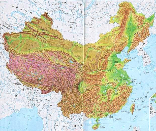
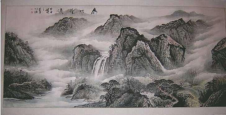
4 Physical Geography of China Landforms China can be divided into two parts: the mountains and plateaus of the west, and the plains and hills of the east. The east contains the majority of the population, as the land is conducive to farming. The mountainous barriers of the west kept China isolated for millennia. The Gobi desert, in north-central China, is the source of frequent dust storms in the region. The Himalaya separate China from South Asia.
5
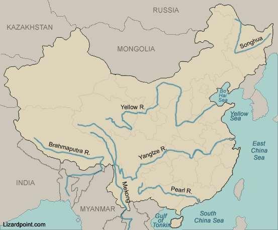
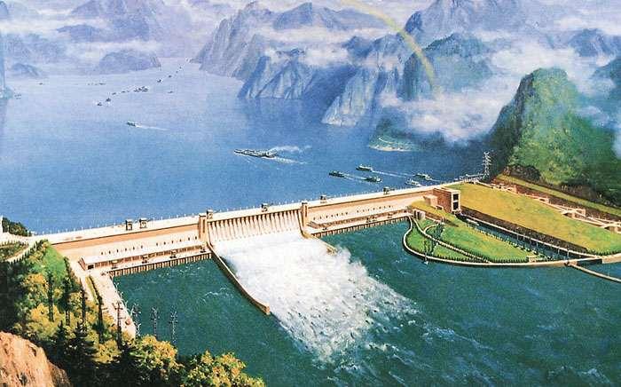
6 Physical Geography of China Water Systems The Plateau of Tibet is the source of China s major rivers that flow eastward toward the Pacific Ocean. The Huang He (Yellow River) is filled with loess, a fine, nutrient-rich topsoil that makes the North China Plain ideal for farming. The Chang Jiang (Yangtze River) is a major transportation route and home to the Three Gorges Dam. The Xi (Pearl River) serves rapidly developing areas in China, like the port of Guangzhou.
7
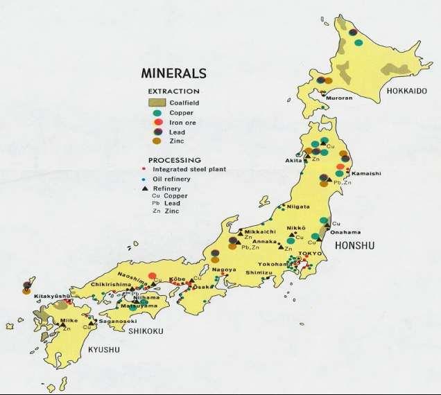
8 Physical Geography of China Climates, Biomes, and Resources Climates are extremely diverse, ranging from tropical in the south to subarctic in the north. The monsoons, or seasonal winds, direct the weather patterns of China. Typhoons, large violent storms, threaten the region between August and late October. China has a wealth of mineral resources and vast petroleum reserves. Not only the world s top producer of rice, China leads in farm output of many crops.

9
10 Physical Geography of China Stop and Jot: Answer the following questions on a sheet of paper. Will turn in at end of class. 1. Where do most people live in China(N,S,E,W)? Why? 2. What major river is used for both transportation and hydroelectric power? (3 Gorges Dam) 3. What does China have vast reserves of (resource)?
11
12 Human Geography of China
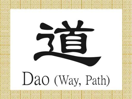
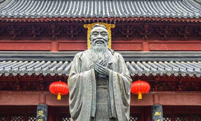
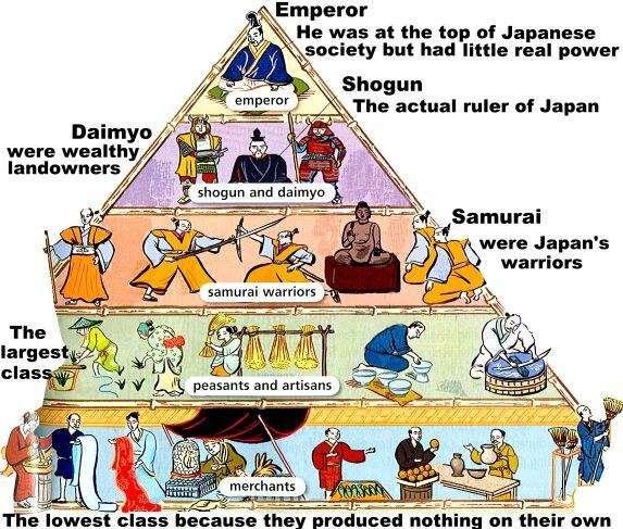
13 Human Geography of China History and Government Dynasties, or ruling families, were believed to rule under the Mandate of Heaven, or approval from the gods. Confucius (Kongfuzi), China s most famous teacher and philosopher, founded an ideology based on discipline and proper moral conduct. Daoism is still practiced today and stresses harmony with nature and simple living. The Communists took power in China in 1949, but Taiwan and Mongolia are more democratic.
14
15 Human Geography of China History and Government Stop and Jot: 1. What is another name for Ruling Families? 2. What religion encourages harmony with nature and simple living?
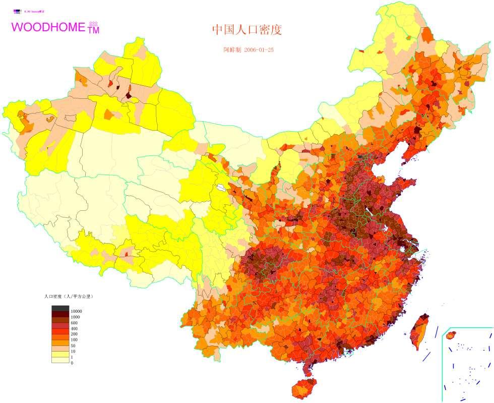
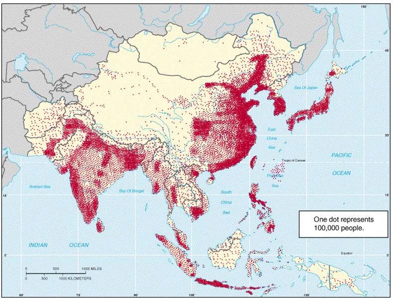
16 Human Geography of China Population Patterns The Ethnic Han Chinese comprise 92 percent of the population of China and speak Mandarin. 90 percent of China s population lives on onesixth of the land. Mongolia s population is primarily ethnic Mongolian and has a low population density. Urban migration is rapidly increasing in China. China s one-child policy has reduced the growth rate but also causes problems.
17
18 Human Geography of China Population Patterns Stop and Jot: 3. What ethnic group are most Chinese people? What language do they speak? 4. What policy has slowed population growth in China?
19 Human Geography of China Society and Culture Today The government has promoted efforts to increase literacy across all social strata. The government exerts power over religious and personal freedoms. China s rich artistic heritage of poetry, porcelain, and opera are experiencing a resurgence. The family is the most important social unit. The one-child rule, along with the preference for boys, has resulted in the death of many female infants through purposeful neglect.

20
21 Human Geography of China Society and Culture Today Stop and Jot: 5. What controls religious and personal freedoms in China? 6. What is the most important social unit in China?
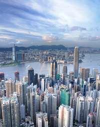
22 Human Geography of China Economic Activities China s large agricultural workforce produces the most rice, wheat, and tea worldwide. China is the world s largest exporter and uses its undervalued Yuan to keep export prices down. Human rights issues are a troubling concern, as those who speak out are treated harshly. Former British colony Hong Kong is in a Special Economic Zone, meaning it welcomes foreign investment with minimal governmental interference.
23
24 Human Geography of China Economic Activities Stop and Jot: 7. What is China the world s largest producer of? 8. What human rights are being threatened in China?
25 People and their Environment: China
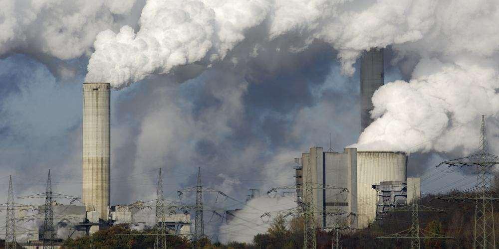
26 People and Their Environment: China Managing Resources Meeting the demand for more electric power has become a pressing issue and has led to the creation of the Three Gorges Dam. The dam has endangered many plants and animals, and caused some to go extinct. China burns fossil fuels as its primary source of power, resulting in massive pollution. China has plans to build nuclear power plants in the future.
27
28 People and Their Environment: China Managing Resources Stop and Jot: 1. Why was the Three Gorges Dam built? 2. What has led to massive air pollution in China?
29 People and Their Environment: China Human Impact Globalization now exerts a greater influence on Chinese life than it ever has before. Suppressed before the late 1970s, the loosening of government control has resulted in the rise of regional identities. The Guangdong region where Hong Kong is located is the main gateway for foreign influence. Power in East Asia has shifted to China, worrying its neighbors and others worldwide.
30
31 People and Their Environment: China Human Impact Stop and Jot: 3. What worries China s neighbors? 4. What has happened to governmental control since the late 1970s? What has this led to?
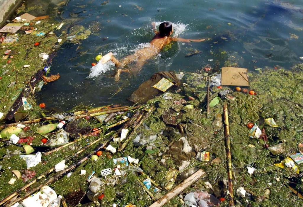
32 People and Their Environment: China Addressing the Issues Economic growth has created great benefits, but also severe environmental problems. Urban areas are plagued by severe pollution. Clean water is a problem, with 70 percent of China s lakes and rivers polluted. Pollution has made cancer the leading killer in China. The overwhelming focus on economic growth has led national and local governments to ignore protective regulation.
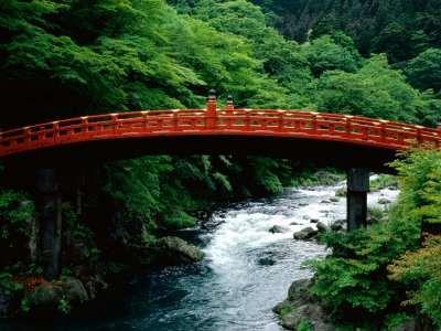
33
34 People and Their Environment: China Addressing the Issues Stop and Jot: 3. How has economic growth not been a good thing? 4. What percentage of China s lakes and rivers are polluted?
35 Japan
36 Physical Geography of Japan
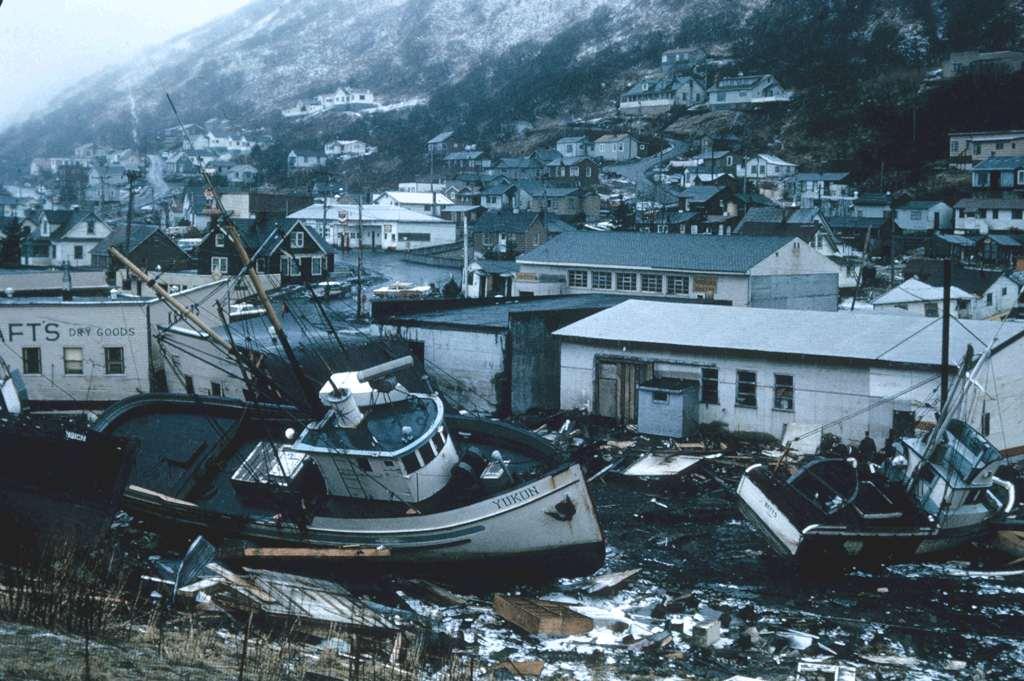
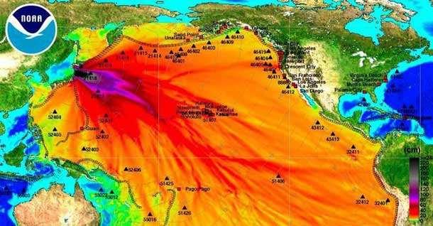
37 Physical Geography of Japan Landforms Although there are 6,800 islands in its archipelago, a group or chain of islands, Japan consists of four main islands: Hokkaidō, Honshū, Shikoku, and Kyūshū. Most Japanese live along the coastal lowlands. Japan s location in the Ring of Fire results in volcanic activity and frequent earthquakes. When earthquakes occur, a major tsunami, or huge wave, can form, causing massive property damage and many casualties.
38
39 Physical Geography of Japan Landforms STOP AND JOT: 1. Where do most Japanese live? Why? 2. What is an Archipelago?
40 Physical Geography of Japan Water Systems Japan has short, swift rivers that flow from the mountains and plunge over cliffs, often as stunning waterfalls. Japanese rivers cross alluvial plains before emptying into the sea. Increasing demand for water by industry and agriculture remains a challenge. Many of Japan s coastal lakes were formed when river valleys became dammed by silt or sandbars.
41
42 Physical Geography of Japan Water Systems STOP AND JOT: 3. What resource is at risk because of increased agriculture and industry? 4. What caused coastal lakes to develop?
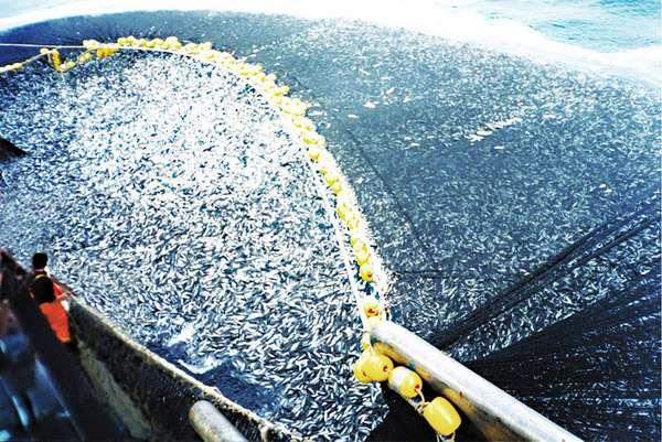
43 Physical Geography of Japan Climates, Biomes, and Resources Overall, Japan has a mild climate with abundant rainfall. The northern latitudes experience a humid continental climate, while further south is a humid, subtropical climate. Most of Japan is forested, and large land mammals and birds still thrive in isolated mountain regions. As an island nation, Japan relies heavily on the sea for food, but is also a leading rice producer.
44
45 Physical Geography of Japan Climates, Biomes, and Resources STOP AND JOT: 5. What do most people rely on for food? 6. How has isolation impacted the plant and wildlife in Japan?
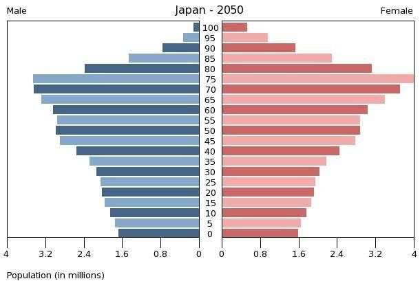
46 Human Geography of Japan
47 Human Geography of Japan History and Government China and Korea influenced early Japan. In the 1100s, warring armies brought about the shogunate, with samurai, or professional warriors, supporting the shogun s rule. Japan remained isolated until the 1800s. During the Meiji Restoration, society, government, and the economy rapidly modernized. After its defeat in World War II, Japan emerged as a democracy and global economic power.
48
49 Human Geography of Japan History and Government STOP AND JOT: 1. Who were the Samurai? Who were the Shogun? 2. During what period did Japan rapidly modernize?
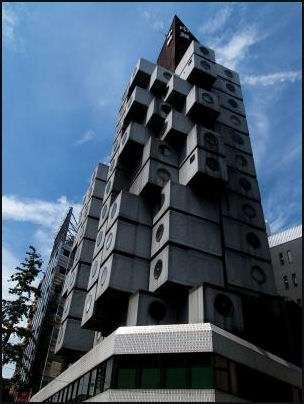
50 Human Geography of Japan Population Patterns 99 percent of Japanese belong to the same ethnic group. Most Japanese live along the coasts or in valleys or plains. Urban populations are high, with approximately 80 percent of the population living in urban areas. Extreme urbanization affects all aspects of Japanese life, including architecture, housing, transportation, and daily activities.
51
52 Human Geography of Japan Population Patterns STOP AND JOT: 3. What percentage of Japanese people belong to the same ethnic group? 4. How has rapid urbanization affected Japanese culture?
53 Human Geography of Japan Society and Culture Today The written form of the Japanese language is partly derived from Chinese, and has also incorporated English words. Shinto, Japan s predominant religion, emphasizes reverence for nature. Though Japan enjoys the longest life expectancy in the world, it is coupled with a low birthrate, straining health and social services. Women are still expected to attend to household tasks, but more are entering the workforce.
54
55 Human Geography of Japan Society and Culture Today STOP AND JOT: 5. What is Shinto? What does it emphasize? 6. Why is Japan struggling in health and social services even though it has the longest life expectancy?
56 Human Geography of Japan Economic Activities Japan s industrial economy is based on a mixed market system. Lacking ample natural resources, Japan has focused on trade to expand its economy. Japanese companies play an important societal role, with most people expecting to remain at their company until retirement. Due to the fact that Japan restricts imports, it has a trade surplus, because the value of its exports is greater than the value of its imports.
57
58 Human Geography of Japan Economic Activities STOP AND JOT: 7. Why has Japan had to focus on trade to expand its economy? 8. What is a trade surplus?
59 People and their Environment: Japan
60 People and Their Environment: Japan Managing Resources With a limited supply of fossil fuels, Japan turned to nuclear energy, but a series of accidents has exposed people to dangerous levels of radiation. Japan is grappling with meeting the demand for energy in an affordable, safe manner. Investments in solar power, wind, biomass, hydroelectric, and geothermal projects have expanded to help address this need.
61
62 People and Their Environment: Japan Managing Resources STOP AND JOT: 1. Why has Japan had to rely on Nuclear Energy? 2. What other alternatives has Japan invested in to provide cheap renewable energy?
63 People and Their Environment: Japan Human Impact Japan s rapid industrialization also brought about severe and widespread pollution problems. In the 1970s Japan began adopting stricter rules to protect air and water quality, but acidic rain remains a problem. Its reliance on the sea for food has led to the overfishing of many species. Despite an international ban, Japan is the largest consumer of whale meat.
64
65 People and Their Environment: Japan Human Impact STOP AND JOT: 1. What did rapid industrialization cause in Japan? 2. What still remains a problem due to pollution even though Japan began environmental reform in the 1970s?
66 People and Their Environment: Japan Addressing the Issues Japan is a leader in addressing environmental issues and supporting industries that profit from sustainable growth. Through the Kyoto Protocol, Japan has been working to mitigate the effects of climate change. By encouraging aquaculture and establishing quotas for fishing, Japan is attempting to offset declining fish stocks and promote the growth of fish populations.
67 People and Their Environment: Japan Addressing the Issues STOP AND JOT: 1. What is Japan doing to prevent overfishing? 2. What is Japan doing to address Environmental issues?
68 North and South Korea
69 Physical Geography of North and South Korea
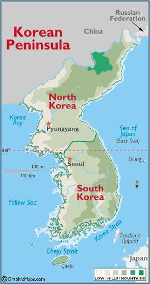
70 Physical Geography of North Korea and South Korea Landforms The mountainous Korean Peninsula lies between China and Japan. In 1945 the peninsula was split into the Democratic People s Republic of Korea, or North Korea, and the Republic of Korea, or South Korea. North Korea is the more rugged of the two. Many waterways in the region trace their source to the T aebaek Mountains. Most people live along the lowlands and the coastline in both countries.
71
72 Physical Geography of North Korea and South Korea Landforms STOP AND JOT: 1. In what year did North and South Korea split? 2. Where do most people live on the Korean Peninsula?
73 Physical Geography of North Korea and South Korea Water Systems South Korea is home to the Han River, which flows through its capital Seoul, along with the Kŭm and the Naktong Rivers. North Korea s longest river is the Yalu, which forms the border between North Korea and China. Large river valleys are important to farming and settlement in both countries. Water levels in the rivers vary throughout the year.

74
75 Physical Geography of North Korea and South Korea Water Systems STOP AND JOT: 3. What landform is important to farming in both countries? 4. What river flows through Seoul, South Korea?
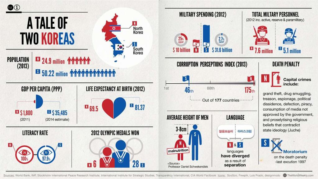
76 Physical Geography of North Korea and South Korea Climates, Biomes, and Resources The Korean Peninsula has a continental climate of cold winters and hot summers. Monsoons bring heavy rains to the peninsula in the summer. Due to deforestation, large predators like tigers and bears are nearly gone from the peninsula. Neither country has much farmland because of the rugged terrain. Rice is the peninsula s most important crop, and both countries rely heavily on fish and seafood.
77
78 Physical Geography of North Korea and South Korea Climates, Biomes, and Resources STOP AND JOT: 5. How has deforestation impacted both regions wildlife? 6. What is the peninsula s most important crop? What else do they rely on?
79 Human Geography of North and South Korea
80 Human Geography of North Korea and South Korea History and Government Greatly influenced by China, Korea adopted the principles of Confucianism, which provided the basis for a complex bureaucracy. Korea became a hermit kingdom, until Japan forced Korea to open its ports in Japan annexed Korea in 1910, creating anti- Japanese sentiment. After World War II, the Soviets set up a government in what became North Korea. Today, North Korea remains isolated, while South Korea is an open, democratic society.
81
82 Human Geography of North Korea and South Korea History and Government STOP AND JOT: 1. Who set up a communist government in North Korea? 2. How has Confucianism impacted Korean government?
83 Human Geography of North Korea and South Korea Population Patterns The peninsula is one of the most ethnically homogenous regions in the world, with nearly all inhabitants originating from China and central Asia. North Korea s population is about half of South Korea s. Food shortages and political persecution plague life in North Korea. South Korea s population is mostly urban, and population density is high.
84
85 Human Geography of North Korea and South Korea Population Patterns STOP AND JOT: 3. What issues do Koreans face? 4. Where do most people in South Korea live?
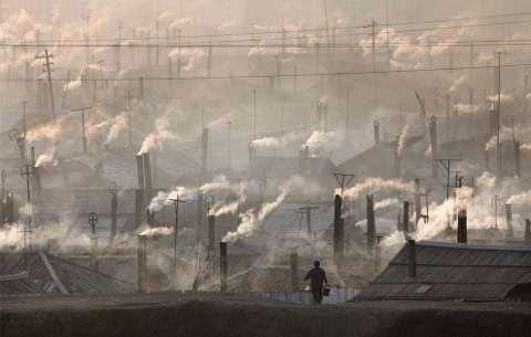
86 Human Geography of North Korea and South Korea Society and Culture Today Both nations speak Korean. Despite their shared ethnicity, the two countries have created a cultural divergence, separations of people with regard to beliefs because of differing political systems. With little freedom in North Korea, many things are prohibited, such as religion, and artistic and personal expression. With more opportunities, women in South Korea have become increasingly active in the economy.
87
88 Human Geography of North Korea and South Korea Society and Culture Today STOP AND JOT: 5. What has led to a cultural divergence between the two countries? 6. What differences are there in the way of life between North and South Koreans?
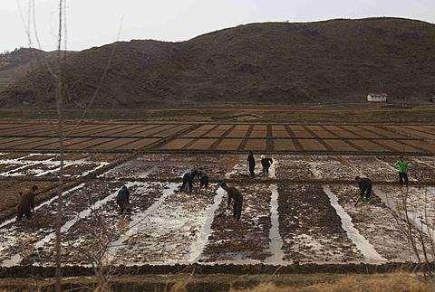
89 Human Geography of North Korea and South Korea Economic Activities North Korea has a command economy, where the state plans and controls all economic production. North Korea has a massive food problem, with many citizens facing starvation. South Korea has transformed from one of the poorest nations to a highly industrialized society. High tech manufacturing, along with the service industry, forms much of South Korea s economy. North Korea remains aloof, engaging in limited trade with its partners.
90
91 Human Geography of North Korea and South Korea Economic Activities STOP AND JOT: 7. What is a command Economy? What has this led to in North Korea? 8. What industry forms much of South Korea s economy?
92 People and their Environment: North and South Korea
93 People and Their Environment: North Korea and South Korea Managing Resources South Korea s economic transformation has created a serious air pollution problem. Sewage and sanitation have not kept up with South Korea s population growth. Untreated sewage is pumped directly into the Pacific Ocean, polluting water and affecting fish supplies. North Korea has polluted its primary river the Taedong, and the coal burned for heat causes air pollution.
94
95 People and Their Environment: North Korea and South Korea Managing Resources STOP AND JOT: 1. Why is there a serious air pollution problem in South Korea? 2. How has a lack of infrastructure harmed South Korea s water resources?
96 People and Their Environment: North Korea and South Korea Human Impact Deforestation has affected the entire Korean peninsula, reducing the habitats of many animals. The isolation and secrecy of North Korea s government makes monitoring environmental problems there difficult. Concerns have developed over drift-net fishing, the use of huge nets for fishing, because it results in the unintended deaths of many sea mammals like whales and dolphins.
97
98 People and Their Environment: North Korea and South Korea Human Impact STOP AND JOT: 3. Why is it difficult for outside governments to monitor environmental problems in North Korea? 4. What is Drift-Net Fishing? Why is it a problem?
99 People and Their Environment: North Korea and South Korea Addressing the Issues North Korea has started a reforestation program to help combat some of its environmental issues. Although the North Korean government encourages the use of fertilizer, reports indicate that it is not being fully implemented. South Korea has succeeded in restoring forests to nearly two-thirds of the country. South Korea hopes to expand its green efforts.
100
101 People and Their Environment: North Korea and South Korea Addressing the Issues STOP AND JOT: 5. How has North Korea s and South Korea s efforts in reforestation been successful? Or not successful? 6. How has North Korea attempted to fix its malnutrition problem?
Physical Geography of East Asia
 Physical Geography of East Asia Satellite View of China Landforms of China China s Geography China Miles 0 250 500 1,000 1,500 2,000 United States 3 rd largest country in the world. Comparable to the US
The Impact of Geography in South and East Asia
 The Impact of Geography in South and East Asia Gobi desert, Mongolia Essential Question: How does the geography of SE Asia impact trade and the distribution of population throughout the region? (AKS #52a)
The Impact of Geography in South and East Asia
 The Impact of Geography in South and East Asia Gobi desert, Mongolia Essential Question: How does the geography of SE Asia impact trade and the distribution of population throughout the region? (AKS #52a)
Chapter 21 Southwest Asia: Harsh & Arid Lands
 Name Hour Chapter 21 Southwest Asia: Harsh & Arid Lands Essential Question: How has the physical geography of Asia influenced the development of these regions (i.e. history, population distribution, &
South, Southeast, and East Asia. Physical Geography
 South, Southeast, and East Asia Physical Geography Mountains v Mountains are important in Asia because they influence: A. Population patterns B. Movement of people and goods C. Climate Mountains v The
East Asia. Mongolia, China, Taiwan, the Koreas, and Japan
 East Asia Mongolia, China, Taiwan, the Koreas, and Japan Major Geographic Characteristics of East Asia East Asia is the most populous region in the world China is the most populous country, and the oldest
The Impact of Geography in South and East Asia
 The Impact of Geography in South and East Asia Gobi desert, Mongolia Essential Question: How does geography impact the distribution of population throughout South and East Asia? I CAN Explain how geography
Chapter 32. Australia & New Zealand
 Chapter 32 Australia & New Zealand Lesson 1: Physical Geography of Australia & New Zealand Landforms Australia lies between the Pacific and Indian Oceans in the Southern Hemisphere. Although an island,
Chapter 32. Australia & New Zealand
 Chapter 32 Australia & New Zealand Lesson 1: Physical Geography of Australia & New Zealand Landforms Australia lies between the Pacific and Indian Oceans in the Southern Hemisphere. Although an island,
The study of Geography and the use of geographic tools help us view the world in new ways.
 S How does Geography help us understand our world? What factors shape the Earth s different environments? 7.1.9 7.2.9 BIG IDEAS COMPETENCIES Text pages or The study of Geography and the use of geographic
Chapter 27. Bhutan, Maldives, Nepal, & Sri Lanka
 Chapter 27 Bhutan, Maldives, Nepal, & Sri Lanka Physical Geography of Bhutan, Maldives, Nepal & Sri Lanka Landforms Their locations on the fringe of South Asia means their physical and human geography
Chapter 23. Equatorial Africa
 Chapter 23 Equatorial Africa Section 1 - Physical Geography of Equatorial Africa Landforms Equatorial Africa, or the Heart of Africa, is a tropical subregion located on and near the Equator in Central
Landforms. Lesson 1: Physical Geography of Canada Mexico. Canada s mountainous eastern and western edges create a central region of fertile plains.
 Lesson 1: Physical Geography of Canada Mexico Landforms Canada s mountainous eastern and western edges create a central region of fertile plains. Collisions of tectonic plates thrust up a series of sharp-peaked
Chapter 27. Bhutan, Maldives, Nepal, & Sri Lanka
 Chapter 27 Bhutan, Maldives, Nepal, & Sri Lanka Physical Geography of Bhutan, Maldives, Nepal & Sri Lanka Landforms Their locations on the fringe of South Asia means their physical and human geography
MARS AREA SCHOOL DISTRICT CURRICULUM GRADE: Grade 4
 MARS AREA SCHOOL DISTRICT CURRICULUM GRADE: Grade 4 Course Title: Social Studies Brief Description Overview: Students will explore the history, geography, government, and economy of the United States with
Sec$on 1: Geography and Early China. How does China s geography affect the culture?
 Sec$on 1: Geography and Early China How does China s geography affect the culture? Con$nents of the World Label the continents. Where is China located? Where is China located? In your groups, begin filling
Wednesday, May 23, 2018
 Wednesday, May 23, 2018 Physical Geography of West Africa Objective: Summarize the main geographic aspects of each country in West Africa. Understand each country s development pattern and their current
9/20/2015. Ancient China. Outcome: Geography & Culture
 Ancient China Outcome: Geography & Culture 1 Constructive Response Question 1. Describe China s geography and give examples as to how the Chinese adapted to it? 2 What will we learn? 1. Geography of China
Chapter 24 Southern Africa
 Chapter 24 Southern Africa Section 1 - Physical Geography of Southern Africa Landforms Southern Africa consists of ten mainland countries and four island countries. Most of Southern Africa sits at a high
Explain the impact of location, climate, natural resources, and population distribution on Europe. a. Compare how the location, climate, and natural
 SS6G10 Explain the impact of location, climate, natural resources, and population distribution on Europe. a. Compare how the location, climate, and natural resources of Germany, the United Kingdom and
Peoples, Places and Cultures in Africa, Asia and the Southwest Pacific
 GRADE 7 Peoples, Places and Cultures in Africa, Asia and the Southwest Pacific Course 0470-07 Students in seventh grade explore the history, geography, government, economic systems, current issues, and
Introduction to Japan
 Introduction to Japan Unit 5 Table of Contents Japan 1. On INB 80 create a NEW table of Contents titled Unit 5 Medieval Japan A.D. 300 1300) and number that page 81 91 2. Number your next INB pages through
World Geography Fall 2013 Semester Review Project
 Reporting Category RC 1: History, Government and Citizenship Standard WG.1 History. The student understands how geography and processes of spatial exchange (diffusion) influenced events in the past and
By Geri Flanary To accompany AP Human Geography: A Study Guide 3 rd edition By Ethel Wood
 Session 1 By Geri Flanary To accompany AP Human Geography: A Study Guide 3 rd edition By Ethel Wood WHAT IS DEMOGRAPHY? It is the scientific or statistical study of population. It comes from the Greek
Central Valley School District Social Studies Curriculum Map Grade 7. August - September
 August - September Geographical/Historical Skills Identify and analyze timelines. Construct and use cause and effect charts. Differentiate between fact and opinion. Use of word webs, flip charts, outlines
WORLD GEOGRAPHY INSTRUCTIONAL PACING GUIDE
 FIRST NINE WEEKS Standard USHC-1 Standard WG-1: The student will demonstrate an understanding of the physical and human characteristics of places, including the creation of regions and the ways that culture
September 14, 2013 Objective: How does geography impact history? What important features exist that have shaped societies?
 Lowenhaupt 1 September 14, 2013 Objective: How does geography impact history? What important features exist that have shaped societies? Warm-Up: In your binder, answer the following question: Imagine you
Lesson- 6 WEATHER AND CLIMATE
 Lesson- 6 WEATHER AND CLIMATE New Words 1. Heat Zones:- the division of the earth according to the climate. 2. Frigid:- the zone that is the coldest 3. Temperate:- the zone that is neither too hot nor
Presentation Plus! Glencoe World Geography Copyright by The McGraw-Hill Companies, Inc. Developed by FSCreations, Inc., Cincinnati, Ohio 45202
 Presentation Plus! Glencoe World Geography Copyright by The McGraw-Hill Companies, Inc. Developed by FSCreations, Inc., Cincinnati, Ohio 45202 Send all inquiries to: GLENCOE DIVISION Glencoe/McGraw-Hill
Post Test Trimester 1 US & Canada 6th Grade-Study Guide
 Post Test Trimester 1 US & Canada 6th Grade-Study Guide Matching Fill in the blank by writing the letter of the correct term below. a. dominion f. indigenous b. Industrial Revolution g. interdependent
STAAR Vocabulary Words extracted directly from the standard and/or associated with the instruction of the content within the standard.
 STAAR Vocabulary Words extracted directly from the standard and/or associated with the instruction of the content within the standard. READINESS STANDARDS - World Geography (WG.1) History. The student
Grade Five Social Studies Assessment Regions/Native Americans
 Name Grade Five Social Studies Assessment Regions/Native Americans Use the map below to answer questions 1 and 2 1. (Geo 1) For this location give the name of the city found there. 38 N, 100 W a. Scottsbluff
EQ: Discuss main geographic landforms of the U.S. & Canada and examine varied landforms in relation to their lifestyles.
 EQ: Discuss main geographic landforms of the U.S. & Canada and examine varied landforms in relation to their lifestyles. Places & Terms for Discussion Appalachian Mountains Great Plains Canadian Shield
World Geography Review Syllabus
 Purpose Class: World Geography Review Syllabus This course is designed to help students review and remediate their understanding major themes, concepts, and facts connected to the study World Geography.
Physical Geography of the United States and Canada Chapter 5 A Land of Contrasts
 Physical Geography of the United States and Canada Chapter 5 A Land of Contrasts Land Area Together the U.S. and Canada cover more than 7 million square miles. In total area, Canada ranks 2 nd and the
Thursday, April 27, 17
 Thursday, April 27, 17 Geography of Southeast Asia Objec-ve: Understand the geographical differences between the mainland region and the insular region of Southeast Asia. Do Now: What is the capital of
Unit 1 Basic Geographical Concepts and Themes of Geography
 Unit 1 Basic Geographical Concepts and Themes of Geography Physical: Mount Everest Political: Nepalese Sherpa What is Geography? -Geography, simply put, is the study of the Earth s surface. This includes
Grade 7 Social Studies
 Standard 1: History Students will examine the major movements, events, and figures that contributed to the development of nations in modern Africa, Asia, and the Southwest Pacific from acient civilizations
Geography Policy. Introduction
 Geography Policy Introduction Geography at St. Aloysius Federation School teaches an understanding of places and environments and aims to inspire a curiosity and fascination about the world and its people.
Centerville Jr. High School Curriculum Mapping (7 th Grade Geography) (Mike Day)
 (Mike Day)") Centerville Jr. High School Curriculum Mapping (7 th Grade Geography) (Mike Day) Standard 1 History Students examine the major movements, events and figures that contributed to the development of Africa,
Centerville Jr. High School Curriculum Mapping (7 th Grade Geography) (Mike Day) Standard 1 History Students examine the major movements, events and figures that contributed to the development of Africa,
UNIT 11 SOUTH ASIA SG 1 - PHYSICAL GEOGRAPHY & THE ENVIRONMENT
 UNIT 11 SOUTH ASIA SG 1 - PHYSICAL GEOGRAPHY & THE ENVIRONMENT I. PHYSICAL GEOGRAPHY TAKE OUT YOUR PHYSICAL MAP OF SOUTH ASIA A. The Himalayan Mountains form the northern boundary of the region (color
Ancient China UNIT 4 GEOGRAPHY CHALLENGE. 1 Unit 4 Geography Challenge. Teachers Curriculum Institute
 UNIT 4 GEOGRAPHY CHALLENGE Ancient China N W E S 0 250 500 miles 0 250 500 kilometers Albers Conic Equal-Area Projection AW_ISN_U04_01 Ancient China Second Proof TCI18 108 1 Unit 4 Geography Challenge
Social Studies Final Exam Review Packet Exam Date: a. movement b. human-environment interaction c. region d. location e. place
 Name Date Per Social Studies Final Exam Review Packet Exam Date: Part 1: Five Themes of Geography Fill in the correct letter for each theme. a. movement b. human-environment interaction c. region d. location
Australia and New Zealand: Powerpoint
 Australia and New Zealand: Powerpoint Physical Geography Australia and New Zealand are between the Indian and Pacific Oceans. Australia s seasons are opposite of the United States due to their location.
Eastern Hemisphere Geography 7th Grade *Chapters 1-10 covered in 6 th Grade
 Quarter 1 Geography Tools and Concepts Chapters 1-5 Intro to Geography = 2 day review Goal Objective Task Analysis Vocabulary Text Location Goal 2.1: Analyze the 6-9.GEH.2.1.1 Explain and use the Identify
STAAR Science Tutorial 48 TEK 8.11C: Effects of Environmental Change
 Name: Teacher: Pd. Date: STAAR Science Tutorial 48 TEK 8.11C: Effects of Environmental Change TEK 8.11C: Explore how short- and long-term environmental changes affect organisms and traits in subsequent
California: Land and People Lesson 1: Locating California
 California: Land and People Lesson 1: Locating California Hemisphere One half of the earth or another sphere Video on Hemispheres click here Relative location Where a place is compared to one or more other
World Geography Mid Term Review 2016
 World Geography Mid Term Review 2016 1.Latitude and Longitude Lines of latitude run and. The zero-degree line is the. Line of longitude run and. The zero degree line is called the. 2. Map Projections What
Ancient China. Teachers Curriculum Institute Geography and the Early Settlement of China 1. AW_ISN_U04_01 Ancient China Second Proof TCI18 108
 G e o g r a p h y C h a l l e n g e Ancient China N W E S 0 250 500 miles 0 250 500 kilometers Albers Conic Equal-Area Projection AW_ISN_U04_01 Ancient China Second Proof TCI18 108 Teachers Curriculum
TRIBUNE MODEL SCHOOL Syllabus for Session Subject: Social Science CLASS IV
 TRIBUNE MODEL SCHOOL Syllabus for Session 2017-18 Subject: Social Science CLASS IV Text Books 1. Candid New Trends in Social Science 4 2. Candid New Trends in Social Science (Worksheets) 4 Term I (Chapters
GEOGRAPHY POLICY STATEMENT. The study of geography helps our pupils to make sense of the world around them.
 GEOGRAPHY POLICY STATEMENT We believe that the study of geography is concerned with people, place, space and the environment and explores the relationships between the earth and its peoples. The study
Chapter 1. Social Studies History and Geography
 Chapter 1 Social Studies History and Geography Unit 01 Geography Skills 1 Reading Maps Key Words border landform rely on display focus on route locater 1 There are many different kinds of maps. A political
Reading for Information Grade 2 Correlations to Idaho Content Standards
 Science Life Science Physical Science Grade 2 Leveled Plants Live and Grow Plants: Alive and Growing Plants: Living and Growing It Takes Force Making Things Move Facts about Force Grade 2 Correlations
(version 3) I. HumAN -Environment Interaction
 I. HumAN -Environment Interaction") (version 3) I. HumAN -Environment Interaction A. Landforms 1. Earth s topography is made up of many different types of landforms. 2. While the planet is covered primarily with water, the four major types
(version 3) I. HumAN -Environment Interaction A. Landforms 1. Earth s topography is made up of many different types of landforms. 2. While the planet is covered primarily with water, the four major types
HOW GEOGRAPHY AND GEOLOGY AFFECT BIOLOGICAL DIVERSITY
 HOW GEOGRAPHY AND GEOLOGY AFFECT BIOLOGICAL DIVERSITY Factors Affecting Extinction Rates Natural Factors Climate change Cataclysmic event (volcano, earthquake) Human Activities Habitat Loss/Fragmentation
Chapter 26-28: East Asia
 Chapter 26-28: East Asia Growing competition JAKOTA TRIANGLE JApan south KOrea & TAiwan 2 Introduction East Asia is the most populous region in the world 1.3 BILLION people China is the most populous country,
World Geography Chapter 3
 World Geography Chapter 3 Section 1 A. Introduction a. Weather b. Climate c. Both weather and climate are influenced by i. direct sunlight. ii. iii. iv. the features of the earth s surface. B. The Greenhouse
Pikes Lane Primary School. Geography Statement of Practice
 Pikes Lane Primary School Geography Statement of Practice Subject Leader: Mrs Cawley Subject Link Governor: Mr Scholar & Mrs Azad Last Updated: September 2016 Review Date: September 2017 Aims and objectives
Term Knowledge Using and applying Grade Criteria Autumn 1 Assessment window October Natural hazards pose major risks to people and property.
 Assessment Schedule Year 9 2015/6 Term Knowledge Using and applying Grade Criteria Autumn 1 Assessment window October 2015 3.1.1.2 Tectonic Natural hazards pose major risks to people and property. Definition
Prentice Hall. World Explorer: People, Places, Cultures Grade 7. Oklahoma Priority Academic Student Skills (PASS) for Grade 7 World Geography
 for Grade 7 World Geography") Prentice Hall World Explorer: People, Places, Cultures 2007 Grade 7 C O R R E L A T E D T O for Grade 7 1. Locate, gather, analyze, and apply information from primary and secondary sources. WORLD GEOGRAPHY
Prentice Hall World Explorer: People, Places, Cultures 2007 Grade 7 C O R R E L A T E D T O for Grade 7 1. Locate, gather, analyze, and apply information from primary and secondary sources. WORLD GEOGRAPHY
The United States & Canada. A Regional Study of Anglo America
 A Regional Study of Anglo America Landform Regions of the United States & Canada world leaders in agricultural and industrial production because of... VAST LANDS stretch from the Atlantic Ocean on the
MASSACHUSETTS HISTORY & SOCIAL SCIENCE LEARNING STANDARDS Grade 6 HISTORY AND GEOGRAPHY
 Massachusetts History and Social Science Curriculum Framework Learning Standards, World Geography (Grade 6) Grade 6 HISTORY AND GEOGRAPHY 1. Use map and globe skills learned in prekindergarten to grade
MEADOWS PRIMARY SCHOOL and NURSERY GEOGRAPHY POLICY
 MEADOWS PRIMARY SCHOOL and NURSERY GEOGRAPHY POLICY Purpose of study The teaching of Geography at Meadows is done by following the 2014 National Curriculum. The planning and teaching of the subject aims
Quarterly Pacing Guide 6th grade Social Studies Content Expectations
 6.G1 The World in Spacial Term Terms: Geographical Habits of Mind 6.G1.1 Spacial Thinking 6 - G1.1.1 Use maps, globes, and web based geography technology to investigate the world at global, interregional,
INDIANA ACADEMIC STANDARDS FOR SOCIAL STUDIES, WORLD GEOGRAPHY. PAGE(S) WHERE TAUGHT (If submission is not a book, cite appropriate location(s))
 WHERE TAUGHT (If submission is not a book, cite appropriate location(s))") Prentice Hall: The Cultural Landscape, An Introduction to Human Geography 2002 Indiana Academic Standards for Social Studies, World Geography (Grades 9-12) STANDARD 1: THE WORLD IN SPATIAL TERMS Students
Prentice Hall: The Cultural Landscape, An Introduction to Human Geography 2002 Indiana Academic Standards for Social Studies, World Geography (Grades 9-12) STANDARD 1: THE WORLD IN SPATIAL TERMS Students
GRADE LEVEL: SIXTH SUBJECT: SOCIAL STUDIES DATE: CONTENT STANDARD INDICATORS SKILLS ASSESSMENT VOCABULARY ISTEP
 CRAWFORDSVILLE COMMUNITY SCHOOL CORPORATION GRADE LEVEL: SIXTH SUBJECT: SOCIAL STUDIES DATE: 2016 2017 GRADING PERIOD: QUARTER 3 MASTER COPY 11 28 16 CONTENT STANDARD INDICATORS SKILLS ASSESSMENT VOCABULARY
Groveport Madison Local School District Sixth Grade Social Studies Content Standards Planning Sheets
 Standard: Citizenship Rights and Responsibilities A. Show the relationship between civic participation and attainment of civic and public goals. 1. Explain how opportunities for citizens to participate
SOCIAL STUDIES Grade 6 Standard: History
 Standard: History Chronology A. Interpret relationships between events shown on multipletier 1. Construct a multiple-tier time line from a list of events time lines. and interpret the relationships between
UNIT4. Ancient China. Geography and the Early Settlement of China. Three Chinese Philosophies The First Emperor of China
 UNIT4 Ancient China Lesson 19 Lesson 20 Lesson 21 Lesson 22 Lesson 23 Lesson 24 Geography and the Early Settlement of China The Shang Dynasty Three Chinese Philosophies The First Emperor of China The Han
Pacemaker World Geography and Cultures. correlated to. Louisiana Social Studies Grade Level Expectations: World Geography Geography Grades 9-12
 Pacemaker World and Cultures correlated to Louisiana Social Studies Grade Level Expectations: World Grades 9-12 Pacemaker World and Cultures Pearson Learning Group correlated to Louisiana Social Studies
Arizona Educator Proficiency Assessments (AEPA ) FIELD 04: GEOGRAPHY TEST OBJECTIVES
 FIELD 04: GEOGRAPHY TEST OBJECTIVES") Arizona Educator Proficiency Assessments (AEPA ) TEST OBJECTIVES Subarea Range of Objectives Approximate Test Proportions I. Geographic Concepts and Skills 1 6 25% II. World Geography 7 14 34% III. United
Arizona Educator Proficiency Assessments (AEPA ) TEST OBJECTIVES Subarea Range of Objectives Approximate Test Proportions I. Geographic Concepts and Skills 1 6 25% II. World Geography 7 14 34% III. United
New GCSE Geography AQA
 Learning Checklist Half Term 1 26 th September 3 rd October 10 th October 17 th October 1.1.1 Tectonic Hazards Plate tectonics theory. Global distribution of earthquakes and volcanic eruptions and their
KNES Geography Course Outline. Year 8
 KNES Geography Course Outline Year 8 Geography is the study of Earth s landscapes, peoples, places and environments. It is, quite simply, about the world in which we live. Geography is unique in bridging
a. Hunting and gathering SE/TE: 17, 19, 21, 22, 23, 25, 30 b. Tool making SE/TE: 17, 18, 19, 22, 23 c. Use of fire SE/TE: 17, 23, 30
 Ohio Academic Content Standards, Social Studies, Benchmarks and Indicators (Grade 6) Grade Six History Students use materials drawn from the diversity of human experience to analyze and interpret significant
Chapter 2 - Lessons 1 & 2 Studying Geography, Economics
 Chapter 2 - Lessons 1 & 2 Studying Geography, Economics How does geography influence the way people live? Why do people trade? Why do people form governments? Lesson 1 - How Does Geography Influence the
LEARNING OUTCOMES SST (G1-G12)
") LEARNING OUTCOMES SST (G1-G12) Grade 1 Learning Outcomes Students will be expected to: - demonstrate an understanding of the importance of interactions between people - demonstrate an understanding of
LEARNING OUTCOMES SST (G1-G12) Grade 1 Learning Outcomes Students will be expected to: - demonstrate an understanding of the importance of interactions between people - demonstrate an understanding of
Greenland: Balancing the need for development and environmental protection. Arctic Frontiers 2016 Industry and Environment
 Greenland: Balancing the need for development and environmental protection Arctic Frontiers 2016 Industry and Environment Speech by Minister for Finance, Mineral Resources and Foreign Affairs Mr. Vittus
Geography 7 Final Exam Review Guide (Eppler)- 2014
- 2014") Geography 7 Final Exam Review Guide (Eppler)- 2014 Name Hour EXAM SPECIFICS There are five types of questions on this exam 1. Multiple choice (41) 2. Maps (5) 3. Short reading passages (5) 4. Tables /
Geography 7 Final Exam Review Guide (Eppler)- 2014 Name Hour EXAM SPECIFICS There are five types of questions on this exam 1. Multiple choice (41) 2. Maps (5) 3. Short reading passages (5) 4. Tables /
Geographic Terms and Concepts
 Geographic Terms and Concepts When studying the discipline of geography and considering the various terms and concepts that geographers utilize, it might be helpful to contemplate the following points.
Amarillo ISD Social Studies Curriculum
 Amarillo Independent School District follows the Texas Essential Knowledge and Skills (TEKS). All of AISD curriculum and documents and resources are aligned to the TEKS. The State of Texas State Board
Physical Geography: Patterns, Processes, and Interactions, Grade 11, University/College Expectations
 Geographic Foundations: Space and Systems SSV.01 explain major theories of the origin and internal structure of the earth; Page 1 SSV.02 demonstrate an understanding of the principal features of the earth
World Geography. WG.1.1 Explain Earth s grid system and be able to locate places using degrees of latitude and longitude.
 Standard 1: The World in Spatial Terms Students will use maps, globes, atlases, and grid-referenced technologies, such as remote sensing, Geographic Information Systems (GIS), and Global Positioning Systems
Rhode Island World-Class Standards Science Grade: K - Adopted: 2006
 Main Criteria: Rhode Island World-Class Standards Secondary Criteria: Subjects: Science, Social Studies Grade: K Correlation Options: Show Correlated Rhode Island World-Class Standards Science Grade: K
LOUISIANA STUDENT STANDARDS FOR SOCIAL STUDIES THAT CORRELATE WITH A FIELD TRIP TO DESTREHAN PLANTATION KINDERGARTEN
 LOUISIANA STUDENT STANDARDS FOR SOCIAL STUDIES THAT CORRELATE WITH A FIELD TRIP TO DESTREHAN PLANTATION KINDERGARTEN Standard 2 Historical Thinking Skills Students distinguish between events, people, and
Tropical Moist Rainforest
 Tropical or Lowlatitude Climates: Controlled by equatorial tropical air masses Tropical Moist Rainforest Rainfall is heavy in all months - more than 250 cm. (100 in.). Common temperatures of 27 C (80 F)
Norwich City Schools Social Studies 6
 Social Studies 6 Topic: Maps and Globes and Graphs and Time Transferable Concepts: change 3: Geography Geography Geographers use maps, globes, and graphs to study the Earth and everything on it. Types
Subject Area: Geography
 Long Term Planning Overview Key Stage 3 Subject Area: Geography Academic : 08-9 7 Assessment Your Island Home the physical and human geography of the UK and will investigate weather patterns, population
Introduction to Development. Indicators and Models
 Introduction to Development Indicators and Models First World vs. Third World Refers to economic development Diversity and complexity of economy High per capita income Developed during the Cold War First
2018 Geography Mock Examination
 2018 Geography Mock Examination Your Geography mock examination will test your understanding of Paper 1 (Living with the physical environment) and Section B (Fieldwork) from Paper 2. Attached are the necessary
SPLIT UP OF SYLLABUS ( )
") April M Unit/Chapter 1.India - our country. 2. The Northern Mountains. Concepts/Sub topic *Neighboring countries and States of India. *Physical divisions of India. Learning Outcomes Mapping Skill: Identify
April M Unit/Chapter 1.India - our country. 2. The Northern Mountains. Concepts/Sub topic *Neighboring countries and States of India. *Physical divisions of India. Learning Outcomes Mapping Skill: Identify
Complete Geography Overview: Year 1 to Year 6
 Option 1 Complete Geography Overview: Year 1 to Year 6 Autumn Term Spring Term Summer Term Year 1 Where do I live? Around the World The Four Seasons Year 2 At the Farm Let s go on Safari My World and Me
HOLY CROSS CATHOLIC PRIMARY SCHOOL
 HOLY CROSS CATHOLIC PRIMARY SCHOOL Geography Policy Date Implemented Jan 17 Review Date Jan 22 Mission Statement Holy Cross Primary School is a Catholic School. We seek to provide a broad, balanced Christian
Exemplar for Internal Assessment Resource Geography Level 3. Resource title: Water, water, everywhere?
 Exemplar for internal assessment resource Geography 3.7A for Achievement Standard 91432 Exemplar for Internal Assessment Resource Geography Level 3 Resource title: Water, water, everywhere? This exemplar
Social Studies World Geography Unit 01: Physical Geography
 Social Studies World Geography Unit 01: Physical 012 2013 1 Tectonic plate movement may be caused by all of the following EXCEPT A slab pull B ridge push C convection D magnetism 2 An earthquake is part
Ganbat.B, Agro meteorology Section
 NATIONAL AGENCY FOR METEOROLOGY, HYDROLOGY AND ENVIRONMENT MONITORING OF MONGOLIA Ganbat.B, Agro meteorology Section OF INSTITUTE OF METEOROLOGY AND HYDROLOGY 2009 YEAR Location Climate Northern Asia,
Wednesday, November 15, 2017
 Wednesday, November 15, 2017 Northern Europe: Physical Geography Objective: Locate and describe the various traditional regions of Western Europe. Outline how the physical geography varies from region
The Geography Curriculum at Coston Primary
 The Geography Curriculum at Coston Primary Years Year 1 Year 2 Summer We are learning about where food is farmed and in The physical features of farms. The human features of farms. The characteristics
Minnesota K-12 Academic Standards in Social Studies. Grade 4: Geography of North America
 Minnesota K-12 Academic s in Social Studies Grade 4: Geography of North America 4 Describe how people take 1. Democratic government action to influence a depends on informed and decision on a specific
Geography Long Term Plan 2018
 Geography Long Term Plan 2018 Geography Co-ordinator: Megan Frost A high-quality geography education should inspire in pupils a curiosity and fascination about the world and its people that will remain
Why Geography Matters
 Why Geography Matters Vocabulary words geography relative location absolute location physical feature human feature region modify adapt cause effect geography: The study of the Earth s physical and human