9/20/2015. Ancient China. Outcome: Geography & Culture
|
|
|
- Ashlie Wright
- 6 years ago
- Views:
Transcription

1 Ancient China Outcome: Geography & Culture 1

2 Constructive Response Question 1. Describe China s geography and give examples as to how the Chinese adapted to it? 2
3 What will we learn? 1. Geography of China 2. The earliest dynasties (Xia, Zhou, Shang) 3. Development of Chinese culture 3

4 Satellite Image 4

5 Geography & Culture 1. Setting the Stage: a. China s first city walls were built 1000 years after the walls of Ur, the great pyramids, and the planned cities on the Indus River. b. Unlike most cultures on earth, the civilization that began in China 4000 years ago still thrives there today. 5
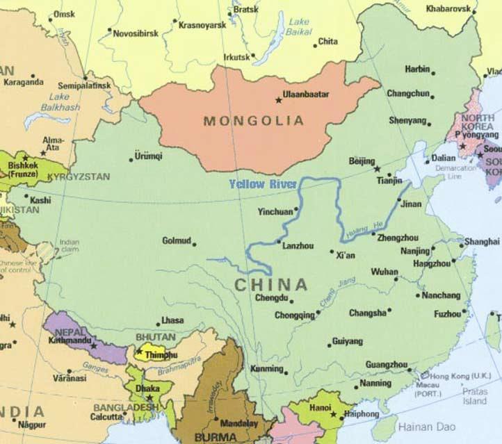
6 Geography & Culture 2. The Geography of China a. Natural barriers isolated ancient China b. East: The Yellow Sea, East China Sea, and Pacific Ocean c. West: Taklimakan Desert and 15,000 ft Plateau of Tibet d. Southwest: Himalayas e. North: Gobi Desert and Mongolian Plateau f. Mountain ranges and desert dominate 2/3 of China s landmass 6

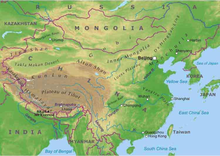
7 7
 in the north 1.")

8 Geography & Culture g. River Systems i. Huang He (Yellow River) in the north 1. Deposits large amounts of yellowish silt called loess. 2. Loess is blown by winds from deserts into the river 8

9 Huang He (Yellow River) 9

10 Geography & Culture i. Chang Jiang (Yangtze) in central China 1. Flows east from the Yellow Sea 2. At 3,988 miles long, it is the longest river in Asia 10

11 Geography & Culture h. Environmental Challenges i. Disastrous floods from the Huang He ii. Trade was difficult so settlers became selfdependent iii. Geography did not make invasion impossible 11

12 Geography & Culture i. Only 10% of China s land is suitable for farming j. Most of farmable land is on North China Plain between Yellow River and Yangtze 12

13 Earliest Dynasties 13

14 Zhou & Shang Culture 14

15 Geography & Culture 3. The Development of Chinese Culture a. Fossils show that modern humans lived in SW China 1.7 million years ago b. According to legend, the first Chinese dynasty, The Xia Dynasty, started about 2000 B.C. c. Chinese viewed everyone outside of their culture as barbarians d. Viewed themselves as center of civilized world e. Chinese name for China was Middle Kingdom f. Family is central to Chinese society; respect for one s parents g. Women treated as inferiors h. Girls were arranged to be married between 13 and 16 15

16 Geography & Culture i. Religion: Spirits of ancestors had power to bring good fortune; not seen as gods j. Use of Oracle Bones- priests scratch question on bones, apply hot poker, bone would split, interpret the cracks 16

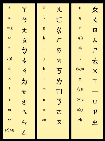
17 Geography & Culture k. No links between spoken and written language l. One could read Chinese without being able to speak the language m. All parts of China learned the same system of writing even if spoke different language thus unifying parts of China n. Needed to know 1500 characters just to be considered literate; scholars knew 10,000 characters 17

18 Chinese alphabet 18

19 Zhou dynasty contributions 19
20 Geography & Culture 4. Zhou and the Dynastic Cycle a B.C. a people called the Zhou overthrew the Shang, culturally similar b. Zhou believed in Mandate of Heaven or divine approval to rule c. Mandate of Heaven became central to Chinese view of government d. This helped explain the dynastic cycle: a pattern of rise, decline, and replacement of dynasties if the spirits did not approve of one king s rule 20

21 Mandate of Heaven 21

22 Dynastic Cycle 22


23 Geography & Culture 4. Zhou and the Dynastic Cycle e. The use of royal families controlling different regions was known as feudalism f. Zhou Dynasty innovated roads/canals, coined money, blast furnaces g. The Zhou were generally peaceful h. Later years of Zhou Dynasty known as warring states period due to weakened power of Zhou kings, attacking nomads and greedy lords 23

24 Warring States period 24

25 Geography & Culture Result: China s culture has been shaped by the geography surrounding it s people. A highly evolved culture that began with the Xia, Shang, and Zhou Dynasties will become one of the world s oldest. This unique people will be regularly disrupted by rise and fall of governments, that will later be known as the dynastic cycle. Our studies in this unit will focus on 5 of those dynasties: The Qin, The Han, The Tang, The Song, and the Yuan. 25
26 Constructive Response Question 1. Describe China s geography and give examples as to how the Chinese adapted to it? 26
Sec$on 1: Geography and Early China. How does China s geography affect the culture?
 Sec$on 1: Geography and Early China How does China s geography affect the culture? Con$nents of the World Label the continents. Where is China located? Where is China located? In your groups, begin filling
Ancient China UNIT 4 GEOGRAPHY CHALLENGE. 1 Unit 4 Geography Challenge. Teachers Curriculum Institute
 UNIT 4 GEOGRAPHY CHALLENGE Ancient China N W E S 0 250 500 miles 0 250 500 kilometers Albers Conic Equal-Area Projection AW_ISN_U04_01 Ancient China Second Proof TCI18 108 1 Unit 4 Geography Challenge
Ancient China. Teachers Curriculum Institute Geography and the Early Settlement of China 1. AW_ISN_U04_01 Ancient China Second Proof TCI18 108
 G e o g r a p h y C h a l l e n g e Ancient China N W E S 0 250 500 miles 0 250 500 kilometers Albers Conic Equal-Area Projection AW_ISN_U04_01 Ancient China Second Proof TCI18 108 Teachers Curriculum
The Impact of Geography in South and East Asia
 The Impact of Geography in South and East Asia Gobi desert, Mongolia Essential Question: How does geography impact the distribution of population throughout South and East Asia? I CAN Explain how geography
The Impact of Geography in South and East Asia
 The Impact of Geography in South and East Asia Gobi desert, Mongolia Essential Question: How does the geography of SE Asia impact trade and the distribution of population throughout the region? (AKS #52a)
UNIT4. Ancient China. Geography and the Early Settlement of China. Three Chinese Philosophies The First Emperor of China
 UNIT4 Ancient China Lesson 19 Lesson 20 Lesson 21 Lesson 22 Lesson 23 Lesson 24 Geography and the Early Settlement of China The Shang Dynasty Three Chinese Philosophies The First Emperor of China The Han
The Impact of Geography in South and East Asia
 The Impact of Geography in South and East Asia Gobi desert, Mongolia Essential Question: How does the geography of SE Asia impact trade and the distribution of population throughout the region? (AKS #52a)
Chapter 21 Southwest Asia: Harsh & Arid Lands
 Name Hour Chapter 21 Southwest Asia: Harsh & Arid Lands Essential Question: How has the physical geography of Asia influenced the development of these regions (i.e. history, population distribution, &
Social Studies Final Exam Review Packet Exam Date: a. movement b. human-environment interaction c. region d. location e. place
 Name Date Per Social Studies Final Exam Review Packet Exam Date: Part 1: Five Themes of Geography Fill in the correct letter for each theme. a. movement b. human-environment interaction c. region d. location
Social Studies: The World Post Test Study Guide
 Name: Period: Social Studies: The World Post Test Study Guide Map and Globe Skills: Label the continents and oceans on the lines below the map. 1 11 3 4 5 8 2 9 10 8 6 7 1. 8. 2. 9. 3. 10. 4. 11. 5. 6.
South, Southeast, and East Asia. Physical Geography
 South, Southeast, and East Asia Physical Geography Mountains v Mountains are important in Asia because they influence: A. Population patterns B. Movement of people and goods C. Climate Mountains v The
East Asia. Mongolia, China, Taiwan, the Koreas, and Japan
 East Asia Mongolia, China, Taiwan, the Koreas, and Japan Major Geographic Characteristics of East Asia East Asia is the most populous region in the world China is the most populous country, and the oldest
Peoples, Places and Cultures in Africa, Asia and the Southwest Pacific
 GRADE 7 Peoples, Places and Cultures in Africa, Asia and the Southwest Pacific Course 0470-07 Students in seventh grade explore the history, geography, government, economic systems, current issues, and
Physical Geography of East Asia
 Physical Geography of East Asia Satellite View of China Landforms of China China s Geography China Miles 0 250 500 1,000 1,500 2,000 United States 3 rd largest country in the world. Comparable to the US
Grade 7 Social Studies
 Standard 1: History Students will examine the major movements, events, and figures that contributed to the development of nations in modern Africa, Asia, and the Southwest Pacific from acient civilizations
China Day 5 The Shang Dynasty
 China Day 5 The Shang Dynasty AIMS: SWBAT describe the Chinese practice of ancestor worship. SWBAT explain the concept of oracle bones and how they connected writing and religion. Do Now a home shrine
The Zhuan Xu People were the Founders of Sanxingdui Culture and Earliest Inhabitants of South Asia
 The Zhuan Xu People were the Founders of Sanxingdui Culture and Earliest Inhabitants of South Asia Soleilmavis Liu E-Leader Conference held by CASA (Chinese American Scholars Association) and Stamford
Unit 1: Basics of Geography Test Review
 Name Date Period Unit 1: Basics of Geography Test Review Directions: Reading the following sections and complete the questions, charts, and diagrams. Types of Maps Maps that have a particular theme are
Social Studies: The World (End of the Year TEST)
") Name: Period: TEST A Social Studies: The World (End of the Year TEST) Map and Globe Skills: Label the continents and oceans on the lines below the map. 1 11 3 4 5 8 2 9 10 8 6 7 1. 8. 2. 9. 3. 10. 4. 11.
Name: Period: TEST A Social Studies: The World (End of the Year TEST) Map and Globe Skills: Label the continents and oceans on the lines below the map. 1 11 3 4 5 8 2 9 10 8 6 7 1. 8. 2. 9. 3. 10. 4. 11.
By Geri Flanary To accompany AP Human Geography: A Study Guide 3 rd edition By Ethel Wood
 Session 1 By Geri Flanary To accompany AP Human Geography: A Study Guide 3 rd edition By Ethel Wood WHAT IS DEMOGRAPHY? It is the scientific or statistical study of population. It comes from the Greek
September 14, 2013 Objective: How does geography impact history? What important features exist that have shaped societies?
 Lowenhaupt 1 September 14, 2013 Objective: How does geography impact history? What important features exist that have shaped societies? Warm-Up: In your binder, answer the following question: Imagine you
DIRECTIONS: Complete each of the enclosed activities and then use what you learn along with prior knowledge to fill in the outline below:
 DIRECTIONS: Complete each of the enclosed activities and then use what you learn along with prior knowledge to fill in the outline below: I. Geography of Sumer A. Located in modern-day B. Between two rivers
Test Bank Introduction to Geography People, Places & Environment 6th Edition Carl H. Dahlman, William H. Renwick
 Test Bank Introduction to Geography People, Places & Environment 6th Edition Carl H. Dahlman, William H. Renwick Instant download and all chapters TESK BANK Introduction to Geography People, Places & Environment
Grade 4. Social Studies
 Grade 4 Social Studies Regions of the United States Canada Mexico Ancient China Regions of the United States Use map and globe skills to determine absolute locations (latitude and longitude) of places
Academic Vocabulary CONTENT BUILDER FOR THE PLC WORLD GEOGRAPHY
 Academic Vocabulary CONTENT BUILDER FOR THE PLC WORLD GEOGRAPHY : academic vocabulary directly taken from the standard STANDARD WG.1A analyze the effects of physical and human geographic patterns and processes
Geography and the Early Settlement of China
 Geography and the Early Settlement of I N T E R A C T I V E S T U D E N T N O T E B O O K How did geography affect life in ancient? P R E V I E W Physical Features 1. Circle the physical features that
Physical Geography. China, Mongolia, and Taiwan: Physical-Political. Define. Read to Discover. Locate. 1. What are the physical features.
 Physical Geography Read to Discover Define. 1. What are the physical features dikes Himalayas Gobi, arable -MOlln-t-E--Verest. North China Plain. Huang He of China, Mongolia, and Taiwan? Locate 2. What
1 st Term Test 2014 Maris Stella College - Negombo. Geography
 Grade 9 1 st Term Test 2014 Maris Stella College - Negombo Geography 2 Hour Name(. Class ( No ( Use MCQ paper to answer Part 1. 1) What is the Blue Planet? i. Neptune iii. Uranus ii. Earth iv. Merury 2)
Mount Everest and the Gobi Desert
 Mount Everest and the Gobi Desert 1 Mount Everest is part of the mountain chain known as the Himalaya. Adventurers from all over the world come to try to climb it. Mount Everest is the highest mountain
New City Primary School Curriculum 2017/18. Year 5- History Medium Term Plans
 New City Primary School Curriculum 2017/18 Year 5- History Medium Term Plans Subject Week 1 Week 2 Week 3 Week 4 Week 5 Week 6 Week 7 History Au 1 Ancient Egypt Written and recorded tasks To identify Egypt
Geologic Time. What have scientists learned about Earth s past by studying rocks and fossils?
 Name Geologic Time What have scientists learned about Earth s past by studying rocks and fossils? Before You Read Before you read the chapter, think about what you know about geologic time Record your
Autumn Term Spring Term Summer Term Year Group
 History and Geography Long Term Plan 16/17 Autumn Term Spring Term Summer Term Year Group Fire Food and Farming Journeys Giraffes, 1 and 2 Great fire of London significant event. Hot weather/seasonal/equat
Warm up: (8 min) Use the Map, On the Prom (Color) Paper (Blk/White) and answer the questions on your paper
 Use the Map, On the Prom (Color) Paper (Blk/White) and answer the questions on your paper") Warm up: (8 min) Use the Map, On the Prom (Color) Paper (Blk/White) and answer the questions on your paper TX History: Mapping and Geography of Texas: We will discuss some slides and write notes on others
Warm up: (8 min) Use the Map, On the Prom (Color) Paper (Blk/White) and answer the questions on your paper TX History: Mapping and Geography of Texas: We will discuss some slides and write notes on others
What is the name of the continent that is labeled #1 on the map?
 What is the name of the continent that is labeled #1 on the map? North America What is the name of the continent that is labeled #2 on the map? South America What is the name of the continent that is labeled
Why Geography Matters
 Why Geography Matters Vocabulary words geography relative location absolute location physical feature human feature region modify adapt cause effect geography: The study of the Earth s physical and human
Lecture 1. The Dawn of Mathematics
 Lecture 1. The Dawn of Mathematics The Dawn of Mathematics In ancient times, primitive people settled down in one area by water, built homes, and relied upon agriculture and animal husbandry. At some point,
Norwich City Schools Social Studies 6
 Social Studies 6 Topic: Maps and Globes and Graphs and Time Transferable Concepts: change 3: Geography Geography Geographers use maps, globes, and graphs to study the Earth and everything on it. Types
Learning Target : Describe the purposes and uses of different types of maps.
 Learning Target : Describe the purposes and uses of different types of maps. Directions: 1. Below, place a where you think you are located. 2. In which continent are you located? 3. In which country are
GEOGRAPHY: THE STUDY OF PEOPLE, THEIR ENVIRONMENTS, AND THEIR RESOURCES *THE 5 THEMES OF GEOGRAPHY: 1. LOCATION: WHERE SOMETHING/SOMEONE IS A.
 GEOGRAPHY: THE STUDY OF PEOPLE, THEIR ENVIRONMENTS, AND THEIR RESOURCES *THE 5 THEMES OF GEOGRAPHY: 1. LOCATION: WHERE SOMETHING/SOMEONE IS A. ABSOLUTE-WHERE IT IS EXACTLY B. RELATIVE-LESS PRECISE LOCATION
Physical Geography. Ariel view of the Amazon Rainforest. A Look at the Seven Continents
 Physical Geography In this unit you will learn about general physical geography. The study of the Earth s surface features provides the setting for the human-environmental interactions and for the human
Texas Geography. Understanding the physical and human characteristics of our state
 Texas Geography Understanding the physical and human characteristics of our state To understand Texas you must first learn about its Geography. Geography- The study of the world, its people, and the interaction
How Long Does it Take to Complete the Lapbook? SAMPLE PAGE
 Keep in mind that children of the same age can have very different academic and motor skills. Some children may have trouble writing in some of the smaller spaces of this lapbook. If this describes your
Exploring the Geography of West Asia
 Unit 3 - Lesson 1 Content Expectations 7 G1.1.1: Explain and use a variety of maps, globes, and web based geography technology to study the world, including global, interregional, regional, and local scales.
In Ancient Egypt, precious materials like gold and ivory were usually used in making
 Question 1 Ancient Egyptian architecture is characterized by A. mud bricks held together with a limestone mortar. B. giant blocks of sandstone carved into large buildings. C. mostly wood construction made
HISTORY & GEOGRAPHY 702 (NEW EDITION)
") Geography CONTENTS Introduction.......................................................... 2 Curriculum Outline.................................................... 3 HISTORY & GEOGRAPHY 702 (NEW EDITION)
Geography CONTENTS Introduction.......................................................... 2 Curriculum Outline.................................................... 3 HISTORY & GEOGRAPHY 702 (NEW EDITION)
Centerville Jr. High School Curriculum Mapping (7 th Grade Geography) (Mike Day)
 (Mike Day)") Centerville Jr. High School Curriculum Mapping (7 th Grade Geography) (Mike Day) Standard 1 History Students examine the major movements, events and figures that contributed to the development of Africa,
Centerville Jr. High School Curriculum Mapping (7 th Grade Geography) (Mike Day) Standard 1 History Students examine the major movements, events and figures that contributed to the development of Africa,
The I Ching Landscape.
 The I Ching Landscape. By D.H. Van den Berghe This article builds on my earlier work on the tradional order of the I Ching. "The explanation of King Wen's order of the 64 hexagrams": (http://www.fourpillars.net/pdf/kingwen.pdf)
Name: Date: Period: #: Chapter 1: Outline Notes What Does a Historian Do?
 Name: Date: Period: #: Chapter 1: Outline Notes What Does a Historian Do? Lesson 1.1 What is History? I. Why Study History? A. History is the study of the of the past. History considers both the way things
Grade Level Expectations for the Sunshine State Standards
 for the Sunshine State Standards FLORIDA DEPARTMENT OF EDUCATION http://www.myfloridaeducation.com/ The sixth grade student: Time, Continuity, and Change [History] understands that historical events are
The Four World Zones Become Connected
 The Four World Zones Become Connected By Cynthia Stokes Brown, Big History Project, adapted by Newsela staff on 07.30.16 Word Count 812 TOP: Asia from space. Photo: Corbis. MIDDLE: Bering Land Bridge National
Mesopotamia 101 By Vickie Chao
 Mesopotamia 101 By Vickie Chao describe dated wedge-shaped thoughts language result banking calculation future system fortune pushcart clues impossible modern Directions: Fill in each blank with the word
1 st Term Worksheet Subject History & Civics Class VI Name : Sec. :
 1 (vi) His/civ 1 st Term Worksheet Subject History & Civics Class VI Name : Sec. : [History] Chapter 2 [Civilization of the Fertile Crescent] Stop to Answer: [28] 1. Why do you think people of ancient
Warmup. geography compass rose culture longitude
 Warmup geography compass rose culture longitude ecosystem latitude 1. study of the special physical and human characteristics of a place or region 2. learned system of shared beliefs, traits, and values
1. The primary reason ancient peoples of the Nile River valley built levees, dikes, and reservoirs was to A) purify sacred waters B) create a shorter
 purify sacred waters B) create a shorter") 1. The primary reason ancient peoples of the Nile River valley built levees, dikes, and reservoirs was to A) purify sacred waters B) create a shorter route to distant cities C) defend against invaders
1. The primary reason ancient peoples of the Nile River valley built levees, dikes, and reservoirs was to A) purify sacred waters B) create a shorter route to distant cities C) defend against invaders
What is Geography? *Mixes up the physical and human aspects of our world into one field of study.
 World Geography What is Geography? *It is the study of the earth *Mixes up the physical and human aspects of our world into one field of study. *Shows the relationship between people and the environment.
Physical Geography of the United States and Canada Chapter 5 A Land of Contrasts
 Physical Geography of the United States and Canada Chapter 5 A Land of Contrasts Land Area Together the U.S. and Canada cover more than 7 million square miles. In total area, Canada ranks 2 nd and the
Grade 3. Introduction to History and Social Science: Focus on Ancient World Cultures
 Grade 3 Introduction to History and Social Science: Focus on Ancient World Cultures The standards for third-grade students include an introduction to the heritage and contributions of the peoples of ancient
Introduction to Japan
 Introduction to Japan Unit 5 Table of Contents Japan 1. On INB 80 create a NEW table of Contents titled Unit 5 Medieval Japan A.D. 300 1300) and number that page 81 91 2. Number your next INB pages through
Name three countries in Europe.
 Name three countries in Europe. I will be able to identify the 5 themes of geography for Europe and locate the countries and capitals of Europe and the major physical features. People: Past: Through the
correlated to the NEW MEXICO Content Standards and Benchmarks for Ancient History (ANHI) grade 6
 grade 6") correlated to the NEW MEXICO Content Standards and Benchmarks for Ancient History (ANHI) grade 6 Introduction to McDougal Littell World Cultures and Geography: Eastern Hemisphere World Cultures and Geography:
correlated to the NEW MEXICO Content Standards and Benchmarks for Ancient History (ANHI) grade 6 Introduction to McDougal Littell World Cultures and Geography: Eastern Hemisphere World Cultures and Geography:
The Shang Dynasty. What do Shang artifacts reveal about this civilization?
 The Shang Dynasty I N T E R A C T I V E S T U D E N T N O T E B O O K What do Shang artifacts reveal about this civilization? P R E V I E W You are an archaeologist in the year 3000. You have recently
Chapter 1. Social Studies History and Geography
 Chapter 1 Social Studies History and Geography Unit 01 Geography Skills 1 Reading Maps Key Words border landform rely on display focus on route locater 1 There are many different kinds of maps. A political
Assessment: Unlocking the Secrets of Mohenjodaro
 Name Date Assessment: Unlocking the Secrets of Mohenjodaro Mastering the Content Select the letter next to the best answer. 1. In which of these years was Mohenjodaro an active settlement? A. 8000 B.C.E.,
About places and/or important events Landmarks Maps How the land is, hills or flat or mountain range Connected to maps World Different countries
 What do you think you know about geography? About places and/or important events Landmarks Maps How the land is, hills or flat or mountain range Connected to maps World Different countries What do you
5 th Grade Social Studies Goals for the First Trimester Miss Gaull
 5 th Grade Social Studies Goals for the First Trimester Overview: American People, American Land The American People Government by the People Free Enterprise Lands and Regions Resources and the Environment
Collision and transform Boundaries
 Collision and transform Boundaries I. The collision boundary Sometimes when two plates move together they are both continental rather than one being continental and one being oceanic as at the destructive
Practice Test CH
 Name Date Mastering the Content Circle the letter next to the best answer. Practice Test CH14 2015 1. Harappan civilization, which included ancient Mohenjodaro, developed in the A. Western Ghats. B. Deccan
TEKS: 1A, 2A, 6B, 9A, 13A, 18A
 SOCIAL STUDIES World Geography Curriculum Based Assessment (CBA) #5 TEKS: 1A, 2A, 6B, 9A, 13A, 18A World Geography, CBA 5, 5th Six Weeks WG 1.A Analyze the effects of physical and human geographic patterns
The Peopling of the World
 Name Date CHAPTER 1 Form A CHAPTER TEST The Peopling of the World Part 1: Main Ideas Writetheletterofthetermornamethatbest matches the description. (4 points each) a. bronze b. Neolithic Revolution c.
The Asian International School Curriculum Mapping Asian International School Curriculum Mapping
 AUG. Chapter 1 Overview: Early Human Societies and the world 1 R 1.1; R 1.2; R 1.3; R 1.5; R 1.7; Unit 1 Map of the Ancient World Map Map R 1.9; W 1.6; W 1.7 R 1.7; W 1.6; W 1.7; W 1.8; W 1.9 SEPT. R 1.7;
LEARNING OUTCOMES SST (G1-G12)
") LEARNING OUTCOMES SST (G1-G12) Grade 1 Learning Outcomes Students will be expected to: - demonstrate an understanding of the importance of interactions between people - demonstrate an understanding of
LEARNING OUTCOMES SST (G1-G12) Grade 1 Learning Outcomes Students will be expected to: - demonstrate an understanding of the importance of interactions between people - demonstrate an understanding of
This image cannot currently be displayed. Course Catalog. History and Geography Glynlyon, Inc.
 This image cannot currently be displayed. Course Catalog History and Geography 2016 Glynlyon, Inc. History and Geography Table of Contents COURSE OVERVIEW... 1 UNIT 1: OUR EARTH... 1 UNIT 2: SEAPORT CITIES...
18 : ( ) -1 -( ) -( ) -( ) -( ) -( ) -( ) -( ) -( )» «( ) -( ) -( ) (4 (3 (2 (1-2 ( : ) -( : ) -( : ) (2 ( : ) -( : ) -( : ) (4 ( : ) -( : ) -( : ) (1
 -1 -( ) -( ) -( ) -( ) -( ) -( ) -( ) -( )» «( ) -( ) -( ) (4 (3 (2 (1-2 ( : ) -( : ) -( : ) (2 ( : ) -( : ) -( : ) (4 ( : ) -( : ) -( : ) (1") 7 1 92 18 25 1 20 50 26 17 75 51 20 100 76 75 : 25 25 25 25 100 : 18 : ( ) -1 -( ) -( ) -( ) -( ) -( ) -( ) -( ) -( )» «( ) -( ) -( ) (4 (3 (2 (1-2 ( : ) -( : ) -( : ) (2 ( : ) -( : ) -( : ) (4 ( : ) -(
7 1 92 18 25 1 20 50 26 17 75 51 20 100 76 75 : 25 25 25 25 100 : 18 : ( ) -1 -( ) -( ) -( ) -( ) -( ) -( ) -( ) -( )» «( ) -( ) -( ) (4 (3 (2 (1-2 ( : ) -( : ) -( : ) (2 ( : ) -( : ) -( : ) (4 ( : ) -(
Presentation Plus! Glencoe World Geography Copyright by The McGraw-Hill Companies, Inc. Developed by FSCreations, Inc., Cincinnati, Ohio 45202
 Presentation Plus! Glencoe World Geography Copyright by The McGraw-Hill Companies, Inc. Developed by FSCreations, Inc., Cincinnati, Ohio 45202 Send all inquiries to: GLENCOE DIVISION Glencoe/McGraw-Hill
Boundaries and Borders
 Political Geography Origins: Antecedent Boundaries and Borders Existed in prehistoric times Usually align with physical boundaries Pyrenees between France/Spain Cultural linguistic borders between Germanic
Northridge Local Schools 6 th Grade Social Studies Course of Study. Length: 1 Year
 Northridge Local Schools 6 th Grade Social Studies Course of Study Course: Social Studies: Ancient Cultures of the Eastern Hemisphere Grade Level: 6th Recommended: Length: 1 Year Credit: Course fee: Course
Australia and New Zealand: Powerpoint
 Australia and New Zealand: Powerpoint Physical Geography Australia and New Zealand are between the Indian and Pacific Oceans. Australia s seasons are opposite of the United States due to their location.
MARS AREA SCHOOL DISTRICT CURRICULUM GRADE: Grade 4
 MARS AREA SCHOOL DISTRICT CURRICULUM GRADE: Grade 4 Course Title: Social Studies Brief Description Overview: Students will explore the history, geography, government, and economy of the United States with
A physical feature of the Earth s surface
 Earth s Landforms A physical feature of the Earth s surface A physical feature of the Earth s surface LANDFORM Highest of Earth s physical features Highest of Earth s physical features MOUNTAIN Low area
Social Studies Mr. Poirier Introduction Test - Study Guide
 Social Studies Mr. Poirier Introduction Test - Study Guide Study Guide given in class on Monday, September 15, 2014 Test Date: Friday, September 19, 2014 I. Study the following Vocabulary Words to be defined:
Geography and World Cultures
 Core Geography and World Cultures Geography and World Cultures offers a tightly focused and scaffolded curriculum that enables students to explore how geographic features, human relationships, political
MR. JOHNSON S. Geography OHIO COUNTY MIDDLE SCHOOL
 MR. JOHNSON S Geography OHIO COUNTY MIDDLE SCHOOL CHAPTER 1 Geography The science of geography is likely the oldest of all sciences. Geography is the answer to the question that the earliest humans asked,
Geography of the Americas
 STATION ACTIVITY Geography of the Americas NAME: Directions: Using each station s text and maps, complete this graphic organizer. Olmec Mayans Aztecs Incas Where was this people group located? (include
GEOGRAPHY: Understand and use geographic skills and concepts to interpret contemporary and historical issues.
 Content Standards and Eligible Content (Grade 7) GEOGRAPHY: Understand and use geographic skills and concepts to interpret contemporary and historical issues. Common Curriculum Goal: Understand the spatial
Prentice Hall. World Explorer: People, Places, Cultures Grade 7. Oklahoma Priority Academic Student Skills (PASS) for Grade 7 World Geography
 for Grade 7 World Geography") Prentice Hall World Explorer: People, Places, Cultures 2007 Grade 7 C O R R E L A T E D T O for Grade 7 1. Locate, gather, analyze, and apply information from primary and secondary sources. WORLD GEOGRAPHY
Prentice Hall World Explorer: People, Places, Cultures 2007 Grade 7 C O R R E L A T E D T O for Grade 7 1. Locate, gather, analyze, and apply information from primary and secondary sources. WORLD GEOGRAPHY
California: Land and People Lesson 1: Locating California
 California: Land and People Lesson 1: Locating California Hemisphere One half of the earth or another sphere Video on Hemispheres click here Relative location Where a place is compared to one or more other
Chapter 27. Bhutan, Maldives, Nepal, & Sri Lanka
 Chapter 27 Bhutan, Maldives, Nepal, & Sri Lanka Physical Geography of Bhutan, Maldives, Nepal & Sri Lanka Landforms Their locations on the fringe of South Asia means their physical and human geography
LIFE IN ANCIENT EGYPT LESSON 2 PG. 191
 LIFE IN ANCIENT EGYPT LESSON 2 PG. 191 AGENDA 2/18 Finish #12 on Map Collect Map Lesson 1 Recap Lesson 2 Read + Notes (Graphic Organizer) HW: Read pg. 196-198;Finish Blue Questions (2) **Quest on Wednesday
The study of Geography and the use of geographic tools help us view the world in new ways.
 S How does Geography help us understand our world? What factors shape the Earth s different environments? 7.1.9 7.2.9 BIG IDEAS COMPETENCIES Text pages or The study of Geography and the use of geographic
Cambridge International Examinations Cambridge International General Certificate of Secondary Education
 Cambridge International Examinations Cambridge International General Certificate of Secondary Education *6519695761* GEOGRAPHY 0460/22 Paper 2 May/June 2014 Candidates answer on the Question Paper. Additional
We are learning to describe how geography affected the growth of Mesopotamia.
 Name Team/Rotation Middle East, Past and Present Learning Targets and Success Criteria We are learning to describe how geography affected the growth of Mesopotamia. We are looking for the reasons why rivers
SMART NOTES ON INDIAN GEOGRAPHY - 1
 ON INDIAN GEOGRAPHY - 1 Point. Precise. Powerful. www.thesmartnotes.org ON INDIAN GEOGRAPHY - 1 To our Hardworking and persistence aspirants. Success is going from failure to failure without losing enthusiasm.
Revised February 15, 2017
 Revised February 15, 2017 I-C-1 I-A-1* I-D-1* II-E-2* Describe and compare the characteristics of Describe the relationships among ancient Organize information by sequencing, Describe, locate, and compare
Post Test Trimester 1 US & Canada 6th Grade-Study Guide
 Post Test Trimester 1 US & Canada 6th Grade-Study Guide Matching Fill in the blank by writing the letter of the correct term below. a. dominion f. indigenous b. Industrial Revolution g. interdependent
Grade 7 History Mr. Norton
 Grade 7 History Mr. Norton Section 1: Thinking Geographically Section 2: Land and Climates of the United States Section 3: The Tools of History Section 4: Economics and Other Social Sciences Grade 7 History
AP Human Geography Summer Homework 2016 JW Mitchell High School Mrs. Daniel
 AP Human Geography Summer Homework 2016 JW Mitchell High School Mrs. Daniel hdaniel@pasco.k12.fl.us Welcome to A.P. Human Geography. I am excited that you decided to take this journey to learn more about
History of Geography. Origins of Geography. Natural Curiosity. Origins of Geography. Clay Tablets, Babylonia 8/29/2016 CLASSICAL GEOGRAPHY
 History of Geography Prof. Anthony Grande Hunter College Geography Lecture design, content and presentation AFG 0616. Individual images and illustrations may be subject to prior copyright. Origins of Geography
4 th Grade Social Studies Curriculum. 4.1 (1 st 9 Weeks) Students will be able to: NM Standards & Benchmarks CK=Core Knowledge.
 Students will be able to: NM Standards & Benchmarks CK=Core Knowledge.") 4.1 (1 st 9 Weeks) CK=Core Knowledge Basic Texts: Scott Foresman Social Studies A Use Geography/Spatial Sense 1. Know how to read maps applying geographic tools (grid system, legends, symbols, scale, and
4.1 (1 st 9 Weeks) CK=Core Knowledge Basic Texts: Scott Foresman Social Studies A Use Geography/Spatial Sense 1. Know how to read maps applying geographic tools (grid system, legends, symbols, scale, and
Chapter 8. Political Geography
 Chapter 8 Political Geography Nations of the World Today human geographers emphasize a thematic approach, concerned with the location of activities in the world, the reasons for particular spatial distributions,
Central Valley School District Social Studies Curriculum Map Grade 7. August - September
 August - September Geographical/Historical Skills Identify and analyze timelines. Construct and use cause and effect charts. Differentiate between fact and opinion. Use of word webs, flip charts, outlines