The Frontier of GIScience Research. Song Gao University of California, Santa Barbara
|
|
|
- Hugo Butler
- 5 years ago
- Views:
Transcription


1 The Frontier of GIScience Research Song Gao University of California, Santa Barbara


2 Prof. Krzysztof Janowicz, Director of Space and Time Knowledge Organization Lab (STKO) Prof. Michael F. Goodchild, Director Emeritus of Center for Spatial Studies Academic Services: UCSB GIS Helpdesk at Peer reviewer for International Journal of Geographical Information Science (IJGIS) Peer reviewer for Transactions in GIS (TGIS)
3 Why spatial is special Urban Computing Outline Geospatial Data Conflation GIS Trends Conclusions
4 Geographic information science The science behind the GISystems The fundamental issues raised by the technologies The principles implemented in the technologies Michael F. Goodchild (1992)
5 Why Spatial is special? Location Uncertainty Spatial Dependence and Distance Decay (TFL) Spatial Heterogeneity (Geographically Weight Regression) Geographic World is Dynamic Geographic Information is Derivative (accuracy and precision) Scale Anselin, L. (1989). What is special about spatial data?: Alternative perspectives on spatial data analysis. Golledge, R. G. (2002). The nature of geographic knowledge. Goodchild, M. F. (2001). A geographer looks at spatial information theory.
6 Any Laws in GIScience? Tobler's first law of geography: "Everything is related to everything else, but near things are more related than distant things". --Waldo Tobler (1970) First law of cognitive geography: "People believe closer things are more similar". The Scaling Law -- Montello, Fabrikant, Ruocco, Middleton (2003) --Batty, M. (2008). The size, scale, and shape of cities. Science, 319(5864), Jiang, B., & Sui, D. (2013). A New Kind of Beauty Out of the Underlying Scaling of Geographic Space. arxiv preprint arxiv:
7 Why spatial is special Urban Computing Outline Geospatial Data Conflation GIS Trends Conclusions

8 Yu Zheng (2012), Microsoft Research Asia Urban Computing It is emerging as a concept where sensor, device, person, vehicle, building, and street in the urban areas can be used as components to sense city dynamics to enable a city-wide computing as so to serve people and cities.


9 Background Location Awareness Devices(Mobile Phone GPS) Large scale spatio-temporal datasets

 Trajectory data")

10 Background Individual Level Human mobility (Nature, Science, PNAS) Trajectory data mining(acm,ijgis) Community Detection(Complex Networks)
")


11 Background Aggregate (Regional Level) Dynamic urban landscape Spatial interactions between sub-regions Transportation demands estimation
12 Human Mobility Urban Structure Community Networks Population distribution Movements Mobile landscape Functional region Flow Space is opportunity, Place is understood reality. Shorter time span Information, Communication, Technology & Space, Place & Social
13 Data Smart Card Records (Bus, Subways) GPS-enabled Taxi Trajectories Mobile Phones Other sensors
14 Human Mobility
15 Human Mobility Spatio-temporal patterns can be found with a large amount of trajectories (X,Y, T) GIS visualization and analysis applied to represent and model individual dynamics Song Gao, UCSB Geography, 2013


16 Geo-visualizing Kang C., Gao S. et al. Analyzing and Geo-visualizing Individual Human Mobility Patterns Using Mobile Call Records Space-time path Frequency of occurrence
 15 months of mobile phone data for")

17 Unique in the Crowd: The privacy bounds of human mobility (Nature) 15 months of mobile phone data for 1.5 million individuals, four spatio-temporal points are enough to uniquely identify 95% of the individuals.


18 The variability of mobility Regular Irregular Song Gao, UCSB Geography, 2013


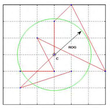
19 The distribution of the ROG covered with 869,992 mobile phone users. Radius of gyration

20 Gender
21 Distance Decay Effect in different cities Kang, C., Ma, X., Tong, D., & Liu, Y. (2012). Intra-urban human mobility patterns: An urban morphology perspective. Physica A: Statistical Mechanics and its Applications, 391(4),
22 Urban Structure
23 Spatial Structure 1) Land-use type 2) Population distribution 3) Transportation (accessibility) 4) Function division (POIs) 5) Intersections (flow, mobility)
24 Urban Structure Aggregate approach (Hourly) --Cell i (volume00, volume01, volume02, volume23) The scale of the urban area, may including the city and some inner suburbs, to highlight interesting metropolitan dynamics Calculate the kernel density Song Gao, UCSB Geography, 2013


25 Spatio-temporal patterns Mobile Landscape AM AM AM PM PM PM Song Gao, UCSB Geography, 2013

26 Mobile Landscape: People of MIT SENSEable City Lab have developed a continuously changing real-time maps of cell phone usage in Graz, Austria.


27 Correlation with population distribution r= r= AM AM r= r= r= PM PM PM Song Gao, UCSB Geography, 2013
28 Urban Transportation
. Structure of urban movements: polycentric activity and entangled hierarchical flows. PLoS One,6(1), e15923.")
29 Identifying the Structure of Urban Movements from Smart Card Data Roth, C., Kang, S. M., Batty, M., & Barthélemy, M. (2011). Structure of urban movements: polycentric activity and entangled hierarchical flows. PLoS One,6(1), e15923.


30 Analyzing jobs-housing relationships Long Y, Thill J-C, 2013, Combining smart card data, household travel survey and land use pattern for identifying housingjobs relationships in Beijing Computers, Environment and Urban Systems.
.")

31 Exploring Urban Land Use from GPS-enabled Taxi Trajectory Liu, Y., Wang, F., Xiao, Y., & Gao, S. (2012). Urban land uses and traffic source-sink areas : Evidence from GPS-enabled taxi data in Shanghai. Landscape and Urban Planning, 106(1),
.")

32 Exploring Urban Land Use from GPS-enabled Taxi Trajectory Liu, Y., Wang, F., Xiao, Y., & Gao, S. (2012). Urban land uses and traffic source-sink areas : Evidence from GPS-enabled taxi data in Shanghai. Landscape and Urban Planning, 106(1),


.")


33 Understanding urban traffic flow characteristics and street centrality Gao, S., Wang, Y., Gao, Y., & Liu, Y. (2013). Understanding urban trafficflow characteristics: a rethinking of betweenness centrality. Environment and Planning B: Planning and Design, 40(1),
34 Urban Air Quality

35 2PM, June 17, 2013 Yu Zheng Lead Researcher, Microsoft Research Asia


36 Inferring Real-Time and Fine-Grained air quality throughout a city using Big Data Yu Zheng Lead Researcher, Microsoft Research Asia Meteorology Traffic Human Mobility POIs Road networks Historical air quality data Real-time air quality reports
37 Spatial Interaction Network

38 Community in spatial networks Spatial Networks describe the networks in which the nodes are embedded in a geographical space Goal: to explore telecommunication flow in geographic space and to understand how the spatial context affect such interactions Song Gao, UCSB Geography, 2013
39 Community in spatial networks Spatial effects on networks (1) Spatial constraints on the distribution of nodes embedded in geographical locations; (2) Physical networks like roads and railways, which are affected by spatial topology; (3) Restrictions on long-distance links due to economic costs.


40 Motivation Whether interaction structure, friendship likelihoods reveal political boundaries, physical barriers, or social divide


41 3 AM 6 AM Temporal phone-call flow interactions 12 PM 21 PM by Song Gao
42 Distance Decay of Spatial Interactions P d G_TeleFlow G_MoveFlow the power-law fit with a decay parameter β=1.45 the power-law fit with a decay parameter β=1.60 Gao, S., Liu, Y., Wang, Y., & Ma, X. (2013). Discovering Spatial Interaction Communities from Mobile Phone Data. Transactions in GIS.

43 Community Detection in Spatial Networks The nodes of the network can be grouped into sets of nodes so that each community is densely connected internally. Modularity maximization Minimum-cut method Hierarchical clustering Girvan Newman algorithm Clique based methods Modularity is defined as the sum of differences between the fraction of edges falling within communities and the expected value of the same quantity under the random null model. Song Gao, UCSB Geography, 2013


44 Community detection results MAXID-----: 616 NUMNODES--: 609 NUMEDGES--: TOTALWT---: NUMGROUPS-: 10 MINSIZE---: 27 MEANSIZE--: 60.9 MAXSIZE---: 120 MAXQ------: STEP------: 599

 of")
45 Examples of differentiated geographical context of isolated regions in spatial communities Cell A locates in the overpass intersection of ring highway and the airport expressway which is near a large residential suburb area of this city, and a high volume of call interaction make it merged to the northern spatial community (yellow) of official cells.

46 Examples of differentiated geographical context of isolated regions in spatial communities Cell B has been grouped into the same distant community on Monday, Thursday and Friday, whereas it aggregates into nearby spatial adjacent community on weekends. It corresponds to a set of governmental buildings which has strong connections with eastern cells (green) of central business district on weekdays.
 - 增强 (Stimulation) - 缓和 (Modificaiton) a causal relationship?")
47 Relation between Telecommunication and Movement Correlation coefficients between phone call interaction and movements Mon Tue Wed Thur Fri Sat Sun R ICT & Mobility: - 替代 (Substitution) - 增强 (Stimulation) - 缓和 (Modificaiton) a causal relationship? Song Gao, UCSB Geography, 2013
48 Why spatial is special Urban Computing Outline Geospatial Data Conflation GIS Trends Conclusions


49 The Big-Data Age: more geospatial data Authoritative sources US Census TIGER files USGS NGA State and local governments Geospatial data companies Assertive sources VGI: OpenStreetMap, Wikimapia Social Media: Twitter, Flickr, Foursquare

50 Geospatial Data conflation Map conflation: a combining of two digital map files to produce a third map file which is better than each of the component source maps -- Lynch and Saalfeld, 1985 Geographic data conflation: a process of combining information from two or more related geospatial datasets, and thus acquiring knowledge that cannot be obtained from any single data source alone. Point of Interest (POIs) conflation: enriching and updating business POIs
51 Feature matching framework Feature matching: integration of all possible characteristics Geometry: Euclidean distance, Hausdorff distance, nearest neighbor pairing, shape (Saalfeld, 1988; Yuan and Tao, 1999;Filin and Doytsher, 2000; Chen, et al., 2006; Hastings, 2008) Semantics: feature name, feature type, and other general information (Cohen et al. 2003; Hastings, 2008) Topology: connectivity of lines (Saalfeld, 1988 ; Filin and Doytsher, 2000)
52 A generic model for linear feature matching Two directed Hausdorff distances d d DH i j DH j i max{ d( x, L x L x L i max{ d( x, L j i j )} )} The shortest distance between a point x and a line L d( x, L) min{ d( x, y): y L}
53 Greedy or Optimization in feature matching Input data Greedy Optimization Optimization
54 Optimized linear feature matching in geographic data Objective function: Maximize k l i 1 j 1 s i z j i j z i j 1, if a match is made from feature i to j 0, otherwise Constraints: l j 1 z i 1, i z 1 j j k i 1 i j j, 1, if all similarities of feature j 0, otherwise k i 1 l i * zi j k j *, j j areless than a certain value li the length of feature i in Dataset 1 k j the length of feature j in Dataset 2 a tolerance factor that takes into account uncertainty in feature length Linna Li and Michael F. Goodchild. An optimisation model for linear feature matching in geographical data conflation. International Journal of Image and Data Fusion 2(4):


55 Test areas Test Area 1 Test Area 2 Test Area 3 Test Area 4
56 Results of optimized feature matching Test Area Test Area 1 Test Area 2 Test Area 3 Test Area 4 Total Number of features in Dataset Number of features in Dataset Number of corresponding pairs and singles Number of correct identifications Percentage of correct identifications 98.00% 97.58% 97.85% 95.03% 97.18%


57 Comparison between our conflation tool (green) and three other tools Results provided by NGA

58 Feature Conflation Toolbox in ArcGIS by Song Gao

59 The command line for batch processing
60 Speeding up the algorithm Time consuming: Calculation of Hausdorff distance matrix between linear features Divide-and-conquer Divide the whole dataset into smaller sub-datasets Parallel computing
61 Partitioning for Parallel Computing (1) Quadtree-Based Approach
62 Partitioning for Parallel Computing (2) Sweeping-Based Approach
63 Partitioning for Parallel Computing (3) Object-Based Approach L1 L2 L3 L4 L5 L6 Asymmetric Hausdorff Distance Matrix O(n 2 ) L1 d12 d13 d14 d15 d16 L2 d21 d23 d24 d25 d26 L3 d31 d32 d34 d35 d36 L4 d41 d42 d43 d45 d46 L5 d51 d52 d53 d54 d56 L6 d61 d62 d63 d64 d65

64
65 Comparing the computation time between Hadoop-based spatial join and PC-based approach Gao. S., Li, L., & Goodchild, M. A Scalable Geoprocessing Workflow for Big Geo-Data Analysis and Optimized Geospatial Feature Conflation based on Hadoop. In NSF CyberGIS AHM'13, Sept , 2013, Seattle, WA, USA. Gao, S., Li, L., Li, W., Janowicz, K., & Zhang, Y. Constructing Gazetteers from Volunteered Geographic Information Based on Hadoop. (submitted to Computers, Environment and Urban Systems. 2014)
66 Why spatial is special Urban Computing Outline Geospatial Data Conflation GIS Trends Conclusions

67 Online (Cloud) GIS Access GIS techniques without installing any software on your computers.
")
68 Online (Cloud) GIS

69 (Moxie Zhang at Esri Beijing Lab)

70 (Moxie Zhang at Esri Beijing Lab)


71 Mobile GIS

72 Location-Based Events Create actions based on where you are.

73 Esri Mobile API allows developers to build location-aware applications without having to write code from scratch. Developers can easily add automatic check-ins, user signups, location-based messaging, event triggers, and real-time GPS maps to their existing applications. Individual Geotrigger notifications are automatically pushed to mobile users upon crossing a Geofence
74 What about GIScience?


75 The National Center for Geographic Information and Analysis (NCGIA) 2013 Maine Meeting UCSB, SUNY Buffalo, Maine
76 New kinds of data Big Geo-Data Closer to real-time Vastly increased volume Poor and diminishing quality control from disparate sources no lengthy synthesis by experts no metadata or provenance Need to automate quality control and the production of metadata and provenance
77 The Characteristics of Big Data Volume tera-, peta-, exabyte scale zetta (10 21 ) yotta (10 24 ) the mass of the Earth is 5,973.6 Yg Velocity rapid change, speed of analysis Variety many sources varied quality
78 New kinds of analysis Of data with unknown or variable quality More suited to hypothesis generation than hypothesis testing The softer end of science Exploration, sampling design Induction Qualitative and Quantitative An increased role for machine learning and data mining

79 NSF Funding Project: CyberGIS

80 CyberGIS

81


82 GeoDesign


83 UCSB SeaSketch GeoDesign for the Oceans EXPRESS Ideas and Opinions In The Form of Sketches EVALUATE Plans Based on Science DISCUSS The Merits of Design

84 Space-Time GIS
85

86 Human Mobility and Diseases Spreading Balcan, D., Colizza, V., Gonçalves, B., Hu, H., Ramasco, J. J., & Vespignani, A. (2009). Multiscale mobility networks and the spatial spreading of infectious diseases. Proceedings of the National Academy of Sciences, 106(51),

87

88 Volunteered Geographic Information (VGI) Citizens as sensors: the world of volunteered geography by Professor Michael F. Goodchild


89 Typhoon Haiyan/Yolanda GIS

90 OpenStreetMap Edits in US Created by ITO World

91 Mapping Social Media by Paul Butler

92 Hurricane Sandy Tweetbeat SGI

93 Crandall et al Mapping the world s photos.

94 Dots Yellow: Photos Blue: Tweets White: Both by Erik Fischer
 See also http://www.flickr.")
95 Tracks inferred from Flickr postings ( See also
96 Why spatial is special Urban Computing Outline Geospatial Data Conflation GIS Trends Conclusions

97

98
99 Spatial is special, To know the unknown!


100
Detecting Origin-Destination Mobility Flows From Geotagged Tweets in Greater Los Angeles Area
 Detecting Origin-Destination Mobility Flows From Geotagged Tweets in Greater Los Angeles Area Song Gao 1, Jiue-An Yang 1,2, Bo Yan 1, Yingjie Hu 1, Krzysztof Janowicz 1, Grant McKenzie 1 1 STKO Lab, Department
Uncovering the Digital Divide and the Physical Divide in Senegal Using Mobile Phone Data
 Uncovering the Digital Divide and the Physical Divide in Senegal Using Mobile Phone Data Song Gao, Bo Yan, Li Gong, Blake Regalia, Yiting Ju, Yingjie Hu STKO Lab, Department of Geography, University of
Exploring the Patterns of Human Mobility Using Heterogeneous Traffic Trajectory Data
 Exploring the Patterns of Human Mobility Using Heterogeneous Traffic Trajectory Data Jinzhong Wang April 13, 2016 The UBD Group Mobile and Social Computing Laboratory School of Software, Dalian University
A General Framework for Conflation
 A General Framework for Conflation Benjamin Adams, Linna Li, Martin Raubal, Michael F. Goodchild University of California, Santa Barbara, CA, USA Email: badams@cs.ucsb.edu, linna@geog.ucsb.edu, raubal@geog.ucsb.edu,
Bus Landscapes: Analyzing Commuting Pattern using Bus Smart Card Data in Beijing
 Bus Landscapes: Analyzing Commuting Pattern using Bus Smart Card Data in Beijing Ying Long, Beijing Institute of City Planning 龙瀛 Jean-Claude Thill, The University of North Carolina at Charlotte 1 INTRODUCTION
Space-adjusting Technologies and the Social Ecologies of Place
 Space-adjusting Technologies and the Social Ecologies of Place Donald G. Janelle University of California, Santa Barbara Reflections on Geographic Information Science Session in Honor of Michael Goodchild
Encapsulating Urban Traffic Rhythms into Road Networks
 Encapsulating Urban Traffic Rhythms into Road Networks Junjie Wang +, Dong Wei +, Kun He, Hang Gong, Pu Wang * School of Traffic and Transportation Engineering, Central South University, Changsha, Hunan,
Discovering Urban Spatial-Temporal Structure from Human Activity Patterns
 ACM SIGKDD International Workshop on Urban Computing (UrbComp 2012) Discovering Urban Spatial-Temporal Structure from Human Activity Patterns Shan Jiang, shanjang@mit.edu Joseph Ferreira, Jr., jf@mit.edu
Geographic Information Systems and Science: Today and Tomorrow. Michael F. Goodchild University of California Santa Barbara
 Geographic Information Systems and Science: Today and Tomorrow Michael F. Goodchild University of California Santa Barbara Geospatial technologies Positioning on the Earth s surface GPS, RFID Acquisition
The Future of Geography in an. Society. Michael F. Goodchild University of California Santa Barbara
 The Future of Geography in an Emerging Information-Technology Society Michael F. Goodchild University of California Santa Barbara Geographic technologies Positioning i on the Earth s surface GPS, RFID
City monitoring with travel demand momentum vector fields: theoretical and empirical findings
 City monitoring with travel demand momentum vector fields: theoretical and empirical findings Xintao Liu 1, Joseph Y.J. Chow 2 1 Department of Civil Engineering, Ryerson University, Canada 2 Tandon School
A spatial literacy initiative for undergraduate education at UCSB
 A spatial literacy initiative for undergraduate education at UCSB Mike Goodchild & Don Janelle Department of Geography / spatial@ucsb University of California, Santa Barbara ThinkSpatial Brown bag forum
Reproducible AGILE
 Reproducible Research @ AGILE The term Reproducible Research refers to the idea that the ultimate product of academic research is a scientific paper published along with the data, methods and full computational
Spatial Data, Spatial Analysis and Spatial Data Science
 Spatial Data, Spatial Analysis and Spatial Data Science Luc Anselin http://spatial.uchicago.edu 1 spatial thinking in the social sciences spatial analysis spatial data science spatial data types and research
Exploring Urban Areas of Interest. Yingjie Hu and Sathya Prasad
 Exploring Urban Areas of Interest Yingjie Hu and Sathya Prasad What is Urban Areas of Interest (AOIs)? What is Urban Areas of Interest (AOIs)? Urban AOIs exist in people s minds and defined by people s
Cartographic and Geospatial Futures
 Cartographic and Geospatial Futures 1. Web Cartography, WebGIS, & Virtual Globes--New Roles for Maps, GIS, and GIS professionals 2. Map Mashups, the Neo Neo-geography Movement, & Crowd-sourcing Geospatial
An Ontology-based Framework for Modeling Movement on a Smart Campus
 An Ontology-based Framework for Modeling Movement on a Smart Campus Junchuan Fan 1, Kathleen Stewart 1 1 Department of Geographical and Sustainability Sciences, University of Iowa, Iowa City, IA, 52242,
A Cloud Computing Workflow for Scalable Integration of Remote Sensing and Social Media Data in Urban Studies
 A Cloud Computing Workflow for Scalable Integration of Remote Sensing and Social Media Data in Urban Studies Aiman Soliman1, Kiumars Soltani1, Junjun Yin1, Balaji Subramaniam2, Pierre Riteau2, Kate Keahey2,
Exploring spatial decay effect in mass media and social media: a case study of China
 Exploring spatial decay effect in mass media and social media: a case study of China 1. Introduction Yihong Yuan Department of Geography, Texas State University, San Marcos, TX, USA, 78666. Tel: +1(512)-245-3208
Building a Vibrant and Enduring Spatial Science John P. Wilson IWGIS2014 Beijing, China
 Building a Vibrant and Enduring Spatial Science John P. Wilson IWGIS2014 Beijing, China Outline Spatial roots o Geography o Landscape architecture o Computer science The (current) opportunity Guiding principles
Spatial Epidemic Modelling in Social Networks
 Spatial Epidemic Modelling in Social Networks Joana Margarida Simoes Centre for Advanced Spatial Analysis, University College of London, UK Abstract. The spread of infectious diseases is highly influenced
Diagnosing New York City s Noises with Ubiquitous Data
 Diagnosing New York City s Noises with Ubiquitous Data Dr. Yu Zheng yuzheng@microsoft.com Lead Researcher, Microsoft Research Chair Professor at Shanghai Jiao Tong University Background Many cities suffer
GIS and Spatial Statistics: One World View or Two? Michael F. Goodchild University of California Santa Barbara
 GIS and Spatial Statistics: One World View or Two? Michael F. Goodchild University of California Santa Barbara Location as attribute The data table Census summary table What value is location as an explanatory
Towards data driven decision-making using crowd-sourced geographic information. Linna Li University of Redlands December 2, 2015
 Towards data driven decision-making using crowd-sourced geographic information Linna Li (linna.li@csulb.edu) University of Redlands December 2, 2015 WalMap: Walgreens store location map Geographic information
VISUAL EXPLORATION OF SPATIAL-TEMPORAL TRAFFIC CONGESTION PATTERNS USING FLOATING CAR DATA. Candra Kartika 2015
 VISUAL EXPLORATION OF SPATIAL-TEMPORAL TRAFFIC CONGESTION PATTERNS USING FLOATING CAR DATA Candra Kartika 2015 OVERVIEW Motivation Background and State of The Art Test data Visualization methods Result
PATREC PERSPECTIVES Sensing Technology Innovations for Tracking Congestion
 PATREC PERSPECTIVES Sensing Technology Innovations for Tracking Congestion Drivers have increasingly been using inexpensive mapping applications imbedded into mobile devices (like Google Maps, MapFactor,
Planning in a Geospatially Enabled Society. Michael F. Goodchild University of California Santa Barbara
 Planning in a Geospatially Enabled Society Michael F. Goodchild University of California Santa Barbara What is a geospatially enabled society? Knowing the locations of all points of interest and their
Cognitive Engineering for Geographic Information Science
 Cognitive Engineering for Geographic Information Science Martin Raubal Department of Geography, UCSB raubal@geog.ucsb.edu 21 Jan 2009 ThinkSpatial, UCSB 1 GIScience Motivation systematic study of all aspects
Place Syntax Tool (PST)
") Place Syntax Tool (PST) Alexander Ståhle To cite this report: Alexander Ståhle (2012) Place Syntax Tool (PST), in Angela Hull, Cecília Silva and Luca Bertolini (Eds.) Accessibility Instruments for Planning
Place Syntax Tool (PST) Alexander Ståhle To cite this report: Alexander Ståhle (2012) Place Syntax Tool (PST), in Angela Hull, Cecília Silva and Luca Bertolini (Eds.) Accessibility Instruments for Planning
Geographical Bias on Social Media and Geo-Local Contents System with Mobile Devices
 212 45th Hawaii International Conference on System Sciences Geographical Bias on Social Media and Geo-Local Contents System with Mobile Devices Kazunari Ishida Hiroshima Institute of Technology k.ishida.p7@it-hiroshima.ac.jp
Exploring Human Mobility with Multi-Source Data at Extremely Large Metropolitan Scales. ACM MobiCom 2014, Maui, HI
 Exploring Human Mobility with Multi-Source Data at Extremely Large Metropolitan Scales Desheng Zhang & Tian He University of Minnesota, USA Jun Huang, Ye Li, Fan Zhang, Chengzhong Xu Shenzhen Institute
California Reality and Nova Scotia Dreaming. Michael F. Goodchild University of California Santa Barbara
 California Reality and Nova Scotia Dreaming Michael F. Goodchild University of California Santa Barbara 1 The geospatial world Remote sensing Geographic information systems Automated cartography Global
Towards Geographic Information Observatories
 Towards Geographic Information Observatories Krzysztof Janowicz 1, Benjamin Adams 2, Grant McKenzie 1, and Tomi Kauppinen 3,4 1 University of California, Santa Barbara, USA 2 The University of Auckland,
Generalisation and Multiple Representation of Location-Based Social Media Data
 Generalisation and Multiple Representation of Location-Based Social Media Data Dirk Burghardt, Alexander Dunkel and Mathias Gröbe, Institute of Cartography Outline 1. Motivation VGI and spatial data from
Spatial Data Science. Soumya K Ghosh
 Workshop on Data Science and Machine Learning (DSML 17) ISI Kolkata, March 28-31, 2017 Spatial Data Science Soumya K Ghosh Professor Department of Computer Science and Engineering Indian Institute of Technology,
DM-Group Meeting. Subhodip Biswas 10/16/2014
 DM-Group Meeting Subhodip Biswas 10/16/2014 Papers to be discussed 1. Crowdsourcing Land Use Maps via Twitter Vanessa Frias-Martinez and Enrique Frias-Martinez in KDD 2014 2. Tracking Climate Change Opinions
Curriculum Vitae. Dr. Danqing (Dana) Xiao. Ph.D. in Department of Geography, University of California Santa Barbara.
 Xiao. Ph.D. in Department of Geography, University of California Santa Barbara.") Curriculum Vitae Dr. Danqing (Dana) Xiao Personal Information Assistant Professor Department of Environmental, Geographical, and Geological Sciences (EGGS), Bloomsburg University of Pennsylvania Research
Curriculum Vitae Dr. Danqing (Dana) Xiao Personal Information Assistant Professor Department of Environmental, Geographical, and Geological Sciences (EGGS), Bloomsburg University of Pennsylvania Research
VGIscience Summer School Interpretation, Visualisation and Social Computing of Volunteered Geographic Information (VGI)
") VGIscience Summer School Interpretation, Visualisation and Social Computing of Volunteered Geographic Information (VGI) TU Dresden, 11.-15. September 2017 Welcome PhD students working on research topics
VGIscience Summer School Interpretation, Visualisation and Social Computing of Volunteered Geographic Information (VGI) TU Dresden, 11.-15. September 2017 Welcome PhD students working on research topics
Reimaging GIS: Geographic Information Society. Clint Brown Linda Beale Mark Harrower Esri
 Reimaging GIS: Geographic Information Society Clint Brown Linda Beale Mark Harrower Esri 8 billion = Number of basemap requests per month on AGOL 14,000 = Unique requests per second 12,000 = New Items
ESRI Survey Summit August Clint Brown Director of ESRI Software Products
 ESRI Survey Summit August 2006 Clint Brown Director of ESRI Software Products Cadastral Fabric How does Cadastral fit with Survey? Surveyors process raw field observations Survey measurements define high-order
GIScience: Current Technology. Michael F. Goodchild University of California Santa Barbara
 GIScience: Current Technology Michael F. Goodchild University of California Santa Barbara What is a GIS? A class of software designed to handle geographic information and perform virtually any conceivable
Clustering Analysis of London Police Foot Patrol Behaviour from Raw Trajectories
 Clustering Analysis of London Police Foot Patrol Behaviour from Raw Trajectories Jianan Shen 1, Tao Cheng 2 1 SpaceTimeLab for Big Data Analytics, Department of Civil, Environmental and Geomatic Engineering,
CyberGIS: What Still Needs to Be Done? Michael F. Goodchild University of California Santa Barbara
 CyberGIS: What Still Needs to Be Done? Michael F. Goodchild University of California Santa Barbara Progress to date Interoperable location referencing coordinate transformations geocoding addresses point-of-interest
GIScience & Mobility. Prof. Dr. Martin Raubal. Institute of Cartography and Geoinformation SAGEO 2013 Brest, France
 GIScience & Mobility Prof. Dr. Martin Raubal Institute of Cartography and Geoinformation mraubal@ethz.ch SAGEO 2013 Brest, France 25.09.2013 1 www.woodsbagot.com 25.09.2013 2 GIScience & Mobility Modeling
ArcGIS for Desktop. ArcGIS for Desktop is the primary authoring tool for the ArcGIS platform.
 ArcGIS for Desktop ArcGIS for Desktop ArcGIS for Desktop is the primary authoring tool for the ArcGIS platform. Beyond showing your data as points on a map, ArcGIS for Desktop gives you the power to manage
Lecture 9: Geocoding & Network Analysis
 Massachusetts Institute of Technology - Department of Urban Studies and Planning 11.520: A Workshop on Geographic Information Systems 11.188: Urban Planning and Social Science Laboratory Lecture 9: Geocoding
Twenty Years of Progress: GIScience in Michael F. Goodchild University of California Santa Barbara
 Twenty Years of Progress: GIScience in 2010 Michael F. Goodchild University of California Santa Barbara Outline The beginnings: GIScience in 1990 Major accomplishments research institutional The future
Exploring Urban Mobility from Taxi Trajectories: A Case Study of Nanjing, China
 Exploring Urban Mobility from Taxi Trajectories: A Case Study of Nanjing, China Yihong Yuan and Maël Le Noc Department of Geography, Texas State University, San Marcos, TX, U.S.A. {yuan, mael.lenoc}@txstate.edu
Michael Harrigan Office hours: Fridays 2:00-4:00pm Holden Hall
 Announcement New Teaching Assistant Michael Harrigan Office hours: Fridays 2:00-4:00pm Holden Hall 209 Email: michael.harrigan@ttu.edu Guofeng Cao, Texas Tech GIST4302/5302, Lecture 2: Review of Map Projection
Discovery and Access of Geospatial Resources using the Geoportal Extension. Marten Hogeweg Geoportal Extension Product Manager
 Discovery and Access of Geospatial Resources using the Geoportal Extension Marten Hogeweg Geoportal Extension Product Manager DISCOVERY AND ACCESS USING THE GEOPORTAL EXTENSION Geospatial Data Is Very
Application of GIS in Public Transportation Case-study: Almada, Portugal
 Case-study: Almada, Portugal Doutor Jorge Ferreira 1 FSCH/UNL Av Berna 26 C 1069-061 Lisboa, Portugal +351 21 7908300 jr.ferreira@fcsh.unl.pt 2 FSCH/UNL Dra. FCSH/UNL +351 914693843, leite.ines@gmail.com
Demographic Data in ArcGIS. Harry J. Moore IV
 Demographic Data in ArcGIS Harry J. Moore IV Outline What is demographic data? Esri Demographic data - Real world examples with GIS - Redistricting - Emergency Preparedness - Economic Development Next
Exploiting Geographic Dependencies for Real Estate Appraisal
 Exploiting Geographic Dependencies for Real Estate Appraisal Yanjie Fu Joint work with Hui Xiong, Yu Zheng, Yong Ge, Zhihua Zhou, Zijun Yao Rutgers, the State University of New Jersey Microsoft Research
ArcGIS Platform For NSOs
 ArcGIS Platform For NSOs Applying GIS and Spatial Thinking to Official Statistics Esri UC 2014 Demo Theater Applying GIS at the NSO Generic Statistical Business Process Model (GSBPM) 1 Specify Needs 2
GIS Level 2. MIT GIS Services
 GIS Level 2 MIT GIS Services http://libraries.mit.edu/gis Email: gishelp@mit.edu TOOLS IN THIS WORKSHOP - Definition Queries - Create a new field in the attribute table - Field Calculator - Add XY Data
Visualizing Big Data on Maps: Emerging Tools and Techniques. Ilir Bejleri, Sanjay Ranka
 Visualizing Big Data on Maps: Emerging Tools and Techniques Ilir Bejleri, Sanjay Ranka Topics Web GIS Visualization Big Data GIS Performance Maps in Data Visualization Platforms Next: Web GIS Visualization
SPACE Workshop NSF NCGIA CSISS UCGIS SDSU. Aldstadt, Getis, Jankowski, Rey, Weeks SDSU F. Goodchild, M. Goodchild, Janelle, Rebich UCSB
 SPACE Workshop NSF NCGIA CSISS UCGIS SDSU Aldstadt, Getis, Jankowski, Rey, Weeks SDSU F. Goodchild, M. Goodchild, Janelle, Rebich UCSB August 2-8, 2004 San Diego State University Some Examples of Spatial
* Abstract. Keywords: Smart Card Data, Public Transportation, Land Use, Non-negative Matrix Factorization.
 Analysis of Activity Trends Based on Smart Card Data of Public Transportation T. N. Maeda* 1, J. Mori 1, F. Toriumi 1, H. Ohashi 1 1 The University of Tokyo, 7-3-1 Hongo Bunkyo-ku, Tokyo, Japan *Email:
1. Richard Milton 2. Steven Gray 3. Oliver O Brien Centre for Advanced Spatial Analysis (UCL)
") UCL CENTRE FOR ADVANCED SPATIAL ANALYSIS Apps Delivering Information to Mass Audiences 1. Richard Milton 2. Steven Gray 3. Oliver O Brien Centre for Advanced Spatial Analysis (UCL) Scott Adams 1995 The
UCL CENTRE FOR ADVANCED SPATIAL ANALYSIS Apps Delivering Information to Mass Audiences 1. Richard Milton 2. Steven Gray 3. Oliver O Brien Centre for Advanced Spatial Analysis (UCL) Scott Adams 1995 The
Exploring Urban Mobility from Taxi Trajectories: A Case Study of Nanjing, China
 Exploring Urban Mobility from Taxi Trajectories: A Case Study of Nanjing, China Yihong Yuan, Maël Le Noc Department of Geography, Texas State University,San Marcos, TX, USA {yuan, mael.lenoc}@ txstate.edu
Tools to Assess Local Health Needs. Richard Leadbeater, Esri NACo 2011 Healthy Counties Forum December 1, 2011
 Tools to Assess Local Health Needs Richard Leadbeater, Esri NACo 2011 Healthy Counties Forum December 1, 2011 Richard Leadbeater currently holds the position of Industry Solutions Manager with Esri. He
Outline. 15. Descriptive Summary, Design, and Inference. Descriptive summaries. Data mining. The centroid
 Outline 15. Descriptive Summary, Design, and Inference Geographic Information Systems and Science SECOND EDITION Paul A. Longley, Michael F. Goodchild, David J. Maguire, David W. Rhind 2005 John Wiley
IV Course Spring 14. Graduate Course. May 4th, Big Spatiotemporal Data Analytics & Visualization
 Spatiotemporal Data Visualization IV Course Spring 14 Graduate Course of UCAS May 4th, 2014 Outline What is spatiotemporal data? How to analyze spatiotemporal data? How to visualize spatiotemporal data?
June 19 Huntsville, Alabama 1
 June 19 Huntsville, Alabama 1 Real-Time Geospatial Data: The Fusion of PI and ArcGIS Enabling Smarter Facilities Management OSIsoft and Esri Mapping and Location Analytics Platform Supporting Your Use
Road & Railway Network Density Dataset at 1 km over the Belt and Road and Surround Region
 Journal of Global Change Data & Discovery. 2017, 1(4): 402-407 DOI:10.3974/geodp.2017.04.03 www.geodoi.ac.cn 2017 GCdataPR Global Change Research Data Publishing & Repository Road & Railway Network Density
WHAT IS GIS? Source: Longley et al (2005) Geographic Information Systems and Science. 2nd Edition. John Wiley and Sons Ltd.
 Geographic Information Systems and Science. 2nd Edition. John Wiley and Sons Ltd.") WHAT IS GIS? Geographical Information Systems (GIS) are a special class of information systems that keep track not only of events, activities, and things, but also of where these events, activities, and
WHAT IS GIS? Geographical Information Systems (GIS) are a special class of information systems that keep track not only of events, activities, and things, but also of where these events, activities, and
Geographic Data Science - Lecture II
 Geographic Data Science - Lecture II (New) Spatial Data Dani Arribas-Bel "Yesterday" Introduced the (geo-)data revolution What is it? Why now? The need of (geo-)data science to make sense of it all Today
Better Topographic Map Production Using ArcGIS. A Comprehensive Solution for Mapping Organizations
 Better Topographic Map Production Using ArcGIS A Comprehensive Solution for Mapping Organizations The World Is Always Changing As a member of a national mapping organization, you know this is true. You
ArcGIS is Advancing. Both Contributing and Integrating many new Innovations. IoT. Smart Mapping. Smart Devices Advanced Analytics
 ArcGIS is Advancing IoT Smart Devices Advanced Analytics Smart Mapping Real-Time Faster Computing Web Services Crowdsourcing Sensor Networks Both Contributing and Integrating many new Innovations ArcGIS
Esri and GIS Education
 Esri and GIS Education Organizations Esri Users 1,200 National Government Agencies 11,500 States & Regional Agencies 30,800 Cities & Local Governments 32,000 Businesses 8,500 Utilities 12,600 NGOs 11,000
DEKDIV: A Linked-Data-Driven Web Portal for Learning Analytics Data Enrichment, Interactive Visualization, and Knowledge Discovery
 DEKDIV: A Linked-Data-Driven Web Portal for Learning Analytics Data Enrichment, Interactive Visualization, and Knowledge Discovery Yingjie Hu, Grant McKenzie, Jiue-An Yang, Song Gao, Amin Abdalla, and
Assessing pervasive user-generated content to describe tourist dynamics
 Assessing pervasive user-generated content to describe tourist dynamics Fabien Girardin, Josep Blat Universitat Pompeu Fabra, Barcelona, Spain {Fabien.Girardin, Josep.Blat}@upf.edu Abstract. In recent
Urban Computing Using Big Data to Solve Urban Challenges
 Urban Computing Using Big Data to Solve Urban Challenges Dr. Yu Zheng Lead Researcher, Microsoft Research Asia Chair Professor at Shanghai Jiaotong University http://research.microsoft.com/en-us/projects/urbancomputing/default.aspx
Introduction to Spatial Statistics and Modeling for Regional Analysis
 Introduction to Spatial Statistics and Modeling for Regional Analysis Dr. Xinyue Ye, Assistant Professor Center for Regional Development (Department of Commerce EDA University Center) & School of Earth,
Designing smart & Resilient cities:
 Designing smart & Resilient cities: How can Egyptian cities learn from an emerging global practice On the Cuspof Change Professor Samer Bagaeen FRICS MRTPI FRSA AoU 1. GLOBAL CHALLENGES POPULATION GROWTH,
Nature of Spatial Data. Outline. Spatial Is Special
 Nature of Spatial Data Outline Spatial is special Bad news: the pitfalls of spatial data Good news: the potentials of spatial data Spatial Is Special Are spatial data special? Why spatial data require
A BASE SYSTEM FOR MICRO TRAFFIC SIMULATION USING THE GEOGRAPHICAL INFORMATION DATABASE
 A BASE SYSTEM FOR MICRO TRAFFIC SIMULATION USING THE GEOGRAPHICAL INFORMATION DATABASE Yan LI Ritsumeikan Asia Pacific University E-mail: yanli@apu.ac.jp 1 INTRODUCTION In the recent years, with the rapid
Surveying, Mapping and Remote Sensing (LIESMARS), Wuhan University, China
, Wuhan University, China") Name: Peng Yue Title: Professor and Director, Institute of Geospatial Information and Location Based Services (IGILBS) Associate Chair, Department of Geographic Information Engineering School of Remote
Name: Peng Yue Title: Professor and Director, Institute of Geospatial Information and Location Based Services (IGILBS) Associate Chair, Department of Geographic Information Engineering School of Remote
Exploring the Geography of Communities in Social Networks
 Exploring the Geography of Communities in Social Networks Alexis Comber 1, Michael Batty 2, Chris Brunsdon 3, Andrew Hudson-Smith 2, Fabian Neuhaus 2 and Steven Gray 2 1 Department of Geography, University
94-802Z: Geographic Information Systems Summer 2018
 94-802Z: Geographic Information Systems Summer 2018 Instructor: Professor Kristen Kurland Teaching Assistant(s): (Office hours to be posted on Canvas) TBA Class Web Site: http:/www.cmu.edu/canvas
Social and Technological Network Analysis: Spatial Networks, Mobility and Applications
 Social and Technological Network Analysis: Spatial Networks, Mobility and Applications Anastasios Noulas Computer Laboratory, University of Cambridge February 2015 Today s Outline 1. Introduction to spatial
Key Issue 1: Why Do Services Cluster Downtown?
 Key Issue 1: Why Do Services Cluster Downtown? Pages 460-465 1. Define the term CBD in one word. 2. List four characteristics of a typical CBD. Using your knowledge of services from chapter 12, define
1. INTRODUCTION 2. BIG DATA IN URBAN STUDIES 3. LESSONS FROM BIG DATA
 Main Content URBAN SENSING & COMPUTING Sensing and Computing Introduction and Application 王江浩 State Key Laboratory of Resources and Environmental Information System, Institute of Geographic Sciences and
Evaluating cities' vitality and identifying ghost cities in China with emerging geographical data
 Evaluating cities' vitality and identifying ghost cities in China with emerging geographical data Ying Long, Associate Professor School of Architecture, Tsinghua University, China November 14, 2016 In
GIS for ChEs Introduction to Geographic Information Systems
 GIS for ChEs Introduction to Geographic Information Systems AIChE Webinar John Cirucci 1 GIS for ChEs Introduction to Geographic Information Systems What is GIS? Tools and Methods Applications Examples
Using spatial-temporal signatures to infer human activities from personal trajectories on location-enabled mobile devices
 Using spatial-temporal signatures to infer human activities from personal trajectories on location-enabled mobile devices Yingjie Hu 1, Wenwen Li 2, Krzysztof Janowicz 1, Kathleen Deutsch 1, Grant McKenzie
geographic patterns and processes are captured and represented using computer technologies
 Proposed Certificate in Geographic Information Science Department of Geographical and Sustainability Sciences Submitted: November 9, 2016 Geographic information systems (GIS) capture the complex spatial
Welcome. C o n n e c t i n g
 Welcome C o n n e c t i n g YOU D i s c i p l i n e s Why is This Meeting......So Important Now? OUR WORLD Is Increasingly Challenged The Evidence Is Clear We Need Better Understanding and More Collaboration
Urban Computing Using Big Data to Solve Urban Challenges
 Urban Computing Using Big Data to Solve Urban Challenges Dr. Yu Zheng Lead Researcher, Microsoft Research Chair Professor at Shanghai Jiao Tong University http://research.microsoft.com/en-us/projects/urbancomputing/default.aspx
Health and Medical Geography (GEOG 222)
") Spring 2019 Class meets: Tuesdays and Thursdays 12:30-1:45pm Carolina Hall Room 220 Instructor: Michael Emch Email: emch@unc.edu Course Objectives Health and Medical Geography (GEOG 222) This course is
Spring 2019 Class meets: Tuesdays and Thursdays 12:30-1:45pm Carolina Hall Room 220 Instructor: Michael Emch Email: emch@unc.edu Course Objectives Health and Medical Geography (GEOG 222) This course is
2013 AND 2025 THE FUTURE OF GIS
 THE FUTURE OF GIS 2013 AND 2025 What is the state of geospatial computing today? What are the issues today? Unresolved problems What will geospatial computing be like in 2025? What issues will be of concern
SPATIAL ANALYSIS. Transformation. Cartogram Central. 14 & 15. Query, Measurement, Transformation, Descriptive Summary, Design, and Inference
 14 & 15. Query, Measurement, Transformation, Descriptive Summary, Design, and Inference Geographic Information Systems and Science SECOND EDITION Paul A. Longley, Michael F. Goodchild, David J. Maguire,
Urban GIS for Health Metrics
 Urban GIS for Health Metrics Dajun Dai Department of Geosciences, Georgia State University Atlanta, Georgia, United States Presented at International Conference on Urban Health, March 5 th, 2014 People,
Massachusetts Institute of Technology Department of Urban Studies and Planning
 Massachusetts Institute of Technology Department of Urban Studies and Planning 11.520: A Workshop on Geographic Information Systems 11.188: Urban Planning and Social Science Laboratory GIS Principles &
From Research Objects to Research Networks: Combining Spatial and Semantic Search
 From Research Objects to Research Networks: Combining Spatial and Semantic Search Sara Lafia 1 and Lisa Staehli 2 1 Department of Geography, UCSB, Santa Barbara, CA, USA 2 Institute of Cartography and
Friendship and Mobility: User Movement In Location-Based Social Networks. Eunjoon Cho* Seth A. Myers* Jure Leskovec
 Friendship and Mobility: User Movement In Location-Based Social Networks Eunjoon Cho* Seth A. Myers* Jure Leskovec Outline Introduction Related Work Data Observations from Data Model of Human Mobility
Merging statistics and geospatial information
 Merging statistics and geospatial information Demography / Commuting / Spatial planning / Registers Mirosław Migacz Chief GIS Specialist Janusz Dygaszewicz Director Central Statistical Office of Poland
TRAITS to put you on the map
 TRAITS to put you on the map Know what s where See the big picture Connect the dots Get it right Use where to say WOW Look around Spread the word Make it yours Finding your way Location is associated with
Mobility Analytics through Social and Personal Data. Pierre Senellart
 Mobility Analytics through Social and Personal Data Pierre Senellart Session: Big Data & Transport Business Convention on Big Data Université Paris-Saclay, 25 novembre 2015 Analyzing Transportation and
What is GIS? G: Geographic, Geospatial, Geo
 GEOG 488/588: GIS I Introduction Instructor: Geoffrey Duh TA: David Graves What is GIS? G: Geographic, Geospatial, Geo Alternatives: Spatial Information Systems, Land Information Systems Geography diverse