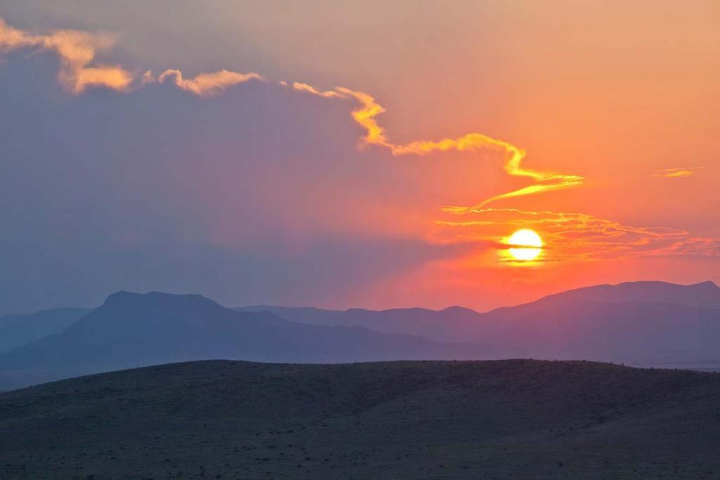
Randolph Ranch 12,164 Acres Brewster and Pecos Counties, Texas
|
|
|
- Adele Kimberly Strickland
- 5 years ago
- Views:
Transcription


1 Randolph Ranch 12,164 Acres Brewster and Pecos Counties, Texas James King, Agent Office Cell
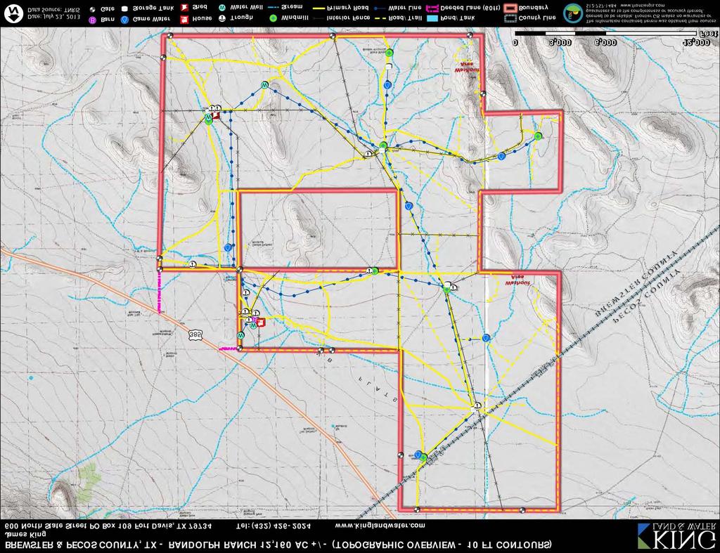
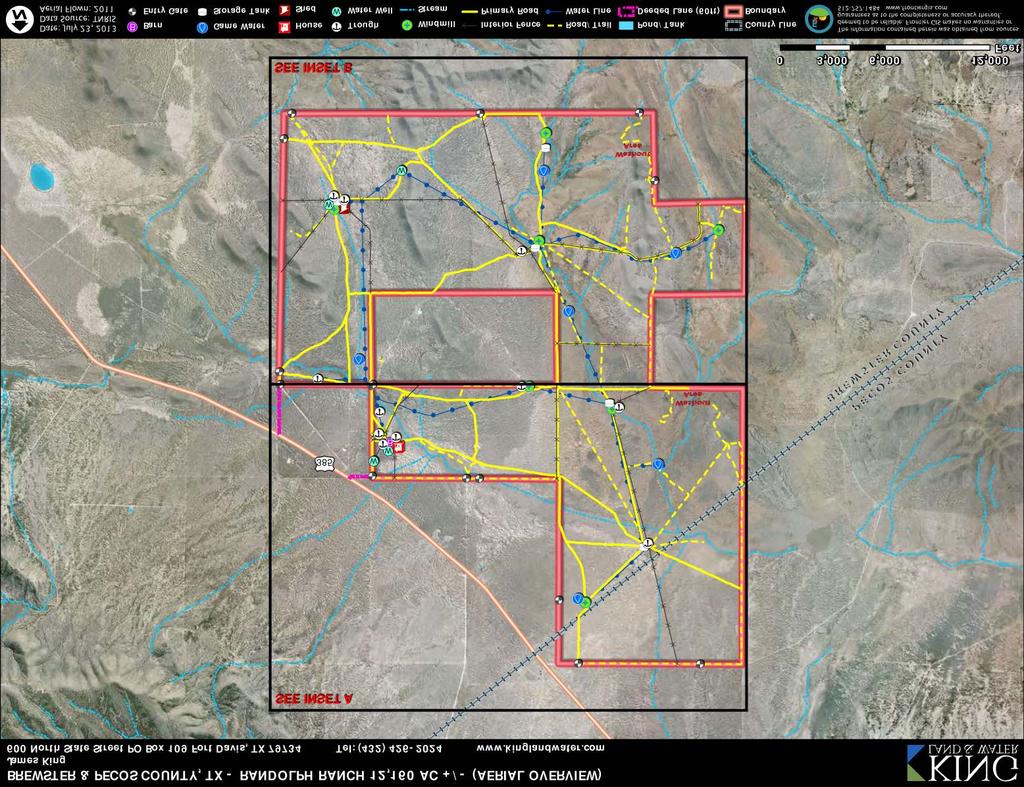
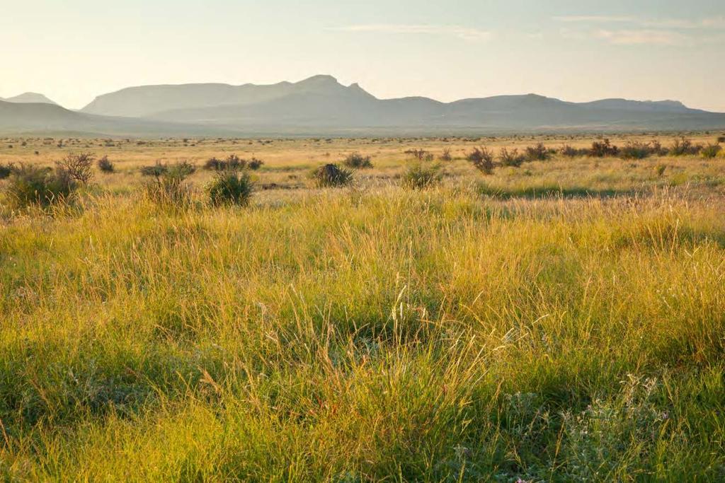
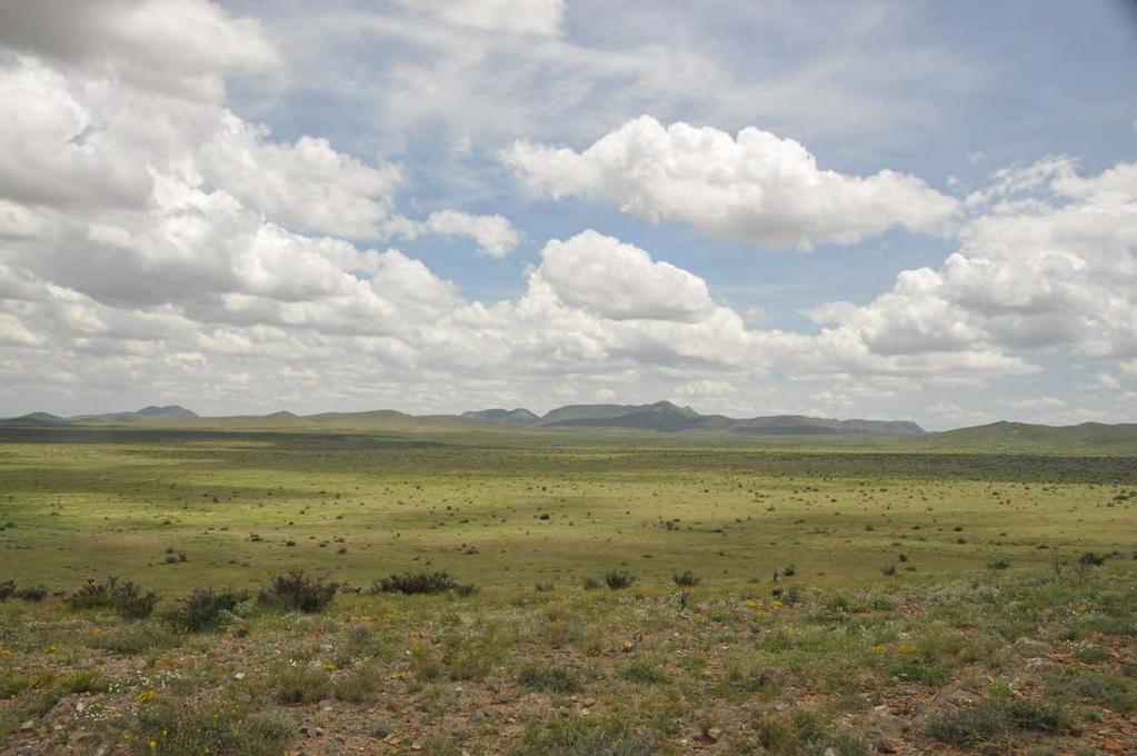
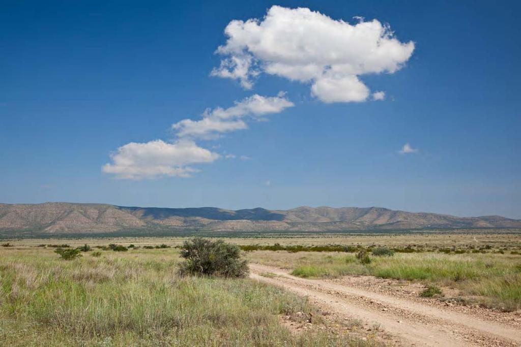
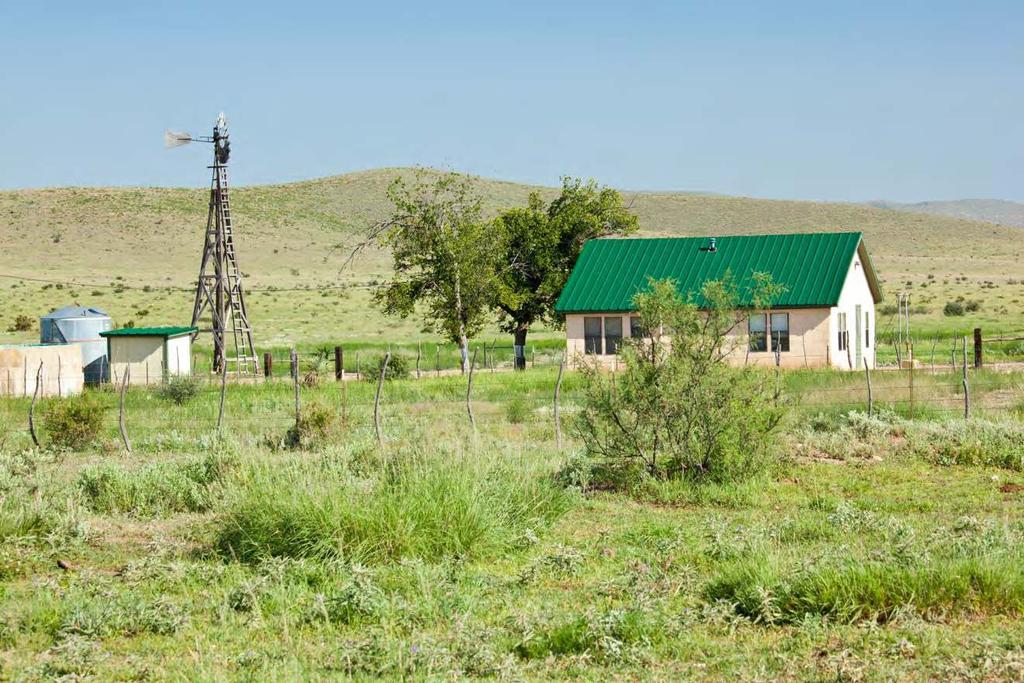
2 Randolph Ranch 12,164 Acres Brewster and Pecos Counties, Texas James King, Agent Office Location The ranch is located in the Marathon Basin 14 miles northeast of Marathon, the gateway to the Big Bend Country and home to the fabulous Gage Hotel and all its amenities. Randolph Ranch has two deeded ranch entrances on Highway 385 south of the Brewster-Pecos County line on the south side of the U.S. Highway. This is lush grassland extending into the foothills of the Glass Mountains, located on the eastern edge of the Trans-Pecos, making this ranch convenient to Austin, San Antonio and Midland-Odessa, with its airport only two hours away. Acreage 12, 164 acres in Brewster and Pecos Counties. History The Randolph Ranch is part of the historic Kincaid Ranch assembled by David S. Combs of the Texas pioneer Combs family in partnership with his brother-in-law s brother, Wm. D. (Billy) Kincaid, beginning in David S. Combs bought the Kincaid interest from Billy s widow, Cordelia, in The Ranch, named Kincaid Ranch by the Combs family, has been owned by descendants of David S. Combs until now and operated by them continuously from Description The Randolph Ranch is Texas cow country at its finest and represents some of the best grasslands in West Texas. The ranch is in a northeastern pocket of the Marathon Basin surrounded by mountains on three sides, producing an average of 14 of rainfall annually, one inch more than Marathon itself. It usually receives monsoon summer rains and has mild winters. Rainfall records for four rain gauges cover the period The topography of the ranch ranges from 4,100 feet along Big Canyon Draw to 4,700 feet at the top of the hills along the east boundary. It would be safe to say that this ranch has a gentle topography with some wide open valleys and flats to some very nice hills, all having excellent views of the Glass Mountains, Cedar Mountain and Stillwell Mountain and, from a rise on the south line, all the way to Santiago Peak to the south. The ranch has served as a laboratory for range recovery under its operation by the current owner for almost thirty years. A high-intensity, low-duration grazing system (Savory System) was employed from , which greatly accelerated the recovery of native range by natural means without use of any re-seeding or mechanical methods. This labor-intensive system, having served its purpose,
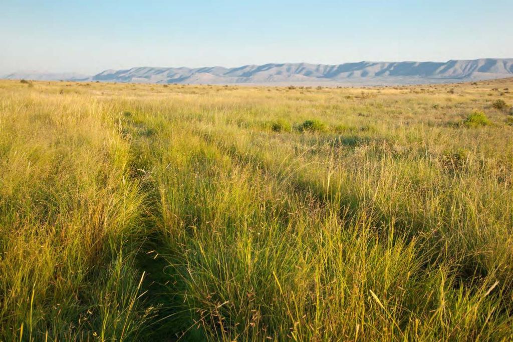
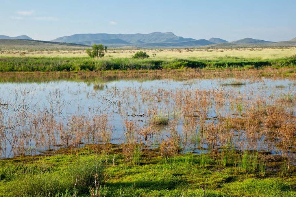
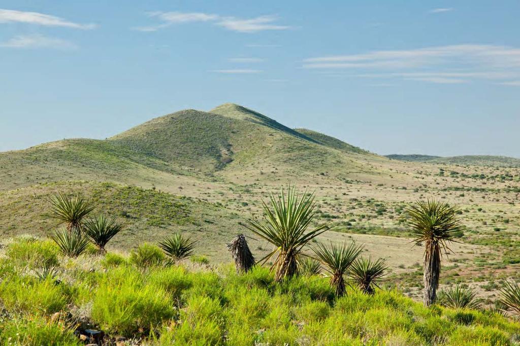
3 was replaced in 2011 with an eight-pasture rotation, which will allow the largely-recovered pastures to complete their recovery, if they are managed to do so. The condition of the forage has allowed English-breed cattle to achieve 45-day breeding seasons, producing steer calves averaging over 590# at weaning with breed-back conception rates over 95% on a consistent basis, even during droughts. During a series of good years a stocking rate of over 500 animal units (AU) was obtained while still continuing range improvement. This rate is considered exceptional when applied to average conditions, and normal stocking rates on this ranch for a cow-calf operation should run in the range of 300 AU, or 1 AU/40.5 acres, unusually productive in this part of the state. Higher rates in good years could be used in a steer operation. These stocking rates allow for continuation of range improvement. During the 2011 drought, believed to be the worst drought in this area since 1885, three-fourths of the ranch received only 2 ½ - 3 of rainfall during 16 months and never greened up in The remaining one-fourth received 3 ½ - 4 of rainfall, lower than any record for any other year since at least The grass grew, headed out and produced a small crop sufficient to graze 75 AU from February 1 st until late summer rains in The range improvement has been extraordinary. Beginning with the grasses typical of this area tobosa, alkali sacaton (salt grass), side oats grama, three awns and burro grass the native grasses have gradually reappeared from seed long hidden under brush or dormant in the ground and have spread over almost the entire ranch, with the higher succession grasses coming in as the conditions improved. First came silver blue stem and buffalo grass, followed by black grama, blue grama, and sand dropseed. Vinemesquite is found in the draws and has carpeted some of them solidly to a width of 150 yards or more. Muhly grass and vast quantities of plains bristlegrass have taken hold. Finally came Johnson grass and, during the last five years, one of the climax grasses of Texas, not generally thought ever to have existed in Brewster County, small clumps of big bluestem have also appeared, giving confirmation of the trend in the forage. Habitat The landscape is wide-open rolling grassland, interspersed with hills, all the way to the sky, surrounded by rugged mountain ranges which can be seen from anywhere on the ranch. Classic Cattle Country of the Old West, the Marathon Basin has maintained much of the environment and appearance of times past. This ranch lies at an elevation that supports a mix of vegetation from the mid-high Chihuahuan Desert such as century plants, Spanish dagger, yucca and cholla with a dominant grassland with areas of brush. Three major drainages cut through the ranch, which are collection points for grassland runoff during the summer monsoons, capturing water in thick grasscovered soil. This ranch, once predominantly bare ground, has had active management to heal the land with a growing cover of native grasslands that provide excellent forage for livestock as well as habitat for muledeer, pronghorn antelope, native birds and mammals. Wildlife This is Chihuahuan Desert grassland at its very best. The grasses, forbs and brush provide excellent habitat for game and non-game animals and birds. Muledeer, pronghorn antelope, prairie dogs, coyotes, javelina, bobcats and badgers are all present. Blue (scaled) quail and mourning dove are the game birds. Raptors include golden eagles and wide variety of hawks. Neotropical migratory birds such as oriels, hummingbirds, warblers, flycatchers, and many others make for a wonderful birding
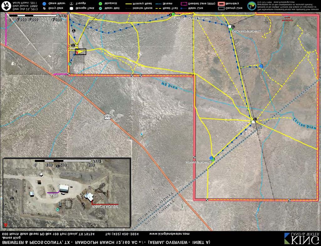
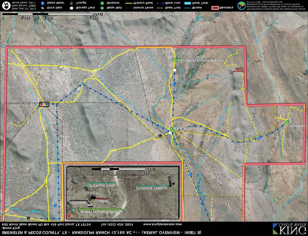
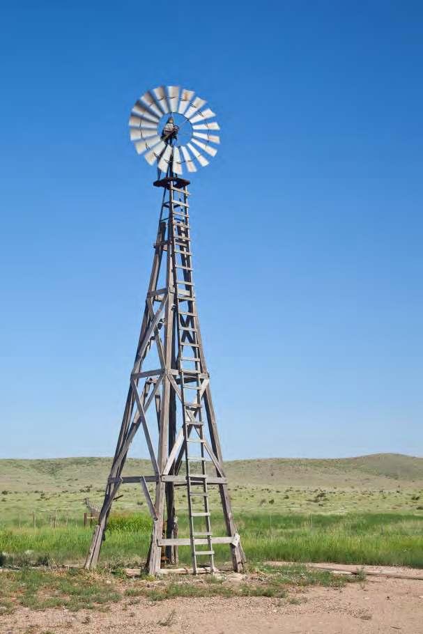
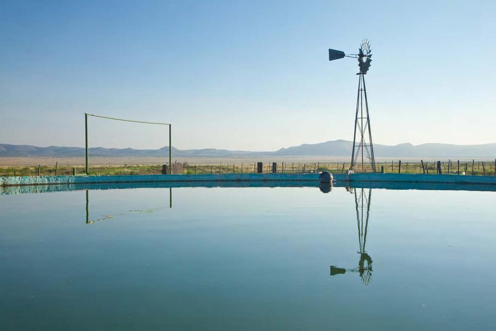
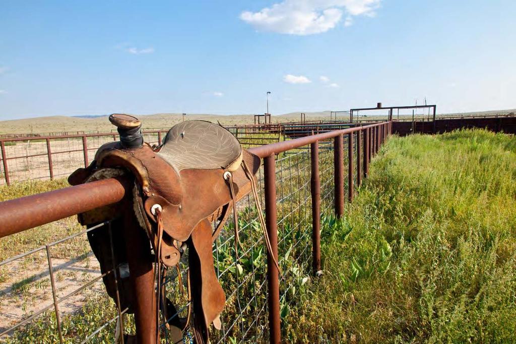
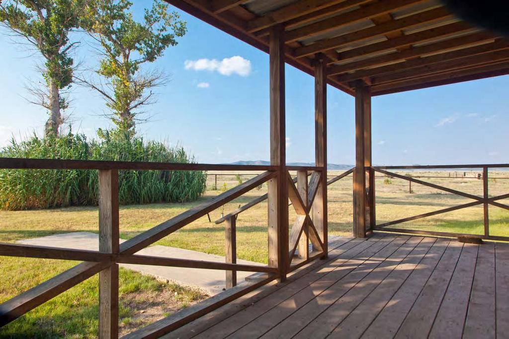
4 experience. The provision of year-round water over virtually all the ranch results in gradually increasing permanent grounds for game and consequent increase in their population. Improvements There are two Headquarters on the Randolph Ranch. The main ranch house, located on a hardsurfaced road ¾ mile off Highway 385, has three bedrooms, two baths, an office, kitchen, livingdining room, screen porch, open porch along the west side, and closed storage. A large metal barn contains a shop, tack room, and storage for equipment and feed with a partially-concreted floor. An extensive set of shipping traps, holding pens and welded pipe pens and chutes, contain a set of scales allowing sale of calves by private treaty, with a greatly reduced shrink. Steel sheet siding on the working chutes and loading chutes minimize stress on the cattle and loss of weight from being handled. Two overhead feed bins for cubes each hold 12 tons. In addition, there are two tanks for liquid feed with cover over them to protect the tanks from ultra-violet deterioration. A fenced garden is available. It is served by two submersible wells and a closed metal storage tank, which can provide back-up by gravity flow if electricity is lost. The Burnt House Headquarters is three miles off pavement on a hard-surfaced road. It includes an old cowboy house, renovated to serve as an owner s camp, which contains a living-dining room, kitchen, one bedroom, bath and dressing room. The windmill s wooden tower and the turning of the mill s fan provide an appropriate setting. Being so far removed from the road allows viewing of the sky without any light contamination whatsoever, with a view at night of occasional headlights coming soundlessly through Stockton Gap nine miles away on the road from Fort Stockton. A hunting trailer can sleep up to six in bunk beds, with a small kitchen and dining area, a full bath, and full-sized water heater and refrigerator in lean-to s on the side of the trailer. A small set of pens accompanies a set of old sheds. Each of the three former Savory cell centers, together with the headquarters, is constructed to permit one man to pen, separate, doctor and load one or more animals by himself. The improvements are designed to allow this ranch to be a one-man operation except during spring and fall works. Water The Randolph Ranch has 6 windmills, 3 wells with submersible pumps and one well with both a windmill and a submersible pump, and a closed tank for house water, for back-up. Thirty metal, 4 plastic, and three concrete reservoirs of various sizes provide approximately 192,000 gallons of water storage. Miles of polyurethane pipe connect every windmill and well with the storage tanks, and a circular pipeline system connects each storage area with every other storage area, allowing water to be moved from any part of the system to any other part of the system, almost entirely by gravity flow. Water is distributed to livestock through 34 metal and concrete troughs. Since this system was installed in 1984, there has never been a time that cattle had to be moved out of a pasture or pen for lack of water. In addition, there are six troughs for game, most of them fenced off from livestock. Game is able to access water within one mile of any location on the Ranch, with one minor exception. This has expanded the area of permanent water available to create additional permanent range for an enlarged game population. A detailed description of the entire water system and its method of operation is available.
5 Minerals Seller will convey 20% of the mineral and royalty interests owned by Seller, estimated to be 590 mineral acres and 250 royalty acres to be conveyed, with the executive rights for those mineral acres, or approximately 5% of the total interest. This is a size interest that gives a Buyer a seat at the table sufficient to protect his reasonable surface rights in any lease negotiation. Four dry holes, searching for gas, have been drilled to depths of 5,000 10,000 feet on this ranch and adjoining properties during the last four years, and the lessees allowed the leases to terminate without making any effort to renew them. Between 1985 and 2004 two wells drilled to depths of 4,000 6,000 feet on this ranch were dry. Between 1961 and 1984 four wells drilled on adjoining ranches to depths of 4,500 20,500 feet were dry. Between at least three dry holes were drilled south of Marathon to depths of 9,500 about 13,000 feet. There has never been any oil or gas production in commercial quantities anywhere in Brewster County. The prospect of gas exploration in the Marathon Basin has been severely impacted by the large gas shale discoveries since the 2008 leases were made. The new discoveries are more favorably located near markets and existing infrastructure. The discoveries have created a gas glut which hangs over the market for many years into the future. Because of their superior locations, these areas will be developed before any rank wildcat area, especially an area totally lacking in infrastructure. Price $850 per ac or $10,339,400 Contact James King, Agent King Land & Water, LLC Office Cell James@KingLandWater.com Disclaimer This Ranch offering is subject to prior sale, change in price, or removal from the market without notice. While the information above was provided by sources deemed reliable, it is in no way guaranteed by the broker or agent.


6 BREWSTER & PECOS COUNTY, TX - RANDOLPH RANCH 12,160 AC + / - (AREA OVERVIEW) James King 600 North State Street PO Box 10 9 Fort Davis, TX Tel: (43 2) D o n a A n a El Paso 385 N E W Socorro San Elizario M E X I C O 62 H u d s p e t h O t e r o ST P e c o s E d d y Pine Springs C u l b e r s o n Van Horn Lobo 90 Candelaria Ruidosa ST 166 Indio Ochoa Kent ST 118 J e f f D a v i s Quebec Ryan Marfa 67 P r e s i d i o Shafter Presidio ST 17 Plata Redford 285 R e e v e s ST 118 Nopal ST ST 17 Fort Davis Casa Piedra L o v i n g L e a Alpine ST 118 Pecos 67 W i n k l e r ST 18 W a r d!^ ST ST ST 18 ST Marathon B r e w s t e r 385 Fort Stockton 385 Midland West Odessa Odessa E c t o r M i d l a n d C r a n e P e c o s ST 349 U p t o n ST 349 Bakersfield ST 349 T e r r e l l KING LAND & WATER Dryden 67 ST ST 158 R e a g a n C r o c k e t t B r e w s t e r Lajitas Study Butte-Terlingua Big Bend National Park Marathon Mile s Date: July 23, 2013 Data Source: ESRI I!^ Property Mile s The information contained herein was obtained from sources deemed to be reliable. Frontier GIS makes no warranties or guarantees as to the completeness or accuracy thereof
7
8
9
10
11
12

13
14
15
16
17
18
Aplomado Flats Ranch acres, Brewster County, Texas
 Aplomado Flats Ranch 2701.7 acres, Brewster County, Texas James King, Agent Office 432-426-2024 Cell 432-386-2821 James@KingLandWater.com King Land & Water LLC P.O. Box 109, 600 State Street, Fort Davis,
Quebec Ranch 12,500Acres Presidio County, Texas
 Quebec Ranch 12,500Acres Presidio County, Texas James King, Agent Office 432.426.2024 Cell 432.386.2821 James@KingLandWater.com Quebec Ranch 12,500 Acres Marfa, Presidio County, Texas James King, Agent
Quebec Ranch 12,500 acres, Presidio County
 Quebec Ranch 12,500 acres, Presidio County Quebec Ranch 12,500 Acres Marfa, Presidio County, exas James King, Agent Office 432.426.2024 James@KingLandWater.com Location he Quebec Ranch is located 25 miles
Comanche Trail Ranch 48,404 Acres, Pecos County, Texas James King, Agent Office Cell
 Comanche rail Ranch 48,404 Acres, Pecos County, exas James King, Agent Office 432-426-2024 Cell 432-386-2821 James@KingLandWater.com King Land & Water LLC P.O. Box 109, 600 State Street, Fort Davis, X
Alamito Waters Ranch 80 acres, Presidio County, Texas James King, Agent Office Cell
 Alamito Waters Ranch 80 acres, Presidio County, Texas James King, Agent Office 432-426-2024 Cell 432-386-2821 James@KingLandWater.com King Land & Water LLC P.O. Box 109, 600 State Street, Fort Davis, TX
Agua Fria Ranch +/- 23,482 Acres South of Alpine, Texas Adjacent to Big Bend Ranch State Park
 Agua Fria Ranch +/- 23,482 Acres South of Alpine, Texas Adjacent to Big Bend Ranch State Park James King, Agent Office 432.426.2024 Cell 432.386.2821 James@KingLandWater.com King Land & Water LLC P.O.
Kennedy Ranch 3,187 Acres, near Marfa, Presidio County Texas
 Kennedy Ranch 3,187 Acres, near Marfa, Presidio Texas James King, Agent Office 432-426-2024 Cell 432-386-2821 James@KingLandWater.com King Land & Water LLC P.O. Box 109, 600 State Street, Fort Davis, TX
South Alamito Creek Ranch
 South Alamito Creek Ranch 1500 acres, Presidio County, Texas James King, Agent Office 432-426-2024 Cell 432-386-2821 James@KingLandWater.com King Land & Water LLC P.O. Box 109, 600 State Street, Fort Davis,
Kennedy Ranch /- acres, Presidio County, Texas
 Kennedy Ranch 3187 +/- acres, Presidio County, Texas Kennedy Ranch 3,187 Acres Casa Piedra Road Marfa, Presidio County, Texas James King, Agent Office 432 426.2024 James@KingLandWater.com Location The
Alamito Creek Preserve Ranches for Sale Marfa, Presidio County, Texas
 Alamito Creek Preserve Ranches for Sale Marfa, Presidio County, Texas James King, Agent Office 432 426.2024 Cell 432 386.2821 James@KingLandWater.com Alamito Creek Preserve Various size Ranch Properties,
carpenter real estate presents:
 carpenter real estate presents: this is one of the best trophy class desert mule deer, aoudad sheep and bird hunting ranches in west texas. Elevations range from 4,400 feet to 5,180 feet. Ideal habitat
Blue Mountain Retreat Acres, Jeff Davis County, Texas
 Blue Mountain Retreat 29.33 Acres, Jeff Davis County, Texas Blue Mountain Retreat 29.33 acres Fort Davis, Jeff Davis County, Texas James King, Agent Office 432 426.2024 James@KingLandWater.com Location
Cherry County, Nebraska
 Cherry County, Nebraska Co-Listed with Maddux Landbanc Realty, LLC Offered Exclusively By: NORTH PLATTE OFFICE P.O. Box 1166 I-80 & US Hwy 83 North Platte, NE 69103 www.agriaffiliates.com (308) 534-9240
Marfa House and Ranch Property 2,400 acres with premier residence, Marfa, Presidio County, Texas
 Marfa House and Ranch Property 2,400 acres with premier residence, Marfa, Presidio County, Texas James King, Agent Office 432 426.2024 Cell 432 386.2821 James@KingLandWater.com Marfa House and Ranch Property
A little helpful hint.. PLEASE TAKE CORNELL NOTES AND THEN REWRITE YOUR NOTES AT HOME. YOU WILL NEED TO ORGANIZE YOUR NOTES USING EITHER MAIN IDEAS
 JOANNE HOWARD A little helpful hint.. PLEASE TAKE CORNELL NOTES AND THEN REWRITE YOUR NOTES AT HOME. YOU WILL NEED TO ORGANIZE YOUR NOTES USING EITHER MAIN IDEAS OR QUESTIONS Can you name the Regions of
Coyote Creek Apache County, Arizona
 Coyote Creek Apache County, Arizona Listed for sale exclusively by: Traegen Knight Headquarters West Ltd. PO BOX 1980 St. Johns, AZ 85936 Phone: (928) 524-3740, Fax: (928) 563-7004, Cell: (602) 228-3494
Following the Civil War, many Americans and Europeans continued to move into the WEST
 1860-1900 Following the Civil War, many Americans and Europeans continued to move into the WEST as far as the eye can see millions of acres of treeless grassland. Between the Mississippi River and the
POPULATION TRENDS FOR TULARE PSEUDOBAHIA AND STRIPED ADOBE LILY
 POPULATION TRENDS FOR TULARE PSEUDOBAHIA AND STRIPED ADOBE LILY Kern County has more endangered, threatened and rare plant species than most states. The geography and environmental conditions in the county
Old Thomasson Range, Chico, CA
 AG-LAND INVESTMENT BROKERS 275 Sale Lane, Suite 2 / P. O. Box 896 Red Bluff, CA 96080 530.529.4400 office / 530.527.5042 fax Old Thomasson Range, Chico, CA Property: Approximately 5,270 acres bordered
Objectives. Understand the different physical & human characteristics of each region
 TEXAS REGIONS Objectives Know the 4 regions of Texas Understand the different physical & human characteristics of each region Understand how physical differences affect human characteristics (way of life)
Mule Shoe Bar South Ranch
 Mule Shoe Bar South Ranch All contiguous rangeland with sub irrigated range sites consisting of 11,555 total acres Mike Lashley Owner Broker Mike s Cell: 308-530-0134 Email: mike@lashleyland.com Property
Natural Texas. Regions and Climates
 Natural Texas Regions and Climates Two Kinds: Physical geography Climate, vegetation, rivers, lakes, oceans, plateaus, plains, and mountain ranges Human geography Economic activities How we earn a living
Name period date assigned date due date returned. Texas Ecoregions
 Name period date assigned date due date returned Directions: Go to the following website: https://www-k6.thinkcentral.com/epc/start.do Use the log in that is taped to the top of your laptop. If you are
Producing Chandler Walnut Orchard
 AG-LAND Investment Brokers 275 Sale Lane Red Bluff, CA 96080 530-529-4400 Fax 530-527-5042 Producing Chandler Walnut Orchard West Sacramento Avenue - Chico, CA AG-LAND INVESTMENT BROKERS 275 Sale Lane
Mule Shoe Bar Beck Ranch
 Mule Shoe Bar Beck Ranch All contiguous combination pivot irrigated and rangeland consisting of 7,908 acres Property Highlights List Price $4,927,263 Location The historic Mule Shoe Bar Ranches are located
Changes in Texas Ecoregions
 Comment On Lesson Changes in Texas Ecoregions The state of Texas can be divided into 10 distinct areas based on unique combinations of vegetation, topography, landforms, wildlife, soil, rock, climate,
Variability of Crested Wheatgrass Production
 RANGELANDS 1(3), June 199 153 Variability of Crested Wheatgrass Production over 35 Years Lee A. Sharp, Ken Sanders, and Neil Rimbey In the fall of 195, the Burley Idaho District of the Bureau of Land Management,
Description This type exists as two distinct communities:
 Description This type exists as two distinct communities: A) Bluebunch wheatgrass -- big sage This community is dominated by bluebunch wheatgrass with a low (5-10%) cover of big sage brush. The big sage
The Swan House and Adobe Construction Lab Sales Presentation Presidio, Texas Big Bend Country, reachable by scenic route only.
 The Swan House and Adobe Construction Lab Sales Presentation Presidio, Texas Big Bend Country, reachable by scenic route only. 500 Acres 2,000 sq. ft. house 360º views Adjacent to Big Bend State Park Solar
Evaluating Wildlife Habitats
 Lesson C5 4 Evaluating Wildlife Habitats Unit C. Animal Wildlife Management Problem Area 5. Game Animals Management Lesson 4. Evaluating Wildlife Habitats New Mexico Content Standard: Pathway Strand: Natural
Chapter 6. Field Trip to Sandia Mountains.
 University of New Mexico Biology 310L Principles of Ecology Lab Manual Page -40 Chapter 6. Field Trip to Sandia Mountains. Outline of activities: 1. Travel to Sandia Mountains 2. Collect forest community
Name period date assigned date due date returned. Texas Ecoregions
 Name period date assigned date due date returned Directions: Go to the following website: https://www-k6.thinkcentral.com/epc/start.do Use the log in that is taped to the top of your laptop. If you are
TEXAS Regions Coastal Plains North Central Plains Great Plains Mountains & Basins
 TEXAS Regions Coastal Plains North Central Plains Great Plains Mountains & Basins To help protect your privacy, PowerPoint has blocked automatic download of this picture. Coastal Plains Most populated
BEC Correlation BGxh2 01, 02, 05, 06. Site Characteristics
 Description This type is dominated by bluebunch wheatgrass, Sandberg s bluegrass, and sagebrush with low cover of mixed forbs and moderate cover of biological crusts. Production and total plant cover is
For personal use only
 Quarterly Activities Report Quarter Ending 30 September 2018 (ASX Code: HE8) (Helios or Company) is pleased to report its activities for the quarter ended 30 September 2018. Oil Discovery in the Ojinaga
MAPS AND THEIR CLASSIFICATION
 MAPPING MAPS AND THEIR CLASSIFICATION WHAT IS A MAP? A map is representation of the Earth's surface, showing how things are related to each other by distance, direction, and size. Maps are a way of showing
Holt Environmental Science. Section 3 Grassland, Desert and Tundra Biomes
 Holt Environmental Science Section 3 Grassland, Desert and Tundra Biomes Objectives Describe the difference between tropical and temperate grasslands. Describe the climate in a chaparral biome. Describe
Laboratory Exercise #3 The Hydrologic Cycle and Running Water Processes
 Laboratory Exercise #3 The Hydrologic Cycle and Running Water Processes page - 1 Section A - The Hydrologic Cycle Figure 1 illustrates the hydrologic cycle which quantifies how water is cycled throughout
BUILDING AN ASSET MANAGEMENT GEODATABASE FOR RANCHING. Matt Crawford, GISP
 BUILDING AN ASSET MANAGEMENT GEODATABASE FOR RANCHING Matt Crawford, GISP Introduction East Foundation Formed in 2007 Mission Research Education Outreach Properties Six ranches ~ 215,000 acres San Antonio
Technical Memorandum. City of Salem, Stormwater Management Design Standards. Project No:
 Technical Memorandum 6500 SW Macadam Avenue, Suite 200 Portland, Oregon, 97239 Tel: 503-244-7005 Fax: 503-244-9095 Prepared for: Project Title: City of Salem, Oregon City of Salem, Stormwater Management
Written by Vowery Dodd Carlile and Traci Burnett Illustrated by Karen Birchak
 Written by Vowery Dodd Carlile and Traci Burnett Illustrated by Karen Birchak Table of Contents INTRODUCTION...5 TO THE TEACHER...6 STORIES ABOUT TEXAS: Background, Vocabulary Activities, Discussion Questions,
Economic, Productive & Financial Performance Of Alberta Cow/Calf Operations
 Benchmarks for Alberta Cattlemen Economics & Competitiveness Economic, Productive & Financial Performance Of Alberta Cow/Calf Operations Comparing: Southern Alberta Total, Southern Alberta Low Cost, and
Upper Owyhee Watershed Assessment
 * Owyhee Watershed Council and Scientific Ecological Services The upper Owyhee subbasin is located in parts of three states: the southeastern corner of Oregon, the southwestern corner of Idaho, and north
12 tons of high-grade ore was mined from the No. 1 vein with an average grade of 13 g/t gold, 3,250 g/t silver and 23.3% lead.
 DUNWELL MINE GROUP The Dunwell Mine Group (Dunwell, Dunwell East, Bear River/MM and Silvershot properties), which includes the historic, past-producing Dunwell mine, is located 8 km northeast of Stewart
Economic, Productive & Financial Performance Of Alberta Cow/Calf Operations
 Benchmarks for Cattlemen Economics & Competitiveness Economic, Productive & Financial Performance Of Cow/Calf Operations Moist Mixed land Production Year - 1999 Nov-03 Foreword This AgriProfit$ & Returns
community. A biome can be defined as a major biological community of plants and animals with similar life forms and
 Science & Math Earth's Systems: What is a biome? The major recognizable life zones of the continents are called biomes. Because vegetation is usually the dominant and most apparent feature of the landscape,
Cripps Ranch 76+/- Acres Orchard Development Opportunity Dixon, CA. Presented By:
 Cripps Ranch 76+/- Acres Orchard Development Opportunity Dixon, CA Presented By: Cripps Ranch 76+/- Acres Orchard Development Opportunity Dixon, CA Location: This property is located at 5663 Dally Road
David Gold Hiking Tours
 David Gold Hiking Tours Join us for a West Texas Active Adventure Tour February 14 21, 2017 Led by David Gold and Ulrike Porat The Big Bend area of West Texas is one of the most remote, and least visited
Passwords. Social Studies Vocabulary. Texas: Grade 7
 Passwords Social Studies Vocabulary Texas: Grade 7 To the Student What is federalism? How are independence and interdependence different? What does an anthropologist do? Passwords: Social Studies Vocabulary
B. T. Brady, M. S. Bedinger, John Mikels, William H. Langer, and Deborah A. Mulvihill
 DEPARTMENT OF THE INTERIOR UNITED STATES GEOLOGICAL SURVEY TO ACCOMPANY WRI REPORT 83-4121-B MAP SHOWING GROUND-WATER LEVELS, SPRINGS. AND DEPTH TO GROUND WATER, BASIN AND RANGE PROVINCE, TEXAS by B. T.
Budgets: 2007 planning budgets
 R5 Ranch Budgets: 2007 planning budgets Anywhere UR, Eastern Oregon File: Ray & Reba Barlow User: Bart Eleveld FINPACK Printed 10/30/2008 3:33:50 PM Crop Budget No. 1 2 3 Crop Wheat, Cash Winter Barley,
River Realty Services Commercial
 1 4 6 N O R T H U S 9 W, C O N G E R S, N Y 1 0 9 2 0 TA B L E O F C O N T E N T S E X E C U T I V E S U M M A RY 03 Z O N I N G 09 R EG I S T R AT I O N S 04 S U B J EC T P H OTO S 10 M A P V I E W 05
REDWOOD VALLEY SUBAREA
 Independent Science Review Panel Conceptual Model of Watershed Hydrology, Surface Water and Groundwater Interactions and Stream Ecology for the Russian River Watershed Appendices A-1 APPENDIX A A-2 REDWOOD
Section A: Multiple choice (30 Marks)
") Grade 7 Science Unit 1 SAMPLE TEST Section A: Multiple choice (30 Marks) 1. Which term defines a group of interacting living and non-living things? A. community B. ecosystem C. habitat D. niche 2. Which
Grade 7 Science Unit 1 SAMPLE TEST Section A: Multiple choice (30 Marks) 1. Which term defines a group of interacting living and non-living things? A. community B. ecosystem C. habitat D. niche 2. Which
Biome- complex of terrestrial communities that cover a large area; characterized by soil, climate, plants, and animals Plants and animals vary by
 Major Land Biomes Biome- complex of terrestrial communities that cover a large area; characterized by soil, climate, plants, and animals Plants and animals vary by tolerance to temperature and precipitation
Features of the Arid and Semiarid Region
 Appendixes Appendix A Features of the Arid and Semiarid Region Note: The information in this appendix further elaborates on material presented in chapter II. Natural Features of the Arid and Semiarid Region
CLIMATE READY BOSTON. Climate Projections Consensus ADAPTED FROM THE BOSTON RESEARCH ADVISORY GROUP REPORT MAY 2016
 CLIMATE READY BOSTON Sasaki Steering Committee Meeting, March 28 nd, 2016 Climate Projections Consensus ADAPTED FROM THE BOSTON RESEARCH ADVISORY GROUP REPORT MAY 2016 WHAT S IN STORE FOR BOSTON S CLIMATE?
LANDSCAPE CHANGE IN THE SOUTHWEST: Historical changes in selected ecosystems of the southwestern United States
 LANDSCAPE CHANGE IN THE SOUTHWEST: Historical changes in selected ecosystems of the southwestern United States Robert H. Webb U.S. Geological Survey 520 N. Park Avenue Tucson, AZ 85719 rhwebb@usgs.gov
ZUMWALT WEATHER AND CLIMATE ANNUAL REPORT ( )
") ZUMWALT WEATHER AND CLIMATE ANNUAL REPORT (26-29) FINAL DRAFT (9 AUGUST 21) J.D. HANSEN 1, R.V. TAYLOR 2, AND V.S. JANSEN 3 INTRODUCTION The Zumwalt Prairie in northeastern Oregon is a unique grassland
ZUMWALT WEATHER AND CLIMATE ANNUAL REPORT (26-29) FINAL DRAFT (9 AUGUST 21) J.D. HANSEN 1, R.V. TAYLOR 2, AND V.S. JANSEN 3 INTRODUCTION The Zumwalt Prairie in northeastern Oregon is a unique grassland
V E R M E J O P A R K R A N C H
 V E R M E J O P A R K R A N C H ABOUT TED TURNER EXPEDITIONS Ted Turner Expeditions is rooted in two million acres of wild, private North American landscape acquired by Ted Turner as a pioneering investment
Fall River Valley Irrigated Farmland
 AG-LAND Investment Brokers 275 Sale Lane Red Bluff, CA 96080 530-529-4400 Fax 530-527-5042 Fall River Valley Irrigated Farmland Tehama McArthur, County, California 2015 well, 16 inch casing, 150 HP, 2,000
CARTER METALLURGICAL COAL PROJECT. Endurance Gold Corporation (EDG)
") CARTER METALLURGICAL COAL PROJECT McDOWELL COUNTY, WEST VIRGINIA Endurance Gold Corporation (EDG) Endurance Resources Inc. (ERI) Prepared by: Duncan McIvor, President and CEO Endurance Gold Corporation
CARTER METALLURGICAL COAL PROJECT McDOWELL COUNTY, WEST VIRGINIA Endurance Gold Corporation (EDG) Endurance Resources Inc. (ERI) Prepared by: Duncan McIvor, President and CEO Endurance Gold Corporation
BEC Correlation Old field guide IDFdk1a 91,92 & 93 BGxh2 06 BGxw 06. Site Characteristics. Soils Black chernozems on morainal blanket.
 Description At PNC this type is dominated by very high cover of rough fescue. It has a few forbs and very few shrubs except in draws and on cooler aspects. Bluebunch wheatgrass is a minor component in
Reading Assignments. Texas Regional Conditions. Trees and Shrubs for Sustainable Built Environments HORT 306 Fall Regional Considerations
 Trees and Shrubs for Sustainable Built Environments HORT 306 Fall 2018 Reading Assignments Pages 54-57 Plus Corresponding Color Plates in Landscape Plants For Texas And Environs, Third Edition Regional
WEIR INTERNATIONAL, INC. Mining, Geology and Energy Consultants
 WEIR INTERNATIONAL, INC. Mining, Geology and Energy Consultants Introduction to Coal Mining History of Coal in the United States Coal was one of man s earliest sources of heat and light Coal was first
3.0 TECHNICAL FEASIBILITY
 3.0 TECHNICAL FEASIBILITY 3.1 INTRODUCTION To enable seasonal storage and release of water from Lake Wenatchee, an impoundment structure would need to be constructed on the lake outlet channel. The structure
Unit 1 -Lesson 5. Population Patterns of the Eastern Hemisphere
 Unit 1 -Lesson 5 Population Patterns of the Eastern Hemisphere Population Patterns of the Eastern Hemisphere Population Patterns of the Eastern Hemisphere Big Ideas of the Lesson Population distribution
Hydrology and Hydraulics Design Report. Background Summary
 To: National Park Services Montezuma Castle National Monument Richard Goepfrich, Facility Manager From: Multicultural Technical Engineers Date: Tuesday - February 13, 2018 Subject: 30% Hydrology and Hydraulics
5th social studies geography (5thsocstud_geography)
") Name: Date: 1. Many of the Native Americans who lived on the Great Plains were nomadic people. Why did they move from place to place? A. They were finding new areas to mine. B. They were looking for fertile
Name: Date: 1. Many of the Native Americans who lived on the Great Plains were nomadic people. Why did they move from place to place? A. They were finding new areas to mine. B. They were looking for fertile
STUDENT NAME DATE ID GRADE 5 SCIENCE
 STUDENT NAME DATE ID GRADE 5 SCIENCE Administered October 2007 DIRECTIONS Read each question and choose the best answer. Be sure to mark your answers. SAMPLE A Objects That Conduct Heat Silver spoon Copper
For Creative Minds. Desert Habitat Fun Facts
 For Creative Minds The For Creative Minds educational section may be photocopied or printed from our website by the owner of this book for educational, non-commercial uses. Cross-curricular teaching activities,
Chittenden Road Prune Orchard Corning, California
 AG-LAND INVESTMENT BROKERS 275 Sale Lane / P. O. Box 896 Red Bluff, CA 96080 530.529.4400 office / 530.527.5042 fax Chittenden Road Prune Orchard Corning, California Property: 40.00 acres planted to producing
The Wheat Plant. Oklahoma Academic Standards
 The Wheat Plant Objective The student will sequence stages in the life of a wheat plant and identify the six main parts of the wheat plant. Background Most Oklahoma farmers grow a kind of wheat called
TERAS FLAGSHIP CAHUILLA PROJECT
 TERAS FLAGSHIP CAHUILLA PROJECT Cahuilla Company s Main Asset is located in mining friendly Imperial County, California. Mine Development Associates completed a NI 43-101 resource report; reporting an
T H I R S T Y C R E E K
 F O R S A L E T H I R S T Y C R E E K T H I R S T Y C R E E K R D, G O G A N G O Q L D 4 7 0 2 S I B T O R R I S I 0 4 2 9 3 7 1 2 7 3 I S I B S R E A L E S T A T E. C O M. A U O V E R V I E W FOR SALE-
The New Normal or Was It?
 The New Normal or Was It? by Chuck Coffey The recent drought has caused many to reflect upon the past and wonder what is in store for the future. Just a couple of years ago, few agricultural producers
RAILROAD COMMISSION OF TEXAS OIL WELL POTENTIAL TEST, COMPLETION OR RECOMPLETION REPORT, AND LOG
 RAILROAD COMMISSION OF TEXAS 1701 N. Congress P.O. Box 12967 Austin, Texas 78701-2967 Status: Form W-2 OIL WELL POTENTIAL TEST, COMPLETION OR RECOMPLETION REPORT, AND LOG Date: Tracking.: Approved 01/05/2016
TUNDRA. Column 1 biome name Column 2 biome description Column 3 examples of plant adaptations
 Biome Cards (pp. 1 of 7) Cut out each biome card and divide each card into three sections. Place all sections in a plastic storage bag. Have one bag for every two students. Column 1 biome name Column 2
AN ARCHAEOLOGICAL SURVEY FOR THE DCP MIDSTREAM THREE RIVERS PLANT TO CGP 51 PROJECT IN LIVE OAK COUNTY, TEXAS
 AN ARCHAEOLOGICAL SURVEY FOR THE DCP MIDSTREAM THREE RIVERS PLANT TO CGP 51 PROJECT IN LIVE OAK COUNTY, TEXAS By William E. Moore Brazos Valley Research Associates Contract Report Number 251 2011 AN ARCHAEOLOGICAL
Ecological Context - Urban settlements are part of their surrounding ecosystem. Austin
 Ecological Context - Urban settlements are part of their surrounding ecosystem Austin Ecotone Division between West and East Flyway Uplift River Balcones Escarpment Central Texas Climate The principal
CRABWOOD FARMHOUSE NR WINCHESTER SO22
 CRABWOOD FARMHOUSE NR WINCHESTER SO22 CRABWOOD FARMHOUSE OFF SARUM RD WINCHESTER Grade II listed farmhouse close to Winchester with glorious views Sitting room Dining room Study Kitchen/breakfast room
For Creative Minds. Grassland Habitat
 For Creative Minds The For Creative Minds educational section may be photocopied or printed from our website by the owner of this book for educational, non-commercial uses. Cross-curricular teaching activities,
Drought. Jeffrey Lindner Meteorologist Harris County Flood Control District September 20, 2011
 2010-2011 Drought Jeffrey Lindner Meteorologist Harris County Flood Control District September 20, 2011 Texas Annual Rainfall Texas Annual Rainfall 1895-2010 Texas Annual Temperature 1895-2010 Notice Any
Grant Opportunity Monitoring Bi-State Sage-grouse Populations in Nevada
 Grant Opportunity Monitoring Bi-State Sage-grouse Populations in Nevada Proposals are due no later than November 13, 2015. Grant proposal and any questions should be directed to: Shawn Espinosa @ sepsinosa@ndow.org.
Appendix G. Summary of Hydrogeologic Conditions and Historical Mining Northwest of the Centro Subarea in the Randsburg, Red Mountain, and Atolia Area
 Appendix G Summary of Hydrogeologic Conditions and Historical Mining Northwest of the Centro Subarea in the Randsburg, Red Mountain, and Atolia Area 1.1 Background This appendix provides a summary of hydrogeologic
Review of Riparian Function Riparian Management Riparian Monitoring
 Review of Riparian Function Riparian Management Riparian Monitoring Water Shed Water Catchment Water catching creek Water shedding creek Properly functioning riparian area Properly Functioning Riparian
Fairfield Hill Road Winnsboro, South Carolina
 Fairfield Hill Road Winnsboro, South Carolina Tom Milliken +1 803 331 6999 tmilliken@naiavant.com Tombo Milliken +1 803 206 8384 tombo.milliken@naiavant.com THE INFORMATION CONTAINED HEREIN HAS BEEN GIVEN
Table of Contents. Introduction...3 How to Use This Book...4 Standards Information...6 The World in Spatial Terms
 Table of Contents Introduction...................................................................3 How to Use This Book..........................................................4 Standards Information...........................................................6
Desert INTRODUCTION. Very few of the world's deserts are barren, windswept sand dunes. Only 30% of the Sahara is sand dunes like the ones shown here.
 Desert INTRODUCTION Scientists define a desert as a region that receives less than 25 centimeters (10 inches) of rain per year. About onethird of Earth s land surface is desert. Deserts may be hot or cold,
Land and Water Study Guide
 Land and Water Study Guide Answer Key Part 1 States of Matter 1. What are the three states of matter for water? Give several examples for each. Solid Ice cube (non water examples = candy bar and a log).
Ecology Lab Exercise 1.2: Biome Assessment
 Name Period Ecology Lab Exercise 1.2: Biome Assessment You will be doing a walk-about through Del Mar, quietly observing the features of the area, and being careful not to interact with the different species
Understanding Water Level Transducers. Texas Groundwater Summit San Antonio, TX 2018
 Understanding Water Level Transducers Texas Groundwater Summit San Antonio, TX 2018 Presented by Raymond L Straub Jr., P.G. Raymond L Straub Jr., P.G. Licensed Professional Geoscientist President of Straub
CITY OF PORTLAND, TEXAS SERVICE PLAN FOR ANNEXATION AREA
 CITY OF PORTLAND, TEXAS SERVICE PLAN FOR ANNEXATION AREA Location and Acreage Approximately 1,863 acres of land in San Patricio County, located in the ETJ northwest of the existing City Limits. Metes and
Changes in Texas Ecoregions Copy the questions and answers
 Changes in Texas Ecoregions Copy the questions and answers 1. What are some kinds of damage that hurricanes cause? Roads and bridges might be washed away. Trees and power lines can be knocked down. Area
Trees and Shrubs for Sustainable Built Environments HORT 306 Fall Regional Considerations
 Trees and Shrubs for Sustainable Built Environments HORT 306 Fall 2018 Regional Considerations Reading Assignments Pages 54-57 Plus Corresponding Color Plates in Landscape Plants For Texas And Environs,
Reading Assignments. Texas Regional Conditions. Trees and Shrubs for Sustainable Built Environments HORT 306 Fall Regional Considerations
 Trees and Shrubs for Sustainable Built Environments HORT 306 Fall 2018 Reading Assignments Pages 54-57 Plus Corresponding Color Plates in Landscape Plants For Texas And Environs, Third Edition Regional
1.0 INSPECTION ANNUAL INSPECTION, JUNE 29, 2011 CARMACKS COPPER PROJECT, CARMACKS, YUKON. Dear Mr. West-Sells,
 Doc. No. 162 Rev. 0 Mr. Paul West-Sells President & Chief Operating Officer Western Copper Corporation 2060-1111 West Georgia Street Vancouver, BC V6E 4M3 ANNUAL INSPECTION, JUNE 29, 2011 CARMACKS COPPER
 L OW E R PAC I F I C H E I G H T S H i s t o r i c a l R e l e va n c e M a r r i e s M o d e r n C h i c 2 4 3 2 P i n e S t r e e t, S a n F r a n c i s c o M a l i n G i d d i n g s & M a x A r m o
Biomes There are 2 types: Terrestrial Biomes (on land) Aquatic Biomes (in the water)
 Aquatic Biomes (in the water)") Biomes There are 2 types: Terrestrial Biomes (on land) Aquatic Biomes (in the water) Terrestrial Biomes Grassland, Desert, and Tundra Biomes: Savanna Temperate grassland Chaparral Desert Tundra Chapter
Biomes There are 2 types: Terrestrial Biomes (on land) Aquatic Biomes (in the water) Terrestrial Biomes Grassland, Desert, and Tundra Biomes: Savanna Temperate grassland Chaparral Desert Tundra Chapter
every continent has an extensive dry region! " deserts are as much as 1/3 of Earth s surface!
 deserts! deserts! every continent has an extensive dry region! " deserts are as much as 1/3 of Earth s surface! Hollywood portrayal of vast stretches of sand dune! " Sahara has only 10% covered by sand!