Kennedy Ranch /- acres, Presidio County, Texas
|
|
|
- Gary Nichols
- 6 years ago
- Views:
Transcription


1 Kennedy Ranch /- acres, Presidio County, Texas
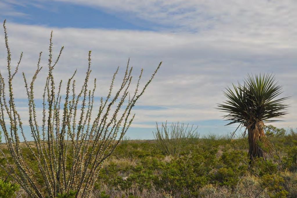
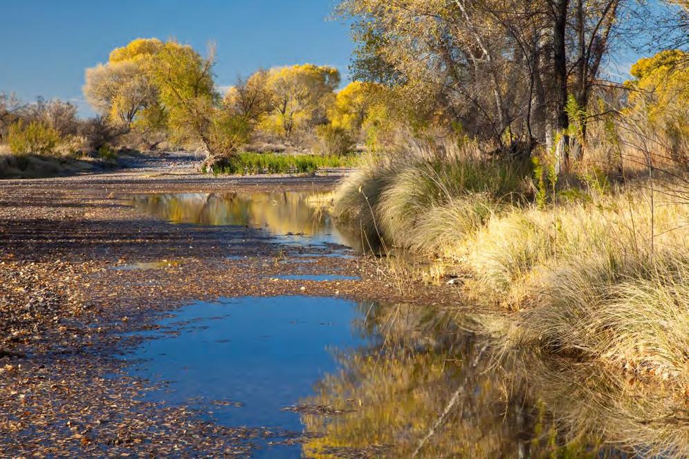
2 Kennedy Ranch 3,187 Acres Casa Piedra Road Marfa, Presidio County, Texas James King, Agent Office Location The Kennedy Ranch is located 25 miles south of Marfa, Texas off of paved Casa Piedra Road (FM169) just past the bridge over live water Alamito Creek. The ranch lies east of the Atchison and Topeka and Santa Fe Railroad or the South Orient Railroad. The pavement on Casa Piedra Road ends just past the entrance to the Kennedy Ranch where it goes for another 40 miles to the north entrance to Big Bend Ranch and to the river road east of Presidio accessing hundreds of thousands of acres of public lands and the Rio Grande River. Acreage 3,187 acres in Presidio County. Description The Kennedy Ranch is located in the Chihuahuan Desert of Texas, comprised of midelevation grasslands and scrubland of basin range topography between the Davis Mountains to the north, the Chinati Mountains to the west, and the Rio Grande River on the south. The ranch is located adjacent to large properties in the Alamito Creek Drainage and is part of the original Kennedy Ranch that had been in the same family until recently, for more than the past 60 years. This ranch is also next to Plata, an historic abandoned farming community that provided produce, cotton, and corn for the large silver operations at Shafter at the turn of the 19th century. The Alamito Creek Preserve, owned and operated by the Dixon Water Foundation, is just next door, providing opportunities for birding and hiking along its 2 ½ miles of Cottonwood-lined Alamito Creek. The buyer of this ranch will have limited access to the Preserve. The ranch is subject to a Conservation Easement with the Texas Agricultural Land Trust that focuses on restricting subdivision while allowing compatible uses like recreation, hunting, planned grazing, and limited development. Habitat The landscape is wide-open rolling grass and scrubland surrounded by rugged mountain ranges which can be seen from most places on the property. Classic Cattle County of the Old West, the Kennedy Ranch has maintained much of the environment and appearance of times past. This vast area lies in a narrow elevation range between 3,750 and 4,200 feet, allowing for mix of vegetation from the mid to lower Chihuahuan Desert such as Spanish dagger, yucca, creosote and cholla with a mix of blue grama, black grama, bear grass, and
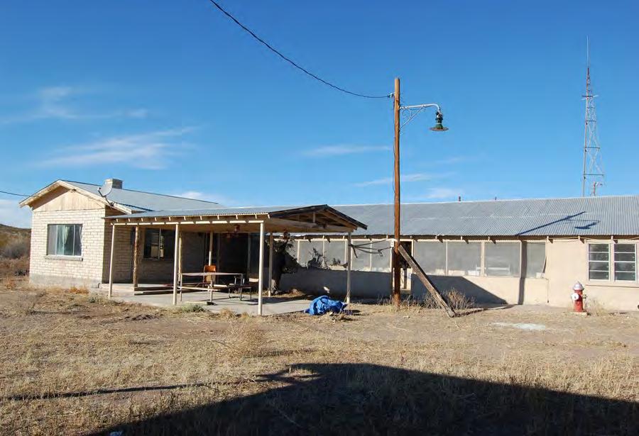
3 sideoats grama with scattered brush. Tributaries to Alamito Creek have heavier brush like mesquite, desert willow, white brush, catclaw, and some oaks and juniper. Wildlife This property is home to many species of birds, raptors, songbirds, and game birds such as Blue (Scaled) Quail, Mourning Dove and White Wing Dove, as well as larger wildlife of the desert such as Desert Mule Deer and Javelina. The brush and grasses provide excellent habitat for these game and non-game animals. This is Chihuahuan Desert hunting land at its best and a nature lover s dream. Improvements The Headquarters is located a mile off the paved Casa Piedra Road on an improved caliche ranch road and looks straight at San Jacinto Peak, a stunning western backdrop to this wide open big sky in south Presidio County. There is an adobe and brick home with lots of character in need of repair but with plenty of potential. It also has a mural painted along the porch, depicting the rich Spanish and ranching heritage of the area. Great sets of pens include a loading chute, as well as two excellent metal barns with electricity and concrete floors. At one time, the grounds around the home were well-landscaped. It s a working ranch complex that would make for a rustic yet functioning headquarters. Other improvements include two submersible wells with electricity, one windmill, an extensive road network, fair fencing, and several earthen dams for summer water. Water The Alamito Creek watershed has some of the most prolific groundwater systems in the area. There are four wells on the ranch, three being submersible pumps, and one a windmill. All the wells are less than 250 feet. Price $495 per acre or $1,577,565 Contact James King, Agent King Land & Water, LLC Office Cell James@KingLandWater.com Disclaimer This Ranch offering is subject to prior sale, change in price, or removal from the market without notice. While the information above was provided by sources deemed reliable, it is in no way guaranteed by the broker or agent.

4 KENNEDY RANCH - 3,187 AC +/- PRESIDIO COUNTY, TEXAS Van Horn Lobo C u l b e r s o n 90 Candelaria Ruidosa 10 Valentine P r e s i d i o Chinati Mountains FM 170 Date: Data Source: ESRI \ Property Ochoa Quebec Shafter Ryan Presidio Alamito Creek Preserve Dixon Water Foundation Property Boundary Kent ST 166 Pinto Canyon Rd Ê ST KING LAND & WATER Plata ST 17 Marfa \ Balmorhea J e f f D a v i s Davis Mountains State Park Ranch Rd 169 Balmorhea State Park Casa Piedra Big Bend Ranch State Park ST 17 Fort Davis Lajitas Alpine ST 118 Pecos R e e v e s 90 Terlingua Elephant Mtn. Wildlife Mgmt. Areaa Marathon 385 P e c o s ST 118 Coyanosa 385 ST 18 B r e w s t e r Black Gap Wildlife Mgmt. Area Big Bend National Park Fort Stockton Miles James King 600 North State Street PO Box 109 Fort Davis, TX P: (432) kinglandwater.com Sanderson McCamey Bakersfield Plata T e r r e l l Ranch Rd 169 ST 349 Dryden 90 ST 349 C r o c k e t t ST Sheffield Texon Miles The information contained herein was obtained from sources deemed to be reliable. Mapright Services makes no warranties or guarantees as to the completeness or accuracy thereof

 426-2024/(512) 840-1175 Creek Stream, Intermittent")


5 L AA AA L T AA T OO N OS R O CR O C K EK EE E LAND & WATER TROUGH K M M IITT O C R R EE EE K M KING KENNEDY RANCH - 3,187 AC +/PRESIDIO COUNTY, TEXAS SHED/SHACK CARPORT HOUSE BARN SHED/SHACK PAVILION Feet 169 RM U& T < TØ U Ñ C R D U N M MA N E EE E K K E ALA M IT O 0" # 6 # " = 0 6 Primary Road < & Gate = 0 6 House T U Trough % & ÑU T Ø Shed/Shack Well Windmill King Land & Water, LLC P: (432) /(512) Creek Stream, Intermittent Transmission Line Pavilion Road/Trail Water Storage Tank Ñ Ø Carport Fence " # s 0 Barn Ê Date: Data Source: TNRIS, USDA, Google < & UU T T s % & CR EE Pond/Tank Alamito Creek Preserve Dixon Water Foundation Property Boundary kinglandwater.com 0 2,000 4,000 8,000 Feet The information contained herein was obtained from sources deemed to be reliable. Mapright Services makes no warranties or guarantees as to the completeness or accuracy thereof apright.com
6 A L A KENNEDY RANCH - 3,187 AC +/- PRESIDIO COUNTY, TEXAS KING LAND & WATER M A T O N M II T O C R E E K SHED/SHACK HOUSE TROUGH CARPORT O S O C R E E K BARN PAVILION SHED/SHACK Feet RM RM UTUT &<&< D U N M A N C R E E K A L A M I I T O C R Date: Data Source: TNRIS, USDA, Google "# Barn 0 s Carport &< Gate = House 0 Pavilion 6 Shed/Shack UT Trough ÑØ &% Water Storage Tank Well Windmill E E K Fence Primary Road Road/Trail Transmission Line Creek Stream, Intermittent Pond/Tank Ê Alamito Creek Preserve Dixon Water Foundation Property Boundary &<&< &%&% UTUT UTUT 0 66 s "#"# == 00 "#"# 66 ÑØÑØ UTUT UTUT ÑØÑØ 0 2,000 4,000 8,000 Feet King Land & Water, LLC P: (432) /(512) kinglandwater.com The information contained herein was obtained from sources deemed to be reliable. Mapright Services makes no warranties or guarantees as to the completeness or accuracy thereof

7

8 Protecti11g Clie11ts. Conservi,rg the La11d.

9


10


11


12

13
Kennedy Ranch 3,187 Acres, near Marfa, Presidio County Texas
 Kennedy Ranch 3,187 Acres, near Marfa, Presidio Texas James King, Agent Office 432-426-2024 Cell 432-386-2821 James@KingLandWater.com King Land & Water LLC P.O. Box 109, 600 State Street, Fort Davis, TX
South Alamito Creek Ranch
 South Alamito Creek Ranch 1500 acres, Presidio County, Texas James King, Agent Office 432-426-2024 Cell 432-386-2821 James@KingLandWater.com King Land & Water LLC P.O. Box 109, 600 State Street, Fort Davis,
Alamito Waters Ranch 80 acres, Presidio County, Texas James King, Agent Office Cell
 Alamito Waters Ranch 80 acres, Presidio County, Texas James King, Agent Office 432-426-2024 Cell 432-386-2821 James@KingLandWater.com King Land & Water LLC P.O. Box 109, 600 State Street, Fort Davis, TX
Quebec Ranch 12,500Acres Presidio County, Texas
 Quebec Ranch 12,500Acres Presidio County, Texas James King, Agent Office 432.426.2024 Cell 432.386.2821 James@KingLandWater.com Quebec Ranch 12,500 Acres Marfa, Presidio County, Texas James King, Agent
Quebec Ranch 12,500 acres, Presidio County
 Quebec Ranch 12,500 acres, Presidio County Quebec Ranch 12,500 Acres Marfa, Presidio County, exas James King, Agent Office 432.426.2024 James@KingLandWater.com Location he Quebec Ranch is located 25 miles
Comanche Trail Ranch 48,404 Acres, Pecos County, Texas James King, Agent Office Cell
 Comanche rail Ranch 48,404 Acres, Pecos County, exas James King, Agent Office 432-426-2024 Cell 432-386-2821 James@KingLandWater.com King Land & Water LLC P.O. Box 109, 600 State Street, Fort Davis, X
Agua Fria Ranch +/- 23,482 Acres South of Alpine, Texas Adjacent to Big Bend Ranch State Park
 Agua Fria Ranch +/- 23,482 Acres South of Alpine, Texas Adjacent to Big Bend Ranch State Park James King, Agent Office 432.426.2024 Cell 432.386.2821 James@KingLandWater.com King Land & Water LLC P.O.
Alamito Creek Preserve Ranches for Sale Marfa, Presidio County, Texas
 Alamito Creek Preserve Ranches for Sale Marfa, Presidio County, Texas James King, Agent Office 432 426.2024 Cell 432 386.2821 James@KingLandWater.com Alamito Creek Preserve Various size Ranch Properties,
Aplomado Flats Ranch acres, Brewster County, Texas
 Aplomado Flats Ranch 2701.7 acres, Brewster County, Texas James King, Agent Office 432-426-2024 Cell 432-386-2821 James@KingLandWater.com King Land & Water LLC P.O. Box 109, 600 State Street, Fort Davis,
carpenter real estate presents:
 carpenter real estate presents: this is one of the best trophy class desert mule deer, aoudad sheep and bird hunting ranches in west texas. Elevations range from 4,400 feet to 5,180 feet. Ideal habitat
Randolph Ranch 12,164 Acres Brewster and Pecos Counties, Texas
 Randolph Ranch 12,164 Acres Brewster and Pecos Counties, Texas James King, Agent Office 432.426.2024 Cell 432.386.2821 James@KingLandWater.com Randolph Ranch 12,164 Acres Brewster and Pecos Counties, Texas
Blue Mountain Retreat Acres, Jeff Davis County, Texas
 Blue Mountain Retreat 29.33 Acres, Jeff Davis County, Texas Blue Mountain Retreat 29.33 acres Fort Davis, Jeff Davis County, Texas James King, Agent Office 432 426.2024 James@KingLandWater.com Location
Marfa House and Ranch Property 2,400 acres with premier residence, Marfa, Presidio County, Texas
 Marfa House and Ranch Property 2,400 acres with premier residence, Marfa, Presidio County, Texas James King, Agent Office 432 426.2024 Cell 432 386.2821 James@KingLandWater.com Marfa House and Ranch Property
The Swan House and Adobe Construction Lab Sales Presentation Presidio, Texas Big Bend Country, reachable by scenic route only.
 The Swan House and Adobe Construction Lab Sales Presentation Presidio, Texas Big Bend Country, reachable by scenic route only. 500 Acres 2,000 sq. ft. house 360º views Adjacent to Big Bend State Park Solar
Cherry County, Nebraska
 Cherry County, Nebraska Co-Listed with Maddux Landbanc Realty, LLC Offered Exclusively By: NORTH PLATTE OFFICE P.O. Box 1166 I-80 & US Hwy 83 North Platte, NE 69103 www.agriaffiliates.com (308) 534-9240
David Gold Hiking Tours
 David Gold Hiking Tours Join us for a West Texas Active Adventure Tour February 14 21, 2017 Led by David Gold and Ulrike Porat The Big Bend area of West Texas is one of the most remote, and least visited
Coyote Creek Apache County, Arizona
 Coyote Creek Apache County, Arizona Listed for sale exclusively by: Traegen Knight Headquarters West Ltd. PO BOX 1980 St. Johns, AZ 85936 Phone: (928) 524-3740, Fax: (928) 563-7004, Cell: (602) 228-3494
Changes in Texas Ecoregions
 Comment On Lesson Changes in Texas Ecoregions The state of Texas can be divided into 10 distinct areas based on unique combinations of vegetation, topography, landforms, wildlife, soil, rock, climate,
Chapter 6. Field Trip to Sandia Mountains.
 University of New Mexico Biology 310L Principles of Ecology Lab Manual Page -40 Chapter 6. Field Trip to Sandia Mountains. Outline of activities: 1. Travel to Sandia Mountains 2. Collect forest community
Old Thomasson Range, Chico, CA
 AG-LAND INVESTMENT BROKERS 275 Sale Lane, Suite 2 / P. O. Box 896 Red Bluff, CA 96080 530.529.4400 office / 530.527.5042 fax Old Thomasson Range, Chico, CA Property: Approximately 5,270 acres bordered
Natural Texas. Regions and Climates
 Natural Texas Regions and Climates Two Kinds: Physical geography Climate, vegetation, rivers, lakes, oceans, plateaus, plains, and mountain ranges Human geography Economic activities How we earn a living
Producing Chandler Walnut Orchard
 AG-LAND Investment Brokers 275 Sale Lane Red Bluff, CA 96080 530-529-4400 Fax 530-527-5042 Producing Chandler Walnut Orchard West Sacramento Avenue - Chico, CA AG-LAND INVESTMENT BROKERS 275 Sale Lane
Cripps Ranch 76+/- Acres Orchard Development Opportunity Dixon, CA. Presented By:
 Cripps Ranch 76+/- Acres Orchard Development Opportunity Dixon, CA Presented By: Cripps Ranch 76+/- Acres Orchard Development Opportunity Dixon, CA Location: This property is located at 5663 Dally Road
BUILDING AN ASSET MANAGEMENT GEODATABASE FOR RANCHING. Matt Crawford, GISP
 BUILDING AN ASSET MANAGEMENT GEODATABASE FOR RANCHING Matt Crawford, GISP Introduction East Foundation Formed in 2007 Mission Research Education Outreach Properties Six ranches ~ 215,000 acres San Antonio
Upper Owyhee Watershed Assessment
 * Owyhee Watershed Council and Scientific Ecological Services The upper Owyhee subbasin is located in parts of three states: the southeastern corner of Oregon, the southwestern corner of Idaho, and north
Objectives. Understand the different physical & human characteristics of each region
 TEXAS REGIONS Objectives Know the 4 regions of Texas Understand the different physical & human characteristics of each region Understand how physical differences affect human characteristics (way of life)
A little helpful hint.. PLEASE TAKE CORNELL NOTES AND THEN REWRITE YOUR NOTES AT HOME. YOU WILL NEED TO ORGANIZE YOUR NOTES USING EITHER MAIN IDEAS
 JOANNE HOWARD A little helpful hint.. PLEASE TAKE CORNELL NOTES AND THEN REWRITE YOUR NOTES AT HOME. YOU WILL NEED TO ORGANIZE YOUR NOTES USING EITHER MAIN IDEAS OR QUESTIONS Can you name the Regions of
Lagunitas Creek Stewardship Plan. Marin Municipal Water District
 Lagunitas Stewardship Plan Marin Municipal Water District Final June 2011 FIGURES Lagunitas Stewardship Plan Final June 2011 Legend Tomales Bay Highway 1 Major Roads Public Lands Marin Municipal Water
LANDSCAPE CHANGE IN THE SOUTHWEST: Historical changes in selected ecosystems of the southwestern United States
 LANDSCAPE CHANGE IN THE SOUTHWEST: Historical changes in selected ecosystems of the southwestern United States Robert H. Webb U.S. Geological Survey 520 N. Park Avenue Tucson, AZ 85719 rhwebb@usgs.gov
CALIFORNIA AGRICULTURAL PR OPERTIES, IN C. BOWLSBEY 320 LIBERTY ISLAND ROAD BUYER: RASSMUSSEN TRUST
 CALIFORNIA AGRICULTURAL PR OPERTIES, IN C. BOWLSBEY 320 LIBERTY ISLAND ROAD SELLER: BOWLSBEY TRUST BUYER: RASSMUSSEN TRUST LOCATION: The Bowlsbey 320 is located ten (10) miles southeast of the City of
Big Bend National Park Visitor Study
 Big Bend National Park Visitor Study The Visitor Services Project 2 OMB Approval 1024-0099 Expiration Date: 08-15-92 3 DIRECTIONS One adult in your group should complete the questionnaire. It should only
CITY OF PORTLAND, TEXAS SERVICE PLAN FOR ANNEXATION AREA
 CITY OF PORTLAND, TEXAS SERVICE PLAN FOR ANNEXATION AREA Location and Acreage Approximately 1,863 acres of land in San Patricio County, located in the ETJ northwest of the existing City Limits. Metes and
Hydraulics and Hydrology of the Rio Grande/Bravo Basin: A Bi-National View
 Hydraulics and Hydrology of the Rio Grande/Bravo Basin: A Bi-National View Daene McKinney University of Texas at Austin Javier Aparicio Instituto Mexicano de Tecnológica del Agua Project Rio Workshop,
More Sites for the LWA: South Circle
 More Sites for the LWA: South Circle John Dickel (UNM), Pat Crane (NRL), and Aaron Cohen (NRL) August 24, 2007 ABSTRACT In this memo we describe a visit to more potential sites for the LWA. We employ the
Name period date assigned date due date returned. Texas Ecoregions
 Name period date assigned date due date returned Directions: Go to the following website: https://www-k6.thinkcentral.com/epc/start.do Use the log in that is taped to the top of your laptop. If you are
Review of Riparian Function Riparian Management Riparian Monitoring
 Review of Riparian Function Riparian Management Riparian Monitoring Water Shed Water Catchment Water catching creek Water shedding creek Properly functioning riparian area Properly Functioning Riparian
Information Paper. Kansas City District. Missouri River Fish and Wildlife Mitigation Project Jim and Olivia Hare Wildlife Area, MO
 City District Information Paper River Fish and Wildlife Mitigation Project Jim and Olivia Hare Wildlife Area, MO Riverine habitat created in 2004/2005 by modifying existing river structures along the banks,
Laboratory Exercise #3 The Hydrologic Cycle and Running Water Processes
 Laboratory Exercise #3 The Hydrologic Cycle and Running Water Processes page - 1 Section A - The Hydrologic Cycle Figure 1 illustrates the hydrologic cycle which quantifies how water is cycled throughout
TSEGI WASH 50% DESIGN REPORT
 TSEGI WASH 50% DESIGN REPORT 2/28/2014 Daniel Larson, Leticia Delgado, Jessica Carnes I Table of Contents Acknowledgements... IV 1.0 Project Description... 1 1.1 Purpose... 1 Figure 1. Erosion of a Headcut...
[Leveraging & Improving Neighborhood Connections] Area E Cedar Creek
![[Leveraging & Improving Neighborhood Connections] Area E Cedar Creek](/thumbs/86/93508963.jpg "[Leveraging & Improving Neighborhood Connections] Area E Cedar Creek") Community Charrette LINC Dallas [Leveraging & Improving Neighborhood Connections] Area E Cedar Creek 06.02.12 LINC Workshop Area E Area E has the unique distinction of at-grade frontage to the Trinity
Community Charrette LINC Dallas [Leveraging & Improving Neighborhood Connections] Area E Cedar Creek 06.02.12 LINC Workshop Area E Area E has the unique distinction of at-grade frontage to the Trinity
PUBLIC UTILITY COMMISSION OF TEXAS DOCKET NO
 Application of CenterPoint Energy Houston Electric, LLC for a Certificate of Convenience and Necessity for a Proposed 138 kv Transmission Line within Harris County, Texas PUBLIC UTILITY COMMISSION OF TEXAS
CALIFORNIA AGRICULTURAL PR OPERTIES, IN C. GALE RANCH
 CALIFORNIA AGRICULTURAL PR OPERTIES, IN C. GALE RANCH LOCATION: The Ranch is located 6 Yi miles west of the City of Davis on the northwest corner of County Roads 29A and 92E in Yolo County. SIZE: 368.64
Topographic Recreational Map Of New Mexico: Detailed Travel Map By GTR Mapping
 Topographic Recreational Map Of New Mexico: Detailed Travel Map By GTR Mapping Biological Assessment for Proposed Reconstruction of New Mexico Forest Highway 12. Cuba and Jemez Recreation Opportunity Spectrum
Fall River Valley Irrigated Farmland
 AG-LAND Investment Brokers 275 Sale Lane Red Bluff, CA 96080 530-529-4400 Fax 530-527-5042 Fall River Valley Irrigated Farmland Tehama McArthur, County, California 2015 well, 16 inch casing, 150 HP, 2,000
Chittenden Road Prune Orchard Corning, California
 AG-LAND INVESTMENT BROKERS 275 Sale Lane / P. O. Box 896 Red Bluff, CA 96080 530.529.4400 office / 530.527.5042 fax Chittenden Road Prune Orchard Corning, California Property: 40.00 acres planted to producing
FOR SALE +/- 419 ACRES ¼ Mile South of Alliance Airport
 FOR SALE +/- 419 ACRES ¼ Mile South of Alliance Airport Alliance Airport Subject property +/- 419 AC Pat McDowell +1 817 334 8106 pat.mcdowell@am.jll.com JLL 201 Main Street, Suite 1440 Fort Worth, TX
Following the Civil War, many Americans and Europeans continued to move into the WEST
 1860-1900 Following the Civil War, many Americans and Europeans continued to move into the WEST as far as the eye can see millions of acres of treeless grassland. Between the Mississippi River and the
Mule Shoe Bar South Ranch
 Mule Shoe Bar South Ranch All contiguous rangeland with sub irrigated range sites consisting of 11,555 total acres Mike Lashley Owner Broker Mike s Cell: 308-530-0134 Email: mike@lashleyland.com Property
MAPS AND THEIR CLASSIFICATION
 MAPPING MAPS AND THEIR CLASSIFICATION WHAT IS A MAP? A map is representation of the Earth's surface, showing how things are related to each other by distance, direction, and size. Maps are a way of showing
Sacramento River Farmland Anderson, California
 AG-LAND INVESTMENT BROKERS 275 Sale Lane / P. O. Box 896 Red Bluff, CA 96080 530.529.4400 office / 530.527.5042 fax Sacramento River Farmland Anderson, California Property: 45 +/- acres of farmland with
Big Chino Valley Pumped Storage Project (FERC No ) Vegetation Mapping and Habitat Assessment Study Plan
 Vegetation Mapping and Habitat Assessment Study Plan") March 21, 2018 1.0 Introduction Big Chino Valley Pumped Storage LLC (BCV), a subsidiary of ITC Holdings Corp. (ITC), submitted a preliminary permit application to the Federal Energy Regulatory Commission
March 21, 2018 1.0 Introduction Big Chino Valley Pumped Storage LLC (BCV), a subsidiary of ITC Holdings Corp. (ITC), submitted a preliminary permit application to the Federal Energy Regulatory Commission
Chapter 3. Description of the Study Area. Karl Taboga, James Stafford and Paul Taucher 3-19
 Chapter 3 Description of the Study Area Karl Taboga, James Stafford and Paul Taucher 3-19 T his study examines groundwater resources that underlie the Bear River drainage basin in Wyoming as well as areas
3.3 CLIMATE, GEOLOGY, TOPOGRAPHY, AND SOILS CLIMATE GEOLOGY TOPOGRAPHY
 3.3 CLIMATE, GEOLOGY, TOPOGRAPHY, AND SOILS This section describes the climate, geology, topography, and soil resource characteristics of the Yolo Bypass Wildlife Area (Wildlife Area). Agricultural soil
Hydrologic Briefing Tropical Storm Harvey
 Hydrologic Briefing Tropical Storm Harvey 10:30 AM CDT Sunday, August 27, 2017 Prepared by: John Metz NWSCorpus www.weather.gov/corpuschristi Situation Overview Tropical Storm Harvey Harvey to remain a
1.0 PURPOSE AND FORMAT OF THE FINAL EIR
 1.0 PURPOSE AND FORMAT OF THE FINAL EIR 1.1 PROJECT OVERVIEW CEMEX (RMC Pacific Materials, dba CEMEX) operates the Bonny Doon Shale and Limestone Quarries in Santa Cruz County for the production of Portland
Name period date assigned date due date returned. Texas Ecoregions
 Name period date assigned date due date returned Directions: Go to the following website: https://www-k6.thinkcentral.com/epc/start.do Use the log in that is taped to the top of your laptop. If you are
REQUEST FOR PROPOSALS CLOSING DATE:
 Request for Proposals 110 Westlake Drive City of West Lake Hills 110 Westlake Drive REQUEST FOR PROPOSALS CLOSING DATE: Tuesday, October 23, 2018 City of West Lake Hills Request for Proposals 1 I. INTRODUCTION
 Red River Flooding June 2015 Caddo and Bossier Parishes Presented by: Flood Technical Committee Where the Rain Falls Matters I-30 versus I-20 I-20 Backwater and Tributary Floods (Localized) 2016 Flood
Vancouver Island and Coast
 Places in B.C. This handout package provides students with a brief overview of one of seven regions in B.C. These descriptions will help students audit the different types of energy (see the Energy Primers)
NORTHWEST MENARD COUNTY, TEXAS Prepared for the City of Menard
 ... NATU AAtGAS PIPELINE SURVEY NORTHWEST MENARD COUNTY, TEXAS Prepared for the City of Menard Thomas C. Kelly and Fred Valdez, Jr. Center for Archaeological Research The University of Texas at San Antonio
Field Observations and One-Dimensional Flow Modeling of Summit Creek in Mack Park, Smithfield, Utah
 Intermountain Center for River Rehabilitation and Restoration, Utah State University 31 July 2018 Field Observations and One-Dimensional Flow Modeling of Summit Creek in Mack Park, Smithfield, Utah I.
B. T. Brady, M. S. Bedinger, John Mikels, William H. Langer, and Deborah A. Mulvihill
 DEPARTMENT OF THE INTERIOR UNITED STATES GEOLOGICAL SURVEY TO ACCOMPANY WRI REPORT 83-4121-B MAP SHOWING GROUND-WATER LEVELS, SPRINGS. AND DEPTH TO GROUND WATER, BASIN AND RANGE PROVINCE, TEXAS by B. T.
Table E1. Site details for reaches selected for PHABSIM surveys in 2007
 SURVEY DATA The relationships between available trout habitat and stream flow were investigated during the 2007, 2008 and 2009 field seasons in 21 locations using the PHABSIM (Physical Habitat Simulation)
Getting to know GIS. Chapter 1. Introducing GIS. Part 1. Learning objectives
 Part Getting to know GIS Chapter Introducing GIS Learning objectives Learn the uses of geographic information systems (GIS) Learn how GIS layers work Differentiate between GIS features and surfaces Obtain
± ACRES FOR SALE
 Attaway Rd Felix Rd ±405.04 ACRES FOR SALE EXCLUSIVE LISTING FLORENCE, ARIZONA Dobson LOCATION Property Arizona is located at the southwest corner of Price Road and Sandman Road in, Arizona Crestfield
CRUM RANCH AREA MAP YOLO COUNTY, California, AC +/-
 CRUM RANCH AREA MAP YOLO COUNTY, California, 235.59 AC +/- Map data 2016 Google Imagery 2016, CAPCOG, DigitalGlobe, Texas Orthoimagery Program, U.S. Geological Survey, USDA Farm Service Agency Boundary
Esri Image & Mapping Forum 9 July 2017 Geiger-Mode for Conservation Planning & Design by USDA NRCS NGCE
 Esri Image & Mapping Forum 9 July 2017 Geiger-Mode for Conservation Planning & Design by USDA NRCS NGCE For over 75 years, the Natural Resources Conservation Service has been a pioneer in conservation,
Mule Shoe Bar Beck Ranch
 Mule Shoe Bar Beck Ranch All contiguous combination pivot irrigated and rangeland consisting of 7,908 acres Property Highlights List Price $4,927,263 Location The historic Mule Shoe Bar Ranches are located
APPENDIX E. GEOMORPHOLOGICAL MONTORING REPORT Prepared by Steve Vrooman, Keystone Restoration Ecology September 2013
 APPENDIX E GEOMORPHOLOGICAL MONTORING REPORT Prepared by Steve Vrooman, Keystone Restoration Ecology September 2 Introduction Keystone Restoration Ecology (KRE) conducted geomorphological monitoring in
V E R M E J O P A R K R A N C H
 V E R M E J O P A R K R A N C H ABOUT TED TURNER EXPEDITIONS Ted Turner Expeditions is rooted in two million acres of wild, private North American landscape acquired by Ted Turner as a pioneering investment
The last three sections of the main body of this report consist of:
 Threatened and Endangered Species Geological Hazards Floodplains Cultural Resources Hazardous Materials A Cost Analysis section that provides comparative conceptual-level costs follows the Environmental
Sacred Lands File & Native American Contacts List Request
 Sacred Lands File & Native American Contacts List Request NATIVE AMERICAN HERITAGE COMMISSION 915 Capitol Mall, RM 364 Sacramento, CA 95814 (916) 653-4082 (916) 657-5390 Fax nahc@pacbell.net Information
Arizona Game and Fish Department s Wildlife Water Catchments Project on the Tonto National Forest
 Arizona Game and Fish Department s Wildlife Water s Project on the Tonto National Forest This project is a cooperative effort between the Tonto National Forest and Arizona Game and Fish Department. The
NEEDLES S STREET LEVEE SYSTEM SAN BERNARDINO COUNTY, CALIFORNIA NLD SYSTEM ID #
 SAN BERNARDINO COUNTY, CALIFORNIA NLD SYSTEM ID # 3805030008 PERIODIC INSPECTION REPORT NO. 1 GENERALIZED EXECUTIVE SUMMARY FINAL SYSTEM RATING: MINIMALLY ACCEPTABLE FINAL RATING DATE: AUGUST 2014 PERIODIC
Arizona Recreation Map By Benchmark Maps READ ONLINE
 Arizona Recreation Map By Benchmark Maps READ ONLINE Families can come and see what the Sierra Montana Recreation Center has to offer. The center has a game room with Xbox 360s on high definition TV's,
2 Georgia: Its Heritage and Its Promise
 TERMS region, erosion, fault, elevation, Fall Line, aquifer, marsh, climate, weather, precipitation, drought, tornado, hurricane, wetland, estuary, barrier island, swamp PLACES Appalachian Mountains, Appalachian
IDAWRA: Groundwater-flow model for the Wood River Valley aquifer system, south-central Idaho February 1, 2017, 11:30-1:00
 Idaho Section of the American Water Resources Association IDAWRA: Groundwater-flow model for the Wood River Valley aquifer system, south-central Idaho A three-dimensional numerical model of groundwater
!! The Rio Grande River starts at the Rocky Mountains in Colorado. This River is 1,885 miles long!
 The Southwest Region By Taylor Noble and Kaiya Leismer Land and water The southwest region covers a lot of land but the Southwest region has lowest amount of states in any other region. In the Southwest
POPULATION TRENDS FOR TULARE PSEUDOBAHIA AND STRIPED ADOBE LILY
 POPULATION TRENDS FOR TULARE PSEUDOBAHIA AND STRIPED ADOBE LILY Kern County has more endangered, threatened and rare plant species than most states. The geography and environmental conditions in the county
Urbanczyk CV, page 1
 Kevin Urbanczyk Professor, Department of Biology, Geology, and Physical Sciences Director, Rio Grande Research Center Sul Ross State University 400 N. Harrison, Alpine, TX 79832 432-837-8110 kevinu@sulross.edu
ACTIVE SINGLE FAMILY SUBDIVISIONS CITY OF BURLESON March 2011
 ACTIVE SINGLE FAMILY SUBDIVISIONS CITY OF BURLESON March 2011 SUBDIVISION TOTAL LOTS VACANT LOTS ALSBURY ESTATES EAST - PHASE II 45 1 ALSBURY MEADOWS - PHASE II 112 1 BROAD VALLEY FARMS 31 2 CASTLE HILL
TRACT 7: ±252 Acres Irrigated Farmland Grassland
 TRACT 7: ±252 Acres Irrigated Farmland Grassland 1880 FM 2013, Friona, Texas 79035 ±252 acres of irrigated farmland and grassland. This farmland is currently being leased and farmed. The lease agreement
How Do Human Impacts and Geomorphological Responses Vary with Spatial Scale in the Streams and Rivers of the Illinois Basin?
 How Do Human Impacts and Geomorphological Responses Vary with Spatial Scale in the Streams and Rivers of the Illinois Basin? Bruce Rhoads Department of Geography University of Illinois at Urbana-Champaign
The following maps must be provided as a part of the ADA. The appropriate scale for each map should be determined at the pre application conference.
 Main Street @ Coconut Creek DRI QUESTION 9 MAPS The following maps must be provided as a part of the ADA. The appropriate scale for each map should be determined at the pre application conference. Map
Analysis of Hydraulic Impacts on the Schuylkill River
 Analysis of Hydraulic Impacts on the Schuylkill River Manayunk Sewer Basin Construction Project and the Venice Island Recreation Center Reconstruction Project Venice Island, Manayunk, Philadelphia, PA
Steve Pye LA /22/16 Final Report: Determining regional locations of reference sites based on slope and soil type. Client: Sonoma Land Trust
 Steve Pye LA 221 04/22/16 Final Report: Determining regional locations of reference sites based on slope and soil type. Client: Sonoma Land Trust Deliverables: Results and working model that determine
Laboratory Exercise #4 Geologic Surface Processes in Dry Lands
 Page - 1 Laboratory Exercise #4 Geologic Surface Processes in Dry Lands Section A Overview of Lands with Dry Climates The definition of a dry climate is tied to an understanding of the hydrologic cycle
Texas Land Survey Maps For Wise County By Gregory A. Boyd READ ONLINE
 Texas Land Survey Maps For Wise County By Gregory A. Boyd READ ONLINE Jul 06, 2015 Genealogy Family Maps Cemetery Wise County Texas Land Survey in Books, Magazines, Texas Land Survey Maps for Wise County
Changes in Texas Ecoregions Copy the questions and answers
 Changes in Texas Ecoregions Copy the questions and answers 1. What are some kinds of damage that hurricanes cause? Roads and bridges might be washed away. Trees and power lines can be knocked down. Area
MVP WMS, George Schorr
 APPROVED JURISDICTIONAL DETERMINATION FORM U.S. Army Corps of Engineers This form should be completed by following the instructions provided in Section IV of the JD Form Instructional Guidebook. SECTION
Maps of the Rush Creek Watershed
 Maps of the Watershed Yuba River Watershed South Yuba River Watershed Watershed 1 Monitoring Sites 5 Land Cover 8 Parcel Density 2 Topology & Hydrology 6 Land Use 9 Road Density 3 Public Ownership 7 Parcels
Module 10: Resources and Virginia Geology Topic 4 Content: Virginia Geology Notes
 Virginia is composed of a very diverse landscape that extends from the beaches and barrier islands all of the way to the highly elevated Appalachian Plateau. Geologists have discovered ancient shallow
Betsy Stevenson and Allison Mohrs (Skagit County Planning and Development Services) Jenny Baker, The Nature Conservancy
 Jenny Baker, The Nature Conservancy") TC Fisher Slough Final Design and Permitting Subject: Well Review Memorandum To: From: Betsy Stevenson and Allison Mohrs (Skagit County Planning and Development Services) Jenny Baker, The ature Conservancy
TC Fisher Slough Final Design and Permitting Subject: Well Review Memorandum To: From: Betsy Stevenson and Allison Mohrs (Skagit County Planning and Development Services) Jenny Baker, The ature Conservancy
Ellis County-Midlothian to Waxahachie Trail Corridor Research
 Ellis County- to Trail Corridor Research The University of Texas at Arlington Program in Landscape Architecture, School of Architecture and The Institute of Urban Studies, The School of Urban and Public
REDWOOD VALLEY SUBAREA
 Independent Science Review Panel Conceptual Model of Watershed Hydrology, Surface Water and Groundwater Interactions and Stream Ecology for the Russian River Watershed Appendices A-1 APPENDIX A A-2 REDWOOD
RANCHO de DOS PALMAS DAVIS, California, AC +/-
 RANCHO de DOS PALMAS DAVIS, California, 507.28 AC +/- Boundary Transmission Line Pond / Tank Well SCOTT STONE P: (530) 662-4094 sastone57@gmail.com 37874 County Road 28, Woodland, Ca. 95695 The information
EBIPM Curriculum. Unit Pre/Post test. Module 1 Test. Rangeland ecosystems
 Module 1 Test. Rangeland ecosystems EBIPM Curriculum Unit Pre/Post test Species Identification - Label the species pictured with the correct name. (2 points each) 1 2 1 Mark W. Skinner. USDA, NRCS. 2011.
Advanced Geologic Exploration, Inc.
 Advanced Geologic Exploration, Inc. Scientists of the Earth PO Box 1956, Chester, CA 96020 Voice: (530) 258-4228 Fax (530) 258-4339 www.advancedgeologic.com January 23, 2009 Job No. G-081201 Terri Barber,
LATITUDE. Latitude lines run to, but are measured & The 0 of latitude that circles the earth is called the?
 LATITUDE Latitude lines run to, but are measured & The 0 of latitude that circles the earth is called the? LATITUDE 0 0 Latitude lines run east to west, but are measured north & south The 0 of latitude
Weathering and Soil Formation. Chapter 10
 Weathering and Soil Formation Chapter 10 Old and New Mountains The Appalachian Mountains appear very different from the Sierra Mountains. The Appalachians are smaller, rounded, gently sloping, and covered