The Swan House and Adobe Construction Lab Sales Presentation Presidio, Texas Big Bend Country, reachable by scenic route only.
|
|
|
- Meghan Hopkins
- 5 years ago
- Views:
Transcription


1 The Swan House and Adobe Construction Lab Sales Presentation Presidio, Texas Big Bend Country, reachable by scenic route only. 500 Acres 2,000 sq. ft. house 360º views Adjacent to Big Bend State Park Solar and Wind Powered Agricultural Tax Exemption Spring-fed Well

2 Swan house/adobe lab The Swan house was built in 1998 on a mesa overlooking Terneros Creek and just a mile and a half above the Rio Grande River that divides, as well as unites, Mexico and Texas. It was constructed out of unstabilized adobe bricks by project manager Jesusita Jimenez and builder Mauro Rodriguez, plus occasional men hired to mix mortar, install scaffolding and heft mortar and bricks. Simone Swan is the designer and overseer, civil engineer David Pobst lent a paternal eye and hand, when queried. Roofs, made of smaller adobe bricks, are in the configuration of vaults and one dome, plus a flat roof serves as observation deck for stargazing and as sleeping porch above a great hall 16 feet high. The floor plan is designed in the form of an H forming two patios oriented one to the west, the other to the east. It has a public wing and a private wing with a great hall forming the link between the two parts. On the north side are two bedrooms and two bathrooms, each with a large closet. A shower outside, 10 ft away, has hot running water. The great hall which transepts the house leads to a kitchen-dining area on one side, the living room on the other. Meals with superb views can be enjoyed in either patio and on the south side of the house that is shaded by a ramada, or overhang, of ocotillo cacti from the property. Square footage is 2,000 with the outbuildings of a guestroom, domed, and two vaulted sheds, one for the solar equipment and tools, the other sheltering a large water tank. The river attracts a variety of superb birds, fish and animals at liberty. To the south stand eight majestic tiers of Mexican Sierra whose highest range, Sierra Rica, reaches 8,000 feet, visible from the swan house mesa. Eastward one sees forever to a horizon where the abrupt mountains of the Big Bend National Park rise. To the west rise the distant Mexican Sierra Mata Agua which at dawn is aflame with red, pink and orange light cast by the rising sun; the rest of the day it is pure grey shale, with vertical seams from erosion. Northward is the fringe of the Chihuahuan desert and the Chinati range over 7,700 feet high. The dirt road which runs through the property is maintained by the county, the house stands just 1.5 miles from the paved River Road, or farm road 170 east. Ceiling of domed guest house

3 The well for the property is cited in historic documents. It is only 10 ft. deep at the edge of the arroyo because it is fed by a spring, which yields about 6,000 gallons a day. A solar pump delivers water 750 feet to the house, with a loft of 125 feet. The 500 acres on which the house is built benefit from agricultural taxexemption in the category of wilderness protection. This implies providing water for animals at the well below the house in the flood plain, and bird feeders in three places. Indian tobacco plants attract and feed humming birds, and the environment below in the draw offers food and shelter for deer and coyote, javelina and birds: owls, quail, and a variety of doves, the cactus wren, the road runner, the red - tailed hawk and more. In February-March the entire desert is in bloom: yucca, creosote, bluebonnet, small unidentified purple and yellow ground cover, white daisies, yellow daisies, fragrant bi-colored mustard and much more. The Indian tobacco flowers all year. Also fragrant in the draw are the mesquite, Texas willow and seep willow blossoms. carport

4 The unpaved road that crosses the property at a good distance from the house belongs to the owner but is maintained by the county. It leads to Marfa 60 miles to the north, and to the Big Bend ranch State Park to the east. Traffic is rare: an estimated average of 6-8 vehicles a day, except when the Ranch holds an event for horse lovers and cattle rounders. Part of this property abuts to the immense Ranch. The Parks & Wildlife staff is most friendly to Swan House. Border Patrol officers have been unobtrusive and the Sheriff s staff has helped when needed. There is room for an airstrip along the north fence line. Walking trails of great variety could be bladed but Simone has mainly followed the narrow trails of animals, or the road along fences, and the arroyo for hikes during which one is totally isolated from any ambient sound except for the occasional weekly jet. An hour s walk away in the draw stand huge, ancient cottonwood trees whose roots seem to be in water. A chupadero (wetlands) there allows sheets of water to spread nearby. Simone s land ends a few hundred feet from the trees. Total annual taxes for land and structure are around $800 a year. Deed restrictions include no paved roads, no lighting, no waste disposal and indigenous plants only. One neighbor is Daniel Estrada who cultivates alfalfa along the Rio Grande to the south. As one descends the mesa on the unpaved road, the sight of his green fields presents a true oasis. A mile to the north is a 3,000 square foot private adobe house which Simone designed and built. entrance


5 Casa Piedra Road leading to the house Exterior Sunset view Exterior


6 Southern view to Mexico View to the north. Garden with yuccas and an allee of agave Domed guest house


7 Courtyard Patio with fountain Solar panels and windmill


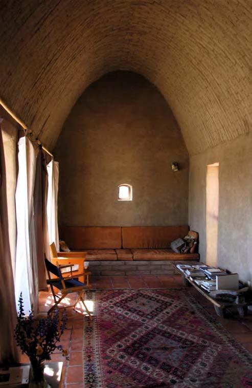
8 Bedroom with adobe bed Bedroom with adobe bed Living room with built in adobe couch The Great Hall


9 Lecture circle Jesusita Jimenez plastering vaulted ceiling Constructing a dome Building an arch Efran Rodriguez-Adobe master, Simone Swan-Owner and Stevan de la Rosa-Instructor Sealing a dome

10 Plan of Swan Compound (top faces north.)
Alamito Creek Preserve Ranches for Sale Marfa, Presidio County, Texas
 Alamito Creek Preserve Ranches for Sale Marfa, Presidio County, Texas James King, Agent Office 432 426.2024 Cell 432 386.2821 James@KingLandWater.com Alamito Creek Preserve Various size Ranch Properties,
Alamito Waters Ranch 80 acres, Presidio County, Texas James King, Agent Office Cell
 Alamito Waters Ranch 80 acres, Presidio County, Texas James King, Agent Office 432-426-2024 Cell 432-386-2821 James@KingLandWater.com King Land & Water LLC P.O. Box 109, 600 State Street, Fort Davis, TX
South Alamito Creek Ranch
 South Alamito Creek Ranch 1500 acres, Presidio County, Texas James King, Agent Office 432-426-2024 Cell 432-386-2821 James@KingLandWater.com King Land & Water LLC P.O. Box 109, 600 State Street, Fort Davis,
Kennedy Ranch 3,187 Acres, near Marfa, Presidio County Texas
 Kennedy Ranch 3,187 Acres, near Marfa, Presidio Texas James King, Agent Office 432-426-2024 Cell 432-386-2821 James@KingLandWater.com King Land & Water LLC P.O. Box 109, 600 State Street, Fort Davis, TX
Kennedy Ranch /- acres, Presidio County, Texas
 Kennedy Ranch 3187 +/- acres, Presidio County, Texas Kennedy Ranch 3,187 Acres Casa Piedra Road Marfa, Presidio County, Texas James King, Agent Office 432 426.2024 James@KingLandWater.com Location The
Agua Fria Ranch +/- 23,482 Acres South of Alpine, Texas Adjacent to Big Bend Ranch State Park
 Agua Fria Ranch +/- 23,482 Acres South of Alpine, Texas Adjacent to Big Bend Ranch State Park James King, Agent Office 432.426.2024 Cell 432.386.2821 James@KingLandWater.com King Land & Water LLC P.O.
Quebec Ranch 12,500Acres Presidio County, Texas
 Quebec Ranch 12,500Acres Presidio County, Texas James King, Agent Office 432.426.2024 Cell 432.386.2821 James@KingLandWater.com Quebec Ranch 12,500 Acres Marfa, Presidio County, Texas James King, Agent
Marfa House and Ranch Property 2,400 acres with premier residence, Marfa, Presidio County, Texas
 Marfa House and Ranch Property 2,400 acres with premier residence, Marfa, Presidio County, Texas James King, Agent Office 432 426.2024 Cell 432 386.2821 James@KingLandWater.com Marfa House and Ranch Property
carpenter real estate presents:
 carpenter real estate presents: this is one of the best trophy class desert mule deer, aoudad sheep and bird hunting ranches in west texas. Elevations range from 4,400 feet to 5,180 feet. Ideal habitat
A little helpful hint.. PLEASE TAKE CORNELL NOTES AND THEN REWRITE YOUR NOTES AT HOME. YOU WILL NEED TO ORGANIZE YOUR NOTES USING EITHER MAIN IDEAS
 JOANNE HOWARD A little helpful hint.. PLEASE TAKE CORNELL NOTES AND THEN REWRITE YOUR NOTES AT HOME. YOU WILL NEED TO ORGANIZE YOUR NOTES USING EITHER MAIN IDEAS OR QUESTIONS Can you name the Regions of
Quebec Ranch 12,500 acres, Presidio County
 Quebec Ranch 12,500 acres, Presidio County Quebec Ranch 12,500 Acres Marfa, Presidio County, exas James King, Agent Office 432.426.2024 James@KingLandWater.com Location he Quebec Ranch is located 25 miles
Coyote Creek Apache County, Arizona
 Coyote Creek Apache County, Arizona Listed for sale exclusively by: Traegen Knight Headquarters West Ltd. PO BOX 1980 St. Johns, AZ 85936 Phone: (928) 524-3740, Fax: (928) 563-7004, Cell: (602) 228-3494
Deserts. oasis. scorpion. camel. tarantula. barrel cactus. coyote. What can you see in deserts? Match. 1 Earth & Space Science
 What can you see in deserts? Match. oasis scorpion camel tarantula barrel cactus coyote 1 Earth & Space Science Look, write the words, and match. desert mammal pollen reptile 1. cold-blooded vertebrate
David Gold Hiking Tours
 David Gold Hiking Tours Join us for a West Texas Active Adventure Tour February 14 21, 2017 Led by David Gold and Ulrike Porat The Big Bend area of West Texas is one of the most remote, and least visited
V E R M E J O P A R K R A N C H
 V E R M E J O P A R K R A N C H ABOUT TED TURNER EXPEDITIONS Ted Turner Expeditions is rooted in two million acres of wild, private North American landscape acquired by Ted Turner as a pioneering investment
Comanche Trail Ranch 48,404 Acres, Pecos County, Texas James King, Agent Office Cell
 Comanche rail Ranch 48,404 Acres, Pecos County, exas James King, Agent Office 432-426-2024 Cell 432-386-2821 James@KingLandWater.com King Land & Water LLC P.O. Box 109, 600 State Street, Fort Davis, X
Learning Objectives: I can identify and interpret river flows and directions.
 Learning Objectives: I can identify and interpret river flows and directions. Bellringer Review: Check for Understanding Questions: 1 2 What Are The Key Parts Of A River s Anatomy? In your data notebooks
Objectives. Understand the different physical & human characteristics of each region
 TEXAS REGIONS Objectives Know the 4 regions of Texas Understand the different physical & human characteristics of each region Understand how physical differences affect human characteristics (way of life)
!! The Rio Grande River starts at the Rocky Mountains in Colorado. This River is 1,885 miles long!
 The Southwest Region By Taylor Noble and Kaiya Leismer Land and water The southwest region covers a lot of land but the Southwest region has lowest amount of states in any other region. In the Southwest
MAPS AND THEIR CLASSIFICATION
 MAPPING MAPS AND THEIR CLASSIFICATION WHAT IS A MAP? A map is representation of the Earth's surface, showing how things are related to each other by distance, direction, and size. Maps are a way of showing
S a c r a m e n t o S t r e e t, S a n F r a n c i s c o. M a l i n G i d d i n g s & M a x A r m o u r
 PAC I F I C H E I G H T S H i s t o r i c Q u e e n A n n e M a n s i o n 2 2 2 0 S a c r a m e n t o S t r e e t, S a n F r a n c i s c o P r e s e n t e d b y : M a l i n G i d d i n g s & M a x A r
EXPLORER S GUIDE FOR A SELF-GUIDED VISIT. Welcome to the Arizona-Sonora Desert Museum!
 EXPLORER S GUIDE FOR A SELF-GUIDED VISIT Welcome to the Arizona-Sonora Desert Museum! Instructions: Review the questions in this guide before you visit the Desert Museum. You should be able to find all
There are approximately 25,000 species of Bee in the World There are almost 4000 species of Bee in North America There are approximately 1000
 There are approximately 25,000 species of Bee in the World There are almost 4000 species of Bee in North America There are approximately 1000 different species of Bee in Texas There are only 7-9 species
Beekeeping in Urban Areas. Where to put your bees!
 Beekeeping in Urban Areas Where to put your bees! Check the laws in your area Go online Regulations such as distance from property lines Neighbors signatures Considerations Neighbors Pools Fences Dogs
Aplomado Flats Ranch acres, Brewster County, Texas
 Aplomado Flats Ranch 2701.7 acres, Brewster County, Texas James King, Agent Office 432-426-2024 Cell 432-386-2821 James@KingLandWater.com King Land & Water LLC P.O. Box 109, 600 State Street, Fort Davis,
9. Parashant Dark Sky Park Light Management Plan (LMP)
") 9. Parashant Dark Sky Park Light Management Plan (LMP) Introduction: Grand Canyon-Parashant National Monument encompasses over a million acres, including joint federal agencies, Arizona state lands, and
9. Parashant Dark Sky Park Light Management Plan (LMP) Introduction: Grand Canyon-Parashant National Monument encompasses over a million acres, including joint federal agencies, Arizona state lands, and
More Sites for the LWA: South Circle
 More Sites for the LWA: South Circle John Dickel (UNM), Pat Crane (NRL), and Aaron Cohen (NRL) August 24, 2007 ABSTRACT In this memo we describe a visit to more potential sites for the LWA. We employ the
Changes to Land 5.7B. landforms: features on the surface of Earth such as mountains, hills, dunes, oceans and rivers
 All the landforms on Earth have changed over time and continue to change. Many of the changes were caused by wind, moving water, and moving ice. Mountains have grown and shrunk. Rivers have cut away land
2. Tell which graph corresponds to person 1 in Table 1-9.2b above.
 1. An architect charges $1800 for a first draft of a three-bedroom house. If the work takes longer than 8 hours, the architect charges $105 for each additional hour. What would be the total cost for a
Severe Weather Shelters
 Severe Weather Shelters When tornadoes and other severe weather affect your area, it is incredibly important that you know where a good shelter is. In general these are some characteristics of a GOOD tornado/severe
Blue Mountain Retreat Acres, Jeff Davis County, Texas
 Blue Mountain Retreat 29.33 Acres, Jeff Davis County, Texas Blue Mountain Retreat 29.33 acres Fort Davis, Jeff Davis County, Texas James King, Agent Office 432 426.2024 James@KingLandWater.com Location
Cherry County, Nebraska
 Cherry County, Nebraska Co-Listed with Maddux Landbanc Realty, LLC Offered Exclusively By: NORTH PLATTE OFFICE P.O. Box 1166 I-80 & US Hwy 83 North Platte, NE 69103 www.agriaffiliates.com (308) 534-9240
Think about the landforms where you live. How do you think they have changed over time? How do you think they will change in the future?
 reflect All the landforms on Earth have changed over time and continue to change. Many of the changes were caused by wind, moving water, and moving ice. Mountains have grown and shrunk. Rivers have cut
LIMAVADY ROAD 1. perfectly PLACED
 LIMAVADY ROAD 1 perfectly PLACED Located just off Derry City s picturesque, tree-lined Limavady Road, and set within Ebrington Park, nestles our Ebrington Lane development. The Limavady Road area has become
Weathering/ Erosion/ Deposition in the Texas Ecoregions
 Practice Test Study these answers Weathering/ Erosion/ Deposition in the Texas Ecoregions 1. In the Texas Panhandle, physical weathering by abrasion is usually caused by wind, water and gravity 2. Two
Wyoming State Operations Center
 Wyoming State Operations Center Updated Situation Report, Bordeaux Tornado site 14: 36 hrs 8 June 2012 Wyoming Office of Homeland Security (WOHS) arrived at the incident command post at the corner of Olson
Prowtings, Chawton, Hampshire
 Prowtings, Chawton, Hampshire An important village house in the heart of this historic village Elegant Reception Hall Drawing Room Dining Room Study/Sitting Room Kitchen/Breakfast Room Utility Room Boiler
The United States & Canada. A Regional Study of Anglo America
 A Regional Study of Anglo America Landform Regions of the United States & Canada world leaders in agricultural and industrial production because of... VAST LANDS stretch from the Atlantic Ocean on the
James A Schuyler 220 Palo Alto Avenue San Francisco CA (415) September, 2004
 September, 2004") James A Schuyler 220 Palo Alto Avenue San Francisco CA 94114 (415) 242-2424 26 September, 2004 I went to Yosemite backcountry with Clark Quinn last weekend (September, 2004) for a couple of days. We did
James A Schuyler 220 Palo Alto Avenue San Francisco CA 94114 (415) 242-2424 26 September, 2004 I went to Yosemite backcountry with Clark Quinn last weekend (September, 2004) for a couple of days. We did
Contents. Reinforcement & Extension worksheets
 Contents Reinforcement & Extension worksheets Reinforcement? Unit? Look and circle. jump / run rollerblade / dance climb / jump ride a bike / dance jump / rollerblade run / ride a bike ride a bike dance
conceptdesigns C0NCEPTDESIGNSARCHITETURE.CO.NZ architecture S t a g e Gisborne Beach House
 C0NCEPTDESIGNSARCHITETURE.CO.NZ conceptdesigns architecture S t a g e 2 A Gisborne Beach House GISBORNE BEACH BRIEF HOUSE conceptdesigns architecture Beth and Chris want to design and build their forever
ORGONE INSTITUTE PHOTOGRAPHIC SLIDES
 ORGONE INSTITUTE PHOTOGRAPHIC SLIDES OROP EA LIST No. Date Subject 1 1954 Laboratory: The desert problem - Et + El = Sand 2 1954 Antibiotic Experiment - Et effect = Ded. Biotics 3 1954 Microscopy TRIP
Urban Planning Word Search Level 1
 Urban Planning Word Search Level 1 B C P U E C O S Y S T E M P A R E U O E U R B A N P L A N N E R T N S T D H E C O U N T Y G E R E R D W R E N I C I T Y C O U N C I L A A A S U G G C I L A G P R I R
Grade Five Social Studies Assessment Regions/Native Americans
 Name Grade Five Social Studies Assessment Regions/Native Americans Use the map below to answer questions 1 and 2 1. (Geo 1) For this location give the name of the city found there. 38 N, 100 W a. Scottsbluff
 T H E M A R I N A S u n n y & B r i g h t M i d - C e n t u r y H o m e 1 3 0 R e t i r o W a y, S a n F r a n c i s c o P r e s e n t e d b y : M a l i n G i d d i n g s & M a x A r m o u r 415.531.5033
Did You Ever Wonder? Landforms, C52. Slow Changes on Land, C58. Fast Changes on Land, C68
 \ - i -Vt1 t _ 9 \ "» y \R Landforms, C52 Slow Changes on Land, C58 Fast Changes on Land, C68 w -4 Did You Ever Wonder? What forces shaped these rocks? Wind and rain shaped them over thousands of years.
What is a map? Understanding your map needs
 What is a map? A map is simply a drawing or picture of a landscape or location. Maps usually show the landscape as it would be seen from above, looking directly down. As well as showing the landscape of
SAGUARO AND AGAVE SURVEY: PROPOSED SANTA RITA ROAD WATERLINE FOR THE ROSEMONT PROJECT TABLE OF CONTENTS LIST OF FIGURES
 SAGUARO AND AGAVE SURVEY: PROPOSED SANTA RITA ROAD WATERLINE FOR THE ROSEMONT PROJECT PREPARED FOR: PREPARED BY: Rosemont Copper Company WestLand Resources, Inc. DATE: February 3, 2010 PROJECT NO. 1049.14
Information Paper. Kansas City District. Missouri River Fish and Wildlife Mitigation Project Jim and Olivia Hare Wildlife Area, MO
 City District Information Paper River Fish and Wildlife Mitigation Project Jim and Olivia Hare Wildlife Area, MO Riverine habitat created in 2004/2005 by modifying existing river structures along the banks,
Following the Civil War, many Americans and Europeans continued to move into the WEST
 1860-1900 Following the Civil War, many Americans and Europeans continued to move into the WEST as far as the eye can see millions of acres of treeless grassland. Between the Mississippi River and the
225 Bush Street Suite 1700 San Francisco, CA phone fax
 225 Bush Street Suite 1700 San Francisco, CA 94104 415.896.5900 phone 415.896.0332 fax www.esassoc.com memorandum date July 29, 2009 to from subject Craig Nikitas, San Francisco Planning Department Daniel
For Creative Minds. Desert Habitat Fun Facts
 For Creative Minds The For Creative Minds educational section may be photocopied or printed from our website by the owner of this book for educational, non-commercial uses. Cross-curricular teaching activities,
Georgia Milestones Student Booklet
 4WGA Writing Georgia Milestones Student Booklet Informational Task: Desert Dwellers Grade Read the Desert Dwellers passage set. PASSAGE 1: Icon of the American West By Eric Roberts The saguaro cactus
Geology (Mellow) Hike, Santa Lucia Memorial Park February 16, I. Overview of Santa Lucia Range geology and tectonic history
 Hike, Santa Lucia Memorial Park February 16, I. Overview of Santa Lucia Range geology and tectonic history") Geology (Mellow) Hike, Santa Lucia Memorial Park February 16, 2015 I. Overview of Santa Lucia Range geology and tectonic history A. Basement Rocks 1. Salinian Block Rocks Sierra Nevada Type, continental
Geology (Mellow) Hike, Santa Lucia Memorial Park February 16, 2015 I. Overview of Santa Lucia Range geology and tectonic history A. Basement Rocks 1. Salinian Block Rocks Sierra Nevada Type, continental
Changes in Texas Ecoregions Copy the questions and answers
 Changes in Texas Ecoregions Copy the questions and answers 1. What are some kinds of damage that hurricanes cause? Roads and bridges might be washed away. Trees and power lines can be knocked down. Area
T r e n t H i l l E x e c u t i v e H o m e
 1 P r e s e n t s T r e n t H i l l E x e c u t i v e H o m e H o m e o f a T o r o n t o b a s e d P r o v i n c i a l S e n i o r E x e c u t i v e P r i v a t e - ~ 5 0 0 S e t b a c k o n 1 0 2 A c
Passwords. Social Studies Vocabulary. Texas: Grade 7
 Passwords Social Studies Vocabulary Texas: Grade 7 To the Student What is federalism? How are independence and interdependence different? What does an anthropologist do? Passwords: Social Studies Vocabulary
Changes in Texas Ecoregions
 Comment On Lesson Changes in Texas Ecoregions The state of Texas can be divided into 10 distinct areas based on unique combinations of vegetation, topography, landforms, wildlife, soil, rock, climate,
5 th Grade Ecosystems Mini Assessment Name # Date. Name # Date
 An ecosystem is a community of organisms and their interaction with their environment. (abiotic, biotic, niche, habitat, population, community)- 1. Which effect does a decrease in sunlight have on a pond
One of the most important and historic houses in Regent s Park.
 t h e d o r i c v i l l a 1 9 Y o r k t e r r a c e e a s t, l o n d o n n w 1 t h e d o r i c v i l l a t h e d o r i c v i l l a 1 9 Y o r k t e r r a c e e a s T, l o n d o n n w 1 One of the most
POPULATION TRENDS FOR TULARE PSEUDOBAHIA AND STRIPED ADOBE LILY
 POPULATION TRENDS FOR TULARE PSEUDOBAHIA AND STRIPED ADOBE LILY Kern County has more endangered, threatened and rare plant species than most states. The geography and environmental conditions in the county
APPLICATION TO AMEND THE FUTURE LAND USE MAP (FLUM) SMALL SCALE
 SMALL SCALE") DEPARTMENT OF DEVELOPMENT & PLANNING 825 Ohio Avenue - Lynn Haven, FL 32444 (850) 265-2961 - (850) 265-3478 APPLICATION TO AMEND THE FUTURE LAND USE MAP (FLUM) SMALL SCALE Deadline to submit is 30 days
DEPARTMENT OF DEVELOPMENT & PLANNING 825 Ohio Avenue - Lynn Haven, FL 32444 (850) 265-2961 - (850) 265-3478 APPLICATION TO AMEND THE FUTURE LAND USE MAP (FLUM) SMALL SCALE Deadline to submit is 30 days
Fall River Valley Irrigated Farmland
 AG-LAND Investment Brokers 275 Sale Lane Red Bluff, CA 96080 530-529-4400 Fax 530-527-5042 Fall River Valley Irrigated Farmland Tehama McArthur, County, California 2015 well, 16 inch casing, 150 HP, 2,000
Answers for Chapter 5 Masters
 Answers for Chapter 5 Masters Scaffolding Answers Scaffolding for Getting Started Activity p. 53 B. By counting the squares found in each shape. The area of the green rectangle is 10 cm 2. C. The area
Jordan Harrison, Planner III, San Francisco Recreation and Park Department
 Date November 18, 2015 To: Through: From: Subject: Recreation and Park Commission Philip A. Ginsburg, General Manager Dawn Kamalanathan, Director, Capital & Planning Division Jordan Harrison, Planner III,
Erosion Information Paper Eagle City and Eagle Village, Alaska Current as of January 21, 2008
 U.S. Army Corps of Engineers ALASKA BASELINE EROSION ASSESSMENT Erosion Information Paper Eagle City and Eagle Village, Alaska Current as of January 21, 2008 Community Information The City of Eagle, population
Natural Texas. Regions and Climates
 Natural Texas Regions and Climates Two Kinds: Physical geography Climate, vegetation, rivers, lakes, oceans, plateaus, plains, and mountain ranges Human geography Economic activities How we earn a living
Most people used to live like this
 Urbanization Most people used to live like this Increasingly people live like this. For the first time in history, there are now more urban residents than rural residents. Land Cover & Land Use Land cover
Name period date assigned date due date returned. Texas Ecoregions
 Name period date assigned date due date returned Directions: Go to the following website: https://www-k6.thinkcentral.com/epc/start.do Use the log in that is taped to the top of your laptop. If you are
A First Look at Sites for the LWA
 A First Look at Sites for the LWA Greg Taylor (UNM), Pat Crane (NRL), Frazer Owen (NRAO), John Dickel (UNM) and Willie Lucero (SLO) ABSTRACT In this memo we describe the first visit to potential sites
Belen: 7:56 am Mid-Valley: 10:09 am Mid-Valley: 10:14 am Belen: 11:34 am Airtime: 3.5 hrs Total PIC Time: Total Logged Time: 1565.
 Tuesday, May 2, 2017 Cobra flight #582, PIC #595, 3 landings Amber Hills, Caldron of Hell, Valley of the Horses, Caldron, Puerco Elk, Belen, Rio Grande, Mid-Valley, Manzano Mountain Ridge Run Belen: 7:56
Listening. The Air. Did you know? Did you know?
 Listening 1. Find a place to sit. 2. Close your eyes and listen carefully to all the sounds you can hear. Cup your hands around your ears and turn your head to help you listen in particular directions.
Unit b 2 c 3 a. 2 pasture. 3 Students own answers. 4 sheep. 5 2 grass 3 water 4 milk. Lesson d 3 e 4 a 5 c. 3 water light shelter food
 Unit 1 1 hammer 3 screwdriver 4 scissors 5 nails Students own answers 3 a hammer some nails a screwdriver 4 some nails a screwdriver 1 no 3 yes 4 no 5 yes a 3 d 4 b 3 is a scientist 3 are scientists 1
Trip Generation Study: A 7-Eleven Gas Station with a Convenience Store Land Use Code: 945
 Trip Generation Study: A 7-Eleven Gas Station with a Convenience Store Land Use Code: 945 Introduction The Brigham Young University Institute of Transportation Engineers student chapter (BYU ITE) completed
Unit b 2 a 3 b. 2 1 b 2 c 3 a. Lesson b 2 a 3 a. 2 solve; Students own drawings. Lesson 2. 1 problem, idea.
 Unit question answer question answer a b Lesson c a b d c a b Lesson Students should tick all five boxes. green hand lens ruler balance safety goggles ruler safety goggles balance hand lens different alike
Naturally. Westport... Wet and Wild...
 Westport... Wet and Wild... Naturally A revitalization concept for the City of Westport and Port of Grays Harbor presented by FOGH (Friends of Grays Harbor), Wildlife Forever of Grays Harbor and other
Hickory Hills Park: Invasive Species Management Plan Prepared by Colton Johnson, Animal Ecology, Iowa State University.
 Hickory Hills Park: Invasive Species Management Plan Prepared by Colton Johnson, Animal Ecology, Iowa State University Summer 2011 Above: Hickory Hills Park Left: Garlic Mustard Right: Autumn Olive 1 Record
How Desert Plants Survive
 How Desert Plants Survive As you can imagine, the plants the producers in our Southwestern desert basins live in one of the most stressful environments in the United States. They face scorching hot air
Written by Vowery Dodd Carlile and Traci Burnett Illustrated by Karen Birchak
 Written by Vowery Dodd Carlile and Traci Burnett Illustrated by Karen Birchak Table of Contents INTRODUCTION...5 TO THE TEACHER...6 STORIES ABOUT TEXAS: Background, Vocabulary Activities, Discussion Questions,
DOWNLOAD OR READ : PLAINS AND THE PEOPLE THE PDF EBOOK EPUB MOBI
 DOWNLOAD OR READ : PLAINS AND THE PEOPLE THE PDF EBOOK EPUB MOBI Page 1 Page 2 plains and the people the plains and the people pdf plains and the people the Plains Indians, Interior Plains Indians or Indigenous
Geography and the Early Settlement of China
 Geography and the Early Settlement of I N T E R A C T I V E S T U D E N T N O T E B O O K How did geography affect life in ancient? P R E V I E W Physical Features 1. Circle the physical features that
Stone Cottage, Farnham Lane, Haslemere Guide Price 750,000
 Stone Cottage, Farnham Lane, Haslemere Guide Price 750,000 Stone Cottage FARNHAM LANE HASLEMERE SURREY GU27 1HG GUIDE PRICE 750,000 AN ATTRACTIVE PART TILE HUNG STONE COTTAGE WITH UNDOUBTED POTENTIAL OCCUPYING
BISTI / DE-NA-ZIN WILDERNESS
 BISTI / DE-NA-ZIN WILDERNESS Activities: Facilities: Season / Hours: Description: Hiking and photography. No electrical hookups, water, or restrooms are available. Open year-round. The Bisti/De-Na-Zin
Activity 3.2: Effigy Mounds
 3 Wisconsin s First People : Effigy Mounds Teacher Materials Background Information to Share Most effigy mound sites are found in Wisconsin, and most are within the southern half of the state. A few sites
Old Thomasson Range, Chico, CA
 AG-LAND INVESTMENT BROKERS 275 Sale Lane, Suite 2 / P. O. Box 896 Red Bluff, CA 96080 530.529.4400 office / 530.527.5042 fax Old Thomasson Range, Chico, CA Property: Approximately 5,270 acres bordered
Handsome Traditional East Wilmette Home
 p 847.446.9600 T h e h u d s o n c o m p a n y 851 spruce street, Winnetka, Illinois 60093 6 0 6 L a k e A v e n u e Handsome Traditional East Wilmette Home Listing agent Contact mary bradbury and julie
annex? 2 annex? 1 3F? G? H? ?? 0? annex 57
 Numbers of flowering Frasera speciosa plants in East River Valley meadows near the Rocky Mount annual count by David Inouye. Metadata at bottom of file, last updated December 2011 Year Site # 1979 1980
LANDSCAPE CHANGE IN THE SOUTHWEST: Historical changes in selected ecosystems of the southwestern United States
 LANDSCAPE CHANGE IN THE SOUTHWEST: Historical changes in selected ecosystems of the southwestern United States Robert H. Webb U.S. Geological Survey 520 N. Park Avenue Tucson, AZ 85719 rhwebb@usgs.gov
Sacramento River Farmland Anderson, California
 AG-LAND INVESTMENT BROKERS 275 Sale Lane / P. O. Box 896 Red Bluff, CA 96080 530.529.4400 office / 530.527.5042 fax Sacramento River Farmland Anderson, California Property: 45 +/- acres of farmland with
ST. DAVID S COURT DUBLIN 5
 ST. DAVID S COURT DUBLIN 5 ST. DAVID S COURT DUBLIN 5 St. David s Court is a modern development of four and five-bedroom family homes nestled in a quiet suburban setting located off the Malahide Road.
SOLUT TO AUGUST 25 T SPREAD 7 AUGUST 20 TH
 MANITOBA METIS FEDER ATION MATRIX SOLUT IONS INC. PARTNERSHIP INDIGENOUS CONSTRUCTION MONITORING WEEKLY REPORT SPREAD 7 AUGUST 20 TH TO AUGUST 25 T T H 1 1. PURPOSE OF THIS REPORT The report is a weekly
Geography Class 6 Chapters 3 and
 CHAPTER 3 MOTIONS OF THE EARTH The Earth is always travelling in Space. That makes each person on Earth, a Space Traveller. No one feels the movement of the Earth because humans are too tiny when compared
North America ATLANTIC OCEAN PACIFIC OCEAN. The First Americans. Labrador Sea. Caribbean Sea. USI_ISN_U01_01.eps. Second Proof TCI19 65.
 G e o g r a p h y C h a l l e n g e North America 70 N 180 N 60 170 W 30 W 160 W 40 W Labrador Sea 150 W 50 N 50 W Hud s on B ay 140 W 40 N 60 W ATLANTIC OCEAN 30 N PACIFIC OCEAN Gulf of Mexico 20 N 130
Name period date assigned date due date returned. Texas Ecoregions
 Name period date assigned date due date returned Directions: Go to the following website: https://www-k6.thinkcentral.com/epc/start.do Use the log in that is taped to the top of your laptop. If you are
STAAR Science Tutorial 40 TEK 8.9C: Topographic Maps & Erosional Landforms
 Name: Teacher: Pd. Date: STAAR Science Tutorial 40 TEK 8.9C: Topographic Maps & Erosional Landforms TEK 8.9C: Interpret topographic maps and satellite views to identify land and erosional features and
Project 2. Introduction: 10/23/2016. Josh Rodriguez and Becca Behrens
 Project 2 Josh Rodriguez and Becca Behrens Introduction: Section I of the site Dry, hot Arizona climate Linen supply and cleaning facility Occupied 4am-10pm with two shifts of employees PHOENIX, ARIZONA
For Creative Minds. Grassland Habitat
 For Creative Minds The For Creative Minds educational section may be photocopied or printed from our website by the owner of this book for educational, non-commercial uses. Cross-curricular teaching activities,
MANITOBA METIS FEDERATION MATRIX SOLUTIONS INC. PARTNERSHIP INDIGENOUS CONSTRUCTION MONITORING
 MANITOBA METIS FEDERATION MATRIX SOLUTIONS INC. PARTNERSHIP INDIGENOUS CONSTRUCTION MONITORING WEEKLY REPORT SPREAD 7 AUGUST 27 TH TO SEPTEMBER 1 ST 1 Matrix Solutions Inc. 1. PURPOSE OF THIS REPORT The
1. Identify the Earth motion that provides the basis for our system of local time and time zones.
 Base your answers to questions 1 through 4 on the map below and on your knowledge of Earth science. The map shows the four time zones and some latitude and longitude lines across the continental United
4thscience_lifescience (4thscience_lifescience) 4. Which of the following would probably cause the MOST harm to a pond or stream?
 4. Which of the following would probably cause the MOST harm to a pond or stream?") Name: Date: 1. Whitetail deer live on the Cumberland Island National Seashore. What would make the deer population on the island smaller? A. people moving away from the island B. planting new trees in
Name: Date: 1. Whitetail deer live on the Cumberland Island National Seashore. What would make the deer population on the island smaller? A. people moving away from the island B. planting new trees in