Quebec Ranch 12,500Acres Presidio County, Texas
|
|
|
- Christiana Neal
- 5 years ago
- Views:
Transcription


1 Quebec Ranch 12,500Acres Presidio County, Texas James King, Agent Office Cell
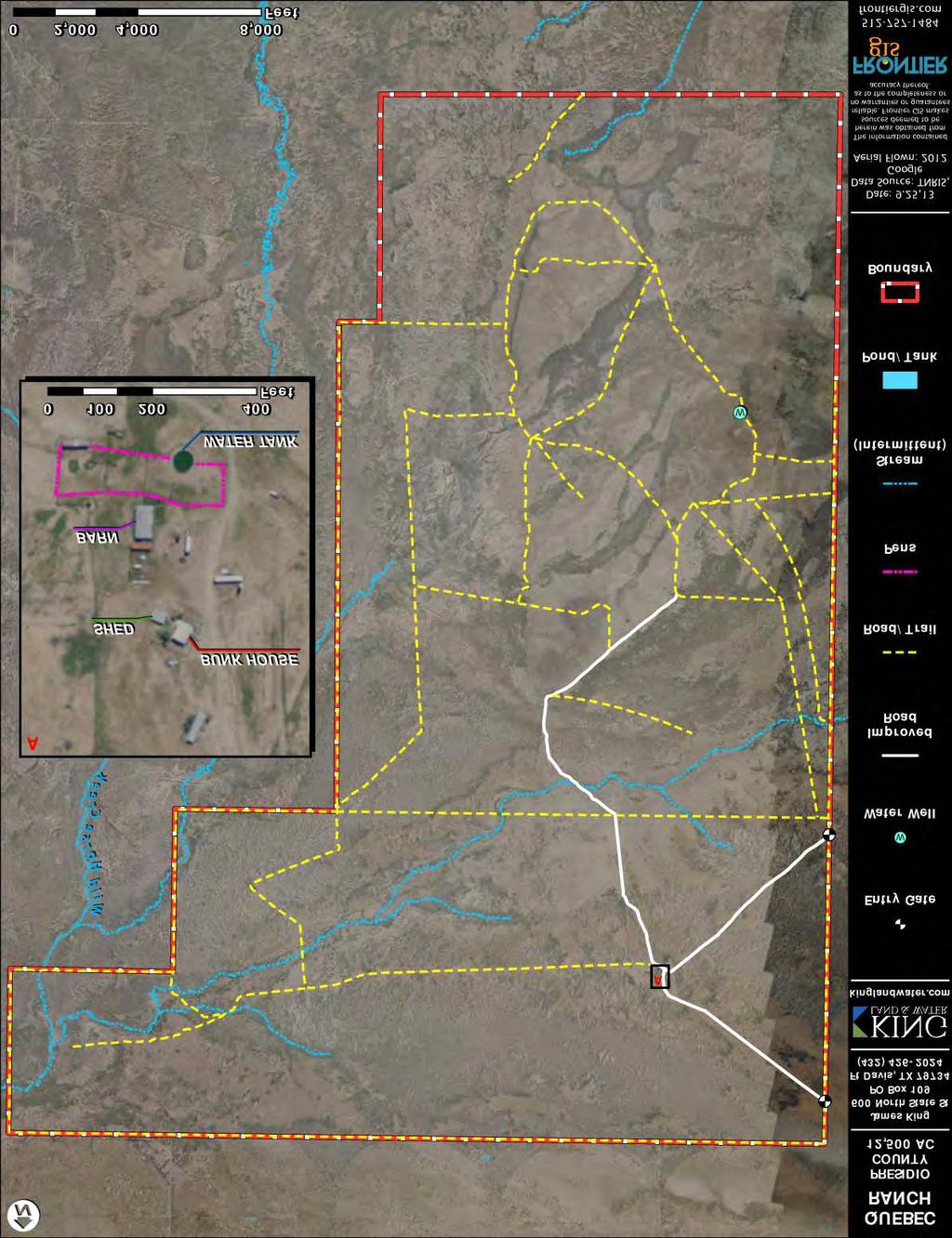
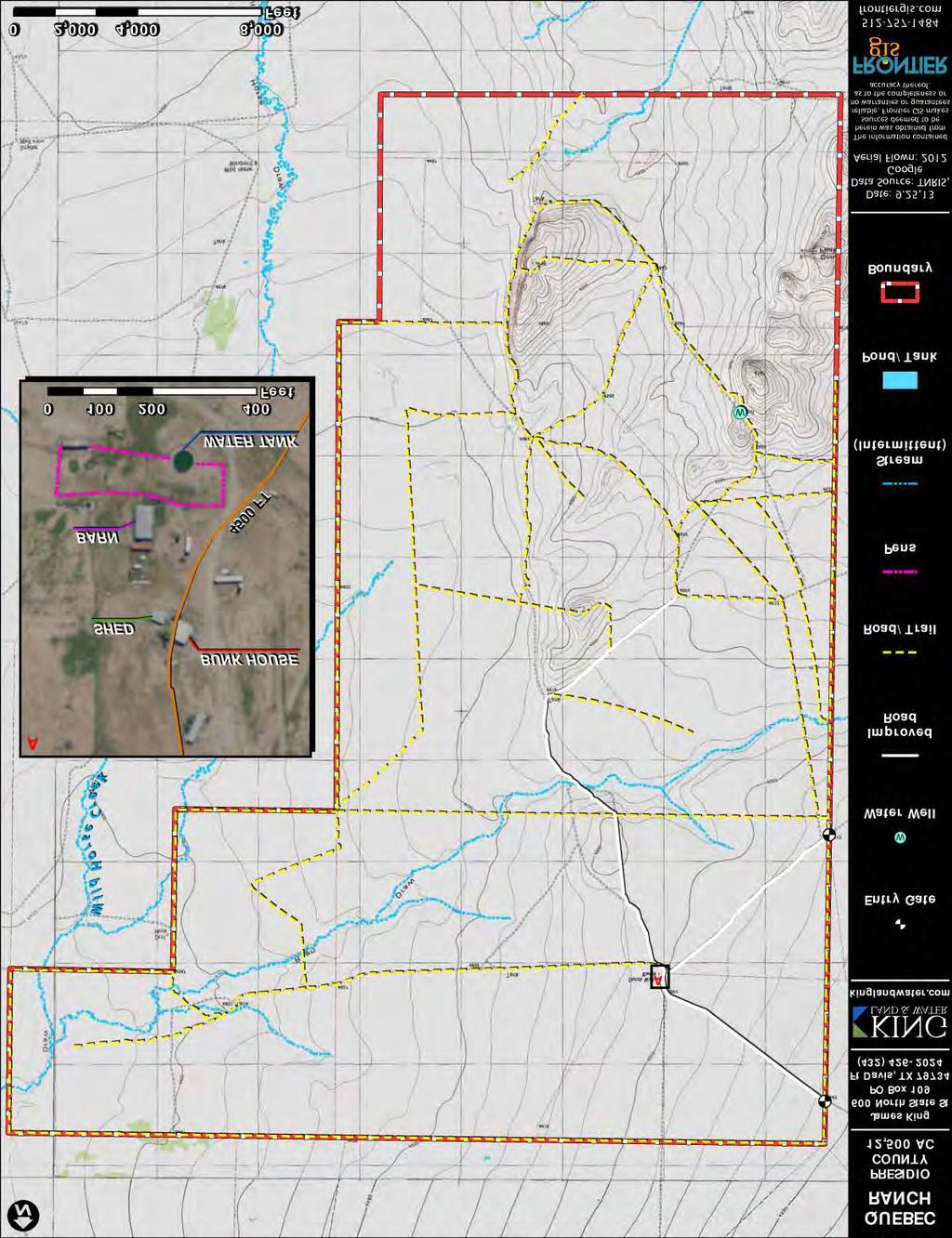
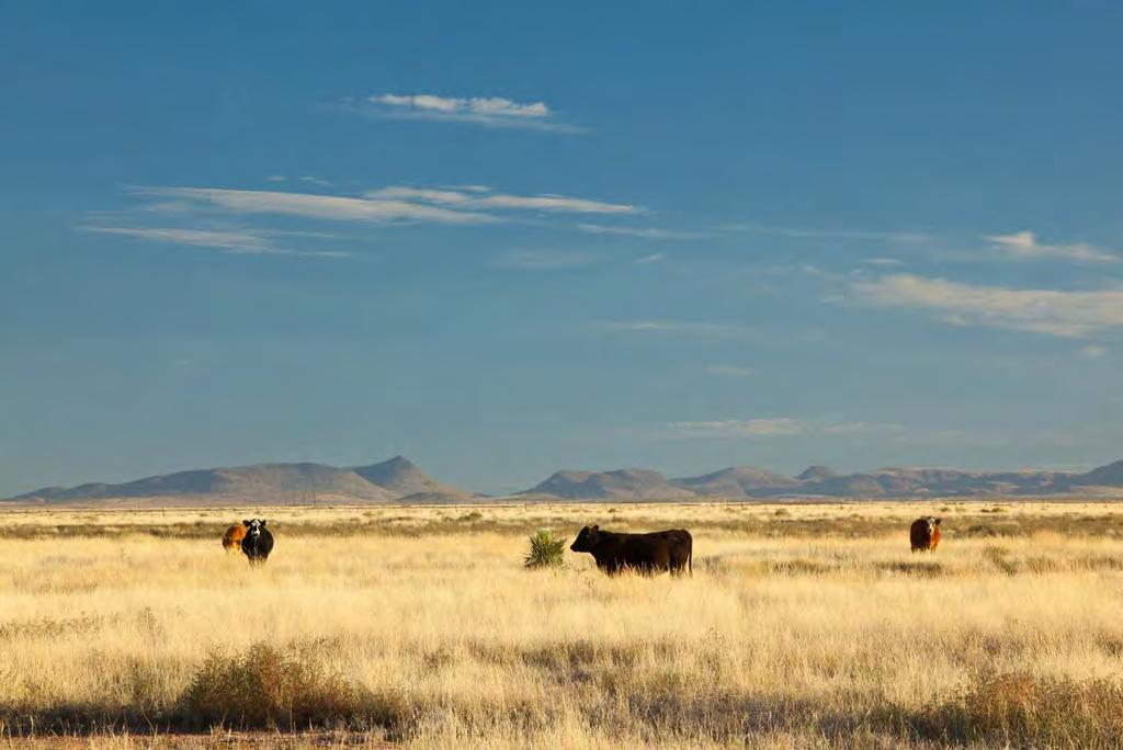
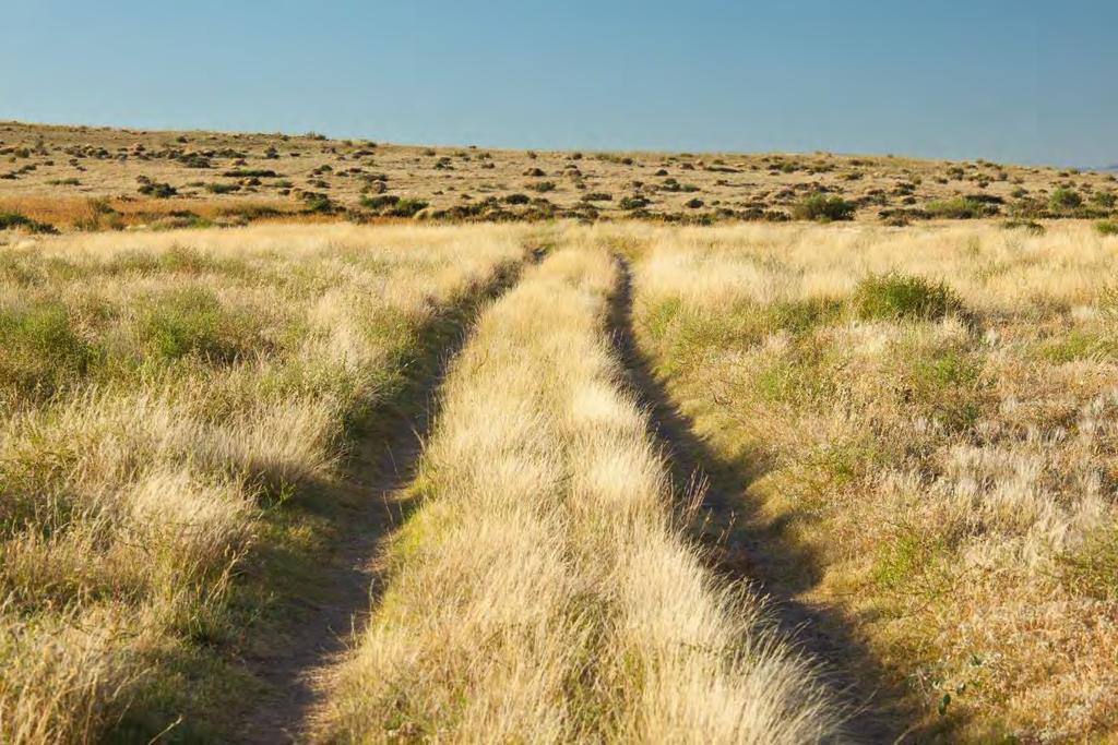
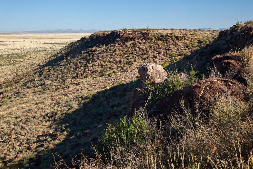
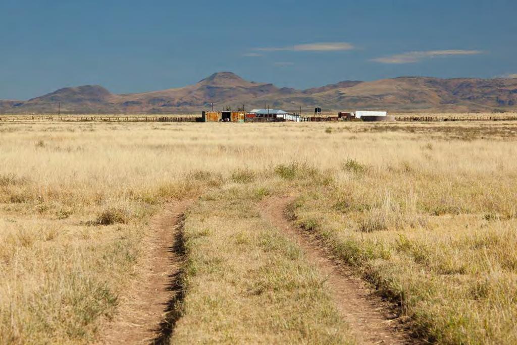
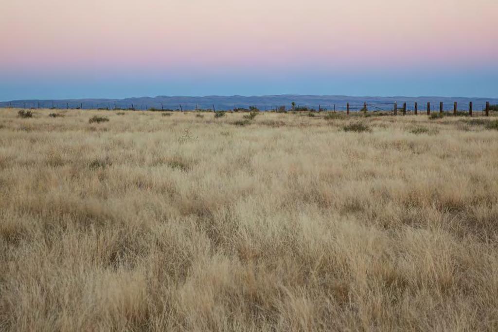
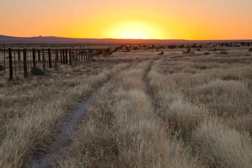
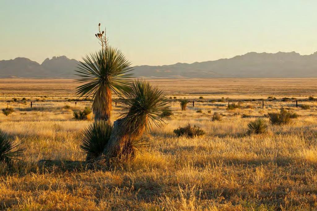
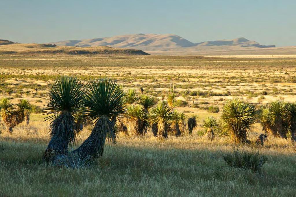
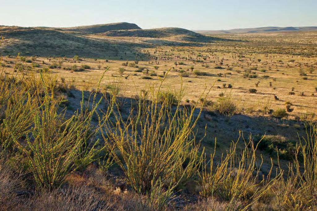
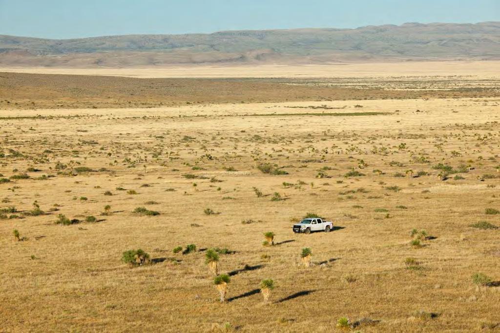
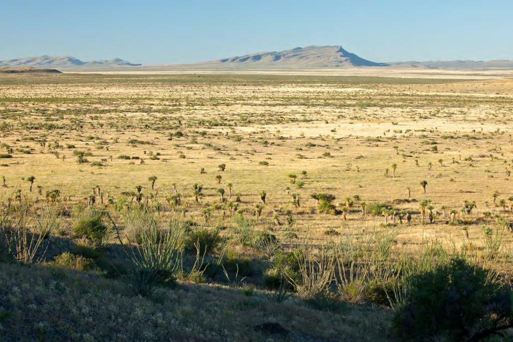
2 Quebec Ranch 12,500 Acres Marfa, Presidio County, Texas James King, Agent Office Location The Quebec Ranch is located 25 miles west of Marfa, Texas, south of State Highway 90 near the 505 Valentine cutoff to the Davis Mountains. This ranch is equally accessible to Ft. Davis and Marfa. Acreage 12,500 acres in Presidio County. Description The Quebec Ranch is Texas cow country at its finest and represents some of the best Yucca Grasslands in the United States. It is part of the Marfa Plateau, a mile-high desert grassland of basin range topography between the Davis Mountains to the north and the Chinati/Sierra Viejas Mountains and Rio Grande River on the south and southwest. The views are stunning and the ranch overlooks the landscapes of the Davis Mountains, Chinati Mountains, Sierra Viejas Mountains, Capote Mountain and the great expanse of grasslands in between. Quebec Ranch is a working cattle ranch which has been well managed by the same family for over five and a half decades. The northern portion of the ranch is wide open gramma and tobosa country where the headquarters can be seen for miles near the northern entrance. Ryan Draw, a tributary of Wild Horse Draw, meanders through this wide open grassland portion of the ranch creating a collection point for grassland runoff during the summer monsoons capturing water into several large dirt tanks. As you move south and up slope suddenly you encounter lush blue and sideoats gramma meadows with scattered forests of Yucca up to the high rocky hills on the ranch that add to the diversity of this amazing place. The highest peak, Dear Peak, with its surrounding slopes and adjacent hills, creates the topography that many ranches in the Marfa Grasslands lack. The hills, the rolling grasslands, and the wide open pastures bring together the unique elements of the far west Texas region. Habitat The landscape varies from wide-open flats to rolling grassland to a series of high hills surrounded by rugged, blue mountain ranges which can be seen from most places throughout the property. Classic Cattle Country of the Old West, the Marfa Plateau has maintained much of the environment and appearance of times past. This vast ranch lies in an elevation range between 4,375 and 4,775 feet, allowing for a mix of vegetation from the mid-high Chihuahuan Desert such as Spanish dagger, yucca, sotol, and cholla with a dominant grassland of blue grama, sideoats grama, black grama, tobosa, bear grass, and cane bluestem with areas of scattered mesquite brush. Ryan Flat noted on the
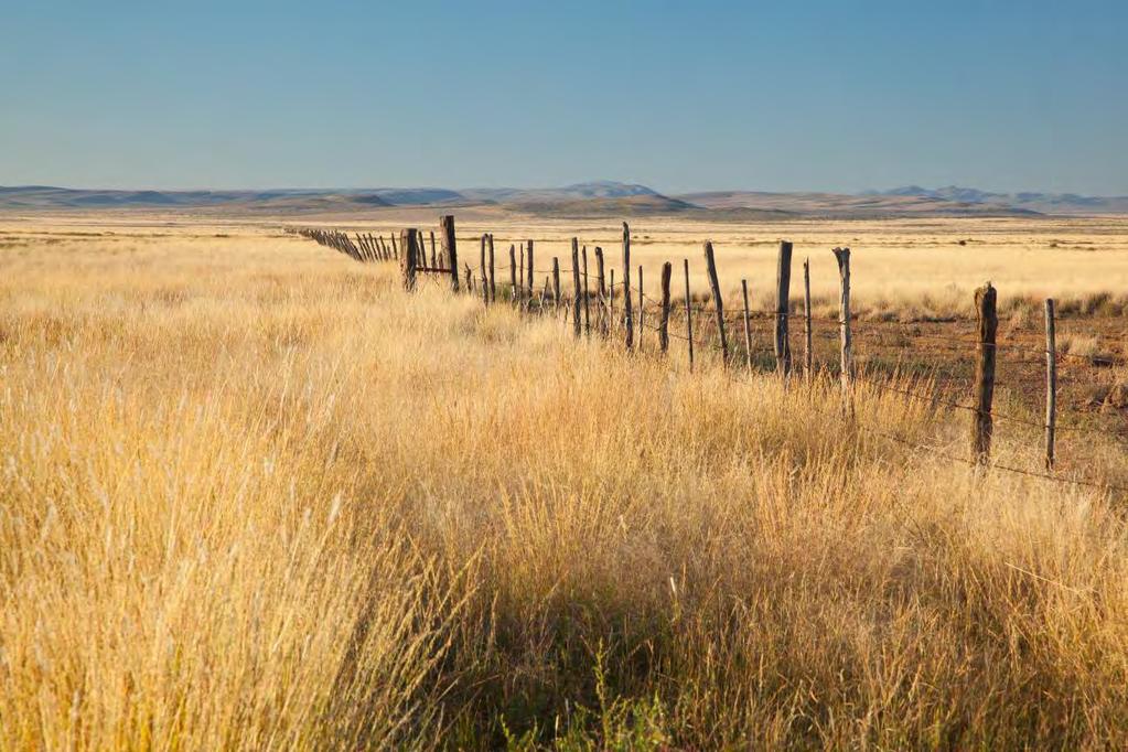
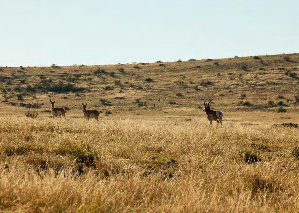
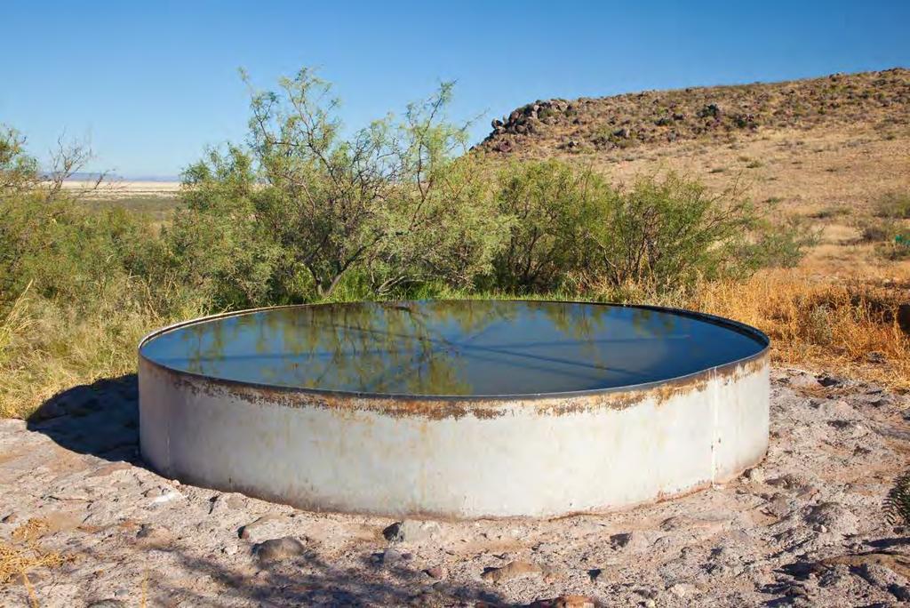
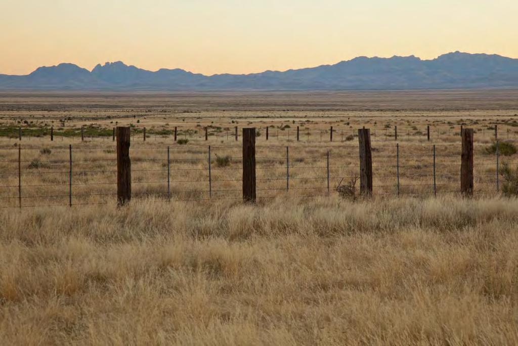
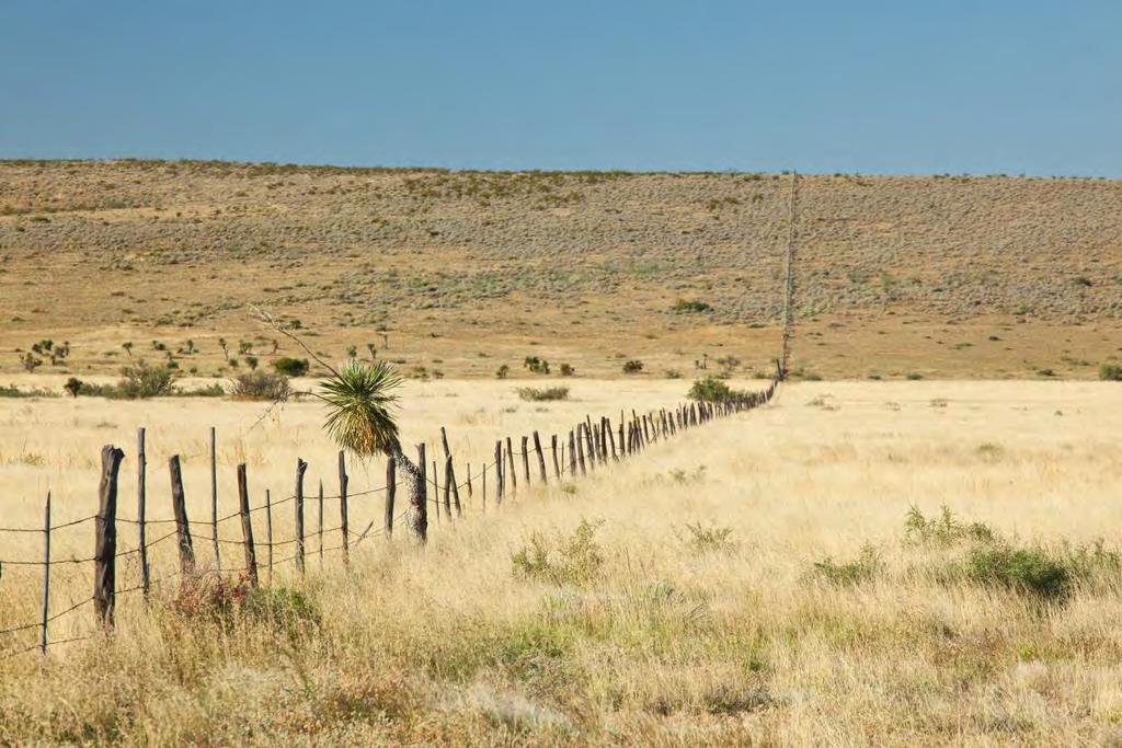
3 Topo map is a broad open grassland on the ranch and is a mix of grama grasses and expansive tabosa flats. The high hills have shoulders of Yucca Grasslands and rock outcrops on the western faces. The west side of the ranch has a mesquite brushland that is some of the best deer and quail habitat. Wildlife This property, as part of the Marfa Plateau, is home to many species of birds, raptors, songbirds, and upland game birds including Mourning Dove and Blue (Scaled) Quail as well as larger wildlife of the open prairie such as Pronghorn Antelope, and Desert Mule Deer. The grasses and brush provide excellent habitat for these game and non-game animals. This is Chihuahuan Desert Grasslands at its best and a bird hunters dream. Improvements The Headquarters is an older frame house and outbuildings that is ready for the next owner to build what they need under the distant backdrop of Mt. Livermore and Sawtooth Mountain. Fencing is in good working order as this is an operating ranch. Stocking rates are based on forage availability from annual rainfall which in an average year might be 15 AUY per section. Water The Marfa plateau has excellent groundwater known as the West Texas Bolsons and the Ryan Aquifer segment provides an abundance of groundwater for livestock and wildlife. The ranch has 4 wells with a well designed pipeline and water storage/trough system that distributes water throughout the ranch. Water is stored at several steel tanks located on elevated sites in the hills providing easy gravity flow to numerous water troughs. There are also several large dirt tanks scattered throughout the ranch that with summer rains provides additional water and habitat. Price Reduction $9,375,000 or $750 per acre Contact James King, Agent King Land & Water, LLC Office Cell James@KingLandWater.com Disclaimer This Ranch offering is subject to prior sale, change in price, or removal from the market without notice. While the information above was provided by sources deemed reliable, it is in no way guaranteed by the broker or agent.


4 PRESIDIO COUNTY, TX - QUEBEC RANCH 12,500 AC James King PO Box State Street Fort Davis, TX Tel: (432) E l P a s o El Paso Socorro San Elizario ST 54 H u d s p e t h 20 Quebec 90 Van Horn Candelaria C u l b e r s o n Lobo 90 Ruidosa Quebec!^ P r e s i d i o Indio Ochoa ST 118 J e f f D a v i s ST 166 Ryan 67 Shafter Presidio ST 17 Plata 285 ST 17 ST 118 Marfa Nopal Redford R e e v e s Fort Davis Casa Piedra L o v i n g ST 118 W i n k l e r ST ST 302 ST 18 C r a n e ST ST 17 ST 349 Alpine Pecos P e c o s W a r d Marathon Belding Chancellor B r e w s t e r West Odessa Odessa M i d l a n d E c t o r 20 ST 349 Fort Stockton Longfellow Sanderson KING LAND & WATER Midland U p t o n ST 158 ST 349 T e r r e l l Dryden 90 ST 137 C r o c k e t t 190 Sheffield Pumpville Mile s Date: Sept. 25, 2013 Legend Data Source: ESRI Legend Legend I!^ Location Boundary Terlingua Lajitas Study Butte-Terlingua Big Bend National Park Mile s The information contained herein was obtained from sources deemed to be reliable. Frontier GIS makes no warranties or guarantees as to the completeness or accuracy thereof
5
6
7
8
9
10
11
12
13
14
Quebec Ranch 12,500 acres, Presidio County
 Quebec Ranch 12,500 acres, Presidio County Quebec Ranch 12,500 Acres Marfa, Presidio County, exas James King, Agent Office 432.426.2024 James@KingLandWater.com Location he Quebec Ranch is located 25 miles
Alamito Waters Ranch 80 acres, Presidio County, Texas James King, Agent Office Cell
 Alamito Waters Ranch 80 acres, Presidio County, Texas James King, Agent Office 432-426-2024 Cell 432-386-2821 James@KingLandWater.com King Land & Water LLC P.O. Box 109, 600 State Street, Fort Davis, TX
South Alamito Creek Ranch
 South Alamito Creek Ranch 1500 acres, Presidio County, Texas James King, Agent Office 432-426-2024 Cell 432-386-2821 James@KingLandWater.com King Land & Water LLC P.O. Box 109, 600 State Street, Fort Davis,
Kennedy Ranch 3,187 Acres, near Marfa, Presidio County Texas
 Kennedy Ranch 3,187 Acres, near Marfa, Presidio Texas James King, Agent Office 432-426-2024 Cell 432-386-2821 James@KingLandWater.com King Land & Water LLC P.O. Box 109, 600 State Street, Fort Davis, TX
Agua Fria Ranch +/- 23,482 Acres South of Alpine, Texas Adjacent to Big Bend Ranch State Park
 Agua Fria Ranch +/- 23,482 Acres South of Alpine, Texas Adjacent to Big Bend Ranch State Park James King, Agent Office 432.426.2024 Cell 432.386.2821 James@KingLandWater.com King Land & Water LLC P.O.
Kennedy Ranch /- acres, Presidio County, Texas
 Kennedy Ranch 3187 +/- acres, Presidio County, Texas Kennedy Ranch 3,187 Acres Casa Piedra Road Marfa, Presidio County, Texas James King, Agent Office 432 426.2024 James@KingLandWater.com Location The
Comanche Trail Ranch 48,404 Acres, Pecos County, Texas James King, Agent Office Cell
 Comanche rail Ranch 48,404 Acres, Pecos County, exas James King, Agent Office 432-426-2024 Cell 432-386-2821 James@KingLandWater.com King Land & Water LLC P.O. Box 109, 600 State Street, Fort Davis, X
Aplomado Flats Ranch acres, Brewster County, Texas
 Aplomado Flats Ranch 2701.7 acres, Brewster County, Texas James King, Agent Office 432-426-2024 Cell 432-386-2821 James@KingLandWater.com King Land & Water LLC P.O. Box 109, 600 State Street, Fort Davis,
Alamito Creek Preserve Ranches for Sale Marfa, Presidio County, Texas
 Alamito Creek Preserve Ranches for Sale Marfa, Presidio County, Texas James King, Agent Office 432 426.2024 Cell 432 386.2821 James@KingLandWater.com Alamito Creek Preserve Various size Ranch Properties,
Randolph Ranch 12,164 Acres Brewster and Pecos Counties, Texas
 Randolph Ranch 12,164 Acres Brewster and Pecos Counties, Texas James King, Agent Office 432.426.2024 Cell 432.386.2821 James@KingLandWater.com Randolph Ranch 12,164 Acres Brewster and Pecos Counties, Texas
Blue Mountain Retreat Acres, Jeff Davis County, Texas
 Blue Mountain Retreat 29.33 Acres, Jeff Davis County, Texas Blue Mountain Retreat 29.33 acres Fort Davis, Jeff Davis County, Texas James King, Agent Office 432 426.2024 James@KingLandWater.com Location
carpenter real estate presents:
 carpenter real estate presents: this is one of the best trophy class desert mule deer, aoudad sheep and bird hunting ranches in west texas. Elevations range from 4,400 feet to 5,180 feet. Ideal habitat
Marfa House and Ranch Property 2,400 acres with premier residence, Marfa, Presidio County, Texas
 Marfa House and Ranch Property 2,400 acres with premier residence, Marfa, Presidio County, Texas James King, Agent Office 432 426.2024 Cell 432 386.2821 James@KingLandWater.com Marfa House and Ranch Property
Cherry County, Nebraska
 Cherry County, Nebraska Co-Listed with Maddux Landbanc Realty, LLC Offered Exclusively By: NORTH PLATTE OFFICE P.O. Box 1166 I-80 & US Hwy 83 North Platte, NE 69103 www.agriaffiliates.com (308) 534-9240
Natural Texas. Regions and Climates
 Natural Texas Regions and Climates Two Kinds: Physical geography Climate, vegetation, rivers, lakes, oceans, plateaus, plains, and mountain ranges Human geography Economic activities How we earn a living
A little helpful hint.. PLEASE TAKE CORNELL NOTES AND THEN REWRITE YOUR NOTES AT HOME. YOU WILL NEED TO ORGANIZE YOUR NOTES USING EITHER MAIN IDEAS
 JOANNE HOWARD A little helpful hint.. PLEASE TAKE CORNELL NOTES AND THEN REWRITE YOUR NOTES AT HOME. YOU WILL NEED TO ORGANIZE YOUR NOTES USING EITHER MAIN IDEAS OR QUESTIONS Can you name the Regions of
Changes in Texas Ecoregions
 Comment On Lesson Changes in Texas Ecoregions The state of Texas can be divided into 10 distinct areas based on unique combinations of vegetation, topography, landforms, wildlife, soil, rock, climate,
David Gold Hiking Tours
 David Gold Hiking Tours Join us for a West Texas Active Adventure Tour February 14 21, 2017 Led by David Gold and Ulrike Porat The Big Bend area of West Texas is one of the most remote, and least visited
Coyote Creek Apache County, Arizona
 Coyote Creek Apache County, Arizona Listed for sale exclusively by: Traegen Knight Headquarters West Ltd. PO BOX 1980 St. Johns, AZ 85936 Phone: (928) 524-3740, Fax: (928) 563-7004, Cell: (602) 228-3494
Chapter 6. Field Trip to Sandia Mountains.
 University of New Mexico Biology 310L Principles of Ecology Lab Manual Page -40 Chapter 6. Field Trip to Sandia Mountains. Outline of activities: 1. Travel to Sandia Mountains 2. Collect forest community
Upper Owyhee Watershed Assessment
 * Owyhee Watershed Council and Scientific Ecological Services The upper Owyhee subbasin is located in parts of three states: the southeastern corner of Oregon, the southwestern corner of Idaho, and north
The Swan House and Adobe Construction Lab Sales Presentation Presidio, Texas Big Bend Country, reachable by scenic route only.
 The Swan House and Adobe Construction Lab Sales Presentation Presidio, Texas Big Bend Country, reachable by scenic route only. 500 Acres 2,000 sq. ft. house 360º views Adjacent to Big Bend State Park Solar
Old Thomasson Range, Chico, CA
 AG-LAND INVESTMENT BROKERS 275 Sale Lane, Suite 2 / P. O. Box 896 Red Bluff, CA 96080 530.529.4400 office / 530.527.5042 fax Old Thomasson Range, Chico, CA Property: Approximately 5,270 acres bordered
Objectives. Understand the different physical & human characteristics of each region
 TEXAS REGIONS Objectives Know the 4 regions of Texas Understand the different physical & human characteristics of each region Understand how physical differences affect human characteristics (way of life)
Review of Riparian Function Riparian Management Riparian Monitoring
 Review of Riparian Function Riparian Management Riparian Monitoring Water Shed Water Catchment Water catching creek Water shedding creek Properly functioning riparian area Properly Functioning Riparian
Name period date assigned date due date returned. Texas Ecoregions
 Name period date assigned date due date returned Directions: Go to the following website: https://www-k6.thinkcentral.com/epc/start.do Use the log in that is taped to the top of your laptop. If you are
Name period date assigned date due date returned. Texas Ecoregions
 Name period date assigned date due date returned Directions: Go to the following website: https://www-k6.thinkcentral.com/epc/start.do Use the log in that is taped to the top of your laptop. If you are
POPULATION TRENDS FOR TULARE PSEUDOBAHIA AND STRIPED ADOBE LILY
 POPULATION TRENDS FOR TULARE PSEUDOBAHIA AND STRIPED ADOBE LILY Kern County has more endangered, threatened and rare plant species than most states. The geography and environmental conditions in the county
Laboratory Exercise #3 The Hydrologic Cycle and Running Water Processes
 Laboratory Exercise #3 The Hydrologic Cycle and Running Water Processes page - 1 Section A - The Hydrologic Cycle Figure 1 illustrates the hydrologic cycle which quantifies how water is cycled throughout
The United States & Canada. A Regional Study of Anglo America
 A Regional Study of Anglo America Landform Regions of the United States & Canada world leaders in agricultural and industrial production because of... VAST LANDS stretch from the Atlantic Ocean on the
TEXAS Regions Coastal Plains North Central Plains Great Plains Mountains & Basins
 TEXAS Regions Coastal Plains North Central Plains Great Plains Mountains & Basins To help protect your privacy, PowerPoint has blocked automatic download of this picture. Coastal Plains Most populated
Laboratory Exercise #4 Geologic Surface Processes in Dry Lands
 Page - 1 Laboratory Exercise #4 Geologic Surface Processes in Dry Lands Section A Overview of Lands with Dry Climates The definition of a dry climate is tied to an understanding of the hydrologic cycle
Latest Press Release. sarah palin leg show
 corp@stantec.com Latest Press Release sarah palin leg show S The South Texas Sand Sheet, also known as the Coastal Sand Plains and the Llano Mesteño, occupies more than two million acres at the southern
Unit 1: Geography. For additional information, refer to this website: 1 G e o g r a p h y
 Unit 1: Geography For additional information, refer to this website: http://mryoungtms.weebly.com/ 1 G e o g r a p h y Continents and Oceans SOL USI. 2a Essential Understanding: Continents are large land
Topography of the conterminous United States
 Topography of the conterminous United States Potential Natural Vegetation Geology Coastal Ranges physiographic province Cascade-Sierra Mountains Cascades Mount Hood California central valley Sierra-Nevada
a) Piedmont: e) Monument: f) Plateau: g) Mesa: h) Butte: i) Playa: j) Perennial Stream:
 Piedmont: e) Monument: f) Plateau: g) Mesa: h) Butte: i) Playa: j) Perennial Stream:") Name: Lab day: Tuesday Wednesday CEEES/SC 10110L-20110L Planet Earth Laboratory Laboratory #11: Arid Environments & Landforms Readings: See handout at http://www.nd.edu/~cneal/physicalgeo/lab-deserts/index.html.
Name: Lab day: Tuesday Wednesday CEEES/SC 10110L-20110L Planet Earth Laboratory Laboratory #11: Arid Environments & Landforms Readings: See handout at http://www.nd.edu/~cneal/physicalgeo/lab-deserts/index.html.
B. T. Brady, M. S. Bedinger, John Mikels, William H. Langer, and Deborah A. Mulvihill
 DEPARTMENT OF THE INTERIOR UNITED STATES GEOLOGICAL SURVEY TO ACCOMPANY WRI REPORT 83-4121-B MAP SHOWING GROUND-WATER LEVELS, SPRINGS. AND DEPTH TO GROUND WATER, BASIN AND RANGE PROVINCE, TEXAS by B. T.
LATITUDE. Latitude lines run to, but are measured & The 0 of latitude that circles the earth is called the?
 LATITUDE Latitude lines run to, but are measured & The 0 of latitude that circles the earth is called the? LATITUDE 0 0 Latitude lines run east to west, but are measured north & south The 0 of latitude
V E R M E J O P A R K R A N C H
 V E R M E J O P A R K R A N C H ABOUT TED TURNER EXPEDITIONS Ted Turner Expeditions is rooted in two million acres of wild, private North American landscape acquired by Ted Turner as a pioneering investment
Weathering and Soil Formation. Chapter 10
 Weathering and Soil Formation Chapter 10 Old and New Mountains The Appalachian Mountains appear very different from the Sierra Mountains. The Appalachians are smaller, rounded, gently sloping, and covered
Big Bend National Park Visitor Study
 Big Bend National Park Visitor Study The Visitor Services Project 2 OMB Approval 1024-0099 Expiration Date: 08-15-92 3 DIRECTIONS One adult in your group should complete the questionnaire. It should only
Reading Assignments. Texas Regional Conditions. Trees and Shrubs for Sustainable Built Environments HORT 306 Fall Regional Considerations
 Trees and Shrubs for Sustainable Built Environments HORT 306 Fall 2018 Reading Assignments Pages 54-57 Plus Corresponding Color Plates in Landscape Plants For Texas And Environs, Third Edition Regional
Vancouver Island and Coast
 Places in B.C. This handout package provides students with a brief overview of one of seven regions in B.C. These descriptions will help students audit the different types of energy (see the Energy Primers)
Chapter 6, Part Colonizers arriving in North America found extremely landscapes. It looked different to region showing great.
 Social Studies 9 Unit 1 Worksheet Chapter 6, Part 1. 1. Colonizers arriving in North America found extremely landscapes. It looked different to region showing great. 2. The Earth is years old and is composed
Features of the Arid and Semiarid Region
 Appendixes Appendix A Features of the Arid and Semiarid Region Note: The information in this appendix further elaborates on material presented in chapter II. Natural Features of the Arid and Semiarid Region
STAAR Science Tutorial 40 TEK 8.9C: Topographic Maps & Erosional Landforms
 Name: Teacher: Pd. Date: STAAR Science Tutorial 40 TEK 8.9C: Topographic Maps & Erosional Landforms TEK 8.9C: Interpret topographic maps and satellite views to identify land and erosional features and
Mule Shoe Bar South Ranch
 Mule Shoe Bar South Ranch All contiguous rangeland with sub irrigated range sites consisting of 11,555 total acres Mike Lashley Owner Broker Mike s Cell: 308-530-0134 Email: mike@lashleyland.com Property
Weathering/ Erosion/ Deposition in the Texas Ecoregions
 Practice Test Study these answers Weathering/ Erosion/ Deposition in the Texas Ecoregions 1. In the Texas Panhandle, physical weathering by abrasion is usually caused by wind, water and gravity 2. Two
[ 1.2 ] Texas Geography
![[ 1.2 ] Texas Geography](/thumbs/78/78091378.jpg "[ 1.2 ] Texas Geography") [ 1.2 ] Texas Geography [ 1.2 ] Texas Geography Learning Objectives Identify how geography helps people understand and organize information about a place. Compare the physical and human characteristics
[ 1.2 ] Texas Geography [ 1.2 ] Texas Geography Learning Objectives Identify how geography helps people understand and organize information about a place. Compare the physical and human characteristics
The Effect of Weather, Erosion, and Deposition in Texas Ecoregions
 The Effect of Weather, Erosion, and Deposition in Texas Ecoregions 7.8B: I can analyze the effects of weathering, erosion, and deposition on the environment in ecoregions of Texas Weathering The breakdown
Chapter 2. Regional Landscapes and the Hydrologic Cycle
 Chapter 2. Regional Landscapes and the Hydrologic Cycle W. Lee Daniels Department of Crop and Soil Environmental Sciences, Virginia Tech Table of Contents Introduction... 23 Soils and landscapes of the
APPENDIX V VALLEYWIDE REPORT
 APPENDIX V VALLEYWIDE REPORT Page Intentionally Left Blank 1.2 San Joaquin Valley Profile Geography The San Joaquin Valley is the southern portion of the Great Central Valley of California (Exhibit 1-1).
Northern Aplomado Falcon (Falco femoralis septentrionalis)
") Northern Aplomado Falcon (Falco femoralis septentrionalis) NMPIF level: Biodiversity Conservation Concern, Level 1 (BC1) NMPIF assessment score: 14 NM stewardship responsibility: Low National PIF status:
Northern Aplomado Falcon (Falco femoralis septentrionalis) NMPIF level: Biodiversity Conservation Concern, Level 1 (BC1) NMPIF assessment score: 14 NM stewardship responsibility: Low National PIF status:
Trees and Shrubs for Sustainable Built Environments HORT 306 Fall Regional Considerations
 Trees and Shrubs for Sustainable Built Environments HORT 306 Fall 2018 Regional Considerations Reading Assignments Pages 54-57 Plus Corresponding Color Plates in Landscape Plants For Texas And Environs,
Reading Assignments. Texas Regional Conditions. Trees and Shrubs for Sustainable Built Environments HORT 306 Fall Regional Considerations
 Trees and Shrubs for Sustainable Built Environments HORT 306 Fall 2018 Reading Assignments Pages 54-57 Plus Corresponding Color Plates in Landscape Plants For Texas And Environs, Third Edition Regional
Changes in Texas Ecoregions Copy the questions and answers
 Changes in Texas Ecoregions Copy the questions and answers 1. What are some kinds of damage that hurricanes cause? Roads and bridges might be washed away. Trees and power lines can be knocked down. Area
Unit 2. United States Physical Geography
 Unit 2 United States Physical Geography Physical Geography U.S. extends from the Atlantic to Pacific U.S. is the 3rd largest country U.S. has fertile soils, vast forests, and variety of minerals All major
Grant Opportunity Monitoring Bi-State Sage-grouse Populations in Nevada
 Grant Opportunity Monitoring Bi-State Sage-grouse Populations in Nevada Proposals are due no later than November 13, 2015. Grant proposal and any questions should be directed to: Shawn Espinosa @ sepsinosa@ndow.org.
Big Chino Valley Pumped Storage Project (FERC No ) Vegetation Mapping and Habitat Assessment Study Plan
 Vegetation Mapping and Habitat Assessment Study Plan") March 21, 2018 1.0 Introduction Big Chino Valley Pumped Storage LLC (BCV), a subsidiary of ITC Holdings Corp. (ITC), submitted a preliminary permit application to the Federal Energy Regulatory Commission
March 21, 2018 1.0 Introduction Big Chino Valley Pumped Storage LLC (BCV), a subsidiary of ITC Holdings Corp. (ITC), submitted a preliminary permit application to the Federal Energy Regulatory Commission
More Sites for the LWA: South Circle
 More Sites for the LWA: South Circle John Dickel (UNM), Pat Crane (NRL), and Aaron Cohen (NRL) August 24, 2007 ABSTRACT In this memo we describe a visit to more potential sites for the LWA. We employ the
Mule Shoe Bar Beck Ranch
 Mule Shoe Bar Beck Ranch All contiguous combination pivot irrigated and rangeland consisting of 7,908 acres Property Highlights List Price $4,927,263 Location The historic Mule Shoe Bar Ranches are located
BUILDING AN ASSET MANAGEMENT GEODATABASE FOR RANCHING. Matt Crawford, GISP
 BUILDING AN ASSET MANAGEMENT GEODATABASE FOR RANCHING Matt Crawford, GISP Introduction East Foundation Formed in 2007 Mission Research Education Outreach Properties Six ranches ~ 215,000 acres San Antonio
Chapter 1: America s Land Lesson 1: Land and Climate
 Chapter 1: America s Land Lesson 1: Land and Climate Geography: Describe landforms and other physical features of the United States. Geography: Explain how and why climate varies throughout the United
A Small Migrating Herd. Mapping Wildlife Distribution 1. Mapping Wildlife Distribution 2. Conservation & Reserve Management
 A Basic Introduction to Wildlife Mapping & Modeling ~~~~~~~~~~ Rev. Ronald J. Wasowski, C.S.C. Associate Professor of Environmental Science University of Portland Portland, Oregon 8 December 2015 Introduction
 Plants for Sustainable Landscapes Plants for Landscape Design II HORT 308 / 609 Spring 2017 Regional Considerations Unless otherwise noted all text and images are copyrighted by: Dr. Michael A. Arnold
HISTORY OF CONSTRUCTION FOR EXISTING CCR SURFACE IMPOUNDMENT PLANT GASTON ASH POND 40 CFR (c)(1)(i) (xii)
(1)(i) (xii)") HISTORY OF CONSTRUCTION FOR EXISTING CCR SURFACE IMPOUNDMENT PLANT GASTON ASH POND 40 CFR 257.73(c)(1)(i) (xii) (i) Site Name and Ownership Information: Site Name: E.C. Gaston Steam Plant Site Location:
HISTORY OF CONSTRUCTION FOR EXISTING CCR SURFACE IMPOUNDMENT PLANT GASTON ASH POND 40 CFR 257.73(c)(1)(i) (xii) (i) Site Name and Ownership Information: Site Name: E.C. Gaston Steam Plant Site Location:
Warmup. geography compass rose culture longitude
 Warmup geography compass rose culture longitude ecosystem latitude 1. study of the special physical and human characteristics of a place or region 2. learned system of shared beliefs, traits, and values
2. PHYSICAL SETTING FINAL GROUNDWATER MANAGEMENT PLAN. 2.1 Topography. 2.2 Climate
 FINAL GROUNDWATER MANAGEMENT PLAN 2. PHYSICAL SETTING Lassen County is a topographically diverse area at the confluence of the Cascade Range, Modoc Plateau, Sierra Nevada and Basin and Range geologic provinces.
APPENDIX E. GEOMORPHOLOGICAL MONTORING REPORT Prepared by Steve Vrooman, Keystone Restoration Ecology September 2013
 APPENDIX E GEOMORPHOLOGICAL MONTORING REPORT Prepared by Steve Vrooman, Keystone Restoration Ecology September 2 Introduction Keystone Restoration Ecology (KRE) conducted geomorphological monitoring in
!! The Rio Grande River starts at the Rocky Mountains in Colorado. This River is 1,885 miles long!
 The Southwest Region By Taylor Noble and Kaiya Leismer Land and water The southwest region covers a lot of land but the Southwest region has lowest amount of states in any other region. In the Southwest
What is a landform? These shapes (except for bodies of water) on the earth s surface are all examples of landforms.
 on the earth s surface are all examples of landforms.") Landforms What is a landform? These shapes (except for bodies of water) on the earth s surface are all examples of landforms. archipelago a large group of many islands. The Hawaiian Islands Lighthouse
Landforms What is a landform? These shapes (except for bodies of water) on the earth s surface are all examples of landforms. archipelago a large group of many islands. The Hawaiian Islands Lighthouse
Written by Vowery Dodd Carlile and Traci Burnett Illustrated by Karen Birchak
 Written by Vowery Dodd Carlile and Traci Burnett Illustrated by Karen Birchak Table of Contents INTRODUCTION...5 TO THE TEACHER...6 STORIES ABOUT TEXAS: Background, Vocabulary Activities, Discussion Questions,
Colorado Prehistory: A Context For The Southern Colorado River Basin READ ONLINE
 Colorado Prehistory: A Context For The Southern Colorado River Basin READ ONLINE If you are searched for the ebook Colorado Prehistory: A Context for the Southern Colorado River Basin in pdf format, then
How does the physical environment influence communities and ecosystems? Hoodoos in Cappadocia, Turkey
 Biomes of the World How does the physical environment influence communities and ecosystems? Hoodoos in Cappadocia, Turkey ecosystems are shaped by: abiotic factors climate/weather space Rainfall Soil air
Following the Civil War, many Americans and Europeans continued to move into the WEST
 1860-1900 Following the Civil War, many Americans and Europeans continued to move into the WEST as far as the eye can see millions of acres of treeless grassland. Between the Mississippi River and the
Physical Geography. Ariel view of the Amazon Rainforest. A Look at the Seven Continents
 Physical Geography In this unit you will learn about general physical geography. The study of the Earth s surface features provides the setting for the human-environmental interactions and for the human
Producing Chandler Walnut Orchard
 AG-LAND Investment Brokers 275 Sale Lane Red Bluff, CA 96080 530-529-4400 Fax 530-527-5042 Producing Chandler Walnut Orchard West Sacramento Avenue - Chico, CA AG-LAND INVESTMENT BROKERS 275 Sale Lane
EQ: Discuss main geographic landforms of the U.S. & Canada and examine varied landforms in relation to their lifestyles.
 EQ: Discuss main geographic landforms of the U.S. & Canada and examine varied landforms in relation to their lifestyles. Places & Terms for Discussion Appalachian Mountains Great Plains Canadian Shield
APPENDIX 3B OCCURRENCE OF SIGNIFICANT RIVER ALLUVIUM AQUIFERS IN THE PLATEAU REGION
 Plateau Region Water Plan January 2011 APPENDIX 3B OCCURRENCE OF SIGNIFICANT RIVER ALLUVIUM AQUIFERS IN THE PLATEAU REGION Occurrence of Significant River Alluvium Aquifers in the Plateau Region Prepared
Betsy Stevenson and Allison Mohrs (Skagit County Planning and Development Services) Jenny Baker, The Nature Conservancy
 Jenny Baker, The Nature Conservancy") TC Fisher Slough Final Design and Permitting Subject: Well Review Memorandum To: From: Betsy Stevenson and Allison Mohrs (Skagit County Planning and Development Services) Jenny Baker, The ature Conservancy
TC Fisher Slough Final Design and Permitting Subject: Well Review Memorandum To: From: Betsy Stevenson and Allison Mohrs (Skagit County Planning and Development Services) Jenny Baker, The ature Conservancy
Trees and Shrubs for Sustainable Built Environments
 Trees and Shrubs for Sustainable Built Environments Regional Considerations HORT 306 Fall 2017 Unless otherwise noted all text and images are copyrighted by: Dr. Michael A. Arnold Dept. of Horticultural
Groundwater Resources of the Las Cruces/Doña Ana County Region
 Groundwater Resources of the Las Cruces/Doña Ana County Region Presentation to Lower Rio Grande Water Users Organization Water Symposium June 6, 2007 Las Cruces, NM by Bobby J. Creel, PhD New Mexico Water
The Little Colorado River
 The Little Colorado River The Little Colorado River Junction of the Little Colorado River and the Colorado Grand Falls of the Little Colorado River The relief/topo map at the right shows the junction of
Chapter 3. Description of the Study Area. Karl Taboga, James Stafford and Paul Taucher 3-19
 Chapter 3 Description of the Study Area Karl Taboga, James Stafford and Paul Taucher 3-19 T his study examines groundwater resources that underlie the Bear River drainage basin in Wyoming as well as areas
Tropical Moist Rainforest
 Tropical or Lowlatitude Climates: Controlled by equatorial tropical air masses Tropical Moist Rainforest Rainfall is heavy in all months - more than 250 cm. (100 in.). Common temperatures of 27 C (80 F)
Climatic Change Implications for Hydrologic Systems in the Sierra Nevada
 Climatic Change Implications for Hydrologic Systems in the Sierra Nevada Part Two: The HSPF Model: Basis For Watershed Yield Calculator Part two presents an an overview of why the hydrologic yield calculator
Unit 2: Geology of Tsikw aye (Mesa Prieta)
") Unit 2 page 9 Name: Date: GEOLOGIC HISTORY OF MESA PRIETA: Student Information Sheet: Activity 2 Looking at Mesa Prieta today, with its tumbled black basalt boulders, prickly pear cacti and an occasional
Unit 2 page 9 Name: Date: GEOLOGIC HISTORY OF MESA PRIETA: Student Information Sheet: Activity 2 Looking at Mesa Prieta today, with its tumbled black basalt boulders, prickly pear cacti and an occasional
Erosion Surface Water. moving, transporting, and depositing sediment.
 + Erosion Surface Water moving, transporting, and depositing sediment. + Surface Water 2 Water from rainfall can hit Earth s surface and do a number of things: Slowly soak into the ground: Infiltration
ESDs HELPING US BE MORE EFFICIENT. Leticia Lister Supervisory Rangeland Management Specialist BLM, Las Cruces District Office
 ESDs HELPING US BE MORE EFFICIENT Leticia Lister Supervisory Rangeland Management Specialist BLM, Las Cruces District Office 11/2010 Otero Mesa, L. Phillips, 9/2010 BLM, Las Cruces District Office SIERRA
Information Paper. Kansas City District. Missouri River Fish and Wildlife Mitigation Project Jim and Olivia Hare Wildlife Area, MO
 City District Information Paper River Fish and Wildlife Mitigation Project Jim and Olivia Hare Wildlife Area, MO Riverine habitat created in 2004/2005 by modifying existing river structures along the banks,
Ecoregions Glossary. 7.8B: Changes To Texas Land Earth and Space
 Ecoregions Glossary Ecoregions The term ecoregions was developed by combining the terms ecology and region. Ecology is the study of the interrelationship of organisms and their environments. The term,
FOR SALE +/- 419 ACRES ¼ Mile South of Alliance Airport
 FOR SALE +/- 419 ACRES ¼ Mile South of Alliance Airport Alliance Airport Subject property +/- 419 AC Pat McDowell +1 817 334 8106 pat.mcdowell@am.jll.com JLL 201 Main Street, Suite 1440 Fort Worth, TX
Seasonal and interannual relations between precipitation, soil moisture and vegetation in the North American monsoon region
 Seasonal and interannual relations between precipitation, soil moisture and vegetation in the North American monsoon region Luis A. Mendez-Barroso 1, Enrique R. Vivoni 1, Christopher J. Watts 2 and Julio
Passwords. Social Studies Vocabulary. Texas: Grade 7
 Passwords Social Studies Vocabulary Texas: Grade 7 To the Student What is federalism? How are independence and interdependence different? What does an anthropologist do? Passwords: Social Studies Vocabulary
GAM Run by Ali H. Chowdhury Ph.D., P.G. Texas Water Development Board Groundwater Resources Division (512)
") GAM Run 7-18 by Ali H. Chowdhury Ph.D., P.G. Texas Water Development Board Groundwater Resources Division (512) 936-0834 July 13, 2007 EXECUTIVE SUMMARY The groundwater availability model for the Hill
GAM Run 7-18 by Ali H. Chowdhury Ph.D., P.G. Texas Water Development Board Groundwater Resources Division (512) 936-0834 July 13, 2007 EXECUTIVE SUMMARY The groundwater availability model for the Hill
Grade Five Social Studies Assessment Regions/Native Americans
 Name Grade Five Social Studies Assessment Regions/Native Americans Use the map below to answer questions 1 and 2 1. (Geo 1) For this location give the name of the city found there. 38 N, 100 W a. Scottsbluff
Wessinger Road, Hilton Area Chapin, South Carolina
 779' For Sale 191' 182' 171'! A! B 858' 4.84 ± Acres 788' 4.25 ± Acres 60' 241' 321' Wessinger Road, Hilton Area Chapin, South Carolina 357' 115' 51' 294'! C! D 6.51 ± Acres 902' 8.35 ± Acres 246' 60'
± ACRES FOR SALE
 Attaway Rd Felix Rd ±405.04 ACRES FOR SALE EXCLUSIVE LISTING FLORENCE, ARIZONA Dobson LOCATION Property Arizona is located at the southwest corner of Price Road and Sandman Road in, Arizona Crestfield
In this lab, we will study and analyze geologic maps from a few regions, including the Grand Canyon, western Wyoming, and coastal California.
 Name: Lab Section: work in groups, but each person turns in his/her own GEOSCIENCE 001 LAB UNDERSTANDING GEOLOGIC MAPS Geologic maps are colorful and even beautiful, but they also contain an amazing amount
Earth s Major Terrerstrial Biomes. *Wetlands (found all over Earth)
") Biomes Biome: the major types of terrestrial ecosystems determined primarily by climate 2 main factors: Depends on ; proximity to ocean; and air and ocean circulation patterns Similar traits of plants
Biomes Biome: the major types of terrestrial ecosystems determined primarily by climate 2 main factors: Depends on ; proximity to ocean; and air and ocean circulation patterns Similar traits of plants