Physical Geography. Ariel view of the Amazon Rainforest. A Look at the Seven Continents
|
|
|
- Diana Carr
- 6 years ago
- Views:
Transcription

1 Physical Geography In this unit you will learn about general physical geography. The study of the Earth s surface features provides the setting for the human-environmental interactions and for the human geography you will learn about later in the year. Ariel view of the Amazon Rainforest. A Look at the Seven Continents Essential Question: What physical features would you find on a tour of the world s continents? 1 A. The earth has five oceans: a. Atlantic b. Pacific c. Indian d. Arctic e. Southern B. There are seven continents on Earth: a. Africa b. Antarctica c. Asia d. Australia e. Europe f. North America g. South America C. Each continent has its own blend of features: a. Mountains b. Deserts c. Plains d. Valleys e. Forests

2 f. Bodies of water D. Latitude, landforms and nearness to bodies of water greatly affect climate. E. Landforms, soil and climate greatly affect the plants and animals that can be found in each place. Geographic Terms: 2 1. Continents 2. Sahara Desert 3. Savanna 4. Tropical Rainforest 5. Tundra 6. East Asia 7. Subcontinent 8. Peninsula 9. Himalaya Mountains 10. Regions 11. Physical Region 12. Formal Region
3 Earth s Seven Continents 1. North America a. 3 rd largest in area b. Located in the Western Hemisphere c. Stretches from near the North Pole southwards almost to the equator d. Central America i. Connects North America to South America ii. Contains less than 1% of the earth s surface, but has 7% of the world s biodiversity-various plants and animals e. West Indies i. Made up of a large number of Caribbean Islands f. Physical features i. Mountains 1. Rockies in the west 2. Appalachian in the east ii. Bodies of water 1. St. Lawrence River a. Separates parts of the U.S. from eastern Canada 2. The Mississippi River a. Drains much of the U.S 3. The Great Lakes: the largest fresh water system on Earth a. Lake Superior b. Lake Michigan c. Lake Huron d. Lake Erie e. Lake Ontario 4. The Rio Grande a. Separates the U.S. from Mexico 5. The Panama Canal a. Located in Central America b. Connects the Atlantic to the Pacific Ocean iii. Plains 1. Great Plains: west of the Mississippi a. Contains some of the world s most productive farmland iv. Rainforests 1. Much of Central America and the islands of the West Indies have warm, humid climates and rainforests. 3
4 4
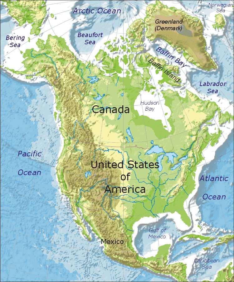
5 5
6 Assignment 1: Label the physical map of North America above with the following: Canada Great Lakes Mexico Mississippi River Rio Grande Rocky Mountains (draw ^^^ to represent mountains) Appalachian Mountains (remember to use symbol ^^^) West Indies Atlantic Ocean Pacific Ocean Gulf of Mexico Central America 6 2. South America a. Located in the Western Hemisphere, south of Central America b. 4 th largest continent in area c. Over 7000 miles in length d. Physical features i. Mountains 1. Andes: longest mountain chain in the world and among the highest in elevation, over 4,500 mi. long, once the basis of the Inca Empire ii. Grasslands and Plains 1. Mountains and poor soil make much of South America s land unproductive. 2. Pampas: in Argentina provide LARGE areas of fertile land and soil for growing crops and raising cattle iii. Rainforests 1. East coast of Central America 2. Northern part of South America 3. Amazon Rainforest: largest in the world, in Brazil

7 7 iv. Bodies of Water 1. Amazon River: 2 nd longest in the world 2. Orinoco River 3. Rio de la Plata 4. A large percentage of Brazil s population lives on or near these river systems v. Climate 1. Much of South America is warm because of its location near the equator 2. Many places, however have cool and even freezing temperatures because of altitude and/or latitude
8 Assignment 2: Using the outline map above, locate and label the following: Andes Mountains (use ^ symbol for mountains) Pampas Amazon River Equator Chile Peru Brazil Argentina Amazon Rainforest Rio de Janeiro Caribbean Sea Pacific Ocean Atlantic Ocean 3. Africa a. 2 nd largest continent in area b. Almost three times the size as the U.S. c. Physical Features i. Deserts 1. Sahara: a. World s largest desert b. Separates North and South Africa, largely due to climate and religion 2. Kalahari Desert ii. Savannas 8

9 1. Land where tall, wild grasses grow with some trees 2. The best areas in Africa for growing crops and raising livestock 3. Most Africans live in the savanna region, along the coasts or along the rivers. iii. Tropical Rainforests 1. In Central and West Africa 2. Hot and humid 3. Get inches of rainfall per year iv. Mountains and Valleys 1. Atlas Mountains: northwest edge of Africa 2. Great Rift Valley: runs through the highlands of Ethiopia to Kenya v. Bodies of Water 1. Nile River: Longest river in the world 4,150 miles 2. Lake Victoria 3. Lake Tanganyika 4. Lake Nyasa vi. Climate 1. Much of Africa warm, with hot summers and mild winters 2. Amount of rain differs greatly 9

10 10 4. Europe a. Second smallest continent in land area b. Shares the same land mass with Asia c. Separated and divided by the Ural Mountains d. Physical Features i. Mountains 1. Alps 2. Pyrenees: separate Spain and France

11 11 3. Apennines: run through the center of Italy 4. Balkans 5. The mountains encouraged Europeans to form many separate nationalities, each with its own language and customs. ii. Bodies of Water 1. Baltic Sea 2. North Sea 3. Mediterranean Sea 4. Black Sea 5. Danube River 6. Rhine River 7. Loire River 8. Volga River

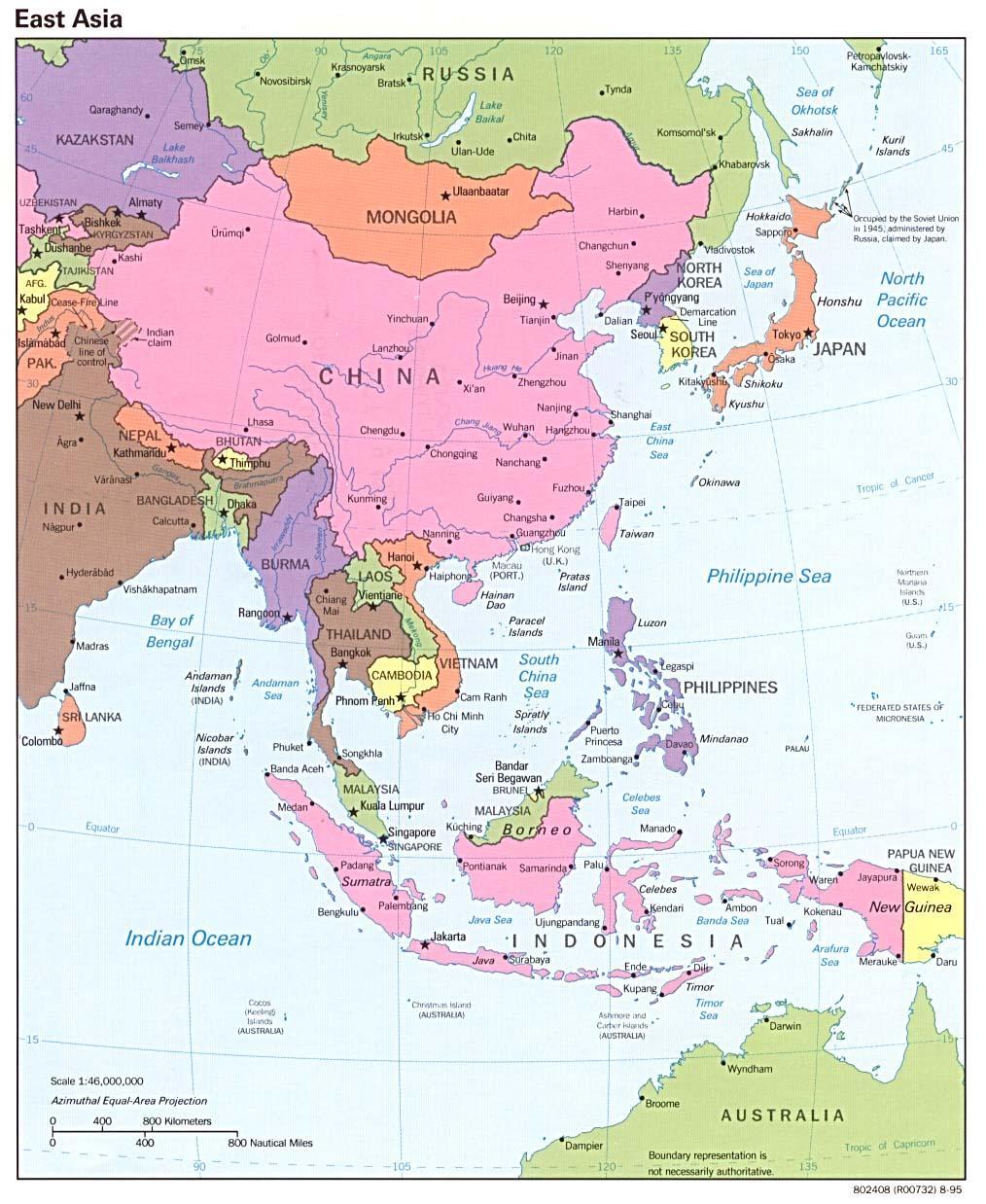
12 5. Asia a. The world s largest continent b. Composed of several distinct regions i. The Middle East (Southwest Asia) 1. Lies at the crossroads of three continents a. Africa b. Europe c. Asia 2. Suez Canal: important chokepoint 3. Physical features: a. Deserts: Arabian Desert, Syrian Desert b. Bodies of Water: i. Jordan River ii. Tigris and Euphrates Rivers iii. Mediterranean Sea iv. Black Sea v. Red Sea vi. Persian Gulf c. Climate and Resources i. Most of Southwest Asia lies along the equator ii. Generally lacks adequate water iii. Holds about half of the world s known oil reserves ii. North and Central Asia 1. Northern Asia is occupied by Russia, the world s largest country in area a. Most of the population is located in European Russia b. Most of the land mass is in Asian Russia 2. Central Asia 12
13 13 a. Made up of vast amounts of mountains, deserts and steppes (treeless grasslands) 3. Siberia: extremely cold region with forests 4. Tundra: northern most part of Russia 5. Bodies of Water a. Arctic Ocean b. Ob and Lena River 6. Mountains a. Ural Mountains: separate Europe from Asia b. Pamir Mountains: separate Russia from China 7. Climate a. Most of Russia has long, cold winters and short mild summers iii. East Asia 1. Includes three important countries a. China (third largest country in the world, after Russia and Canada): the world s most populous nation b. Korea (North and South) c. Japan: consists of four major islands and thousands of smaller ones 2. Bodies of water a. Yangtze and Yellow River: birthplace of early civilizations 3. Mountains a. Himalayan b. Kunlun c. Tianjin d. Plateau of Tibet e. Mount Fuji: extinct volcano and highest point in Japan 4. Deserts a. Gobi: located to the north of China in Mongolia
14 14

15 iv. South and Southeast Asia 1. South Asia is a subcontinent-a large piece of land smaller than a continent a. The Indian subcontinent looks like a large triangle jutting out into the Indian Ocean 2. Southeast Asia a. Consists of a peninsula and a series of islands. 3. Physical features a. Himalayas i. Highest mountain range in the world ii. Separate India from the rest of Asia 4. Bodies of water a. India i. Indus and Ganges River b. Southeast Asia i. Mekong River ii. Salween River iii. Irrawaddy River 5. Climate a. Warm winters and hot summers b. Monsoons: seasonal winds that bring heavy rains 6. Australia a. Surrounded by the Indian and Pacific Oceans b. Great Barrier Reef: the world s largest coral reef c. The only country that is an entire continent 15


16 7. Antarctica a. World s southernmost continent b. Covers the South Pole c. Surrounded by the Southern, Atlantic, Pacific and Indian Ocean d. The coldest, driest and windiest, and has the highest average elevation of all the continents e. International research station, used only by scientists Regions Just as historians divide time into distinct time periods, geographers divide the Earth into distinct regions. Each region has characteristics that set it apart from other regions. Regions can be based on human or physical characteristics. Physical Regions Defined as common landforms, soils, climate, vegetation, or animal life. 16
17 Formal Regions Has clear boundaries and is usually defined by having a common property, such as low rainfall. 17
Tropical Moist Rainforest
 Tropical or Lowlatitude Climates: Controlled by equatorial tropical air masses Tropical Moist Rainforest Rainfall is heavy in all months - more than 250 cm. (100 in.). Common temperatures of 27 C (80 F)
Terms, People, and Places. Five Themes of Geography: Three Kinds of Maps: Natural Resources: Land Terms: Water Terms:
 Terms, People, and Places Five Themes of Geography: Three Kinds of Maps: Natural Resources: Land Terms: Water Terms: Lesson Objectives Explain how geography impacts human development Analyze how human
WG.21.C Create and interpret different types of maps to answer geographic questions, infer relationships, and analyze change.
 Unit: Essentials Cartography (Maps) Social Studies Skills Standards: WG.21.A Analyze and evaluate the validity, and utility of multiple sources of geographic information such as primary and secondary sources,
September 14, 2013 Objective: How does geography impact history? What important features exist that have shaped societies?
 Lowenhaupt 1 September 14, 2013 Objective: How does geography impact history? What important features exist that have shaped societies? Warm-Up: In your binder, answer the following question: Imagine you
Module 11: Meteorology Topic 3 Content: Climate Zones Notes
 Introduction Latitude is such an important climate factor that you can make generalizations about a location's climate based on its latitude. Areas near the equator or the low latitudes are generally hot
Chapter 21 Southwest Asia: Harsh & Arid Lands
 Name Hour Chapter 21 Southwest Asia: Harsh & Arid Lands Essential Question: How has the physical geography of Asia influenced the development of these regions (i.e. history, population distribution, &
Unit 2. United States Physical Geography
 Unit 2 United States Physical Geography Physical Geography U.S. extends from the Atlantic to Pacific U.S. is the 3rd largest country U.S. has fertile soils, vast forests, and variety of minerals All major
forest tropical jungle swamp marsh prairie savanna pampas Different Ecosystems (rainforest)
") Different Ecosystems forest A region of land that is covered with many trees and shrubs. tropical jungle (rainforest) swamp A region with dense trees and a variety of plant life. It has a tropical climate.
Different Ecosystems forest A region of land that is covered with many trees and shrubs. tropical jungle (rainforest) swamp A region with dense trees and a variety of plant life. It has a tropical climate.
South, Southeast, and East Asia. Physical Geography
 South, Southeast, and East Asia Physical Geography Mountains v Mountains are important in Asia because they influence: A. Population patterns B. Movement of people and goods C. Climate Mountains v The
EQ: Discuss main geographic landforms of the U.S. & Canada and examine varied landforms in relation to their lifestyles.
 EQ: Discuss main geographic landforms of the U.S. & Canada and examine varied landforms in relation to their lifestyles. Places & Terms for Discussion Appalachian Mountains Great Plains Canadian Shield
AP Environmental Science. Earth Systems: Part 3
 AP Environmental Science Earth Systems: Part 3 River Deep, Mountain High Geomorphology-the scientific study of landforms and the processes that shape them Water, water everywhere.. Oceans Arctic Ocean
GLOBAL CLIMATES FOCUS
 which you will learn more about in Chapter 6. Refer to the climate map and chart on pages 28-29 as you read the rest of this chapter. FOCUS GLOBAL CLIMATES What are the major influences on climate? Where
CHAPTER 1. Geo Challenges 1A to 1D. & World Map Activity
 CHAPTER 1 Geo Challenges 1A to 1D & World Map Activity SELECT YOUR CHALLENGE World Map Activity Challenge 1A Challenge 1B Challenge 1C Challenge 1D Challenge 1A WS PG. 2 STEP #1 Label the largest continent
What is the largest country in the world? Russia
 What is the largest country in the world? #1 Russia CSCOPE 2007 2 Russia Dimensions #2-3 Spans 11 Time Zones From East to West: Gulf of Finland to Alaska From North to South: Above the Arctic Circle to
1. Match the words in the first column to the meaning in the second column. [5]
![1. Match the words in the first column to the meaning in the second column. [5]](/thumbs/96/126839765.jpg "1. Match the words in the first column to the meaning in the second column. [5]") Exercise 1: [40 POINTS] 1. Match the words in the first column to the meaning in the second column. [5] Equator Around earth between the Equator and the Poles. Greenwich meridian Half of earth. Longitude
Exercise 1: [40 POINTS] 1. Match the words in the first column to the meaning in the second column. [5] Equator Around earth between the Equator and the Poles. Greenwich meridian Half of earth. Longitude
Chapter 1 Section 2. Land, Water, and Climate
 Chapter 1 Section 2 Land, Water, and Climate Vocabulary 1. Landforms- natural features of the Earth s land surface 2. Elevation- height above sea level 3. Relief- changes in height 4. Core- most inner
Pre-AP World Geography Summer Assignment
 Pre-AP World Geography 2018-2019 Summer Assignment This is the summer assignment for students who intend on being accepted and enrolled in Pre-AP World Geography. Successful performance on this assignment
Grade 7 History Mr. Norton
 Grade 7 History Mr. Norton Section 1: Thinking Geographically Section 2: Land and Climates of the United States Section 3: The Tools of History Section 4: Economics and Other Social Sciences Grade 7 History
1 What Is Climate? TAKE A LOOK 2. Explain Why do areas near the equator tend to have high temperatures?
 CHAPTER 17 1 What Is Climate? SECTION Climate BEFORE YOU READ After you read this section, you should be able to answer these questions: What is climate? What factors affect climate? How do climates differ
World Geography Chapter 3
 World Geography Chapter 3 Section 1 A. Introduction a. Weather b. Climate c. Both weather and climate are influenced by i. direct sunlight. ii. iii. iv. the features of the earth s surface. B. The Greenhouse
STUDENTS ACTIVITIES UNIT 1 UNIT 2
 STUDENTS ACTIVITIES UNIT 1 UNIT 2 Unit 1: The Earth UNIT 1 THE EARTH...2 1. CONTINENTS AND OCEANS...2 2. THE EARTH S RELIEF...5 2.1THE STRUCTURE OF THE EARTH...5 2.2FEATURES OF RELIEF...7 2.3PHYSICAL MAP...10
Terms. divide headwaters tributary fall line fishery
 Chapter 5 Preview Section 1 The Land Objectives Identify some key similarities and differences in the physical geography of the United States and Canada. Explain why rivers have played such an important
Mount Everest and the Gobi Desert
 Mount Everest and the Gobi Desert 1 Mount Everest is part of the mountain chain known as the Himalaya. Adventurers from all over the world come to try to climb it. Mount Everest is the highest mountain
Chapter 1: The Geography of the Western Hemisphere
 Chapter 1: The Geography of the Western Hemisphere Chapter 1, Lesson 1: The Changing Earth Objectives: - You will be able to identify the major natural events that cause the earth to change. - You will
Unit 1: Geography. For additional information, refer to this website: 1 G e o g r a p h y
 Unit 1: Geography For additional information, refer to this website: http://mryoungtms.weebly.com/ 1 G e o g r a p h y Continents and Oceans SOL USI. 2a Essential Understanding: Continents are large land
1 What Is Climate? TAKE A LOOK 2. Explain Why do areas near the equator tend to have high temperatures?
 CHAPTER 17 1 What Is Climate? SECTION Climate BEFORE YOU READ After you read this section, you should be able to answer these questions: What is climate? What factors affect climate? How do climates differ
Europe, Canada, Latin America, & Australia
 Europe, Canada, Latin America, & Australia EUROPE SS6G8 The student will locate selected features of Europe. a. Locate on a world and regional political- physical map: the Danube River, Rhine River, English
Biomes There are 2 types: Terrestrial Biomes (on land) Aquatic Biomes (in the water)
 Aquatic Biomes (in the water)") Biomes There are 2 types: Terrestrial Biomes (on land) Aquatic Biomes (in the water) Terrestrial Biomes Grassland, Desert, and Tundra Biomes: Savanna Temperate grassland Chaparral Desert Tundra Chapter
Biomes There are 2 types: Terrestrial Biomes (on land) Aquatic Biomes (in the water) Terrestrial Biomes Grassland, Desert, and Tundra Biomes: Savanna Temperate grassland Chaparral Desert Tundra Chapter
Unit 1: Basics of Geography Test Review
 Name Date Period Unit 1: Basics of Geography Test Review Directions: Reading the following sections and complete the questions, charts, and diagrams. Types of Maps Maps that have a particular theme are
Major Domain of the Earth
 Major Domain of the Earth The surface of the earth is a complex zone in which three main components of the environment meet, overlap and interact. The solid portion of the earth on which we live is called
WHAT CAN MAPS TELL US ABOUT THE GEOGRAPHY OF ANCIENT GREECE? MAP TYPE 1: CLIMATE MAPS
 WHAT CAN MAPS TELL US ABOUT THE GEOGRAPHY OF ANCIENT GREECE? MAP TYPE 1: CLIMATE MAPS MAP TYPE 2: PHYSICAL AND/OR TOPOGRAPHICAL MAPS MAP TYPE 3: POLITICAL MAPS TYPE 4: RESOURCE & TRADE MAPS Descriptions
... Europe. Based on Bloom s Taxonomy. Environment Interactions Movement. Human & Location. Regions. Place
 ... Europe Location Place Human & Environment Interactions Movement Regions LEVEL 1 Knowledge Match Show or Label List Information Recall Details (5Ws + H) Find Information LEVEL 2 Comprehension Describe
Our climate system is based on the location of hot and cold air mass regions and the atmospheric circulation created by trade winds and westerlies.
 CLIMATE REGIONS Have you ever wondered why one area of the world is a desert, another a grassland, and another a rainforest? Or have you wondered why are there different types of forests and deserts with
The Impact of Geography in South and East Asia
 The Impact of Geography in South and East Asia Gobi desert, Mongolia Essential Question: How does the geography of SE Asia impact trade and the distribution of population throughout the region? (AKS #52a)
AP Human Geography PROJECT
 AP Human Geography PROJECT WORLD MAPS Name Period Date This is a self-study of the geography of the world. You are to make three maps as described below. Each map is worth 100 points (30 points off if
Sec$on 1: Geography and Early China. How does China s geography affect the culture?
 Sec$on 1: Geography and Early China How does China s geography affect the culture? Con$nents of the World Label the continents. Where is China located? Where is China located? In your groups, begin filling
AP Human Geography PROJECT
 AP Human Geography PROJECT WORLD MAPS Name Period Date This is a self-study of the geography of the world. You are to make three maps as described below and complete two worksheets. Each project is worth
Continents. and. Oceans
 Continents and Oceans Continents and Oceans Africa Africa Antarctica Antarctica Asia Asia Australia Australia Europe Europe North America North America South America South America World Map World Map Continents
On Earth, the land is broken into large pieces. These pieces are separated by large bodies of water called oceans. We call some of these pieces of
 The 7 Continents On Earth, the land is broken into large pieces. These pieces are separated by large bodies of water called oceans. We call some of these pieces of land continents. A continent is an area
1 What Is Climate? TAKE A LOOK 2. Explain Why do areas near the equator tend to have high temperatures?
 CHAPTER 3 1 What Is Climate? SECTION Climate BEFORE YOU READ After you read this section, you should be able to answer these questions: What is climate? What factors affect climate? How do climates differ
1 st Term Test 2014 Maris Stella College - Negombo. Geography
 Grade 9 1 st Term Test 2014 Maris Stella College - Negombo Geography 2 Hour Name(. Class ( No ( Use MCQ paper to answer Part 1. 1) What is the Blue Planet? i. Neptune iii. Uranus ii. Earth iv. Merury 2)
Map Skills Scavenger Hunt
 Map Skills Scavenger Hunt Introduction to: Continents Cardinal Directions Relative Location Equator and Prime Meridian Hemispheres Reading a Political Map Reading a Physical Map Idea: This product includes
Chapter 1. Social Studies History and Geography
 Chapter 1 Social Studies History and Geography Unit 01 Geography Skills 1 Reading Maps Key Words border landform rely on display focus on route locater 1 There are many different kinds of maps. A political
Chapter 6, Part Colonizers arriving in North America found extremely landscapes. It looked different to region showing great.
 Social Studies 9 Unit 1 Worksheet Chapter 6, Part 1. 1. Colonizers arriving in North America found extremely landscapes. It looked different to region showing great. 2. The Earth is years old and is composed
AP Human Geography World Atlas Project
 AP Human Geography World Atlas Project - 2018 Welcome to Robert E. Lee High School and Advanced Placement Human Geography! You are going to thoroughly enjoy this class. It will be a lot of work, but the
Unit 1: Geography GeoTrekkers in the Western Hemisphere. Illustrated Glossary
 Unit 1: Geography GeoTrekkers in the Western Hemisphere Illustrated Glossary adapt to change in order to fit new condi/ons archipelago a group or chain of islands clustered together in a sea or ocean bodies
World Geography Copywork
 World Geography Copywork Copyright 2015 Janeen Herlugson This copywork pack is intended to enhance your child's knowledge of World Geography. It is not a Geography Curriculum, nor a complete Geography
The Impact of Geography in South and East Asia
 The Impact of Geography in South and East Asia Gobi desert, Mongolia Essential Question: How does the geography of SE Asia impact trade and the distribution of population throughout the region? (AKS #52a)
7.1.spi.2. locate cultural information definitions (i.e., language, on a thematic map (i.e., languages, religion, customs, political
 Standards Term 1 Term 2 Term 3 Term 4 Throughout Year 7.1.spi.1. recognize cultural 7.1.spi.2. locate cultural information definitions (i.e., language, on a thematic map (i.e., languages, religion, customs,
Social Studies: The World Post Test Study Guide
 Name: Period: Social Studies: The World Post Test Study Guide Map and Globe Skills: Label the continents and oceans on the lines below the map. 1 11 3 4 5 8 2 9 10 8 6 7 1. 8. 2. 9. 3. 10. 4. 11. 5. 6.
Static GK. World Geography. innovation. Assignment 01
 Static GK World Geography innovation Assignment 01 World Geography Practice Assignment 01 Direction for question 1-35: Mark the best option. 1. Which strait separates Europe from Africa? A) Mallaica B)
4th Grade U.S. Regional Geography
 4th Grade U.S. Regional Geography Multiple Choice Identify the choice that best completes the statement or answers the question. What does the term mainland mean in the sentence above? A the continent
4th Grade Social Studies First Nine Weeks
 4th Grade Social Studies First Nine Weeks Multiple Choice Identify the choice that best completes the statement or answers the question. 1 Name the mountains that are located in the eastern United States.
This image cannot currently be displayed. Course Catalog. History and Geography Glynlyon, Inc.
 This image cannot currently be displayed. Course Catalog History and Geography 2016 Glynlyon, Inc. History and Geography Table of Contents COURSE OVERVIEW... 1 UNIT 1: OUR EARTH... 1 UNIT 2: SEAPORT CITIES...
The Impact of Geography in South and East Asia
 The Impact of Geography in South and East Asia Gobi desert, Mongolia Essential Question: How does geography impact the distribution of population throughout South and East Asia? I CAN Explain how geography
Thursday, November 3, 2016.
 Hunter College-CUNY GEOG 101 Atlas Extra Credit for Exam II The extra credit exercises associated with each third of the course are worth a maximum of 5 points added to your exam score at the end of each
Your task: 11 - Lena 4,400 km 12 - Mekong 4,350 km 13 - Mackenzie 4,241 km 14 - Niger 4,200 km 15 - Murray-Darling 3,672 km
 1 Your task: Using an atlas to help you, identify each of these rivers marked on the map above. The first one is done for you. 1 - Nile 6,650 km 2 - Amazon 6,400 km 3 - Yangtze 6,300 km 4 - Mississippi
Downloaded from
 I II III IV V VI Define the following terms:- a) Orbitb) Meteoroids c) Celestial bodies GEOGRAPHY ASSIGNMENTS The Earth In The Solar System d) Satellite e) Comets Give one word answers:- a) Blue planet
Chapter 3 Section 3 World Climate Regions In-Depth Resources: Unit 1
 Guided Reading A. Determining Cause and Effect Use the organizer below to show the two most important causes of climate. 1. 2. Climate B. Making Comparisons Use the chart below to compare the different
Natural Texas. Regions and Climates
 Natural Texas Regions and Climates Two Kinds: Physical geography Climate, vegetation, rivers, lakes, oceans, plateaus, plains, and mountain ranges Human geography Economic activities How we earn a living
Iceland. 1. Warm up. A. Talk about the picture and read the essay. B. Discuss the questions about the essay.
 1. Warm up A. Talk about the picture and read the essay. Iceland My country, Iceland, is one of the most beautiful countries on Earth. It is an island country. It is located in Europe, in the North Atlantic
A Global View. We Understand the World Better by Studying:
 Graphic Organizer A Global View We Understand the World Better by Studying: The Continents Physical Features Human Features Human/Environment Interaction Global Patterns Michigan Citizenship Collaborative
MR. JOHNSON S. Geography OHIO COUNTY MIDDLE SCHOOL
 MR. JOHNSON S Geography OHIO COUNTY MIDDLE SCHOOL CHAPTER 1 Geography The science of geography is likely the oldest of all sciences. Geography is the answer to the question that the earliest humans asked,
Chapter 32. Australia & New Zealand
 Chapter 32 Australia & New Zealand Lesson 1: Physical Geography of Australia & New Zealand Landforms Australia lies between the Pacific and Indian Oceans in the Southern Hemisphere. Although an island,
Physical Geography of the United States and Canada Chapter 5 A Land of Contrasts
 Physical Geography of the United States and Canada Chapter 5 A Land of Contrasts Land Area Together the U.S. and Canada cover more than 7 million square miles. In total area, Canada ranks 2 nd and the
East Asia. Mongolia, China, Taiwan, the Koreas, and Japan
 East Asia Mongolia, China, Taiwan, the Koreas, and Japan Major Geographic Characteristics of East Asia East Asia is the most populous region in the world China is the most populous country, and the oldest
Maps and Globes. By Kennedy s Korner
 Maps and Globes By Kennedy s Korner Map Key or Symbols Maps use symbols to show places and things on Earth. Symbols are drawings that stand for something real. A map key tells you what each symbol stands
Name Date Class. well as the inland, found near the Tropics. 4. In the, or the regions near the Equator, you may find a lush
 WATER, CLIMATE, AND VEGETATION Vocabulary Activity DIRECTIONS: Fill in the Blanks Select a term from below to complete each of the following sentences. CHAPTER 1. The constant movement of water, a process
Contents. Section 1: Climate Factors. Section 2: Climate Types. Section 3: Climate Effects
 Contents Section 1: Climate Factors 1. Weather or Climate?.... 2 2. Elements of Climate.... 4 3. Factors Affecting Climate.... 10 4. Comparing Climates.... 15 5. Quiz 1.... 20 Section 2: Climate Types
Unit 1: Geography CLASS WEBSITE: QUIZLET GAMES: ONLINE RESOURCES
 Unit 1: Geography ONLINE RESOURCES CLASS WEBSITE: HTTPS://MRYOUNGTMS.WEEBLY.COM/GEOGRAPHY.HTML QUIZLET GAMES: HTTPS://QUIZLET.COM/JOIN/MSFYY94T5 1 G e o g r a p h y Continents and Oceans The Seven Continents
Understanding Projections
 GEOGRAPHY SKILLS 1 Understanding Projections The earth is a sphere and is best shown as a globe. For books and posters, though, the earth has to be represented as a flat object. To do this, mapmakers create
Why VOCABULARY? clues
 It s GHSGT Time! Why VOCABULARY? Social Studies is all about MAKING CONNECTIONS Key Terms provide relational clues to guide you in answering test questions! The more WORDS you know, the smarter you are
Simple Solutions Social Studies Level 2. Level 2. Social Studies. Help Pages
 Level 2 Social Studies 147 148 adobe houses with bricks made of clay and straw ancestor a family member who lived before us appoint choose; leaders can appoint others barter trading one thing for another
The United States & Canada. A Regional Study of Anglo America
 A Regional Study of Anglo America Landform Regions of the United States & Canada world leaders in agricultural and industrial production because of... VAST LANDS stretch from the Atlantic Ocean on the
Map Skills Test. 1. What do we call a person who makes maps? a. mapographer b. cartographer c. geologist d. archaeologist
 Map Skills Test 1. What do we call a person who makes maps? a. mapographer b. cartographer c. geologist d. archaeologist 2. What is the name of the 0 latitude line? a. Equator b. Arctic Circle c. First
UNIT 3: THE CONTINENTS
 UNIT 3: THE CONTINENTS TOPICS 1. The continents 2. Europe 3. Africa 4. America 5. Asia 6. Oceania 7. Antarctica 8. Relief of Spain 1. The continents The Earth consist of six continents: Europe, Africa,
Chapter 1. Global agroclimatic patterns
 14 CROPWATCH BULLETIN FEBRUARY 2018 Chapter 1. Global agroclimatic patterns Chapter 1 describes the CropWatch Agroclimatic Indicators (CWAIs) rainfall (RAIN), temperature (TEMP), and radiation (RADPAR),
Chapter 32. Australia & New Zealand
 Chapter 32 Australia & New Zealand Lesson 1: Physical Geography of Australia & New Zealand Landforms Australia lies between the Pacific and Indian Oceans in the Southern Hemisphere. Although an island,
STUDY GUIDE. The Land. Physical Features. Australia. Oceania. Chapter 32, Section 1. New Zealand Antarctica. Terms to Know DRAWING FROM EXPERIENCE
 For use with textbook pages 793 798. The Land Terms to Know artesian well A well from which pressurized water flows to the surface (page 794) coral The limestone skeletons of tiny sea animals (page 795)
Pre AP World Geography Summer Project
 Part of the Pre AP goal is to have a deeper understanding of the impact of physical and political locations on each other. This project is designed to ensure that you have a strong foundation of the locations
(version 3) I. HumAN -Environment Interaction
 I. HumAN -Environment Interaction") (version 3) I. HumAN -Environment Interaction A. Landforms 1. Earth s topography is made up of many different types of landforms. 2. While the planet is covered primarily with water, the four major types
(version 3) I. HumAN -Environment Interaction A. Landforms 1. Earth s topography is made up of many different types of landforms. 2. While the planet is covered primarily with water, the four major types
Introduction to Geography
 Introduction to Geography ropic of Cancer 3½ N Arctic Circle 90 N Prime Meridian 0 Arctic Ocean Mississippi R. Appalachian Mts. Europe Rocky Mountains N. America Atlantic Gulf of Ocean Mexico Caribbean
IR-20: Weather/Climate Venn Diagram. Weather Climate Region 4 Education Service Center Geography by Design, Volume 1
 IR-20: Weather/Climate Venn Diagram Weather Climate 2013 Region 4 Education Service Center Geography by Design, Volume 1 IR-21: Climate Scenario Cards Scenario 1: You are on vacation at a location on the
*Turn to Left Side 29*
 Homework: Africa Geo. Quiz Tuesday (pages 28-30) Do Now: Define in I.N. Glossary: Climate - average weather Vegetation Regions - areas where there are similar plants. Example: forests, deserts and grasslands.
Chapter 6 Processes Shaping Planet Earth
 Chapter 6 Processes Shaping Planet Earth In this chapter, you will learn about Earth s lithosphere (Earth s crust and landforms), hydrosphere (oceans and other bodies of water), atmosphere (layers of gases
Fig Major air masses of the world
 Fig. 9.3 Major air masses of the world CLASSIFICATION FOUR BASIC CATEGORIES OF AIR MASSES: POLAR - P ARCTIC - A TROPICAL - T EQUATORIAL - E TWO DESIGNATIONS OF SURFACE IN SOURCE REGION MARITIME - m. CONTINENTAL
Australia and New Zealand: Powerpoint
 Australia and New Zealand: Powerpoint Physical Geography Australia and New Zealand are between the Indian and Pacific Oceans. Australia s seasons are opposite of the United States due to their location.
Explain the impact of location, climate, natural resources, and population distribution on Europe. a. Compare how the location, climate, and natural
 SS6G10 Explain the impact of location, climate, natural resources, and population distribution on Europe. a. Compare how the location, climate, and natural resources of Germany, the United Kingdom and
Population And Settlement Part I
 Population And Settlement Part I 0011 0010 1010 1101 0001 0100 1011 4 12 Think of the earth as a living organism that is being attacked by billions of bacteria whose numbers double every forty years. Either
Landforms and Bodies of Water
 Chapter 5, Section 1 For use with textbook pages 115 120. The Land Terms to Know divide A high point or ridge that determines the direction that rivers flow (page 118) headwaters The source waters of a
L.O Students will learn about factors that influences the environment
 Name L.O Students will learn about factors that influences the environment Date 1. At the present time, glaciers occur mostly in areas of A) high latitude or high altitude B) low latitude or low altitude
Physical Geography of East Asia
 Physical Geography of East Asia Satellite View of China Landforms of China China s Geography China Miles 0 250 500 1,000 1,500 2,000 United States 3 rd largest country in the world. Comparable to the US
What is the name of the continent that is labeled #1 on the map?
 What is the name of the continent that is labeled #1 on the map? North America What is the name of the continent that is labeled #2 on the map? South America What is the name of the continent that is labeled
Socorro Independent School District World Geography 3 rd 9 Weeks. Culture. Government. European Terminology
 Unit Essential Questions SE Monday Tuesday Wednesday Thursday Friday Unit 05: Latin America Unit 6: How did the major landforms of Latin America impact its developmen t? How is Latin American history a
Terms to Know. divide headwaters tributary fall line fishery
 Chapter Objectives Describe the dominant landforms and natural resources of the United States and Canada. Discuss climate and vegetation in the United States and Canada. Section 1 The Land Section Objectives
Sixth Grade Social Studies. QPA Schedule
 2017 2018 Sixth Grade Social Studies Unit 1: Concepts Used in Global Studies 5 Weeks Unit 2: History & Geography of Europe 5 Weeks Unit 3: Europe Today 6 Weeks Unit 4: History & Geography of Latin America
2 Georgia: Its Heritage and Its Promise
 TERMS region, erosion, fault, elevation, Fall Line, aquifer, marsh, climate, weather, precipitation, drought, tornado, hurricane, wetland, estuary, barrier island, swamp PLACES Appalachian Mountains, Appalachian
Keys to Climate Climate Classification Low Latitude Climates Midlatitude Climates High Latitude Climates Highland Climates Our Changing Climate
 Climate Global Climates Keys to Climate Climate Classification Low Latitude Climates Midlatitude Climates High Latitude Climates Highland Climates Our Changing Climate Keys to Climate Climate the average
Geography Long Term Plan 2018
 Geography Long Term Plan 2018 Geography Co-ordinator: Megan Frost A high-quality geography education should inspire in pupils a curiosity and fascination about the world and its people that will remain
FTCE Social Science 6-12
 COMPETENCY 1.0 KNOWLEDGE OF GEOGRAPHY Skill 1.1 Apply the six essential elements of geography. GEOGRAPHY involves studying location and how living things and earth's features are distributed throughout