Cherry County, Nebraska
|
|
|
- Katrina Fitzgerald
- 5 years ago
- Views:
Transcription
 534-9240 Telecopier (308) 534-9244 Information contained herein was obtained for sources deemed reliable. We have no reason to doubt the accuracy, but we do not guarantee it.")
1 Cherry County, Nebraska Co-Listed with Maddux Landbanc Realty, LLC Offered Exclusively By: NORTH PLATTE OFFICE P.O. Box 1166 I-80 & US Hwy 83 North Platte, NE (308) Telecopier (308) Information contained herein was obtained for sources deemed reliable. We have no reason to doubt the accuracy, but we do not guarantee it. Prospective Buyers should verify all information, including items of income and expense.


2 Location: Cross Ranch The headquarters are 9 miles west of Merriman, Nebraska on Hwy 20 and the east pasture joins the south side of Merriman on Hwy 61. Land Use: The West Unit is the headquarters and wintering unit. It has approximately 600 acres of wet meadow around Coffey Lake. Leander Creek flows through the property. The improvements consist of a beautiful brick home overlooking the hay meadow and lake, a hired man s house, a newer steel pole building, calving shed, large older barn, shop and good set of working pens. The East Unit has Leander Creek flowing 4 miles through the property. It is primarily used for summer grazing with excellent access on both sides of Hwy 61. Carrying Capacity: Water: Carrying capacity is rated by the owner at 600 cow units (heifers & bulls) on a yearround basis The ranch is very well watered with a good distribution of 17 windmills and Coffey Lake, as well as Leander Creek that flows through both units.
3 Taxed Acres: Cross Ranch West Unit - 3, tax assessed acres East Unit - 7, tax assessed acres Taxes: 2011 taxes payable in 2012 are $45, Price: $5,659,500 Contact: Mike Polk, Co-Listing Agent (308) or mike@agriaffiliates.com Or Sonny Maddux, Co-Listing Agent (308) or madduxlandbanc@yahoo.com Bruce Dodson, Loren Johnson, Jerry Weaver, Roger Luehrs, Dallas Dodson OUT Headquarters West Unit East Unit Highway 20 Highway 61

4 Exhibit A Legal Description Legal Acres ALL Section 3-T33N-R37W ALL except Hwy 61 ROW Section 4-T33N-R37W 640 N1/2, E1/2SW1/4, PT NW1/4SE1/4, PT N1/2S1/2 East of Hwy 61 Section 5-T33N-R37W 472 N1/2 Section 6-T33N-R37W PT E1/2 NW1/4 Lying West of Hwy 61 Section 8-T33N-R37W 78.4 NE1/4, E1/2NW1/4 Section 9-T33N-R37W 240 ALL Section 10-T33N-R37W 640 W1/2W1/2, SE1/4SW1/4 Section 4-T33N-R38W ALL Section 5-T33N-R38W N1/2, SE1/4, N1/2SW1/4, SE1/4SW1/4 Section 6-T33N-R38W N1/2, N1/2SE1/4, SW1/4 Section 1-T33N-R39W PT E1/2 East of Hwy 20 Section 2-T33N-R39W 68.3 PT SE1/4NE1/4 Section 11-T33N-R39W 29.8 PT NE1/4NE1/4 East of Hwy 20 Section 11-T33N-R39W 35 NW1/4 Section 12-T33N-R39W 160 PT N1/2 SW1/4, S1/2SW1/4, PT NW1/4SE1/4. SW1/4SE1/4, PT E1/2SE1/4 Section 18-T34N-R37W ALL except Tracts 1 & 2 Section 19-T34N-R37W W1/2W1/2, PT E1/2NW1/4, PT E1/2SW1/4 except Tracts 1 & 2 Section 20-T34N-R37W PT SW1/4SW1/4 West of Road Section 28-T34N-R37W 3.9 PT W1/2, PT S1/2NE1/4, PT SE1/4 Lying West of Hwy 61 Section 29-T34N-R37W 446 ALL except Hwy 61 ROW Section 30-T34N-R37W ALL Section 31-T34N-R37W ALL Section 32-T34N-R37W 640 SE1/4, E1/2SW1/4, PT W1/2SW1/4 Section 33-T34N-R37W 264 PT W1/2W1/2 West of the Road Section 33-T34N-R37W 106 S1/2 Section 34-T34N-R37W 320 E1/2, E1/2W1/2 Section 25-T34N-R38W 480 S1/2, PT NW1/4, S1/2NE1/4 Section 31-T34N-R38W 550 SW1/4NW1/4, W1/2SW1/4, SE1/4SW1/4, SW1/4SE1/4 Section 32-T34N-R38W 200 PT SE1/4 Section 25-T34N-R39W PT E1/2SE1/4 Section 35-T34N-R39W 1.22 ALL except Hwy 20 ROW 36-T34N-R39W Total Acres 11,319.01


5 WATER AVAILABILITY IN THE NEBRASKA SANDHILLS The historic Nebraska Sandhills occupy 19 million acres in west central Nebraska. Stretching from Alliance on the west to Neligh on the east, the Sandhills are primarily south of the Niobrara River and north of the Platte River. Formed in very recent geologic time, these sand dunes are held in place by warm season grasses. Although there are differences in rainfall, growing season and terrain, the entire Sandhills area enjoys an abundance of underground water. Research wells at Hyannis, Nebraska, indicate over 1,400 feet of sand saturated with 1,400 feet of water. Surface water varies in different communities of the Sandhills with an abundance of small lakes throughout the western, northern & eastern portions. Most ranches in those areas enjoy an abundance of sub -irrigated meadows and therefore native hay production for year-round balance of the ranch. Annual precipitation varies from 16 inches at Alliance to more than 23 inches in eastern portions of the Sandhills. A unique feature is that every drop of precipitation is absorbed by the Ranch sand (sponge), with virtually no run-off. The Sandhills do include a number of smaller streams/ rivers. Water in these streams is nearly 100% from springs with essentially no variation throughout the year. The Sandhills of Nebraska provide an excellent environment for production of beef cattle. Depending on the extent of wet meadows, required acreage per cow varies from 13 to 22 acres per year. Many ranches operate on a cake and range basis. Ranch


6 Cross Ranch West Unit / Headquarters Site All maps provided by Agri Affiliates, Inc. are approximations only, to be used as a general guideline, and not intended as survey accurate.


7 Cross Ranch East Unit Out All maps provided by Agri Affiliates, Inc. are approximations only, to be used as a general guideline, and not intended as survey accurate.


8 Cross Ranch Sub-irrigated hay meadows are conveniently located near the headquarters. The meadows offer aftermath grazing in the fall and winter. The ranch headquarters are located just west of Coffey Lake, which provides habitat for ducks, geese and other water fowl. The numerous varieties of ecosystems on the ranch accommodate abundant wildlife. Wildlife includes waterfowl, upland game birds, deer, and antelope.


9 Cross Ranch Leander Creek flows through both the East and West Units. Owner rates hay production at 850 to 880 ton/year. Typical hay production on the meadows.


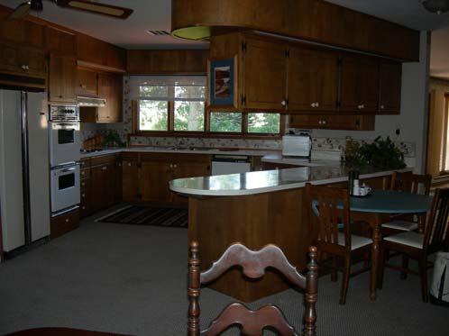
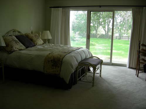
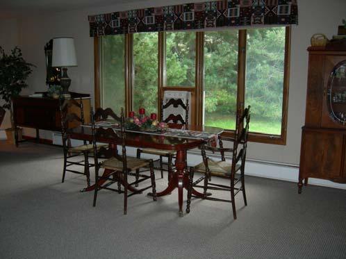
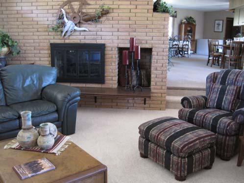
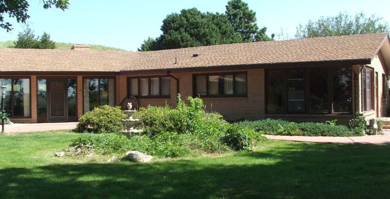
10 Cross Ranch Headquarters Site The Cross Ranch Headquarters Site located on the West Unit just off of Highway 20 and near Coffey Lake offers an exceptional set of improvements. The main house is a beautiful 3,500 square foot brick home complete with 4 bedrooms and 3 bathrooms. The unattached garage is 24 X26. There is a smaller second home for hired man, as well. Calving is facilitated with the fully equipped 42 X108 Morton calving barn and the 20 X60 calving shed. The headquarters also includes a 40 X75 machine shed, 26 X64 shop, 24 X30 storage shed and an older 30 X50 barn.
11

12 AGRI AFFILIATES Providing Services for Farm, Ranch & Recreational Properties The Contract When two people meet an agreement made, the terms of the deal the plans are laid. Each one gives their seal by the grip of their hand, on their word of honor they take their stand. These days there are contracts all written out, so there is nothing to dispute about. But if a person won t stand on their word understood, A piece of paper won t make it good. Shalah Contact: Mike Polk, Co-Listing Agent (308) or mike@agriaffiliates.com Or Sonny Maddux, Co-Listing Agent (308) or madduxlandbanc@yahoo.com Bruce Dodson, Loren Johnson, Jerry Weaver, Roger Luehrs, Dallas Dodson Co-Listed with Maddux Landbanc Realty, LLC Offered By: NORTH PLATTE OFFICE P.O. Box 1166 I-80 & US Hwy 83 North Platte, NE (308) Telecopier (308) Information contained herein was obtained from sources deemed reliable. We have no reason to doubt the accuracy, but we do not guarantee it. Prospective Buyers should verify all information, including items of income and expense.
Alamito Creek Preserve Ranches for Sale Marfa, Presidio County, Texas
 Alamito Creek Preserve Ranches for Sale Marfa, Presidio County, Texas James King, Agent Office 432 426.2024 Cell 432 386.2821 James@KingLandWater.com Alamito Creek Preserve Various size Ranch Properties,
Mule Shoe Bar South Ranch
 Mule Shoe Bar South Ranch All contiguous rangeland with sub irrigated range sites consisting of 11,555 total acres Mike Lashley Owner Broker Mike s Cell: 308-530-0134 Email: mike@lashleyland.com Property
Northwest FCS - Non-Producing Property Report Create Date: 10/30/2018
 Page 1 of 15 County: ADA 1 10 002N 001E NW4SW4 13 10016 MINERAL 40.00 0.5000000 20.00 2 10 002N 001E NW4 14 10017 MINERAL 160.00 0.5000000 80.00 3 09 003N 001E PART OF THE S2: LYING N OF THE RR R/W 18
Mule Shoe Bar Beck Ranch
 Mule Shoe Bar Beck Ranch All contiguous combination pivot irrigated and rangeland consisting of 7,908 acres Property Highlights List Price $4,927,263 Location The historic Mule Shoe Bar Ranches are located
CAMARGO RANCH, llc. CRAIG BUFORD BufordResources.com
 CAMARGO RANCH, llc 2897 +/- acre Wheat & Cattle Farm Mangum, greer county, oklahoma CRAIG BUFORD 405-833-9499 BufordResources.com 4101 Perimeter Center Dr., Suite 107 Oklahoma City, OK 73112 405.833.9499
carpenter real estate presents:
 carpenter real estate presents: this is one of the best trophy class desert mule deer, aoudad sheep and bird hunting ranches in west texas. Elevations range from 4,400 feet to 5,180 feet. Ideal habitat
Quebec Ranch 12,500Acres Presidio County, Texas
 Quebec Ranch 12,500Acres Presidio County, Texas James King, Agent Office 432.426.2024 Cell 432.386.2821 James@KingLandWater.com Quebec Ranch 12,500 Acres Marfa, Presidio County, Texas James King, Agent
Alamito Waters Ranch 80 acres, Presidio County, Texas James King, Agent Office Cell
 Alamito Waters Ranch 80 acres, Presidio County, Texas James King, Agent Office 432-426-2024 Cell 432-386-2821 James@KingLandWater.com King Land & Water LLC P.O. Box 109, 600 State Street, Fort Davis, TX
Aplomado Flats Ranch acres, Brewster County, Texas
 Aplomado Flats Ranch 2701.7 acres, Brewster County, Texas James King, Agent Office 432-426-2024 Cell 432-386-2821 James@KingLandWater.com King Land & Water LLC P.O. Box 109, 600 State Street, Fort Davis,
Quebec Ranch 12,500 acres, Presidio County
 Quebec Ranch 12,500 acres, Presidio County Quebec Ranch 12,500 Acres Marfa, Presidio County, exas James King, Agent Office 432.426.2024 James@KingLandWater.com Location he Quebec Ranch is located 25 miles
South Alamito Creek Ranch
 South Alamito Creek Ranch 1500 acres, Presidio County, Texas James King, Agent Office 432-426-2024 Cell 432-386-2821 James@KingLandWater.com King Land & Water LLC P.O. Box 109, 600 State Street, Fort Davis,
Coyote Creek Apache County, Arizona
 Coyote Creek Apache County, Arizona Listed for sale exclusively by: Traegen Knight Headquarters West Ltd. PO BOX 1980 St. Johns, AZ 85936 Phone: (928) 524-3740, Fax: (928) 563-7004, Cell: (602) 228-3494
Fall River Valley Irrigated Farmland
 AG-LAND Investment Brokers 275 Sale Lane Red Bluff, CA 96080 530-529-4400 Fax 530-527-5042 Fall River Valley Irrigated Farmland Tehama McArthur, County, California 2015 well, 16 inch casing, 150 HP, 2,000
BROWN COUNTY FARMLAND AUCTION
 BROWN COUNTY FARMLAND AUCTION CROP - PASTURE - HUNTING - INVESTMENT 62 Acres +/- TUESDAY, NOVEMBER, 1 :30am Auction Location: The DEC (Dakota Event Center) - Lamont St. - Aberdeen, SD 5401 Mercier & Ravina
Upper Owyhee Watershed Assessment
 * Owyhee Watershed Council and Scientific Ecological Services The upper Owyhee subbasin is located in parts of three states: the southeastern corner of Oregon, the southwestern corner of Idaho, and north
Old Thomasson Range, Chico, CA
 AG-LAND INVESTMENT BROKERS 275 Sale Lane, Suite 2 / P. O. Box 896 Red Bluff, CA 96080 530.529.4400 office / 530.527.5042 fax Old Thomasson Range, Chico, CA Property: Approximately 5,270 acres bordered
[LLNVS01000 L EA0000 LVRCF A 18X MO# ] Notice of Temporary Closure of Public Land in Clark County, Nevada
![[LLNVS01000 L EA0000 LVRCF A 18X MO# ] Notice of Temporary Closure of Public Land in Clark County, Nevada](/thumbs/96/127731372.jpg "[LLNVS01000 L EA0000 LVRCF A 18X MO# ] Notice of Temporary Closure of Public Land in Clark County, Nevada") This document is scheduled to be published in the Federal Register on 03/07/2019 and available online at https://federalregister.gov/d/2019-04135, and on govinfo.gov 4310-HC DEPARTMENT OF THE INTERIOR
This document is scheduled to be published in the Federal Register on 03/07/2019 and available online at https://federalregister.gov/d/2019-04135, and on govinfo.gov 4310-HC DEPARTMENT OF THE INTERIOR
Kennedy Ranch /- acres, Presidio County, Texas
 Kennedy Ranch 3187 +/- acres, Presidio County, Texas Kennedy Ranch 3,187 Acres Casa Piedra Road Marfa, Presidio County, Texas James King, Agent Office 432 426.2024 James@KingLandWater.com Location The
CHAPTER 10. TORNADOES AND WINDSTORMS
 CHAPTER 10. TORNADOES AND WINDSTORMS Wyoming, lying just west of tornado alley, is fortunate to experience less frequent and intense tornadoes than its neighboring states to the east. However, tornadoes
Review of Riparian Function Riparian Management Riparian Monitoring
 Review of Riparian Function Riparian Management Riparian Monitoring Water Shed Water Catchment Water catching creek Water shedding creek Properly functioning riparian area Properly Functioning Riparian
Cripps Ranch 76+/- Acres Orchard Development Opportunity Dixon, CA. Presented By:
 Cripps Ranch 76+/- Acres Orchard Development Opportunity Dixon, CA Presented By: Cripps Ranch 76+/- Acres Orchard Development Opportunity Dixon, CA Location: This property is located at 5663 Dally Road
I-94 COMMERCIAL LAND ±30.44 ACRES TH ST Eau Galle, WI 54747
 PROPERTY HIGHLIGHTS + + Located off I-94 and Hwy 63 Interchange 2,900 VPD + + Baldwin-Woodville Area School District + + Zoning: Commercial, Rural Residential + + 40 miles to St. Paul + + 25 miles to Menomonie,
Sacramento River Farmland Anderson, California
 AG-LAND INVESTMENT BROKERS 275 Sale Lane / P. O. Box 896 Red Bluff, CA 96080 530.529.4400 office / 530.527.5042 fax Sacramento River Farmland Anderson, California Property: 45 +/- acres of farmland with
CITY OF PAPILLION PLANNING COMMISSION STAFF REPORT MAY 27, 2015 AGENDA 2015 ANNEXATION MISC
 PLANNING COMMISSION STAFF REPORT MAY 27, 2015 AGENDA 2015 ANNEXATION MISC-15-0005 I. GENERAL INFORMATION A. APPLICANT: City of Papillion 122 East Third St. Papillion, NE 68046 B. LEGAL DESCRIPTION: See
Dolores Public Lands Office Highway 184 Dolores, CO Ph (970) Fax (970)
 Fax (970)") USDA Forest Service San Juan National Forest Mancos/Dolores Ranger District http://www.fs.fed.us/r2/sanjuan Dolores Public Lands Office 29211 Highway 184 Dolores, CO 81323 Ph (970) 882-7296 Fax (970) 882-6841
USDA Forest Service San Juan National Forest Mancos/Dolores Ranger District http://www.fs.fed.us/r2/sanjuan Dolores Public Lands Office 29211 Highway 184 Dolores, CO 81323 Ph (970) 882-7296 Fax (970) 882-6841
Kennedy Ranch 3,187 Acres, near Marfa, Presidio County Texas
 Kennedy Ranch 3,187 Acres, near Marfa, Presidio Texas James King, Agent Office 432-426-2024 Cell 432-386-2821 James@KingLandWater.com King Land & Water LLC P.O. Box 109, 600 State Street, Fort Davis, TX
Description DESCRIPTION
 DESCRIPTION The location of the Upper James Watershed is located in northeastern South Dakota as well as southeastern North Dakota. It includes the following counties located in North Dakota Barnes, Dickey,
Comanche Trail Ranch 48,404 Acres, Pecos County, Texas James King, Agent Office Cell
 Comanche rail Ranch 48,404 Acres, Pecos County, exas James King, Agent Office 432-426-2024 Cell 432-386-2821 James@KingLandWater.com King Land & Water LLC P.O. Box 109, 600 State Street, Fort Davis, X
FOR 274 Assignment 3 [20 points] This assignment should be completed and handed at the start of lecture on Friday 16th September.
![FOR 274 Assignment 3 [20 points] This assignment should be completed and handed at the start of lecture on Friday 16th September.](/thumbs/90/101578770.jpg "FOR 274 Assignment 3 [20 points] This assignment should be completed and handed at the start of lecture on Friday 16th September.") FOR 274 Assignment 3 [20 points] Name: This assignment should be completed and handed at the start of lecture on Friday 16th September. 1. Convert the following bearings to azimuths: a. N35 W b. S22 E
FOR 274 Assignment 3 [20 points] Name: This assignment should be completed and handed at the start of lecture on Friday 16th September. 1. Convert the following bearings to azimuths: a. N35 W b. S22 E
b. What is the length, width (ft), and direction of flow of Seafield Lake?
, and direction of flow of Seafield Lake?") FOR 274 Assignment 3 [50 points] Name: Section: This assignment should be completed and handed in to the assignment box in the Forest Resources office by noon on Monday 17th of September. Partial credit
FOR 274 Assignment 3 [50 points] Name: Section: This assignment should be completed and handed in to the assignment box in the Forest Resources office by noon on Monday 17th of September. Partial credit
2. PHYSICAL SETTING FINAL GROUNDWATER MANAGEMENT PLAN. 2.1 Topography. 2.2 Climate
 FINAL GROUNDWATER MANAGEMENT PLAN 2. PHYSICAL SETTING Lassen County is a topographically diverse area at the confluence of the Cascade Range, Modoc Plateau, Sierra Nevada and Basin and Range geologic provinces.
Fairfield Hill Road Winnsboro, South Carolina
 Fairfield Hill Road Winnsboro, South Carolina Tom Milliken +1 803 331 6999 tmilliken@naiavant.com Tombo Milliken +1 803 206 8384 tombo.milliken@naiavant.com THE INFORMATION CONTAINED HEREIN HAS BEEN GIVEN
Producing Chandler Walnut Orchard
 AG-LAND Investment Brokers 275 Sale Lane Red Bluff, CA 96080 530-529-4400 Fax 530-527-5042 Producing Chandler Walnut Orchard West Sacramento Avenue - Chico, CA AG-LAND INVESTMENT BROKERS 275 Sale Lane
VIKING INSPECTION PROPERTY 4921 U.S. Hwy. 85, Williston, ND 58801
 SALE PRICE: $799,000 LOT SIZE: +/-2.49 Acres BUILDING SIZE: +/-3,800 SF DRIVE-IN DOORS 2 CEILING HEIGHT: 16' YEAR BUILT: 2007 ZONING: Commercial PROPERTY OVERVIEW Highly visible, hard-to-find small shop/office/apartment
DELTA COUNTY. CASE NO. 2017CW43
 IN THE DISTRICT COURT IN AND FOR WATER DIVISION NO. 4 STATE OF COLORADO TO: ALL PERSONS INTERESTED IN WATER APPLICATIONS IN SAID WATER DIVISION NO. 4 Pursuant to C.R.S. 37-92-302, as amended, you are notified
REQUEST FOR PROPOSALS CLOSING DATE:
 Request for Proposals 110 Westlake Drive City of West Lake Hills 110 Westlake Drive REQUEST FOR PROPOSALS CLOSING DATE: Tuesday, October 23, 2018 City of West Lake Hills Request for Proposals 1 I. INTRODUCTION
Budgets: 2007 planning budgets
 R5 Ranch Budgets: 2007 planning budgets Anywhere UR, Eastern Oregon File: Ray & Reba Barlow User: Bart Eleveld FINPACK Printed 10/30/2008 3:33:50 PM Crop Budget No. 1 2 3 Crop Wheat, Cash Winter Barley,
3.3 CLIMATE, GEOLOGY, TOPOGRAPHY, AND SOILS CLIMATE GEOLOGY TOPOGRAPHY
 3.3 CLIMATE, GEOLOGY, TOPOGRAPHY, AND SOILS This section describes the climate, geology, topography, and soil resource characteristics of the Yolo Bypass Wildlife Area (Wildlife Area). Agricultural soil
Economic, Productive & Financial Performance Of Alberta Cow/Calf Operations
 Benchmarks for Cattlemen Economics & Competitiveness Economic, Productive & Financial Performance Of Cow/Calf Operations Moist Mixed land Production Year - 1999 Nov-03 Foreword This AgriProfit$ & Returns
NIDIS Intermountain West Drought Early Warning System April 18, 2017
 1 of 11 4/18/2017 3:42 PM Precipitation NIDIS Intermountain West Drought Early Warning System April 18, 2017 The images above use daily precipitation statistics from NWS COOP, CoCoRaHS, and CoAgMet stations.
Wind River Indian Reservation and Surrounding Area Climate and Drought Summary
 Northern Arapaho Tribe Wind River Indian Reservation and Surrounding Area Climate and Drought Summary Summer Events & Fall Outlook 2015 Summer Was Near, Precipitation Was Highly Variable Across The Region
For Sale at $437,500.00
 We are pleased to present Carlson Farm 72.43 ± Acres Garden City Township, Blue Earth County For Sale at $437,500.00 Listing Agent: Darrell Hylen, ALC Office: 507-345-LAND (5263) Toll Free: 800-730-LAND
Chittenden Road Prune Orchard Corning, California
 AG-LAND INVESTMENT BROKERS 275 Sale Lane / P. O. Box 896 Red Bluff, CA 96080 530.529.4400 office / 530.527.5042 fax Chittenden Road Prune Orchard Corning, California Property: 40.00 acres planted to producing
March 31, Dear Ms. Shreve:
 March 31, 2005 Ms. Kathy Shreve Wyoming Department of Environmental Quality NPDES Permit Section 122 W. 25 th Street Herschler Building 4W Cheyenne, WY 82002 Subject: Response to Complete but Technically
Chapter 3. Description of the Study Area. Karl Taboga, James Stafford and Paul Taucher 3-19
 Chapter 3 Description of the Study Area Karl Taboga, James Stafford and Paul Taucher 3-19 T his study examines groundwater resources that underlie the Bear River drainage basin in Wyoming as well as areas
APPLICATION FOR CONDITIONAL ABSOLUTE WATER STORAGE RIGHT
 District Court, Water Division, Colorado Court Address: CONCERNING THE APPLICATION FOR WATER RIGHTS OF Applicant: In the River or its Tributaries In COUNTY Attorney or Party Without Attorney (Name and
FOR SALE +/- 419 ACRES ¼ Mile South of Alliance Airport
 FOR SALE +/- 419 ACRES ¼ Mile South of Alliance Airport Alliance Airport Subject property +/- 419 AC Pat McDowell +1 817 334 8106 pat.mcdowell@am.jll.com JLL 201 Main Street, Suite 1440 Fort Worth, TX
Crow River Plaza - Retail Development South Diamond Lake Rd. Rogers, MN FOR LEASE 1,024 SF Retail Space. Lease Rate: $16.
 FEATURES: - Available in Rogers, MN Lease Rate: $16.00 / psf NNN - Excellent location with freeway signage on I-94! - Near large retailers such as Target, Kohls, & Applebees. Taxes $3.65 / psf Cam $3.20
NWS FORM E-5 U.S. DEPARTMENT OF COMMERCE I HYDRO SERVICE AREA NOAA, NATIONAL WEATHER SERVICE I Indianapolis, IN MONTHLY REPORT
 NWS FORM E-5 U.S. DEPARTMENT OF COMMERCE I HYDRO SERVICE AREA NOAA, NATIONAL WEATHER SERVICE I Indianapolis, IN. 1-------------------- MONTHLY REPORT OF RIVER AND FLOOD CONDITIONSI REPORT FOR I November
Simple Solutions Social Studies Level 2. Level 2. Social Studies. Help Pages
 Level 2 Social Studies 147 148 adobe houses with bricks made of clay and straw ancestor a family member who lived before us appoint choose; leaders can appoint others barter trading one thing for another
Economic, Productive & Financial Performance Of Alberta Cow/Calf Operations
 Benchmarks for Alberta Cattlemen Economics & Competitiveness Economic, Productive & Financial Performance Of Alberta Cow/Calf Operations Comparing: Southern Alberta Total, Southern Alberta Low Cost, and
Crow River Plaza - Retail Development South Diamond Lake Rd. Rogers, MN FOR LEASE 2,066 SF Retail Space. Lease Rate: $16.
 FEATURES: - 2,066 SF End Cap Retail Space Available in Rogers, MN - Excellent location with freeway signage on I-94! - Near large retailers such as Target, Kohls, & Applebees. - Convenient location off
REDWOOD VALLEY SUBAREA
 Independent Science Review Panel Conceptual Model of Watershed Hydrology, Surface Water and Groundwater Interactions and Stream Ecology for the Russian River Watershed Appendices A-1 APPENDIX A A-2 REDWOOD
Name of Applicant Mailing Address address Telephone Number
 District Court, Water Division, Colorado Court Address: CONCERNING THE APPLICATION FOR WATER RIGHTS OF Applicant: In the River or its Tributaries In COUNTY Attorney or Party Without Attorney (Name and
MILLS COUNTY, IOWA FARMLAND FOR SALE PRICE REDUCED
 MILLS COUNTY, IOWA FARMLAND FOR SALE PRICE REDUCED Owners: Riverdale Farm Corp. Acres: 302.59 Legal Description: Location: Description: See Attached From I-29/Highway 370 exit, 1 ¾ Miles west on Highway
The Climate of Payne County
 The Climate of Payne County Payne County is part of the Central Great Plains in the west, encompassing some of the best agricultural land in Oklahoma. Payne County is also part of the Crosstimbers in the
The Climate of Texas County
 The Climate of Texas County Texas County is part of the Western High Plains in the north and west and the Southwestern Tablelands in the east. The Western High Plains are characterized by abundant cropland
Technical Memorandum. City of Salem, Stormwater Management Design Standards. Project No:
 Technical Memorandum 6500 SW Macadam Avenue, Suite 200 Portland, Oregon, 97239 Tel: 503-244-7005 Fax: 503-244-9095 Prepared for: Project Title: City of Salem, Oregon City of Salem, Stormwater Management
CASE NO. 2017CW9 (REF NO. 03CW68).
.") IN THE DISTRICT COURT IN AND FOR WATER DIVISION NO. 4 STATE OF COLORADO TO: ALL PERSONS INTERESTED IN WATER APPLICATIONS IN SAID WATER DIVISION NO. 4 Pursuant to C.R.S. 37-92-302, as amended, you are notified
IN THE DISTRICT COURT IN AND FOR WATER DIVISION NO. 4 STATE OF COLORADO TO: ALL PERSONS INTERESTED IN WATER APPLICATIONS IN SAID WATER DIVISION NO. 4 Pursuant to C.R.S. 37-92-302, as amended, you are notified
Wessinger Road, Hilton Area Chapin, South Carolina
 779' For Sale 191' 182' 171'! A! B 858' 4.84 ± Acres 788' 4.25 ± Acres 60' 241' 321' Wessinger Road, Hilton Area Chapin, South Carolina 357' 115' 51' 294'! C! D 6.51 ± Acres 902' 8.35 ± Acres 246' 60'
APPENDIX V VALLEYWIDE REPORT
 APPENDIX V VALLEYWIDE REPORT Page Intentionally Left Blank 1.2 San Joaquin Valley Profile Geography The San Joaquin Valley is the southern portion of the Great Central Valley of California (Exhibit 1-1).
The Climate of Oregon Climate Zone 7 South Central Area
 /65 '5 Unbound issue tqc;. 9 11 Does not circulate (i.13 Special Report 919 May The Climate of Oregon Climate Zone 7 Property of OREGON STATE UNIVERSITY Library Serials Corvallis, OR 9 733 1-4503 Agricultural
GY 301: Geomorphology Lab 3: Introduction to Topographic Maps; Coastal Geomorphology
 Name: Raw score: /65 Percentage: /100% GY 301: Geomorphology Your Task: Today s lab is your first opportunity to closely examine topographic maps. You will be asked to answer various questions about map
Written by Vowery Dodd Carlile and Traci Burnett Illustrated by Karen Birchak
 Written by Vowery Dodd Carlile and Traci Burnett Illustrated by Karen Birchak Table of Contents INTRODUCTION...5 TO THE TEACHER...6 STORIES ABOUT TEXAS: Background, Vocabulary Activities, Discussion Questions,
Natural Texas. Regions and Climates
 Natural Texas Regions and Climates Two Kinds: Physical geography Climate, vegetation, rivers, lakes, oceans, plateaus, plains, and mountain ranges Human geography Economic activities How we earn a living
TO: ALL PERSONS INTERESTED IN WATER APPLICATIONS IN SAID WATER DIVISION NO. 7
 DISTRICT COURT, WATER DIVISION 7, COLORADO WATER RESUME TO: ALL PERSONS INTERESTED IN WATER APPLICATIONS IN SAID WATER DIVISION NO. 7 Pursuant to C.R.S. 37-92-302, you are notified that the following is
Summary of Legal Descriptions
 Perimeter Descriptions Bounds Descriptions - perimeter descriptions without a direction of travel. Metes Descriptions - perimeter descriptions with a direction of travel described by a series of measurements.
CITY OF FORT COLLINS JULY 2017 MONTHLY REPORT
 CITY OF FORT COLLINS JULY 2017 MONTHLY REPORT AUGUST 3RD, 2017 West Nile Virus Risk Contact VDCI: Northern Colorado Operations Manager Broox Boze, Ph.D. Phone (970)962-2582 Fax (970)962-2584 E-Mail: bboze@
Changes in Texas Ecoregions Copy the questions and answers
 Changes in Texas Ecoregions Copy the questions and answers 1. What are some kinds of damage that hurricanes cause? Roads and bridges might be washed away. Trees and power lines can be knocked down. Area
Marfa House and Ranch Property 2,400 acres with premier residence, Marfa, Presidio County, Texas
 Marfa House and Ranch Property 2,400 acres with premier residence, Marfa, Presidio County, Texas James King, Agent Office 432 426.2024 Cell 432 386.2821 James@KingLandWater.com Marfa House and Ranch Property
Roger Andy Gaines, Research Civil Engineer, PhD, P.E.
 Roger Andy Gaines, Research Civil Engineer, PhD, P.E. Research Civil Engineer/Regional Technical Specialist Memphis District August 24, 2010 Objectives Where we have been (recap of situation and what s
Prairie Wings One of America s Trophy Waterfowl Hunting Properties.
 Print by artist: David Drinkard offered for sale Prairie Wings One of America s Trophy Waterfowl Hunting Properties. 1,650 (+/-) total acres Jefferson County, Arkansas represented by DISCLOSURE STATEMENT
For Sale - 56 Acre Sandstone Quarry State Route 511, Oberlin/Kipton, OH 44075
 14647 State Route 511, Oberlin/Kipton, OH 44075 56 ACRES Vermilion Rd Gifford Rd Haigh Rd 44 Summary The Kipton sandstone quarry is included in 56 acre tract owned by Terry A. Johnson, of Huron, Ohio.
Climate change in the U.S. Northeast
 Climate change in the U.S. Northeast By U.S. Environmental Protection Agency, adapted by Newsela staff on 04.10.17 Word Count 1,109 Killington Ski Resort is located in Vermont. As temperatures increase
APPLICATION TO AMEND THE FUTURE LAND USE MAP (FLUM) SMALL SCALE
 SMALL SCALE") DEPARTMENT OF DEVELOPMENT & PLANNING 825 Ohio Avenue - Lynn Haven, FL 32444 (850) 265-2961 - (850) 265-3478 APPLICATION TO AMEND THE FUTURE LAND USE MAP (FLUM) SMALL SCALE Deadline to submit is 30 days
DEPARTMENT OF DEVELOPMENT & PLANNING 825 Ohio Avenue - Lynn Haven, FL 32444 (850) 265-2961 - (850) 265-3478 APPLICATION TO AMEND THE FUTURE LAND USE MAP (FLUM) SMALL SCALE Deadline to submit is 30 days
CITY OF PORTLAND, TEXAS SERVICE PLAN FOR ANNEXATION AREA
 CITY OF PORTLAND, TEXAS SERVICE PLAN FOR ANNEXATION AREA Location and Acreage Approximately 1,863 acres of land in San Patricio County, located in the ETJ northwest of the existing City Limits. Metes and
Learning Objectives: I can identify and interpret river flows and directions.
 Learning Objectives: I can identify and interpret river flows and directions. Bellringer Review: Check for Understanding Questions: 1 2 What Are The Key Parts Of A River s Anatomy? In your data notebooks
Highland Lake Bathymetric Survey
 Highland Lake Bathymetric Survey Final Report, Prepared For: The Town of Highland Lake 612 Lakeshore Drive Oneonta, AL 35121 Prepared By: Tetra Tech 2110 Powers Ferry Road SE Suite 202 Atlanta, GA 30339
Following the Civil War, many Americans and Europeans continued to move into the WEST
 1860-1900 Following the Civil War, many Americans and Europeans continued to move into the WEST as far as the eye can see millions of acres of treeless grassland. Between the Mississippi River and the
Information Paper. Kansas City District. Missouri River Fish and Wildlife Mitigation Project Jim and Olivia Hare Wildlife Area, MO
 City District Information Paper River Fish and Wildlife Mitigation Project Jim and Olivia Hare Wildlife Area, MO Riverine habitat created in 2004/2005 by modifying existing river structures along the banks,
Central North Dakota Shallow Gas Potential A Historical Perspective
 Central Shallow Gas Potential A Historical Perspective David W. Fischer Fischer Oil and Gas, Inc. Fred J. Anderson Department CURRENT ND ACTIVITIES ONLINE BIBLIOGRAPHY OF SHALLOW GAS REFERENCES ONLINE
COLOR CLAIMS, INC. 637 S. 400 East, Cedar City, UT
 COLOR CLAIMS, INC. 637 S. 400 East, Cedar City, UT 84720 435-586-5072 435-590-5747 waynea1@yahoo.com Date: May 30, 2012 I, Craig Parkinson, Geologist, hereby state that the valuation report issued for
SLOSH New Orleans Basin 2012 Update
 SLOSH New Orleans Basin 2012 Update Michael Koziara Science and Operations Officer National Weather Service Slidell, LA The Basics What is storm surge? What is SLOSH? Details Assumptions Inundation = Storm
Through their research, geographers gather a great deal of data about Canada.
 Ecozones What is an Ecozone? Through their research, geographers gather a great deal of data about Canada. To make sense of this information, they often organize and group areas with similar features.
POPULATION TRENDS FOR TULARE PSEUDOBAHIA AND STRIPED ADOBE LILY
 POPULATION TRENDS FOR TULARE PSEUDOBAHIA AND STRIPED ADOBE LILY Kern County has more endangered, threatened and rare plant species than most states. The geography and environmental conditions in the county
Climate. Annual Temperature (Last 30 Years) January Temperature. July Temperature. Average Precipitation (Last 30 Years)
 January Temperature. July Temperature. Average Precipitation (Last 30 Years)") Climate Annual Temperature (Last 30 Years) Average Annual High Temp. (F)70, (C)21 Average Annual Low Temp. (F)43, (C)6 January Temperature Average January High Temp. (F)48, (C)9 Average January Low Temp.
Climate Annual Temperature (Last 30 Years) Average Annual High Temp. (F)70, (C)21 Average Annual Low Temp. (F)43, (C)6 January Temperature Average January High Temp. (F)48, (C)9 Average January Low Temp.
Erosion Information Paper Eagle City and Eagle Village, Alaska Current as of January 21, 2008
 U.S. Army Corps of Engineers ALASKA BASELINE EROSION ASSESSMENT Erosion Information Paper Eagle City and Eagle Village, Alaska Current as of January 21, 2008 Community Information The City of Eagle, population
Carrick Road $798,000
 1955-2020 Carrick Road 165.76± acres Fayette/Scott Counties $798,000 Offered Exclusively By: Zach Davis Principal Broker +1.859.576.8195 www.kirkfarms.com zach@kirkfarms.com Measuring an appx. 165+/- acres,
V E R M E J O P A R K R A N C H
 V E R M E J O P A R K R A N C H ABOUT TED TURNER EXPEDITIONS Ted Turner Expeditions is rooted in two million acres of wild, private North American landscape acquired by Ted Turner as a pioneering investment
Lake Sedimentation Survey of Siloam Springs State Park Lake, Adams County, Illinois
 Contract Report 567 Lake Sedimentation Survey of Siloam Springs State Park Lake, Adams County, Illinois by Richard L. Allgire Office of Sediment & Wetland Studies Prepared for the Illinois Department of
FIND PLACES ON GLOBES USING LATITUDE
 GLOBES, MAPS & GRAPHS FIND PLACES ON GLOBES USING LATITUDE AND LONGITUDE LINES FIND PLACES ON MAPS USING A GRID SYSTEM NAME SEVERAL TYPES OF MAP PROJECTIONS AND EXPLAIN THEIR BENEFITS AND SHORTCOMINGS
CALIFORNIA AGRICULTURAL PR OPERTIES, IN C. GALE RANCH
 CALIFORNIA AGRICULTURAL PR OPERTIES, IN C. GALE RANCH LOCATION: The Ranch is located 6 Yi miles west of the City of Davis on the northwest corner of County Roads 29A and 92E in Yolo County. SIZE: 368.64
U.S. WIND, SCS, FLOOD, WINTER WEATHER
 U.S. WIND, SCS, FLOOD, WINTER WEATHER An unusually strong winter storm crossing the Central Plains continues to bring winter weather, strong winds, heavy precipitation and severe thunderstorms to areas
The Climate of Murray County
 The Climate of Murray County Murray County is part of the Crosstimbers. This region is a transition between prairies and the mountains of southeastern Oklahoma. Average annual precipitation ranges from
Wyoming State Operations Center
 Wyoming State Operations Center Updated Situation Report, Bordeaux Tornado site 14: 36 hrs 8 June 2012 Wyoming Office of Homeland Security (WOHS) arrived at the incident command post at the corner of Olson
U.S. ARMY CORPS OF ENGINEERS
 CORPS FACTS Regulating Mississippi River Navigation Pools U.S. ARMY CORPS OF ENGINEERS BUILDING STRONG Historical Background Federal improvements in the interest of navigation on the Mississippi River
Weather History on the Bishop Paiute Reservation
 Weather History on the Bishop Paiute Reservation -211 For additional information contact Toni Richards, Air Quality Specialist 76 873 784 toni.richards@bishoppaiute.org Updated 2//214 3:14 PM Weather History
Wind River Indian Reservation and Surrounding Area Climate and Drought Summary
 Northern Arapaho Tribe Wind River Indian Reservation and Surrounding Area Climate and Drought Summary Spring Events & Summer Outlook 2015 Spring Was Warm And Very Wet Across The Region The spring season
TRINITY COUNTY. Board Item Request Form Phone
 County Contract No. Department Board of Supervisors TRINITY COUNTY 6.01 Board Item Request Form 2014-08-12 Contact Judy Pflueger Phone 623-1217 Requested Agenda Location County Matters Requested Board
MATHEWS FARM TUNICA MISSISSIPPI 1130 ACRES (+/ ) TUNICA AND DESOTO COUNTY FOR SALE. List Price $6,100,000.
 TUNICA AND DESOTO COUNTY FOR SALE. List Price $6,100,000.") MATHEWS FARM TUNICA MISSISSIPPI 1130 ACRES (+/ ) TUNICA AND DESOTO COUNTY FOR SALE List Price $6,100,000. FARM ACREAGE BREAKDOWN: Map Acres FSA Crop Acres Shop, bins, turn rows, and ditches Tract 1 Main
MATHEWS FARM TUNICA MISSISSIPPI 1130 ACRES (+/ ) TUNICA AND DESOTO COUNTY FOR SALE List Price $6,100,000. FARM ACREAGE BREAKDOWN: Map Acres FSA Crop Acres Shop, bins, turn rows, and ditches Tract 1 Main