Grant Opportunity Monitoring Bi-State Sage-grouse Populations in Nevada
|
|
|
- Constance McCarthy
- 5 years ago
- Views:
Transcription
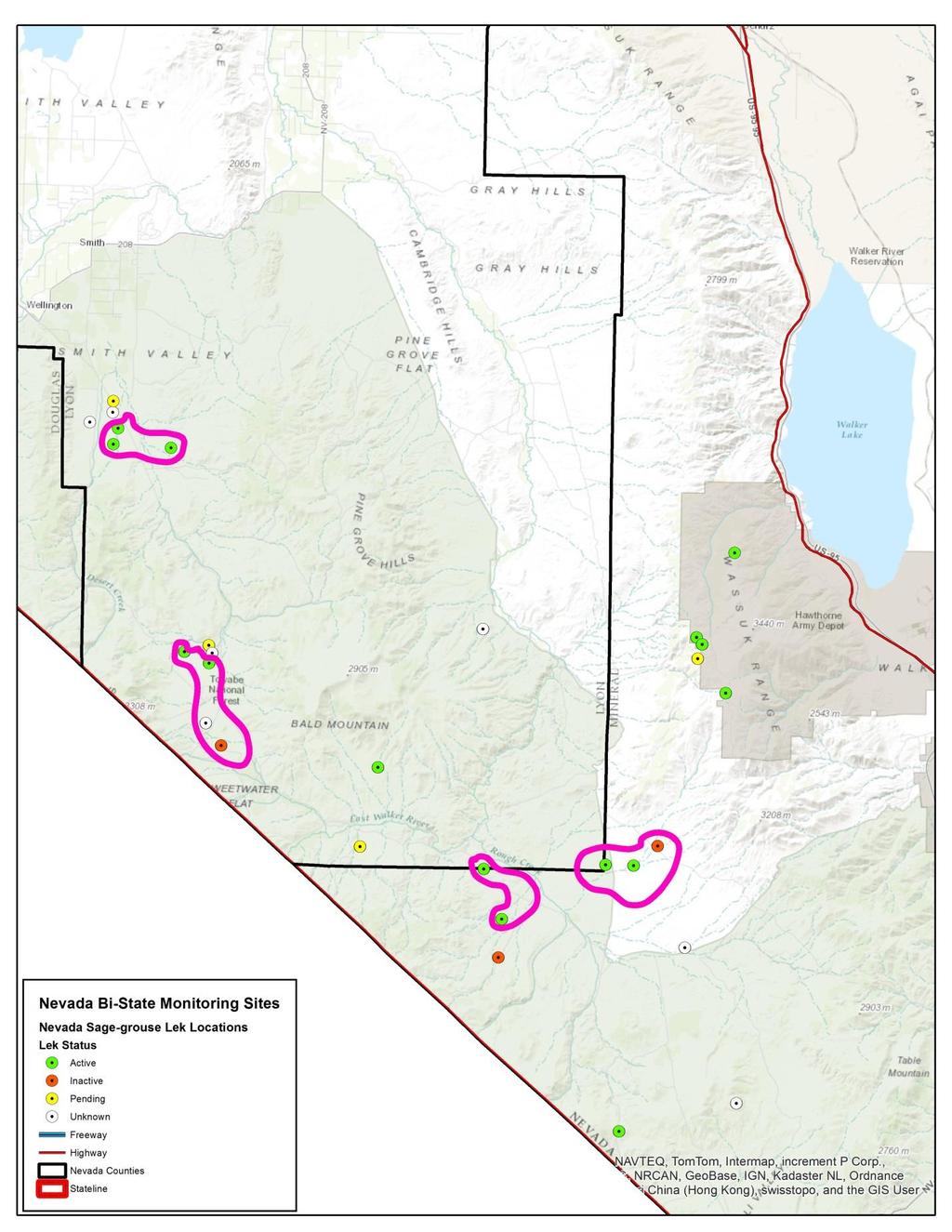
1 Grant Opportunity Monitoring Bi-State Sage-grouse Populations in Nevada Proposals are due no later than November 13, Grant proposal and any questions should be directed to: Shawn sepsinosa@ndow.org. The Nevada Department of Wildlife (NDOW) is committed to monitoring populations of Greater Sage-grouse (hereafter referred to as sage-grouse ) within the Nevada portion of the Bi-State Distinct Population Segment residing in southwestern Nevada along the border with California. Initially, monitoring will be conducted within the Desert Creek and Mount Grant Population Management Units (PMUs) to determine whether or not certain management actions and habitat improvement projects are effective at conserving sage-grouse within this area. These management actions and habitat improvement projects are outlined in the Bi-State Action Plan and the Greater sage-grouse Bi-State Distinct Population Segment Forest Plan Amendment Record of Decision (2015). It is important for NDOW to maintain this commitment to demonstrate effectiveness and adaptive management principles to the U.S. Fish and Wildlife Service, which found the Bi-State Sage-grouse not warranted for listing as a threatened or endangered species in April of Grant Application Instructions Please refer to scope of work below for details regarding this research project. Proposals should include the following at a minimum: Demonstrate qualifications to conduct tasks identified within the scope of work; Identification of the project manager and any supporting staff along with a brief description of their qualifications; A proposed cost estimate with detail to include: salary, travel, material costs and other anticipated expenses; A schedule of activities; Submission of the draft report in digital form Grant Eligibility (must meet all the following criteria) Must be a Government Agency or Academic Institution (University) with offices located in either Nevada or California; Specific experience working with Greater Sage-grouse within the Great Basin and measuring demographic parameters and habitat selection of sage-grouse; Scope of Work Sage-grouse Monitoring Capture and radio mark (utilizing GPS satellite transmitters and VHF Transmitters) up to 40 female sage-grouse initially (10 GPS satellite transmitters and 30 VHF transmitters) across the two study areas and maintain that approximate sample size over the course of the 3-year study; Capture and band any male sage-grouse encountered during trapping efforts; Periodically download and categorize data obtained from GPS satellite transmitters; Track VHF marked individual birds by ground or aircraft 2 3 times per week during nesting period; Determine nest initiation dates of each female grouse; Identify movement patterns during the nesting season; Determine nest fate of each female grouse and estimate daily nest survival probabilities; Estimate the effects of environmental characteristics on nest survival rates;
2 Calculate kernel home-ranges of female grouse during the nesting season; Track individual birds by ground or aircraft 2 3 times per week during brooding period; Conduct brood counts during day and night (spotlights) every 10-d interval through the brood-rearing period to document brood success. Broods with no chicks will be scored unsuccessful and confirmed within 48-hours; Calculate 10-day interval brood survival rate; Identify patterns in sexual segregation during the fall months using radio telemetry relocations; Identify late-fall feeding area for congregated broods; Estimate differences between male and female (with broods) departure dates to wintering areas; Use aircraft to identify wintering grounds; Calculate Brownian bridge movement path models to identify corridors between seasonal use areas; Calculate seasonal and annual survival rates and identify differences between sexes; Habitat Measurements and Analyses Within 48 hours of nest fate, measure multiple microhabitat characteristics at each nest site, including total shrub cover, sagebrush cover, perennial and annual grasses, perennial and annual forbs, vertical cover, and horizontal cover (measured at 5, 10, 25, 50, 100 m from nest site); Place four perpendicular transects centered at the nest and record the percent shrub cover for each meter along the transect at scales of 5, 10, 25 m; In addition, place two 20 X 50 cm Daubenmire plots along each transect and one at the nest center where percent cover is estimated and all plants are measured and keyed as annual or perennial; Use three methods, including Jones cover, board to estimate vertical and horizontal cover at each point of subplots and at the nest bowl; Conduct multiple measurements to quantify the amount of conifers within the nesting area (Monitor study site); Use maps of vegetation types derived from remote sensing data in a Geographical Information System (GIS) to measure habitat characteristics at larger spatial scales; Measure the habitat characteristics (field and GIS) at random points that are spatially dependent and independent from the nest site; Develop a cover class layer of conifers using 1-m resolution NAIP and NDVI data (Monitor study site); Conduct multi-scale habitat selection analysis using random and used points; Estimate the effects of grouse age and body condition on nest survival rates; Conduct habitat measurements (field and GIS) at a subsample of brood locations during day and night and dependent random locations for each 10-day interval; Develop and compare brood survival models that include vegetation characteristics as covariates to identify the effects of vegetation factors; Location 1) Desert Creek Population Management Unit sage-grouse use within the Nevada portion of this PMU is mainly concentrated around the terminus of Desert Creek proper (near State Highway 338) and Sweetwater Flat south of Wellington, Nevada. Late brood rearing habitat is centered on the Desert Creek Ranch and the Sweetwater Ranch;
3 however, relatively little is known regarding winter habitat use, or use of high elevation habitats within the Sweetwater Mountains or the Pine Grove Hills. 2) Mount Grant Population Management Unit Use of this PMU is relatively dispersed. Suitable low elevation habitats are located from Nine-mile Flat through China Camp and areas along the East Fork of the Walker River where it enters Nevada. Upper elevation habitat exists in the Wassuk Range near Mount Grant and in the Bodie Hills near Mount Hicks, Aurora Peak and Beauty Peak in Nevada. See Map below. Contractor Furnished Property and Services The contractor shall furnish labor and certain equipment and supplies to perform all work as set forth in the specifications. Provide NDOW with nesting and brood-rearing (March August) telemetry data by November 30 th each year following the field season. Data should be reported in an excel spreadsheet with the locations (Universal Transverse Mercator [UTM] preferred using North American Datum (NAD) 83 and latitude and longitude), date, sex, season (breeding, brood-rearing, fall, and winter). Provide NDOW with fall and winter (Aug March) telemetry data by May 1 st each year following flights. Data should be reported in an excel spreadsheet with the locations (UTM preferred using NAD 83 datum and latitude and longitude), date, sex, season (breeding, brood-rearing, fall, and winter). Provide NDOW with monthly progress reports for April, May, June and July summarizing the following: o Movement data (i.e. PMU connectivity, migration routes, landscape level movement drivers, movement distances from leks to nests, if Ruby Pipeline infrastructure is having a measurable effect on sage grouse habitat use, and presenting other noteworthy information) o Use areas (i.e. identification of new leks, confirmation of existing leks, nesting, brood-rearing, winter, and presenting other noteworthy information) o Habitat characteristics (i.e. nesting and brood-rearing site selection characteristics, determine what riparian/meadow characteristics sage-grouse are selecting for and against, and presenting other noteworthy information) o Population demographics (i.e. annual, seasonal, and daily survival estimates; nest and brood rearing success; average brood size, population growth estimates; presenting other noteworthy information.) o Other relevant information. Provide NDOW with an annual comprehensive report by December 31 st of each year summarizing: o o Movement data (i.e. PMU connectivity, migration routes, landscape level movement drivers, movement distances from leks to nests, and presenting other noteworthy information) Use areas (i.e. identification of new leks, confirmation of existing leks, nesting, brood-rearing, winter, and presenting other noteworthy information) o Habitat characteristics (i.e. nesting and brood-rearing site selection characteristics, determine what riparian/meadow characteristics sage-grouse are selecting for and against, and presenting other noteworthy information)
4 o Population demographics (i.e. annual, seasonal, and daily survival estimates; nest and brood rearing success; population growth estimates; presenting other noteworthy information.) o Other relevant information. Will submit data upon request. Random data request may occur on a limited basis. Data request may include but is not limited to the information discussed under subgrantee obligations and additional information. Any activities performed under this subgrant shall acknowledge the funding was provided through the Nevada Department of Wildlife s Upland Game Stamp program and the U.S. Fish and Wildlife Service s Wildlife Restoration federal aid funding. NDOW Furnished Property and Services NDOW will provide USGS with technical assistance and guidance throughout the project process; NDOW may provide personnel assistance with capture efforts in either of the two study site locations.
5
Grant Opportunity Greater Sage-grouse Monitoring within Nevada s Most Novel Habitats
 Grant Opportunity Greater Sage-grouse Monitoring within Nevada s Most Novel Habitats Proposals are due no later than September 8, 2017. Grant proposals and any questions should be directed to: Shawn Espinosa
Putative Canada Lynx (Lynx canadensis) Movements across I-70 in Colorado
 Movements across I-70 in Colorado") Putative Canada Lynx (Lynx canadensis) Movements across I-70 in Colorado INTRODUCTION March 8, 2012 Jake Ivan, Mammals Researcher Colorado Parks and Wildlife 317 W. Prospect Fort Collins, CO 80526 970-472-4310
Putative Canada Lynx (Lynx canadensis) Movements across I-70 in Colorado INTRODUCTION March 8, 2012 Jake Ivan, Mammals Researcher Colorado Parks and Wildlife 317 W. Prospect Fort Collins, CO 80526 970-472-4310
Minimum Standards for Wetland Delineations
 Minimum Standards for Wetland Delineations Jason Gipson Chief, Utah/Nevada Regulatory Branch Sacramento District Regulatory Program Workshop 16 Mar 2016 US Army Corps of Engineers Delineation Report Minimum
Chapter 1 Overview of Maps
 Chapter 1 Overview of Maps In this chapter you will learn about: Key points when working with maps General types of maps Incident specific maps Map legend and symbols Map sources A map is a navigational
Quality Assurance Project Plan (QAPP) - Vegetation Survey of Huron Creek Houghton, MI
 - Vegetation Survey of Huron Creek Houghton, MI") Quality Assurance Project Plan (QAPP) - Vegetation Survey of Huron Creek Houghton, MI Prepared By: Linda D. Kersten, Dr. Alex S. Mayer Michigan Technological University, Center for Water & Society Prepared
Quality Assurance Project Plan (QAPP) - Vegetation Survey of Huron Creek Houghton, MI Prepared By: Linda D. Kersten, Dr. Alex S. Mayer Michigan Technological University, Center for Water & Society Prepared
PROGRESS REPORT for COOPERATIVE BOBCAT RESEARCH PROJECT. Period Covered: 1 January 31 May Prepared by
 PROGRESS REPORT for COOPERATIVE BOBCAT RESEARCH PROJECT Period Covered: 1 January 31 May 2011 Prepared by John A. Litvaitis, Derek Broman, and Marian K. Litvaitis Department of Natural Resources University
Drexel Woods Homeowner s Association, Inc Baltimore National Pike, Box 158 Catonsville, MD 21228
 Drexel Woods Homeowner s Association, Inc. 6400 Baltimore National Pike, Box 158 Catonsville, MD 21228 Request for Proposal Landscaping and Snow Removal Contract Organizational Overview Drexel Woods Homeowner
Describing Greater sage-grouse (Centrocercus urophasianus) Nesting Habitat at Multiple Spatial Scales in Southeastern Oregon
 Nesting Habitat at Multiple Spatial Scales in Southeastern Oregon") Describing Greater sage-grouse (Centrocercus urophasianus) Nesting Habitat at Multiple Spatial Scales in Southeastern Oregon Steven Petersen, Richard Miller, Andrew Yost, and Michael Gregg SUMMARY Plant
Describing Greater sage-grouse (Centrocercus urophasianus) Nesting Habitat at Multiple Spatial Scales in Southeastern Oregon Steven Petersen, Richard Miller, Andrew Yost, and Michael Gregg SUMMARY Plant
Moose Day Summary Report 8th Annual February 27th, 2016
 Moose Day Summary Report 8th Annual February 27th, 2016 Photo taken by Kathy McCurdy. Moose Day 2016 Prepared by: Paul Hood and Alyson Courtemanch Jackson Hole Wildlife Foundation Nature Mapping Jackson
Chapter 6. Field Trip to Sandia Mountains.
 University of New Mexico Biology 310L Principles of Ecology Lab Manual Page -40 Chapter 6. Field Trip to Sandia Mountains. Outline of activities: 1. Travel to Sandia Mountains 2. Collect forest community
GREATER SAGE-GROUSE HABITAT SUITABILITY ANALYSIS IN GRAND TETON NATIONAL PARK, WYOMING, USA Jean Edwards
 GREATER SAGE-GROUSE HABITAT SUITABILITY ANALYSIS IN GRAND TETON NATIONAL PARK, WYOMING, USA Jean Edwards INTRODUCTION AND PURPOSE The greater sage-grouse (Centrocercus urophasianus) is a large game bird
Louisiana Transportation Engineering Conference. Monday, February 12, 2007
 Louisiana Transportation Engineering Conference Monday, February 12, 2007 Agenda Project Background Goal of EIS Why Use GIS? What is GIS? How used on this Project Other site selection tools I-69 Corridor
1. PURPOSE 2. PERIOD OF PERFORMANCE
 Statement of Work Herbarium Voucher Collection Land Management Section, Environmental Security Department Marine Corps Installations West Marine Corps Base Camp Pendleton, California 1. PURPOSE The purpose
Giant Kangaroo Rat Dispersion Analysis
 Giant Kangaroo Rat Dispersion Analysis ABBY RUTROUGH, Department of Wildlife, Humboldt State University, 1 Harpst St, Arcata, CA 95521. DYLAN SCHERTZ, Department of Wildlife, Humboldt State University,
APPENDIX E. GEOMORPHOLOGICAL MONTORING REPORT Prepared by Steve Vrooman, Keystone Restoration Ecology September 2013
 APPENDIX E GEOMORPHOLOGICAL MONTORING REPORT Prepared by Steve Vrooman, Keystone Restoration Ecology September 2 Introduction Keystone Restoration Ecology (KRE) conducted geomorphological monitoring in
Hannah Moore CEE Juvenile Bull Trout Distribution in the South Fork Walla Walla River, Oregon
 Hannah Moore CEE 6440 Juvenile Bull Trout Distribution in the South Fork Walla Walla River, Oregon Introduction Bull trout (Salvelinus confluentus) are an endangered species historically found throughout
United States Department of the Interior NATIONAL PARK SERVICE Northeast Region
 United States Department of the Interior NATIONAL PARK SERVICE Northeast Region June 17, 2017 REQUEST FOR STATEMENTS OF INTEREST and QUALIFICATIONS Project Title: ASSESSMENT OF NATURAL RESOURCE CONDITION
PRELIMINARY ANALYSIS OF TRANSMISSION LINE IMPACT ON DESERT BIGHORN SHEEP MOVEMENT PATTERNS
 PRELIMINARY ANALYSIS OF TRANSMISSION LINE IMPACT ON DESERT BIGHORN SHEEP MOVEMENT PATTERNS David W. Stevens Southern California Edison Rosemead, California ABSTRACT. Reported here are preliminary analyses
What Do You See? FOR 274: Forest Measurements and Inventory. Area Determination: Frequency and Cover
 What Do You See? Message of the Day: Many options exist to determine the size, area, or extent of a feature on a landscape FOR 274: Forest Measurements and Inventory Lecture 7: Measures of Land Area Frequency
H IGHWAY 3 WILDLIFE MORTALITY
 Miistakis Institute for the Rockies H IGHWAY 3 WILDLIFE MORTALITY CONTENTS Introduction 1 Methods 2 Data Limitations 3 Results 3 Discussion 8 Special points of interest: The analysis includes mortality
Chesapeake Bay Remote Sensing Pilot Executive Briefing
 Chesapeake Bay Remote Sensing Pilot Executive Briefing Introduction In his Executive Order 13506 in May 2009, President Obama stated The Chesapeake Bay is a national treasure constituting the largest estuary
Model Implementation Details for the Final Project in EEOS 465/
 Model Implementation Details for the Final Project in EEOS 465/627 2009 Last week, we introduced a conceptual model of estimating DOC loadings from landscape to coastal waters as a model template for the
Unmanned Aircraft Systems (UAS) Activities in Earth Sciences
 Activities in Earth Sciences") Unmanned Aircraft Systems (UAS) Activities in Earth Sciences Bruce K. Quirk quirk@usgs.gov Department of the Interior U.S. Geological Survey June 22, 2015 Department of the Interior Bureau of Land Management
Unmanned Aircraft Systems (UAS) Activities in Earth Sciences Bruce K. Quirk quirk@usgs.gov Department of the Interior U.S. Geological Survey June 22, 2015 Department of the Interior Bureau of Land Management
Continental Divide National Scenic Trail GIS Program
 CDNST Vision Statement: Provide the most accurate geospatial locational information of the Continental Divide Trail and nearby resources to the public as well as help provide internal management information
Technical Drafting, Geographic Information Systems and Computer- Based Cartography
 Technical Drafting, Geographic Information Systems and Computer- Based Cartography Project-Specific and Regional Resource Mapping Services Geographic Information Systems - Spatial Analysis Terrestrial
Renewable Energy Development and Airborne Wildlife Conservation
 Whitepaper ECHOTRACK TM RADAR ACOUSTIC TM SURVEILLANCE SYSTEM Renewable Energy Development and Airborne Wildlife Conservation Renewable energy developers must meet regulatory requirements to mitigate for
Alamito Creek Preserve Ranches for Sale Marfa, Presidio County, Texas
 Alamito Creek Preserve Ranches for Sale Marfa, Presidio County, Texas James King, Agent Office 432 426.2024 Cell 432 386.2821 James@KingLandWater.com Alamito Creek Preserve Various size Ranch Properties,
Vegetation and Wildlife Habitat Mapping Study in the Upper and Middle Susitna Basin Study Plan Section 11.5
 (FERC No. 14241) Vegetation and Wildlife Habitat Mapping Study in the Upper and Middle Susitna Basin Study Plan Section 11.5 Initial Study Report Part C: Executive Summary and Section 7 Prepared for Prepared
Acquisition of Multi-Function Equipment at DIA: Conditions, Factors, Considerations & Integration. Presented by Mike Carlson September 20, 2012
 Acquisition of Multi-Function Equipment at DIA: Conditions, Factors, Considerations & Integration Presented by Mike Carlson September 20, 2012 1 Denver International Airport 5 Runways 12,000 /. (3,658m)
Movements of striped bass in response to extreme weather events
 Movements of striped bass in response to extreme weather events Helen Bailey and David Secor E-mail: hbailey@umces.edu 1 Background 2 Outline What is movement ecology? Methods for analyzing animal tracks
IMPLEMENTATION OF THE WHOOPING CRANE MONITORING PROTOCOL FALL/WINTER FINAL REPORT
 IMPLEMENTATION OF THE WHOOPING CRANE MONITORING PROTOCOL FALL/WINTER 2015 - FINAL REPORT Prepared by Dave Fehlhafer and Brian Peterson Ecological Solutions 203 W. Bartelt Ave Doniphan, NE 68832 February
Near-Field Sturgeon Monitoring for the New NY Bridge at Tappan Zee. Quarterly Report October 1 December 31, 2014
 Near-Field Sturgeon Monitoring for the New NY Bridge at Tappan Zee Quarterly Report October 1 December 31, 2014 Prepared by AKRF, Inc. 7250 Parkway Drive, Suite 210 Hanover, MD 21076 for New York State
Town of Chino Valley. Survey Control Network Report. mgfneerhg mc N. Willow Creek Road Prescott AZ
 Town of Chino Valley Survey Control Network Report mgfneerhg mc. 2050 N. Willow Creek Road Prescott AZ 86301 928-771-2376 Page 1 of 70 Table of Contents Town of Chino Valley Survey Datum Outline A short
Water Temperature Monitoring of the Klamath River Mainstem
 Water Temperature Monitoring of the Klamath River Mainstem Progress Report #3 Prepared by Robert Rohde and Leaf Hillman with assistance provided by Susan Smith and William Tripp Karuk Tribe of California
Project Primary Contact: Gregg Servheen, Idaho Department of Fish and Game, PO Box 25 Boise, ID ,
 Project Title: Idaho Montana Divide Project Objective: Pilot the conceptualization and coordination of a transboundary Decision Support System(DSS) for fish, wildlife, and habitats along the Idaho Montana
Outage Coordination and Business Practices
 Outage Coordination and Business Practices 1 2007 Objectives What drove the need for developing a planning/coordination process. Why outage planning/coordination is crucial and important. Determining what
GIS Workshop Data Collection Techniques
 GIS Workshop Data Collection Techniques NOFNEC Conference 2016 Presented by: Matawa First Nations Management Jennifer Duncan and Charlene Wagenaar, Geomatics Technicians, Four Rivers Department QA #: FRG
2018 Annual Review of Availability Assessment Hours
 2018 Annual Review of Availability Assessment Hours Amber Motley Manager, Short Term Forecasting Clyde Loutan Principal, Renewable Energy Integration Karl Meeusen Senior Advisor, Infrastructure & Regulatory
The Climate of Oregon Climate Zone 4 Northern Cascades
 /05 E55 Unbound issue No. 9/ is Does not circulate Special Report 916 May 1993 The Climate of Oregon Climate Zone 4 Property of OREGON STATE UNIVERSITY Library Serials Corvallis, OR 97331-4503 Agricultural
H. R heading to fund the award and oversight by the Administrator of grants made under this heading. FEDERAL HIGHWAY ADMINISTRATION
 H. R. 1 92 heading to fund the award and oversight by the Administrator of grants made under this heading. FEDERAL HIGHWAY ADMINISTRATION HIGHWAY INFRASTRUCTURE INVESTMENT For an additional amount for
2. PHYSICAL SETTING FINAL GROUNDWATER MANAGEMENT PLAN. 2.1 Topography. 2.2 Climate
 FINAL GROUNDWATER MANAGEMENT PLAN 2. PHYSICAL SETTING Lassen County is a topographically diverse area at the confluence of the Cascade Range, Modoc Plateau, Sierra Nevada and Basin and Range geologic provinces.
Terms of Reference for the Comparative Environmental Review (CER) of. Options for the Mactaquac Project, Mactaquac, New Brunswick
 of. Options for the Mactaquac Project, Mactaquac, New Brunswick") Terms of Reference for the Comparative Environmental Review (CER) of Options for the Mactaquac Project, Mactaquac, New Brunswick Preamble The New Brunswick Power Corporation ( NB Power ) operates the Mactaquac
Terms of Reference for the Comparative Environmental Review (CER) of Options for the Mactaquac Project, Mactaquac, New Brunswick Preamble The New Brunswick Power Corporation ( NB Power ) operates the Mactaquac
DST MODEL SUPPORT SPATIAL DATA AND WATER RIGHTS INFORMATION. Tim Minor, Desert Research Institute
 DST MODEL SUPPORT SPATIAL DATA AND WATER RIGHTS INFORMATION Tim Minor, Desert Research Institute THIS PAGE INTENTIONALLY LEFT BLANK ii TABLE OF CONTENTS LIST OF FIGURES... iii INTRODUCTION... 1 PHASE III
Final Report for the Green Valley Creek Winter Refugia Enhancement Project Monitoring December 2016
 Final Report for the Green Valley Creek Winter Refugia Enhancement Project Monitoring December 2016 Prepared by: Mariska Obedzinski and Sarah Nossaman University of California Cooperative Extension & California
2010 Wildlife Management Unit 340 moose
 2010 Wildlife Management Unit 340 moose Photo: Shevenell Webb Section Authors: Dave Hobson, Kirby Smith, and Shevenell Webb Hobson, D., K. Smith, and S. Webb. 2012. Wildlife Management Unit 340 moose.
REDWOOD VALLEY SUBAREA
 Independent Science Review Panel Conceptual Model of Watershed Hydrology, Surface Water and Groundwater Interactions and Stream Ecology for the Russian River Watershed Appendices A-1 APPENDIX A A-2 REDWOOD
To: Ross Martin, Lisa Stapleton From: Brad Lind Subject: Joint Funding Agreement with USGS for 2012 Imagery Date: March 14, 2012.
 To: Ross Martin, Lisa Stapleton From: Brad Lind Subject: Joint Funding Agreement with USGS for 2012 Imagery Date: March 14, 2012 Attached are two copies of the Joint Funding Agreement (JFA) between SanGIS
2013 Snake River Fall Chinook Salmon Spawning Summary 2,667 2, ,391
 2013 Snake River Fall Chinook Salmon Spawning Summary by Bill Arnsberg, Nez Perce Tribe Phil Groves, Idaho Power Company Frank Mullins, U.S. Fish and Wildlife Service Debbie Milks, Washington Department
23. SUBSISTENCE USES AND TRADITIONAL KNOWLEDGE
 23. SUBSISTENCE USES AND TRADITIONAL KNOWLEDGE 23.1 Introduction The purpose of the subsistence uses and traditional knowledge study is to establish a description of subsistence uses and knowledge of local
SRH Group Facies Mapping
 Study 37 SRH Group Facies Mapping Public Draft 2014 Monitoring and Analysis Plan September 2013 Project Management Plan (PMP) Job Name: San Joaquin River Restoration Program Date Submitted: 8-1-13 Hydraulic
Geog Lecture 29 Mapping and GIS Continued
 Geog 1000 - Lecture 29 Mapping and GIS Continued http://scholar.ulethbridge.ca/chasmer/classes/ Today s Lecture (Pgs 13-25, 28-29) 1. Hand back Assignment 3 2. Review of Dr. Peddle s lecture last week
Population Organizational Systems and Regulatory Mechanisms of a Forest Carnivore (Pine Martens) in Grand Teton National Park
 in Grand Teton National Park") University of Wyoming National Park Service Research Center Annual Report Volume 2 2nd Annual Report, 1978 Article 5 1-1-1978 Population Organizational Systems and Regulatory Mechanisms of a Forest Carnivore
University of Wyoming National Park Service Research Center Annual Report Volume 2 2nd Annual Report, 1978 Article 5 1-1-1978 Population Organizational Systems and Regulatory Mechanisms of a Forest Carnivore
POSITION DESCRIPTION. Position Title: Geographic Information Systems (GIS) Coordinator Department: Engineering
 Coordinator Department: Engineering") POSITION DESCRIPTION Position Title: Geographic Information Systems (GIS) Coordinator Department: Engineering Reports To: Engineering Supervisor FLSA Status: Exempt Date: April 2018 PRIMARY OBJECTIVE OF
POSITION DESCRIPTION Position Title: Geographic Information Systems (GIS) Coordinator Department: Engineering Reports To: Engineering Supervisor FLSA Status: Exempt Date: April 2018 PRIMARY OBJECTIVE OF
Chapter 3 Geographic Location Systems
 Chapter 3 Geographic Location Systems In this chapter you will learn about: Latitude and longitude Universal Transverse Mercator (UTM) U.S. Public Land Survey Other geographic location systems Geographic
Natalie Cabrera GSP 370 Assignment 5.5 March 1, 2018
 Network Analysis: Modeling Overland Paths Using a Least-cost Path Model to Track Migrations of the Wolpertinger of Bavarian Folklore in Redwood National Park, Northern California Natalie Cabrera GSP 370
2009 WMU 525 Moose. Section Authors: Nathan Carruthers and Dave Moyles
 2009 WMU 525 Moose Section Authors: Nathan Carruthers and Dave Moyles Suggested Citation: Carruthers, N. and D. Moyles. WMU 525 Moose. Pages 78 83. In: N. Webb and R. Anderson. Delegated aerial ungulate
Geospatial Data Solutions: Site and Corridor Siting Projects. Rachel Turney-Work
 Geospatial Data Solutions: Site and Corridor Siting Projects Rachel Turney-Work Agenda GIS-based Corridor Routing Definition Major Components Uses and Functionality Geospatial Data Sources Data Accuracy
Evaluating Physical, Chemical, and Biological Impacts from the Savannah Harbor Expansion Project Cooperative Agreement Number W912HZ
 Evaluating Physical, Chemical, and Biological Impacts from the Savannah Harbor Expansion Project Cooperative Agreement Number W912HZ-13-2-0013 Annual Report FY 2018 Submitted by Sergio Bernardes and Marguerite
Improvement of the National Hydrography Dataset for US Forest Service Region 3 in Cooperation with the National Forest Service
 Improvement of the National Hydrography Dataset for US Forest Service Region 3 in Cooperation with the National Forest Service Christian L. DeCasas California State University, Northridge November 7 th,
MUNICIPALITY OF ANCHORAGE PUBLIC TRANSPORTATION DEPARTMENT AnchorRIDES TRANSPORTATION SYSTEM
 Purpose: The Public Transportation Department and contracted provider will provide safe transportation for AnchorRIDES customers and employees during severe weather or emergency conditions. AnchorRIDES
Surveyors, Cartographers, Photogrammetrists, and Surveying and Mapping Technicians
 http://www.bls.gov/oco/ocos040.htm Surveyors, Cartographers, Photogrammetrists, and Surveying and Mapping Technicians * Nature of the Work * Training, Other Qualifications, and Advancement * Employment
EBIPM Curriculum. Unit Pre/Post test. Module 1 Test. Rangeland ecosystems
 Module 1 Test. Rangeland ecosystems EBIPM Curriculum Unit Pre/Post test Species Identification - Label the species pictured with the correct name. (2 points each) 1 2 1 Mark W. Skinner. USDA, NRCS. 2011.
MODERNIZATION OF THE MUNICIPAL MAPPING USING HIGH END GNSS SYSTEM AND GIS SOFTWARE
 MODERNIZATION OF THE MUNICIPAL MAPPING USING HIGH END GNSS SYSTEM AND GIS SOFTWARE Mr. R. A. R. Khan Assistant Engineer, Sewerage Utility Management Centre (SUMC) Municipal Corporation Of Greater Mumbai
U.S. ARMY CORPS OF ENGINEERS
 CORPS FACTS Regulating Mississippi River Navigation Pools U.S. ARMY CORPS OF ENGINEERS BUILDING STRONG Historical Background Federal improvements in the interest of navigation on the Mississippi River
Evaluating Physical, Chemical, and Biological Impacts from the Savannah Harbor Expansion Project Cooperative Agreement Number W912HZ
 Evaluating Physical, Chemical, and Biological Impacts from the Savannah Harbor Expansion Project Cooperative Agreement Number W912HZ-13-2-0013 First Quarterly Report January 14, 2014 Submitted by Thomas
Background. North Cascades Ecosystem Grizzly Bear Restoration Plan/ Environmental Impact Statement. Steve Rochetta
 Grizzly Bear Restoration Plan/ Environmental Impact Statement Steve Rochetta Background Situated in the core of the North Cascades ecosystem (NCE), the North Cascades National Park Complex is surrounded
ADMINISTRATIVE PROCEDURES
 PROCEDURES NO: A-AD-109-14 ADMINISTRATIVE PROCEDURES SUBJECT: A. Communications For the purpose of communicating the policies, regulations, administrative procedures, and parental expectations of Transportation
2010 Wildlife Management Unit 358 moose
 2010 Wildlife Management Unit 358 moose Photo: Dave Stepnisky Section Authors: Dave Stepnisky and Robb Stavne Suggested Citation: Stepnisky, D., and R. Stavne. 2010. Wildlife Management Unit 358 moose.
Appendix J Vegetation Change Analysis Methodology
 Appendix J Vegetation Change Analysis Methodology Regional Groundwater Storage and Recovery Project Draft EIR Appendix-J April 2013 APPENDIX J- LAKE MERCED VEGETATION CHANGE ANALYSIS METHODOLOGY Building
Jo Daviess County Geographic Information System
 Introduction The Jo Daviess County Geographic Information System (GIS) offers a wide variety of products and services. The GIS program has a cost recovery policy in place to help maintain and continue
TESTING FUNCTIONAL RESTORATION OF LINEAR FEATURES PHASE I PROGRESS REPORT WITHIN BOREAL CARIBOU RANGE
 TESTING FUNCTIONAL RESTORATION OF LINEAR FEATURES WITHIN BOREAL CARIBOU RANGE PHASE I PROGRESS REPORT Craig DeMars, Ph.D., Department of Biological Sciences, University of Alberta, and Alberta Biodiversity
Town of Taos Request for Proposal Historic Preservation GIS Geodatabase Project April 2007
 Town of Taos Request for Proposal Historic Preservation GIS Geodatabase Project April 2007 1. Background The Town of Taos is requesting proposals from qualified firms or a team of firms who can develop
NAVAJO NATION PROFILE
 NAVAJO NATION PROFILE Largest land based area and federally recognized tribe in the United States Over 27,000 square miles (or 17.2 million acres with a population of over 300,000 people. Covers Arizona,
Summary Description Municipality of Anchorage. Anchorage Coastal Resource Atlas Project
 Summary Description Municipality of Anchorage Anchorage Coastal Resource Atlas Project By: Thede Tobish, MOA Planner; and Charlie Barnwell, MOA GIS Manager Introduction Local governments often struggle
RESEARCH METHODOLOGY
 III. RESEARCH METHODOLOGY 3.1. Time and Research Area The field work was taken place in primary forest around Toro village in Lore Lindu National Park, Indonesia. The study area located in 120 o 2 53 120
Development of statewide 30 meter winter sage grouse habitat models for Utah
 Development of statewide 30 meter winter sage grouse habitat models for Utah Ben Crabb, Remote Sensing and Geographic Information System Laboratory, Department of Wildland Resources, Utah State University
APPROVED JURISDICTIONAL DETERMINATION FORM U.S. Army Corps of Engineers
 APPROVED JURISDICTIONAL DETERMINATION FORM U.S. Army Corps of Engineers This form should be completed by following the instructions provided in Section IV of the JD Form Instructional Guidebook. SECTION
National Hydrography Dataset (NHD) Update Project for US Forest Service Region 3
 Update Project for US Forest Service Region 3") National Hydrography Dataset (NHD) Update Project for US Forest Service Region 3 Allison Moncada California State University, Northridge February 2017 July 2017 Advisor: Joel Osuna Center for Geographical
National Hydrography Dataset (NHD) Update Project for US Forest Service Region 3 Allison Moncada California State University, Northridge February 2017 July 2017 Advisor: Joel Osuna Center for Geographical
APPLICATION TO AMEND THE FUTURE LAND USE MAP (FLUM) SMALL SCALE
 SMALL SCALE") DEPARTMENT OF DEVELOPMENT & PLANNING 825 Ohio Avenue - Lynn Haven, FL 32444 (850) 265-2961 - (850) 265-3478 APPLICATION TO AMEND THE FUTURE LAND USE MAP (FLUM) SMALL SCALE Deadline to submit is 30 days
DEPARTMENT OF DEVELOPMENT & PLANNING 825 Ohio Avenue - Lynn Haven, FL 32444 (850) 265-2961 - (850) 265-3478 APPLICATION TO AMEND THE FUTURE LAND USE MAP (FLUM) SMALL SCALE Deadline to submit is 30 days
Evaluating Wildlife Habitats
 Lesson C5 4 Evaluating Wildlife Habitats Unit C. Animal Wildlife Management Problem Area 5. Game Animals Management Lesson 4. Evaluating Wildlife Habitats New Mexico Content Standard: Pathway Strand: Natural
Wetland Mapping. Wetland Mapping in the United States. State Wetland Losses 53% in Lower US. Matthew J. Gray University of Tennessee
 Wetland Mapping Caribbean Matthew J. Gray University of Tennessee Wetland Mapping in the United States Shaw and Fredine (1956) National Wetlands Inventory U.S. Fish and Wildlife Service is the principle
Tłı chǫ All-season Road Archaeological Site Chance Find Protocol
 Tłı chǫ All-season Road Archaeological Site Chance Find Protocol Insert applicable LWB project numbers Version 1 Revision History REVISION HISTORY Version Date Notes/Revisions 1 Original version of plan
Request for Empanelment
 Request for Empanelment (Empanelment is method/procedure/way to seek technical & financial or financial quotation from eligible firm/organization/academic institute to short list eligible contender for
ADDENDA #1 CONTRACT # C May 3, 2013 Page 1 of 1
 State of California Natural Resources Agency Edmund G. Brown Jr., Governor DEPARTMENT OF PARKS AND RECREATION Major General Anthony L. Jackson, USMC (Ret), Director ADDENDA #1 CONTRACT # C1247040 May 3,
A Report on a Statistical Model to Forecast Seasonal Inflows to Cowichan Lake
 A Report on a Statistical Model to Forecast Seasonal Inflows to Cowichan Lake Prepared by: Allan Chapman, MSc, PGeo Hydrologist, Chapman Geoscience Ltd., and Former Head, BC River Forecast Centre Victoria
Bathymetric and Sediment Survey of Atchison County Lake, Atchison County, Kansas
 Bathymetric and Sediment Survey of Atchison County Lake, Atchison County, Kansas Kansas Biological Survey Applied Science and Technology for Reservoir Assessment (ASTRA) Program Report 2010-04 (November
PRELIMINARY DRAFT FOR DISCUSSION PURPOSES
 Memorandum To: David Thompson From: John Haapala CC: Dan McDonald Bob Montgomery Date: February 24, 2003 File #: 1003551 Re: Lake Wenatchee Historic Water Levels, Operation Model, and Flood Operation This
ANALYSIS OF GLACIER CHANGE IN THE SIERRA NEVADA PORTLAND STATE UNIVERSITY DEPARTMENT OF GEOLOGY BRADLEY BUSELLI
 ANALYSIS OF GLACIER CHANGE IN THE SIERRA NEVADA PORTLAND STATE UNIVERSITY DEPARTMENT OF GEOLOGY BRADLEY BUSELLI Study area: Sierra Nevada (Glaciers, 2015) Closer look (Glaciers, 2015) Primary goal: Research
An Internet-Based Integrated Resource Management System (IRMS)
") An Internet-Based Integrated Resource Management System (IRMS) Third Quarter Report, Year II 4/1/2000 6/30/2000 Prepared for Missouri Department of Natural Resources Missouri Department of Conservation
An Internet-Based Integrated Resource Management System (IRMS) Third Quarter Report, Year II 4/1/2000 6/30/2000 Prepared for Missouri Department of Natural Resources Missouri Department of Conservation
Information for File MVP RMM
 Information for File MVP-2013-03320-RMM Applicant: City of St. Cloud Corps Contact: Ryan Malterud Address: 180 Fifth Street East, Suite 700, St. Paul, MN 55101 E-Mail: Ryan.M.Malterud@usace.army.mil Phone:
Progress on Defense-Related Uranium Mines Program
 Progress on Defense-Related Uranium Mines Program Russel Edge US Department of Energy (DOE) Office of Legacy Management (LM) John Elmer Navarro Research and Engineering, Inc., Contractor to LM Uranium
A Regional Database Tracking Fire Footprint Each Year within the South Atlantic Region: Current Database Description and Future Directions
 A Regional Database Tracking Fire Footprint Each Year within the South Atlantic Region: Current Database Description and Future Directions Last Updated on September 30, 2018 Contributors: NatureServe,
1.1 What is Site Fingerprinting?
 Site Fingerprinting Utilizing GIS/GPS Technology 1.1 What is Site Fingerprinting? Site fingerprinting is a planning tool used to design communities where protection of natural resources is the primary
NATURE MAPPING JACKSON HOLE.
 NATURE MAPPING JACKSON HOLE www.naturemappingjh.org Nature Mapping Jackson Hole A project of the Meg and Bert Raynes Wildlife Fund and the Jackson Hole Wildlife Foundation Purpose Keep common wildlife
BUILDING AN ASSET MANAGEMENT GEODATABASE FOR RANCHING. Matt Crawford, GISP
 BUILDING AN ASSET MANAGEMENT GEODATABASE FOR RANCHING Matt Crawford, GISP Introduction East Foundation Formed in 2007 Mission Research Education Outreach Properties Six ranches ~ 215,000 acres San Antonio
National Marine Sanctuary Program
 National Marine Sanctuary Program NMSP/USGS Joint Seabed Mapping Initiative: September 2004 AA National Ocean Service National Marine Sanctuaries Interim Report September 2004 Background: Since 2002,
The webinar will begin shortly
 Arts and Foreign Language Assistance A J O I N T F U N D I N G I N I T I A T I V E O F T H E I L L I N O I S A R T S C O U N C I L A G E N C Y A N D T H E I L L I N O I S S T A T E B O A R D O F E D U
Relationship between weather factors and survival of mule deer fawns in the Peace Region of British Columbia
 P E A C E R E G I O N T E C H N I C A L R E P O R T Relationship between weather factors and survival of mule deer fawns in the Peace Region of British Columbia by: Nick Baccante and Robert B. Woods Fish
Name ECOLOGY TEST #1 Fall, 2014
 Name ECOLOGY TEST #1 Fall, 2014 Answer the following questions in the spaces provided. The value of each question is given in parentheses. Devote more explanation to questions of higher point value. 1.
White-tailed Deer Winter Severity Index Volunteer Winter Weather Monitors Required
 Weather Monitoring White-tailed Deer Winter Severity Index Volunteer Winter Weather Monitors Required The Manitoba Wildlife Federation, in partnership with Manitoba Sustainable Development - Wildlife and