TRACT 7: ±252 Acres Irrigated Farmland Grassland
|
|
|
- Leonard Hampton
- 5 years ago
- Views:
Transcription
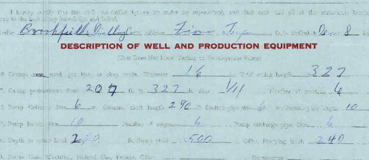
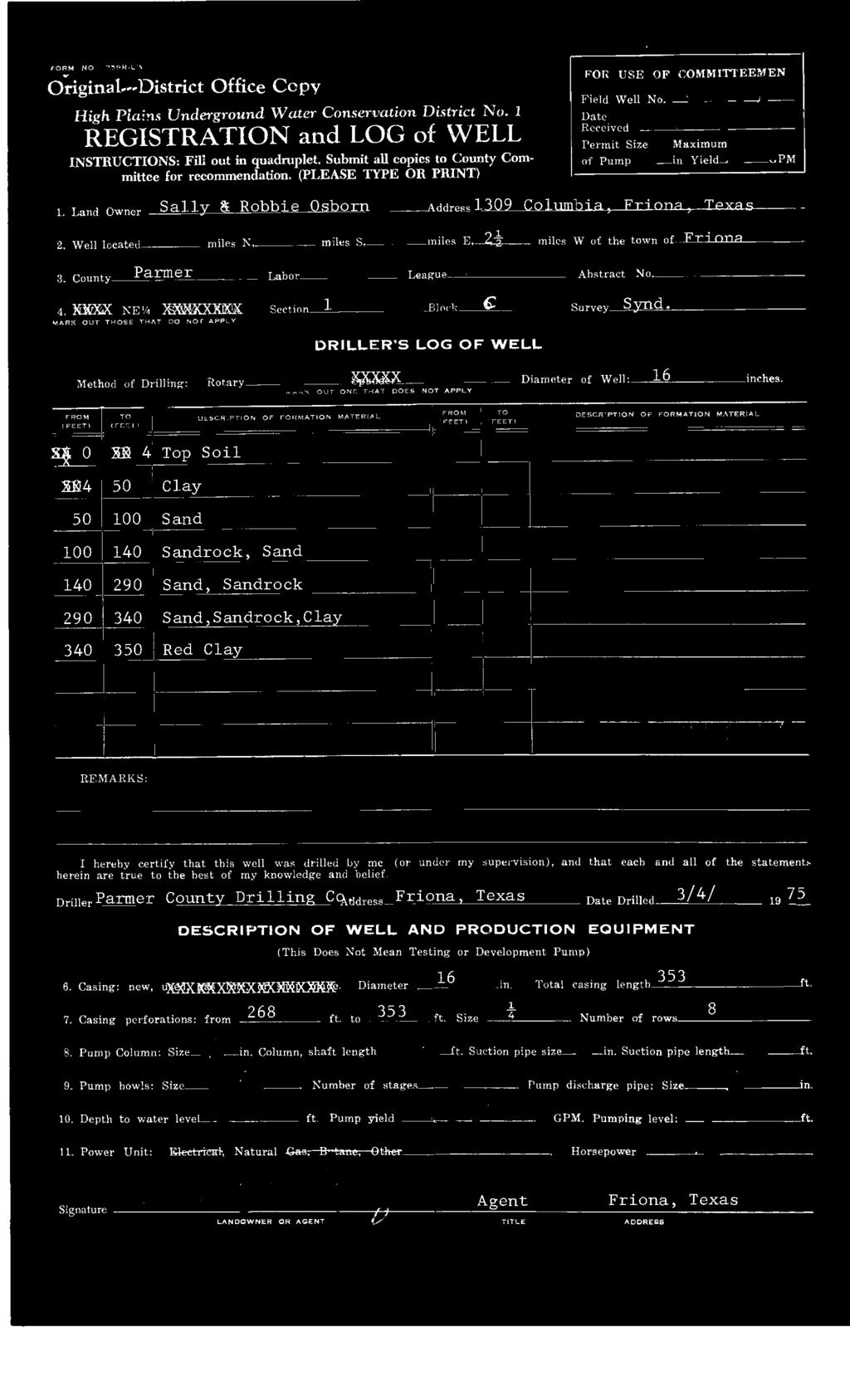
1 TRACT 7: ±252 Acres Irrigated Farmland Grassland 1880 FM 2013, Friona, Texas ±252 acres of irrigated farmland and grassland. This farmland is currently being leased and farmed. The lease agreement expires in May All planted crops are the property of the lessee and will be harvested prior to the termination date of the lease agreement. Farmground 1,300 ft. Zimmatic Center Pivot Sprinkler ± acres covered by the sprinkler 3 Irrigation Wells HPWD Well HPWD Well HPWD Well Flow Test GPM 2006 Flow Test GPM 2006 Flow Test GPM 2 Wells currently plumbed to the storage tank on Tract 6 which is plumbed to pump north to the feedyard. Grassland HPWD Well HPWD Well Flow Test GPM 2006 Flow Test GPM ± 90 acres east of circle includes natural playa lake

2 High Plains Water District Well Map (Interactive maps available at


3


4


5


6


7


8


9


10


11


12


13

14 Soil Map Parmer County, Texas (HEC FRIONA Tract 7) ' 59'' W 34 38' 30'' N Natural Resources Conservation Service Web Soil Survey National Cooperative Soil Survey 2/15/2016 Page 1 of ' 30'' N ' 59'' W ' 49'' W 34 37' 52'' N 34 37' 52'' N ' 49'' W N Map Scale: 1:8,210 if printed on A landscape (11" x 8.5") sheet. Meters Feet Map projection: Web Mercator Corner coordinates: WGS84 Edge tics: UTM Zone 13N WGS84
15 Soil Map Parmer County, Texas (HEC FRIONA Tract 7) MAP LEGEND MAP INFORMATION Area of Interest (AOI) Soils Area of Interest (AOI) Soil Map Unit Polygons Soil Map Unit Lines Soil Map Unit Points Special Point Features Blowout Borrow Pit Clay Spot Closed Depression Gravel Pit Gravelly Spot Landfill Lava Flow Marsh or swamp Mine or Quarry Miscellaneous Water Perennial Water Spoil Area Stony Spot Very Stony Spot Wet Spot Other Water Features Transportation Background Special Line Features Streams and Canals Rails Interstate Highways US Routes Major Roads Local Roads Aerial Photography The soil surveys that comprise your AOI were mapped at 1:24,000. Warning: Soil Map may not be valid at this scale. Enlargement of maps beyond the scale of mapping can cause misunderstanding of the detail of mapping and accuracy of soil line placement. The maps do not show the small areas of contrasting soils that could have been shown at a more detailed scale. Please rely on the bar scale on each map sheet for map measurements. Source of Map: Natural Resources Conservation Service Web Soil Survey URL: Coordinate System: Web Mercator (EPSG:3857) Maps from the Web Soil Survey are based on the Web Mercator projection, which preserves direction and shape but distorts distance and area. A projection that preserves area, such as the Albers equal-area conic projection, should be used if more accurate calculations of distance or area are required. This product is generated from the USDA-NRCS certified data as of the version date(s) listed below. Soil Survey Area: Parmer County, Texas Survey Area Data: Version 12, Sep 23, 2015 Soil map units are labeled (as space allows) for map scales 1:50,000 or larger. Rock Outcrop Saline Spot Sandy Spot Severely Eroded Spot Sinkhole Date(s) aerial images were photographed: Oct 6, 2010 Apr 14, 2011 The orthophoto or other base map on which the soil lines were compiled and digitized probably differs from the background imagery displayed on these maps. As a result, some minor shifting of map unit boundaries may be evident. Slide or Slip Sodic Spot Natural Resources Conservation Service Web Soil Survey National Cooperative Soil Survey 2/15/2016 Page 2 of 3
16 Soil Map Parmer County, Texas HEC FRIONA Tract 7 Map Unit Legend Parmer County, Texas (TX369) Map Unit Symbol Map Unit Name Acres in AOI Percent of AOI AcB Acuff loam, 1 to 3 percent slopes BvA Bovina loam, 0 to 1 percent slopes BvB Bovina loam, 1 to 3 percent slopes McA McLean clay, 0 to 1 percent slopes, occasionally ponded OcA Olton clay loam, 0 to 1 percent slopes PuA Pullman clay loam, 0 to 1 percent slopes % % % % % % Totals for Area of Interest % Natural Resources Conservation Service Web Soil Survey National Cooperative Soil Survey 2/15/2016 Page 3 of 3
17
18
19 Parmer CAD esearch 2015 Property Taxes will be paid at closing from the sellers proceeds. TRACTS 6 & 7 Property ID: 4812 For Year 2016! Property Details! Property Values Account Property ID: 4812 Legal Description: BLOCK C, LOT NW AC PF SEC 1, ACRES Improvement Homesite Value: Improvement Non-Homesite Value: Land Homesite Value: N\A N\A N\A Geographic ID: 5-00C Land Non-Homesite Value: N\A Agent Code: Agricultural Market Valuation: N\A Type: Real Location Market Value: N\A Address: Ag Use Value: N\A Map ID: Neighborhood CD: NONE Appraised Value: N\A Owner HS Cap: N\A Owner ID: Name: HEC FEEDYARD LLC Assessed Value: N\A Mailing Address: % Ownership: 100.0% % TEXZONA PO BOX 307 FRIONA, TX DISCLAIMER: Information provided for research purposes only. Legal descriptions and acreage amounts are for appraisal district use only and should be verified prior to using for legal purpose and or documents. Exemptions: For privacy reasons not all exemptions are shown online.! Property Taxing Jurisdiction Entity Description Tax Rate Market Value Taxable Value Estimated Tax Freeze Ceiling CAD Parmer County Appraisal District N\A N\A N\A N\A N\A GPA PARMER COUNTY N\A N\A N\A N\A N\A HPC PARMER COUNTY HOSPITAL N\A N\A N\A N\A N\A RFM FM ROAD N\A N\A N\A N\A N\A SFR FRIONA ISD N\A N\A N\A N\A N\A WHP HIGH PLAINS WATER N\A N\A N\A N\A N\A Total Tax Rate: N\A Estimated Taxes With Exemptions: N\A Estimated Taxes Without Exemptions: N\A! Property Improvement - Building Type: REAL State Code: E2 Living Area: 1,440.00sqft Value: N\A Type Description Class CD Year Built SQFT MH MOBILE HOME M24 0 1, CVP COVEREDPORCH * SD SHED 41L BRN BARN 11L , SD SHED 41L TANK TANK * ! Property Land Type Description Acres Sqft Eff Front Eff Depth Market Value Prod. Value DC1 DRY CROP ,742, N\A N\A DC2 DRY CROP , N\A N\A IC1 IRRIGATED CROP ,227, N\A N\A SP SPECIAL , N\A N\A
20 ! Property Roll Value History Year Improvements Land Market Ag Valuation Appraised HS Cap Assessed 2016 N\A N\A N\A N\A N\A N\A 2015 $53,372 $274,946 $0 $328,318 $0 $328, $50,994 $203,554 $0 $254,548 $0 $254, $50,994 $213,535 $0 $264,529 $0 $264, $50,994 $176,526 $0 $227,520 $0 $227, $41,213 $188,526 $44,472 $85,685 $0 $85, $41,213 $151,367 $46,322 $87,535 $0 $87, $41,213 $167,554 $56,448 $97,661 $0 $97, $0 $152,292 $49,830 $49,830 $0 $49, $0 $127,208 $49,830 $49,830 $0 $49,830! Property Deed History Deed Date Type Description Grantor Grantee Volume Page Number 5/17/2011 WD WARRANTY DEED TEXZONA FRIONA LLC HEC FEEDYARD LLC /1/2004 REEVE FLOYD TEXZONA FRIONA LLC! Estimated Tax Due NOTE: Indicated amount due may not reflect delinquent tax due beyond a 5 year history. Partial payments or contract payments may not be reflected. Quarterly payments according to Section of the Texas Property Tax Code are not considered delinquent. For the most current tax due amount please contact the Appraisal District. If Paid: 2/22/2016 " Pay Taxes Year Taxing Jurisdiction Taxable Value Base Tax Base Taxes Paid Base Tax Due Discount/Penalty & Interest Attorney Fees Amount Due 2016 PARMER COUNTY N\A N\A N\A N\A N\A N\A N\A 2016 PARMER COUNTY HOSPITAL N\A N\A N\A N\A N\A N\A N\A 2016 FM ROAD N\A N\A N\A N\A N\A N\A N\A 2016 FRIONA ISD N\A N\A N\A N\A N\A N\A N\A 2016 HIGH PLAINS WATER N\A N\A N\A N\A N\A N\A N\A 2016 Total: N\A N\A N\A N\A N\A N\A 2015 PARMER COUNTY $328,318 $1, $0.00 $1, $99.65 $0.00 $1, PARMER COUNTY HOSPITAL $328,318 $ $0.00 $ $55.82 $0.00 $ FM ROAD $328,318 $ $0.00 $ $24.82 $0.00 $ FRIONA ISD $328,318 $3, $0.00 $3, $ $0.00 $3, HIGH PLAINS WATER $328,318 $26.35 $0.00 $26.35 $1.84 $0.00 $ Total: $6, $0.00 $6, $ $0.00 $6, PARMER COUNTY $254,548 $1, $1, $0.00 $0.00 $0.00 $ PARMER COUNTY HOSPITAL $254,548 $ $ $0.00 $0.00 $0.00 $ FM ROAD $254,548 $ $ $0.00 $0.00 $0.00 $ FRIONA ISD $254,548 $2, $2, $0.00 $0.00 $0.00 $ HIGH PLAINS WATER $254,548 $20.43 $20.43 $0.00 $0.00 $0.00 $ Total: $4, $4, $0.00 $0.00 $0.00 $ PARMER COUNTY $264,529 $1, $1, $0.00 $0.00 $0.00 $ PARMER COUNTY HOSPITAL $264,529 $ $ $0.00 $0.00 $0.00 $ FM ROAD $264,529 $ $ $0.00 $0.00 $0.00 $ FRIONA ISD $264,529 $2, $2, $0.00 $0.00 $0.00 $ HIGH PLAINS WATER $264,529 $21.43 $21.43 $0.00 $0.00 $0.00 $ Total: $4, $4, $0.00 $0.00 $0.00 $ PARMER COUNTY $227,520 $ $ $0.00 $0.00 $0.00 $ PARMER COUNTY HOSPITAL $227,520 $ $ $0.00 $0.00 $0.00 $ FM ROAD $227,520 $ $ $0.00 $0.00 $0.00 $ FRIONA ISD $227,520 $2, $2, $0.00 $0.00 $0.00 $ HIGH PLAINS WATER $227,520 $17.16 $17.16 $0.00 $0.00 $0.00 $ Total: $4, $4, $0.00 $0.00 $0.00 $0.00
21 2011 PARMER COUNTY $85,685 $ $ $0.00 $0.00 $0.00 $ PARMER COUNTY HOSPITAL $85,685 $ $ $0.00 $0.00 $0.00 $ FM ROAD $85,685 $80.72 $80.72 $0.00 $0.00 $0.00 $ FRIONA ISD $85,685 $ $ $0.00 $0.00 $0.00 $ HIGH PLAINS WATER $85,685 $6.65 $6.65 $0.00 $0.00 $0.00 $ Total: $1, $1, $0.00 $0.00 $0.00 $ PARMER COUNTY $87,535 $ $ $0.00 $0.00 $0.00 $ PARMER COUNTY HOSPITAL $87,535 $ $ $0.00 $0.00 $0.00 $ FM ROAD $87,535 $85.43 $85.43 $0.00 $0.00 $0.00 $ FRIONA ISD $87,535 $ $ $0.00 $0.00 $0.00 $ HIGH PLAINS WATER $87,535 $6.87 $6.87 $0.00 $0.00 $0.00 $ Total: $1, $1, $0.00 $0.00 $0.00 $ PARMER COUNTY $97,661 $ $ $0.00 $0.00 $0.00 $ PARMER COUNTY HOSPITAL $97,661 $ $ $0.00 $0.00 $0.00 $ FM ROAD $97,661 $93.56 $93.56 $0.00 $0.00 $0.00 $ FRIONA ISD $97,661 $ $ $0.00 $0.00 $0.00 $ HIGH PLAINS WATER $97,661 $7.75 $7.75 $0.00 $0.00 $0.00 $ Total: $1, $1, $0.00 $0.00 $0.00 $ PARMER COUNTY $49,830 $ $ $0.00 $0.00 $0.00 $ PARMER COUNTY HOSPITAL $49,830 $ $ $0.00 $0.00 $0.00 $ FM ROAD $49,830 $49.83 $49.83 $0.00 $0.00 $0.00 $ FRIONA ISD $49,830 $ $ $0.00 $0.00 $0.00 $ HIGH PLAINS WATER $49,830 $3.96 $3.96 $0.00 $0.00 $0.00 $ Total: $ $ $0.00 $0.00 $0.00 $ PARMER COUNTY $49,830 $ $ $0.00 $0.00 $0.00 $ PARMER COUNTY HOSPITAL $49,830 $ $ $0.00 $0.00 $0.00 $ FM ROAD $49,830 $56.36 $56.36 $0.00 $0.00 $0.00 $ FRIONA ISD $49,830 $ $ $0.00 $0.00 $0.00 $ HIGH PLAINS WATER $49,830 $3.96 $3.96 $0.00 $0.00 $0.00 $ Total: $ $ $0.00 $0.00 $0.00 $0.00 DISCLAIMER: Information provided for research purposes only. Legal descriptions and acreage amounts are for appraisal district use only and should be verified prior to using for legal purpose and or documents.
T his map is for illus trative purpos es only and does not repres ent a s urvey. I t is provided 'as is ' without warranty or any repres entation of
 http://montgomerytx.mygisonline.com/print/?extent=2988061.71355584,14087737.6935746,299... 3/2/2017 10:41 AM 20 Montgomery CAD, TX Date Printed: 3 /2 /2017 T his map is for illus trative purpos es only
Custom Soil Resource Report. Soil Map. Map projection: Web Mercator Corner coordinates: WGS84 Edge tics: UTM Zone 14N WGS84. Feet.
 Custom Soil Resource Report Soil Map 3188500 3188700 3188900 3189100 3189300 3189500 3189700 96 43' 30'' W 3188500 3188700 3188900 3189100 3189300 3189500 3189700 96 42' 11'' W 28 48' 59'' N 28 48' 59''
Custom Soil Resource Report for Victoria County, Texas
 United States Department of Agriculture Natural Resources Conservation Service A product of the National Cooperative Soil Survey, a joint effort of the United States Department of Agriculture and other
CALIFORNIA AGRICULTURAL PR OPERTIES, IN C. GALE RANCH
 CALIFORNIA AGRICULTURAL PR OPERTIES, IN C. GALE RANCH LOCATION: The Ranch is located 6 Yi miles west of the City of Davis on the northwest corner of County Roads 29A and 92E in Yolo County. SIZE: 368.64
Custom Soil Resource Report Soil Map
 78 10' 44'' W Custom Soil Resource Report Soil Map 78 9' 40'' W 40 37' 18'' N 738700 738800 738900 739000 739100 739200 739300 739400 739500 739600 739700 739800 739900 740000 740100 40 37' 18'' N 4499700
CRUM RANCH AREA MAP YOLO COUNTY, California, AC +/-
 CRUM RANCH AREA MAP YOLO COUNTY, California, 235.59 AC +/- Map data 2016 Google Imagery 2016, CAPCOG, DigitalGlobe, Texas Orthoimagery Program, U.S. Geological Survey, USDA Farm Service Agency Boundary
RANCHO de DOS PALMAS DAVIS, California, AC +/-
 RANCHO de DOS PALMAS DAVIS, California, 507.28 AC +/- Boundary Transmission Line Pond / Tank Well SCOTT STONE P: (530) 662-4094 sastone57@gmail.com 37874 County Road 28, Woodland, Ca. 95695 The information
FOR SALE. Features Rives Road Petersburg, Virginia Chris Jenkins
 FOR SALE 3513 Rives Road Petersburg, Virginia 23805 Chris Jenkins T 804-228-4928 E cjenkins@ commonwealthcommercial.com Bill Barnett T 804-433-1821 E bbarnett@ commonwealthcommercial.com Features 142±
Soil Map Boulder County Area, Colorado (Planet Blue Grass) Web Soil Survey National Cooperative Soil Survey
 Web Soil Survey National Cooperative Soil Survey") 475910 476000 476090 476180 476270 476360 105 16' 21'' W 476450 476540 476630 476720 476810 4453350 4453440 4453260 4453350 4453170 4453260 4453080 4453170 4453080 475820 475910 4452990 476000 476090 476180
475910 476000 476090 476180 476270 476360 105 16' 21'' W 476450 476540 476630 476720 476810 4453350 4453440 4453260 4453350 4453170 4453260 4453080 4453170 4453080 475820 475910 4452990 476000 476090 476180
BUNCOMBE COUNTY NORTH CAROLINA
 PROJECT SITE ² 0 0. 75 1. 5 LOCATION MAP MARCH 2018 2. 25 3 Mil es AID: PROJECT # 2018-01122 18.05301 Sheet 1 of 7 Sources: Esri, HERE, DeLorme, USGS, Intermap, INCREMENT P, NRCan, Esri Japan, METI, Esri
Custom Soil Resource Report Soil Map
 121 3' 56'' W Custom Soil Resource Report Soil Map 121 2' 49'' W 45 16' 39'' N 5013800 5014000 5014200 5014400 5014600 5014800 5015000 5015200 5015400 5015600 651800 652000 652200 652400 652600 652800
Custom Soil Resource Report for Forrest County, Mississippi
 United States Department of Agriculture Natural Resources Conservation Service A product of the National Cooperative Soil Survey, a joint effort of the United States Department of Agriculture and other
Hartmann Ranch. potential vineyard ground acres +/
 Hartmann Ranch potential vineyard ground 95.403 acres +/ Location: Description: Water: Improvements: Crop history This ranch is located on Jefferson Blvd just South of North Courtland Road a few miles
CALIFORNIA AGRICULTURAL PR OPERTIES, IN C. BOWLSBEY 320 LIBERTY ISLAND ROAD BUYER: RASSMUSSEN TRUST
 CALIFORNIA AGRICULTURAL PR OPERTIES, IN C. BOWLSBEY 320 LIBERTY ISLAND ROAD SELLER: BOWLSBEY TRUST BUYER: RASSMUSSEN TRUST LOCATION: The Bowlsbey 320 is located ten (10) miles southeast of the City of
Exhibit RMP-4. Foote Creek Geology and Topography
 Exhibit RMP-4 Foote Creek Geology and Topography Memorandum To: From: CC: Travis Brown, PacifiCorp Daria Drago, P.E., PMP Dr. Deb Luchsinger Date: January 9, 2019 Re: Foote Creek Rim 1 - Geologic Conditions
Web Soil Survey National Cooperative Soil Survey
 121 52' 18'' W Irrigated Capability Class Sutter County, California () 121 51' 49'' W 597600 597700 597800 597900 598000 598100 598200 39 6' 27'' N 39 6' 27'' N 39 5' 57'' N 4328400 4328500 4328600 4328700
Web Soil Survey National Cooperative Soil Survey
 122 14' 27'' W () 122 13' 37'' W 40 8' 40'' N 564700 564800 564900 565000 565100 565200 565300 565400 565500 565600 565700 565800 40 8' 40'' N 4443400 4443500 4443600 4443700 4443800 4443900 4444000 4443400
Cripps Ranch 76+/- Acres Orchard Development Opportunity Dixon, CA. Presented By:
 Cripps Ranch 76+/- Acres Orchard Development Opportunity Dixon, CA Presented By: Cripps Ranch 76+/- Acres Orchard Development Opportunity Dixon, CA Location: This property is located at 5663 Dally Road
² 2015 Program Year. Farm Tract McLeod County, Minnesota 1:4, NHEL NHEL
 United States Department of Agriculture McLeod County, Minnesota Farm 5125 #* 2 3.65 NHEL Tract 2762 1 33.19 NHEL ² 2015 Program Year Map Created November 06, 2014 Common Land Unit Cropland Non-cropland
Web Soil Survey National Cooperative Soil Survey
 252500 252600 252700 252800 252900 253000 253100 83 47' 15'' W 83 47' 49'' W Nonirrigated Capability Class Jackson and Owsley Counties, Kentucky (Peggy Wilson Booneville Property - ) 253200 253300 37 25'
Hydric Rating by Map Unit Harrison County, Mississippi. Web Soil Survey National Cooperative Soil Survey
 89 9' 7'' W 89 8' 38'' W 30 34' 13'' N 30 33' 57'' N 3383480 3383560 3383640 3383720 3383800 3383880 3383960 293640 293720 293800 293880 293960 294040 294120 294200 294280 294360 3383480 3383560 3383640
Hydric Rating by Map Unit Harrison County, Mississippi
 89 6' 12'' W 89 5' 54'' W 30 28' 47'' N 30 28' 26'' N 3373210 3373290 3373370 3373450 3373530 3373610 3373690 3373770 3373850 298080 298160 298240 298320 298400 298480 298560 30 28' 47'' N Soil Map may
Using the Web Soil Survey Resilience and Resistance Score Sheet Soils Report
 Using the Resilience and Resistance Score Sheet Soils Report 1. Go to http://websoilsurvey.nrcs.usda.gov/app/ and click on the Start WSS button. 2. Create an Area of Interest (AOI) using any of the available
Hydric Rating by Map Unit Ocean County, New Jersey (Larsen & N New Prospect Jackson Twp., NJ)
") 74 16' 14'' W Hydric Rating by Map Unit Ocean County, New Jersey ( ) 74 15' 50'' W 40 9' 17'' N 40 8' 53'' N 4444460 4444550 4444640 4444730 4444820 4444910 4445000 4445090 4445180 562120 562210 562300
74 16' 14'' W Hydric Rating by Map Unit Ocean County, New Jersey ( ) 74 15' 50'' W 40 9' 17'' N 40 8' 53'' N 4444460 4444550 4444640 4444730 4444820 4444910 4445000 4445090 4445180 562120 562210 562300
Custom Soil Resource Report for Clackamas County Area, Oregon
 United States Department of Agriculture Natural Resources Conservation Service A product of the National Cooperative Soil Survey, a joint effort of the United States Department of Agriculture and other
Custom Soil Resource Report for Valley County, Montana
 United States Department of Agriculture Natural Resources Conservation Service A product of the National Cooperative Soil Survey, a joint effort of the United States Department of Agriculture and other
Custom Soil Resource Report for Multnomah County Area, Oregon
 United States Department of Agriculture Natural Resources Conservation Service A product of the National Cooperative Soil Survey, a joint effort of the United States Department of Agriculture and other
Web Soil Survey National Cooperative Soil Survey
 95 30' 19'' W Soil Taxonomy Classification Franklin County, Kansas 95 29' 28'' W 38 33' 8'' N 281700 281800 281900 282000 282100 282200 282300 282400 282500 282600 282700 282800 282900 38 33' 8'' N 4269300
Custom Soil Resource Report for Clackamas County Area, Oregon
 United States Department of Agriculture Natural Resources Conservation Service A product of the National Cooperative Soil Survey, a joint effort of the United States Department of Agriculture and other
Soil Map Polk County, Florida
 Soil Map Polk County, Florida 28 9' 21'' 28 8' 23'' 3113000 3113200 3113400 3113600 3113800 3114000 3114200 3114400 3114600 81 51' 19'' 81 51' 19'' 416000 416000 ± 416200 416200 68 416400 68 416400 7 13
Appendix 2b. NRCS Soil Survey
 Appendix 2b NRCS Soil Survey 118 19' 25'' W Nonirrigated Capability Class Antelope Valley Area, California (Del Sur Solar Site) 118 17' 28'' W 378900 379200 379500 379800 380100 380400 380700 381000 381300
Web Soil Survey National Cooperative Soil Survey
 95 27' 24'' W Soil Taxonomy Classification Franklin County, Kansas 95 26' 23'' W 285800 285900 286000 286100 286200 286300 286400 286500 286600 286700 286800 286900 287000 287100 287200 38 29' 34'' N 38
Producing Chandler Walnut Orchard
 AG-LAND Investment Brokers 275 Sale Lane Red Bluff, CA 96080 530-529-4400 Fax 530-527-5042 Producing Chandler Walnut Orchard West Sacramento Avenue - Chico, CA AG-LAND INVESTMENT BROKERS 275 Sale Lane
Wright County, MN. Overview. Legend
 Wright County, MN Overview 461 ft Legend Roads CSAHCL CTYCL MUNICL PRIVATECL TWPCL Highways Interstate State Hwy US Hwy City/Township Limits c t Subdivisions Parcels Water 2' Contours 842; 844; 846; 848;
Soil Taxonomy Classification Jackson County, Florida (Chipola River) Web Soil Survey National Cooperative Soil Survey
 Web Soil Survey National Cooperative Soil Survey") 85 10' 20'' W Soil Taxonomy Classification Jackson County, Florida () 85 9' 8'' W 30 37' 42'' N 30 37' 42'' N 30 37' 2'' N 30 37' 2'' N 85 10' 20'' W N Map Scale: 1:8,740 if printed on A landscape (11"
85 10' 20'' W Soil Taxonomy Classification Jackson County, Florida () 85 9' 8'' W 30 37' 42'' N 30 37' 42'' N 30 37' 2'' N 30 37' 2'' N 85 10' 20'' W N Map Scale: 1:8,740 if printed on A landscape (11"
Soil Taxonomy Classification Osage County, Kansas. Web Soil Survey National Cooperative Soil Survey
 95 45' 5'' W Soil Taxonomy Classification Osage County, Kansas 95 44' 3'' W 260300 260400 260500 260600 260700 260800 260900 261000 261100 261200 261300 261400 261500 261600 261700 38 33' 4'' N 38 32'
Web Soil Survey National Cooperative Soil Survey
 95 40' 40'' W 95 40' 0'' W 38 44' 27'' N 4290200 4290300 4290400 4290500 4290600 4290700 4290800 4290900 4291000 4291100 4291200 4291300 4291400 267300 267400 267500 267600 267700 267800 267900 268000
Carrick Road $798,000
 1955-2020 Carrick Road 165.76± acres Fayette/Scott Counties $798,000 Offered Exclusively By: Zach Davis Principal Broker +1.859.576.8195 www.kirkfarms.com zach@kirkfarms.com Measuring an appx. 165+/- acres,
PARADIGM ODP FORT COLLINS, CO 80525
 DRAINAGE REPORT PARADIGM ODP FORT COLLINS, CO 80525 Prepared For: Paradigm Properties, LLC 2186 Knoll Drive Ventura, CA 93003 Prepared By Coffey Engineering & Surveying 4045 St. Cloud Drive, Suite 180
Soil Taxonomy Classification Washington County, Florida (Pine Log 631A)
") 85 54' 36'' W Soil Taxonomy Classification Washington County, Florida () 85 53' 22'' W 30 25' 42'' N 30 25' 42'' N 30 24' 17'' N 30 24' 17'' N 85 54' 36'' W N Map Scale: 1:12,700 if printed on A portrait
85 54' 36'' W Soil Taxonomy Classification Washington County, Florida () 85 53' 22'' W 30 25' 42'' N 30 25' 42'' N 30 24' 17'' N 30 24' 17'' N 85 54' 36'' W N Map Scale: 1:12,700 if printed on A portrait
Custom Soil Resource Report for Bell County, Texas
 United States Department of Agriculture Natural Resources Conservation Service A product of the National Cooperative Soil Survey, a joint effort of the United States Department of Agriculture and other
Custom Soil Resource Report for St. Lucie County, Florida
 United States Department of Agriculture Natural Resources Conservation Service A product of the National Cooperative Soil Survey, a joint effort of the United States Department of Agriculture and other
Soil Taxonomy Classification Gadsden County, Florida (Imperial Nursery)
") 84 35' 33'' W 84 38' 3'' W Soil Taxonomy Classification Gadsden County, Florida () 30 32' 17'' N 30 32' 17'' N Map Scale: 1:25,700 if printed on A portrait (8.5" x 11") sheet. N 0 350 700 0 1000 2000 4000
84 35' 33'' W 84 38' 3'' W Soil Taxonomy Classification Gadsden County, Florida () 30 32' 17'' N 30 32' 17'' N Map Scale: 1:25,700 if printed on A portrait (8.5" x 11") sheet. N 0 350 700 0 1000 2000 4000
Hydric Rating by Map Unit Harrison County, Mississippi 30 27' 27'' 30 26' 57''
 Hydric Rating by Map Unit Harrison County, Mississippi 30 27' 27'' 30 26' 57'' 3370400 3370500 3370600 3370700 3370800 3370900 3371000 3371100 3371200 89 2' 40'' 89 2' 41'' 303700 303700 303800 303800
Custom Soil Resource Report for Potter County, Texas
 United States Department of Agriculture Natural Resources Conservation Service A product of the National Cooperative Soil Survey, a joint effort of the United States Department of Agriculture and other
Sacramento River Farmland Anderson, California
 AG-LAND INVESTMENT BROKERS 275 Sale Lane / P. O. Box 896 Red Bluff, CA 96080 530.529.4400 office / 530.527.5042 fax Sacramento River Farmland Anderson, California Property: 45 +/- acres of farmland with
Chittenden Road Prune Orchard Corning, California
 AG-LAND INVESTMENT BROKERS 275 Sale Lane / P. O. Box 896 Red Bluff, CA 96080 530.529.4400 office / 530.527.5042 fax Chittenden Road Prune Orchard Corning, California Property: 40.00 acres planted to producing
Custom Soil Resource Report for Kern County, California, Northwestern Part
 United States Department of Agriculture Natural Resources Conservation Service A product of the National Cooperative Soil Survey, a joint effort of the United States Department of Agriculture and other
Custom Soil Resource Report for Polk County, Oregon
 United States Department of Agriculture Natural Resources Conservation Service A product of the National Cooperative Soil Survey, a joint effort of the United States Department of Agriculture and other
O\.OLSSON \ ASSOC I ATES
 O\.OLSSON \ ASSOC I ATES NRCS Soils Report Larry D. Knox Juniper Hills Private Landing Strip ) OAProject No. 012-1776 760 Horizon Drive, Suite 1021 Grand Junction, CO 815061 TEL 970.263.7800 I FAX 970.263.7456
Custom Soil Resource Report for Missoula County Area, Montana
 United States Department of Agriculture Natural Resources Conservation Service A product of the National Cooperative Soil Survey, a joint effort of the United States Department of Agriculture and other
Aqua Dome Express Car Wash
 Aqua Dome Express Car Wash Stormwater Design Calculations Prepared by: 6997 Professional Parkway East, Suite B Lakewood Ranch, Florida 34240 (941) 444-6644 www.morrisengineering.net Prepared for: Florida
Custom Soil Resource Report for Stevens County, Washington
 United States Department of Agriculture Natural Resources Conservation Service A product of the National Cooperative Soil Survey, a joint effort of the United States Department of Agriculture and other
Custom Soil Resource Report for Cuyahoga County, Ohio
 United States Department of Agriculture Natural Resources Conservation Service A product of the National Cooperative Soil Survey, a joint effort of the United States Department of Agriculture and other
Custom Soil Resource Report for Columbus County, North Carolina
 United States Department of Agriculture Natural Resources Conservation Service A product of the National Cooperative Soil Survey, a joint effort of the United States Department of Agriculture and other
Custom Soil Resource Report for Clackamas County Area, Oregon, and Marion County Area, Oregon
 United States Department of Agriculture Natural Resources Conservation Service A product of the National Cooperative Soil Survey, a joint effort of the United States Department of Agriculture and other
Fall River Valley Irrigated Farmland
 AG-LAND Investment Brokers 275 Sale Lane Red Bluff, CA 96080 530-529-4400 Fax 530-527-5042 Fall River Valley Irrigated Farmland Tehama McArthur, County, California 2015 well, 16 inch casing, 150 HP, 2,000
Custom Soil Resource Report for Solano County, California
 United States Department of Agriculture Natural Resources Conservation Service A product of the National Cooperative Soil Survey, a joint effort of the United States Department of Agriculture and other
Alliance Ag Services, LLC
 United States Department of Agriculture Natural Resources Conservation Service Alliance Ag Services, LLC A product of the National Cooperative Soil Survey, a joint effort of the United States Department
Custom Soil Resource Report for Clark County, Washington
 United States Department of Agriculture Natural Resources Conservation Service A product of the National Cooperative Soil Survey, a joint effort of the United States Department of Agriculture and other
Custom Soil Resource Report for Fresno County, California, Western Part
 United States Department of Agriculture Natural Resources Conservation Service A product of the National Cooperative Soil Survey, a joint effort of the United States Department of Agriculture and other
Custom Soil Resource Report for Island County, Washington
 United States Department of Agriculture Natural Resources Conservation Service A product of the National Cooperative Soil Survey, a joint effort of the United States Department of Agriculture and other
Custom Soil Resource Report for Southampton County, Virginia
 United States Department of Agriculture Natural Resources Conservation Service A product of the National Cooperative Soil Survey, a joint effort of the United States Department of Agriculture and other
Custom Soil Resource Report for Clackamas County Area, Oregon
 United States Department of Agriculture Natural Resources Conservation Service A product of the National Cooperative Soil Survey, a joint effort of the United States Department of Agriculture and other
Custom Soil Resource Report for Atlantic County, New Jersey
 United States Department of Agriculture Natural Resources Conservation Service A product of the National Cooperative Soil Survey, a joint effort of the United States Department of Agriculture and other
Custom Soil Resource Report for Palo Verde Area, California
 United States Department of Agriculture Natural Resources Conservation Service A product of the National Cooperative Soil Survey, a joint effort of the United States Department of Agriculture and other
Custom Soil Resource Report for Wright County, Minnesota
 United States Department of Agriculture Natural Resources Conservation Service A product of the National Cooperative Soil Survey, a joint effort of the United States Department of Agriculture and other
Custom Soil Resource Report for Coryell County, Texas
 United States Department of Agriculture Natural Resources Conservation Service A product of the National Cooperative Soil Survey, a joint effort of the United States Department of Agriculture and other
Old Thomasson Range, Chico, CA
 AG-LAND INVESTMENT BROKERS 275 Sale Lane, Suite 2 / P. O. Box 896 Red Bluff, CA 96080 530.529.4400 office / 530.527.5042 fax Old Thomasson Range, Chico, CA Property: Approximately 5,270 acres bordered
Custom Soil Resource Report for Clackamas County Area, Oregon
 United States Department of Agriculture Natural Resources Conservation Service A product of the National Cooperative Soil Survey, a joint effort of the United States Department of Agriculture and other
Custom Soil Resource Report for Livingston Parish, Louisiana
 United States Department of Agriculture Natural Resources Conservation Service A product of the National Cooperative Soil Survey, a joint effort of the United States Department of Agriculture and other
Custom Soil Resource Report for San Luis Obispo County, California, Paso Robles Area
 United States Department of Agriculture Natural Resources Conservation Service A product of the National Cooperative Soil Survey, a joint effort of the United States Department of Agriculture and other
Custom Soil Resource Report for Santa Fe Area, New Mexico, Santa Fe County and Part of Rio Arriba County; and Santa Fe County Area, New Mexico
 United States Department of Agriculture Natural Resources Conservation Service A product of the National Cooperative Soil Survey, a joint effort of the United States Department of Agriculture and other
Custom Soil Resource Report for Wasco County, Oregon, Northern Part
 United States Department of Agriculture Natural Resources Conservation Service A product of the National Cooperative Soil Survey, a joint effort of the United States Department of Agriculture and other
Custom Soil Resource Report for Polk County, Oregon
 United States Department of Agriculture Natural Resources Conservation Service A product of the National Cooperative Soil Survey, a joint effort of the United States Department of Agriculture and other
Custom Soil Resource Report for Hamilton County, Texas
 United States Department of Agriculture Natural Resources Conservation Service A product of the National Cooperative Soil Survey, a joint effort of the United States Department of Agriculture and other
Aperio Property Consultants, llc E. Grand Ave. Aurora, CO Phone (303) Contact: Aaron Thompson
 Contact: Aaron Thompson") Preliminary Development Plan PD Land Suitability Analysis YOUR STORAGE CENTER AT CASTLE ROCK Castle Rock, Colorado PREPARED FOR: YOUR STORAGE CENTER CASTLE ROCK, LLC 2407 Morningview Trail. Castle Rock,
Preliminary Development Plan PD Land Suitability Analysis YOUR STORAGE CENTER AT CASTLE ROCK Castle Rock, Colorado PREPARED FOR: YOUR STORAGE CENTER CASTLE ROCK, LLC 2407 Morningview Trail. Castle Rock,
Custom Soil Resource Report for Kern County, California, Southwest Part
 United States Department of Agriculture Natural Resources Conservation Service A product of the National Cooperative Soil Survey, a joint effort of the United States Department of Agriculture and other
Wetland Delineation. Proposed CVS Pharmacy 9th Street and US Highway 98 (Avenue E) Apalachicola, Franklin County, Florida
 Apalachicola, Franklin County, Florida") Wetland Delineation Proposed CVS Pharmacy 9th Street and US Highway 98 (Avenue E) Apalachicola, Franklin County, Florida August 11, 2016 Terracon Project No. 49167572 Prepared for: Halstead Montgomery,
Wetland Delineation Proposed CVS Pharmacy 9th Street and US Highway 98 (Avenue E) Apalachicola, Franklin County, Florida August 11, 2016 Terracon Project No. 49167572 Prepared for: Halstead Montgomery,
2.a.. Physical Factors General Map
 2.a.. Physical Factors General Map General Map: Provide map showing proposed site location within the State and County, depicting road(s) accessing the site. i. Provide information depicting the location
Custom Soil Resource Report for Gem County Area, Idaho
 United States Department of Agriculture Natural Resources Conservation Service A product of the National Cooperative Soil Survey, a joint effort of the United States Department of Agriculture and other
Evergreen Packaging, Inc. Waste Management Plan
 Evergreen Packaging, Inc. Waste Management Plan June 29, 2012 Waste Management Plan Prepared for: Evergreen Packaging, Inc. Pine Bluff Mill 5201 Fairfield Road Pine Bluff, AR 71601 Prepared by: GBM c &
Custom Soil Resource Report for Pinal County, Arizona, Western Part
 United States Department of Agriculture Natural Resources Conservation Service A product of the National Cooperative Soil Survey, a joint effort of the United States Department of Agriculture and other
JOINT PUBLIC NOTICE. News Release. Application Number: SPA ABQ Date: March 23, 2018 Comments Due: April 23, 2018
 JOINT PUBLIC NOTICE Application Number: SPA-2016-00139-ABQ Date: March 23, 2018 Comments Due: April 23, 2018 SUBJECT: The U.S. Army Corps of Engineers, Albuquerque District (Corps) and the U.S. Environmental
Custom Soil Resource Report for Marion County Area, Oregon
 United States Department of Agriculture Natural Resources Conservation Service A product of the National Cooperative Soil Survey, a joint effort of the United States Department of Agriculture and other
Custom Soil Resource Report for Hansford County, Texas
 United States Department of Agriculture Natural Resources Conservation Service A product of the National Cooperative Soil Survey, a joint effort of the United States Department of Agriculture and other
Custom Soil Resource Report for Polk County, Oregon
 United States Department of Agriculture Natural Resources Conservation Service A product of the National Cooperative Soil Survey, a joint effort of the United States Department of Agriculture and other
 United States Department of Agriculture Natural Resources Conservation Service A product of the National Cooperative Soil Survey, a joint effort of the United States Department of Agriculture and other
Custom Soil Resource Report for Coryell County, Texas
 United States Department of Agriculture Natural Resources Conservation Service A product of the National Cooperative Soil Survey, a joint effort of the United States Department of Agriculture and other
Custom Soil Resource Report for Falls County, Texas
 United States Department of Agriculture Natural Resources Conservation Service A product of the National Cooperative Soil Survey, a joint effort of the United States Department of Agriculture and other
Custom Soil Resource Report for Cumberland County, New Jersey
 United States Department of Agriculture Natural Resources Conservation Service A product of the National Cooperative Soil Survey, a joint effort of the United States Department of Agriculture and other
Custom Soil Resource Report for San Juan Area, Puerto Rico
 United States Department of Agriculture Natural Resources Conservation Service A product of the National Cooperative Soil Survey, a joint effort of the United States Department of Agriculture and other
APPENDICES TABLE OF CONTENTS
 APPENDICES TABLE OF CONTENTS Peak Discharge and Pond Stage Comparison Table... 1 Soils Information... 2 Control Structure Discharge Calculations... 3 Pond Stage-Storage-Discharge Table... 4 Basin Information...
Custom Soil Resource Report for Gillespie County, Texas
 United States Department of Agriculture Natural Resources Conservation Service A product of the National Cooperative Soil Survey, a joint effort of the United States Department of Agriculture and other
Custom Soil Resource Report for Custer and Pennington Counties Area, Black Hills Parts, South Dakota
 United States Department of Agriculture Natural Resources Conservation Service A product of the National Cooperative Soil Survey, a joint effort of the United States Department of Agriculture and other
Custom Soil Resource Report for Gillespie County, Texas
 United States Department of Agriculture Natural Resources Conservation Service A product of the National Cooperative Soil Survey, a joint effort of the United States Department of Agriculture and other
Custom Soil Resource Report for Montgomery County, Pennsylvania
 United States Department of Agriculture Natural Resources Conservation Service A product of the National Cooperative Soil Survey, a joint effort of the United States Department of Agriculture and other
Prairie Wings One of America s Trophy Waterfowl Hunting Properties.
 Print by artist: David Drinkard offered for sale Prairie Wings One of America s Trophy Waterfowl Hunting Properties. 1,650 (+/-) total acres Jefferson County, Arkansas represented by DISCLOSURE STATEMENT
Custom Soil Resource Report for Franklin County, Missouri
 United States Department of Agriculture Natural Resources Conservation Service A product of the National Cooperative Soil Survey, a joint effort of the United States Department of Agriculture and other
Custom Soil Resource Report for Gillespie County, Texas
 United States Department of Agriculture Natural Resources Conservation Service A product of the National Cooperative Soil Survey, a joint effort of the United States Department of Agriculture and other