Understanding Water Level Transducers. Texas Groundwater Summit San Antonio, TX 2018
|
|
|
- Polly Holland
- 5 years ago
- Views:
Transcription

1 Understanding Water Level Transducers Texas Groundwater Summit San Antonio, TX 2018


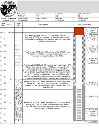
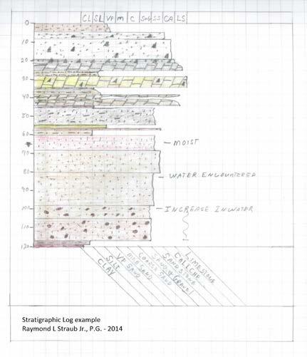
2 Presented by Raymond L Straub Jr., P.G.
3 Raymond L Straub Jr., P.G. Licensed Professional Geoscientist President of Straub Corporation Public Offices: Current Secretary of the Executive Board and GMA 2 voting member Region F Water Planning Group - 32 county Texas regional water planning Current Secretary on Board of Directors - Permian Basin Underground Water Conservation District Courses: Independent Coursework Midwest Geoscience Group - Aquifer Testing for Improved Hydrogeological Site Characterization Petroleum Professional Development Center - Introduction to Log Analysis and Petrophysics Estimating Rates of Groundwater Recharge - NGWA Groundwater Summit 2015 Deep Karst 2016 Hypogene Karst 2016 Texas Hydro-Geo Workshop 2016 ASU/AGI Electro-Resistivity Imaging Workshop Hydrogeology short course A Day with the Edwards-Trinity Aquifer 2017 Texas Hydro-Geo Workshop Professional Exams: ASBOG - Association of State Board of Geology - National Professional Geology Exam Certifications: Licensed Professional Geoscientist - State of Texas, License Master Driller - State of Texas, License 4456AI Master Driller - State of New Mexico, License WD1478 Master Pump Installer - State of Texas, License 4456AI Speaking/Lectures Middle Pecos Groundwater Conservation District Oil & Gas Environmental Issues in the Permian Basin and Pecos County Seminar Presenter; Investigative Methods for Determining Soil and Groundwater Contamination. Permian Land Girl Radio Show KWEL Radio, West Texas Groundwater Panel Broadcast 2015 KWEL Radio West Texas Groundwater and Hydrogeology Interview 2015 Angelo State University Department of Geosciences 2015 Guest Lecturer; Drill Site Geology, Outcrop Geology on a Smaller Scale. Permian Basin Oil and Gas Magazine Interview 2016 Texas Hydro-Geo Workshop - Talk on Southern Delaware Groundwater Flow Systems Angelo State University Department of Geosciences 2016 Guest Lecturer; Drill Site Geology, Outcrop Geology on a Smaller Scale. Texas Hydro-Geo Workshop - Talk on Southern Delaware Basin Groundwater Flow Systems 2017 TAGD Mobile Leadership Training Fort Stockton, Texas Research Glass Mountain Recharge Research Project An ongoing research project to monitor precipitation and runoff from an ephemeral stream channel to develop local recharge estimations utilizing precipitation monitoring and thermal infiltration arrays. In addition, develop and understand the underlying structural and flow mechanism for groundwater within the Glass Mountains area. Angelo State University Big Bend Summer Geology Field Camp; Volunteer at the Big Bend Geology Field Camp at Persimmon and Dog Canyon. Publications: Field Notes: Following the Isotope Identifying groundwater systems through stable isotopes of deuterium and oxygen Water Well Journal - National Ground Water Association July 2017 Field Notes: Electrical Resistivity Imaging Water Well Journal - National Ground Water Association February 2017 Field Notes: Faults, Fractures, and Joints Water Well Geologic Hazards Water Well Journal - National Ground Water Association November 2016 Field Notes: Solving the Three-Point Problem Water Well Journal - National Ground Water Association August 2016 Field Notes: Teaching the Next Generation Water Well Journal - National Ground Water Association February 2016 No Water No Life Foundation Map of the Surface Geology and Hydrology of the Lake Turkana Area of Kenya and Ethiopia, Africa. Smithsonian Institution and Carnegie Institute of Science. November 2015 Field Notes: Introduction to Basic Field Methods for Carbonate and Sulfate Rock Identification Water Well Journal - National Ground Water Association - November 2015 Field Notes: Retaining Geologic Samples Water Well Journal - National Ground Water Association - July 2015 Field Notes: Aquifer/Pumping Tests Water Well Journal - National Ground Water Association - May 2015 Field Notes: Measuring Geologic Features with the Pocket Transit Water Well Journal - National Ground Water Association - March 2015 Field Notes- Introduction to borehole geophysical logging Water Well Journal, National Ground Water Association - November 2014 Field Notes - Overview of Standardized Geologic Well Logs using the USCS Water Well Journal, National Ground Water Association - August 2014 Field Notes - Understanding Driller Geology Water Well Journal, National Ground Water Association - May 2014 Field Notes - Introduction to geologic maps Water Well Journal - National Ground Water Association - February 2014 Field Notes - Basic Groundwater Hydrology Water Well Journal - National Ground Water Association - November 2013 Field Notes - Introduction to basic drill site geology and borehole sample logging for groundwater professional Aquifer Types - Water Well Journal National Ground Water Association - August 2013 Field Notes - Introduction to basic drill site geology and borehole sample logging for groundwater professionals Water Well Journal National Groundwater Association - May 2013
4 Transducers Vented and Non-Vented Sensors In-Situ In-Situ


5 In-Situ 2017 In-Situ
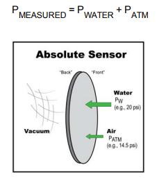
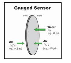
6 Absolute (non-vented) Pressure Transducers: Absolute pressure transducers have to be compensated for changes in barometric pressure Post-correction of data introduces cumulative errors Easier to deploy Less expense on cabling Gauged (vented) Pressure Transducers: Do not have to be compensated for changes in barometric pressure More expensive cabling with vent tube which is susceptible to crushing Senor is susceptible to moisture damage from vented cable


7 Smart Transducer Dataloggers versus Level Sensors In-situ 2018 Datalogger Transducers have battery, processor, and memory built into the transducer. The downhole component is typically more expensive. Sutron 2018 Level sensors are either 0-5 VDC, 4-20 ma, SDI-12, or MODBUS slave components. They are sensors that must have an external source to provide power and to collect and store data. Some dataloggers can be utilized to collect downhole temperature and other water quality parameters. Dataloggers and level sensors, with the right components, can be connected to off site networks for additional data monitoring and storage.

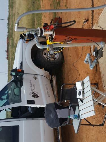
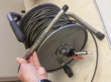
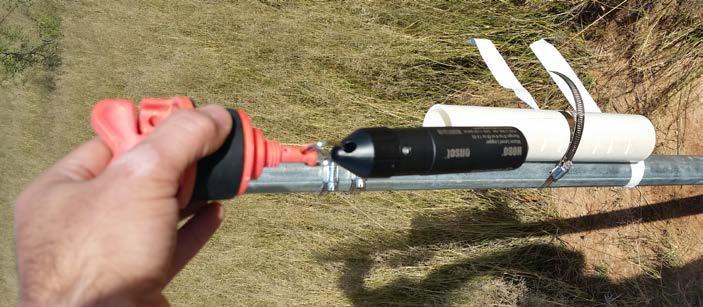
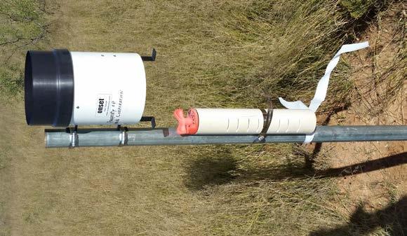
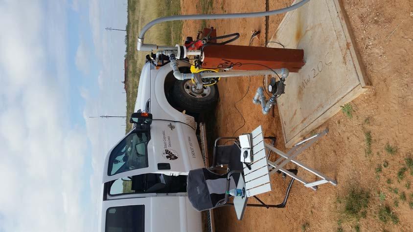
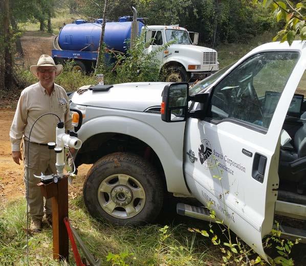
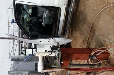
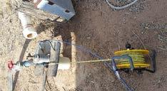
8 Prior to Deployment 1. Inspect transducers for damage, clean, and inspect sensor element. 2. Check battery, memory, and logging cycles 3. Perform open-air test to ensure proper measurement and calibration of transducer. 4. Apply proper correction value for weight of water. 5. Calibrate water quality sensors 6. Ensure desiccant is sufficient for duration of deployment. 7. Collect static water level and measuring point measurements prior to deployment. 8. Ensure transducer is secure and protected after deployment.
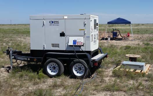
9 Barometric and Precipitation Charts Off-Site Barometer On-Site Instrumentation Off-Site Precipitation Events

10 Barometric Efficiency

11 Manual Barometric Efficiency Calculation A quite data segment is important to calculate proper efficiency.
12 Pumping Curve with Barometric Efficiency Correction

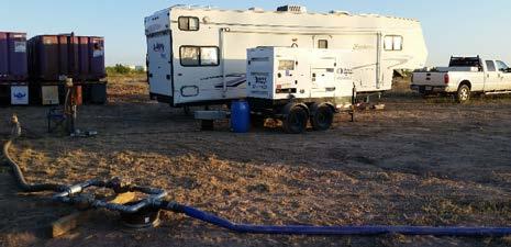
13 Train Effect or compression effect of heavy objects moving across site compressing the aquifer structure. Time of train passing on track ~1,000 ft away

14 Transient Signals Monitor the system for transient signals

15 Transient Signal from off site pumping of well field approximately 1 mile away Pumping Cycle Recovery Cycle Off Site Pumping
16 Noise and Data Errors Transducer data error was Transducer malfunctioned and a new instrument was installed without cable calibration. Unknown if aquifer had declined or cable length was out of adjustment.
17 Hydrogeological Considerations Lithology Comingling Confined, Leaky, and Unconfined Aquifers
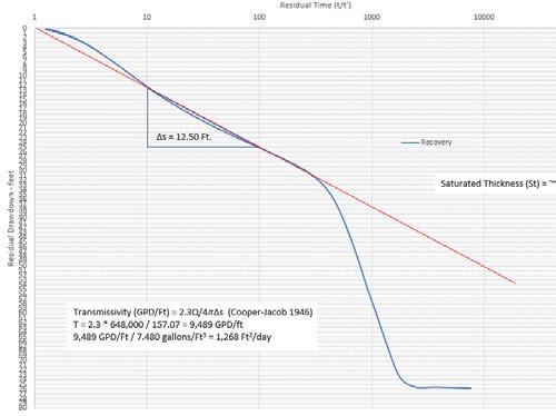
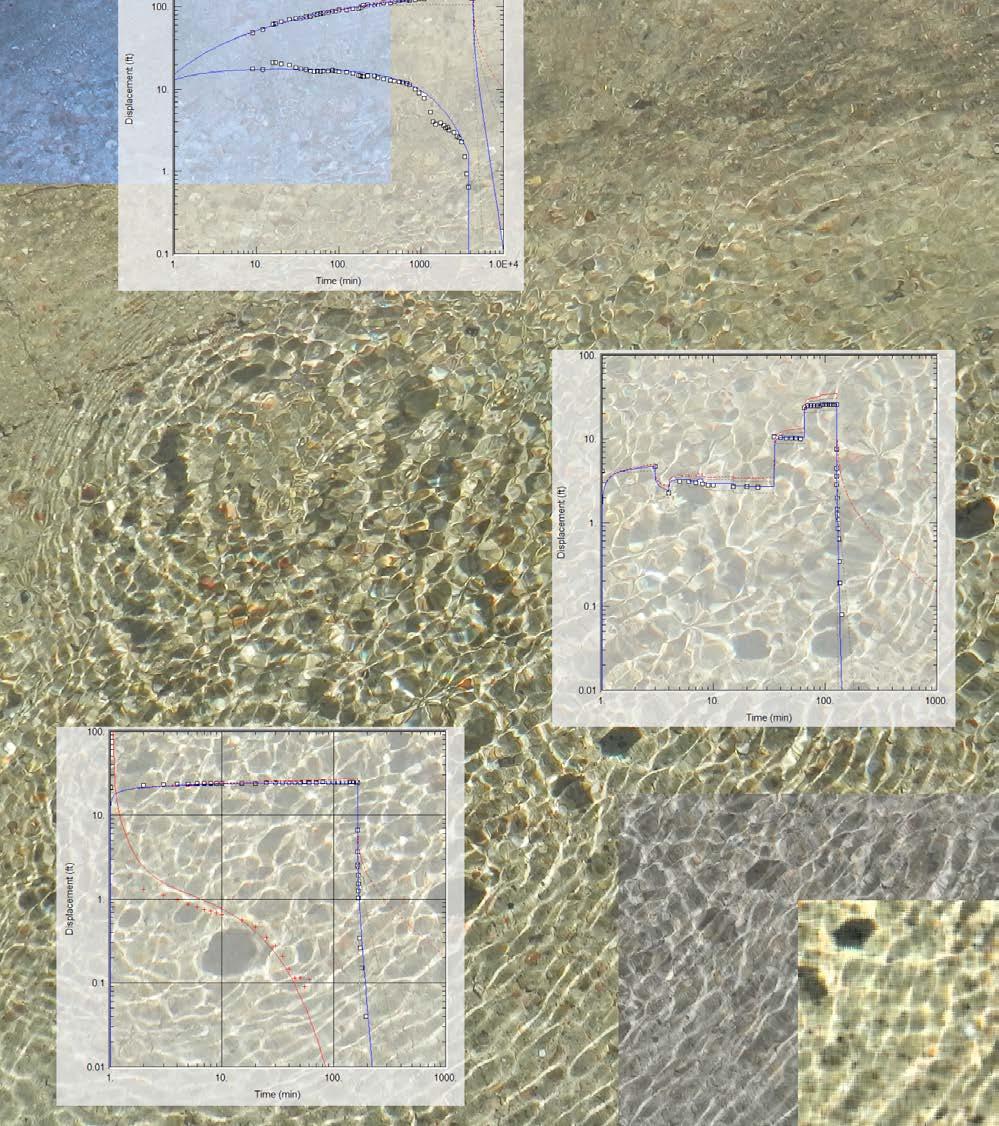
18 Combining multiple data sets to help understand aquifer characteristics Fining Upward Aquifer 72-Hour Pumping Test On Semi-log 25 GPM Potentially Leaky semi-confined Aquifer


19 Thank You Questions?
IDAWRA: Groundwater-flow model for the Wood River Valley aquifer system, south-central Idaho February 1, 2017, 11:30-1:00
 Idaho Section of the American Water Resources Association IDAWRA: Groundwater-flow model for the Wood River Valley aquifer system, south-central Idaho A three-dimensional numerical model of groundwater
APPENDIX 3B OCCURRENCE OF SIGNIFICANT RIVER ALLUVIUM AQUIFERS IN THE PLATEAU REGION
 Plateau Region Water Plan January 2011 APPENDIX 3B OCCURRENCE OF SIGNIFICANT RIVER ALLUVIUM AQUIFERS IN THE PLATEAU REGION Occurrence of Significant River Alluvium Aquifers in the Plateau Region Prepared
Soils, Hydrogeology, and Aquifer Properties. Philip B. Bedient 2006 Rice University
 Soils, Hydrogeology, and Aquifer Properties Philip B. Bedient 2006 Rice University Charbeneau, 2000. Basin Hydrologic Cycle Global Water Supply Distribution 3% of earth s water is fresh - 97% oceans 1%
Regional Groundwater Availability Study of the Edwards-Trinity Aquifer in parts of Pecos, Brewster, Jeff Davis and Reeves Counties, Texas
 Regional Groundwater Availability Study of the Edwards-Trinity Aquifer in parts of Pecos, Brewster, Jeff Davis and Reeves Counties, Texas Johnathan R. Bumgarner, P.G. Task Leads: Greg Stanton (Project
TexNet and CISR: An Update on Monitoring and Understanding Seismicity in Texas
 TexNet and CISR: An Update on Monitoring and Understanding Seismicity in Texas Michael H. Young a, Alexandros Savvaidis a, Peter Hennings a, Ellen Rathje b a Bureau of Economic Geology, Jackson School
Finding Large Capacity Groundwater Supplies for Irrigation
 Finding Large Capacity Groundwater Supplies for Irrigation December 14, 2012 Presented by: Michael L. Chapman, Jr., PG Irrigation Well Site Evaluation Background Investigation Identify Hydrogeologic Conditions
Steven K. Henderson, Ph.D.
 Steven K. Henderson, Ph.D. Texas Tech University Bob L. Herd Department of Petroleum Engineering Box 43111 Lubbock, TX 79409-3111 806.834.6388 steven.henderson@ttu.edu Licensure Certified Petroleum Geologist
Determining In Situ Properties of Claystone Aquitards Using Pore Pressure Responses from Grouted-in Pressure Transducers
 Determining In Situ Properties of Claystone Aquitards Using Pore Pressure Responses from Grouted-in Pressure Transducers Laura A. Smith, S. Lee Barbour, M. Jim Hendry University of Saskatchewan, Saskatoon,
GAM Run by Ali H. Chowdhury Ph.D., P.G. Texas Water Development Board Groundwater Resources Division (512)
") GAM Run 7-18 by Ali H. Chowdhury Ph.D., P.G. Texas Water Development Board Groundwater Resources Division (512) 936-0834 July 13, 2007 EXECUTIVE SUMMARY The groundwater availability model for the Hill
GAM Run 7-18 by Ali H. Chowdhury Ph.D., P.G. Texas Water Development Board Groundwater Resources Division (512) 936-0834 July 13, 2007 EXECUTIVE SUMMARY The groundwater availability model for the Hill
Training the Next Generation of Geoscientists to Solve Realworld Environmental Problems using Advanced Techniques: Year Two Report
 Illinois State Geological Survey 615 E. Peabody Dr. Champaign, IL 61820 Training the Next Generation of Geoscientists to Solve Realworld Environmental Problems using Advanced Techniques: Year Two Report
So How Does Professional Licensure in Geoscience Impact Me?
 So How Does Professional Licensure in Geoscience Impact Me? Christopher C. Mathewson, PhD, PE, PG Regents Professor, Emeritus, TAMU Department of Geology & Geophysics Subject Matter Expert, Council of
TAKING THE MYSTERY OUT OF USACE S ER DRILLING IN EARTH EMBANKMENT DAMS AND LEVEES
 TAKING THE MYSTERY OUT OF USACE S ER 1110-1-1807 DRILLING IN EARTH EMBANKMENT DAMS AND LEVEES 237 237 237 217 217 217 200 200 200 80 119 27 252 174.59 1 255 255 255 0 0 0 163 163 163 131 132 122 239 65
1978 MSc Geology, South Dakota School of Mines and Technology Introduction to Groundwater Vistas (Groundwater Modeling) Albuquerque, New Mexico
 Albuquerque, New Mexico") Clyde Yancey, BSc, MSc, PGeo Vice President of Exploration Education 1978 MSc Geology, South Dakota School of Mines and Technology 1975 BA Geology Trinity University 1999 Introduction to Groundwater Vistas
Clyde Yancey, BSc, MSc, PGeo Vice President of Exploration Education 1978 MSc Geology, South Dakota School of Mines and Technology 1975 BA Geology Trinity University 1999 Introduction to Groundwater Vistas
Surface Processes Focus on Mass Wasting (Chapter 10)
") Surface Processes Focus on Mass Wasting (Chapter 10) 1. What is the distinction between weathering, mass wasting, and erosion? 2. What is the controlling force in mass wasting? What force provides resistance?
Surface Processes Focus on Mass Wasting (Chapter 10) 1. What is the distinction between weathering, mass wasting, and erosion? 2. What is the controlling force in mass wasting? What force provides resistance?
10. GEOTECHNICAL EXPLORATION PROGRAM
 Geotechnical site investigations should be conducted in multiple phases to obtain data for use during the planning and design of the tunnel system. Geotechnical investigations typically are performed in
The mountain is permeable and fractured: Hydrological Connectivity in the Laramie Range
 WyCHEG Interest Group Meeting, Oct 30, 2017, Laramie, WY The mountain is permeable and fractured: Hydrological Connectivity in the Laramie Range Ye Zhang 1, Brad Carr 1, Shuangpo Ren 2, Andy Parsekian
VITA February M.Sc., Geography, concentration Karst hydrogeology and environmental geology, Western Kentucky University; July 1985.
 VITA February 2014 GEORGE VENI, Ph.D. Texas Professional Geoscientist License No. 682 507 E. Chapman Carlsbad, New Mexico 88220-9383 U.S.A. 210-863-5919, gveni@nckri.org Education Ph.D., Geology, concentration
Hydrogeology of Karst NE Wisconsin. Dr. Maureen A. Muldoon UW-Oshkosh Geology Department
 Hydrogeology of Karst NE Wisconsin Dr. Maureen A. Muldoon UW-Oshkosh Geology Department WI Bedrock Outline Karst Landscapes Existing WQ Data Flow in Karst Aquifers Overview of Silurian Aquifer Water Level
Hydrogeology of East-Central Union County, Northeastern New Mexico
 Hydrogeology of East-Central Union County, Northeastern New Mexico Geoffrey Rawling April 2013 New Mexico Bureau of Geology & Mineral Resources 1 What are the important hydrogeologic issues in Union County?
PETROLEUM GEOSCIENCES GEOLOGY OR GEOPHYSICS MAJOR
 PETROLEUM GEOSCIENCES GEOLOGY OR GEOPHYSICS MAJOR APPLIED GRADUATE STUDIES Geology Geophysics GEO1 Introduction to the petroleum geosciences GEO2 Seismic methods GEO3 Multi-scale geological analysis GEO4
Groundwater. (x 1000 km 3 /y) Reservoirs. Oceans Cover >70% of Surface. Groundwater and the. Hydrologic Cycle
 Reservoirs. Oceans Cover >70% of Surface. Groundwater and the. Hydrologic Cycle") Chapter 13 Oceans Cover >70% of Surface Groundwater and the Hydrologic Cycle Oceans are only 0.025% of Mass Groundwater Groundwater is liquid water that lies in the subsurface in fractures in rocks and
Chapter 13 Oceans Cover >70% of Surface Groundwater and the Hydrologic Cycle Oceans are only 0.025% of Mass Groundwater Groundwater is liquid water that lies in the subsurface in fractures in rocks and
Wisconsin s Hydrogeology: an overview
 2012 Soil and Water Conservation Society Conference Stevens Point, WI Feb 9, 2012 Wisconsin s Hydrogeology: an overview Ken Bradbury Wisconsin Geological and Natural History Survey University of Wisconsin-Extension
QUANTITY, MARCH 1962
 BASE-FLOW STUDIES, GUADALUPE RIVER COMAL COUNTY, TEXAS QUANTITY, MARCH 1962 TEXAS WATER COMMISSION BULLETIN 6503 MARCH 1965 TEXAS WATER COMMISSION Joe William D E 0. F. Dent Carter, Chairman Berger, Commissioner
PRELIMINARY. Select Geophysical Methods and Groundwater Modeling: Examples from USGS studies. Claudia Faunt and a cast of others
 Select Geophysical Methods and Groundwater Modeling: Examples from USGS studies Claudia Faunt and a cast of others Current Preliminary Studies Stanford Water in the West Groundwater Data Workshop Series:
Hydraulic and Water-Quality Characterization of Fractured-Rock Aquifers Using Borehole Geophysics
 Hydraulic and Water-Quality Characterization of Fractured-Rock Aquifers Using Borehole Geophysics John H. Williams Office of Ground Water Troy, New York Flow in Open Borehole Runkel and others (2003) Ambient
MICHIGAN GEOLOGICAL SURVEY Coastal Navigator Training St. Joseph, Michigan What do we know about anthropogenic impact(s) to Lake Michigan shorelines?
 to Lake Michigan shorelines?") MICHIGAN GEOLOGICAL SURVEY Coastal Navigator Training St. Joseph, Michigan What do we know about anthropogenic impact(s) to Lake Michigan shorelines? Review of a 12 year shoreline study and today, what
MICHIGAN GEOLOGICAL SURVEY Coastal Navigator Training St. Joseph, Michigan What do we know about anthropogenic impact(s) to Lake Michigan shorelines? Review of a 12 year shoreline study and today, what
Airborne Geophysics to Map Groundwater. Bill Brown
 Airborne Geophysics to Map Groundwater Bill Brown bb@skytem.com A 6 borehole represents 1 millionth of an acre Aquifer Materials An aquifer is an underground layer of water bearing permeable rock, rock
Well Drilling in Benin, West Africa 30 March 2008 Executive Summary
 Report on Expenditure of Funding Ann Campana Judge Foundation National Ground Water Research and Educational Foundation Well Drilling in Benin, West Africa 30 March 2008 Executive Summary The University
GEOLOGIC MAPS AND GEOLOGIC STRUCTURES A TEXAS EXAMPLE
 GEOLOGIC MAPS AND GEOLOGIC STRUCTURES A TEXAS EXAMPLE Roger Steinberg Assistant Professor of Geology Del Mar College 101 Baldwin Corpus Christi, TX 78404 361-698-1665 rsteinb@delmar.edu For the maps accompanying
Geophysical Exploration in Water Resources Assessment. John Mundell, P.E., L.P.G., P.G. Ryan Brumbaugh, L.P.G. Mundell & Associates, Inc.
 Geophysical Exploration in Water Resources Assessment John Mundell, P.E., L.P.G., P.G. Ryan Brumbaugh, L.P.G. Mundell & Associates, Inc. Presentation Objective Introduce the use of geophysical survey methods
Florida s Karst Geology
 Florida s Karst Geology Orange Creek Basin Interagency Working Group Public Workshop, November 5 th, 2015 Harley Means, P.G. Assistant State Geologist Florida Geological Survey Karst Karst a type of topography
Ground Water in the Piedmont and Blue Ridge
 engineering earth's development preserving earth's integrity Engineering Earth s Development Preserving Earth s Integrity Ground Water in the Piedmont and Blue Ridge Jim Renner Acknowledgements Contributors:
Prepared By: John Blair Sean Donahue Celeste Hoffman Kimberly Klinkers Megan Slater
 Prepared By: John Blair Sean Donahue Celeste Hoffman Kimberly Klinkers Megan Slater Green River Basin Location Green River Basin Stratigraphic Correlation Chart showing Study Map Units Sample of Existing
Although most karstic regions
 Urban Geophysics: Geophysical Signature of Mount Bonnell Fault and Its Karstic Features in Austin, TX by Mustafa Saribudak, Environmental Geophysics Associates, Austin, TX Although most karstic regions
Advances in Geosteering
 Advances in Geosteering SMART4D While Drilling Geosteering Marcellus Case Study Joint Presentation: Feb 27 th 2014, Houston, TX Rocky Mottahedeh, P.Geol. P.Eng. EOW Report University_31_18_2H Advances
Groundwater in Bedrock Aquifers: Development Considerations
 Slide 1 Groundwater in Bedrock Aquifers: Development Considerations Pelham, New Hampshire October 3, 2016 Building Trust. Engineering Success. Slide 2 OUTLINE Background on groundwater in bedrock aquifers
Contractor Name and Address: Oxy USA, Inc. (Oxy), Midland, Texas OBJECTIVES
, Midland, Texas OBJECTIVES") 1 F TITLE: APPLICATION OF RESERVOIR CHARACTERIZATION AND ADVANCED TECHNOLOGY TO IMPROVE RECOVERY AND ECONOMICS IN A LOWER QUALITY SHALLOW SHELF CARBONATE RESERVOIR Cooperative Agreement No.: DE - FC22-948C14990
1 F TITLE: APPLICATION OF RESERVOIR CHARACTERIZATION AND ADVANCED TECHNOLOGY TO IMPROVE RECOVERY AND ECONOMICS IN A LOWER QUALITY SHALLOW SHELF CARBONATE RESERVOIR Cooperative Agreement No.: DE - FC22-948C14990
Admission Requirements for the Geotechnical Discipline
 Admission Requirements for the Geotechnical Discipline I. General Supplementary Requirements Candidates applying for the class of Member in the Geotechnical Discipline of the HKIE must satisfy the requirements
A Short Course in Contaminated Fractured Rock Hydrogeology and Geophysics
 A Short Course in Contaminated Fractured Rock Hydrogeology and Geophysics An Eight Hour Geophysics Course Offered Through the Environmental Professionals' Organization of Connecticut Date: Nov 19, Nov
Geologging Imagery, Applications and Geological Interpretation. Shea Altadonna 1, Jim Fulton 2, E.I.T.
 Geologging Imagery, Applications and Geological Interpretation Shea Altadonna 1, Jim Fulton 2, E.I.T. 1 Geologist, Advanced Construction Techniques Inc. 1000 N. West St. Ste 1200, Wilmington, DE 19801;
12 SWAT USER S MANUAL, VERSION 98.1
 12 SWAT USER S MANUAL, VERSION 98.1 CANOPY STORAGE. Canopy storage is the water intercepted by vegetative surfaces (the canopy) where it is held and made available for evaporation. When using the curve
Overview of Geoscience Employers Workshop Outcomes
 Overview of Geoscience Employers Workshop Outcomes General thoughts on concepts: From Geoscience Employers Workshop Systems Thinking How systems work and interact Processes Atmosphere: Climate, Weather,
DATA ACQUISITION METHODS FOR GROUNDWATER INVESTIGATION AND THE SITING OF WATER SUPPLY WELLS
 DATA ACQUISITION METHODS FOR GROUNDWATER INVESTIGATION AND THE SITING OF WATER SUPPLY WELLS M.B.J. Foster Tetra Tech EM Inc., San Francisco, CA, USA Keywords: Groundwater, water wells, drilled wells, geophysical
Seismic Reflection Imaging across the Johnson Ranch, Valley County, Idaho
 Seismic Reflection Imaging across the Johnson Ranch, Valley County, Idaho Report Prepared for the Skyline Corporation Lee M. Liberty Center for Geophysical Investigation of the Shallow Subsurface (CGISS)
Groundwater Hydrology
 EXERCISE 12 Groundwater Hydrology INTRODUCTION Groundwater is an important component of the hydrologic cycle. It feeds lakes, rivers, wetlands, and reservoirs; it supplies water for domestic, municipal,
Texas Alliance of Groundwater Districts Annual Summit
 Texas Alliance of Groundwater Districts Annual Summit Using Remote-Sensed Data to Improve Recharge Estimates August 28, 2018 by Ronald T. Green1, Ph.D., P.G. and Stu Stothoff2, Ph.D., P.G. Earth Science
STUDY GUIDE FOR CONTENT MASTERY. Movement and Storage of Groundwater
 Groundwater SECTION 10.1 Movement and Storage of Groundwater In your textbook, read about the hydrosphere, precipitation and groundwater, and groundwater storage. Use the following terms to complete the
Chapter 14: Groundwater. Fig 14.5b
 Chapter 14: Groundwater Fig 14.5b OBJECTIVES Recognize that groundwater is a vital source of accessible freshwater. Describe how groundwater forms below the water table. Explain the origin of aquifers,
GEO 103. OBJECTIVES Familiarity with general facts, principles and concepts of Earth and Earth Processes
 GEO 3 Familiarity with general facts, principles and concepts of Earth and Earth Processes 1 2 5 6 7 8 Identify Earth materials and use simple geological tools Become familiar with geologic data, as displayed
WATER ON AND UNDER GROUND. Objectives. The Hydrologic Cycle
 WATER ON AND UNDER GROUND Objectives Define and describe the hydrologic cycle. Identify the basic characteristics of streams. Define drainage basin. Describe how floods occur and what factors may make
RESISTIVITY IMAGING AND BOREHOLE INVESTIGATION OF THE BANTING AREA AQUIFER, SELANGOR, MALAYSIA. A.N. Ibrahim Z.Z.T. Harith M.N.M.
 JOURNAL OF ENVIRONMENTAL HYDROLOGY The Electronic Journal of the International Association for Environmental Hydrology On the World Wide Web at http://www.hydroweb.com VOLUME 11 2003 RESISTIVITY IMAGING
Mark S. Nordberg Geology and Groundwater Investigations Section North Central Region Office California Department of Water Resources
 Mark S. Nordberg Geology and Groundwater Investigations Section North Central Region Office California Department of Water Resources Ukiah Drought Workshop July 29, 2009 Groundwater 101 Groundwater is
Hydrogeology of the Northern Segment of the Edwards Balcones Fault Zone Aquifer in the Salado Creek Basin and Environs; a current understanding
 Hydrogeology of the Northern Segment of the Edwards Balcones Fault Zone Aquifer in the Salado Creek Basin and Environs; a current understanding Introduction Purpose The Northern Segment of the Edwards
What can they teach each other? Geary M. Schindel, P.G. Chief Technical Officer Edwards Aquifer Authority San Antonio, Texas
 Cavers and Geologists What can they teach each other? Geary M. Schindel, P.G. Chief Technical Officer Edwards Aquifer Authority San Antonio, Texas Karst is a landscape where dissolution is the dominant
FRACTURE TRACES AND PRODUCTIVITY OF MUNICIPAL WELLS IN THE MADISON LIMESTONE, RAPID CITY, SOUTH DAKOTA
 Proceedings of the South Dakota Academy of Science, Vol. 87 (2008) 261 FRACTURE TRACES AND PRODUCTIVITY OF MUNICIPAL WELLS IN THE MADISON LIMESTONE, RAPID CITY, SOUTH DAKOTA Perry H. Rahn Department of
Seismoelectric Ground-flow DC-4500 Locator
 Seismoelectric Ground-flow DC-4500 Locator Introduction The seismoelectric survey is a new technology combined the electro kinetic potential method and geophysical technology. It is applied directly to
Laboratory Exercise #3 The Hydrologic Cycle and Running Water Processes
 Laboratory Exercise #3 The Hydrologic Cycle and Running Water Processes page - 1 Section A - The Hydrologic Cycle Figure 1 illustrates the hydrologic cycle which quantifies how water is cycled throughout
Delineation of Zones at Risk from Groundwater Inflows at an Underground Platinum Mine in South Africa
 Delineation of Zones at Risk from Groundwater Inflows at an Underground Platinum Mine in South Africa Mr Andreas Stoll andreas.stoll@erm.com Environmental Resources Management Swiss GmbH (ERM), Switzerland
Groundwater. (x 1000 km 3 /y) Oceans Cover >70% of Surface. Groundwater and the. Hydrologic Cycle
 Oceans Cover >70% of Surface. Groundwater and the. Hydrologic Cycle") Chapter 17 Oceans Cover >70% of Surface Groundwater and the Hydrologic Cycle Vasey s Paradise, GCNP Oceans are only 0.025% of Mass Groundwater Groundwater is liquid water that lies in the subsurface in
Chapter 17 Oceans Cover >70% of Surface Groundwater and the Hydrologic Cycle Vasey s Paradise, GCNP Oceans are only 0.025% of Mass Groundwater Groundwater is liquid water that lies in the subsurface in
Deep Borehole Field Test Overview. Presentation Overview
 Deep Borehole Field Test Overview David C. Sassani Sandia National Laboratories Used Fuel Disposition R&D Campaign The Institute for Nuclear Materials Management 32nd Spent Fuel Management Seminar Washington,
Minnesota Ground Water Association
 Fall 2006 Conference November 14, 2006 Ground Water Management The Minnesota Model - Data, Tools, Techniques, and Organization Jim Berg, Minnesota DNR Waters Mapping Hydrologic Systems Recent hydrologic/geologic
Gotechnical Investigations and Sampling
 Gotechnical Investigations and Sampling Amit Prashant Indian Institute of Technology Gandhinagar Short Course on Geotechnical Investigations for Structural Engineering 12 14 October, 2017 1 Purpose of
Seismic Guided Drilling: Near Real Time 3D Updating of Subsurface Images and Pore Pressure Model
 IPTC 16575 Seismic Guided Drilling: Near Real Time 3D Updating of Subsurface Images and Pore Pressure Model Chuck Peng, John Dai and Sherman Yang, Schlumberger WesternGeco Copyright 2013, International
Microseismicity applications in hydraulic fracturing monitoring
 Available online atwww.scholarsresearchlibrary.com Archives of Applied Science Research, 2016, 8 (4):13-19 (http://scholarsresearchlibrary.com/archive.html) ISSN 0975-508X CODEN (USA) AASRC9 Microseismicity
Karst found mostly in limestone (rock with at least 50% carbonate minerals), depends on 1) permeability & porosity
, depends on 1) permeability & porosity") KARST LANDFORMS produced by weathering & erosion in regions of carbonate rocks and evaporites processes called karstification mainly below ground surface predominantly underground drainage poorly-developed
KARST LANDFORMS produced by weathering & erosion in regions of carbonate rocks and evaporites processes called karstification mainly below ground surface predominantly underground drainage poorly-developed
Rotary Drilling Rotary Drilling Bits
 GE 343 SUBSURFACE EXPLORATION CH 8 Rock Drilling, Testing, and Sampling Text Ch. 7. Dr. Norbert H. Maerz Missouri University of Science and Technology (573) 341-6714 norbert@mst.edu Instructional Objectives
Evolution of the conceptual hydrogeologic and ground-water flow model for Las Vegas Valley, Clark County, Nevada
 Evolution of the conceptual hydrogeologic and ground-water flow model for Las Vegas Valley, Clark County, Nevada Geological Society of America Annual Meeting November 14, 2 David J. Donovan Southern Nevada
Department of Geosciences
 Department of Geosciences Department of Geosciences Interim Department Head: Dr. John Rodgers Office: 08 Hilbun Undergraduate Coordinator: Dr. Andrew Mercer Academic Coordinator: Tina Davis B.S. and M.S.
Paso Robles Groundwater Basin: Effects of Geothermal Waters on Water Quality and Availability
 Paso Robles Groundwater Basin: Effects of Geothermal Waters on Water Quality and Availability Jim Rytuba and Daniel Goldstein U.S. Geological Survey, Menlo Park, CA Paso Robles Intake from Lake Nacimiento
Association of Environmental & Engineering Geologists (AEG) To join AEG: Student membership is Free! Ask about our scholarships.
 To join AEG: Student membership is Free! Ask about our scholarships.") Association of Environmental & Engineering Geologists (AEG) To join AEG: www.aegweb.org/join Student membership is Free! Ask about our scholarships. What is the Association of Environmental & Engineering
Association of Environmental & Engineering Geologists (AEG) To join AEG: www.aegweb.org/join Student membership is Free! Ask about our scholarships. What is the Association of Environmental & Engineering
iii CONTENTS vii ACKNOWLEDGMENTS EXECUTIVE SUMMARY INTRODUCTION Study Area Data Sources Preparation of Geologic Maps
 CONTENTS ACKNOWLEDGMENTS EXECUTIVE SUMMARY INTRODUCTION Study Area Data Sources Preparation of Geologic Maps GEOLOGY Bedrock Geology Succession and Distribution Structural Features Description of Bedrock
David de Courcy-Bower and Samuel Mohr
 Applicability and Limitations of LNAPL Transmissivity as a Metric within Bedrock Formations Insert then choose Picture select your picture. Right click your picture and Send to back. David de Courcy-Bower
Napa County Comprehensive Groundwater Monitoring Program 2015 Annual Report and CASGEM Update
 Napa County Comprehensive Groundwater Monitoring Program 2015 Annual Report and CASGEM Update April 21, 2016 Watershed Information & Conservation Council By Vicki Kretsinger Grabert Overview Evolving groundwater
Teaching Field: Geology Date: 10/16/2015 Higher Learning Commission (HLC) Faculty Qualifications for Hiring
 Faculty Qualifications for Hiring") Teaching Field: Geology Date: 10/16/2015 Higher Learning Commission (HLC) Faculty Qualifications for Hiring The Geology Instructional Council of the Maricopa County Community College District is firmly
Teaching Field: Geology Date: 10/16/2015 Higher Learning Commission (HLC) Faculty Qualifications for Hiring The Geology Instructional Council of the Maricopa County Community College District is firmly
Challenges in Calibrating a Large Watershed Model with Varying Hydrogeologic Conditions
 Challenges in Calibrating a Large Watershed Model with Varying Hydrogeologic Conditions Presented by Johnathan R. Bumgarner, P.G., Celine A.L. Louwers, & Monica P. Suarez, P.E. In cooperation with the
Evaluation of the hydraulic gradient at an island for low-level nuclear waste disposal
 A New Focus on Groundwater Seawater Interactions (Proceedings of Symposium HS1001 at IUGG2007, Perugia, July 2007). IAHS Publ. 312, 2007. 237 Evaluation of the hydraulic gradient at an island for low-level
TEXAS STATE VITA. Degree Year University Major
 TEXAS STATE VITA PPS 8.10 Form 1A I. ACADEMIC/PROFESSIONAL BACKGROUND A. Name: Title: Christi G. Townsend Lecturer B. Educational Background: Degree Year University Major Ph.D. 2012 Texas State University-San
BERG-HUGHES CENTER FOR PETROLEUM AND SEDIMENTARY SYSTEMS. Department of Geology and Geophysics College of Geosciences
 BERG-HUGHES CENTER FOR PETROLEUM AND SEDIMENTARY SYSTEMS Department of Geology and Geophysics College of Geosciences MISSION Integrate geoscience, engineering and other disciplines to collaborate with
First Technical Report Geophysical experiments near Kajiado town
 First Technical Report Geophysical experiments near Kajiado town Synthesis Report of First case study within the ISGEAG VIA Water project By: Michel Groen *), Harry Rolf **), and Ammon Muiti ***) *) Acacia
The Capitan Aquifer - Ellenburger Production Wells Geothermal Engine Source?
 GEOTHERMAL ENERGY UTILIZATION ASSOCIATED WITH OIL & GAS DEVELOPMENT June 17-18, 2008 Southern Methodist University Dallas, Texas The Capitan Aquifer - Ellenburger Production Wells Geothermal Engine Source?
Instructional Objectives
 GE 343 SUBSURFACE EXPLORATION CH 8 Rock Drilling, Testing, and Sampling Text Ch. 7. Dr. Norbert H. Maerz Missouri University of Science and Technology (573) 341-6714 norbert@mst.edu Instructional Objectives
DEEP GROUND-WATER EXPLORATION IN THE FLAGSTAFF, ARIZONA AREA USING CSAMT
 DEEP GROUND-WATER EXPLORATION IN THE FLAGSTAFF, ARIZONA AREA USING CSAMT Norman R. Carlson Zonge Engineering & Research Organization, Inc. 3322 E Fort Lowell Rd Tucson, Arizona 85716 Tel: (520)327-5501
GEOCHEMISTRY UNIFORM SYLLABUS
 GEOCHEMISTRY UNIFORM SYLLABUS The Association of Professional Engineers and Geoscientists of the Province of British Columbia Note: 1. This Syllabus May Be Subject To Change 2. These Courses Are Required
Groundwater Sequence Stratigraphy:
 Groundwater Sequence Stratigraphy: A Geology-based Approach for Developing Accurate and Representative Hydrogeologic Conceptual Models for Successful Groundwater Sustainability Plans Rick Cramer, Burns
Groundwater Resources of the Las Cruces/Doña Ana County Region
 Groundwater Resources of the Las Cruces/Doña Ana County Region Presentation to Lower Rio Grande Water Users Organization Water Symposium June 6, 2007 Las Cruces, NM by Bobby J. Creel, PhD New Mexico Water
Alamitos Barrier Improvement Project - UPDATE
 Alamitos Barrier Improvement Project - UPDATE Seal Beach Leisure World Community Meeting Clubhouse 2 August 31, 2016 Orange County Water District Meeting Objectives Overview of OCWD Overview of the Alamitos
Recommendations for Injection and Storage Monitoring
 Energy and Environmental Systems Group Institute for Sustainable Energy, Environment and Economy (ISEEE) Recommendations for Injection and Storage Monitoring WABAMUN AREA CO 2 SEQUESTRATION PROJECT (WASP)
CLIMATE CHANGE ADAPTATION BY MEANS OF PUBLIC PRIVATE PARTNERSHIP TO ESTABLISH EARLY WARNING SYSTEM
 CLIMATE CHANGE ADAPTATION BY MEANS OF PUBLIC PRIVATE PARTNERSHIP TO ESTABLISH EARLY WARNING SYSTEM By: Dr Mamadou Lamine BAH, National Director Direction Nationale de la Meteorologie (DNM), Guinea President,
DRAFT. REVISED Draft. Paso Robles Subbasin Groundwater Sustainability Plan Chapter 6
 REVISED Draft Paso Robles Subbasin Groundwater Sustainability Plan Chapter 6 Prepared for the Paso Robles Subbasin Cooperative Committee and the Groundwater Sustainability Agencies February 14, 2019 Paso
LBJWC - Sinkhole Lesson
 LBJWC - Sinkhole Lesson Concept Caves and sinkholes are major openings in the ground that recharge water to the Edwards Aquifer. Objective - Students will: 1) identify a sinkhole, cave, fracture, fault,
Study of Hydrometeorology in a Hard Rock Terrain, Kadirischist Belt Area, Anantapur District, Andhra Pradesh
 Open Journal of Geology, 2012, 2, 294-300 http://dx.doi.org/10.4236/ojg.2012.24028 Published Online October 2012 (http://www.scirp.org/journal/ojg) Study of Hydrometeorology in a Hard Rock Terrain, Kadirischist
Geotechnical & Mining Engineering Services
 Geotechnical & Mining Engineering Services Southwest Research Institute San Antonio, Texas A s an independent, nonprofit research and development organization, Southwest Research Institute (SwRI ) uses
Connecticut's Aquifers
 Page 1 of 5 DEP Search: Connecticut's Aquifers The technical definition of the word "aquifer" is: any geologic formation capable of yielding significant quantities of water to wells. By that definition,
Old Oilfields vs. New Homes, Wells Case Studies, Proposed Solutions
 Old Oilfields vs. New Homes, Wells Case Studies, Proposed Solutions Patricia Billingsley, Brownfields Manager, Oklahoma Corporation Commission John Harrington, Director of Water Resources, Association
BUFFALO RIVER COALITION PO Box 101, Jasper, AR (870)
") BUFFALO RIVER COALITION PO Box 101, Jasper, AR 72641 (870) 446-5783 buffalowatershed@gmail.com Presentation before Arkansas Pollution Control and Ecology Commission, April 29, 2016 by Richard Mays on behalf
BUFFALO RIVER COALITION PO Box 101, Jasper, AR 72641 (870) 446-5783 buffalowatershed@gmail.com Presentation before Arkansas Pollution Control and Ecology Commission, April 29, 2016 by Richard Mays on behalf
MICRO LEVEL GEO-RESISTIVITY SURVEY THROUGH V.E.S. TEST FOR GROUNDWATER FEASIBILITY STUDY AND SELECTION OF BORE WELL SITES IN PIPILI BLOCK OF PURI
 Review of Environment and Earth Sciences 2014 Vol.1, No.2, pp. 37-45 ISSN(e): 2313-8440 ISSN(p): 2409-2150 DOI: 10.18488/journal.80/2014.1.2/80.2.37.45 MICRO LEVEL GEO-RESISTIVITY SURVEY THROUGH V.E.S.
Cuyama Basin North Fork Vineyard
 Cuyama Basin North Fork Vineyard Company Background plus Data Insights to Support GSP Development for the Cuyama Basin Presented by Grapevine Capital Partners and Cleath-Harris Geologists April 26th, 2018
Enhanced Characterization of the Mississippi River Valley Alluvial Aquifer Using Surface Geophysical Methods
 Photo by Shane Stocks, U.S. Geological Survey Enhanced Characterization of the Mississippi River Valley Alluvial Aquifer Using Surface Geophysical Methods Presented by Ryan F. Adams US Geological Survey
January 25, Summary
 January 25, 2013 Summary Precipitation since the December 17, 2012, Drought Update has been slightly below average in parts of central and northern Illinois and above average in southern Illinois. Soil
Geophysical Methods for Screening and Investigating Utility Waste Landfill Sites in Karst Terrain
 Geophysical Methods for Screening and Investigating Utility Waste Landfill Sites in Karst Terrain Gary Pendergrass, PE, RG, F.NSPE Principal Geological Engineer Kansas City Geotechnical Conference 2017