Simulation of hydrologic and water quality processes in watershed systems using linked SWAT-MODFLOW-RT3D model
|
|
|
- Jody Gibson
- 5 years ago
- Views:
Transcription


1 Simulation of hydrologic and water quality processes in watershed systems using linked model Ryan Bailey, Assistant Professor Xiaolu Wei, PhD student Rosemary Records, PhD student Mazdak Arabi, Associate Professor Tyler Wible, Research Associate
2 Motivation Method Improve groundwater flow and solute transport processes in SWAT Link SWAT with physically-based, spatiallydistributed groundwater models

3 Outline Code ing Applications: Little River Watershed,


4 Description Linking 3 s: SWAT Code - Groundwater model - 3D finite difference RT3D - Reactive transport - 3D finite difference

5 Description Linking 3 s: SWAT RT3D Code ET Plant Growth Uptake Volatilization Stream stage Solute transport Groundwater discharge N, P mass loading Root Zone Processes Vadose Zone Percolation, Transport Groundwater flow N, P reactive transport canal Seepage N, P transport Pumping N, P Well Concentration Confining Layer
6 Description Code Linking 3 s: SWAT Soil percolation Potential ET not satisfied River Stage Pumping required N, P in percolating water N, P in stream water Daily Interactions Water Table height GW/SW Interaction Groundwater flows, sources/sinks RT3D N, P concentrations in vadose zone Mass of N, P to/from Surface Water N, P concentrations in saturated zone
7 SWAT Code Modification Code simulate Years Days command 1: subbasin (hru calculations) 19: / RT3D Map SWAT variables Grid Recharge (soil percolation) NO 3 concentration in percolation water Stream stage Run Run RT3D Map Grid SWAT GW Discharge Subbasin streams NO 3 loading Subbasin streams 2: Route
8 Disaggregated HRUs Code Grid 1. HRU DHRUs 2. DHRUs Grid Cells 3. River Cells Subbasin JAVA code map_dhru2grid.txt map_dhru2hru.txt map_grid2dhru.txt map_river2grid.txt

9 User Interface Code SWAT input files Input Files map_dhru2grid.txt map_dhru2hru.txt map_grid2dhru.txt map_river2grid.txt Simulation

 Hydrol. Earth Syst. Sci.")
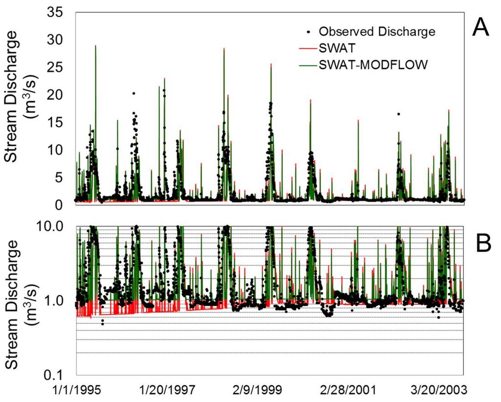
10 Basin, Oregon Code Upper - USGS (2012) ,000 grid cells SWAT Sprague Watershed SWAT Records et al (2014) Hydrol. Earth Syst. Sci. 18:


11 Basin, Oregon Simulation Results Annual Recharge Water Table Elevation Code

12 Basin, Oregon Simulation Results Groundwater Discharge to Streams Code


13 Basin, Oregon Simulation Results Nitrate Concentration in Groundwater Code

14 Basin, Oregon Simulation Results Groundwater Nitrate Loading to Streams Code

15 Little River Watershed, Collaboration with (Katrin Bieger, Hendrik Rathjens) SWAT Code smex03_little_river_micronet_ga.html
16 Little River Watershed, Collaboration with (Katrin Bieger) Code Objective: Couple SWAT with 1. Steady state model 2. transient model 3. Calibration and Testing


17 Little River Watershed, Collaboration with (Katrin Bieger) Code Grid River Cells Aquifer Thickness 2-10 m
 Groundwater Head Depth to Water")
18 Little River Watershed, Simulation Results (Steady Flow) Groundwater Head Depth to Water Table Code

19 Little River Watershed, Simulation Results Groundwater Discharge to Streams Code
20 Summary Code model Applied to two watersheds GIS/Java Pre-processing tools for linkage HRU Disaggregated HRUs DHRUs Grid Cells Grid Cells SWAT subbasins Developing: User Interface Hendrik Rathjens Create simple MODLOW model Create linkage files Public Domain (SWAT code)
21 Thank you
22

23 Code Intersections 1. HRU DHRUs 2. DHRUs Grid Cells 3. River Cells Subbasin 1. DHRU_grid.csv 2. FullDHRU.csv 3. rivergrid.csv JAVA code map_dhru2grid.txt map_dhru2hru.txt map_grid2dhru.txt map_river2grid.txt
Introduction to the new modular SWAT code: The input file structure explained using the example of the Little River Experimental Watershed, USA
 Introduction to the new modular SWAT code: The input file structure explained using the example of the Little River Experimental Watershed, USA Katrin Bieger and Jeffrey G. Arnold 2014 International SWAT
12 SWAT USER S MANUAL, VERSION 98.1
 12 SWAT USER S MANUAL, VERSION 98.1 CANOPY STORAGE. Canopy storage is the water intercepted by vegetative surfaces (the canopy) where it is held and made available for evaporation. When using the curve
SWAT 2015 International Conference:
 SWAT 2015 International Conference: Comparative Analysis of Spatial Resolution Effects on Standard and Grid-based SWAT Models Presented by: Garett Pignotti Co-authors: Dr. Hendrik Rathjens, Dr. Cibin Raj,
Two-Step Calibration Method for SWAT
 SWAT 2005 Zurich, Switzerland July 14 th, 2005 Two-Step Calibration Method for SWAT Francisco Olivera, Ph.D. Assistant Professor Huidae Cho Graduate Student Department of Civil Engineering Texas A&M University
How to integrate wetland processes in river basin modeling? A West African case study
 How to integrate wetland processes in river basin modeling? A West African case study stefan.liersch@pik-potsdam.de fred.hattermann@pik-potsdam.de June 2011 Outline Why is an inundation module required?
DEVELOPMENT AND APPLICATION OF A HYDROCLIMATOLOGICAL STREAM TEMPERATURE MODEL WITHIN SWAT
 DEVELOPMENT AND APPLICATION OF A HYDROCLIMATOLOGICAL STREAM TEMPERATURE MODEL WITHIN SWAT Darren L. Ficklin 1, Yuzhou Luo 2, Iris T. Stewart 1, Edwin P. Maurer 3 1 Environmental Studies Institute, Santa
EXAMPLE WATERSHED CONFIGURATIONS
 APPENDIX B EXAMPLE WATERSHED CONFIGURATIONS The watershed configuration file defines the spatial relationship of objects within the watershed. The three techniques used to subdivide a watershed are the
Hydrologic Modelling of the Upper Malaprabha Catchment using ArcView SWAT
 Hydrologic Modelling of the Upper Malaprabha Catchment using ArcView SWAT Technical briefs are short summaries of the models used in the project aimed at nontechnical readers. The aim of the PES India
Building a European-wide hydrological model
 Building a European-wide hydrological model 2010 International SWAT Conference, Seoul - South Korea Christine Kuendig Eawag: Swiss Federal Institute of Aquatic Science and Technology Contribution to GENESIS
Use of SWAT to Scale Sediment Delivery from Field to Watershed in an Agricultural Landscape with Depressions
 Use of SWAT to Scale Sediment Delivery from Field to Watershed in an Agricultural Landscape with Depressions James E. Almendinger St. Croix Watershed Research Station, Science Museum of Minnesota Marylee
Coupling TRIGRS and TOPMODEL in shallow landslide prediction. 1 Presenter: 王俊皓 Advisor: 李錫堤老師 Date: 2016/10/13
 Coupling TRIGRS and TOPMODEL in shallow landslide prediction 1 Presenter: 王俊皓 Advisor: 李錫堤老師 Date: 016/10/13 Outline Introduction Literature review Methodology Pre-result Future work Introduction 3 Motivation
2 Development of a Physically Based Hydrologic Model of the Upper Cosumnes Basin
 2 Development of a Physically Based Hydrologic Model of the Upper Cosumnes Basin 2.1 Introduction The physically based watershed hydrologic model, WEHY (watershed environmental hydrology) model (Kavvas
1.72, Groundwater Hydrology Prof. Charles Harvey Lecture Packet #5: Groundwater Flow Patterns. Local Flow System. Intermediate Flow System
 1.72, Groundwater Hydrology Prof. Charles Harvey Lecture Packet #5: Groundwater Flow Patterns c Local Flow System 10,000 feet Intermediate Flow System Regional Flow System 20,000 feet Hydrologic section
Hydrogeology and Simulated Effects of Future Water Use and Drought in the North Fork Red River Alluvial Aquifer: Progress Report
 Hydrogeology and Simulated Effects of Future Water Use and Drought in the North Fork Red River Alluvial Aquifer: Progress Report Developed in partnership with the Oklahoma Water Resources Board S. Jerrod
INTRODUCTION TO HEC-HMS
 INTRODUCTION TO HEC-HMS Hydrologic Engineering Center- Hydrologic Modeling System US Army Corps of Engineers Hydrologic Engineering Center HEC-HMS Uses Schematics Enter properties: watershed, rivers (reaches),
Effects of elevation bands and snow parameters on the hydrological modeling of the upper part of the Garonne watershed (France)
") Effects of elevation bands and snow parameters on the hydrological modeling of the upper part of the Garonne watershed (France) SUN, X., HONG, Y., BERNARD-JANNIN, L., CHEA, R., SAUVAGE, S., SANCHEZ-PEREZ,
Effects of elevation bands and snow parameters on the hydrological modeling of the upper part of the Garonne watershed (France) SUN, X., HONG, Y., BERNARD-JANNIN, L., CHEA, R., SAUVAGE, S., SANCHEZ-PEREZ,
Evaluation of the two stage ditch as a best management practice. A. Hodaj, L.C. Bowling, C. Raj, I. Chaubey
 Evaluation of the two stage ditch as a best management practice A. Hodaj, L.C. Bowling, C. Raj, I. Chaubey Two-stage ditch: Stage 1 : main channel Stage 2 : flood plain bench Traditional ditch Twostage
C2VSim Fine Grid (C2VSim-FG) Version Development & Applications
 Version Development & Applications") C2VSim Fine Grid (C2VSim-FG) Version Development & Applications 2014 CWEMF Annual Meeting February 24, 2014 Presenters: Ali Taghavi & Mesut Cayar Collaborators: Reza Namvar (RMC), Jim Blanke (RMC), Tariq
C2VSim Fine Grid (C2VSim-FG) Version Development & Applications 2014 CWEMF Annual Meeting February 24, 2014 Presenters: Ali Taghavi & Mesut Cayar Collaborators: Reza Namvar (RMC), Jim Blanke (RMC), Tariq
Napa County Comprehensive Groundwater Monitoring Program 2015 Annual Report and CASGEM Update
 Napa County Comprehensive Groundwater Monitoring Program 2015 Annual Report and CASGEM Update April 21, 2016 Watershed Information & Conservation Council By Vicki Kretsinger Grabert Overview Evolving groundwater
Modeling of a River Basin Using SWAT Model and SUFI-2
 Modeling of a River Basin Using SWAT Model and SUFI-2 NINA OMANI MASOUD TAJRISHY AHMAD ABRISHAMCHI Sharif University of Technology, Tehran, Iran Karkheh Dam, Iran 1 Area of Gharasu Sub-basin : 5793 km2
River Processes. Drainage Basin Morphometry
 Drainage Basin Morphometry River Processes Morphometry - the measurement and mathematical analysis of the configuration of the earth s surface and of the shape and dimensions of its landforms. Horton (1945)
Figure 1 Double-mass plots of precipitation at White Bear Lake from three gridded data sets (Daymet, HIDEN, and PRISM) versus the Minnesota Climate
 versus the Minnesota Climate") Figure 1 Double-mass plots of precipitation at White Bear Lake from three gridded data sets (Daymet, HIDEN, and PRISM) versus the Minnesota Climate Division 6 average. Straight lines through the plots
Figure 1 Double-mass plots of precipitation at White Bear Lake from three gridded data sets (Daymet, HIDEN, and PRISM) versus the Minnesota Climate Division 6 average. Straight lines through the plots
Current and Future Plans. R. Srinivasan
 Current and Future Plans R. Srinivasan Contents 1 The ArcSWAT Interface 2 VizSWAT: Output Visualization 3 User online support 4 MapWindows SWAT interface 5 ArcGIS SWAT/APEX interfaces 6 Radar Rainfall
Groundwater Modeling for Flow Systems with Complex Geological and Hydrogeological Conditions
 Available online at www.sciencedirect.com Procedia Earth and Planetary Science 3 ( 2011 ) 23 28 2011 Xi an International Conference on Fine Geological Exploration and Groundwater & Gas Hazards Control
Modelling Runoff with Satellite Data. Nyandwaro Gilbert Nyageikaro Patrick Willems Joel Kibiiy
 Modelling Runoff with Satellite Data Nyandwaro Gilbert Nyageikaro Patrick Willems Joel Kibiiy 1 Outline Background information SWAT model development The model sensitivity analysis and calibration Calibration
Conservation Planning evaluate land management alternatives to reduce soil erosion to acceptable levels. Resource Inventories estimate current and
 Conservation Planning evaluate land management alternatives to reduce soil erosion to acceptable levels. Resource Inventories estimate current and projected erosion levels and their impact on natural resource
Uncertainty analysis of nonpoint source pollution modeling:
 2013 SWAT Conference Uncertainty analysis of nonpoint source pollution modeling: An important implication for Soil and Water Assessment Tool Professor Zhenyao Shen 2013-07-17 Toulouse Contents 1 2 3 4
Tylr Naprstek Water Modeling Coordinator
 Tylr Naprstek Water Modeling Coordinator Focus development of Regional GW model for 2 basins: Loup, Elkhorn Niobrara R to Platte R Headwaters of Loup/Elkhorn to Columbus/Norfolk http://snr.unl.edu/data/geographygis/
GAM Run by Ali H. Chowdhury Ph.D., P.G. Texas Water Development Board Groundwater Resources Division (512)
") GAM Run 7-18 by Ali H. Chowdhury Ph.D., P.G. Texas Water Development Board Groundwater Resources Division (512) 936-0834 July 13, 2007 EXECUTIVE SUMMARY The groundwater availability model for the Hill
GAM Run 7-18 by Ali H. Chowdhury Ph.D., P.G. Texas Water Development Board Groundwater Resources Division (512) 936-0834 July 13, 2007 EXECUTIVE SUMMARY The groundwater availability model for the Hill
International Journal of Scientific & Engineering Research, Volume 6, Issue 8, August ISSN
 International Journal of Scientific & Engineering Research, Volume 6, Issue 8, August-2015 1670 DEM Processing for Watershed Delineation using QSWAT M.V.S.S. Giridhar 1, Ramaraju Anirudh 2, G. Sreenivasa
Napa Valley Groundwater Sustainability: A Basin Analysis Report for the Napa Valley Subbasin
 Napa Valley Groundwater Sustainability: A Basin Analysis Report for the Napa Valley Subbasin December 13, 2016 Napa County Board of Supervisors By Vicki Kretsinger Grabert and Reid Bryson Basin Analysis
Setting up SWAT to quantify water-related ecosystem services in a large East African watershed
 Benedikt Notter, University of Bern, Switzerland Setting up SWAT to quantify water-related ecosystem services in a large East African watershed 5th International SWAT Conference August 5 7, Boulder, Colorado
MODULE 8 LECTURE NOTES 2 REMOTE SENSING APPLICATIONS IN RAINFALL-RUNOFF MODELLING
 MODULE 8 LECTURE NOTES 2 REMOTE SENSING APPLICATIONS IN RAINFALL-RUNOFF MODELLING 1. Introduction The most common application of the remote sensing techniques in the rainfall-runoff studies is the estimation
LUU_CHECKER: A Tool for Dynamically Incorporating New Land Uses in SWAT
 LUU_CHECKER: A Tool for Dynamically Incorporating New Land Uses in SWAT Gurdeep Singh Ph.D. Candidate University of Arkansas Dharmendra Saraswat Associate Professor Purdue University Acknowledgements Dr.
Operational water balance model for Siilinjärvi mine
 Operational water balance model for Siilinjärvi mine Vesa Kolhinen, Tiia Vento, Juho Jakkila, Markus Huttunen, Marie Korppoo, Bertel Vehviläinen Finnish Environment Institute (SYKE) Freshwater Centre/Watershed
Modeling Upland and Channel Sources of Sediment in the Le Sueur River Watershed, Minnesota
 Modeling Upland and Channel Sources of Sediment in the Le Sueur River Watershed, Minnesota Solomon Folle and David Mulla Department of Soil, Water and Climate University of Minnesota August 6, 2009 5 th
Liliana Pagliero June, 15 th 2011
 Liliana Pagliero liliana.pagliero@jrc.ec.europa.eu June, 15 th 2011 2/18 SWAT MODELLING AT PAN EUROPEAN SCALE: THE DANUBE BASIN PILOT STUDY Introduction The Danube Model Available databases Model set up
Hydrologic and Water Quality Modeling for the Missouri River Basin (MORB)
") 2016 International SWAT Conference in Beijing, China Hydrologic and Water Quality Modeling for the Missouri River Basin (MORB) Zhonglong Zhang, PhD, PE, May Wu, PhD Courtesy of USACE Outline Missouri River
2016 International SWAT Conference in Beijing, China Hydrologic and Water Quality Modeling for the Missouri River Basin (MORB) Zhonglong Zhang, PhD, PE, May Wu, PhD Courtesy of USACE Outline Missouri River
Simulating the groundwater discharge to wetlands. Mukwonago Basin Example and Potential Application in Dane County
 Simulating the groundwater discharge to wetlands Mukwonago Basin Example and Potential Application in Dane County Conceptual Model Topography is major control on flow to wetlands Land Surface Water Table
Surface Processes Focus on Mass Wasting (Chapter 10)
") Surface Processes Focus on Mass Wasting (Chapter 10) 1. What is the distinction between weathering, mass wasting, and erosion? 2. What is the controlling force in mass wasting? What force provides resistance?
Surface Processes Focus on Mass Wasting (Chapter 10) 1. What is the distinction between weathering, mass wasting, and erosion? 2. What is the controlling force in mass wasting? What force provides resistance?
Assessment of solid load and siltation potential of dams reservoirs in the High Atlas of Marrakech (Moorcco) using SWAT Model
 using SWAT Model") Assessment of solid load and siltation potential of dams reservoirs in the High Atlas of Marrakech (Moorcco) using SWAT Model Amal Markhi: Phd Student Supervisor: Pr :N.Laftrouhi Contextualization Facing
Assessment of solid load and siltation potential of dams reservoirs in the High Atlas of Marrakech (Moorcco) using SWAT Model Amal Markhi: Phd Student Supervisor: Pr :N.Laftrouhi Contextualization Facing
Appendix D. Model Setup, Calibration, and Validation
 . Model Setup, Calibration, and Validation Lower Grand River Watershed TMDL January 1 1. Model Selection and Setup The Loading Simulation Program in C++ (LSPC) was selected to address the modeling needs
SWAT2009_LUC: A TOOL TO ACTIVATE LAND USE CHANGE MODULE IN SWAT 2009
 SWAT2009_LUC: A TOOL TO ACTIVATE LAND USE CHANGE MODULE IN SWAT 2009 Naresh Pai Dharmendra Saraswat Department of Biological & Agricultural Engineering Presented at: BACKGROUND Simulate impact of soil,
Application of HydroGeoSphere in Impact Analysis of Land Subsidence due to Increased Groundwater Withdrawal along the Delta-Mendota Canal
 Application of HydroGeoSphere in Impact Analysis of Land Subsidence due to Increased Groundwater Withdrawal along the Delta-Mendota Canal Kirk Nelson Nigel Quinn Lisa Rainger George Matanga 03/01/11 1
Spatial Distributions and Stochastic Parameter Influences on SWAT Flow and Sediment Predictions
 Spatial Distributions and Stochastic Parameter Influences on SWAT Flow and Sediment Predictions Kati W. Migliaccio 1 and Indrajeet Chaubey 2 Abstract: The Soil and Water Assessment Tool SWAT was implemented
A Post Processing Tool to Assess Sediment and Nutrient Source Allocations from SWAT Simulations
 A Post Processing Tool to Assess Sediment and Nutrient Source Allocations from SWAT Simulations Michael Van Liew William Puknat Montana Department of Environmental Quality Helena, Montana, USA PROBLEM:
Assessing Spatial and Temporal Distribution of Sediment, Nitrogen and Phosphorous Loading in the Missouri River Basin (MORB)
") Assessing Spatial and Temporal Distribution of Sediment, Nitrogen and Phosphorous Loading in the Missouri River Basin (MORB) Zhonglong Zhang, PhD, PE, May Wu, PhD LimnoTech, Environmental Laboratory, ERDC,
Assessing Spatial and Temporal Distribution of Sediment, Nitrogen and Phosphorous Loading in the Missouri River Basin (MORB) Zhonglong Zhang, PhD, PE, May Wu, PhD LimnoTech, Environmental Laboratory, ERDC,
Flow toward Pumping Well, next to river = line source = constant head boundary
 Flow toward Pumping Well, next to river = line source = constant head boundary Plan view River Channel after Domenico & Schwartz (1990) Line Source Leonhard Euler 1707-1783 e i" +1 = 0 wikimedia.org Charles
DRAFT. REVISED Draft. Paso Robles Subbasin Groundwater Sustainability Plan Chapter 6
 REVISED Draft Paso Robles Subbasin Groundwater Sustainability Plan Chapter 6 Prepared for the Paso Robles Subbasin Cooperative Committee and the Groundwater Sustainability Agencies February 14, 2019 Paso
IDAWRA: Groundwater-flow model for the Wood River Valley aquifer system, south-central Idaho February 1, 2017, 11:30-1:00
 Idaho Section of the American Water Resources Association IDAWRA: Groundwater-flow model for the Wood River Valley aquifer system, south-central Idaho A three-dimensional numerical model of groundwater
WATER ON AND UNDER GROUND. Objectives. The Hydrologic Cycle
 WATER ON AND UNDER GROUND Objectives Define and describe the hydrologic cycle. Identify the basic characteristics of streams. Define drainage basin. Describe how floods occur and what factors may make
Automatic Watershed Delineation using ArcSWAT/Arc GIS
 Automatic Watershed Delineation using ArcSWAT/Arc GIS By: - Endager G. and Yalelet.F 1. Watershed Delineation This tool allows the user to delineate sub watersheds based on an automatic procedure using
Nutrient Delivery from the Mississippi River to the Gulf of Mexico and Effects of Cropland Conservation
 Nutrient Delivery from the Mississippi River to the Gulf of Mexico and Effects of Cropland Conservation Mike White, Jeff Arnold, Lee Norfleet, Santhi Chinnasamy, and Mauro DiLuzio USDA-ARS Grassland, Soil
July, International SWAT Conference & Workshops
 July, 212 212 International SWAT Conference & Workshops Hydrological Modelling of Kosi and Gandak Basins using SWAT Model S. Dutta, Pritam Biswas, Sangita Devi, Suresh A Karth and Bimlesh kumar, Ganga
GIS BASED HYDROLOGICAL MODELLING FOR CLIMATE CHANGE IMPACT ASSESSMENT. Dr. Amardeep Singh, MoWR Prof. A. K. Gosain, IIT Delhi
 GIS BASED HYDROLOGICAL MODELLING FOR CLIMATE CHANGE IMPACT ASSESSMENT Dr. Amardeep Singh, MoWR Prof. A. K. Gosain, IIT Delhi Model Description SWAT (Soil and Water Assessment Tool) Conceptual, distributed,
Using MODIS imagery to validate the spatial representation of snow cover extent obtained from SWAT in a data-scarce Chilean Andean watershed
 Using MODIS imagery to validate the spatial representation of snow cover extent obtained from SWAT in a data-scarce Chilean Andean watershed Alejandra Stehr 1, Oscar Link 2, Mauricio Aguayo 1 1 Centro
Land Cover and Soil Properties of the San Marcos Subbasin
 Land Cover and Soil Properties of the San Marcos Subbasin Cody McCann EWRE Graduate Studies December 6, 2012 Table of Contents Project Background............................................................
Groundwater Modeling of the NorthMet Plant Site
 Groundwater Modeling of the NorthMet Plant Site Supporting Document for Water Modeling Data Package Volume 2 Plant Site Prepared for Poly Met Mining Inc. January 2015 4700 West 77th Street Minneapolis,
STREAM FLOW MODELING IN THE NACUNDAY RIVER BASIN (PARAGUAY, SOUTH AMERICA) USING SWAT MODEL. Sandra Mongelos and Manoj K. Jain
 USING SWAT MODEL. Sandra Mongelos and Manoj K. Jain") STREAM FLOW MODELING IN THE NACUNDAY RIVER BASIN (PARAGUAY, SOUTH AMERICA) USING SWAT MODEL Sandra Mongelos and Manoj K. Jain DEPARTMENT OF HYDROLOGY INDIAN INSTITUTE OF TECHNOLOGY ROORKEE ROORKEE 247
STREAM FLOW MODELING IN THE NACUNDAY RIVER BASIN (PARAGUAY, SOUTH AMERICA) USING SWAT MODEL Sandra Mongelos and Manoj K. Jain DEPARTMENT OF HYDROLOGY INDIAN INSTITUTE OF TECHNOLOGY ROORKEE ROORKEE 247
6/9/2014. Software Overview. System Overview
 Future Rainfall 6/9/2014 Curtis Beitel, PE, CFM, Anthony Henry and Wayne Tschirhart, PE, CFM, PMP TFMA Spring 2014 Conference Software Overview 2 Processes Hydrometric DB Event Manager Automatic Low =
The Sorption Properties of Humate Injected into the Subsurface System. Hansell Gonzalez Raymat DOE Fellow Graduate Student, Ph.D.
 The Sorption Properties of Humate Injected into the Subsurface System Hansell Gonzalez Raymat DOE Fellow Graduate Student, Ph.D. in Chemistry Background Background Approximately 1.8 billion gallons of
Integration of TUSLE in SWAT model for sediment prediction at a small mountainous catchment,chenyulan watershed,taiwan
 Integration of TUSLE in SWAT model for sediment prediction at a small mountainous catchment,chenyulan watershed,taiwan Presenter : Chih-Mei Lu Authors : Chih-Mei Lu, Li-Chi Chiang * Department of Civil
Application of an Enhanced, Fine-Scale SWAT Model to Target Land Management Practices for Maximizing Pollutant Reduction and Conservation Benefits
 Application of an Enhanced, Fine-Scale SWAT Model to Target Land Management Practices for Maximizing Pollutant Reduction and Conservation Benefits Amanda Flynn, Todd Redder, Joe DePinto, Derek Schlea Brian
Napa Valley Groundwater Sustainability: A Basin Analysis Report for the Napa Valley Subbasin
 Napa Valley Groundwater Sustainability: A Basin Analysis Report for the Napa Valley Subbasin A report prepared pursuant to California Water Code Section 10733.6(b)(3) EXECUTIVE SUMMARY (354.4(A)) 1 1.0
The Stochastic Event Flood Model Applied to Minidoka Dam on the Snake River, Idaho
 The Stochastic Event Flood Model Applied to Minidoka Dam on the Snake River, Idaho K. L. Bullard 1, M. G. Schaeffer 2, B. A. Barker 3, D. Sutley 4, and V. Leverson 5 1 Bureau of Reclamation, Flood Hydrology
Ms. A. Mormando's Class *
 8 th Grade Science Essential Standard: 8.E.1.1 Explain the structure of the hydrosphere including: Water distribution on Earth; Local river basin and water availability Stream - A stream is a body of water
A GIS-based Approach to Watershed Analysis in Texas Author: Allison Guettner
 Texas A&M University Zachry Department of Civil Engineering CVEN 658 Civil Engineering Applications of GIS Instructor: Dr. Francisco Olivera A GIS-based Approach to Watershed Analysis in Texas Author:
CE 394K.3 GIS in Water Resources Midterm Quiz Fall There are 5 questions on this exam. Please do all 5. They are of equal credit.
 Name: CE 394K.3 GIS in Water Resources Midterm Quiz Fall 2000 There are 5 questions on this exam. Please do all 5. They are of equal credit. 1. The ArcView Geographic Information System can display different
Gökhan Cüceloğlu, İzzet Öztürk. Istanbul Technical University Department of Environmental Engineering Maslak/IstanbulTurkey
 Assessing the Influence of Climate Datasets for Quantification of Water Balance Components in Black Sea Catchment: Case Study for Melen Watershed, Turkey Gökhan Cüceloğlu, İzzet Öztürk Istanbul Technical
Watershed simulation and forecasting system with a GIS-oriented user interface
 HydroGIS 96: Application of Geographic Information Systems in Hydrology and Water Resources Management (Proceedings of the Vienna Conference, April 1996). IAHS Publ. no. 235, 1996. 493 Watershed simulation
GIS-based Water Resource Geospatial Infrastructure for Oil Shale Development
 GIS-based Water Resource Geospatial Infrastructure for Oil Shale Development Wendy Zhou, Matthew Minnick, Mengistu Geza Colorado School of Mines, Golden, CO Kyle Murray University of Texas at San Antonio,
MEMORANDUM. Jerry Conrow, Ojai Basin Groundwater Management Agency
 MEMORANDUM TO: FROM: Jerry Conrow, Ojai Basin Groundwater Management Agency Gregory Schnaar, PhD, Stephen J. Cullen, PhD, PG, DATE: August 6, 2014, 2014 SUBJECT: Ojai Basin Groundwater Model - Extended
Soils, Hydrogeology, and Aquifer Properties. Philip B. Bedient 2006 Rice University
 Soils, Hydrogeology, and Aquifer Properties Philip B. Bedient 2006 Rice University Charbeneau, 2000. Basin Hydrologic Cycle Global Water Supply Distribution 3% of earth s water is fresh - 97% oceans 1%
Understanding riverine wetland-catchment processes using remote sensing data and modelling
 Understanding riverine wetland-catchment processes using remote sensing data and modelling Yunqing Xuan (UNESCO-IHE, NL) Didier Haguma (KIST, Rwanda) William Niyonzima (UNESCO-IHE, NL) Ann van Griensven
Field Observations and One-Dimensional Flow Modeling of Summit Creek in Mack Park, Smithfield, Utah
 Intermountain Center for River Rehabilitation and Restoration, Utah State University 31 July 2018 Field Observations and One-Dimensional Flow Modeling of Summit Creek in Mack Park, Smithfield, Utah I.
Near Real-Time Runoff Estimation Using Spatially Distributed Radar Rainfall Data. Jennifer Hadley 22 April 2003
 Near Real-Time Runoff Estimation Using Spatially Distributed Radar Rainfall Data Jennifer Hadley 22 April 2003 Introduction Water availability has become a major issue in Texas in the last several years,
Uncertainty in the SWAT Model Simulations due to Different Spatial Resolution of Gridded Precipitation Data
 Uncertainty in the SWAT Model Simulations due to Different Spatial Resolution of Gridded Precipitation Data Vamsi Krishna Vema 1, Jobin Thomas 2, Jayaprathiga Mahalingam 1, P. Athira 4, Cicily Kurian 1,
Baseflow Analysis. Objectives. Baseflow definition and significance
 Objectives Baseflow Analysis. Understand the conceptual basis of baseflow analysis.. Estimate watershed-average hydraulic parameters and groundwater recharge rates. Baseflow definition and significance
The Power of Spreadsheet Models. Mary P. Anderson 1, E. Scott Bair 2 ABSTRACT
 MODFLOW 00 and Other Modeling Odysseys Proceedings, 00, International Ground Water Modeling Center, Colorado School of Mines, Golden, CO, p. 85-8 The Power of Spreadsheet Models Mary P. Anderson, E. Scott
4.11 Groundwater model
 4.11 Groundwater model 4.11 Groundwater model 4.11.1 Introduction and objectives Groundwater models have the potential to make important contributions in the mapping and characterisation of buried valleys.
Hydraulic and Sediment Transport Modeling Strategy
 Appendix B Hydraulic and Sediment Transport Modeling Strategy May 2014 Technical Memorandum Channel Capacity Report January 2015 San Joaquin River Restoration Program Hydraulic and Sediment Transport Modeling
1.72, Groundwater Hydrology Prof. Charles Harvey Lecture Packet #4: Continuity and Flow Nets
 1.7, Groundwater Hydrology Prof. Charles Harvey Lecture Packet #4: Continuity and Flow Nets Equation of Continuity Our equations of hydrogeology are a combination of o Conservation of mass o Some empirical
Challenges in Calibrating a Large Watershed Model with Varying Hydrogeologic Conditions
 Challenges in Calibrating a Large Watershed Model with Varying Hydrogeologic Conditions Presented by Johnathan R. Bumgarner, P.G., Celine A.L. Louwers, & Monica P. Suarez, P.E. In cooperation with the
GIS in Water Resources Exercise #4 Solution Prepared by Irene Garousi-Nejad and David Tarboton
 GIS in Water Resources Exercise 4 Solution Prepared by Irene Garousi-Nejad and David Tarboton 1. Cell length (N-S) in m, width (E-W) in m, area in m 2 for the DEM cells in the merged DEM. N-S y = R e φ
Climatic Change Implications for Hydrologic Systems in the Sierra Nevada
 Climatic Change Implications for Hydrologic Systems in the Sierra Nevada Part Two: The HSPF Model: Basis For Watershed Yield Calculator Part two presents an an overview of why the hydrologic yield calculator
4. GIS Implementation of the TxDOT Hydrology Extensions
 4. GIS Implementation of the TxDOT Hydrology Extensions A Geographic Information System (GIS) is a computer-assisted system for the capture, storage, retrieval, analysis and display of spatial data. It
Application of SWAT for the modelling of sediment yield at Pong reservoir, India
 Application of SWAT for the modelling of sediment yield at Pong reservoir, India A. R. Senthil kumar Tanmoyee Bhattacharya Suhas D Khobragade Manohar Arora National Institute of Hydrology Roorkee-247667,
The mountain is permeable and fractured: Hydrological Connectivity in the Laramie Range
 WyCHEG Interest Group Meeting, Oct 30, 2017, Laramie, WY The mountain is permeable and fractured: Hydrological Connectivity in the Laramie Range Ye Zhang 1, Brad Carr 1, Shuangpo Ren 2, Andy Parsekian
Extension of the WASA model: Water and sediment routing in the river network
 Extension of the WASA model: Water and sediment routing in the river network Working Report SESAM-Project, University of Potsdam, July 2005 Eva Nora Müller enmue@uni-potsdam.de 1 Introduction to model
Transactions on Information and Communications Technologies vol 18, 1998 WIT Press, ISSN
 STREAM, spatial tools for river basins, environment and analysis of management options Menno Schepel Resource Analysis, Zuiderstraat 110, 2611 SJDelft, the Netherlands; e-mail: menno.schepel@resource.nl
In all of the following equations, is the coefficient of permeability in the x direction, and is the hydraulic head.
 Groundwater Seepage 1 Groundwater Seepage Simplified Steady State Fluid Flow The finite element method can be used to model both steady state and transient groundwater flow, and it has been used to incorporate
Water Resources Challenges in Adams County, Pennsylvania
 Water Resources Challenges in Adams County, Pennsylvania Water Availability in the Upper Monocacy River Basin (Marsh, Rock, Alloway, and Toms Creeks) May 13, 2010 Cherie Schultz, Ph.D. Interstate Commission
Groundwater. (x 1000 km 3 /y) Reservoirs. Oceans Cover >70% of Surface. Groundwater and the. Hydrologic Cycle
 Reservoirs. Oceans Cover >70% of Surface. Groundwater and the. Hydrologic Cycle") Chapter 13 Oceans Cover >70% of Surface Groundwater and the Hydrologic Cycle Oceans are only 0.025% of Mass Groundwater Groundwater is liquid water that lies in the subsurface in fractures in rocks and
Chapter 13 Oceans Cover >70% of Surface Groundwater and the Hydrologic Cycle Oceans are only 0.025% of Mass Groundwater Groundwater is liquid water that lies in the subsurface in fractures in rocks and
Comparison of Flow Calibration Using NEXRAD and Surface Rain Gauge Data in ArcSWAT
 Comparison of Flow Calibration Using NEXRAD and Surface Rain Gauge Data in ArcSWAT Presenter: Aisha M. Sexton USDA-ARS-HRSL / UMD Coauthors: Ali Sadeghi, Raghavan Srinivasan, Adel Shirmohammadi, and Xuesong
Christopher L. Shope, Svenja Bartsch, Marianne Ruidisch, Sebastian Arnhold 6 August International SWAT Conference Ilsan, South Korea
 Tractors, Rice, and Mountains: Hydrogeochemistry in Monsoonal South Korea Christopher L. Shope, Svenja Bartsch, Marianne Ruidisch, Sebastian Arnhold 6 August 2010 2010 International SWAT Conference Ilsan,
INFLOW DESIGN FLOOD CONTROL SYSTEM PLAN 40 C.F.R. PART PLANT YATES ASH POND 2 (AP-2) GEORGIA POWER COMPANY
 GEORGIA POWER COMPANY") INFLOW DESIGN FLOOD CONTROL SYSTEM PLAN 40 C.F.R. PART 257.82 PLANT YATES ASH POND 2 (AP-2) GEORGIA POWER COMPANY EPA s Disposal of Coal Combustion Residuals from Electric Utilities Final Rule (40 C.F.R.
INFLOW DESIGN FLOOD CONTROL SYSTEM PLAN 40 C.F.R. PART 257.82 PLANT YATES ASH POND 2 (AP-2) GEORGIA POWER COMPANY EPA s Disposal of Coal Combustion Residuals from Electric Utilities Final Rule (40 C.F.R.
Groundwater Replenishment In The Coachella Valley, CA. WESTCAS 2018 Annual Conference June 21, 2018 Zoe Rodriguez del Rey, Water Resources
 Groundwater Replenishment In The Coachella Valley, CA WESTCAS 2018 Annual Conference June 21, 2018 Zoe Rodriguez del Rey, Water Resources Coachella Valley Indio Mecca Palm Springs La Quinta Thermal 2 Coachella
Supplementary Material: A Guide for Using the Coupled SWAT MODSIM (SM) Model
 Model") Supplementary Material: A Guide for Using the Coupled SWAT MODSIM (SM) Model Saeid Ashraf Vaghefi (saeedashrafv@gmail.com) The coupled SWAT MODSIM (SM) is a tool that can be used in integrated watershed
Supplementary Material: A Guide for Using the Coupled SWAT MODSIM (SM) Model Saeid Ashraf Vaghefi (saeedashrafv@gmail.com) The coupled SWAT MODSIM (SM) is a tool that can be used in integrated watershed
Erosion modelling in the upper Blue Nile basin: The case of Mizewa watershed in Ethiopia
 Erosion modelling in the upper Blue Nile basin: The case of Mizewa watershed in Ethiopia Citation: Assegahegn, M.A. and Zemadim, B. Erosion modelling in the upper Blue Nile basin: The case of Mizewa watershed
GEOL 474/674 Practice Exam #1 Fall This exam counts 20% of your grade for this course; your instructions are as follows:
 Write your name here: This exam counts 20% of your grade for this course; your instructions are as follows: 1) You have 75 minutes to finish this exam. 2) No books, notes, or discussion is allowed. If