How to integrate wetland processes in river basin modeling? A West African case study
|
|
|
- Ambrose Singleton
- 5 years ago
- Views:
Transcription

1 How to integrate wetland processes in river basin modeling? A West African case study stefan.liersch@pik-potsdam.de fred.hattermann@pik-potsdam.de June 2011

2 Outline Why is an inundation module required? Case study: Inner Niger Delta How does the inundation module work? Data requirements Preprocessing Processes Model parameters Limitations 2


 Hessen")
3 Inner Niger Delta (Mali) Upper Niger Basin ~350,000 km 2 Inundated area 5,000 45,000 km 2 The Netherlands ~ 42,000 km 2 Peak discharge ,000 m 3 /s Monsoon-type of rainfall Annual rainfall ~830 mm ( mm) Hessen ~21,000 km 2 3

4 Rainfall in the Upper Niger Catchment 20 th century

5 SWIM Streamflow Simulation Koulikoro
6 6
7 X 7
8 8
9 Some Reasons to Integrate Wetland Processes To adequately simulate discharge downstream of the wetland To account for evapotranspiration losses within the wetland Important information for regional climate models Relevant for the Inner Niger Delta To assess usable area for floating rice production To assess climate change & variability impacts on agriculture, fishery, and cattle 9
10 Data Requirements Spatial Data DEM Flow accumulation map Calibration Spatial and temporal information about inundation 10
11 Preprocessing Identify wetland outlet (in GIS) Assume that wetland is a lake Flood the lake (e.g. module r.lake in GRASS GIS) Identify inundation zones Water levels [m 2 ] Inundation storage volumes [m 3 ] GRASS module r.param.scale to identify ponds (water traps) Map with grid cells that are identified as sinks (no surface runoff) 2 new HRU attributes inundation zone water trap (ponds) 11
12 Processes: Overview Flooding Routing, backwater Evaporation (water surface) Percolation Release HRUs Switch from land to water phase Parameters Flow-threshold for flooding (cross-sectional area) Parameter for release (linear storage) Backwater subbasins input file 12
![Processes: Flooding Cross-sectional area A [m 2 ] Flow velocity (bankfull) v [m*s -1 ]](/docs-images/81/83144246/images/13-0.jpg "A*v = inflow threshold [m 3 *s -1 ] Calibration parameter: correction of inflow threshold")
13 Processes: Flooding Cross-sectional area A [m 2 ] Flow velocity (bankfull) v [m*s -1 ] A*v = inflow threshold [m 3 *s -1 ] Calibration parameter: correction of inflow threshold 13
14 Processes: Routing, Backwater If inflow(sub) > flowthresh(sub) then Remove inflow volume > flowthresh from routing Route only inflow volume <= flowthresh Put excess volume into inundation storage(s) Perform leveling due to backwater effects else Route normally If upstream subbasin has a share on wetland then Perform leveling of inundation storages of corresponding subbasins 14
15 Processes: Backwater, Leveling 15


16 Processes: Backwater, Leveling Sub2, Stor1 = full 1 Subbasin 1 Subbasin 2 Sub1 flows into Sub2 2 Sub2, Stor1+2 = full 3 Leveling 4 16
17 Processes: Evaporation, Percolation If HRU inundated (threshold) then Switch from land to water phase else ET act = ET pot (water surface) No surface runoff Percolation (percolation volume = unsaturated water capacity of upper soil layer) Ground water recharge Subsurface runoff Proceed normally 17
18 Processes: Release Calculate release volume per time step Add release to volume to be routed into downstream subbasin (next time step) Calibration parameter: release coefficient [%] of storage volume 18
19 19


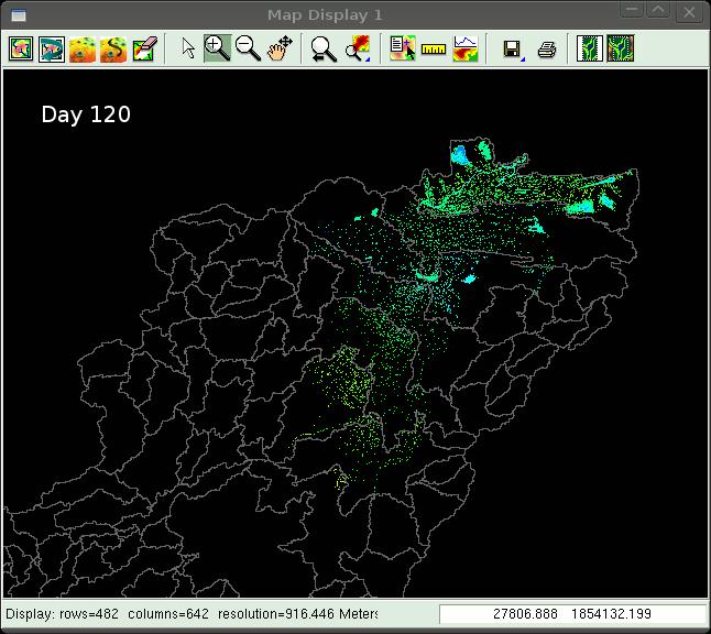
20 Inundation Usable area for floating rice 1976 wet year ~3000 km dry year ~1400 km 2 20
21 Limitations of the Current Version Scale issue, the Inner Niger Delta is a huge (meso-scale) wetland, like the Sudd in Sudan (White Nile) Can the inundation module be applied to small wetlands? Not a hydrodynamic model but process-based Not fully spatially explicit but semi-explicit Vegetation processes Ground water processes 21
22 Problems Accuracy of DEM, a few centimeters of elevation can have large impacts on inundation area Niger splits into two rivers Climate data How reliable are GPCC and CRU rainfall data in West Africa? 22
23 Thank you for your attention! 23
24 24
25 25
26 Wetland inflow Wetland outflow 26
27 SWIM Streamflow + STAR Climate Scenarios baseline scenario 20% % 45%


28 Preprocessing: Inundation Zones Wetland outlet GRASS module: r.lake Input DEM Flow accumulation xy-location water level (max. inundation depth) Output Lake area [m 2 ] Inundation Zones [m 2 ] Volume per zone [m 3 ] 28
29 How much water is evaporated in the delta? In average ~10 km 3 /a (5-20 km 3 ) New York City or Berlin inundated 10m Modification / control of routing during preprocessing SWIM MapWindow Interface 29
12 SWAT USER S MANUAL, VERSION 98.1
 12 SWAT USER S MANUAL, VERSION 98.1 CANOPY STORAGE. Canopy storage is the water intercepted by vegetative surfaces (the canopy) where it is held and made available for evaporation. When using the curve
Hydrologic Modelling of the Upper Malaprabha Catchment using ArcView SWAT
 Hydrologic Modelling of the Upper Malaprabha Catchment using ArcView SWAT Technical briefs are short summaries of the models used in the project aimed at nontechnical readers. The aim of the PES India
UGRC 144 Science and Technology in Our Lives/Geohazards
 UGRC 144 Science and Technology in Our Lives/Geohazards Flood and Flood Hazards Dr. Patrick Asamoah Sakyi Department of Earth Science, UG, Legon College of Education School of Continuing and Distance Education
DRAFT. REVISED Draft. Paso Robles Subbasin Groundwater Sustainability Plan Chapter 6
 REVISED Draft Paso Robles Subbasin Groundwater Sustainability Plan Chapter 6 Prepared for the Paso Robles Subbasin Cooperative Committee and the Groundwater Sustainability Agencies February 14, 2019 Paso
INTRODUCTION TO HEC-HMS
 INTRODUCTION TO HEC-HMS Hydrologic Engineering Center- Hydrologic Modeling System US Army Corps of Engineers Hydrologic Engineering Center HEC-HMS Uses Schematics Enter properties: watershed, rivers (reaches),
Understanding riverine wetland-catchment processes using remote sensing data and modelling
 Understanding riverine wetland-catchment processes using remote sensing data and modelling Yunqing Xuan (UNESCO-IHE, NL) Didier Haguma (KIST, Rwanda) William Niyonzima (UNESCO-IHE, NL) Ann van Griensven
Flood Forecasting Tools for Ungauged Streams in Alberta: Status and Lessons from the Flood of 2013
 Flood Forecasting Tools for Ungauged Streams in Alberta: Status and Lessons from the Flood of 2013 John Pomeroy, Xing Fang, Kevin Shook, Tom Brown Centre for Hydrology, University of Saskatchewan, Saskatoon
Project Description. Project Options. End Analysis On... Apr 26, :00:00. Rainfall Details
 Project Description File Name... 323 - Att Pond 3 East PIPES ONLY.SPF Project Options Flow Units... Elevation Type... Hydrology Method... EPA SWMM Infiltration Method... Link Routing Method... Enable Overflow
Workshop: Build a Basic HEC-HMS Model from Scratch
 Workshop: Build a Basic HEC-HMS Model from Scratch This workshop is designed to help new users of HEC-HMS learn how to apply the software. Not all the capabilities in HEC-HMS are demonstrated in the workshop
Advanced /Surface Hydrology Dr. Jagadish Torlapati Fall 2017 MODULE 2 - ROUTING METHODS
 Routing MODULE - ROUTING METHODS Routing is the process of find the distribution of flow rate and depth in space and time along a river or storm sewer. Routing is also called Flow routing or flood routing.
Operational water balance model for Siilinjärvi mine
 Operational water balance model for Siilinjärvi mine Vesa Kolhinen, Tiia Vento, Juho Jakkila, Markus Huttunen, Marie Korppoo, Bertel Vehviläinen Finnish Environment Institute (SYKE) Freshwater Centre/Watershed
Building a European-wide hydrological model
 Building a European-wide hydrological model 2010 International SWAT Conference, Seoul - South Korea Christine Kuendig Eawag: Swiss Federal Institute of Aquatic Science and Technology Contribution to GENESIS
Using Earth Observation Data for Monitoring River Basins
 Using Earth Observation Data for Monitoring River Basins The NBI Experience By Milly Mbuliro GIS/ Remote Sensing Specialist Nile Basin Initiative Secretariat NBDF, 23 rd -25 th October, Kigali Convention
2 Development of a Physically Based Hydrologic Model of the Upper Cosumnes Basin
 2 Development of a Physically Based Hydrologic Model of the Upper Cosumnes Basin 2.1 Introduction The physically based watershed hydrologic model, WEHY (watershed environmental hydrology) model (Kavvas
Influence of rainfall space-time variability over the Ouémé basin in Benin
 102 Remote Sensing and GIS for Hydrology and Water Resources (IAHS Publ. 368, 2015) (Proceedings RSHS14 and ICGRHWE14, Guangzhou, China, August 2014). Influence of rainfall space-time variability over
Setting up SWAT to quantify water-related ecosystem services in a large East African watershed
 Benedikt Notter, University of Bern, Switzerland Setting up SWAT to quantify water-related ecosystem services in a large East African watershed 5th International SWAT Conference August 5 7, Boulder, Colorado
FFGS Additional Functionalities and Products. Konstantine P. Georgakakos, Sc.D. HYDROLOGIC RESEARCH CENTER 23 May 2018
 FFGS Additional Functionalities and Products Konstantine P. Georgakakos, Sc.D. HYDROLOGIC RESEARCH CENTER 23 May 2018 Advanced Functionalities 0. Multi-Model QPF A. Urban Flash Flood Warning B. Riverine
A PROTOTYPE FOR THE APPLICATION OF CLIMATE INFORMATION TO IMPROVE HIGHWAY AND INFRASTRUCTURE PLANNING IN THE COASTAL REGIONS OF LAKE VICTORIA
 A PROTOTYPE FOR THE APPLICATION OF CLIMATE INFORMATION TO IMPROVE HIGHWAY AND INFRASTRUCTURE PLANNING IN THE COASTAL REGIONS OF LAKE VICTORIA Kara Smith October 26, 2016 Lake Victoria Levels Sudden increase
Extreme Phenomena in Dobrogea - Floods and Droughts
 Extreme Phenomena in Dobrogea - Floods and Droughts PhD eng. Carmen Maftei Ovidius University of Constanta (Partner no 4) OUTLINES Introduction Study area Drought Floods Conclusion What is the problem?
Technical Memorandum No
 Pajaro River Watershed Study in association with Technical Memorandum No. 1.2.10 Task: Evaluation of Four Watershed Conditions - Sediment To: PRWFPA Staff Working Group Prepared by: Gregory Morris and
Flood Inundation Analysis by Using RRI Model For Chindwin River Basin, Myanmar
 Flood Inundation Analysis by Using RRI Model For Chindwin River Basin, Myanmar Aye Aye Naing Supervisor : Dr. Miho Ohara MEE14625 Dr. Duminda Perera Dr. Yoshihiro Shibuo ABSTRACT Floods occur during the
Chiang Rai Province CC Threat overview AAS1109 Mekong ARCC
 Chiang Rai Province CC Threat overview AAS1109 Mekong ARCC This threat overview relies on projections of future climate change in the Mekong Basin for the period 2045-2069 compared to a baseline of 1980-2005.
Impacts of climate change on flooding in the river Meuse
 Impacts of climate change on flooding in the river Meuse Martijn Booij University of Twente,, The Netherlands m.j.booij booij@utwente.nlnl 2003 in the Meuse basin Model appropriateness Appropriate model
GEOL 1121 Earth Processes and Environments
 GEOL 1121 Earth Processes and Environments Wondwosen Seyoum Department of Geology University of Georgia e-mail: seyoum@uga.edu G/G Bldg., Rm. No. 122 Seyoum, 2015 Chapter 6 Streams and Flooding Seyoum,
GIS in Water Resources Midterm Exam Fall 2008 There are 4 questions on this exam. Please do all 4.
 Page 1 of 8 Name: GIS in Water Resources Midterm Exam Fall 2008 There are 4 questions on this exam. Please do all 4. 1. Basic Concepts [20 points] Find the letter with the best answer for each term: 1.
Coupling a basin erosion and river sediment transport model into a large scale hydrological model
 Hydrology and Geodynamics of the basins of South America 4 th scientific meeting of ORE HYBAM www.ore-hybam.org Lima, 6-9 September 2011 Coupling a basin erosion and river sediment transport model into
Preliminary Runoff Outlook February 2018
 Preliminary Runoff Outlook February 2018 Prepared by: Flow Forecasting & Operations Planning Water Security Agency General Overview The Water Security Agency (WSA) is preparing for 2018 spring runoff including
Hydrological modelling of the Lena River using SWIM
 Hydrological modelling of the Lena River using SWIM Michel Wortmann 1 1 Potsdam Institute for Climate Impact Research (PIK), Germany July 8, 214 Contents 1 The Lena catchment and data used 1 1.1 Discharge
Technical Note: Hydrology of the Lake Chilwa wetland, Malawi
 Technical Note: Hydrology of the Lake Chilwa wetland, Malawi Matthew McCartney June 27 Description Lake Chilwa is located in the Southern region of Malawi on the country s eastern boarder with Mozambique
Simulation of hydrologic and water quality processes in watershed systems using linked SWAT-MODFLOW-RT3D model
 Simulation of hydrologic and water quality processes in watershed systems using linked model Ryan Bailey, Assistant Professor Xiaolu Wei, PhD student Rosemary Records, PhD student Mazdak Arabi, Associate
MET 3102-U01 PHYSICAL CLIMATOLOGY (ID 17901) Lecture 14
 Lecture 14") MET 3102-U01 PHYSICAL CLIMATOLOGY (ID 17901) Lecture 14 The hydrologic cycle evaporation vapor transport precipitation precipitation evaporation runoff Evaporation, precipitation, etc. in cm Vapor transported
MET 3102-U01 PHYSICAL CLIMATOLOGY (ID 17901) Lecture 14 The hydrologic cycle evaporation vapor transport precipitation precipitation evaporation runoff Evaporation, precipitation, etc. in cm Vapor transported
Tarbela Dam in Pakistan. Case study of reservoir sedimentation
 Tarbela Dam in Pakistan. HR Wallingford, Wallingford, UK Published in the proceedings of River Flow 2012, 5-7 September 2012 Abstract Reservoir sedimentation is a main concern in the Tarbela reservoir
Flash Flood Guidance System On-going Enhancements
 Flash Flood Guidance System On-going Enhancements Hydrologic Research Center, USA Technical Developer SAOFFG Steering Committee Meeting 1 10-12 July 2017 Jakarta, INDONESIA Theresa M. Modrick Hansen, PhD
4 th Joint Project Team Meeting for Sentinel Asia 2011
 A Revisit on the Structural Flood Mitigation Measure with the Application of Remote Sensing and GIS in Gin River Basin, Sri Lanka 4 th Joint Project Team Meeting for Sentinel Asia 2011 Geoinformatics Center
Use of SWAT to Scale Sediment Delivery from Field to Watershed in an Agricultural Landscape with Depressions
 Use of SWAT to Scale Sediment Delivery from Field to Watershed in an Agricultural Landscape with Depressions James E. Almendinger St. Croix Watershed Research Station, Science Museum of Minnesota Marylee
DEVELOPMENT AND APPLICATION OF A HYDROCLIMATOLOGICAL STREAM TEMPERATURE MODEL WITHIN SWAT
 DEVELOPMENT AND APPLICATION OF A HYDROCLIMATOLOGICAL STREAM TEMPERATURE MODEL WITHIN SWAT Darren L. Ficklin 1, Yuzhou Luo 2, Iris T. Stewart 1, Edwin P. Maurer 3 1 Environmental Studies Institute, Santa
Estimation of ungauged Bahr el Jebel flows based on upstream water levels and large scale spatial rainfall data
 Adv. Geosci., 18, 9 13, 2008 Author(s) 2008. This work is distributed under the Creative Commons Attribution 3.0 License. Advances in Geosciences Estimation of ungauged Bahr el Jebel flows based on upstream
Watershed simulation and forecasting system with a GIS-oriented user interface
 HydroGIS 96: Application of Geographic Information Systems in Hydrology and Water Resources Management (Proceedings of the Vienna Conference, April 1996). IAHS Publ. no. 235, 1996. 493 Watershed simulation
HYDROLOGIC AND WATER RESOURCES EVALUATIONS FOR SG. LUI WATERSHED
 HYDROLOGIC AND WATER RESOURCES EVALUATIONS FOR SG. LUI WATERSHED 1.0 Introduction The Sg. Lui watershed is the upper part of Langat River Basin, in the state of Selangor which located approximately 20
Transactions on Information and Communications Technologies vol 18, 1998 WIT Press, ISSN
 STREAM, spatial tools for river basins, environment and analysis of management options Menno Schepel Resource Analysis, Zuiderstraat 110, 2611 SJDelft, the Netherlands; e-mail: menno.schepel@resource.nl
Climate Change Impact Assessment on Indian Water Resources. Ashvin Gosain, Sandhya Rao, Debajit Basu Ray
 Climate Change Impact Assessment on Indian Water Resources Ashvin Gosain, Sandhya Rao, Debajit Basu Ray Objectives of the Study To quantify the impact of the climate change on the water resources of the
MODULE 8 LECTURE NOTES 2 REMOTE SENSING APPLICATIONS IN RAINFALL-RUNOFF MODELLING
 MODULE 8 LECTURE NOTES 2 REMOTE SENSING APPLICATIONS IN RAINFALL-RUNOFF MODELLING 1. Introduction The most common application of the remote sensing techniques in the rainfall-runoff studies is the estimation
The Iowa Watershed Approach
 A vision for a more resilient Iowa Larry Weber Director, IIHR Hydroscience & Engineering Larry-weber@uiowa.edu 1 Kickoff Iowa Grant meeting Award: follow-up $96,887,177 2 How can we stay informed about
Drought Monitoring with Hydrological Modelling
 st Joint EARS/JRC International Drought Workshop, Ljubljana,.-5. September 009 Drought Monitoring with Hydrological Modelling Stefan Niemeyer IES - Institute for Environment and Sustainability Ispra -
Current and Future Plans. R. Srinivasan
 Current and Future Plans R. Srinivasan Contents 1 The ArcSWAT Interface 2 VizSWAT: Output Visualization 3 User online support 4 MapWindows SWAT interface 5 ArcGIS SWAT/APEX interfaces 6 Radar Rainfall
Conservation Planning evaluate land management alternatives to reduce soil erosion to acceptable levels. Resource Inventories estimate current and
 Conservation Planning evaluate land management alternatives to reduce soil erosion to acceptable levels. Resource Inventories estimate current and projected erosion levels and their impact on natural resource
INFLOW DESIGN FLOOD CONTROL SYSTEM PLAN 40 C.F.R. PART PLANT YATES ASH POND 2 (AP-2) GEORGIA POWER COMPANY
 GEORGIA POWER COMPANY") INFLOW DESIGN FLOOD CONTROL SYSTEM PLAN 40 C.F.R. PART 257.82 PLANT YATES ASH POND 2 (AP-2) GEORGIA POWER COMPANY EPA s Disposal of Coal Combustion Residuals from Electric Utilities Final Rule (40 C.F.R.
INFLOW DESIGN FLOOD CONTROL SYSTEM PLAN 40 C.F.R. PART 257.82 PLANT YATES ASH POND 2 (AP-2) GEORGIA POWER COMPANY EPA s Disposal of Coal Combustion Residuals from Electric Utilities Final Rule (40 C.F.R.
Uncertainty analysis of nonpoint source pollution modeling:
 2013 SWAT Conference Uncertainty analysis of nonpoint source pollution modeling: An important implication for Soil and Water Assessment Tool Professor Zhenyao Shen 2013-07-17 Toulouse Contents 1 2 3 4
CARFFG System Development and Theoretical Background
 CARFFG Steering Committee Meeting 15 SEPTEMBER 2015 Astana, KAZAKHSTAN CARFFG System Development and Theoretical Background Theresa M. Modrick, PhD Hydrologic Research Center Key Technical Components -
Determination of Urban Runoff Using ILLUDAS and GIS
 Texas A&M University Department of Civil Engineering Instructor: Dr. Francisco Olivera CVEN689 Applications of GIS to Civil Engineering Determination of Urban Runoff Using ILLUDAS and GIS Tae Jin Kim 03.
A GIS-based Approach to Watershed Analysis in Texas Author: Allison Guettner
 Texas A&M University Zachry Department of Civil Engineering CVEN 658 Civil Engineering Applications of GIS Instructor: Dr. Francisco Olivera A GIS-based Approach to Watershed Analysis in Texas Author:
Improved ensemble representation of soil moisture in SWAT for data assimilation applications
 Improved ensemble representation of soil moisture in SWAT for data assimilation applications Amol Patil and RAAJ Ramsankaran Hydro-Remote Sensing Applications (H-RSA) Group, Department of Civil Engineering
Section 4: Model Development and Application
 Section 4: Model Development and Application The hydrologic model for the Wissahickon Act 167 study was built using GIS layers of land use, hydrologic soil groups, terrain and orthophotography. Within
7.3 Sediment Delivery Analysis
 7.3 Sediment Delivery Analysis In order to evaluate potential changes in sedimentation patterns that could occur due to impacts from the FCP and LPP alignments, sediment assessment models were constructed
Appendix D. Model Setup, Calibration, and Validation
 . Model Setup, Calibration, and Validation Lower Grand River Watershed TMDL January 1 1. Model Selection and Setup The Loading Simulation Program in C++ (LSPC) was selected to address the modeling needs
INDIAN INSTITUTE OF SCIENCE STOCHASTIC HYDROLOGY. Course Instructor : Prof. P. P. MUJUMDAR Department of Civil Engg., IISc.
 INDIAN INSTITUTE OF SCIENCE STOCHASTIC HYDROLOGY Course Instructor : Prof. P. P. MUJUMDAR Department of Civil Engg., IISc. Course Contents Introduction to Random Variables (RVs) Probability Distributions
Enhancements for FFGS improved operations
 Enhancements for FFGS improved operations Hydrologic Research Center 3-5 May 2017 3-5 May 2017 HRC CAFFG 1 Enhancements to be discussed A. Multiple Mesoscale Model Input B. Urban Flash Flood Warning C.
A PARAMETER ESTIMATE FOR THE LAND SURFACE MODEL VIC WITH HORTON AND DUNNE RUNOFF MECHANISM FOR RIVER BASINS IN CHINA
 A PARAMETER ESTIMATE FOR THE LAND SURFACE MODEL VIC WITH HORTON AND DUNNE RUNOFF MECHANISM FOR RIVER BASINS IN CHINA ZHENGHUI XIE Institute of Atmospheric Physics, Chinese Academy of Sciences Beijing,
Preliminary Viability Assessment (PVA) for Lake Mendocino Forecast Informed Reservoir Operations (FIRO)
 for Lake Mendocino Forecast Informed Reservoir Operations (FIRO)") Preliminary Viability Assessment (PVA) for Lake Mendocino Forecast Informed Reservoir Operations (FIRO) Rob Hartman Consultant to SCWA and CW3E May 30, 2017 Why Conduct a PVA? Key Questions for the PVA
Preliminary Viability Assessment (PVA) for Lake Mendocino Forecast Informed Reservoir Operations (FIRO) Rob Hartman Consultant to SCWA and CW3E May 30, 2017 Why Conduct a PVA? Key Questions for the PVA
Napa Valley Groundwater Sustainability: A Basin Analysis Report for the Napa Valley Subbasin
 Napa Valley Groundwater Sustainability: A Basin Analysis Report for the Napa Valley Subbasin December 13, 2016 Napa County Board of Supervisors By Vicki Kretsinger Grabert and Reid Bryson Basin Analysis
Fenhe (Fen He) Map of River. Table of Basic Data. China 10
 Map of River. Table of Basic Data. China 10") Fenhe (Fen He) Map of River Table of Basic Data Name(s): Fenhe (in Huanghe River) Location: Shanxi Province, Northern China Area: 39,471 km 2 Origin: Mt. Guancen (2,147 m) Outlet: Huanghe Serial No. :
Fenhe (Fen He) Map of River Table of Basic Data Name(s): Fenhe (in Huanghe River) Location: Shanxi Province, Northern China Area: 39,471 km 2 Origin: Mt. Guancen (2,147 m) Outlet: Huanghe Serial No. :
Modelling changes in the runoff regime in Slovakia using high resolution climate scenarios
 Modelling changes in the runoff regime in Slovakia using high resolution climate scenarios K. HLAVČOVÁ, R. VÝLETA, J. SZOLGAY, S. KOHNOVÁ, Z. MACUROVÁ & P. ŠÚREK Department of Land and Water Resources
Inflow Forecasting for Hydro Catchments. Ross Woods and Alistair McKerchar NIWA Christchurch
 Inflow Forecasting for Hydro Catchments Ross Woods and Alistair McKerchar NIWA Christchurch Inflows Water flowing into hydro storages Usually measured by monitoring the levels and outflows from hydro storages
Assessment of rainfall and evaporation input data uncertainties on simulated runoff in southern Africa
 98 Quantification and Reduction of Predictive Uncertainty for Sustainable Water Resources Management (Proceedings of Symposium HS24 at IUGG27, Perugia, July 27). IAHS Publ. 313, 27. Assessment of rainfall
THE HYDROLOGICAL MODELING OF THE USTUROI VALLEY - USING TWO MODELING PROGRAMS - WetSpa and HecRas
 Carpth. J. of Earth and Environmental Sciences, 2006 Vol. 1, No. 1, p. 53-62 THE HYDROLOGICAL MODELING OF THE USTUROI VALLEY - USING TWO MODELING PROGRAMS - WetSpa and HecRas Ioana NAPRADEAN & Razvan CHIRA
13 Watershed Delineation & Modeling
 Module 4 (L12 - L18): Watershed Modeling Standard modeling approaches and classifications, system concept for watershed modeling, overall description of different hydrologic processes, modeling of rainfall,
Predictive Model of Rainfall-Runoff: A Case Study of the Sanaga Basin at Bamendjin Watershed in Cameroon
 Predictive Model of Rainfall-Runoff: A Case Study of the Sanaga Basin at Bamendjin Watershed in Cameroon Terence Kibula Lukong (Corresponding author) Hydrology Division, AES SONEL Douala, P.O. Box 433,
Tropics & Sub-Tropics. How can predictive approaches be improved: Data Sparse Situations
 Tropics & Sub-Tropics How can predictive approaches be improved: Data Sparse Situations 1. Protocol for catchment function diagnostics and model setup. Use of a decision tree as a preliminary stage to
ISSN Vol.03,Issue.10 May-2014, Pages:
 www.semargroup.org, www.ijsetr.com ISSN 2319-8885 Vol.03,Issue.10 May-2014, Pages:2187-2191 YIN YIN HTWE 1, AYE AYE THANT 2 1 Dept of Civil Engineering, Mandalay Technological University, Mandalay, Myanmar,
PRELIMINARY DRAFT FOR DISCUSSION PURPOSES
 Memorandum To: David Thompson From: John Haapala CC: Dan McDonald Bob Montgomery Date: February 24, 2003 File #: 1003551 Re: Lake Wenatchee Historic Water Levels, Operation Model, and Flood Operation This
ANALYSIS OF FLOODS AND DROUGHTS IN THE BAGO RIVER BASIN, MYANMAR, UNDER CLIMATE CHANGE
 ANALYSIS OF FLOODS AND DROUGHTS IN THE BAGO RIVER BASIN, MYANMAR, UNDER CLIMATE CHANGE Myo Myat Thu* MEE15631 ABSTRACT 1 Supervisor: Dr. Maskym Gusyev** Dr. Akira Hasegawa** This study investigates floods
Precipitation. Standardized Precipitation Index. NIDIS Intermountain West Regional Drought Early Warning System January 3, 2017
 1/3/2017 NIDIS Drought and Water Assessment NIDIS Intermountain West Regional Drought Early Warning System January 3, 2017 Precipitation The images above use daily precipitation statistics from NWS COOP,
Towards a process-oriented HRU-concept in SWAT: Catchment-related control on baseflow and storage of landscape units in medium to large river basins.
 Towards a process-oriented HRU-concept in SWAT: Catchment-related control on baseflow and storage of landscape units in medium to large river basins. Martin Volk 1), J.G. Arnold 2), P.M. Allen 3), Pei-Yu
ELEMENTS OF DECISION SUPPORT SYSTEM FOR FLOOD CONTROL IN THE NYSA KŁODZKA CATCHMENT
 ELEMENTS OF DECISION SUPPORT SYSTEM FOR FLOOD CONTROL IN THE NYSA KŁODZKA CATCHMENT KAEiOG 2005, 295-303 Jarosław J. Napiórkowski Institute of Geophysics, Polish Academy of Sciences ul. Księcia Janusza
The RMS US inland flood model
 The RMS US inland flood model Sonja Jankowfsky 1,2,a, Arno Hilberts 2, Christian Mortgat 1, Shuangcai Li 1, Na Xu 1, Yi Mei 1, Stephan Tillmanns 3, Ye Tian 1, Yang Yang 1 1 Risk Management Solutions, Inc.,
Modelling snow accumulation and snow melt in a continuous hydrological model for real-time flood forecasting
 IOP Conference Series: Earth and Environmental Science Modelling snow accumulation and snow melt in a continuous hydrological model for real-time flood forecasting To cite this article: Ph Stanzel et al
Flood Frequency Mapping using Multirun results from Infoworks RS applied to the river basin of the Yser, Belgium
 Flood Frequency Mapping using Multirun results from Infoworks RS applied to the river basin of the Yser, Belgium Ir. Sven Verbeke Aminal, division Water, Flemish Government, Belgium Introduction Aminal
EXAMPLE WATERSHED CONFIGURATIONS
 APPENDIX B EXAMPLE WATERSHED CONFIGURATIONS The watershed configuration file defines the spatial relationship of objects within the watershed. The three techniques used to subdivide a watershed are the
Extension of the WASA model: Water and sediment routing in the river network
 Extension of the WASA model: Water and sediment routing in the river network Working Report SESAM-Project, University of Potsdam, July 2005 Eva Nora Müller enmue@uni-potsdam.de 1 Introduction to model
APPLICATIONS OF DOWNSCALING: HYDROLOGY AND WATER RESOURCES EXAMPLES
 APPLICATIONS OF DOWNSCALING: HYDROLOGY AND WATER RESOURCES EXAMPLES Dennis P. Lettenmaier Department of Civil and Environmental Engineering For presentation at Workshop on Regional Climate Research NCAR
MODULE 7 LECTURE NOTES 5 DRAINAGE PATTERN AND CATCHMENT AREA DELINEATION
 MODULE 7 LECTURE NOTES 5 DRAINAGE PATTERN AND CATCHMENT AREA DELINEATION 1. Introduction Topography of the river basin plays an important role in hydrologic modelling, by providing information on different
CHAPTER 1 INTRODUCTION
 CHAPTER 1 INTRODUCTION Mean annual precipitation (MAP) is perhaps the most widely used variable in hydrological design, water resources planning and agrohydrology. In the past two decades one of the basic
The MRC Mekong Flood Forecasting and MRC Flash Flood Guidance Systems
 MEKONG RIVER COMMISSION The MRC Mekong Flood Forecasting and MRC Flash Flood Guidance Systems NGUYEN TIEN KIEN Regional Flood Management and Mitigation Centre Phnom Penh, Cambodia Outline 1. Operational
Napa Valley Groundwater Sustainability: A Basin Analysis Report for the Napa Valley Subbasin
 Napa Valley Groundwater Sustainability: A Basin Analysis Report for the Napa Valley Subbasin A report prepared pursuant to California Water Code Section 10733.6(b)(3) EXECUTIVE SUMMARY (354.4(A)) 1 1.0
Floodplain modeling. Ovidius University of Constanta (P4) Romania & Technological Educational Institute of Serres, Greece
 Romania & Technological Educational Institute of Serres, Greece") Floodplain modeling Ovidius University of Constanta (P4) Romania & Technological Educational Institute of Serres, Greece Scientific Staff: Dr Carmen Maftei, Professor, Civil Engineering Dept. Dr Konstantinos
Floodplain modeling Ovidius University of Constanta (P4) Romania & Technological Educational Institute of Serres, Greece Scientific Staff: Dr Carmen Maftei, Professor, Civil Engineering Dept. Dr Konstantinos
Sediment yield estimation from a hydrographic survey: A case study for the Kremasta reservoir, Western Greece
 Sediment yield estimation from a hydrographic survey: A case study for the Kremasta reservoir, Western Greece 5 th International Conference Water Resources Management in the Era of Transition,, Athens,
Sedimentation in the Nile River
 Advanced Training Workshop on Reservoir Sedimentation Sedimentation in the Nile River Prof. Dr. Abdalla Abdelsalam Ahmed 10-16 Oct. 2007, IRTCES, Beijing, China CWR,Sudan 1 Water is essential for mankind
STUDY GUIDE FOR CONTENT MASTERY. Surface Water Movement
 Surface Water SECTION 9.1 Surface Water Movement In your textbook, read about surface water and the way in which it moves sediment. Complete each statement. 1. An excessive amount of water flowing downslope
Remote Sensing and GIS Applications for Hilly Watersheds SUBASHISA DUTTA DEPARTMENT OF CIVIL ENGINEERING IIT GUWAHATI
 Remote Sensing and GIS Applications for Hilly Watersheds SUBASHISA DUTTA DEPARTMENT OF CIVIL ENGINEERING IIT GUWAHATI Deciding Alternative Land Use Options in a Watershed Using GIS Source: Anita Prakash
SPECIFIC DEGRADATION AND RESERVOIR SEDIMENTATION. By Renee Vandermause & Chun-Yao Yang
 SPECIFIC DEGRADATION AND RESERVOIR SEDIMENTATION By Renee Vandermause & Chun-Yao Yang Outline Sediment Degradation - Erosion vs Sediment Yield - Sediment Yield - Methods for estimation - Defining Sediment
Technical Note: Hydrology of the Lukanga Swamp, Zambia
 Technical Note: Hydrology of the Lukanga Swamp, Zambia Matthew McCartney July 7 Description The Lukanga swamp is located approximately 5km west of the city of Kabwe, in the Central province of Zambia,
Evaluation of the two stage ditch as a best management practice. A. Hodaj, L.C. Bowling, C. Raj, I. Chaubey
 Evaluation of the two stage ditch as a best management practice A. Hodaj, L.C. Bowling, C. Raj, I. Chaubey Two-stage ditch: Stage 1 : main channel Stage 2 : flood plain bench Traditional ditch Twostage
APPLICATION OF MIKE11 MODEL FOR THE SIMULATION OF SNOWMELT RUNOFF IN YUVACIK DAM BASIN, TURKEY
 APPLICATION OF MIKE11 MODEL FOR THE SIMULATION OF SNOWMELT RUNOFF IN YUVACIK DAM BASIN, TURKEY Fatih KESKİN State Hydraulic Works, Planning and Investigation Department, 06100 Yucetepe-Ankara/Turkey, E-mail:
Water Supply Conditions and Outlook June 4, 2018
 Water Supply Conditions and Outlook June 4, 2018 Flow Forecasting & Operations Planning Water Security Agency Overview Water supply conditions across Saskatchewan are generally good with most reservoir
Response of Flash Flood Early Warning Critical Rainfall to Storm Pattern in South Branch of Censhui Watershed
 Journal of Environmental Science and Engineering B 4 (2015) 637-648 doi:10.17265/2162-5263/2015.12.003 D DAVID PUBLISHING Response of Flash Flood Early Warning Critical Rainfall to Storm Changzhi Li, Baozhao
UK Flooding Feb 2003
 UK Flooding 2000 06 Feb 2003 Britain has taken a battering from floods in the last 5 years, with major events in 1998 and 2000, significant floods in 2001 and minor events in each of the other years. So
ENGINEERING HYDROLOGY
 ENGINEERING HYDROLOGY Prof. Rajesh Bhagat Asst. Professor Civil Engineering Department Yeshwantrao Chavan College Of Engineering Nagpur B. E. (Civil Engg.) M. Tech. (Enviro. Engg.) GCOE, Amravati VNIT,
A distributed runoff model for flood prediction in ungauged basins
 Predictions in Ungauged Basins: PUB Kick-off (Proceedings of the PUB Kick-off meeting held in Brasilia, 2 22 November 22). IAHS Publ. 39, 27. 267 A distributed runoff model for flood prediction in ungauged
Technical Review of Pak Beng Hydropower Project (1) Hydrology & Hydraulics and (2) Sediment Transport & River Morphology
 Hydrology & Hydraulics and (2) Sediment Transport & River Morphology") Technical Review of Pak Beng Hydropower Project (1) Hydrology & Hydraulics and (2) Sediment Transport & River Morphology The 2 nd Regional Stakeholder Forum The Pak Beng Hydropower Project 5 th May 2017
Technical Review of Pak Beng Hydropower Project (1) Hydrology & Hydraulics and (2) Sediment Transport & River Morphology The 2 nd Regional Stakeholder Forum The Pak Beng Hydropower Project 5 th May 2017
Haiti and Dominican Republic Flash Flood Initial Planning Meeting
 Dr Rochelle Graham Climate Scientist Haiti and Dominican Republic Flash Flood Initial Planning Meeting September 7 th to 9 th, 2016 Hydrologic Research Center http://www.hrcwater.org Haiti and Dominican