Gökhan Cüceloğlu, İzzet Öztürk. Istanbul Technical University Department of Environmental Engineering Maslak/IstanbulTurkey
|
|
|
- Logan Flynn
- 5 years ago
- Views:
Transcription


1 Assessing the Influence of Climate Datasets for Quantification of Water Balance Components in Black Sea Catchment: Case Study for Melen Watershed, Turkey Gökhan Cüceloğlu, İzzet Öztürk Istanbul Technical University Department of Environmental Engineering Maslak/IstanbulTurkey
2 Outline Introduction Aim and Scope Study Area Model Setup Results Conclusion
3 Introduction Melen Watershed is the integral part of the Istanbul Water Resources System Quantification the water quantity and quality in Melen Watershed is important. Watershed Model River Water Quality Model Reservoir Water Quality/Ecology Model - Discharge - Water Balance - Diffuse Pollution - Point Sources - Sediment Trans. - Water Quality Parameters - Bathmety, Hydrodynamics - Water Quality Parameters
4 Aim and Scope Developing a hydrological model for Melen Watershed, Turkey Comparing of local data set with reanalysis data (CFSR) Precipitation is one of the predominant input uncertainity sources Data scarce region Spatial distribution, measurement quality, missing data Representative weather data for watershed Ungauged mountainous region


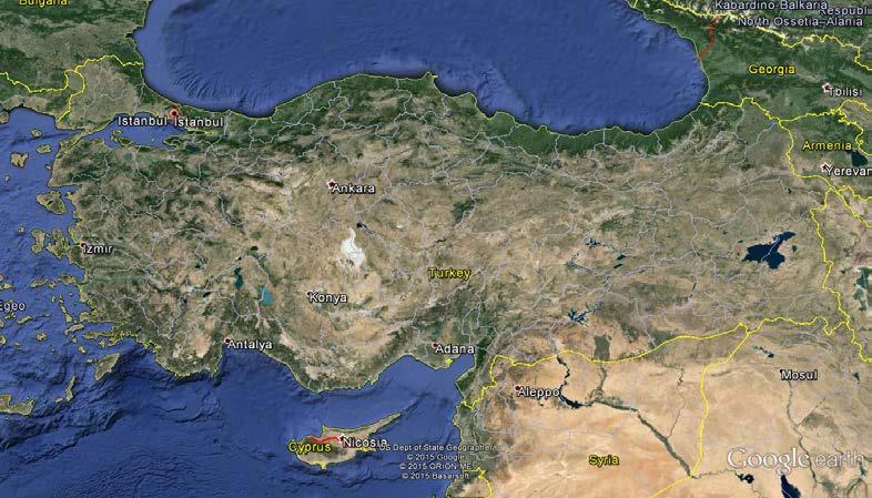
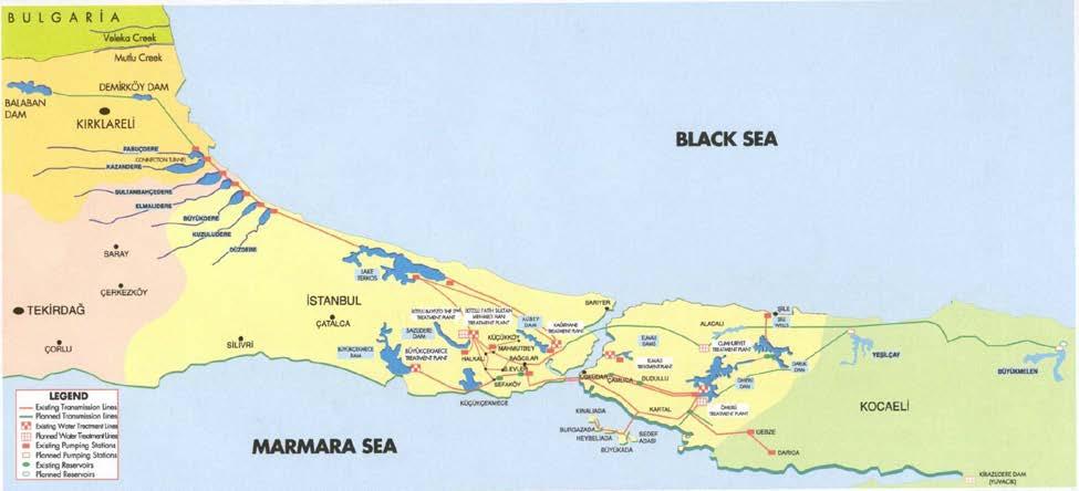
5 Study Area (Istanbul, Turkey) Melen Watershed

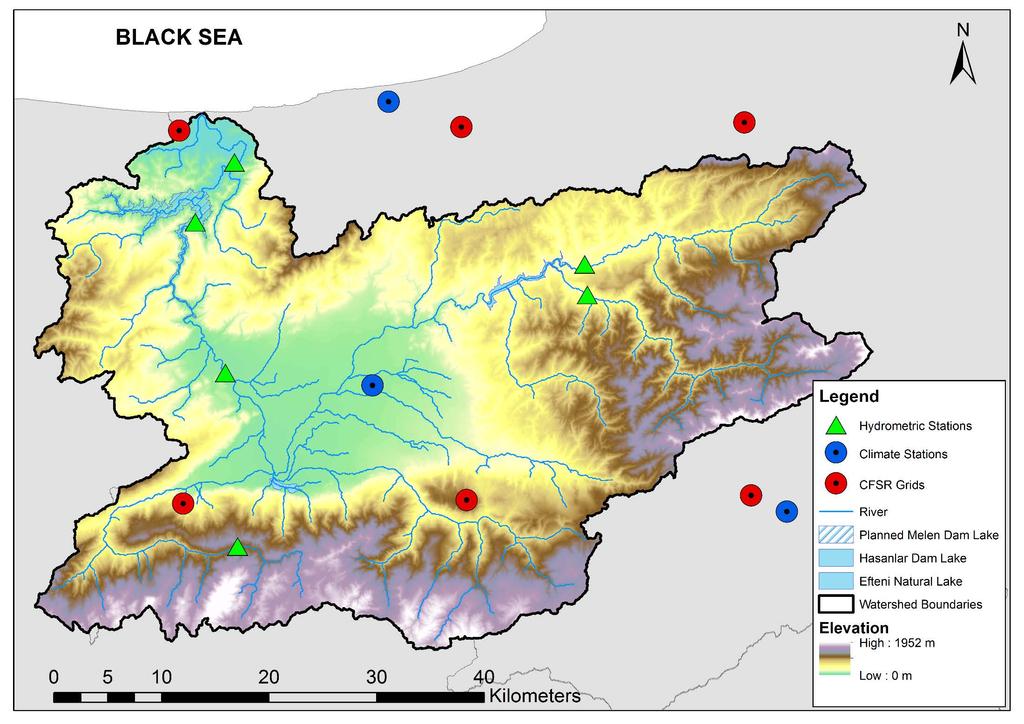
6 Study Area (Melen Watershed) BLACK SEA 188 km SEA OF MARMARA Water Treatment Plant Area = 2444 km 2 Q ave = 45.7 m 3 sec -1 Precip = 823mm??? MELEN WATERSHED
7
8 Model Setup (Data Sources) Digital Elevation Map SRTM 9m Land Use CORINE Soil FAO Climate Data Set CFSR ( ) Local Climate Datasets ( ) Discharge Data DSI (6 stations)
9 Model Setup Simulation period (1995) years warmup 2 Subbasins Hargreaves Method SWAT-CUP using SUFI-2 algorithm 6% of streamflow used for calibration NSE as an objective function Performance criteria NSE, R2, PBIAS as well as P-factor and R-factor


10 Methodology Change Climate Data Land Use Climate Data Soil SWAT Model Setup Preliminary Analysis Evaluation Elevation Band Adj. Evaluation Parameter Adjustment Evaluation Topography Observed Streamflow Re-Setup Model Calibration Complete ArcSWAT SWAT-CUP

11 Climate Data Rainfall (mm) Station Number Rainfall (mm) Arithmetic Avg Station Number Weighted Avg.
12 Discharge Discharge (m3s-1) Discharge (m3s-1) (m3s-1) D13A33 D13A32 E132 D13A38 E13A4 D13A Observed CFSR MGM Observed CFSR MGM Observed CFSR MGM Observed CFSR MGM Observed CFSR MGM
13 Elevation Band Adjustment To consider the orographic effects on precipitation and temperature in watershed, Five elevation bands have been applied to model developed by local data (MGM) Tlapse Rate is chosen as -6.5 C / km Plapse Rate is chosen as 6mm/km
 (m3s-1) 121 127 133 139")
14 Discharge Discharge (m3s-1) Discharge (m3s-1) (m3s-1) D13A32 D13A38 D13A Observed CFSR MGM Observed CFSR MGM Discharge Discharge (m3s-1) (m3s-1) Observed CFSR MGM Discharge (m3s-1) D13A32 D13A38 D13A Observed CFSR MGM (Elev Adj) Observed CFSR MGM (Elev Adj) Observed CFSR MGM (Elev Adj)
15 SWAT Model Parameters CFSR MGM (Elev Adj.) SWAT Parameters Initial Range Final Range r CN2.mgt -.5 to to to.34 r GWQMN.gw -.5 to to to.2 r GW_REVAP.gw -.5 to to to.5 r SOL_AWC().sol -.5 to to to.9 r REVAPMN.gw -.5 to to to.5 r ESCO.hru -.2 to to to.2 r ALPHA_BF.gw -.5 to to to.78 r SOL_K().sol -.5 to to to.28 r SOL_BD().sol -.5 to to to.1 48 simulations has been done

16 Calibration Results Data Set CFSR Station ID Elevation (m) Calibration Validation p-factor r-factor R2 NS PBIAS p-factor r-factor R2 NS PBIAS D13A E13A E13A D13A D13A D13A MGM E13A E13A D13A D13A D13A (Adj. Elev)D13A Moriasi et al. 27 Krause et al. 25 Abbaspour et al. 215
17 Water Budget Components Water Height (mm) *for all basin Water Budget Components* PREP PET ET WYLD SW CFSR MGM U95ppu L95ppu
18 Conclusion Effects of climate data input are investigated using local data (MGM) and CFSR data in Melen Watershed, Turkey. SWAT model has been succesfully applied to quantify water budget components of Melen Watershed. Global freely available gridded reanalysis data (CFSR) represents watershed better than local data (directly used) in Melen Watershed. After using elevation band features of SWAT model for local data, findings of model results has become quite satisfactory at outlet of watershed Model results for both data set in ungauged (climate stations) and mountainous region of watershed still poorly represented. Using different sources of model input (if possible) is very important to define and quantify of unceartinity sources
19 Thanks for your attention...
Application of SWAT for the modelling of sediment yield at Pong reservoir, India
 Application of SWAT for the modelling of sediment yield at Pong reservoir, India A. R. Senthil kumar Tanmoyee Bhattacharya Suhas D Khobragade Manohar Arora National Institute of Hydrology Roorkee-247667,
Simulation of sedimentation rates using the SWAT model A case study of the Tarbela Dam, Upper Indus Basin
 Simulation of sedimentation rates using the SWAT model A case study of the Tarbela Dam, Upper Indus Basin Ahammad, H. I 1., Crosato A 2,3., Maskey, S 2., Masih, I 2,*, McClain, M 2. 1 Punjab Irrigation
Setting up SWAT to quantify water-related ecosystem services in a large East African watershed
 Benedikt Notter, University of Bern, Switzerland Setting up SWAT to quantify water-related ecosystem services in a large East African watershed 5th International SWAT Conference August 5 7, Boulder, Colorado
Danielle A. Bressiani 1, *, R. Srinivasan 2, E. M. Mendiondo 1,3 & K. C. Abbaspour 4
 2015 International SWAT Conference Pula, Sardinia, Italy Danielle A. Bressiani 1, *, R. Srinivasan 2, E. M. Mendiondo 1,3 & K. C. Abbaspour 4 1 Engineering School of São Carlos, University of São Paulo
Uncertainty in the SWAT Model Simulations due to Different Spatial Resolution of Gridded Precipitation Data
 Uncertainty in the SWAT Model Simulations due to Different Spatial Resolution of Gridded Precipitation Data Vamsi Krishna Vema 1, Jobin Thomas 2, Jayaprathiga Mahalingam 1, P. Athira 4, Cicily Kurian 1,
Impact of different types of meteorological data inputs on predicted hydrological and erosive responses to projected land use change
 Impact of different types of meteorological data inputs on predicted hydrological and erosive responses to projected land use change Suman Bhattacharyya 1 & Joy Sanyal * 1 2 1 Department of Geography,
Building a European-wide hydrological model
 Building a European-wide hydrological model 2010 International SWAT Conference, Seoul - South Korea Christine Kuendig Eawag: Swiss Federal Institute of Aquatic Science and Technology Contribution to GENESIS
Climate Change Impact Assessment on Long Term Water Budget for Maitland Catchment in Southern Ontario
 215 SWAT CONFERENCE, PURDUE Climate Change Impact Assessment on Long Term Water Budget for Maitland Catchment in Southern Ontario By Vinod Chilkoti Aakash Bagchi Tirupati Bolisetti Ram Balachandar Contents
Liliana Pagliero June, 15 th 2011
 Liliana Pagliero liliana.pagliero@jrc.ec.europa.eu June, 15 th 2011 2/18 SWAT MODELLING AT PAN EUROPEAN SCALE: THE DANUBE BASIN PILOT STUDY Introduction The Danube Model Available databases Model set up
Hydrological modelling of the Lena River using SWIM
 Hydrological modelling of the Lena River using SWIM Michel Wortmann 1 1 Potsdam Institute for Climate Impact Research (PIK), Germany July 8, 214 Contents 1 The Lena catchment and data used 1 1.1 Discharge
HYDROLOGICAL MODELING OF HIGHLY GLACIERIZED RIVER BASINS. Nina Omani, Raghavan Srinivasan, Patricia Smith, Raghupathy Karthikeyan, Gerald North
 HYDROLOGICAL MODELING OF HIGHLY GLACIERIZED RIVER BASINS Nina Omani, Raghavan Srinivasan, Patricia Smith, Raghupathy Karthikeyan, Gerald North Problem statement Glaciers help to keep the earth cool High
GLACIER AND SNOWMELT MODELLING USING SWAT: GANGA BASIN CASE STUDY. INRM Consultants Pvt. Ltd.
 GLACIER AND SNOWMELT MODELLING USING SWAT: GANGA BASIN CASE STUDY INRM Consultants Pvt. Ltd. Introduction Snowmelt Runoff contribution in the Himalayan Rivers Estimation of Average contribution of Snowmelt
Current and Future Plans. R. Srinivasan
 Current and Future Plans R. Srinivasan Contents 1 The ArcSWAT Interface 2 VizSWAT: Output Visualization 3 User online support 4 MapWindows SWAT interface 5 ArcGIS SWAT/APEX interfaces 6 Radar Rainfall
Comparison of Flow Calibration Using NEXRAD and Surface Rain Gauge Data in ArcSWAT
 Comparison of Flow Calibration Using NEXRAD and Surface Rain Gauge Data in ArcSWAT Presenter: Aisha M. Sexton USDA-ARS-HRSL / UMD Coauthors: Ali Sadeghi, Raghavan Srinivasan, Adel Shirmohammadi, and Xuesong
MODELING SEDIMENT YIELD IN THE SINK CREEK AND PURGATORY CREEK WATERSHEDS NEAR SAN MARCOS, TEXAS. David A. Andresen, B.S.
 MODELING SEDIMENT YIELD IN THE SINK CREEK AND PURGATORY CREEK WATERSHEDS NEAR SAN MARCOS, TEXAS by David A. Andresen, B.S. A thesis submitted to the Graduate Council of Texas State University in partial
Using MODIS imagery to validate the spatial representation of snow cover extent obtained from SWAT in a data-scarce Chilean Andean watershed
 Using MODIS imagery to validate the spatial representation of snow cover extent obtained from SWAT in a data-scarce Chilean Andean watershed Alejandra Stehr 1, Oscar Link 2, Mauricio Aguayo 1 1 Centro
A large scale and fine resolution SWAT model for an assessment of isolated climate change impact on unaltered flow regimes in Central Eastern Europe
 A large scale and fine resolution SWAT model for an assessment of isolated climate change impact on unaltered flow regimes in Central Eastern Europe Mikołaj Piniewski 1,2, Mateusz Szcześniak 2, Tomasz
The 2 nd Annual Gobeshona Conference Future Changes of Flash Flood in the North East Region of Bangladesh using HEC-HMS Modeling
 The 2 nd Annual Gobeshona Conference 2016 Future Changes of Flash Flood in the North East Region of Bangladesh using HEC-HMS ing By- Shammi Haque 1*, Mutasim Billah 1, Afiya Narzis 2, A.K.M. Saiful Islam
Setting up SWAT for the Upper Amazon
 2014 International SWAT Conference Setting up SWAT for the Upper Amazon Michael Strauch, Martin Volk 2014 International SWAT Conference Porto de Galinhas, July 30 August 1, 2014 ISI-MIP2 Inter-Sectoral
Improved ensemble representation of soil moisture in SWAT for data assimilation applications
 Improved ensemble representation of soil moisture in SWAT for data assimilation applications Amol Patil and RAAJ Ramsankaran Hydro-Remote Sensing Applications (H-RSA) Group, Department of Civil Engineering
Detroit 516 Activities
 Detroit 516 Activities Dam Capacity Study Sediment Workshop in Traverse City START 2.0 Saginaw River Study Dam Capacity Study A progress report Outline Study Objective (Why are we doing this?) Reservoir
Assessment of solid load and siltation potential of dams reservoirs in the High Atlas of Marrakech (Moorcco) using SWAT Model
 using SWAT Model") Assessment of solid load and siltation potential of dams reservoirs in the High Atlas of Marrakech (Moorcco) using SWAT Model Amal Markhi: Phd Student Supervisor: Pr :N.Laftrouhi Contextualization Facing
Assessment of solid load and siltation potential of dams reservoirs in the High Atlas of Marrakech (Moorcco) using SWAT Model Amal Markhi: Phd Student Supervisor: Pr :N.Laftrouhi Contextualization Facing
Hydrologic Modelling of the Upper Malaprabha Catchment using ArcView SWAT
 Hydrologic Modelling of the Upper Malaprabha Catchment using ArcView SWAT Technical briefs are short summaries of the models used in the project aimed at nontechnical readers. The aim of the PES India
ESTIMATION OF DISCHARGE FOR UNGAUGED CATCHMENTS USING RAINFALL-RUNOFF MODEL IN DIDESSA SUB-BASIN: THE CASE OF BLUE NILE RIVER BASIN, ETHIOPIA.
 ESTIMATION OF DISCHARGE FOR UNGAUGED CATCHMENTS USING RAINFALL-RUNOFF MODEL IN DIDESSA SUB-BASIN: THE CASE OF BLUE NILE RIVER BASIN, ETHIOPIA. CHEKOLE TAMALEW Department of water resources and irrigation
Modelling Runoff with Satellite Data. Nyandwaro Gilbert Nyageikaro Patrick Willems Joel Kibiiy
 Modelling Runoff with Satellite Data Nyandwaro Gilbert Nyageikaro Patrick Willems Joel Kibiiy 1 Outline Background information SWAT model development The model sensitivity analysis and calibration Calibration
DEVELOPMENT AND APPLICATION OF A HYDROCLIMATOLOGICAL STREAM TEMPERATURE MODEL WITHIN SWAT
 DEVELOPMENT AND APPLICATION OF A HYDROCLIMATOLOGICAL STREAM TEMPERATURE MODEL WITHIN SWAT Darren L. Ficklin 1, Yuzhou Luo 2, Iris T. Stewart 1, Edwin P. Maurer 3 1 Environmental Studies Institute, Santa
Modeling the Effects of Climate and Land Cover Change in the Stoney Brook Subbasin of the St. Louis River Watershed
 Modeling the Effects of Climate and Land Cover Change in the Stoney Brook Subbasin of the St. Louis River Watershed Joe Johnson and Jesse Pruette 214 NASA Research Internship Geospatial Technologies Program
Evaluation of the SWAT Model Setup Process Through A Case Study in Roxo Catchment, Portugal
 Evaluation of the SWAT Model Setup Process Through A Case Study in Roxo Catchment, Portugal Mustafa Gökmen Master Degree in on Geo-information and Earth Observation for Integrated Catchment and Water Resources
Floodplain modeling. Ovidius University of Constanta (P4) Romania & Technological Educational Institute of Serres, Greece
 Romania & Technological Educational Institute of Serres, Greece") Floodplain modeling Ovidius University of Constanta (P4) Romania & Technological Educational Institute of Serres, Greece Scientific Staff: Dr Carmen Maftei, Professor, Civil Engineering Dept. Dr Konstantinos
Floodplain modeling Ovidius University of Constanta (P4) Romania & Technological Educational Institute of Serres, Greece Scientific Staff: Dr Carmen Maftei, Professor, Civil Engineering Dept. Dr Konstantinos
MODULE 8 LECTURE NOTES 2 REMOTE SENSING APPLICATIONS IN RAINFALL-RUNOFF MODELLING
 MODULE 8 LECTURE NOTES 2 REMOTE SENSING APPLICATIONS IN RAINFALL-RUNOFF MODELLING 1. Introduction The most common application of the remote sensing techniques in the rainfall-runoff studies is the estimation
Modeling Upland and Channel Sources of Sediment in the Le Sueur River Watershed, Minnesota
 Modeling Upland and Channel Sources of Sediment in the Le Sueur River Watershed, Minnesota Solomon Folle and David Mulla Department of Soil, Water and Climate University of Minnesota August 6, 2009 5 th
How to integrate wetland processes in river basin modeling? A West African case study
 How to integrate wetland processes in river basin modeling? A West African case study stefan.liersch@pik-potsdam.de fred.hattermann@pik-potsdam.de June 2011 Outline Why is an inundation module required?
Modelling changes in the runoff regime in Slovakia using high resolution climate scenarios
 Modelling changes in the runoff regime in Slovakia using high resolution climate scenarios K. HLAVČOVÁ, R. VÝLETA, J. SZOLGAY, S. KOHNOVÁ, Z. MACUROVÁ & P. ŠÚREK Department of Land and Water Resources
Basin characteristics
 Basin characteristics From hydrological processes at the point scale to hydrological processes throughout the space continuum: point scale à river basin The watershed characteristics (shape, length, topography,
Automatic Watershed Delineation using ArcSWAT/Arc GIS
 Automatic Watershed Delineation using ArcSWAT/Arc GIS By: - Endager G. and Yalelet.F 1. Watershed Delineation This tool allows the user to delineate sub watersheds based on an automatic procedure using
Appendix D. Model Setup, Calibration, and Validation
 . Model Setup, Calibration, and Validation Lower Grand River Watershed TMDL January 1 1. Model Selection and Setup The Loading Simulation Program in C++ (LSPC) was selected to address the modeling needs
INTRODUCTION TO HEC-HMS
 INTRODUCTION TO HEC-HMS Hydrologic Engineering Center- Hydrologic Modeling System US Army Corps of Engineers Hydrologic Engineering Center HEC-HMS Uses Schematics Enter properties: watershed, rivers (reaches),
HYDROLOGICAL MODELLING OF COOUM RIVER BASIN USING GIS AND SWAT MODEL
 HYDROLOGICAL MODELLING OF COOUM RIVER BASIN USING GIS AND SWAT MODEL Sravani Duvvuri Assistant Professor in Civil Engineering Rajiv Gandhi University of Knowledge Technologies, IIIT Nuzvid, Quarter No:
IMPACT OF CLIMATE CHANGE OVER THE ARABIAN PENINSULA
 IMPACT OF CLIMATE CHANGE OVER THE ARABIAN PENINSULA By: Talal Alharbi June, 29 2017 1 Motivation: In arid and semi-arid regions of the world the demand for fresh water resources is increasing due to: increasing
Quantifying Uncertainty in Modelled Estimates of Future Extreme Precipitation Events CFCAS Project Progress Report
 Quantifying Uncertainty in Modelled Estimates of Future Extreme Precipitation Events CFCAS Project Progress Report The University of Western Ontario Outline A - Reanalysis Data for UTRW C Quantifying GCM
STREAM FLOW MODELING IN THE NACUNDAY RIVER BASIN (PARAGUAY, SOUTH AMERICA) USING SWAT MODEL. Sandra Mongelos and Manoj K. Jain
 USING SWAT MODEL. Sandra Mongelos and Manoj K. Jain") STREAM FLOW MODELING IN THE NACUNDAY RIVER BASIN (PARAGUAY, SOUTH AMERICA) USING SWAT MODEL Sandra Mongelos and Manoj K. Jain DEPARTMENT OF HYDROLOGY INDIAN INSTITUTE OF TECHNOLOGY ROORKEE ROORKEE 247
STREAM FLOW MODELING IN THE NACUNDAY RIVER BASIN (PARAGUAY, SOUTH AMERICA) USING SWAT MODEL Sandra Mongelos and Manoj K. Jain DEPARTMENT OF HYDROLOGY INDIAN INSTITUTE OF TECHNOLOGY ROORKEE ROORKEE 247
Lake Tahoe Watershed Model. Lessons Learned through the Model Development Process
 Lake Tahoe Watershed Model Lessons Learned through the Model Development Process Presentation Outline Discussion of Project Objectives Model Configuration/Special Considerations Data and Research Integration
Abebe Sine Gebregiorgis, PhD Postdoc researcher. University of Oklahoma School of Civil Engineering and Environmental Science
 Abebe Sine Gebregiorgis, PhD Postdoc researcher University of Oklahoma School of Civil Engineering and Environmental Science November, 2014 MAKING SATELLITE PRECIPITATION PRODUCTS WORK FOR HYDROLOGIC APPLICATION
Flash Flood Flash Flood Forecasting and Early Warning System (FFEWS)
") Stakeholder Workshop of Haor Area Livelihoods Improvement Project (HALIP) 15 January 2016, Sunamganj, Bangladesh Flash Flood Flash Flood Forecasting and Early Warning System (FFEWS) BUET Study Team Prof
Stakeholder Workshop of Haor Area Livelihoods Improvement Project (HALIP) 15 January 2016, Sunamganj, Bangladesh Flash Flood Flash Flood Forecasting and Early Warning System (FFEWS) BUET Study Team Prof
CHAPTER VII FULLY DISTRIBUTED RAINFALL-RUNOFF MODEL USING GIS
 80 CHAPTER VII FULLY DISTRIBUTED RAINFALL-RUNOFF MODEL USING GIS 7.1GENERAL This chapter is discussed in six parts. Introduction to Runoff estimation using fully Distributed model is discussed in first
Near Real-Time Runoff Estimation Using Spatially Distributed Radar Rainfall Data. Jennifer Hadley 22 April 2003
 Near Real-Time Runoff Estimation Using Spatially Distributed Radar Rainfall Data Jennifer Hadley 22 April 2003 Introduction Water availability has become a major issue in Texas in the last several years,
Analyzing spatial and temporal variation of water balance components in La Vi catchment, Binh Dinh province, Vietnam
 Analyzing spatial and temporal variation of water balance components in La Vi catchment, Binh Dinh province, Vietnam Nguyen Duy Liem, Vo Ngoc Quynh Tram, Nguyen Le Tan Dat, Nguyen Kim Loi Nong Lam University-
Introduction to the new modular SWAT code: The input file structure explained using the example of the Little River Experimental Watershed, USA
 Introduction to the new modular SWAT code: The input file structure explained using the example of the Little River Experimental Watershed, USA Katrin Bieger and Jeffrey G. Arnold 2014 International SWAT
VIC Hydrology Model Training Workshop Part II: Building a model
 VIC Hydrology Model Training Workshop Part II: Building a model 11-12 Oct 2011 Centro de Cambio Global Pontificia Universidad Católica de Chile Ed Maurer Civil Engineering Department Santa Clara University
Influence of rainfall space-time variability over the Ouémé basin in Benin
 102 Remote Sensing and GIS for Hydrology and Water Resources (IAHS Publ. 368, 2015) (Proceedings RSHS14 and ICGRHWE14, Guangzhou, China, August 2014). Influence of rainfall space-time variability over
Flash Flood Guidance System On-going Enhancements
 Flash Flood Guidance System On-going Enhancements Hydrologic Research Center, USA Technical Developer SAOFFG Steering Committee Meeting 1 10-12 July 2017 Jakarta, INDONESIA Theresa M. Modrick Hansen, PhD
Asim Jahangir Khan, Doctoral Candidate, Department of Geohydraulics and Engineering Hydrology, University of Kassel, Germany
 Correction and informed Regionalization of Precipitation Data in a high mountainous Region (Upper Indus Basin) and its Effect on SWAT-modelled Discharge Asim Jahangir Khan, Doctoral Candidate, Department
THE RAINWATER HARVESTING SYMPOSIUM 2015
 THE RAINWATER HARVESTING SYMPOSIUM 2015 Remote Sensing for Rainwater Harvesting and Recharge Estimation under Data Scarce Conditions Taye Alemayehu Ethiopian Institute of Water Resources, Metameta Research
July, International SWAT Conference & Workshops
 July, 212 212 International SWAT Conference & Workshops Hydrological Modelling of Kosi and Gandak Basins using SWAT Model S. Dutta, Pritam Biswas, Sangita Devi, Suresh A Karth and Bimlesh kumar, Ganga
Dr. S.SURIYA. Assistant professor. Department of Civil Engineering. B. S. Abdur Rahman University. Chennai
 Hydrograph simulation for a rural watershed using SCS curve number and Geographic Information System Dr. S.SURIYA Assistant professor Department of Civil Engineering B. S. Abdur Rahman University Chennai
Modeling of a River Basin Using SWAT Model and SUFI-2
 Modeling of a River Basin Using SWAT Model and SUFI-2 NINA OMANI MASOUD TAJRISHY AHMAD ABRISHAMCHI Sharif University of Technology, Tehran, Iran Karkheh Dam, Iran 1 Area of Gharasu Sub-basin : 5793 km2
Rainfall-runoff modelling using merged rainfall from radar and raingauge measurements
 Rainfall-runoff modelling using merged rainfall from radar and raingauge measurements Nergui Nanding, Miguel Angel Rico-Ramirez and Dawei Han Department of Civil Engineering, University of Bristol Queens
Use of SWAT to Scale Sediment Delivery from Field to Watershed in an Agricultural Landscape with Depressions
 Use of SWAT to Scale Sediment Delivery from Field to Watershed in an Agricultural Landscape with Depressions James E. Almendinger St. Croix Watershed Research Station, Science Museum of Minnesota Marylee
12 SWAT USER S MANUAL, VERSION 98.1
 12 SWAT USER S MANUAL, VERSION 98.1 CANOPY STORAGE. Canopy storage is the water intercepted by vegetative surfaces (the canopy) where it is held and made available for evaporation. When using the curve
Modification of global precipitation data for enhanced hydrologic modeling of tropical montane watersheds
 Modification of global precipitation data for enhanced hydrologic modeling of tropical montane watersheds Michael Strauch, Rohini Kumar, Stephanie Eisner, Mark Mulligan, Julia Reinhardt, William Santini,
Tropics & Sub-Tropics. How can predictive approaches be improved: Data Sparse Situations
 Tropics & Sub-Tropics How can predictive approaches be improved: Data Sparse Situations 1. Protocol for catchment function diagnostics and model setup. Use of a decision tree as a preliminary stage to
WaterBase: SWAT in an Open Source GIS
 WaterBase: SWAT in an Open Source GIS C. George 1 and L.F. Leon*,2 The Open Hydrology Journal, 2008, 2, 1-6 1 1 International Institute for Software Technology, United Nations University, Macao, China
Quantifying uncertainty in large-scale hydrological model inputs
 Hydropredict Wien 2012 Quantifying uncertainty in large-scale hydrological model inputs At what scale can we make predictions? Chantal Donnelly: Swedens Meteorological and Hydrological Institute, chantal.donnelly@smhi.se
Flood Forecasting Tools for Ungauged Streams in Alberta: Status and Lessons from the Flood of 2013
 Flood Forecasting Tools for Ungauged Streams in Alberta: Status and Lessons from the Flood of 2013 John Pomeroy, Xing Fang, Kevin Shook, Tom Brown Centre for Hydrology, University of Saskatchewan, Saskatoon
IMPACT OF PROJECTED CLIMATE CHANGE ON SEDIMENT YIELD IN THE CHALIYAR RIVER BASIN
 1 IMPACT OF PROJECTED CLIMATE CHANGE ON SEDIMENT YIELD IN THE CHALIYAR RIVER BASIN ANSA THASNEEM S, SANTOSH G THAMPI & CHITHRA. N. R. NIT Calicut, Kozhikode, Kerala, India e-mail: ansathsnm@gmail.com,santosh@nitc.ac.in,
Spatial Downscaling of TRMM Precipitation Using DEM. and NDVI in the Yarlung Zangbo River Basin
 Spatial Downscaling of TRMM Precipitation Using DEM and NDVI in the Yarlung Zangbo River Basin Yang Lu 1,2, Mingyong Cai 1,2, Qiuwen Zhou 1,2, Shengtian Yang 1,2 1 State Key Laboratory of Remote Sensing
Introduction to HEC-GeoHMS. Watershed boundary delineation. Assembling Hydrologic Modeling System
 Introduction to HEC-GeoHMS Watershed boundary delineation Assembling Hydrologic Modeling System HEC-GeoHMS GIS tool set supporting HEC-HMS modeling S Developed by USACE S ArcView 3.x extension v1.1 supported
Geography 415 Hydrology
 1 Geography 415 Hydrology LAB 1 (January 23, 2003) TA: Drew Lejbak Office: ES 310, 220-5590, atlejbak@ucalgary.ca Hours: Friday 10:00am 12:00pm, or by appointment Drop Box: Outside ES 313 1. Estimation
Application of SWAT Model to Estimate the Runoff and Sediment Load from the Right Bank Valleys of Mosul Dam Reservoir
 Application of SWAT Model to Estimate the Runoff and Sediment Load from the Right Bank Valleys of Mosul Dam Reservoir Dr Mohammad Ezeel Deen Prof. Nadhir Al-Ansari Prof Sven Knutsson Figure 1.Map of Iraq
GIS model & modeling
 GIS model & modeling Model : a simplified representation of a phenomenon or a system. GIS modeling : the use of GIS in the process of building models with spatial data. Basic requirement in modeling :
Raktim Haldar Research Scholar Department of Civil Engineering Indian Institute of Technology, Delhi
 Raktim Haldar Research Scholar Department of Civil Engineering Indian Institute of Technology, Delhi Issues to be addressed Introduction to the Vembanad Lake and surrounding scenario of development Anthropogenic
Assessing bias in satellite rainfall products and their impact in water balance closure at the Zambezi headwaters
 Assessing bias in satellite rainfall products and their impact in water balance closure at the Zambezi headwaters Omondi C.K. 1 Rientjes T.H.M. 1, Haile T.A. 2, Gumindoga W. 1,3 (1) Faculty ITC, University
9. PROBABLE MAXIMUM PRECIPITATION AND PROBABLE MAXIMUM FLOOD
 9. PROBABLE MAXIMUM PRECIPITATION AND PROBABLE MAXIMUM FLOOD 9.1. Introduction Due to the size of Watana Dam and the economic importance of the Project to the Railbelt, the Probable Maximum Flood (PMF)
Modelling Annual Suspended Sediment Yields in Irish River Catchments
 Modelling Annual Suspended Sediment Yields in Irish River Catchments Rymszewicz, A., Bruen, M., O Sullivan, J.J., Turner, J.N., Lawler, D.M., Harrington, J., Conroy, E., Kelly-Quinn, M. SILTFLUX Project
Simulation of hydrologic and water quality processes in watershed systems using linked SWAT-MODFLOW-RT3D model
 Simulation of hydrologic and water quality processes in watershed systems using linked model Ryan Bailey, Assistant Professor Xiaolu Wei, PhD student Rosemary Records, PhD student Mazdak Arabi, Associate
Erosion modelling in the upper Blue Nile basin: The case of Mizewa watershed in Ethiopia
 Erosion modelling in the upper Blue Nile basin: The case of Mizewa watershed in Ethiopia Citation: Assegahegn, M.A. and Zemadim, B. Erosion modelling in the upper Blue Nile basin: The case of Mizewa watershed
SWAT 2015 International Conference:
 SWAT 2015 International Conference: Comparative Analysis of Spatial Resolution Effects on Standard and Grid-based SWAT Models Presented by: Garett Pignotti Co-authors: Dr. Hendrik Rathjens, Dr. Cibin Raj,
Conservation Planning evaluate land management alternatives to reduce soil erosion to acceptable levels. Resource Inventories estimate current and
 Conservation Planning evaluate land management alternatives to reduce soil erosion to acceptable levels. Resource Inventories estimate current and projected erosion levels and their impact on natural resource
Geog Lecture 19
 Geog 1000 - Lecture 19 Fluvial Geomorphology and River Systems http://scholar.ulethbridge.ca/chasmer/classes/ Today s Lecture (Pgs 346 355) 1. What is Fluvial Geomorphology? 2. Hydrology and the Water
Under the guidance of Prof.C S P Ojha
 A Presentation by KAUSHIKA G S Under the guidance of Prof.C S P Ojha HYDRAULICS ENGINEERING GROUP DEPARTMENT OF CIVIL ENGINEERING INDIAN INSTITUTE OF TECHNOLOGY ROORKEE ROORKEE 247 667, Uttarakhand, INDIA
Re-dimensioned CFS Reanalysis data for easy SWAT initialization
 Re-dimensioned CFS Reanalysis data for easy SWAT initialization Daniel R Fuka, Charlotte MacAlister, Solomon Seyoum, Allan Jones, Raghavan Srinivasan Cornell University IWMI East Africa Texas A&M Re-dimensioned
Hydrologic and Water Quality Modeling for the Missouri River Basin (MORB)
") 2016 International SWAT Conference in Beijing, China Hydrologic and Water Quality Modeling for the Missouri River Basin (MORB) Zhonglong Zhang, PhD, PE, May Wu, PhD Courtesy of USACE Outline Missouri River
2016 International SWAT Conference in Beijing, China Hydrologic and Water Quality Modeling for the Missouri River Basin (MORB) Zhonglong Zhang, PhD, PE, May Wu, PhD Courtesy of USACE Outline Missouri River
Climate Change Impact Assessment on Indian Water Resources. Ashvin Gosain, Sandhya Rao, Debajit Basu Ray
 Climate Change Impact Assessment on Indian Water Resources Ashvin Gosain, Sandhya Rao, Debajit Basu Ray Objectives of the Study To quantify the impact of the climate change on the water resources of the
RR#5 - Free Response
 Base your answers to questions 1 through 3 on the data table below and on your knowledge of Earth Science. The table shows the area, in million square kilometers, of the Arctic Ocean covered by ice from
ENGINEERING HYDROLOGY
 ENGINEERING HYDROLOGY Prof. Rajesh Bhagat Asst. Professor Civil Engineering Department Yeshwantrao Chavan College Of Engineering Nagpur B. E. (Civil Engg.) M. Tech. (Enviro. Engg.) GCOE, Amravati VNIT,
Modified temperature index model for estimating the melt water discharge from debris-covered Lirung Glacier, Nepal
 Remote Sensing and GIS for Hydrology and Water Resources (IAHS Publ. 368, 2015) (Proceedings RSHS14 and ICGRHWE14, Guangzhou, China, August 2014). 409 Modified temperature index model for estimating the
7 Flood Prediction in Japan and the Need for Guidelines for Flood Runoff Modelling
 7 Flood Prediction in Japan and the Need for Guidelines for Flood Runoff Modelling YASUTO TACHIKAWA, ROSHAN K. SHRESTHA & TAKAHIRO SAYAMA FLOOD DISASTER AND FLOOD RUNOFF MODELLING IN JAPAN About 5% of
MODELING STUDIES WITH HEC-HMS AND RUNOFF SCENARIOS IN YUVACIK BASIN, TURKIYE
 MODELING STUDIES WITH HEC-HMS AND RUNOFF SCENARIOS IN YUVACIK BASIN, TURKIYE Yener, M.K. Şorman, A.Ü. Department of Civil Engineering, Middle East Technical University, 06531 Ankara/Türkiye Şorman, A.A.
Evaluation of the two stage ditch as a best management practice. A. Hodaj, L.C. Bowling, C. Raj, I. Chaubey
 Evaluation of the two stage ditch as a best management practice A. Hodaj, L.C. Bowling, C. Raj, I. Chaubey Two-stage ditch: Stage 1 : main channel Stage 2 : flood plain bench Traditional ditch Twostage
Integration of TUSLE in SWAT model for sediment prediction at a small mountainous catchment,chenyulan watershed,taiwan
 Integration of TUSLE in SWAT model for sediment prediction at a small mountainous catchment,chenyulan watershed,taiwan Presenter : Chih-Mei Lu Authors : Chih-Mei Lu, Li-Chi Chiang * Department of Civil
GIS in Water Resources Midterm Exam Fall 2008 There are 4 questions on this exam. Please do all 4.
 Page 1 of 8 Name: GIS in Water Resources Midterm Exam Fall 2008 There are 4 questions on this exam. Please do all 4. 1. Basic Concepts [20 points] Find the letter with the best answer for each term: 1.
A GIS-based Approach to Watershed Analysis in Texas Author: Allison Guettner
 Texas A&M University Zachry Department of Civil Engineering CVEN 658 Civil Engineering Applications of GIS Instructor: Dr. Francisco Olivera A GIS-based Approach to Watershed Analysis in Texas Author:
Application of the SWAT hydrological model in a small, mountainous catchment in South Africa
 Application of the SWAT hydrological model in a small, mountainous catchment in South Africa by Kimberley Anne Perry Submitted in partial fulfilment of the requirements for the degree MASTER OF SCIENCE
Changing Hydrology under a Changing Climate for a Coastal Plain Watershed
 Changing Hydrology under a Changing Climate for a Coastal Plain Watershed David Bosch USDA-ARS, Tifton, GA Jeff Arnold ARS Temple, TX and Peter Allen Baylor University, TX SEWRU Objectives 1. Project changes
Simulating hydrological processes in a sub-basin of the Mekong using GBHM and RS data
 Remote Sensing and GIS for Hydrology and Water Resources (IAHS Publ. 368, 2015) (Proceedings RSHS14 and ICGRHWE14, Guangzhou, China, August 2014). 221 Simulating hydrological processes in a sub-basin of
Sediment management modelling in the Blue Nile Basin using SWAT model
 0 0 Sediment management modelling in the Blue Nile Basin using SWAT model Getnet D. Betrie,, Yasir. A. Mohamed,, A. van Griensven, Raghavan Srinivasan, and A. Mynett,, []UNESCO-IHE Institute for Water
Climate Change Impacts on Glaciers and Runoff in Alpine catchments
 Climate Change Impacts on Glaciers and Runoff in Alpine catchments Saeid A. Vaghefi Eawag: Swiss Federal Institute of Aquatic Science and Technology University of Geneva, Institute for Environmental Science
Uncertainty analysis of nonpoint source pollution modeling:
 2013 SWAT Conference Uncertainty analysis of nonpoint source pollution modeling: An important implication for Soil and Water Assessment Tool Professor Zhenyao Shen 2013-07-17 Toulouse Contents 1 2 3 4
Spatial representation of evapotranspiration in the Mara basin: results derived from the SWAT model and remote sensing products
 Spatial representation of evapotranspiration in the Mara basin: results derived from the SWAT model and remote sensing products Alemayehu, T 1., van Griensven, A. 1,2, Kilonzo, F. 1,2, and Bauwens, W.
Operational water balance model for Siilinjärvi mine
 Operational water balance model for Siilinjärvi mine Vesa Kolhinen, Tiia Vento, Juho Jakkila, Markus Huttunen, Marie Korppoo, Bertel Vehviläinen Finnish Environment Institute (SYKE) Freshwater Centre/Watershed