Setting up SWAT for the Upper Amazon
|
|
|
- Laurence Owens
- 5 years ago
- Views:
Transcription


1 2014 International SWAT Conference Setting up SWAT for the Upper Amazon Michael Strauch, Martin Volk 2014 International SWAT Conference Porto de Galinhas, July 30 August 1, 2014


2 ISI-MIP2 Inter-Sectoral Impact Model Integration and Intercomparison Project community-driven modelling effort bringing together impact models across sectors and scales to create consistent and comprehensive projections of the impacts of different levels of global warming coordinated by Focus regions ISI-MIP Framework: Common set of input data Common modelling protocol Central output data archive SEITE 2
 Soil Harmonized World Soil Database, Version 1.2, SOL_K calc. using ROSETTA (Schaap et al.")
 Climate WFD ERA 40 (Weedon et al.")
3 Input data DEM Data source HydroSHEDS (SRTM, 90 m, hydrol. conditioned, Lehner et al. 2008) Soil Harmonized World Soil Database, Version 1.2, SOL_K calc. using ROSETTA (Schaap et al., 2001) Land use GLC2000 product South America (Eva et al., 2002) Climate WFD ERA 40 (Weedon et al., 2010) Calibration/validation Global Runoff Data Centre (GRDC), Hidroweb ( SEITE 3

 1.")
4 Digital Elevation Model SRTM 90 m, hydrologically conditioned Hydrological data and maps based on SHuttle Elevation Derivatives at multiple Scales (Lehner et al., 2008) 1.02 mio km 2 SEITE 4


5 Streamflow data Global Runoff Data Centre 1.02 mio km 2 SEITE 5
6 Subbasin delineation Based on suggested minimum size: 719,600 ha 82 subbasins (Ø 12,500 km²) too large for physically meaningful Muskingum routing??? 1.02 mio km 2 SEITE 6


7 Land use 39 GLC classes aggregated to 16 SWAT classes Global Land Cover 2000 product South America (Eva et al., 2002) SEITE 7

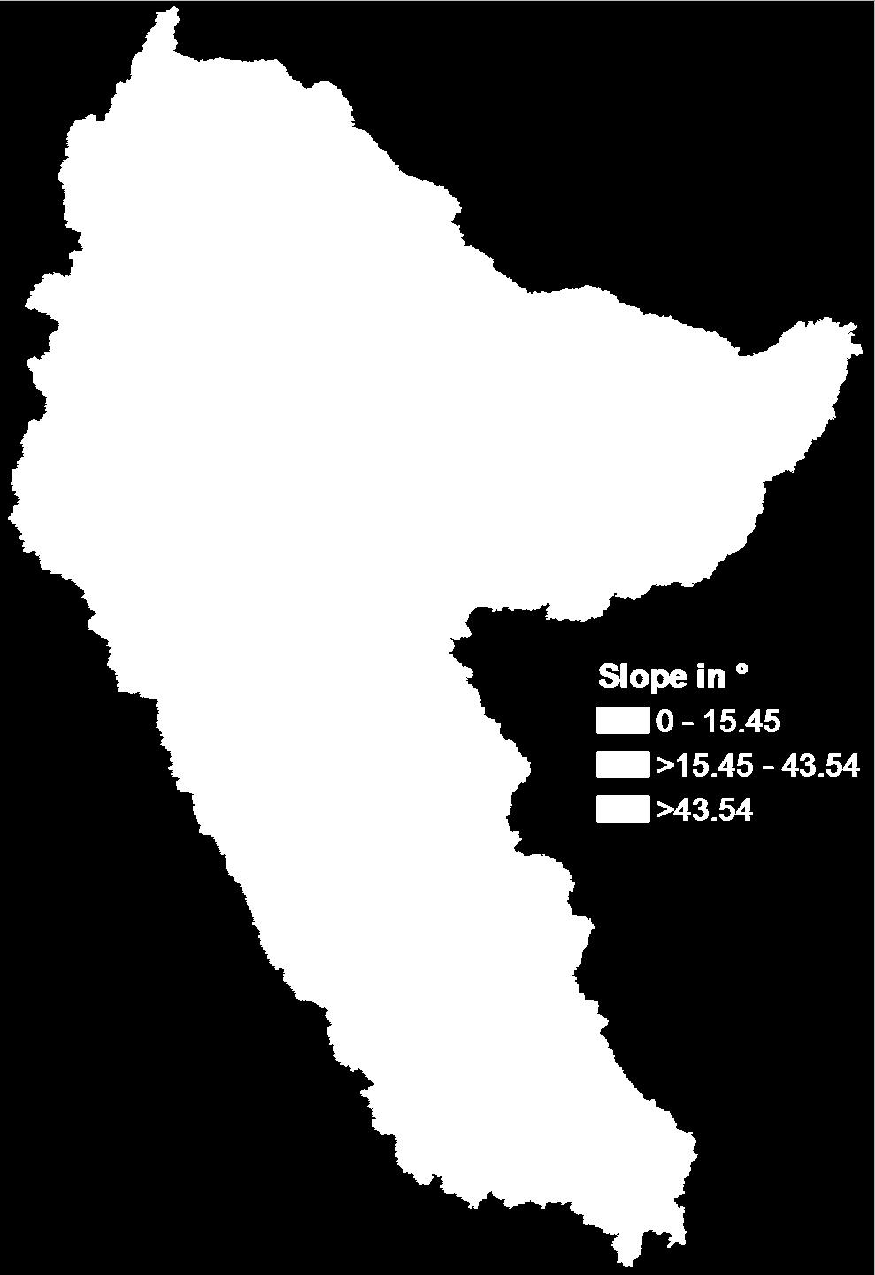
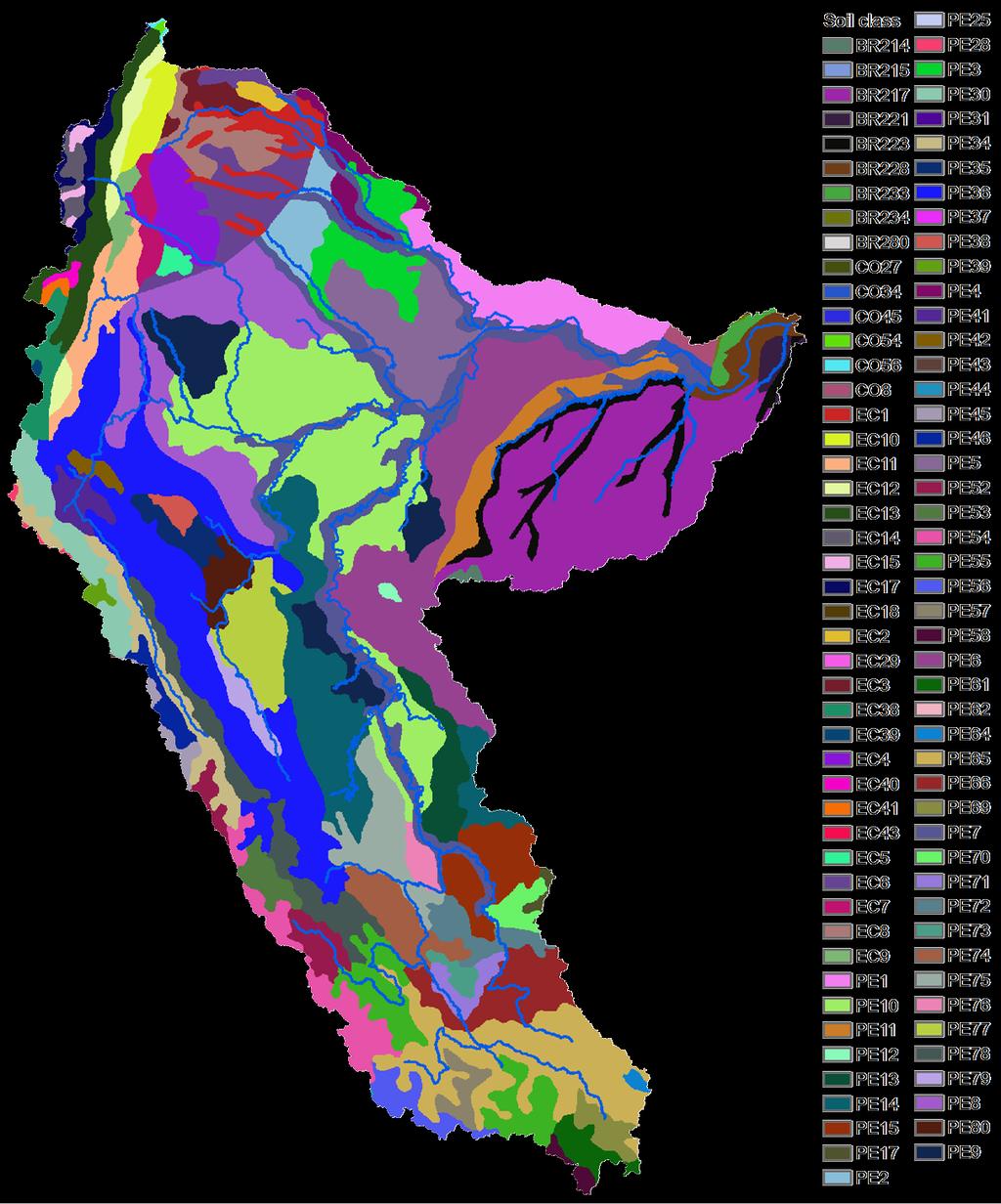
8 Soils Harmonized World Soil Database, Version 1.2 SEITE 8 Slope
9 HRU definition by error analysis Each dot represents a certain threshold set for land use / soil / slope We chose: / / [ha] RTE: Relative Total Error (of land use, soil, and slope distribution compared to full HRU map) remaining number of HRUs: 999 SEITE 9
, daily for time period 1/1/1958 31/12/2001")
 Wind speed (in m/s) Solar radiation")
 Weedon et al. (2010) SEITE 10")
10 Weather data WFD WATCH Forcing Data (Basis ERA 40), daily for time period 1/1/ /12/2001 Temperature (max, min in K) Precipitation (in kg/m²/s) Wind speed (in m/s) Solar radiation (in W/m²) Specific humidity (in kg/kg) Surface pressure (in Pa) Weedon et al. (2010) SEITE 10

 *Seasonal pattern")

11 Model calibration: Plant growth Time of NDVI peaks (Brando et al., 2010) SWAT*-LAI simulations (for all HRUs of a certain land use) *Seasonal pattern depending on latitude & soil moisture using the modified SWAT version for tropics! (Strauch & Volk, 2013) SEITE 11
 ET")
 Borja ET (P-R, mm) SEITE 12 97")


12 Model calibration: Water balance ( ) São Paulo de Olivença Borja Pcp observed São P. O. R (mm) ET (P-R, mm) observed sim initial sim elevb R (mm) Borja ET (P-R, mm) SEITE observed sim initial sim elevb However, elevation bands not justified for the type of data used in this study. What to do? Pcp using elevation bands (changes in mm) e. b. from DEM PLAPS: 500 mm/km TLAPS: -8 C/km
13 Model calibration Multi-site autocalibration Latin-Hypercube sampling (n=3000) 32 parameters (5 basin wide regional parameters) Best solution defined by minimum rank sum of 11 performance metrics over all three calibration gauges Uncertainty interval (UI) by considering as many (sorted) solutions as necessary that: width UI = σ obs SEITE 13
14 Model evaluation Rank sum of 11 performance metrics over three gauges PBIAS NSE mnse rnse d md rd cp br2 KGE VE Percent Bias Nash-Sutcliff Efficiency Modified Nash-Sutcliff Efficiency Relative Nash-Sutcliff Efficiency Index of Agreement Modified Index of Agreement Relative Index of Agreement Persistence Index R² multiplied by coefficient of regression line between sim and obs Kling-Gupta Efficiency Volumetric Efficiency SEITE 14
15 Borja NSE = 0.52 PBIAS = 3.5% d-factor = 1.11 POC = 61% Tamishiyacu NSE = 0.63 PBIAS = -4.8% d-factor = 1.01 POC = 59% Calibration Based on wrong assumptions (elevation bands), need to calibrate again São Paulo de O. NSE = 0.78 PBIAS = 8.8% d-factor = 0.51 POC = 43% Months in period SEITE 15


16 Borja NSE = 0.65 PBIAS = -3.5% Validation Tamishiyacu NSE = 0.51 PBIAS = -13.5% Based on wrong assumptions (elevation bands), need to calibrate again São Paulo de O. NSE = 0.89 PBIAS = 4% Months in period SEITE 16
, need to calibrate again Tabatinga NSE = 0.84 PBIAS = 0.")
17 Cross Validation (at gauges not used for calibration) San Regis NSE = 0.56 Based on wrong assumptions PBIAS = -14.3% (elevation bands), need to calibrate again Tabatinga NSE = 0.84 PBIAS = 0.8% Months in period SEITE 17
18 SEITE 18 Summary / conclusion Ready-to-use global datasets for fast model setup available However, many tricky issues: Maximum area of subbasins in large-scale applications? Assigning tropical vegetation types to SWAT land use classes Plant growth seasonal pattern (modified version useful!) Abnormal water balance according observations Elevation bands significantly improved model performance but are not justified when using grid data averaged over subbasins Multi-site autocalibration and multi-metrics model evaluation to provide robust calibration results and uncertainty intervals

19 Muito obrigado! SEITE 19
20 SEITE 20 Additional slides

21 SEITE 21 Autocalibration using R

22 SEITE 22 Autocalibration using R
23 SEITE 23 Initial simulations problem with water balance
24 SEITE 24 Simulations considering elevation bands
25 Calibrated parameter values Regional Mountains Lowlands I Lowlands II GW_DELAY ALPHA_BF GWQMN GW_REVAP REVAPMN RCHRG_DP OV_N EPCO CH_N CN PLAPS TLAPS Basin wide SFTMP 3.88 SURLAG 0.12 MSK_CO MSK_CO MSK_X 0.01 SEITE 25
Comparison of Flow Calibration Using NEXRAD and Surface Rain Gauge Data in ArcSWAT
 Comparison of Flow Calibration Using NEXRAD and Surface Rain Gauge Data in ArcSWAT Presenter: Aisha M. Sexton USDA-ARS-HRSL / UMD Coauthors: Ali Sadeghi, Raghavan Srinivasan, Adel Shirmohammadi, and Xuesong
STREAM FLOW MODELING IN THE NACUNDAY RIVER BASIN (PARAGUAY, SOUTH AMERICA) USING SWAT MODEL. Sandra Mongelos and Manoj K. Jain
 USING SWAT MODEL. Sandra Mongelos and Manoj K. Jain") STREAM FLOW MODELING IN THE NACUNDAY RIVER BASIN (PARAGUAY, SOUTH AMERICA) USING SWAT MODEL Sandra Mongelos and Manoj K. Jain DEPARTMENT OF HYDROLOGY INDIAN INSTITUTE OF TECHNOLOGY ROORKEE ROORKEE 247
STREAM FLOW MODELING IN THE NACUNDAY RIVER BASIN (PARAGUAY, SOUTH AMERICA) USING SWAT MODEL Sandra Mongelos and Manoj K. Jain DEPARTMENT OF HYDROLOGY INDIAN INSTITUTE OF TECHNOLOGY ROORKEE ROORKEE 247
Modification of global precipitation data for enhanced hydrologic modeling of tropical montane watersheds
 Modification of global precipitation data for enhanced hydrologic modeling of tropical montane watersheds Michael Strauch, Rohini Kumar, Stephanie Eisner, Mark Mulligan, Julia Reinhardt, William Santini,
Liliana Pagliero June, 15 th 2011
 Liliana Pagliero liliana.pagliero@jrc.ec.europa.eu June, 15 th 2011 2/18 SWAT MODELLING AT PAN EUROPEAN SCALE: THE DANUBE BASIN PILOT STUDY Introduction The Danube Model Available databases Model set up
GLACIER AND SNOWMELT MODELLING USING SWAT: GANGA BASIN CASE STUDY. INRM Consultants Pvt. Ltd.
 GLACIER AND SNOWMELT MODELLING USING SWAT: GANGA BASIN CASE STUDY INRM Consultants Pvt. Ltd. Introduction Snowmelt Runoff contribution in the Himalayan Rivers Estimation of Average contribution of Snowmelt
Effects of elevation bands and snow parameters on the hydrological modeling of the upper part of the Garonne watershed (France)
") Effects of elevation bands and snow parameters on the hydrological modeling of the upper part of the Garonne watershed (France) SUN, X., HONG, Y., BERNARD-JANNIN, L., CHEA, R., SAUVAGE, S., SANCHEZ-PEREZ,
Effects of elevation bands and snow parameters on the hydrological modeling of the upper part of the Garonne watershed (France) SUN, X., HONG, Y., BERNARD-JANNIN, L., CHEA, R., SAUVAGE, S., SANCHEZ-PEREZ,
Modeling of a River Basin Using SWAT Model and SUFI-2
 Modeling of a River Basin Using SWAT Model and SUFI-2 NINA OMANI MASOUD TAJRISHY AHMAD ABRISHAMCHI Sharif University of Technology, Tehran, Iran Karkheh Dam, Iran 1 Area of Gharasu Sub-basin : 5793 km2
Under the guidance of Prof.C S P Ojha
 A Presentation by KAUSHIKA G S Under the guidance of Prof.C S P Ojha HYDRAULICS ENGINEERING GROUP DEPARTMENT OF CIVIL ENGINEERING INDIAN INSTITUTE OF TECHNOLOGY ROORKEE ROORKEE 247 667, Uttarakhand, INDIA
Hydrological modelling of the Lena River using SWIM
 Hydrological modelling of the Lena River using SWIM Michel Wortmann 1 1 Potsdam Institute for Climate Impact Research (PIK), Germany July 8, 214 Contents 1 The Lena catchment and data used 1 1.1 Discharge
Hands On Applications of the Latin American and Caribbean Flood and Drought Monitor (LACFDM)
") Hands On Applications of the Latin American and Caribbean Flood and Drought Monitor (LACFDM) Colby Fisher, Eric F Wood, Justin Sheffield, Nate Chaney Princeton University International Training: Application
Hands On Applications of the Latin American and Caribbean Flood and Drought Monitor (LACFDM) Colby Fisher, Eric F Wood, Justin Sheffield, Nate Chaney Princeton University International Training: Application
MODELING RUNOFF RESPONSE TO CHANGING LAND COVER IN PENGANGA SUBWATERSHED, MAHARASHTRA
 MODELING RUNOFF RESPONSE TO CHANGING LAND COVER IN PENGANGA SUBWATERSHED, MAHARASHTRA Abira Dutta Roy*, S.Sreekesh** *Research Scholar, **Associate Professor Centre for the Study of Regional Development,
Two-Step Calibration Method for SWAT
 SWAT 2005 Zurich, Switzerland July 14 th, 2005 Two-Step Calibration Method for SWAT Francisco Olivera, Ph.D. Assistant Professor Huidae Cho Graduate Student Department of Civil Engineering Texas A&M University
Modelling Runoff with Satellite Data. Nyandwaro Gilbert Nyageikaro Patrick Willems Joel Kibiiy
 Modelling Runoff with Satellite Data Nyandwaro Gilbert Nyageikaro Patrick Willems Joel Kibiiy 1 Outline Background information SWAT model development The model sensitivity analysis and calibration Calibration
Integration of TUSLE in SWAT model for sediment prediction at a small mountainous catchment,chenyulan watershed,taiwan
 Integration of TUSLE in SWAT model for sediment prediction at a small mountainous catchment,chenyulan watershed,taiwan Presenter : Chih-Mei Lu Authors : Chih-Mei Lu, Li-Chi Chiang * Department of Civil
Uncertainty in the SWAT Model Simulations due to Different Spatial Resolution of Gridded Precipitation Data
 Uncertainty in the SWAT Model Simulations due to Different Spatial Resolution of Gridded Precipitation Data Vamsi Krishna Vema 1, Jobin Thomas 2, Jayaprathiga Mahalingam 1, P. Athira 4, Cicily Kurian 1,
Flood Forecasting Tools for Ungauged Streams in Alberta: Status and Lessons from the Flood of 2013
 Flood Forecasting Tools for Ungauged Streams in Alberta: Status and Lessons from the Flood of 2013 John Pomeroy, Xing Fang, Kevin Shook, Tom Brown Centre for Hydrology, University of Saskatchewan, Saskatoon
Building a European-wide hydrological model
 Building a European-wide hydrological model 2010 International SWAT Conference, Seoul - South Korea Christine Kuendig Eawag: Swiss Federal Institute of Aquatic Science and Technology Contribution to GENESIS
Coupling a basin erosion and river sediment transport model into a large scale hydrological model
 Hydrology and Geodynamics of the basins of South America 4 th scientific meeting of ORE HYBAM www.ore-hybam.org Lima, 6-9 September 2011 Coupling a basin erosion and river sediment transport model into
VIC Hydrology Model Training Workshop Part II: Building a model
 VIC Hydrology Model Training Workshop Part II: Building a model 11-12 Oct 2011 Centro de Cambio Global Pontificia Universidad Católica de Chile Ed Maurer Civil Engineering Department Santa Clara University
Development of the Hydrologic Model
 Kick-off meeting on enhancing hydrological data management and exchange procedures Water and Climate Adaptation Plan (WATCAP) for Sava River Basin Development of the Hydrologic Model David Heywood Team
Gökhan Cüceloğlu, İzzet Öztürk. Istanbul Technical University Department of Environmental Engineering Maslak/IstanbulTurkey
 Assessing the Influence of Climate Datasets for Quantification of Water Balance Components in Black Sea Catchment: Case Study for Melen Watershed, Turkey Gökhan Cüceloğlu, İzzet Öztürk Istanbul Technical
SWAT 2015 International Conference:
 SWAT 2015 International Conference: Comparative Analysis of Spatial Resolution Effects on Standard and Grid-based SWAT Models Presented by: Garett Pignotti Co-authors: Dr. Hendrik Rathjens, Dr. Cibin Raj,
Inter-linkage case study in Pakistan
 7 th GEOSS Asia Pacific Symposium GEOSS AWCI Parallel Session: 26-28 May, 2014, Tokyo, Japan Inter-linkage case study in Pakistan Snow and glaciermelt runoff modeling in Upper Indus Basin of Pakistan Maheswor
A large scale and fine resolution SWAT model for an assessment of isolated climate change impact on unaltered flow regimes in Central Eastern Europe
 A large scale and fine resolution SWAT model for an assessment of isolated climate change impact on unaltered flow regimes in Central Eastern Europe Mikołaj Piniewski 1,2, Mateusz Szcześniak 2, Tomasz
Lecture 3. Data Sources for GIS in Water Resources
 Lecture 3 Data Sources for GIS in Water Resources GIS in Water Resources Spring 2015 http://www.data.gov/ 1 USGS GIS data for Water http://water.usgs.gov/maps.html Watersheds of the US 2-digit water resource
End-to-end Demonstrator for improved decision making in the water sector in Europe (EDgE)
") End-to-end Demonstrator for improved decision making in the water sector in Europe (EDgE) Deliverable D2.2a Interim report on end to end modelling chain using observed climate Issued by: UFZ, CPL Date:
End-to-end Demonstrator for improved decision making in the water sector in Europe (EDgE) Deliverable D2.2a Interim report on end to end modelling chain using observed climate Issued by: UFZ, CPL Date:
MODULE 8 LECTURE NOTES 2 REMOTE SENSING APPLICATIONS IN RAINFALL-RUNOFF MODELLING
 MODULE 8 LECTURE NOTES 2 REMOTE SENSING APPLICATIONS IN RAINFALL-RUNOFF MODELLING 1. Introduction The most common application of the remote sensing techniques in the rainfall-runoff studies is the estimation
Climate Variables for Energy: WP2
 Climate Variables for Energy: WP2 Phil Jones CRU, UEA, Norwich, UK Within ECEM, WP2 provides climate data for numerous variables to feed into WP3, where ESCIIs will be used to produce energy-relevant series
Appendix D. Model Setup, Calibration, and Validation
 . Model Setup, Calibration, and Validation Lower Grand River Watershed TMDL January 1 1. Model Selection and Setup The Loading Simulation Program in C++ (LSPC) was selected to address the modeling needs
Impact of different types of meteorological data inputs on predicted hydrological and erosive responses to projected land use change
 Impact of different types of meteorological data inputs on predicted hydrological and erosive responses to projected land use change Suman Bhattacharyya 1 & Joy Sanyal * 1 2 1 Department of Geography,
Setting up SWAT to quantify water-related ecosystem services in a large East African watershed
 Benedikt Notter, University of Bern, Switzerland Setting up SWAT to quantify water-related ecosystem services in a large East African watershed 5th International SWAT Conference August 5 7, Boulder, Colorado
GIS BASED HYDROLOGICAL MODELLING FOR CLIMATE CHANGE IMPACT ASSESSMENT. Dr. Amardeep Singh, MoWR Prof. A. K. Gosain, IIT Delhi
 GIS BASED HYDROLOGICAL MODELLING FOR CLIMATE CHANGE IMPACT ASSESSMENT Dr. Amardeep Singh, MoWR Prof. A. K. Gosain, IIT Delhi Model Description SWAT (Soil and Water Assessment Tool) Conceptual, distributed,
Influence of rainfall space-time variability over the Ouémé basin in Benin
 102 Remote Sensing and GIS for Hydrology and Water Resources (IAHS Publ. 368, 2015) (Proceedings RSHS14 and ICGRHWE14, Guangzhou, China, August 2014). Influence of rainfall space-time variability over
Danielle A. Bressiani 1, *, R. Srinivasan 2, E. M. Mendiondo 1,3 & K. C. Abbaspour 4
 2015 International SWAT Conference Pula, Sardinia, Italy Danielle A. Bressiani 1, *, R. Srinivasan 2, E. M. Mendiondo 1,3 & K. C. Abbaspour 4 1 Engineering School of São Carlos, University of São Paulo
Tropics & Sub-Tropics. How can predictive approaches be improved: Data Sparse Situations
 Tropics & Sub-Tropics How can predictive approaches be improved: Data Sparse Situations 1. Protocol for catchment function diagnostics and model setup. Use of a decision tree as a preliminary stage to
Using MODIS imagery to validate the spatial representation of snow cover extent obtained from SWAT in a data-scarce Chilean Andean watershed
 Using MODIS imagery to validate the spatial representation of snow cover extent obtained from SWAT in a data-scarce Chilean Andean watershed Alejandra Stehr 1, Oscar Link 2, Mauricio Aguayo 1 1 Centro
Streamflow, Sediment, and Nutrient Simulation of the Bitterroot Watershed using SWAT
 Streamflow, Sediment, and Nutrient Simulation of the Bitterroot Watershed using SWAT by Dr. Michael Van Liew Montana Department of Environmental Quality Helena, Montana, USA Site Map of SWAT Watersheds
Supplement of Vegetation greenness and land carbon-flux anomalies associated with climate variations: a focus on the year 2015
 Supplement of Atmos. Chem. Phys., 17, 13903 13919, 2017 https://doi.org/10.5194/acp-17-13903-2017-supplement Author(s) 2017. This work is distributed under the Creative Commons Attribution 3.0 License.
Modelling snow accumulation and snow melt in a continuous hydrological model for real-time flood forecasting
 IOP Conference Series: Earth and Environmental Science Modelling snow accumulation and snow melt in a continuous hydrological model for real-time flood forecasting To cite this article: Ph Stanzel et al
Workshop: Build a Basic HEC-HMS Model from Scratch
 Workshop: Build a Basic HEC-HMS Model from Scratch This workshop is designed to help new users of HEC-HMS learn how to apply the software. Not all the capabilities in HEC-HMS are demonstrated in the workshop
Overview of Data for CREST Model
 Overview of Data for CREST Model Xianwu Xue April 2 nd 2012 CREST V2.0 CREST V2.0 Real-Time Mode Forcasting Mode Data Assimilation Precipitation PET DEM, FDR, FAC, Slope Observed Discharge a-priori parameter
Evaluation of Gridded Precipitation Data for Driving SWAT Model in Area Upstream of Three Gorges Reservoir
 Evaluation of Gridded Precipitation Data for Driving SWAT Model in Area Upstream of Three Gorges Reservoir Yan Yang 1,2, Guoqiang Wang 1 *, Lijing Wang 3, Jingshan Yu 1, Zongxue Xu 1 1 College of Water
Supplementary Figures
 Supplementary Figures Supplementary Figure 1: The partial correlation coefficient of NDVI GS and GT for the first 15 years (1982-1996) and the last 15 years (1997-211) with five different definition of
Current and Future Plans. R. Srinivasan
 Current and Future Plans R. Srinivasan Contents 1 The ArcSWAT Interface 2 VizSWAT: Output Visualization 3 User online support 4 MapWindows SWAT interface 5 ArcGIS SWAT/APEX interfaces 6 Radar Rainfall
HYDROLOGICAL MODELING OF HIGHLY GLACIERIZED RIVER BASINS. Nina Omani, Raghavan Srinivasan, Patricia Smith, Raghupathy Karthikeyan, Gerald North
 HYDROLOGICAL MODELING OF HIGHLY GLACIERIZED RIVER BASINS Nina Omani, Raghavan Srinivasan, Patricia Smith, Raghupathy Karthikeyan, Gerald North Problem statement Glaciers help to keep the earth cool High
A Near Real-time Flood Prediction using Hourly NEXRAD Rainfall for the State of Texas Bakkiyalakshmi Palanisamy
 A Near Real-time Flood Prediction using Hourly NEXRAD for the State of Texas Bakkiyalakshmi Palanisamy Introduction Radar derived precipitation data is becoming the driving force for hydrological modeling.
Improved ensemble representation of soil moisture in SWAT for data assimilation applications
 Improved ensemble representation of soil moisture in SWAT for data assimilation applications Amol Patil and RAAJ Ramsankaran Hydro-Remote Sensing Applications (H-RSA) Group, Department of Civil Engineering
Interaction of North American Land Data Assimilation System and National Soil Moisture Network: Soil Products and Beyond
 Interaction of North American Land Data Assimilation System and National Soil Moisture Network: Soil Products and Beyond Youlong Xia 1,2, Michael B. Ek 1, Yihua Wu 1,2, Christa Peters-Lidard 3, David M.
Hydrologic Modelling of the Upper Malaprabha Catchment using ArcView SWAT
 Hydrologic Modelling of the Upper Malaprabha Catchment using ArcView SWAT Technical briefs are short summaries of the models used in the project aimed at nontechnical readers. The aim of the PES India
APPLICATIONS OF DOWNSCALING: HYDROLOGY AND WATER RESOURCES EXAMPLES
 APPLICATIONS OF DOWNSCALING: HYDROLOGY AND WATER RESOURCES EXAMPLES Dennis P. Lettenmaier Department of Civil and Environmental Engineering For presentation at Workshop on Regional Climate Research NCAR
Erosion modelling in the upper Blue Nile basin: The case of Mizewa watershed in Ethiopia
 Erosion modelling in the upper Blue Nile basin: The case of Mizewa watershed in Ethiopia Citation: Assegahegn, M.A. and Zemadim, B. Erosion modelling in the upper Blue Nile basin: The case of Mizewa watershed
Introduction to HEC-GeoHMS. Watershed boundary delineation. Assembling Hydrologic Modeling System
 Introduction to HEC-GeoHMS Watershed boundary delineation Assembling Hydrologic Modeling System HEC-GeoHMS GIS tool set supporting HEC-HMS modeling S Developed by USACE S ArcView 3.x extension v1.1 supported
Modeling the Effects of Climate and Land Cover Change in the Stoney Brook Subbasin of the St. Louis River Watershed
 Modeling the Effects of Climate and Land Cover Change in the Stoney Brook Subbasin of the St. Louis River Watershed Joe Johnson and Jesse Pruette 214 NASA Research Internship Geospatial Technologies Program
Linking regional climate simulations and hydrologic models for climate change impact studies A case study in central Indiana (USA)
") Linking regional climate simulations and hydrologic models for climate change impact studies A case study in central Indiana (USA) Presented by: Indrajeet Chaubey Corresponding Author: Hendrik Rathjens
Linking regional climate simulations and hydrologic models for climate change impact studies A case study in central Indiana (USA) Presented by: Indrajeet Chaubey Corresponding Author: Hendrik Rathjens
Flash Flood Flash Flood Forecasting and Early Warning System (FFEWS)
") Stakeholder Workshop of Haor Area Livelihoods Improvement Project (HALIP) 15 January 2016, Sunamganj, Bangladesh Flash Flood Flash Flood Forecasting and Early Warning System (FFEWS) BUET Study Team Prof
Stakeholder Workshop of Haor Area Livelihoods Improvement Project (HALIP) 15 January 2016, Sunamganj, Bangladesh Flash Flood Flash Flood Forecasting and Early Warning System (FFEWS) BUET Study Team Prof
Analyzing spatial and temporal variation of water balance components in La Vi catchment, Binh Dinh province, Vietnam
 Analyzing spatial and temporal variation of water balance components in La Vi catchment, Binh Dinh province, Vietnam Nguyen Duy Liem, Vo Ngoc Quynh Tram, Nguyen Le Tan Dat, Nguyen Kim Loi Nong Lam University-
Simulation of sedimentation rates using the SWAT model A case study of the Tarbela Dam, Upper Indus Basin
 Simulation of sedimentation rates using the SWAT model A case study of the Tarbela Dam, Upper Indus Basin Ahammad, H. I 1., Crosato A 2,3., Maskey, S 2., Masih, I 2,*, McClain, M 2. 1 Punjab Irrigation
Impact of hydrological model uncertainty on predictability of seasonal streamflow forecasting in the River Rhine Basin
 Impact of hydrological model uncertainty on predictability of seasonal streamflow forecasting in the River Rhine Basin Bastian Klein, Dennis Meißner Department M2 - Water Balance, Forecasting and Predictions
The 2 nd Annual Gobeshona Conference Future Changes of Flash Flood in the North East Region of Bangladesh using HEC-HMS Modeling
 The 2 nd Annual Gobeshona Conference 2016 Future Changes of Flash Flood in the North East Region of Bangladesh using HEC-HMS ing By- Shammi Haque 1*, Mutasim Billah 1, Afiya Narzis 2, A.K.M. Saiful Islam
Climatic Change Implications for Hydrologic Systems in the Sierra Nevada
 Climatic Change Implications for Hydrologic Systems in the Sierra Nevada Part Two: The HSPF Model: Basis For Watershed Yield Calculator Part two presents an an overview of why the hydrologic yield calculator
Chiang Rai Province CC Threat overview AAS1109 Mekong ARCC
 Chiang Rai Province CC Threat overview AAS1109 Mekong ARCC This threat overview relies on projections of future climate change in the Mekong Basin for the period 2045-2069 compared to a baseline of 1980-2005.
8-km Historical Datasets for FPA
 Program for Climate, Ecosystem and Fire Applications 8-km Historical Datasets for FPA Project Report John T. Abatzoglou Timothy J. Brown Division of Atmospheric Sciences. CEFA Report 09-04 June 2009 8-km
Assessment of solid load and siltation potential of dams reservoirs in the High Atlas of Marrakech (Moorcco) using SWAT Model
 using SWAT Model") Assessment of solid load and siltation potential of dams reservoirs in the High Atlas of Marrakech (Moorcco) using SWAT Model Amal Markhi: Phd Student Supervisor: Pr :N.Laftrouhi Contextualization Facing
Assessment of solid load and siltation potential of dams reservoirs in the High Atlas of Marrakech (Moorcco) using SWAT Model Amal Markhi: Phd Student Supervisor: Pr :N.Laftrouhi Contextualization Facing
METRIC tm. Mapping Evapotranspiration at high Resolution with Internalized Calibration. Shifa Dinesh
 METRIC tm Mapping Evapotranspiration at high Resolution with Internalized Calibration Shifa Dinesh Outline Introduction Background of METRIC tm Surface Energy Balance Image Processing Estimation of Energy
Climate Change and Runoff Statistics in the Rhine Basin: A Process Study with a Coupled Climate-Runoff Model
 IACETH Climate Change and Runoff Statistics in the Rhine Basin: A Process Study with a Coupled Climate-Runoff Model Jan KLEINN, Christoph Frei, Joachim Gurtz, Pier Luigi Vidale, and Christoph Schär Institute
Evaluation of the SWAT Model Setup Process Through A Case Study in Roxo Catchment, Portugal
 Evaluation of the SWAT Model Setup Process Through A Case Study in Roxo Catchment, Portugal Mustafa Gökmen Master Degree in on Geo-information and Earth Observation for Integrated Catchment and Water Resources
DEVELOPMENT AND APPLICATION OF A HYDROCLIMATOLOGICAL STREAM TEMPERATURE MODEL WITHIN SWAT
 DEVELOPMENT AND APPLICATION OF A HYDROCLIMATOLOGICAL STREAM TEMPERATURE MODEL WITHIN SWAT Darren L. Ficklin 1, Yuzhou Luo 2, Iris T. Stewart 1, Edwin P. Maurer 3 1 Environmental Studies Institute, Santa
A downscaling and adjustment method for climate projections in mountainous regions
 A downscaling and adjustment method for climate projections in mountainous regions applicable to energy balance land surface models D. Verfaillie, M. Déqué, S. Morin, M. Lafaysse Météo-France CNRS, CNRM
Water information system advances American River basin. Roger Bales, Martha Conklin, Steve Glaser, Bob Rice & collaborators UC: SNRI & CITRIS
 Water information system advances American River basin Roger Bales, Martha Conklin, Steve Glaser, Bob Rice & collaborators UC: SNRI & CITRIS Opportunities Unprecedented level of information from low-cost
Uncertainty analysis of nonpoint source pollution modeling:
 2013 SWAT Conference Uncertainty analysis of nonpoint source pollution modeling: An important implication for Soil and Water Assessment Tool Professor Zhenyao Shen 2013-07-17 Toulouse Contents 1 2 3 4
Status report on the Great Lakes Runoff Inter-comparison Project for Lake Erie (GRIP-E)
") Status report on the Great Lakes Runoff Inter-comparison Project for Lake Erie (GRIP-E) Juliane Mai, Bryan A. Tolson, Hongren Shen, E tienne Gaborit, Nicolas Gasset, Vincent Fortin, Maria Abrahamowicz,
Status report on the Great Lakes Runoff Inter-comparison Project for Lake Erie (GRIP-E) Juliane Mai, Bryan A. Tolson, Hongren Shen, E tienne Gaborit, Nicolas Gasset, Vincent Fortin, Maria Abrahamowicz,
Central Asia Regional Flash Flood Guidance System 4-6 October Hydrologic Research Center A Nonprofit, Public-Benefit Corporation
 http://www.hrcwater.org Central Asia Regional Flash Flood Guidance System 4-6 October 2016 Hydrologic Research Center A Nonprofit, Public-Benefit Corporation FFGS Snow Components Snow Accumulation and
Lake Tahoe Watershed Model. Lessons Learned through the Model Development Process
 Lake Tahoe Watershed Model Lessons Learned through the Model Development Process Presentation Outline Discussion of Project Objectives Model Configuration/Special Considerations Data and Research Integration
Towards a process-oriented HRU-concept in SWAT: Catchment-related control on baseflow and storage of landscape units in medium to large river basins.
 Towards a process-oriented HRU-concept in SWAT: Catchment-related control on baseflow and storage of landscape units in medium to large river basins. Martin Volk 1), J.G. Arnold 2), P.M. Allen 3), Pei-Yu
Application of SWAT Model for Mountainous Catchment
 LARS 2007 Catchment and Lake Research Application of SWAT Model for Mountainous Catchment Birhanu, B.Z, Ndomba, P.M and Mtalo, F.W. University of Dar es Salaam, Water Resources Engineering Abstract A GIS
KINEROS2/AGWA. Fig. 1. Schematic view (Woolhiser et al., 1990).
.") KINEROS2/AGWA Introduction Kineros2 (KINematic runoff and EROSion) (K2) model was originated at the USDA-ARS in late 1960s and released until 1990 (Smith et al., 1995; Woolhiser et al., 1990). The spatial
KINEROS2/AGWA Introduction Kineros2 (KINematic runoff and EROSion) (K2) model was originated at the USDA-ARS in late 1960s and released until 1990 (Smith et al., 1995; Woolhiser et al., 1990). The spatial
Environment Canada Modelling Systems and the 2013 Alberta Floods
 Environment Canada Modelling Systems and the 2013 Alberta Floods Calgary, Alberta February 19, 2014 Bruce Davison (EC) Al Pietroniro (EC) Nick Kouwen (UW) Anthony Liu (EC) Muluneh Mekonnen (AB) Ron Goodison
Climate Change Impacts on Glaciers and Runoff in Alpine catchments
 Climate Change Impacts on Glaciers and Runoff in Alpine catchments Saeid A. Vaghefi Eawag: Swiss Federal Institute of Aquatic Science and Technology University of Geneva, Institute for Environmental Science
The effect of spatial rainfall variability on streamflow prediction for a south-eastern Australian catchment
 19th International Congress on Modelling and Simulation, Perth, Australia, 12 16 December 2011 http://mssanz.org.au/modsim2011 The effect of spatial rainfall variability on streamflow prediction for a
Management of Natural and Environmental Resources for Sustainable Agricultural Development
 World Meteorological Organization (WMO) Management of Natural and Environmental Resources for Sustainable Agricultural Development Use of the Object Modeling System for Operational Water Supply Forecasting
NIDIS Intermountain West Drought Early Warning System September 4, 2018
 NIDIS Drought and Water Assessment NIDIS Intermountain West Drought Early Warning System September 4, 2018 Precipitation The images above use daily precipitation statistics from NWS COOP, CoCoRaHS, and
EVALUATION OF THE SWAT MODEL S SNOWMELT HYDROLOGY IN A NORTHWESTERN MINNESOTA WATERSHED
 EVALUATION OF THE SWAT MODEL S SNOWMELT HYDROLOGY IN A NORTHWESTERN MINNESOTA WATERSHED X. Wang, A. M. Melesse ABSTRACT. Snowmelt hydrology is a very important component for applying SWAT (Soil and Water
Changing Hydrology under a Changing Climate for a Coastal Plain Watershed
 Changing Hydrology under a Changing Climate for a Coastal Plain Watershed David Bosch USDA-ARS, Tifton, GA Jeff Arnold ARS Temple, TX and Peter Allen Baylor University, TX SEWRU Objectives 1. Project changes
Implementing a vector-based river routing scheme within the WRF-Hydro modeling system
 Implementing a vector-based river routing scheme within the WRF-Hydro modeling system Peirong Lin 1, Zong-Liang Yang 1, David Gochis 2, Wei Yu 2, Cédric H. David 3, David Maidment 4 1. Jackson School of
Climate Change Impact Assessment on Long Term Water Budget for Maitland Catchment in Southern Ontario
 215 SWAT CONFERENCE, PURDUE Climate Change Impact Assessment on Long Term Water Budget for Maitland Catchment in Southern Ontario By Vinod Chilkoti Aakash Bagchi Tirupati Bolisetti Ram Balachandar Contents
Modeling hydrological discharge from land to sea in the Arctic drainage basin
 David Gustafsson, Kristina Isberg Modeling hydrological discharge from land to sea in the Arctic drainage basin Assoc. Prof., Dr. Berit Arheimer Head of Hydrological Research Swedish Meteorological and
Status report on the La Plata Basin (LPB) - A CLIVAR/GEWEX Continental Scale Experiment
 - A CLIVAR/GEWEX Continental Scale Experiment") Status report on the La Plata Basin (LPB) - A CLIVAR/GEWEX Continental Scale Experiment Hugo Berbery and Maria A. Silva Dias (Co-chairs for CLIVAR/VAMOS and GEWEX/GHP) with contributions of the LPB ISG
Status report on the La Plata Basin (LPB) - A CLIVAR/GEWEX Continental Scale Experiment Hugo Berbery and Maria A. Silva Dias (Co-chairs for CLIVAR/VAMOS and GEWEX/GHP) with contributions of the LPB ISG
Zachary Holden - US Forest Service Region 1, Missoula MT Alan Swanson University of Montana Dept. of Geography David Affleck University of Montana
 Progress modeling topographic variation in temperature and moisture for inland Northwest forest management Zachary Holden - US Forest Service Region 1, Missoula MT Alan Swanson University of Montana Dept.
A GIS View of Hydrology
 Quantitative Elements of Hydrology A GIS View of Hydrology Contact information: Jack Hermance Environmental Geophysics/Hydrology Department of Geological Sciences Brown University, Providence, RI 02912-1846
Name Class Date. 2. What is the average weather condition in an area over a long period of time called? a. winter b. temperature c. climate d.
 Skills Worksheet Directed Reading B Section: What Is Climate? CLIMATE VS. WEATHER 1. What kind of conditions vary from day to day? a. climate b. weather c. latitude d. biome 2. What is the average weather
NIDIS Intermountain West Drought Early Warning System January 15, 2019
 NIDIS Drought and Water Assessment NIDIS Intermountain West Drought Early Warning System January 15, 2019 Precipitation The images above use daily precipitation statistics from NWS COOP, CoCoRaHS, and
Using Multivariate Adaptive Constructed Analogs (MACA) data product for climate projections
 data product for climate projections") Using Multivariate Adaptive Constructed Analogs (MACA) data product for climate projections Maria Herrmann and Ray Najjar Chesapeake Hypoxia Analysis and Modeling Program (CHAMP) Conference Call 2017-04-21
Using Multivariate Adaptive Constructed Analogs (MACA) data product for climate projections Maria Herrmann and Ray Najjar Chesapeake Hypoxia Analysis and Modeling Program (CHAMP) Conference Call 2017-04-21
Introduction to the new modular SWAT code: The input file structure explained using the example of the Little River Experimental Watershed, USA
 Introduction to the new modular SWAT code: The input file structure explained using the example of the Little River Experimental Watershed, USA Katrin Bieger and Jeffrey G. Arnold 2014 International SWAT
Trends of Drought in the Canadian Prairies
 Trends of Drought in the Canadian Prairies Kit Szeto 1, Eva Mekis 1, Seung-Ki Min 1, Walter Skinner 1, Lei Wen 2, Charles Lin 1 and Stefan De Young 1 1 Environment Canada 2 McGill University Motivations
Regional Flash Flood Guidance and Early Warning System
 WMO Training for Trainers Workshop on Integrated approach to flash flood and flood risk management 24-28 October 2010 Kathmandu, Nepal Regional Flash Flood Guidance and Early Warning System Dr. W. E. Grabs
J11.5 HYDROLOGIC APPLICATIONS OF SHORT AND MEDIUM RANGE ENSEMBLE FORECASTS IN THE NWS ADVANCED HYDROLOGIC PREDICTION SERVICES (AHPS)
") J11.5 HYDROLOGIC APPLICATIONS OF SHORT AND MEDIUM RANGE ENSEMBLE FORECASTS IN THE NWS ADVANCED HYDROLOGIC PREDICTION SERVICES (AHPS) Mary Mullusky*, Julie Demargne, Edwin Welles, Limin Wu and John Schaake
J11.5 HYDROLOGIC APPLICATIONS OF SHORT AND MEDIUM RANGE ENSEMBLE FORECASTS IN THE NWS ADVANCED HYDROLOGIC PREDICTION SERVICES (AHPS) Mary Mullusky*, Julie Demargne, Edwin Welles, Limin Wu and John Schaake
Climate Change and Biomes
 Climate Change and Biomes Key Concepts: Greenhouse Gas WHAT YOU WILL LEARN Biome Climate zone Greenhouse gases 1. You will learn the difference between weather and climate. 2. You will analyze how climate
Quantifying uncertainty in large-scale hydrological model inputs
 Hydropredict Wien 2012 Quantifying uncertainty in large-scale hydrological model inputs At what scale can we make predictions? Chantal Donnelly: Swedens Meteorological and Hydrological Institute, chantal.donnelly@smhi.se
Flood Hazard Inundation Mapping. Presentation. Flood Hazard Mapping
 Flood Hazard Inundation Mapping Verne Schneider, James Verdin, and JeradBales U.S. Geological Survey Reston, VA Presentation Flood Hazard Mapping Requirements Practice in the United States Real Time Inundation
Abebe Sine Gebregiorgis, PhD Postdoc researcher. University of Oklahoma School of Civil Engineering and Environmental Science
 Abebe Sine Gebregiorgis, PhD Postdoc researcher University of Oklahoma School of Civil Engineering and Environmental Science November, 2014 MAKING SATELLITE PRECIPITATION PRODUCTS WORK FOR HYDROLOGIC APPLICATION