METRIC tm. Mapping Evapotranspiration at high Resolution with Internalized Calibration. Shifa Dinesh
|
|
|
- Beatrice Lindsey
- 5 years ago
- Views:
Transcription


1 METRIC tm Mapping Evapotranspiration at high Resolution with Internalized Calibration Shifa Dinesh
2 Outline Introduction Background of METRIC tm Surface Energy Balance Image Processing Estimation of Energy Fluxes Instantaneous ET, 24-hour ET and Seasonal ET Applications Acknowledgements Questions 2
3 Introduction Evapotranspiration transfers large volumes of water from soil (evaporation) and vegetation (transpiration) to the atmosphere. Water consumption by crops - largest use of freshwater resources on Earth. Quantifying ET from irrigated fields is vital for management of water resources in areas of water scarcity mitigation of impacts of reduced streamflow establishment of hydrologic water balance water rights management and water regulation Satellite data ideally suited for deriving spatially continuous fields of ET using energy balance techniques 3
4 Why Satellites? Conventional Methods for ET weather data gathered from fixed points extrapolated over large areas Crop coefficients assume well watered situation (difficult to quantify the impacts of stress) Satellite imagery Little or no ground data are required Major advantage : ET can be computed without quantifying other complex hydrological processes. Evaporation and transpiration consumes energy. Energy balance applied at each pixel in to estimate how much water a particular field of crops can consume on any particular day 4
5 METRIC tm 5
6 METRIC tm Satellite based image processing tool for calculating ET as residual of energy balance at the Earth s Surface Focus is on small region of interest 100 miles x 100 miles Based on model SEBAL Surface Energy Balance Algorithm Dr.Wim Bastiaanssen (beginning in 1990) (WaterWatch, The Netherlands) Uses a near surface temperature gradient (dt) indexed to radiometric surface temperature Dr. Allen, Dr. Trezza and Dr. Tasumi University of Idaho, Kimberly (beginning in 2000) METRIC tm uses SEBAL technique to estimate dt 6
7 Satellite Compatability METRIC tm needs both short wave and thermal bands METRIC tm can use images from Satellite Spatial Resolution Revisit period NASA - Landsat 30 m, 60 to 120 m 16 days NASA - MODIS 500 m to 1000 m daily NASA -ASTER 15 m 8 days NOAA -AVHRR 8 or 16 days daily 7

 Band 1 : 0.450-0.515 Blue 30 Band 2: 0.525-0.690 Green 30 Band 3: 0.630-0.690 Red 30 Band 4: 0.760-.900 Near IR 30 Band 5 : 1.")
8 Landsat Polar Orbiting Landsat is the only operational satellite with a thermal band and a pixel size small enough to map ET for individual fields. Swath = 180 km Scene size = 180 km x 170km A new image each 16 days for a specific location LANDSAT 7 ETM + Band Spatial Resolution (m) Band 1 : Blue 30 Band 2: Green 30 Band 3: Red 30 Band 4: Near IR 30 Band 5 : Mid IR 30 Band 6: Thermal 60 Band 7 : Mid IR


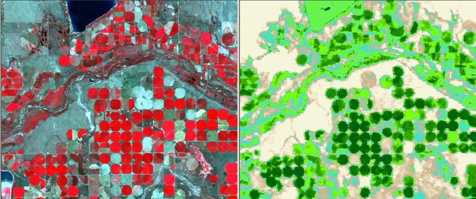
9 Product - Monthly ET Summed ET for the Mission Valley, MT for during July
10 Primary Inputs for METRIC Short wave and long wave (thermal) satellite images Digital Elevation Model (DEM) Weather Data from within or near the area of interest- windspeed, vapour pressure and reference ET Land Use Map 10
11 Concept of Surface Energy Balance 11
 ET (evapotranspiration) H (heat to air) G (heat to")
12 Surface Energy Balance ET flux is calculated as residual of the energy balance LE= R n - H - G Retrieved via satellite R n (Net Radiation) ET (evapotranspiration) H (heat to air) G (heat to ground) 12
13 Components of Energy Balance Net Radiation (R n ) Date and time Reflectance (brightness of surface) Surface temperature Heat to Air (H) Surface temperature Windspeed Vegetation type and roughness Surface to air temperature difference (dt) Heat to Ground (G) Amount of vegetation Net radiation Surface temperature Reflectance 13
14 Image Processing 14
15 Models in METRIC Radiance Reflectance Model 1 Surface Albedo Transmittance Model 2 Vegetation Indices NDVI, LAI,NDWI Model 3 Surface Temperature Surface Emissivity Model 4 Zom, Excess resistance Model 5 H (W/m 2 ) Model 6 ETrF24 ET24 (mm/day) Model 8 Rn (W/m 2 ) G (W/m 2 ) Model 7 15
16 Net Radiation (R n ) R n = (1-α) R s + R L R L - (1-ε 0 ) R L Surface Albedo Model 2 Incoming short wave R s Model 5 Outgoing long wave R L Model 5 Incoming long wave R L Model 5 At-satellite reflectances ρ tb Model 1 Surface Emissivities ε NB & ε 0 Model 4 T s Model 4 Spectral Radiance L λ Model 1 NDVI SAVI LAI Model 3 16

17 Sensible Heat Flux r ah = aerodynamic resistance u* = friction velocity (m/s) z 1, z 2 = height in meters above the zero plane displacement Two anchor pixels utilized where reliable values of H are estimated and solve for dt 17

18 Near Surface Temperature difference (dt) To compute sensible heat flux (H), define dt for each pixel dt = T near surface T air dt = T z1 -T z2 T air is unknown SEBAL and METRIC tm assume a linear relationship between T s and dt T s_dem is the delapsed surface temperature 18
19 Development of dt Vs Ts_dem Cold Pixel Hot Pixel H cold = R n G LE cold LE cold = 1.05 ETr H hot = R n G LE hot LE hot ~ 0 a well irrigated water surface with full cover where T s ~ T air (In SEBAL, H cold =0) dry bare soil 19

20 Training of METRIC tm Once Ts and dt are determined for the cold and hot pixels, the relationship between Ts and dt is defined as linear 20

21 Z om =0.12h Land use map Z om = LAI NDVI and albedo data 21
22 Soil Heat Flux (G) Empirical equation developed by Bastiaansen (1995) : An alternative equation was developed by Tasumi et al (2003) using soil heat flux data developed by Dr. J. L Wright (USDA) for irrigated crops near Kimberly, ID. LAI 0.5 LAI <
23 Current G functions G/R n current LAI 0.5 G/R n for moist surface LAI < 0.5 G = fn(h) after suggestion of Stull (1988) and development of Allen (2010, memo) G For water (NDVI<0): On average for deep clear water, G/R n = 0.5 For shallow turbid water, G/R n < 0.5 For snow: If α >.47, assume G/R n =
24 Solving for ET and computing LE for longer periods 24
25 Calculation of Instantaneous ET Applying the energy balance equation, calculate LE: LE = R n G H This ET rate expressed as latent heat (W/m2) is converted into depth of liquid evaporated as : where, 25
26 What about the rest of the day? Month? and year??? 26
27 ET r F For longer time periods, METRIC uses Reference ET fraction (ET r F) to extrapolate in time synonymous with Kc ET r is the reference ET calculated for the time of the image Assumptions: The fraction ET r F is nearly constant for the day ET r provides a good estimate of the climatic demands placed on each pixel. ET 24 (mm/day) = ET r F X ET r _ 24 ET r_24 is the cumulative 24-hour ET r for the day of the image 27
28 Allen et al.,
29 Comparison with local K c curves 29
30 24-Hour Evapotranspiration (ET24) 30

31 Seasonal ET map is desired which covers an entire growing season for quantifying water consumption Seasonal ET Derived from ETrF images by interpolating between processed images Generally, one image per month is sufficient Assumption: ET for the entire area of interest changes in proportion to changes in the ET r at the weather station 31


32 Adjustment for background evaporation to account for Inter image Rainfall ET from August13,1997 not adjusted for background soil evaporation ET from August13,1997 adjusted for background soil evaporation 32

33 Kimberly, Idaho (Snake River Basin) 33
34 Validation of ET estimates Confirmation of ET from remote sensing with independent measurement is highly desirable Estimate of H includes internal biases that account for biases in R n, G, T s etc. Therefore, comparisons are best made between measured and estimated ET, not H Ground data must be accurate biased H Less biased LE H = R n G LE LE = R n G - H biased R n, G 34
35 Accuracy of ET Satellite is 705 km above the earth ET is impacted by aerodynamics invisible to the satellite Design of SEBAL and METRIC make process relatively insensitive to the parameterization of aerodynamics Magic of the dt Vs T s provides internal and relatively automatic calibration METRIC combines the strengths of energy balance from satellite and accuracy of ground-based reference ET calculation 35


36 Applications ET maps are valuable for: Determining actual ET Ground Water Depletions Water Right Conflicts Refining crop coefficient curves Evaluation of regional and global climate models 36
37 Acknowlegements Adapted from workshop presentation by Dr. Richard Allen, University of Idaho. 37
38 Questions? 38
39 Additional Slides 39


40 Solar Radiation and Reflectance non-reflected radiation is what is absorbed at the surface and part of the energy balance. Therefore it is important to calculate it accurately 40
41 Friction Velocity Assume windspeed at 200m is constant 41
Estimation of Wavelet Based Spatially Enhanced Evapotranspiration Using Energy Balance Approach
 Estimation of Wavelet Based Spatially Enhanced Evapotranspiration Using Energy Balance Approach Dr.Gowri 1 Dr.Thirumalaivasan 2 1 Associate Professor, Jerusalem College of Engineering, Department of Civil
Evaluation of SEBAL Model for Evapotranspiration Mapping in Iraq Using Remote Sensing and GIS
 Evaluation of SEBAL Model for Evapotranspiration Mapping in Iraq Using Remote Sensing and GIS Hussein Sabah Jaber* Department of Civil Engineering, University Putra Malaysia, 43400 UPM Serdang, Selangor,
Google Earth Engine METRIC (GEM) Application for Remote Sensing of Evapotranspiration
 Application for Remote Sensing of Evapotranspiration") Google Earth Engine METRIC (GEM) Application for Remote Sensing of Evapotranspiration Nadya Alexander Sanchez, Quinn Hart, Justin Merz, and Nick Santos Center for Watershed Sciences University of California,
Google Earth Engine METRIC (GEM) Application for Remote Sensing of Evapotranspiration Nadya Alexander Sanchez, Quinn Hart, Justin Merz, and Nick Santos Center for Watershed Sciences University of California,
METRIC: High Resolution Satellite Quantification of Evapotranspiration
 Copyright, R.G.Allen, University of Idaho, 2005 METRIC: High Resolution Satellite Quantification of Evapotranspiration University of Idaho, Kimberly, Idaho Part Two Energy Balance Co-developers and Collaborators:
SEBAL. Idaho Implementation. Advanced Training and Users Manual. August, 2002 Version 1.0
 SEBAL Surface Energy Balance Algorithms for Land Idaho Implementation Advanced Training and Users Manual August, 2002 Version 1.0 Waters Consulting University of Idaho WaterWatch, Inc. Nelson, British
 Noori.samira@gmail.com sanaein@gmail.com s.m.hasheminia@gmail.com . inst R n G R n inst (wm - ) (wm - ) G (wm - ) wm - R n Surface Energy Balance Algorithm for Land (R s ) (R s ) (R l ) (R l ) a k R n
Simplified SEBAL method for estimating vast areal evapotranspiration with MODIS data
 Water Science and Engineering, 2011, 4(1): 24-35 doi:10.3882/j.issn.1674-2370.2011.01.003 http://www.waterjournal.cn e-mail: wse2008@vip.163.com Simplified SEBAL method for estimating vast areal evapotranspiration
Comparison of the Automatically Calibrated Google Evapotranspiration Application - EEFlux and the Manually Calibrated METRIC Application
 1 2 3 4 5 6 7 8 9 10 11 12 13 14 15 16 17 18 19 20 21 22 23 24 25 26 27 28 29 30 31 Article Comparison of the Automatically Calibrated Google Evapotranspiration Application - EEFlux and the Manually Calibrated
May 3, :41 AOGS - AS 9in x 6in b951-v16-ch13 LAND SURFACE ENERGY BUDGET OVER THE TIBETAN PLATEAU BASED ON SATELLITE REMOTE SENSING DATA
 Advances in Geosciences Vol. 16: Atmospheric Science (2008) Eds. Jai Ho Oh et al. c World Scientific Publishing Company LAND SURFACE ENERGY BUDGET OVER THE TIBETAN PLATEAU BASED ON SATELLITE REMOTE SENSING
John R. Mecikalski #1, Martha C. Anderson*, Ryan D. Torn #, John M. Norman*, George R. Diak #
 P4.22 THE ATMOSPHERE-LAND EXCHANGE INVERSE (ALEXI) MODEL: REGIONAL- SCALE FLUX VALIDATIONS, CLIMATOLOGIES AND AVAILABLE SOIL WATER DERIVED FROM REMOTE SENSING INPUTS John R. Mecikalski #1, Martha C. Anderson*,
Evaporative Fraction and Bulk Transfer Coefficients Estimate through Radiometric Surface Temperature Assimilation
 Evaporative Fraction and Bulk Transfer Coefficients Estimate through Radiometric Surface Temperature Assimilation Francesca Sini, Giorgio Boni CIMA Centro di ricerca Interuniversitario in Monitoraggio
Near Real-time Evapotranspiration Estimation Using Remote Sensing Data
 Near Real-time Evapotranspiration Estimation Using Remote Sensing Data by Qiuhong Tang 08 Aug 2007 Land surface hydrology group of UW Land Surface Hydrology Research Group ❶ ❷ ❸ ❹ Outline Introduction
Evapotranspiration. Andy Black. CCRN Processes Workshop, Hamilton, ON, Sept Importance of evapotranspiration (E)
") Evapotranspiration Andy Black CCRN Processes Workshop, Hamilton, ON, 12-13 Sept 213 Importance of evapotranspiration (E) This process is important in CCRN goals because 1. Major component of both terrestrial
Evapotranspiration Andy Black CCRN Processes Workshop, Hamilton, ON, 12-13 Sept 213 Importance of evapotranspiration (E) This process is important in CCRN goals because 1. Major component of both terrestrial
MODIS-based estimates of the regional evapotranspiration
 Remote Sensing for Environmental Monitoring and Change Detection (Proceedings of Symposium HS3007 at IUGG2007, Perugia, July 2007). IAHS Publ. 316, 2007. 181 MODIS-based estimates of the regional evapotranspiration
SUPPORTING INFORMATION. Ecological restoration and its effects on the
 SUPPORTING INFORMATION Ecological restoration and its effects on the regional climate: the case in the source region of the Yellow River, China Zhouyuan Li, Xuehua Liu,* Tianlin Niu, De Kejia, Qingping
Physical Aspects of Surface Energy Balance and Earth Observation Systems in Agricultural Practice
 Physical Aspects of Surface Energy Balance and Earth Observation Systems in Agricultural Practice Henk de Bruin During the visit to Pachacamac we contemplate about the 4 elements, fire, air, water and
Learning Objectives. Thermal Remote Sensing. Thermal = Emitted Infrared
 November 2014 lava flow on Kilauea (USGS Volcano Observatory) (http://hvo.wr.usgs.gov) Landsat-based thermal change of Nisyros Island (volcanic) Thermal Remote Sensing Distinguishing materials on the ground
Mapping surface fluxes using Visible - Near Infrared and Thermal Infrared data with the SEBAL Algorithm
 Mapping surface fluxes using Visible - Near Infrared and Thermal Infrared data with the SEBAL Algorithm F. Jacob 1, A. Olioso 1, X.F. Gu 1, J.F. Hanocq 1, O. Hautecoeur 2, and M. Leroy 2 1 INRA bioclimatologie,
Zachary Holden - US Forest Service Region 1, Missoula MT Alan Swanson University of Montana Dept. of Geography David Affleck University of Montana
 Progress modeling topographic variation in temperature and moisture for inland Northwest forest management Zachary Holden - US Forest Service Region 1, Missoula MT Alan Swanson University of Montana Dept.
Evapotranspiration monitoring with Meteosat Second Generation satellites: method, products and utility in drought detection.
 Evapotranspiration monitoring with Meteosat Second Generation satellites: method, products and utility in drought detection. Nicolas Ghilain Royal Meteorological Institute Belgium EUMeTrain Event week
Evapotranspiration. Rabi H. Mohtar ABE 325
 Evapotranspiration Rabi H. Mohtar ABE 325 Introduction What is it? Factors affecting it? Why we need to estimate it? Latent heat of vaporization: Liquid gas o Energy needed o Cooling process Saturation
Surface temperature what does this data tell us about micro-meteorological processes?
 Surface temperature what does this data tell us about micro-meteorological processes? Prof. Dr. Eberhard Parlow Meteorology, Climatology and Remote Sensing (MCR Lab) Department of Environmental Sciences
USGS Water Census Guidelines and Specifications for ET Remote Sensing
 USGS Water Census Guidelines and Specifications for ET Remote Sensing U.S. Department of the Interior U.S. Geological Survey Guidelines and specifications Many prior and ongoing crop ET remote sensing
Flux Tower Data Quality Analysis in the North American Monsoon Region
 Flux Tower Data Quality Analysis in the North American Monsoon Region 1. Motivation The area of focus in this study is mainly Arizona, due to data richness and availability. Monsoon rains in Arizona usually
Eric. W. Harmsen 1, John Mecikalski 2, Pedro Tosado Cruz 1 Ariel Mercado Vargas 1
 Estimating Evapotranspiration using Satellite Remote Sensing in Puerto Rico, Haiti and the Dominican Republic Eric. W. Harmsen 1, John Mecikalski 2, Pedro Tosado Cruz 1 Ariel Mercado Vargas 1 1. University
Temperature and Emissivity from AHS data in the framework of the AGRISAR and EAGLE campaigns
 AGRISAR and EAGLE Campaigns Final Workshop 15-16 October 2007 (ESA/ESTEC, Noordwijk, The Netherlands) Temperature and Emissivity from AHS data in the framework of the AGRISAR and EAGLE campaigns J. A.
Evaluation of a MODIS Triangle-based Algorithm for Improving ET Estimates in the Northern Sierra Nevada Mountain Range
 Evaluation of a MODIS Triangle-based Algorithm for Improving ET Estimates in the Northern Sierra Nevada Mountain Range Kyle R. Knipper 1, Alicia M. Kinoshita 2, and Terri S. Hogue 1 January 5 th, 2015
Remote sensing estimates of actual evapotranspiration in an irrigation district
 Engineers Australia 29th Hydrology and Water Resources Symposium 21 23 February 2005, Canberra Remote sensing estimates of actual evapotranspiration in an irrigation district Cressida L. Department of
Assimilation of satellite derived soil moisture for weather forecasting
 Assimilation of satellite derived soil moisture for weather forecasting www.cawcr.gov.au Imtiaz Dharssi and Peter Steinle February 2011 SMOS/SMAP workshop, Monash University Summary In preparation of the
Remote sensing estimation of land surface evapotranspiration of typical river basins in China
 220 Remote Sensing for Environmental Monitoring and Change Detection (Proceedings of Symposium HS3007 at IUGG2007, Perugia, July 2007). IAHS Publ. 316, 2007. Remote sensing estimation of land surface evapotranspiration
Soil Water Atmosphere Plant (SWAP) Model: I. INTRODUCTION AND THEORETICAL BACKGROUND
 Model: I. INTRODUCTION AND THEORETICAL BACKGROUND") Soil Water Atmosphere Plant (SWAP) Model: I. INTRODUCTION AND THEORETICAL BACKGROUND Reinder A.Feddes Jos van Dam Joop Kroes Angel Utset, Main processes Rain fall / irrigation Transpiration Soil evaporation
Soil Water Atmosphere Plant (SWAP) Model: I. INTRODUCTION AND THEORETICAL BACKGROUND Reinder A.Feddes Jos van Dam Joop Kroes Angel Utset, Main processes Rain fall / irrigation Transpiration Soil evaporation
WATER AND ENERGY BALANCE ESTIMATION IN PUERTO RICO USING SATELLITE REMOTE SENSING
 WATER AND ENERGY BALANCE ESTIMATION IN PUERTO RICO USING SATELLITE REMOTE SENSING Eric. W. Harmsen, Ariel Mercado Vargas, Pedro Tosado Cruz, Jonellys M Maldonado Morales and Angel O. Ortiz Lozada OCTAVA
Sensitivity Analysis of METRIC Based Evapotranspiration Algorithm
 Int. J. Environ. Res., 7():07-, Spring 0 ISSN: 75-85 Sensitivity Analysis of METRIC Based Evapotranspiration Algorithm Mokhtari, M. H. &a, Ahmad, B. *, Hoveidi, H., Busu, I. Department of Remote Sensing,
GMES: calibration of remote sensing datasets
 GMES: calibration of remote sensing datasets Jeremy Morley Dept. Geomatic Engineering jmorley@ge.ucl.ac.uk December 2006 Outline Role of calibration & validation in remote sensing Types of calibration
The role of soil moisture in influencing climate and terrestrial ecosystem processes
 1of 18 The role of soil moisture in influencing climate and terrestrial ecosystem processes Vivek Arora Canadian Centre for Climate Modelling and Analysis Meteorological Service of Canada Outline 2of 18
5. General Circulation Models
 5. General Circulation Models I. 3-D Climate Models (General Circulation Models) To include the full three-dimensional aspect of climate, including the calculation of the dynamical transports, requires
The Two Source Energy Balance model using satellite, airborne and proximal remote sensing
 The using satellite, airborne and proximal remote sensing 7 years in a relationship Héctor Nieto Hector.nieto@irta.cat Resistance Energy Balance Models (REBM) E R e n H G Physics based on an analogy to
GCOM-W1 now on the A-Train
 GCOM-W1 now on the A-Train GCOM-W1 Global Change Observation Mission-Water Taikan Oki, K. Imaoka, and M. Kachi JAXA/EORC (& IIS/The University of Tokyo) Mini-Workshop on A-Train Science, March 8 th, 2013
Multi-scale Remote Assessment of Land-surface Hydrologic Response to Stress
 Multi-scale Remote Assessment of Land-surface Hydrologic Response to Stress M.C. Anderson J.M. Norman U Wisconsin-Madison W.P. Kustas USDA-ARS, HRSL T.P. Meyers NOAA-ATDD J.M. Jacobs U New Hampshire NASA
ATMOS 5140 Lecture 1 Chapter 1
 ATMOS 5140 Lecture 1 Chapter 1 Atmospheric Radiation Relevance for Weather and Climate Solar Radiation Thermal Infrared Radiation Global Heat Engine Components of the Earth s Energy Budget Relevance for
Remote Sensing Applications for Land/Atmosphere: Earth Radiation Balance
 Remote Sensing Applications for Land/Atmosphere: Earth Radiation Balance - Introduction - Deriving surface energy balance fluxes from net radiation measurements - Estimation of surface net radiation from
Proceedings. Ricardo Neves de Souza Lima 1, * and Celso Bandeira de Melo Ribeiro 2
 Proceedings Spatial Variability of Daily Evapotranspiration in a Mountainous Watershed by Coupling Surface Energy Balance and Solar Radiation Model with Gridded Weather Dataset Ricardo Neves de Souza Lima
A methodology for estimation of surface evapotranspiration
 1 A methodology for estimation of surface evapotranspiration over large areas using remote sensing observations Le Jiang and Shafiqul Islam Cincinnati Earth Systems Science Program, Department of Civil
1. GLACIER METEOROLOGY - ENERGY BALANCE
 Summer School in Glaciology McCarthy, Alaska, 5-15 June 2018 Regine Hock Geophysical Institute, University of Alaska, Fairbanks 1. GLACIER METEOROLOGY - ENERGY BALANCE Ice and snow melt at 0 C, but this
Improved Fields of Satellite-Derived Ocean Surface Turbulent Fluxes of Energy and Moisture
 Improved Fields of Satellite-Derived Ocean Surface Turbulent Fluxes of Energy and Moisture First year report on NASA grant NNX09AJ49G PI: Mark A. Bourassa Co-Is: Carol Anne Clayson, Shawn Smith, and Gary
Remote Sensing of Environment
 Remote Sensing of Environment 131 (2013) 51 62 Contents lists available at SciVerse ScienceDirect Remote Sensing of Environment journal homepage: www.elsevier.com/locate/rse Effects of spatial aggregation
Evapotranspiration and Irrigation Water Requirements for Washington State
 Evapotranspiration and Irrigation Water Requirements for Washington State R. Troy Peters, PE, PhD Extension Irrigation Specialist Washington State University Irrigated Ag. Research and Extension Cntr Prosser,
Evaporation and Evapotranspiration
 Evaporation and Evapotranspiration Wossenu Abtew Assefa Melesse Evaporation and Evapotranspiration Measurements and Estimations 123 Dr. Wossenu Abtew South Florida Water Management District West Palm
Monitoring daily evapotranspiration in the Alps exploiting Sentinel-2 and meteorological data
 Monitoring daily evapotranspiration in the Alps exploiting Sentinel-2 and meteorological data M. Castelli, S. Asam, A. Jacob, M. Zebisch, and C. Notarnicola Institute for Earth Observation, Eurac Research,
Snow processes and their drivers in Sierra Nevada (Spain), and implications for modelling.
, and implications for modelling.") Snow processes and their drivers in Sierra Nevada (Spain), and implications for modelling. M.J. Polo, M.J. Pérez-Palazón, R. Pimentel, J. Herrero Granada,02 de November 2016 SECTIONS 1. 2. 3. 4. 5. Introduction
Snow processes and their drivers in Sierra Nevada (Spain), and implications for modelling. M.J. Polo, M.J. Pérez-Palazón, R. Pimentel, J. Herrero Granada,02 de November 2016 SECTIONS 1. 2. 3. 4. 5. Introduction
Land Data Assimilation at NCEP NLDAS Project Overview, ECMWF HEPEX 2004
 Dag.Lohmann@noaa.gov, Land Data Assimilation at NCEP NLDAS Project Overview, ECMWF HEPEX 2004 Land Data Assimilation at NCEP: Strategic Lessons Learned from the North American Land Data Assimilation System
Mapping Evapotranspiration and Drought at Local to Continental Scales Using Thermal Remote Sensing
 Mapping Evapotranspiration and Drought at Local to Continental Scales Using Thermal Remote Sensing M.C. Anderson, W.P. Kustas USDA-ARS, Hydrology and Remote Sensing Laboratory J.M Norman University of
Introduction to Satellite Derived Vegetation Indices
 Introduction to the Use of Geospatial Information Technology for Drought Risk Management 13-17 November, 2017 Tonle Bassac II Restaurant, Phnom Penh, Cambodia Introduction to Satellite Derived Vegetation
EVAPORATION GEOG 405. Tom Giambelluca
 EVAPORATION GEOG 405 Tom Giambelluca 1 Evaporation The change of phase of water from liquid to gas; the net vertical transport of water vapor from the surface to the atmosphere. 2 Definitions Evaporation:
VIC Hydrology Model Training Workshop Part II: Building a model
 VIC Hydrology Model Training Workshop Part II: Building a model 11-12 Oct 2011 Centro de Cambio Global Pontificia Universidad Católica de Chile Ed Maurer Civil Engineering Department Santa Clara University
Vegetation Remote Sensing
 Vegetation Remote Sensing Huade Guan Prepared for Remote Sensing class Earth & Environmental Science University of Texas at San Antonio November 2, 2005 Outline Why do we study vegetation remote sensing?
METEOSAT SECOND GENERATION DATA FOR ASSESSMENT OF SURFACE MOISTURE STATUS
 METEOSAT SECOND GENERATION DATA FOR ASSESSMENT OF SURFACE MOISTURE STATUS Simon Stisen (1), Inge Sandholt (1), Rasmus Fensholt (1) (1) Institute of Geography, University of Copenhagen, Oestervoldgade 10,
Joint International Surface Working Group and Satellite Applications Facility on Land Surface Analysis Workshop, IPMA, Lisboa, June 2018
 Joint International Surface Working Group and Satellite Applications Facility on Land Surface Analysis Workshop, IPMA, Lisboa, 26-28 June 2018 Introduction Soil moisture Evapotranspiration Future plan
EVALUATION AND MONITORING OF SNOWCOVER WATER RESOURCES IN CARPATHIAN BASINS USING GEOGRAPHIC INFORMATION AND SATELLITE DATA
 EVALUATION AND MONITORING OF SNOWCOVER WATER RESOURCES IN CARPATHIAN BASINS USING GEOGRAPHIC INFORMATION AND SATELLITE DATA Gheorghe Stancalie, Simona Catana, Anisoara Iordache National Institute of Meteorology
ESTIMATION OF ATMOSPHERIC COLUMN AND NEAR SURFACE WATER VAPOR CONTENT USING THE RADIANCE VALUES OF MODIS
 ESTIMATION OF ATMOSPHERIC COLUMN AND NEAR SURFACE WATER VAPOR CONTENT USIN THE RADIANCE VALUES OF MODIS M. Moradizadeh a,, M. Momeni b, M.R. Saradjian a a Remote Sensing Division, Centre of Excellence
Operational Evapotranspiration Mapping Using Remote Sensing and Weather Datasets: A New Parameterization for the SSEB Approach
 University of Nebraska - Lincoln DigitalCommons@University of Nebraska - Lincoln USGS Staff -- Published Research US Geological Survey 2013 Operational Evapotranspiration Mapping Using Remote Sensing and
Inter-linkage case study in Pakistan
 7 th GEOSS Asia Pacific Symposium GEOSS AWCI Parallel Session: 26-28 May, 2014, Tokyo, Japan Inter-linkage case study in Pakistan Snow and glaciermelt runoff modeling in Upper Indus Basin of Pakistan Maheswor
Application of Remotely Sensed Data in the Estimation of Net Radiation at the Earth s Surface in Clear Sky Conditions
 American Journal of Remote Sensing 2018; 6(1): 23-28 http://www.sciencepublishinggroup.com/j/ajrs doi: 10.11648/j.ajrs.20180601.14 ISSN: 2328-5788 (Print); ISSN: 2328-580X (Online) Application of Remotely
Solar Radiation and Environmental Biophysics Geo 827, MSU Jiquan Chen Oct. 6, 2015
 Solar Radiation and Environmental Biophysics Geo 827, MSU Jiquan Chen Oct. 6, 2015 1) Solar radiation basics 2) Energy balance 3) Other relevant biophysics 4) A few selected applications of RS in ecosystem
5B.1 DEVELOPING A REFERENCE CROP EVAPOTRANSPIRATION CLIMATOLOGY FOR THE SOUTHEASTERN UNITED STATES USING THE FAO PENMAN-MONTEITH ESTIMATION TECHNIQUE
 DEVELOPING A REFERENCE CROP EVAPOTRANSPIRATION CLIMATOLOGY FOR THE SOUTHEASTERN UNITED STATES USING THE FAO PENMAN-MONTEITH ESTIMATION TECHNIQUE Heather A. Dinon*, Ryan P. Boyles, and Gail G. Wilkerson
Mcebisi M. Mkhwanazi 1, José L. Chávez Civil and Environmental Engineering Department, Colorado State University
 Hydrology Days 2013 Mapping evapotranspiration with the remote sensing ET algorithms METRIC and SEBAL under advective and non-advective conditions: accuracy determination with weighing lysimeters Mcebisi
Climate Roles of Land Surface
 Lecture 5: Land Surface and Cryosphere (Outline) Climate Roles Surface Energy Balance Surface Water Balance Sea Ice Land Ice (from Our Changing Planet) Surface Albedo Climate Roles of Land Surface greenhouse
Snow II: Snowmelt and energy balance
 Snow II: Snowmelt and energy balance The are three basic snowmelt phases 1) Warming phase: Absorbed energy raises the average snowpack temperature to a point at which the snowpack is isothermal (no vertical
ONE DIMENSIONAL CLIMATE MODEL
 JORGE A. RAMÍREZ Associate Professor Water Resources, Hydrologic and Environmental Sciences Civil Wngineering Department Fort Collins, CO 80523-1372 Phone: (970 491-7621 FAX: (970 491-7727 e-mail: Jorge.Ramirez@ColoState.edu
Glaciology HEAT BUDGET AND RADIATION
 HEAT BUDGET AND RADIATION A Heat Budget 1 Black body radiation Definition. A perfect black body is defined as a body that absorbs all radiation that falls on it. The intensity of radiation emitted by a
Seasonal and interannual relations between precipitation, soil moisture and vegetation in the North American monsoon region
 Seasonal and interannual relations between precipitation, soil moisture and vegetation in the North American monsoon region Luis A. Mendez-Barroso 1, Enrique R. Vivoni 1, Christopher J. Watts 2 and Julio
Radiation, Sensible Heat Flux and Evapotranspiration
 Radiation, Sensible Heat Flux and Evapotranspiration Climatological and hydrological field work Figure 1: Estimate of the Earth s annual and global mean energy balance. Over the long term, the incoming
OPERATIONAL EVAPOTRANSPIRATION MAPPING USING REMOTE SENSING AND WEATHER DATASETS: A NEW PARAMETERIZATION FOR THE SSEB APPROACH 1
 Vol. 49, No. 3 AMERICAN WATER RESOURCES ASSOCIATION e 2013 OPERATIONAL EVAPOTRANSPIRATION MAPPING USING REMOTE SENSING AND WEATHER DATASETS: A NEW PARAMETERIZATION FOR THE SSEB APPROACH 1 Gabriel B. Senay,
Soil moisture retrieval with remote sensing images for debris flow forecast in humid regions
 Monitoring, Simulation, Prevention and Remediation of Dense and Debris Flows III 89 Soil moisture retrieval with remote sensing images for debris flow forecast in humid regions Y. Zhao 1,2,3, H. Yang 1,2
Lecture 3a: Surface Energy Balance
 Lecture 3a: Surface Energy Balance Instructor: Prof. Johnny Luo http://www.sci.ccny.cuny.edu/~luo Total: 50 pts Absorption of IR radiation O 3 band ~ 9.6 µm Vibration-rotation interaction of CO 2 ~
OSI SAF SST Products and Services
 OSI SAF SST Products and Services Pierre Le Borgne Météo-France/DP/CMS (With G. Legendre, A. Marsouin, S. Péré, S. Philippe, H. Roquet) 2 Outline Satellite IR radiometric measurements From Brightness Temperatures
ATMOSPHERIC CIRCULATION AND WIND
 ATMOSPHERIC CIRCULATION AND WIND The source of water for precipitation is the moisture laden air masses that circulate through the atmosphere. Atmospheric circulation is affected by the location on the
Promoting Rainwater Harvesting in Caribbean Small Island Developing States Water Availability Mapping for Grenada Preliminary findings
 Promoting Rainwater Harvesting in Caribbean Small Island Developing States Water Availability Mapping for Grenada Preliminary findings National Workshop Pilot Project funded by The United Nations Environment
Evapotranspiration. Here, liquid water on surfaces or in the very thin surface layer of the soil that evaporates directly to the atmosphere
 Evapotranspiration Evaporation (E): In general, the change of state from liquid to gas Here, liquid water on surfaces or in the very thin surface layer of the soil that evaporates directly to the atmosphere
Land Surface Processes and Their Impact in Weather Forecasting
 Land Surface Processes and Their Impact in Weather Forecasting Andrea Hahmann NCAR/RAL with thanks to P. Dirmeyer (COLA) and R. Koster (NASA/GSFC) Forecasters Conference Summer 2005 Andrea Hahmann ATEC
Lecture 3a: Surface Energy Balance
 Lecture 3a: Surface Energy Balance Instructor: Prof. Johnny Luo http://www.sci.ccny.cuny.edu/~luo Surface Energy Balance 1. Factors affecting surface energy balance 2. Surface heat storage 3. Surface
Hydrologic Modelling of the Upper Malaprabha Catchment using ArcView SWAT
 Hydrologic Modelling of the Upper Malaprabha Catchment using ArcView SWAT Technical briefs are short summaries of the models used in the project aimed at nontechnical readers. The aim of the PES India
Data Fusion and Multi-Resolution Data
 Data Fusion and Multi-Resolution Data Nature.com www.museevirtuel-virtualmuseum.ca www.srs.fs.usda.gov Meredith Gartner 3/7/14 Data fusion and multi-resolution data Dark and Bram MAUP and raster data Hilker
GIS.
 GIS 389 Vol., No.3, Autumn 00 89-0 GIS Iranian Remote Sensing & GIS ( : ) ETM+ *.. 390/3/7 : 389/5/3 : (LST).. 00 3 ETM+.. MNF NDVI. SEBAL. FVC NDVI... (FVC) SEBAL (LULC) (LST) :. 887708 : : * Email: taleai@kntu.ac.ir
Eric. W. Harmsen 1, John Mecikalski 2, Vanessa Acaron 3 and Jayson Maldonado 3
 Estimating Ground-Level Solar Radiation and Evapotranspiration In Puerto Rico Using Satellite Remote Sensing Eric. W. Harmsen 1, John Mecikalski 2, Vanessa Acaron 3 and Jayson Maldonado 3 1 Department
LAND SURFACE ALBEDO AND DOWNWELLING SHORTWAVE RADIATION FROM MSG GEOSTATIONARY SATELLITE (METHOD FOR RETRIEVAL, VALIDATION, AND APPLICATION)
") LAND SURFACE ALBEDO AND DOWNWELLING SHORTWAVE RADIATION FROM MSG GEOSTATIONARY SATELLITE (METHOD FOR RETRIEVAL, VALIDATION, AND APPLICATION) Dominique Carrer, Jean-Louis Roujean, Olivier Hautecoeur, Jean-Christophe
LAND SURFACE ALBEDO AND DOWNWELLING SHORTWAVE RADIATION FROM MSG GEOSTATIONARY SATELLITE (METHOD FOR RETRIEVAL, VALIDATION, AND APPLICATION) Dominique Carrer, Jean-Louis Roujean, Olivier Hautecoeur, Jean-Christophe
A new perspective on aerosol direct radiative effects in South Atlantic and Southern Africa
 A new perspective on aerosol direct radiative effects in South Atlantic and Southern Africa Ian Chang and Sundar A. Christopher Department of Atmospheric Science University of Alabama in Huntsville, U.S.A.
Electromagnetic Radiation. Radiation and the Planetary Energy Balance. Electromagnetic Spectrum of the Sun
 Radiation and the Planetary Energy Balance Electromagnetic Radiation Solar radiation warms the planet Conversion of solar energy at the surface Absorption and emission by the atmosphere The greenhouse
Remote sensing derived evapotranspiration: comparisons to observations and models and results over the full MSG disk and selected basins
 4 th LSA-SAF WORKSHOP Toulouse,France, 15 th to 17 th November 2010 Remote sensing derived evapotranspiration: comparisons to observations and models and results over the full MSG disk and selected basins
The Community Noah LSM with Multi-physics Options
 The Community Noah LSM with Multi-physics Options Guo-Yue Niu Collaborators: ZL Yang, KE Mitchell, F Chen, MB Ek, M. Barlage, L. Longuevergne, A Kumar, K Manning, D Niyogi, E Rosero, M Tewari, and Y. Xia
Estimation of evapotranspiration using satellite TOA radiances Jian Peng
 Estimation of evapotranspiration using satellite TOA radiances Jian Peng Max Planck Institute for Meteorology Hamburg, Germany Satellite top of atmosphere radiances Slide: 2 / 31 Surface temperature/vegetation
METR 130: Lecture 2 - Surface Energy Balance - Surface Moisture Balance. Spring Semester 2011 February 8, 10 & 14, 2011
 METR 130: Lecture 2 - Surface Energy Balance - Surface Moisture Balance Spring Semester 2011 February 8, 10 & 14, 2011 Reading Arya, Chapters 2 through 4 Surface Energy Fluxes (Ch2) Radiative Fluxes (Ch3)
Drought Monitoring with Hydrological Modelling
 st Joint EARS/JRC International Drought Workshop, Ljubljana,.-5. September 009 Drought Monitoring with Hydrological Modelling Stefan Niemeyer IES - Institute for Environment and Sustainability Ispra -
Remote sensing Based Assessment of Urban Heat Island Phenomenon in Nagpur Metropolitan Area
 International Journal of Information & Computation Technology. ISSN 0974-2239 Volume 4, Number 11 (2014), pp. 1069-1074 International Research Publications House http://www. irphouse.com Remote sensing
DEVELOPMENT OF A LARGE-SCALE HYDROLOGIC PREDICTION SYSTEM
 JP3.18 DEVELOPMENT OF A LARGE-SCALE HYDROLOGIC PREDICTION SYSTEM Ji Chen and John Roads University of California, San Diego, California ABSTRACT The Scripps ECPC (Experimental Climate Prediction Center)
Modeling of Environmental Systems
 Modeling of Environmental Systems While the modeling of predator-prey dynamics is certainly simulating an environmental system, there is more to the environment than just organisms Recall our definition
Remote Sensing of Snow and Ice. Lecture 21 Nov. 9, 2005
 Remote Sensing of Snow and Ice Lecture 21 Nov. 9, 2005 Topics Remote sensing snow depth: passive microwave (covered in Lecture 14) Remote sensing sea ice and ice sheet elevation change: Lidar - ICESat
Benefits of NT over CT. Water conservation in the NT benefits from reduced ET and runoff, and increased infiltration.
 Benefits of NT over CT Water conservation in the NT benefits from reduced ET and runoff, and increased infiltration. Weed control. Increased water and root penetration Uniform stands. Typically 4 to 8
Investigation of Relationship Between Rainfall and Vegetation Index by Using NOAA/AVHRR Satellite Images
 World Applied Sciences Journal 14 (11): 1678-1682, 2011 ISSN 1818-4952 IDOSI Publications, 2011 Investigation of Relationship Between Rainfall and Vegetation Index by Using NOAA/AVHRR Satellite Images
Parameterization of land surface evaporation by means of location dependent potential evaporation and surface temperature range
 Exchange Processes at the Land Surface for a Range of Space and Time Scales (Proceedings of the Yokohama Symposium, July 1993). IAHS Publ. no. 212, 1993. 561 Parameterization of land surface evaporation