Uncertainty in the SWAT Model Simulations due to Different Spatial Resolution of Gridded Precipitation Data
|
|
|
- Buck Cooper
- 5 years ago
- Views:
Transcription
1 Uncertainty in the SWAT Model Simulations due to Different Spatial Resolution of Gridded Precipitation Data Vamsi Krishna Vema 1, Jobin Thomas 2, Jayaprathiga Mahalingam 1, P. Athira 4, Cicily Kurian 1, K.P. Sudheer 3 1 Research Scholar (IIT Madras) 2 Senior Project Officer (IIT Madras) 3 Professor (IIT Madras) 4 Assistant Professor (IIT Palakkad) Department of Civil Engineering, Indian Institute of Technology Madras 19 January 2018


2 Introduction Watershed scale hydrological models important tools for impact evaluation Applications include: Watershed management, irrigation planning, flood forecasting, etc. Constraint - Uncertainty Input Data Uncertainty Structure Representation Parameter 2
3 Significance of Precipitation Data Gauge Data Gridded Data Meteorological Station Computed: Satellite Data Derived: Gauge and Satellite Data Point measurement Spatial measurement Poor spatial coverage Good spatial coverage Long records (maximum 350 years) Short records (maximum 25 years) Observer errors, instrumental errors, errors due to environmental influences Instrument calibration, changing algorithms 3

4 Process Representation in SWAT SWAT uses data from one precipitation gauging station that is nearest to the centroid of each sub-basin Poor representation of the spatial variability 4
5 Objective To assess the variability in the model output with respect to precipitation data of different spatial resolutions and watershed size 5

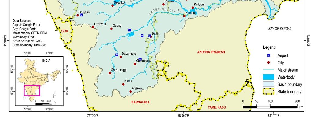
6 Study Area 6
7 Model Setup Data Resolution Source Digital Elevation Map 90 m Shuttle Radar Topography Mission (SRTM) Land use Map 500 m WATERBASE Soil Map 1000 m Harmonized World Soil Database (HWSD) Weather Data 1 o x 1 o 0.5 o x 0.5 o India Meteorological Department 0.25 o x 0.25 o (IMD) 7
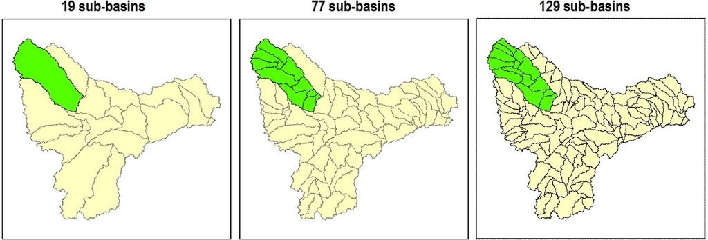
8 Scenarios Watershed Discretization 19 sub-watersheds (CI Threshold = 7000 km 2 ) 77 sub-watersheds (2000 km 2 ) 129 sub-watersheds (1000 km 2 ) Precipitation Input Data Set Spatial Resolution (Lat x Long) Data Period IMD 1 o x 1 o IMD 0.5 o x 0.5 o IMD 0.25 o x 0.25 o
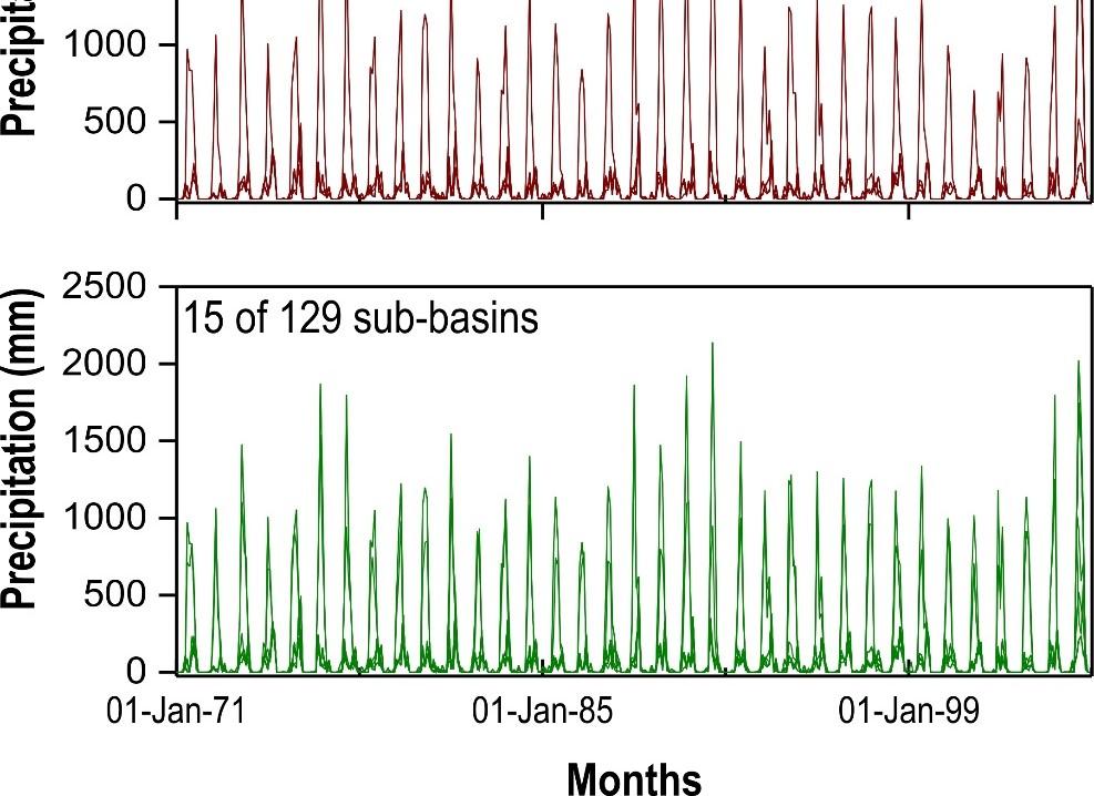
9 Precipitation 19 Sub-basins 1 o 0.5 o 0.25 o 9

10 Precipitation 77 Sub-basins 1 o 0.5 o 0.25 o 10
11 Precipitation 129 Sub-basins 1 o 0.5 o 0.25 o 11
12 Evapotranspiration 19 Sub-basins 1 o 0.5 o 0.25 o 12
13 Evapotranspiration 77 Sub-basins 1 o 0.5 o 0.25 o 13
14 Evapotranspiration 129 Sub-basins 1 o 0.5 o 0.25 o 14
15 Surface Runoff 19 Sub-basins 1 o 0.5 o 0.25 o 15

16 Surface Runoff 77 Sub-basins 1 o 0.5 o 0.25 o 16
17 Surface Runoff 129 Sub-basins 1 o 0.5 o 0.25 o 17
18 Sediment Yield 19 Sub-basins 1 o 0.5 o 0.25 o 18
19 Sediment Yield 77 Sub-basins 1 o 0.5 o 0.25 o 19
20 Sediment Yield 129 Sub-basins 1 o 0.5 o 0.25 o 20
21 Monthly Hydrograph HMG-IITM 21
22 PBIAS (with respect to flow from 1 o ) HMG-IITM No. of Subbasins/Degree 0.5 o 0.25 o
23 Variability in Precipitation 23
24 Conclusions HMG-IITM Uncertainty in input data needs to be considered for efficient water resources planning and management The uncertainty in representation of spatial variability of rainfall data is significant The forcing data selection needs to be done carefully 24
Improved ensemble representation of soil moisture in SWAT for data assimilation applications
 Improved ensemble representation of soil moisture in SWAT for data assimilation applications Amol Patil and RAAJ Ramsankaran Hydro-Remote Sensing Applications (H-RSA) Group, Department of Civil Engineering
Impact of different types of meteorological data inputs on predicted hydrological and erosive responses to projected land use change
 Impact of different types of meteorological data inputs on predicted hydrological and erosive responses to projected land use change Suman Bhattacharyya 1 & Joy Sanyal * 1 2 1 Department of Geography,
Hydrologic Modelling of the Upper Malaprabha Catchment using ArcView SWAT
 Hydrologic Modelling of the Upper Malaprabha Catchment using ArcView SWAT Technical briefs are short summaries of the models used in the project aimed at nontechnical readers. The aim of the PES India
MULTI MODEL ENSEMBLE FOR ASSESSING THE IMPACT OF CLIMATE CHANGE ON THE HYDROLOGY OF A SOUTH INDIAN RIVER BASIN
 MULTI MODEL ENSEMBLE FOR ASSESSING THE IMPACT OF CLIMATE CHANGE ON THE HYDROLOGY OF A SOUTH INDIAN RIVER BASIN P.S. Smitha, B. Narasimhan, K.P. Sudheer Indian Institute of Technology, Madras 2017 International
Overview of Data for CREST Model
 Overview of Data for CREST Model Xianwu Xue April 2 nd 2012 CREST V2.0 CREST V2.0 Real-Time Mode Forcasting Mode Data Assimilation Precipitation PET DEM, FDR, FAC, Slope Observed Discharge a-priori parameter
Liliana Pagliero June, 15 th 2011
 Liliana Pagliero liliana.pagliero@jrc.ec.europa.eu June, 15 th 2011 2/18 SWAT MODELLING AT PAN EUROPEAN SCALE: THE DANUBE BASIN PILOT STUDY Introduction The Danube Model Available databases Model set up
Simulation of sedimentation rates using the SWAT model A case study of the Tarbela Dam, Upper Indus Basin
 Simulation of sedimentation rates using the SWAT model A case study of the Tarbela Dam, Upper Indus Basin Ahammad, H. I 1., Crosato A 2,3., Maskey, S 2., Masih, I 2,*, McClain, M 2. 1 Punjab Irrigation
MODELING RUNOFF RESPONSE TO CHANGING LAND COVER IN PENGANGA SUBWATERSHED, MAHARASHTRA
 MODELING RUNOFF RESPONSE TO CHANGING LAND COVER IN PENGANGA SUBWATERSHED, MAHARASHTRA Abira Dutta Roy*, S.Sreekesh** *Research Scholar, **Associate Professor Centre for the Study of Regional Development,
Hydrological modelling of the Lena River using SWIM
 Hydrological modelling of the Lena River using SWIM Michel Wortmann 1 1 Potsdam Institute for Climate Impact Research (PIK), Germany July 8, 214 Contents 1 The Lena catchment and data used 1 1.1 Discharge
July, International SWAT Conference & Workshops
 July, 212 212 International SWAT Conference & Workshops Hydrological Modelling of Kosi and Gandak Basins using SWAT Model S. Dutta, Pritam Biswas, Sangita Devi, Suresh A Karth and Bimlesh kumar, Ganga
Basins-Level Heavy Rainfall and Flood Analyses
 Basins-Level Heavy Rainfall and Flood Analyses Peng Gao, Greg Carbone, and Junyu Lu Department of Geography, University of South Carolina (gaop@mailbox.sc.edu, carbone@mailbox.sc.edu, jlu@email.sc.edu)
Uncertainty analysis of nonpoint source pollution modeling:
 2013 SWAT Conference Uncertainty analysis of nonpoint source pollution modeling: An important implication for Soil and Water Assessment Tool Professor Zhenyao Shen 2013-07-17 Toulouse Contents 1 2 3 4
EFFICIENCY OF THE INTEGRATED RESERVOIR OPERATION FOR FLOOD CONTROL IN THE UPPER TONE RIVER OF JAPAN CONSIDERING SPATIAL DISTRIBUTION OF RAINFALL
 EFFICIENCY OF THE INTEGRATED RESERVOIR OPERATION FOR FLOOD CONTROL IN THE UPPER TONE RIVER OF JAPAN CONSIDERING SPATIAL DISTRIBUTION OF RAINFALL Dawen YANG, Eik Chay LOW and Toshio KOIKE Department of
Remote Sensing and GIS Applications for Hilly Watersheds SUBASHISA DUTTA DEPARTMENT OF CIVIL ENGINEERING IIT GUWAHATI
 Remote Sensing and GIS Applications for Hilly Watersheds SUBASHISA DUTTA DEPARTMENT OF CIVIL ENGINEERING IIT GUWAHATI Deciding Alternative Land Use Options in a Watershed Using GIS Source: Anita Prakash
URBAN WATERSHED RUNOFF MODELING USING GEOSPATIAL TECHNIQUES
 URBAN WATERSHED RUNOFF MODELING USING GEOSPATIAL TECHNIQUES DST Sponsored Research Project (NRDMS Division) By Prof. M. GOPAL NAIK Professor & Chairman, Board of Studies Email: mgnaikc@gmail.com Department
IMPACT OF CLIMATE CHANGE OVER THE ARABIAN PENINSULA
 IMPACT OF CLIMATE CHANGE OVER THE ARABIAN PENINSULA By: Talal Alharbi June, 29 2017 1 Motivation: In arid and semi-arid regions of the world the demand for fresh water resources is increasing due to: increasing
Gökhan Cüceloğlu, İzzet Öztürk. Istanbul Technical University Department of Environmental Engineering Maslak/IstanbulTurkey
 Assessing the Influence of Climate Datasets for Quantification of Water Balance Components in Black Sea Catchment: Case Study for Melen Watershed, Turkey Gökhan Cüceloğlu, İzzet Öztürk Istanbul Technical
Sanjeev Kumar Jha Assistant Professor Earth and Environmental Sciences Indian Institute of Science Education and Research Bhopal
 Sanjeev Kumar Jha Assistant Professor Earth and Environmental Sciences Indian Institute of Science Education and Research Bhopal Email: sanjeevj@iiserb.ac.in 1 Outline 1. Motivation FloodNet Project in
VIC Hydrology Model Training Workshop Part II: Building a model
 VIC Hydrology Model Training Workshop Part II: Building a model 11-12 Oct 2011 Centro de Cambio Global Pontificia Universidad Católica de Chile Ed Maurer Civil Engineering Department Santa Clara University
The Importance of Snowmelt Runoff Modeling for Sustainable Development and Disaster Prevention
 The Importance of Snowmelt Runoff Modeling for Sustainable Development and Disaster Prevention Muzafar Malikov Space Research Centre Academy of Sciences Republic of Uzbekistan Water H 2 O Gas - Water Vapor
Using MODIS imagery to validate the spatial representation of snow cover extent obtained from SWAT in a data-scarce Chilean Andean watershed
 Using MODIS imagery to validate the spatial representation of snow cover extent obtained from SWAT in a data-scarce Chilean Andean watershed Alejandra Stehr 1, Oscar Link 2, Mauricio Aguayo 1 1 Centro
Dr. S.SURIYA. Assistant professor. Department of Civil Engineering. B. S. Abdur Rahman University. Chennai
 Hydrograph simulation for a rural watershed using SCS curve number and Geographic Information System Dr. S.SURIYA Assistant professor Department of Civil Engineering B. S. Abdur Rahman University Chennai
Rainfall-runoff modelling using merged rainfall from radar and raingauge measurements
 Rainfall-runoff modelling using merged rainfall from radar and raingauge measurements Nergui Nanding, Miguel Angel Rico-Ramirez and Dawei Han Department of Civil Engineering, University of Bristol Queens
Near Real-Time Runoff Estimation Using Spatially Distributed Radar Rainfall Data. Jennifer Hadley 22 April 2003
 Near Real-Time Runoff Estimation Using Spatially Distributed Radar Rainfall Data Jennifer Hadley 22 April 2003 Introduction Water availability has become a major issue in Texas in the last several years,
Solution: The ratio of normal rainfall at station A to normal rainfall at station i or NR A /NR i has been calculated and is given in table below.
 3.6 ESTIMATION OF MISSING DATA Data for the period of missing rainfall data could be filled using estimation technique. The length of period up to which the data could be filled is dependent on individual
Evaluation of Flash flood Events Using NWP Model and Remotely Sensed Rainfall Estimates
 Evaluation of Flash flood Events Using NWP Model and Remotely Sensed Rainfall Estimates Dr. Ismail Yucel METU Civil Engineering Department and Fatih Keskin State Hydraulic Works HydroPredict 2010 Prague
MODULE 8 LECTURE NOTES 2 REMOTE SENSING APPLICATIONS IN RAINFALL-RUNOFF MODELLING
 MODULE 8 LECTURE NOTES 2 REMOTE SENSING APPLICATIONS IN RAINFALL-RUNOFF MODELLING 1. Introduction The most common application of the remote sensing techniques in the rainfall-runoff studies is the estimation
Assessment of solid load and siltation potential of dams reservoirs in the High Atlas of Marrakech (Moorcco) using SWAT Model
 using SWAT Model") Assessment of solid load and siltation potential of dams reservoirs in the High Atlas of Marrakech (Moorcco) using SWAT Model Amal Markhi: Phd Student Supervisor: Pr :N.Laftrouhi Contextualization Facing
Assessment of solid load and siltation potential of dams reservoirs in the High Atlas of Marrakech (Moorcco) using SWAT Model Amal Markhi: Phd Student Supervisor: Pr :N.Laftrouhi Contextualization Facing
ENGRG Introduction to GIS
 ENGRG 59910 Introduction to GIS Michael Piasecki March 17, 2014 Lecture 08: Terrain Analysis Outline: Terrain Analysis Earth Surface Representation Contour TIN Mass Points Digital Elevation Models Slope
Climate Change Impact Assessment on Indian Water Resources. Ashvin Gosain, Sandhya Rao, Debajit Basu Ray
 Climate Change Impact Assessment on Indian Water Resources Ashvin Gosain, Sandhya Rao, Debajit Basu Ray Objectives of the Study To quantify the impact of the climate change on the water resources of the
Flash Flood Guidance System On-going Enhancements
 Flash Flood Guidance System On-going Enhancements Hydrologic Research Center, USA Technical Developer SAOFFG Steering Committee Meeting 1 10-12 July 2017 Jakarta, INDONESIA Theresa M. Modrick Hansen, PhD
Assessing climate change impacts on the water resources in Pune, India, using downscaling and hydrologic modeling
 Assessing climate change impacts on the water resources in Pune, India, using downscaling and hydrologic modeling 1, Tim G. Reichenau 1, Shamita Kumar 2, Karl Schneider 1 1 Hydrogeography and Climatology
ENGRG Introduction to GIS
 ENGRG 59910 Introduction to GIS Michael Piasecki November 17, 2017 Lecture 11: Terrain Analysis Outline: Terrain Analysis Earth Surface Representation Contour TIN Mass Points Digital Elevation Models Slope
Setting up SWAT for the Upper Amazon
 2014 International SWAT Conference Setting up SWAT for the Upper Amazon Michael Strauch, Martin Volk 2014 International SWAT Conference Porto de Galinhas, July 30 August 1, 2014 ISI-MIP2 Inter-Sectoral
HYDROLOGICAL MODELLING OF COOUM RIVER BASIN USING GIS AND SWAT MODEL
 HYDROLOGICAL MODELLING OF COOUM RIVER BASIN USING GIS AND SWAT MODEL Sravani Duvvuri Assistant Professor in Civil Engineering Rajiv Gandhi University of Knowledge Technologies, IIIT Nuzvid, Quarter No:
Surface Hydrology Research Group Università degli Studi di Cagliari
 Surface Hydrology Research Group Università degli Studi di Cagliari Evaluation of Input Uncertainty in Nested Flood Forecasts: Coupling a Multifractal Precipitation Downscaling Model and a Fully-Distributed
Development of the Hydrologic Model
 Kick-off meeting on enhancing hydrological data management and exchange procedures Water and Climate Adaptation Plan (WATCAP) for Sava River Basin Development of the Hydrologic Model David Heywood Team
Two-Step Calibration Method for SWAT
 SWAT 2005 Zurich, Switzerland July 14 th, 2005 Two-Step Calibration Method for SWAT Francisco Olivera, Ph.D. Assistant Professor Huidae Cho Graduate Student Department of Civil Engineering Texas A&M University
Building a European-wide hydrological model
 Building a European-wide hydrological model 2010 International SWAT Conference, Seoul - South Korea Christine Kuendig Eawag: Swiss Federal Institute of Aquatic Science and Technology Contribution to GENESIS
Asim Jahangir Khan, Doctoral Candidate, Department of Geohydraulics and Engineering Hydrology, University of Kassel, Germany
 Correction and informed Regionalization of Precipitation Data in a high mountainous Region (Upper Indus Basin) and its Effect on SWAT-modelled Discharge Asim Jahangir Khan, Doctoral Candidate, Department
A Near Real-time Flood Prediction using Hourly NEXRAD Rainfall for the State of Texas Bakkiyalakshmi Palanisamy
 A Near Real-time Flood Prediction using Hourly NEXRAD for the State of Texas Bakkiyalakshmi Palanisamy Introduction Radar derived precipitation data is becoming the driving force for hydrological modeling.
Comparison of Interpolation Methods for Precipitation Data in a mountainous Region (Upper Indus Basin-UIB)
") Comparison of Interpolation Methods for Precipitation Data in a mountainous Region (Upper Indus Basin-UIB) AsimJahangir Khan, Doctoral Candidate, Department of Geohydraulicsand Engineering Hydrology, University
Comparison of Interpolation Methods for Precipitation Data in a mountainous Region (Upper Indus Basin-UIB) AsimJahangir Khan, Doctoral Candidate, Department of Geohydraulicsand Engineering Hydrology, University
Flood Forecasting Tools for Ungauged Streams in Alberta: Status and Lessons from the Flood of 2013
 Flood Forecasting Tools for Ungauged Streams in Alberta: Status and Lessons from the Flood of 2013 John Pomeroy, Xing Fang, Kevin Shook, Tom Brown Centre for Hydrology, University of Saskatchewan, Saskatoon
A PROTOTYPE FOR THE APPLICATION OF CLIMATE INFORMATION TO IMPROVE HIGHWAY AND INFRASTRUCTURE PLANNING IN THE COASTAL REGIONS OF LAKE VICTORIA
 A PROTOTYPE FOR THE APPLICATION OF CLIMATE INFORMATION TO IMPROVE HIGHWAY AND INFRASTRUCTURE PLANNING IN THE COASTAL REGIONS OF LAKE VICTORIA Kara Smith October 26, 2016 Lake Victoria Levels Sudden increase
INTRODUCTION TO HEC-HMS
 INTRODUCTION TO HEC-HMS Hydrologic Engineering Center- Hydrologic Modeling System US Army Corps of Engineers Hydrologic Engineering Center HEC-HMS Uses Schematics Enter properties: watershed, rivers (reaches),
The 2 nd Annual Gobeshona Conference Future Changes of Flash Flood in the North East Region of Bangladesh using HEC-HMS Modeling
 The 2 nd Annual Gobeshona Conference 2016 Future Changes of Flash Flood in the North East Region of Bangladesh using HEC-HMS ing By- Shammi Haque 1*, Mutasim Billah 1, Afiya Narzis 2, A.K.M. Saiful Islam
Appendix D. Model Setup, Calibration, and Validation
 . Model Setup, Calibration, and Validation Lower Grand River Watershed TMDL January 1 1. Model Selection and Setup The Loading Simulation Program in C++ (LSPC) was selected to address the modeling needs
Floodplain modeling. Ovidius University of Constanta (P4) Romania & Technological Educational Institute of Serres, Greece
 Romania & Technological Educational Institute of Serres, Greece") Floodplain modeling Ovidius University of Constanta (P4) Romania & Technological Educational Institute of Serres, Greece Scientific Staff: Dr Carmen Maftei, Professor, Civil Engineering Dept. Dr Konstantinos
Floodplain modeling Ovidius University of Constanta (P4) Romania & Technological Educational Institute of Serres, Greece Scientific Staff: Dr Carmen Maftei, Professor, Civil Engineering Dept. Dr Konstantinos
Flood Inundation Analysis by Using RRI Model For Chindwin River Basin, Myanmar
 Flood Inundation Analysis by Using RRI Model For Chindwin River Basin, Myanmar Aye Aye Naing Supervisor : Dr. Miho Ohara MEE14625 Dr. Duminda Perera Dr. Yoshihiro Shibuo ABSTRACT Floods occur during the
Influence of rainfall space-time variability over the Ouémé basin in Benin
 102 Remote Sensing and GIS for Hydrology and Water Resources (IAHS Publ. 368, 2015) (Proceedings RSHS14 and ICGRHWE14, Guangzhou, China, August 2014). Influence of rainfall space-time variability over
Hands On Applications of the Latin American and Caribbean Flood and Drought Monitor (LACFDM)
") Hands On Applications of the Latin American and Caribbean Flood and Drought Monitor (LACFDM) Colby Fisher, Eric F Wood, Justin Sheffield, Nate Chaney Princeton University International Training: Application
Hands On Applications of the Latin American and Caribbean Flood and Drought Monitor (LACFDM) Colby Fisher, Eric F Wood, Justin Sheffield, Nate Chaney Princeton University International Training: Application
TABLE OF CONTENTS CHAPTER NO. TITLE PAGE NO. LIST OF TABLES LIST OF FIGURES LIST OF SYMBOLS AND ABBREVIATIONS
 ix TABLE OF CONTENTS CHAPTER NO. TITLE PAGE NO. ABSTRACT LIST OF TABLES LIST OF FIGURES LIST OF SYMBOLS AND ABBREVIATIONS iii xiii xiv xx 1 INTRODUCTION 1 1.1 GENERAL 1 1.2 THE PROBLEM STATEMENT 3 1.3
Analyzing spatial and temporal variation of water balance components in La Vi catchment, Binh Dinh province, Vietnam
 Analyzing spatial and temporal variation of water balance components in La Vi catchment, Binh Dinh province, Vietnam Nguyen Duy Liem, Vo Ngoc Quynh Tram, Nguyen Le Tan Dat, Nguyen Kim Loi Nong Lam University-
NASA Flood Monitoring and Mapping Tools
 National Aeronautics and Space Administration ARSET Applied Remote Sensing Training http://arset.gsfc.nasa.gov @NASAARSET NASA Flood Monitoring and Mapping Tools www.nasa.gov Outline Overview of Flood
Simulating hydrological processes in a sub-basin of the Mekong using GBHM and RS data
 Remote Sensing and GIS for Hydrology and Water Resources (IAHS Publ. 368, 2015) (Proceedings RSHS14 and ICGRHWE14, Guangzhou, China, August 2014). 221 Simulating hydrological processes in a sub-basin of
Hydrological and erosion modelling of the Brahmaputra basin using global datasets
 EPiC Series in Engineering Volume 3, 2018, Pages 245 251 HIC 2018. 13th International Conference on Hydroinformatics Engineering Hydrological and erosion modelling of the Brahmaputra basin using global
An Overview of Operations at the West Gulf River Forecast Center Gregory Waller Service Coordination Hydrologist NWS - West Gulf River Forecast Center
 National Weather Service West Gulf River Forecast Center An Overview of Operations at the West Gulf River Forecast Center Gregory Waller Service Coordination Hydrologist NWS - West Gulf River Forecast
National Weather Service Flood Forecast Needs: Improved Rainfall Estimates
 National Weather Service Flood Forecast Needs: Improved Rainfall Estimates Weather Forecast Offices Cleveland and Northern Indiana Ohio River Forecast Center Presenter: Sarah Jamison, Service Hydrologist
ANALYSIS OF FLOODS AND DROUGHTS IN THE BAGO RIVER BASIN, MYANMAR, UNDER CLIMATE CHANGE
 ANALYSIS OF FLOODS AND DROUGHTS IN THE BAGO RIVER BASIN, MYANMAR, UNDER CLIMATE CHANGE Myo Myat Thu* MEE15631 ABSTRACT 1 Supervisor: Dr. Maskym Gusyev** Dr. Akira Hasegawa** This study investigates floods
High Resolution Integrated Weather- Flood Modelling Framework
 High Resolution Integrated Weather- Flood Modelling Framework IBM Research Team : Ulisses Mello, Lucas Villa Real, Vaibhav Saxena, Thomas George, Rashmi Mittal, Yogish Sabharwal Intern @ IBM Research :
Incorporation of SMOS Soil Moisture Data on Gridded Flash Flood Guidance for Arkansas Red River Basin
 Incorporation of SMOS Soil Moisture Data on Gridded Flash Flood Guidance for Arkansas Red River Basin Department of Civil and Environmental Engineering, The City College of New York, NOAA CREST Dugwon
CARFFG System Development and Theoretical Background
 CARFFG Steering Committee Meeting 15 SEPTEMBER 2015 Astana, KAZAKHSTAN CARFFG System Development and Theoretical Background Theresa M. Modrick, PhD Hydrologic Research Center Key Technical Components -
The CAWa Project. CA High Elevation Research
 The CAWa Project A New Potential for Cooperation in CA High Elevation Research Katy Unger-Shayesteh & Gerd Rücker CAWa Project Coordination Outline CAWa Project Overview Selected Activities Hydrometeorological
Basin characteristics
 Basin characteristics From hydrological processes at the point scale to hydrological processes throughout the space continuum: point scale à river basin The watershed characteristics (shape, length, topography,
CHAPTER VII FULLY DISTRIBUTED RAINFALL-RUNOFF MODEL USING GIS
 80 CHAPTER VII FULLY DISTRIBUTED RAINFALL-RUNOFF MODEL USING GIS 7.1GENERAL This chapter is discussed in six parts. Introduction to Runoff estimation using fully Distributed model is discussed in first
Erosion modelling in the upper Blue Nile basin: The case of Mizewa watershed in Ethiopia
 Erosion modelling in the upper Blue Nile basin: The case of Mizewa watershed in Ethiopia Citation: Assegahegn, M.A. and Zemadim, B. Erosion modelling in the upper Blue Nile basin: The case of Mizewa watershed
GIS BASED HYDROLOGICAL MODELLING FOR CLIMATE CHANGE IMPACT ASSESSMENT. Dr. Amardeep Singh, MoWR Prof. A. K. Gosain, IIT Delhi
 GIS BASED HYDROLOGICAL MODELLING FOR CLIMATE CHANGE IMPACT ASSESSMENT Dr. Amardeep Singh, MoWR Prof. A. K. Gosain, IIT Delhi Model Description SWAT (Soil and Water Assessment Tool) Conceptual, distributed,
Drought Monitoring with Hydrological Modelling
 st Joint EARS/JRC International Drought Workshop, Ljubljana,.-5. September 009 Drought Monitoring with Hydrological Modelling Stefan Niemeyer IES - Institute for Environment and Sustainability Ispra -
STREAM FLOW MODELING IN THE NACUNDAY RIVER BASIN (PARAGUAY, SOUTH AMERICA) USING SWAT MODEL. Sandra Mongelos and Manoj K. Jain
 USING SWAT MODEL. Sandra Mongelos and Manoj K. Jain") STREAM FLOW MODELING IN THE NACUNDAY RIVER BASIN (PARAGUAY, SOUTH AMERICA) USING SWAT MODEL Sandra Mongelos and Manoj K. Jain DEPARTMENT OF HYDROLOGY INDIAN INSTITUTE OF TECHNOLOGY ROORKEE ROORKEE 247
STREAM FLOW MODELING IN THE NACUNDAY RIVER BASIN (PARAGUAY, SOUTH AMERICA) USING SWAT MODEL Sandra Mongelos and Manoj K. Jain DEPARTMENT OF HYDROLOGY INDIAN INSTITUTE OF TECHNOLOGY ROORKEE ROORKEE 247
Supplementary Materials for
 advances.sciencemag.org/cgi/content/full/3/12/e1701169/dc1 Supplementary Materials for Abrupt shift in the observed runoff from the southwestern Greenland ice sheet Andreas P. Ahlstrøm, Dorthe Petersen,
Flood Hazard Inundation Mapping. Presentation. Flood Hazard Mapping
 Flood Hazard Inundation Mapping Verne Schneider, James Verdin, and JeradBales U.S. Geological Survey Reston, VA Presentation Flood Hazard Mapping Requirements Practice in the United States Real Time Inundation
Haiti-Dominican Republic Flash Flood Guidance (HDRFFG) System: Development of System Products
 System: Development of System Products") Haiti-Dominican Republic Flash Flood Guidance (HDRFFG) System: Development of System Products Theresa M. Modrick, PhD Hydrologic Research Center HDRFFG Initial Planning Meeting 07-09 Sep 2015 Santo Domingo,
Haiti-Dominican Republic Flash Flood Guidance (HDRFFG) System: Development of System Products Theresa M. Modrick, PhD Hydrologic Research Center HDRFFG Initial Planning Meeting 07-09 Sep 2015 Santo Domingo,
Digital Elevation Models. Using elevation data in raster format in a GIS
 Digital Elevation Models Using elevation data in raster format in a GIS What is a Digital Elevation Model (DEM)? Digital representation of topography Model based on scale of original data Commonly a raster
Analysis of Radar-Rainfall Uncertainties and effects on Hydrologic Applications. Emad Habib, Ph.D., P.E. University of Louisiana at Lafayette
 Analysis of Radar-Rainfall Uncertainties and effects on Hydrologic Applications Emad Habib, Ph.D., P.E. University of Louisiana at Lafayette Motivation Rainfall is a process with significant variability
Flash Flood Flash Flood Forecasting and Early Warning System (FFEWS)
") Stakeholder Workshop of Haor Area Livelihoods Improvement Project (HALIP) 15 January 2016, Sunamganj, Bangladesh Flash Flood Flash Flood Forecasting and Early Warning System (FFEWS) BUET Study Team Prof
Stakeholder Workshop of Haor Area Livelihoods Improvement Project (HALIP) 15 January 2016, Sunamganj, Bangladesh Flash Flood Flash Flood Forecasting and Early Warning System (FFEWS) BUET Study Team Prof
Chapter-1 Introduction
 Modeling of rainfall variability and drought assessment in Sabarmati basin, Gujarat, India Chapter-1 Introduction 1.1 General Many researchers had studied variability of rainfall at spatial as well as
Modelling snow accumulation and snow melt in a continuous hydrological model for real-time flood forecasting
 IOP Conference Series: Earth and Environmental Science Modelling snow accumulation and snow melt in a continuous hydrological model for real-time flood forecasting To cite this article: Ph Stanzel et al
Under the guidance of Prof.C S P Ojha
 A Presentation by KAUSHIKA G S Under the guidance of Prof.C S P Ojha HYDRAULICS ENGINEERING GROUP DEPARTMENT OF CIVIL ENGINEERING INDIAN INSTITUTE OF TECHNOLOGY ROORKEE ROORKEE 247 667, Uttarakhand, INDIA
COMBINATION OF SATELLITE PRECIPITATION ESTIMATES AND RAIN GAUGE FOR HIGH SPATIAL AND TEMPORAL RESOLUTIONS INTRODUCTION
 COMBINATION OF SATELLITE PRECIPITATION ESTIMATES AND RAIN GAUGE FOR HIGH SPATIAL AND TEMPORAL RESOLUTIONS Ferreira, Rute Costa¹ ; Herdies, D. L.¹; Vila, D.A.¹; Beneti, C.A. A.² ¹ Center for Weather Forecasts
Manitoba s Elevation (LiDAR) & Imagery Datasets. Acquisition Plans & Opportunities for Collaboration
 & Imagery Datasets. Acquisition Plans & Opportunities for Collaboration") Manitoba s Elevation (LiDAR) & Imagery Datasets Acquisition Plans & Opportunities for Collaboration Manitoba Planning Conference May 2017 Presentation Outline Manitoba s Elevation (LiDAR) and Imagery Datasets
Manitoba s Elevation (LiDAR) & Imagery Datasets Acquisition Plans & Opportunities for Collaboration Manitoba Planning Conference May 2017 Presentation Outline Manitoba s Elevation (LiDAR) and Imagery Datasets
CHAPTER 1 INTRODUCTION
 1 CHAPTER 1 INTRODUCTION 1.1 GENERAL Precipitation is the primary input to a watershed system. Hydrologic analysis cannot be performed with confidence until the precipitation input is adequately measured
Assessment of rainfall observed by weather radar and its effect on hydrological simulation performance
 386 Hydrology in a Changing World: Environmental and Human Dimensions Proceedings of FRIED-Water 2014, Montpellier, France, October 2014 (IAHS Publ. 363, 2014). Assessment of rainfall observed by weather
Flash flood forecasting and warning infrastructures of National Meteorology and Hydrological Services of Cambodia
 Development and Implementation of the South East Asia Flash Flood Guidance System (SEAFFGS) Ha Noi, Viet Nam, 20-23 November 2017 Flash flood forecasting and warning infrastructures of National Meteorology
Inflow forecasting for lakes using Artificial Neural Networks
 Flood Recovery Innovation and Response III 143 Inflow forecasting for lakes using Artificial Neural Networks R. K. Suryawanshi 1, S. S. Gedam 1 & R. N. Sankhua 2 1 CSRE, IIT Bombay, Mumbai, India 2 National
Hydrological modeling and flood simulation of the Fuji River basin in Japan
 Hydrological modeling and flood simulation of the Fuji River basin in Japan H. A. P. Hapuarachchi *, A. S. Kiem, K. Takeuchi, H. Ishidaira, J. Magome and A. Tianqi T 400-8511, Takeuchi-Ishidaira Lab, Department
PS4a: Real-time modelling platforms during SOP/EOP
 PS4a: Real-time modelling platforms during SOP/EOP Mistral Tramontane Bora Etesian Major sites of dense water formation Major sites of deep water formation influence of coastal waters Chairs: G. Boni,
FFGS Advances. Initial planning meeting, Nay Pyi Taw, Myanmar February, Eylon Shamir, Ph.D,
 FFGS Advances Initial planning meeting, Nay Pyi Taw, Myanmar 26-28 February, 2018 Eylon Shamir, Ph.D, EShamir@hrcwater.org Hydrologic Research Center San Diego, California FFG System Enhancements The following
Current and Future Plans. R. Srinivasan
 Current and Future Plans R. Srinivasan Contents 1 The ArcSWAT Interface 2 VizSWAT: Output Visualization 3 User online support 4 MapWindows SWAT interface 5 ArcGIS SWAT/APEX interfaces 6 Radar Rainfall
Central Water Commission Ministry of WR,RD & GR. Operational Flood Forecasting
 Central Water Commission Ministry of WR,RD & GR 1 Operational Flood Forecasting Flood Forecasting by CWC 2 The work of flood forecasting and warning in India is entrusted with the Central Water Commission
GLACIER AND SNOWMELT MODELLING USING SWAT: GANGA BASIN CASE STUDY. INRM Consultants Pvt. Ltd.
 GLACIER AND SNOWMELT MODELLING USING SWAT: GANGA BASIN CASE STUDY INRM Consultants Pvt. Ltd. Introduction Snowmelt Runoff contribution in the Himalayan Rivers Estimation of Average contribution of Snowmelt
KINEROS2/AGWA. Fig. 1. Schematic view (Woolhiser et al., 1990).
.") KINEROS2/AGWA Introduction Kineros2 (KINematic runoff and EROSion) (K2) model was originated at the USDA-ARS in late 1960s and released until 1990 (Smith et al., 1995; Woolhiser et al., 1990). The spatial
KINEROS2/AGWA Introduction Kineros2 (KINematic runoff and EROSion) (K2) model was originated at the USDA-ARS in late 1960s and released until 1990 (Smith et al., 1995; Woolhiser et al., 1990). The spatial
Integrating Geographical Information Systems (GIS) with Hydrological Modelling Applicability and Limitations
 with Hydrological Modelling Applicability and Limitations") Integrating Geographical Information Systems (GIS) with Hydrological Modelling Applicability and Limitations Rajesh VijayKumar Kherde *1, Dr. Priyadarshi. H. Sawant #2 * Department of Civil Engineering,
Integrating Geographical Information Systems (GIS) with Hydrological Modelling Applicability and Limitations Rajesh VijayKumar Kherde *1, Dr. Priyadarshi. H. Sawant #2 * Department of Civil Engineering,
A GIS View of Hydrology
 Quantitative Elements of Hydrology A GIS View of Hydrology Contact information: Jack Hermance Environmental Geophysics/Hydrology Department of Geological Sciences Brown University, Providence, RI 02912-1846
Real-Time Meteorological Gridded Data: What s New With HEC-RAS
 Real-Time Meteorological Gridded Data: What s New With HEC-RAS Acquisition and Application of Gridded Meteorological Data in Support of the USACE s Real-Time Water Management Mission Fauwaz Hanbali, Tom
NATIONAL WATER RESOURCES OUTLOOK
 NATIONAL WATER RESOURCES OUTLOOK American Meteorological Society Annual Meeting 24 th Hydrology Conference 9.2 James Noel Service Coordination Hydrologist National Weather Service-Ohio River Forecast Center
Robert Shedd Northeast River Forecast Center National Weather Service Taunton, Massachusetts, USA
 Robert Shedd Northeast River Forecast Center National Weather Service Taunton, Massachusetts, USA Outline River Forecast Centers FEWS Implementation Status Forcing Data Ensemble Forecasting The Northeast
Raktim Haldar Research Scholar Department of Civil Engineering Indian Institute of Technology, Delhi
 Raktim Haldar Research Scholar Department of Civil Engineering Indian Institute of Technology, Delhi Issues to be addressed Introduction to the Vembanad Lake and surrounding scenario of development Anthropogenic
THE DEVELOPMENT OF RAIN-BASED URBAN FLOOD FORECASTING METHOD FOR RIVER MANAGEMENT PRACTICE USING X-MP RADAR OBSERVATION
 Research Paper Advances in River Engineering, JSCE, Vol.19, 2013,June THE DEVELOPMENT OF RAIN-BASED URBAN FLOOD FORECASTING METHOD FOR RIVER MANAGEMENT PRACTICE USING X-MP RADAR OBSERVATION Seongsim YOON
Outline. Remote Sensing, GIS and DEM Applications for Flood Monitoring. Introduction. Satellites and their Sensors used for Flood Mapping
 Outline Remote Sensing, GIS and DEM Applications for Flood Monitoring Prof. D. Nagesh Kumar Chairman, Centre for Earth Sciences Professor, Dept. of Civil Engg. Indian Institute of Science Bangalore 560
Regional Flash Flood Guidance and Early Warning System
 WMO Training for Trainers Workshop on Integrated approach to flash flood and flood risk management 24-28 October 2010 Kathmandu, Nepal Regional Flash Flood Guidance and Early Warning System Dr. W. E. Grabs