The CAWa Project. CA High Elevation Research
|
|
|
- Ursula MargaretMargaret Watts
- 6 years ago
- Views:
Transcription


1 The CAWa Project A New Potential for Cooperation in CA High Elevation Research Katy Unger-Shayesteh & Gerd Rücker CAWa Project Coordination
2 Outline CAWa Project Overview Selected Activities Hydrometeorological Monitoring Network and Information system Regional Climate Model Hydrological Model Use of remote sensing technologies Conclusion and Potential for Cooperation
3 Background Project Overview


4 Background CAWa = Water in Central Asia Granted by the German Federal Foreign Office Project period EU strategy for Central Asia Part of the German Water Initiative for Central Asia the so-called Berlin Process Cooperation with GTZ, UNECE, DKU The German Foreign Minister Steinmeier opening the Water Unites Conference in Berlin in April Photo: Auswärtiges Amt 2


5 The CAWa Project Partners k2
6 Slide 5 k2 Können wir das ZEF hier schon aufführen oder wollen die noch nicht offziell als Partner gennat werden? kunger, 8/6/2009
7 CAWa Objectives Overall Goal Contribute to Prevent Water Conflicts in Central Asia Objectives 1. Scientific and Technical Basis for Transboundary Water Management 2. Reliable Regional Data Basis and Regional Information System 3. Strengthen Interstate Communication and Cooperation 4. Capacity Building
8 Main Topics Data, Analyses, Systems Scientific Network Capacity Building Transboundary hydromet. monitoring network Remote sensing based monitoring Regional information system Regional climate change model Hydrological models Irrigation efficiency Groundwater circulation Research institutions all over Central Asia Data and knowledge exchange Cooperation in field research and modeling Joint publications and project proposals Training courses - on-site and elearning Exchange of scientists and technicians Summer schools and workshops
9 CAWa Project Structure CAWa Project Coordination - GFZ Interstate Database WP 1 - GFZ Hydrometeorological Monitoring Network and Geodatabase WP 2 - GFZ Regional Water Resources and Climate Modelling Water Availability and Management WP 5 - DLR WP 3 - ZEU Remote Sensing and Components of Regional Information Systems Regional Water Resources Management WP 4 - GFZ Capacity Building
10 Main Study Areas
11 Selected Activities Hydrometeorological Monitoring Network and Information System
12 HyMet Monitoring Network GNSS atmospheric sounding Real-time data link Sensors: Hydrology Meteorology GPS


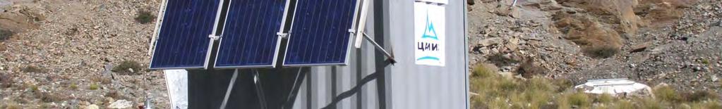
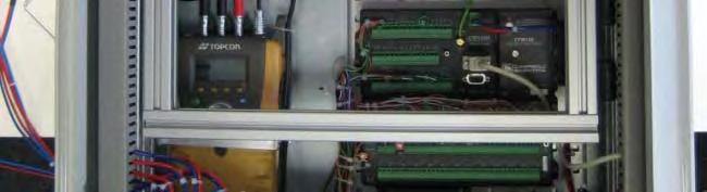
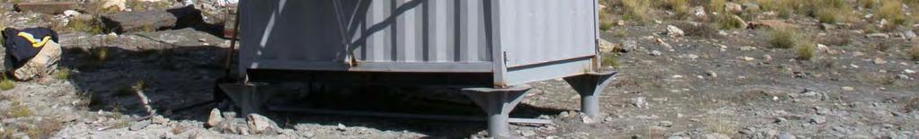

13 HyMet Station


14 SOPAF Architecture Databases - Metadata - Geodata - Meteodata User
15 SOPAF GUI for Station Control


16 Databases SOPAF Metadatabase Geodatabase. Information System ERROR PAGE Access denied Uzbekistan Tajikistan/Uzbekistan Kyrgyzstan decision maker decision maker decision maker
17 Information System GUI
18 Selected Activities Regional Climate Model


19 Climate Change in Central Asia I Change in summer temperature Period A2 Scenario
20 Climate Change in Central Asia II Relative changes in precipitation for the period , relative to


21 Regional Climate Model REMO Scale Boundary and initial values Global Circulation Model Regional climate model REMO ~200 km Circulation patterns Statistical downscaling ~18 km Observation data Any other Source: DWD Source: adapted from PIK
22 Regional Climate Model Area REMO , A1B and A2 scenarios, 3 ensemble members
?")

 REMO")
23 Postprocessing of REMO Data meteorological station (local)? hydrological model MOS & Weather Generator? distribution of daily rainfall REMO grid box (18km x 18km) REMO original station data REMO postprocessed
24 Selected Activities Hydrological Model


25 Climate and Hydrologic Models Regional Climate Model REMO Hydrological Model WASA Scenarios of water availability up to 2100

26 Hydrological Model WASA Climate forcing River basin water balance Model output: Time series of water availability variables Processes represented in WASA: Infiltration Soil water movement Evapotranspiration Runoff generation Runoff routing in river network Retention in reservoirs Model extension in CAWA project: Snow melt Glacier mass balances


27 Hydrological Model WASA Examples of required parameters Topography: Slope gradient Slope length River cross sections from Digital Elevation Models hillslope with terrain components Soil profile stream net twork TC 1 TC 2 TC 3


 47,000 km² from")
 11,700 km²")
")
28 Selected River Basins Catchment Outlet Gauge Drainage Area Data range Naryn Uchterek (Toktogul res.) 47,000 km² from 1963 Karadarya Uzgen (Andijan) 11,700 km² Zerafshan Dupulet (Penjikent) 10,200 km²
29 Selected Activities Use of Remote Sensing Technologies
30 Overview on Used Remote Sensing Data MODIS LANDSAT RapidEye TerraSAR-X Sensor type optical optical optical radar Parameters: LAI 8 d + Fractional Cover 8d + Albedo 16 d Land cover 1a + Vegetation height + Snow cover 1 d Glacier delineation 16 d d Spatial resolution 1 km m 6 m 1 16 m
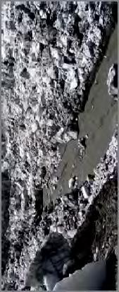
31 TerraSAR-X Data Inylchek Glacier with Merzbacher Lake (Kyrgyzstan), SM HH, ,5 1 1,5 2 Detailed view on Northern Inylchek Glacier with Merzbacher Lake Data: DLR (2008) TerraSAR-X D
32 Conclusion / Potential for Cooperation Covering the whole of Central Asia Monitoring system / Information system Integration of other stations, data bases, Integration of use cases Regional climate model downscaled for integration with hydrologic model Compare with results from other models or statistical approaches Coupling with water allocation model Remote sensing Cross validation with other models Water balance modeling linked to remote sensing based water use assessment integration of a large area Joint scientific proposals
Scientific component of Berlin Process (CAWa Project)
") Regional Research Network Central Asian Water Scientific component of Berlin Process (CAWa Project) Almas Kitapbayev, Abror Gafurov, Sarah Schönbrodt-Stitt, Lars Gerlitz Tashkent, 24.11.2017 CAWa Project
Regional Research Network Central Asian Water Scientific component of Berlin Process (CAWa Project) Almas Kitapbayev, Abror Gafurov, Sarah Schönbrodt-Stitt, Lars Gerlitz Tashkent, 24.11.2017 CAWa Project
Global Flash Flood Guidance System Status and Outlook
 Global Flash Flood Guidance System Status and Outlook HYDROLOGIC RESEARCH CENTER San Diego, CA 92130 http://www.hrcwater.org Initial Planning Meeting on the WMO HydroSOS, Entebbe, Uganda 26-28 September
CAWa Central Asian Water. Training Course Geographical Information Systems in Hydrology
 CAWa Central Asian Water Training Course Geographical Information Systems in Hydrology 1 Place & Time Place to hold the workshop: Helmholtz Centre Potsdam GFZ German Research Center for Geosciences, Germany
Hands On Applications of the Latin American and Caribbean Flood and Drought Monitor (LACFDM)
") Hands On Applications of the Latin American and Caribbean Flood and Drought Monitor (LACFDM) Colby Fisher, Eric F Wood, Justin Sheffield, Nate Chaney Princeton University International Training: Application
Hands On Applications of the Latin American and Caribbean Flood and Drought Monitor (LACFDM) Colby Fisher, Eric F Wood, Justin Sheffield, Nate Chaney Princeton University International Training: Application
Drought Monitoring with Hydrological Modelling
 st Joint EARS/JRC International Drought Workshop, Ljubljana,.-5. September 009 Drought Monitoring with Hydrological Modelling Stefan Niemeyer IES - Institute for Environment and Sustainability Ispra -
Monitoring and study of glacier systems in Kyrgyzstan under conditions of climate change (under the CAWa and GCO projects)
") Central Asian Institute of Applied Geosciences Joint NASA LCLUC Science Team Meeting with GOFC-GOLD CARIN, NEESPI and MAIRS on Land Use and Water Resources in Central Asia Monitoring and study of glacier
Central Asian Institute of Applied Geosciences Joint NASA LCLUC Science Team Meeting with GOFC-GOLD CARIN, NEESPI and MAIRS on Land Use and Water Resources in Central Asia Monitoring and study of glacier
Hydrologic Modelling of the Upper Malaprabha Catchment using ArcView SWAT
 Hydrologic Modelling of the Upper Malaprabha Catchment using ArcView SWAT Technical briefs are short summaries of the models used in the project aimed at nontechnical readers. The aim of the PES India
CAIAG actions on high elevation observations in Kyrgyzstan
 CAIAG actions on high elevation observations in Kyrgyzstan Project structure Aim of the project Water in Central Asia covers study of principal components of the water resources in Kyrgyzstan. One of
Coping with International Water Conflict in Central Asia ~ Implications of Climate Change and Melting Ice in the Syr Darya Catchment *
 Coping with International Water Conflict in Central Asia ~ Implications of Climate Change and Melting Ice in the Syr Darya Catchment * *: Partially funded by NOAA CORC ARCHES. Tobias Siegfried, Thomas
INTRODUCTION TO HEC-HMS
 INTRODUCTION TO HEC-HMS Hydrologic Engineering Center- Hydrologic Modeling System US Army Corps of Engineers Hydrologic Engineering Center HEC-HMS Uses Schematics Enter properties: watershed, rivers (reaches),
Flood Forecasting Tools for Ungauged Streams in Alberta: Status and Lessons from the Flood of 2013
 Flood Forecasting Tools for Ungauged Streams in Alberta: Status and Lessons from the Flood of 2013 John Pomeroy, Xing Fang, Kevin Shook, Tom Brown Centre for Hydrology, University of Saskatchewan, Saskatoon
Haiti and Dominican Republic Flash Flood Initial Planning Meeting
 Dr Rochelle Graham Climate Scientist Haiti and Dominican Republic Flash Flood Initial Planning Meeting September 7 th to 9 th, 2016 Hydrologic Research Center http://www.hrcwater.org Haiti and Dominican
International Workshop on the Northern Eurasia High Mountain Ecosystems.
 International Workshop on the Northern Eurasia High Mountain Ecosystems B.Moldobekov, H.Echtler HEchtler http://www.caiag.kg Bishkek, Kyrgyzstan September 8-15, 2009 GFZ: Focus on Central Asia 1992 Space
Basin characteristics
 Basin characteristics From hydrological processes at the point scale to hydrological processes throughout the space continuum: point scale à river basin The watershed characteristics (shape, length, topography,
Hydrological change in the. regions of Central Asia
 Hydrological change in the mountainous and downstream regions of Central Asia Alexander I. Shiklomanov Water Systems Analysis Group University of New Hampshire International Workshop on the Northern Eurasia
Regional Flash Flood Guidance and Early Warning System
 WMO Training for Trainers Workshop on Integrated approach to flash flood and flood risk management 24-28 October 2010 Kathmandu, Nepal Regional Flash Flood Guidance and Early Warning System Dr. W. E. Grabs
ESTIMATING SNOWMELT CONTRIBUTION FROM THE GANGOTRI GLACIER CATCHMENT INTO THE BHAGIRATHI RIVER, INDIA ABSTRACT INTRODUCTION
 ESTIMATING SNOWMELT CONTRIBUTION FROM THE GANGOTRI GLACIER CATCHMENT INTO THE BHAGIRATHI RIVER, INDIA Rodney M. Chai 1, Leigh A. Stearns 2, C. J. van der Veen 1 ABSTRACT The Bhagirathi River emerges from
An Overview of Operations at the West Gulf River Forecast Center Gregory Waller Service Coordination Hydrologist NWS - West Gulf River Forecast Center
 National Weather Service West Gulf River Forecast Center An Overview of Operations at the West Gulf River Forecast Center Gregory Waller Service Coordination Hydrologist NWS - West Gulf River Forecast
APPLICATIONS OF DOWNSCALING: HYDROLOGY AND WATER RESOURCES EXAMPLES
 APPLICATIONS OF DOWNSCALING: HYDROLOGY AND WATER RESOURCES EXAMPLES Dennis P. Lettenmaier Department of Civil and Environmental Engineering For presentation at Workshop on Regional Climate Research NCAR
Uncertainty in the SWAT Model Simulations due to Different Spatial Resolution of Gridded Precipitation Data
 Uncertainty in the SWAT Model Simulations due to Different Spatial Resolution of Gridded Precipitation Data Vamsi Krishna Vema 1, Jobin Thomas 2, Jayaprathiga Mahalingam 1, P. Athira 4, Cicily Kurian 1,
Amita Mehta and Ana Prados
 Building Capacity in Utilizing NASA Remote Sensing Observations in SWAT for Water Resources and Agricultural Management Applications Amita Mehta and Ana Prados NASA - University of Maryland Baltimore County
METRIC tm. Mapping Evapotranspiration at high Resolution with Internalized Calibration. Shifa Dinesh
 METRIC tm Mapping Evapotranspiration at high Resolution with Internalized Calibration Shifa Dinesh Outline Introduction Background of METRIC tm Surface Energy Balance Image Processing Estimation of Energy
Monitoring Land Cover and Land Use in Central Asia Remote Sensing Contributions from selected German projects
 Monitoring Land Cover and Land Use in Central Asia Remote Sensing Contributions from selected German projects NASA LCLUC Meeting, Tashkent, 11.-13.11.2013 Christopher Conrad University of Würzburg, Institute
Building a European-wide hydrological model
 Building a European-wide hydrological model 2010 International SWAT Conference, Seoul - South Korea Christine Kuendig Eawag: Swiss Federal Institute of Aquatic Science and Technology Contribution to GENESIS
12 SWAT USER S MANUAL, VERSION 98.1
 12 SWAT USER S MANUAL, VERSION 98.1 CANOPY STORAGE. Canopy storage is the water intercepted by vegetative surfaces (the canopy) where it is held and made available for evaporation. When using the curve
NOAA s National Weather Service
 NOAA s National Weather Service Colorado Basin River Forecast Center Developing Climate-Informed Ensemble Streamflow Forecasts over the Colorado River Basin W. Paul Miller Colorado Basin River Forecast
Modelling changes in the runoff regime in Slovakia using high resolution climate scenarios
 Modelling changes in the runoff regime in Slovakia using high resolution climate scenarios K. HLAVČOVÁ, R. VÝLETA, J. SZOLGAY, S. KOHNOVÁ, Z. MACUROVÁ & P. ŠÚREK Department of Land and Water Resources
Statistical picture of climate changes in Central Asia: Temperature, precipitation, and river flow
 International Environmental Modelling and Software Society (iemss) 2010 International Congress on Environmental Modelling and Software Modelling for Environment s Sake, Fifth Biennial Meeting, Ottawa,
Hydrological modelling of the Lena River using SWIM
 Hydrological modelling of the Lena River using SWIM Michel Wortmann 1 1 Potsdam Institute for Climate Impact Research (PIK), Germany July 8, 214 Contents 1 The Lena catchment and data used 1 1.1 Discharge
Snow and glacier change modelling in the French Alps
 International Network for Alpine Research Catchment Hydrology Inaugural Workshop Barrier Lake Field Station, Kananaskis Country, Alberta, Canada 22-24 October 2015 Snow and glacier change modelling in
Flash Flood Guidance System On-going Enhancements
 Flash Flood Guidance System On-going Enhancements Hydrologic Research Center, USA Technical Developer SAOFFG Steering Committee Meeting 1 10-12 July 2017 Jakarta, INDONESIA Theresa M. Modrick Hansen, PhD
Report on cryosphere related activity in Uzbekistan.
 Report on cryosphere related activity in Uzbekistan. CryoNet Asia Workshop (The second Session) Salekhard, 2 5 February 2016 Klimentiy Valiev Centre of Hydrometeorological Service at Cabinet of Ministers
Transactions on Information and Communications Technologies vol 18, 1998 WIT Press, ISSN
 STREAM, spatial tools for river basins, environment and analysis of management options Menno Schepel Resource Analysis, Zuiderstraat 110, 2611 SJDelft, the Netherlands; e-mail: menno.schepel@resource.nl
Modelling snow accumulation and snow melt in a continuous hydrological model for real-time flood forecasting
 IOP Conference Series: Earth and Environmental Science Modelling snow accumulation and snow melt in a continuous hydrological model for real-time flood forecasting To cite this article: Ph Stanzel et al
Operational Hydrologic Ensemble Forecasting. Rob Hartman Hydrologist in Charge NWS / California-Nevada River Forecast Center
 Operational Hydrologic Ensemble Forecasting Rob Hartman Hydrologist in Charge NWS / California-Nevada River Forecast Center Mission of NWS Hydrologic Services Program Provide river and flood forecasts
FFGS Concept HYDROLOGIC RESEARCH CENTER. 2 May 2017
 FFGS Concept HYDROLOGIC RESEARCH CENTER 2 May 2017 Research and Development History 1970-1988: US NWS Produces FFG statistically for each River Forecast Center. Also, research in adaptive site specific
Towards a probabilistic hydrological forecasting and data assimilation system. Henrik Madsen DHI, Denmark
 Towards a probabilistic hydrological forecasting and data assimilation system Henrik Madsen DHI, Denmark Outline Hydrological forecasting Data assimilation framework Data assimilation experiments Concluding
VIC Hydrology Model Training Workshop Part II: Building a model
 VIC Hydrology Model Training Workshop Part II: Building a model 11-12 Oct 2011 Centro de Cambio Global Pontificia Universidad Católica de Chile Ed Maurer Civil Engineering Department Santa Clara University
Seasonal and interannual relations between precipitation, soil moisture and vegetation in the North American monsoon region
 Seasonal and interannual relations between precipitation, soil moisture and vegetation in the North American monsoon region Luis A. Mendez-Barroso 1, Enrique R. Vivoni 1, Christopher J. Watts 2 and Julio
EVALUATION AND MONITORING OF SNOWCOVER WATER RESOURCES IN CARPATHIAN BASINS USING GEOGRAPHIC INFORMATION AND SATELLITE DATA
 EVALUATION AND MONITORING OF SNOWCOVER WATER RESOURCES IN CARPATHIAN BASINS USING GEOGRAPHIC INFORMATION AND SATELLITE DATA Gheorghe Stancalie, Simona Catana, Anisoara Iordache National Institute of Meteorology
The Importance of Snowmelt Runoff Modeling for Sustainable Development and Disaster Prevention
 The Importance of Snowmelt Runoff Modeling for Sustainable Development and Disaster Prevention Muzafar Malikov Space Research Centre Academy of Sciences Republic of Uzbekistan Water H 2 O Gas - Water Vapor
Speakers: NWS Buffalo Dan Kelly and Sarah Jamison, NERFC Jeane Wallace. NWS Flood Services for the Black River Basin
 Speakers: NWS Buffalo Dan Kelly and Sarah Jamison, NERFC Jeane Wallace NWS Flood Services for the Black River Basin National Weather Service Who We Are The National Oceanic and Atmospheric Administration
Hydrologic Overview & Quantities
 Hydrologic Overview & Quantities It is important to understand the big picture when attempting to forecast. This includes the interactive components and hydrologic quantities. Hydrologic Cycle The complexity
Land Surface: Snow Emanuel Dutra
 Land Surface: Snow Emanuel Dutra emanuel.dutra@ecmwf.int Slide 1 Parameterizations training course 2015, Land-surface: Snow ECMWF Outline Snow in the climate system, an overview: Observations; Modeling;
Climate Change or Climate Variability?
 Climate Change or Climate Variability? Key Concepts: Greenhouse Gas Climate Climate change Climate variability Climate zones Precipitation Temperature Water cycle Weather WHAT YOU WILL LEARN 1. You will
CHAPTER VII FULLY DISTRIBUTED RAINFALL-RUNOFF MODEL USING GIS
 80 CHAPTER VII FULLY DISTRIBUTED RAINFALL-RUNOFF MODEL USING GIS 7.1GENERAL This chapter is discussed in six parts. Introduction to Runoff estimation using fully Distributed model is discussed in first
Supplementary Materials for
 advances.sciencemag.org/cgi/content/full/3/12/e1701169/dc1 Supplementary Materials for Abrupt shift in the observed runoff from the southwestern Greenland ice sheet Andreas P. Ahlstrøm, Dorthe Petersen,
SNOW AND GLACIER HYDROLOGY
 SNOW AND GLACIER HYDROLOGY by PRATAP SINGH National Institute of Hydrology, Roorkee, India and VIJAY P. SINGH Department of Civil and Environmental Engineering, Louisiana State University, Baton Rouge,
Surface Processes Focus on Mass Wasting (Chapter 10)
") Surface Processes Focus on Mass Wasting (Chapter 10) 1. What is the distinction between weathering, mass wasting, and erosion? 2. What is the controlling force in mass wasting? What force provides resistance?
Surface Processes Focus on Mass Wasting (Chapter 10) 1. What is the distinction between weathering, mass wasting, and erosion? 2. What is the controlling force in mass wasting? What force provides resistance?
Overview of Data for CREST Model
 Overview of Data for CREST Model Xianwu Xue April 2 nd 2012 CREST V2.0 CREST V2.0 Real-Time Mode Forcasting Mode Data Assimilation Precipitation PET DEM, FDR, FAC, Slope Observed Discharge a-priori parameter
MODULE 7 LECTURE NOTES 5 DRAINAGE PATTERN AND CATCHMENT AREA DELINEATION
 MODULE 7 LECTURE NOTES 5 DRAINAGE PATTERN AND CATCHMENT AREA DELINEATION 1. Introduction Topography of the river basin plays an important role in hydrologic modelling, by providing information on different
Measures Also Significant Factors of Flood Disaster Reduction
 Non-Structual Measures Also Significant Factors of Flood Disaster Reduction Babiaková Gabriela, Leškov ková Danica Slovak Hydrometeorological Institute, Bratislava Hydrological Forecasts and Warning Department
Impacts of climate change on flooding in the river Meuse
 Impacts of climate change on flooding in the river Meuse Martijn Booij University of Twente,, The Netherlands m.j.booij booij@utwente.nlnl 2003 in the Meuse basin Model appropriateness Appropriate model
UGRC 144 Science and Technology in Our Lives/Geohazards
 UGRC 144 Science and Technology in Our Lives/Geohazards Flood and Flood Hazards Dr. Patrick Asamoah Sakyi Department of Earth Science, UG, Legon College of Education School of Continuing and Distance Education
Cryosphere matters attribution of observed streamflow changes in headwater catchments of the Tarim River
 Cryosphere matters attribution of observed streamflow changes in headwater catchments of the Tarim River Doris Düthmann, Tobias Bolch *, Tino Pieczonka *, Daniel Farinotti, David Kriegel, Sergiy Vorogushyn,
REQUIREMENTS FOR WEATHER RADAR DATA. Review of the current and likely future hydrological requirements for Weather Radar data
 WORLD METEOROLOGICAL ORGANIZATION COMMISSION FOR BASIC SYSTEMS OPEN PROGRAMME AREA GROUP ON INTEGRATED OBSERVING SYSTEMS WORKSHOP ON RADAR DATA EXCHANGE EXETER, UK, 24-26 APRIL 2013 CBS/OPAG-IOS/WxR_EXCHANGE/2.3
A GIS View of Hydrology
 Quantitative Elements of Hydrology A GIS View of Hydrology Contact information: Jack Hermance Environmental Geophysics/Hydrology Department of Geological Sciences Brown University, Providence, RI 02912-1846
Assimilation of satellite derived soil moisture for weather forecasting
 Assimilation of satellite derived soil moisture for weather forecasting www.cawcr.gov.au Imtiaz Dharssi and Peter Steinle February 2011 SMOS/SMAP workshop, Monash University Summary In preparation of the
EFFICIENCY OF THE INTEGRATED RESERVOIR OPERATION FOR FLOOD CONTROL IN THE UPPER TONE RIVER OF JAPAN CONSIDERING SPATIAL DISTRIBUTION OF RAINFALL
 EFFICIENCY OF THE INTEGRATED RESERVOIR OPERATION FOR FLOOD CONTROL IN THE UPPER TONE RIVER OF JAPAN CONSIDERING SPATIAL DISTRIBUTION OF RAINFALL Dawen YANG, Eik Chay LOW and Toshio KOIKE Department of
Satellite data for hydrological forecasting
 Satellite data for hydrological forecasting Current use at ECMWF and perspective Shopping list! Our current tools does not allow direct use, but could be modified Christel Prudhomme Christel.prudhomme@ecmwf.int
Drainage Basin Geomorphology. Nick Odoni s Slope Profile Model
 Drainage Basin Geomorphology Nick Odoni s Slope Profile Model Odoni s Slope Profile Model This model is based on solving the mass balance (sediment budget) equation for a hillslope profile This is achieved
Robert Shedd Northeast River Forecast Center National Weather Service Taunton, Massachusetts, USA
 Robert Shedd Northeast River Forecast Center National Weather Service Taunton, Massachusetts, USA Outline River Forecast Centers FEWS Implementation Status Forcing Data Ensemble Forecasting The Northeast
Simulation of sedimentation rates using the SWAT model A case study of the Tarbela Dam, Upper Indus Basin
 Simulation of sedimentation rates using the SWAT model A case study of the Tarbela Dam, Upper Indus Basin Ahammad, H. I 1., Crosato A 2,3., Maskey, S 2., Masih, I 2,*, McClain, M 2. 1 Punjab Irrigation
Development of the Hydrologic Model
 Kick-off meeting on enhancing hydrological data management and exchange procedures Water and Climate Adaptation Plan (WATCAP) for Sava River Basin Development of the Hydrologic Model David Heywood Team
Towards more integrated research and observation in the Alps. The Bavarian Academy of Sciences and Humanities and its
 Towards more integrated research and observation in the Alps The Bavarian Academy of Sciences and Humanities and its Commission i for Glaciology l Our activities in Alpine Research Towards more integrated
Hydrologic and Hydraulic Analyses Using ArcGIS
 Hydrologic and Hydraulic Analyses Using ArcGIS Two day training class Overview ArcGIS and Arc Hydro provide strong foundation for support of hydrologic and hydraulic (H&H) analyses. This two-day course
Appendix D. Model Setup, Calibration, and Validation
 . Model Setup, Calibration, and Validation Lower Grand River Watershed TMDL January 1 1. Model Selection and Setup The Loading Simulation Program in C++ (LSPC) was selected to address the modeling needs
Near Real-Time Runoff Estimation Using Spatially Distributed Radar Rainfall Data. Jennifer Hadley 22 April 2003
 Near Real-Time Runoff Estimation Using Spatially Distributed Radar Rainfall Data Jennifer Hadley 22 April 2003 Introduction Water availability has become a major issue in Texas in the last several years,
5.1 Table of contents (Greek group from Patras)
") 5 Greek Part Patras 5.1 Table of contents (Greek group from Patras) 5.1 Table of contents (Greek group from Patras)... 5-3 5.2 Study area... 5-4 5.3 Methodology... 5-4 5.3.1 Downscaling classification
5 Greek Part Patras 5.1 Table of contents (Greek group from Patras) 5.1 Table of contents (Greek group from Patras)... 5-3 5.2 Study area... 5-4 5.3 Methodology... 5-4 5.3.1 Downscaling classification
FROM FLOOD FORECAST TO FLOOD FIGHTING Georg Johann , Tiel
 FROM FLOOD FORECAST TO FLOOD FIGHTING Georg Johann 2016-11-04, Tiel Dutch-German exchange of knowledge and experience COMING FROM FORECASTS TO EFFECTIVE FLOOD DEFENDING EMERGENCY MEASURES Flood forecasting
WegenerNet: A new climate station network in Eastern Styria/Austria for monitoring weather and climate at 1 km-scale resolution
 Session GI 2 Atmosphere, Ocean, Meteorological Instruments and Ocean Observatory Instrumentation ; EGU General Assembly 2008; 13-18 Apr 2008, Vienna, Austria. WegenerNet: A new climate station network
CARFFG System Development and Theoretical Background
 CARFFG Steering Committee Meeting 15 SEPTEMBER 2015 Astana, KAZAKHSTAN CARFFG System Development and Theoretical Background Theresa M. Modrick, PhD Hydrologic Research Center Key Technical Components -
Real-Time Meteorological Gridded Data: What s New With HEC-RAS
 Real-Time Meteorological Gridded Data: What s New With HEC-RAS Acquisition and Application of Gridded Meteorological Data in Support of the USACE s Real-Time Water Management Mission Fauwaz Hanbali, Tom
REAL-TIME WATER RESOURCE MANAGEMENT SYSTEM IN MEKONG RIVER SYSTEM
 REAL-TIME WATER RESOURCE MANAGEMENT SYSTEM IN MEKONG RIVER SYSTEM Narumitr Sawangphol 1, Sombat Yumuang 2, Thavivongse Sriburi 3 and Anond Snidvongs 4 1 Southeast Asia START Regional Center. c/o Environmental
Water Resources of Central Asia: Contemporary Status and Future Projections
 Water Resources of Central Asia: Contemporary Status and Future Projections Natalya Agaltseva 1, Alexander Shiklomanov 2 1-Hydrometeorological Research Institute, Uzydromet, Tashkent 2-Water Systems Analysis
Operational water balance model for Siilinjärvi mine
 Operational water balance model for Siilinjärvi mine Vesa Kolhinen, Tiia Vento, Juho Jakkila, Markus Huttunen, Marie Korppoo, Bertel Vehviläinen Finnish Environment Institute (SYKE) Freshwater Centre/Watershed
Lake Tahoe Watershed Model. Lessons Learned through the Model Development Process
 Lake Tahoe Watershed Model Lessons Learned through the Model Development Process Presentation Outline Discussion of Project Objectives Model Configuration/Special Considerations Data and Research Integration
Modelling runoff from large glacierized basins in the Karakoram Himalaya using remote sensing of the transient snowline
 Remote Sensing and Hydrology 2000 (Proceedings of a symposium held at Santa Fe, New Mexico, USA, April 2000). IAHS Publ. no. 267, 2001. 99 Modelling runoff from large glacierized basins in the Karakoram
The WegenerNet observing weather and climate at 1 km-scale resolution: a new look at convective precipitation and other local-scale processes
 The WegenerNet observing weather and climate at 1 km-scale resolution: a new look at convective precipitation and other local-scale processes G. Kirchengast, T. Kabas, A. Leuprecht, C. Stieb, and C. Bichler
Flash flood forecasting and warning infrastructures of National Meteorology and Hydrological Services of Cambodia
 Development and Implementation of the South East Asia Flash Flood Guidance System (SEAFFGS) Ha Noi, Viet Nam, 20-23 November 2017 Flash flood forecasting and warning infrastructures of National Meteorology
Overview of the current status of application of GIS and RS in soil and water management in Republic of Macedonia
 Overview of the current status of application of GIS and RS in soil and water management in Republic of Macedonia Dr. Dusko Mukaetov Institute of Agriculture Blvd. Aleksandar Makedonski b.b., 1000 Skopje,
Inter-linkage case study in Pakistan
 7 th GEOSS Asia Pacific Symposium GEOSS AWCI Parallel Session: 26-28 May, 2014, Tokyo, Japan Inter-linkage case study in Pakistan Snow and glaciermelt runoff modeling in Upper Indus Basin of Pakistan Maheswor
Existing GIS Resources on the Indus Basin
 Existing GIS Resources on the Indus Basin Workshop on Spatial Information Analysis for the Sustainable Management of the Indus Basin in Pakistan May 26-27, 2003 Elements of Existing GIS Resources Data
FFGS Additional Functionalities and Products. Konstantine P. Georgakakos, Sc.D. HYDROLOGIC RESEARCH CENTER 23 May 2018
 FFGS Additional Functionalities and Products Konstantine P. Georgakakos, Sc.D. HYDROLOGIC RESEARCH CENTER 23 May 2018 Advanced Functionalities 0. Multi-Model QPF A. Urban Flash Flood Warning B. Riverine
How to integrate wetland processes in river basin modeling? A West African case study
 How to integrate wetland processes in river basin modeling? A West African case study stefan.liersch@pik-potsdam.de fred.hattermann@pik-potsdam.de June 2011 Outline Why is an inundation module required?
THE RAINWATER HARVESTING SYMPOSIUM 2015
 THE RAINWATER HARVESTING SYMPOSIUM 2015 Remote Sensing for Rainwater Harvesting and Recharge Estimation under Data Scarce Conditions Taye Alemayehu Ethiopian Institute of Water Resources, Metameta Research
Land Data Assimilation at NCEP NLDAS Project Overview, ECMWF HEPEX 2004
 Dag.Lohmann@noaa.gov, Land Data Assimilation at NCEP NLDAS Project Overview, ECMWF HEPEX 2004 Land Data Assimilation at NCEP: Strategic Lessons Learned from the North American Land Data Assimilation System
Influence of rainfall space-time variability over the Ouémé basin in Benin
 102 Remote Sensing and GIS for Hydrology and Water Resources (IAHS Publ. 368, 2015) (Proceedings RSHS14 and ICGRHWE14, Guangzhou, China, August 2014). Influence of rainfall space-time variability over
MODULE 8 LECTURE NOTES 2 REMOTE SENSING APPLICATIONS IN RAINFALL-RUNOFF MODELLING
 MODULE 8 LECTURE NOTES 2 REMOTE SENSING APPLICATIONS IN RAINFALL-RUNOFF MODELLING 1. Introduction The most common application of the remote sensing techniques in the rainfall-runoff studies is the estimation
Using MODIS imagery to validate the spatial representation of snow cover extent obtained from SWAT in a data-scarce Chilean Andean watershed
 Using MODIS imagery to validate the spatial representation of snow cover extent obtained from SWAT in a data-scarce Chilean Andean watershed Alejandra Stehr 1, Oscar Link 2, Mauricio Aguayo 1 1 Centro
Arkansas-Red Basin River Forecast Center Operations. RRVA Conference Durant, OK 8/22/2013 Jeff McMurphy Sr. Hydrologist - ABRFC
 Arkansas-Red Basin River Forecast Center Operations RRVA Conference Durant, OK 8/22/2013 Jeff McMurphy Sr. Hydrologist - ABRFC NWS River Forecast Centers NWS Weather Forecast Offices Operations Staffing
Study of Hydrometeorology in a Hard Rock Terrain, Kadirischist Belt Area, Anantapur District, Andhra Pradesh
 Open Journal of Geology, 2012, 2, 294-300 http://dx.doi.org/10.4236/ojg.2012.24028 Published Online October 2012 (http://www.scirp.org/journal/ojg) Study of Hydrometeorology in a Hard Rock Terrain, Kadirischist
Assessing climate change impacts on the water resources in Pune, India, using downscaling and hydrologic modeling
 Assessing climate change impacts on the water resources in Pune, India, using downscaling and hydrologic modeling 1, Tim G. Reichenau 1, Shamita Kumar 2, Karl Schneider 1 1 Hydrogeography and Climatology
Heihe River Runoff Prediction
 Heihe River Runoff Prediction Principles & Application Dr. Tobias Siegfried, hydrosolutions Ltd., Zurich, Switzerland September 2017 hydrosolutions Overview Background Methods Catchment Characterization
Hydrologic Engineering Applications of Geographic Information Systems
 Hydrologic Engineering Applications of Geographic Information Systems Davis, California Objectives: The participant will acquire practical knowledge and skills in the application of GIS technologies for
Analysis of real-time prairie drought monitoring and forecasting system. Lei Wen and Charles A. Lin
 Analysis of real-time prairie drought monitoring and forecasting system Lei Wen and Charles A. Lin Back ground information A real-time drought monitoring and seasonal prediction system has been developed
Colorado River Management under Uncertainty
 Colorado River Management under Uncertainty Terry Fulp Deputy Regional Director Lower Colorado Region WRRC Annual Meeting June 24, 2008 Colorado River Management under Uncertainty Overview of Colorado
Together4Water project. Implementing an open-source database to monitor water-related SDG in Tunisia
 Linked Open Data in Agriculture Together4Water project Implementing an open-source database to monitor water-related SDG in Tunisia Ir. Raed Fehri Supervisors: Prof. Marnik Vanclooster Prof. Kim Mens Berlin,
Flood Inundation Mapping under different climate change scenarios in the upper Indus River Basin, Pakistan
 Flood Inundation Mapping under different climate change scenarios in the upper Indus River Basin, Pakistan Sohaib Baig (doctoral student) 16 November 2017 Disaster Prevention Research Institute 1 Kyoto
Climate Change Impacts on the Upstream Water Resources of the Amu and Syr Darya River Basins
 Climate Change Impacts on the Upstream Water Resources of the Amu and Syr Darya River Basins March 2012 Authors W.W. Immerzeel A.F. Lutz P. Droogers Client Asian Development Bank Report FutureWater: 107