Speakers: NWS Buffalo Dan Kelly and Sarah Jamison, NERFC Jeane Wallace. NWS Flood Services for the Black River Basin
|
|
|
- Naomi Andrews
- 5 years ago
- Views:
Transcription

1 Speakers: NWS Buffalo Dan Kelly and Sarah Jamison, NERFC Jeane Wallace NWS Flood Services for the Black River Basin


2 National Weather Service Who We Are The National Oceanic and Atmospheric Administration (NOAA) conducts research and gathers data about the global oceans, atmosphere, space and sun, and applies this knowledge to science and services that touch the lives of all Americans. The National Weather Service is the primary source of weather data, forecasts and warnings for the United States. The NWS is the sole United States official voice for issuing warnings during life-threatening weather situations.

3 National Weather Service Overview The National Weather Service (NWS) is responsible for weather watches, warnings, and advisories as well as forecasts several times daily.

4 13 River Forecast Centers Our Mission: To provide our nation with river, flood and water resource forecasts for the protection of life and property and the enhancement of the national economy.

 and warnings for 16 counties in western, central and northern NY.")
5 National Weather Service Weather Forecast Office Buffalo NY Located on the east side of the Buffalo Niagara International Airport Staffed 24/7/365 by 22 Meteorologists, Electronic Technicians and Support Staff One of 92 stations in the United States and ~500 sites around the world that launch a weather balloon twice per day. We are responsible for forecasts (including marine and airport) and warnings for 16 counties in western, central and northern NY. Take the official snow readings for Buffalo

6 NWS Services River Forecasting NWS RFC NWS & RFC Data Collection River Forecasting CHPS Model Final Forecast AHPS
7 NWS Services Roles and Responsibilities NWS BUF Daily Forecasts Watch/Warnings/Advisories Maintain observing climate stations Work with partners to expand observing networks Collect snow information Issuance of RFC river forecasts and warnings Maintain River and Lakes AHPS webpage Decision Support Services to core users RFC Calibrate and implement variety of hydrologic and hydraulic models and produce temperature and precipitation forecasts to provide: River flow and stage forecasts at 2 locations Guidance on the rainfall needed to produce Flash Flooding Ensemble streamflow predictions Ice Jam and Dam Break support Water Supply forecasts Reservoir Inflow Forecasts
8 NWS Services Flood Products and Definitions Hazardous Weather Outlook (HWO) Discuss the potential for flooding (Timeframe: 3 to 5 day) Flood Watch 50% confidence that flooding will occur. (Timeframe: A Day or Two) Flood Warning Flooding is imminent, 80% or greater confidence. (Timeframe: hours) Flood Warning (river) Issued for a specific river and forecast point. Flood Warning (areal) Issued for an area for expected flooding not at a forecast point (non-gauged waterways, severe ponding, closed roads) Flash Flood Warning Issued for rapidly rising waters which pose an immediate risk to life or property (washouts, floating cars, rescues, etc).

9 NWS Services River Forecasting

10 Forecasting River Rises and Discharges River Forecast Information

11 Forecasting River Rises and Discharges River Forecast Information
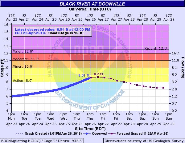

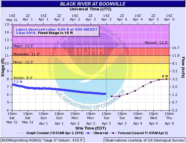
12 Forecasting River Rises and Discharges River Forecast Information

13 Forecasting River Rises and Discharges River Gauges The NWS does not operate river gauges in the Black River Basin. NWS works with local, county, and federal partners to develop river gauge observation and forecast points

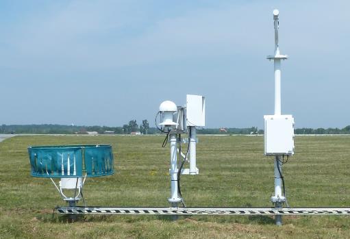
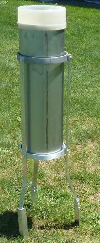
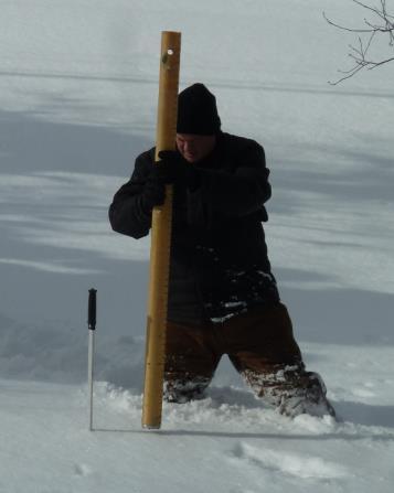
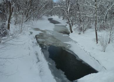
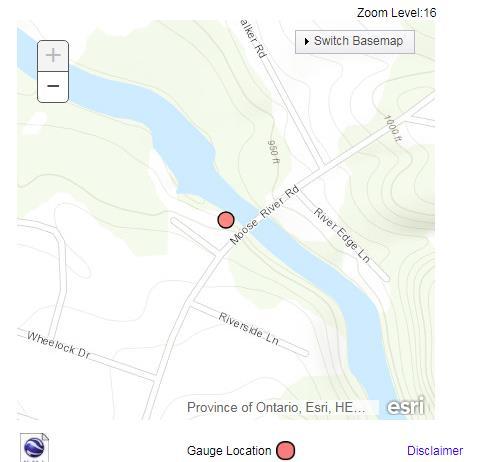
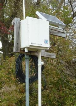
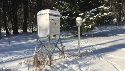
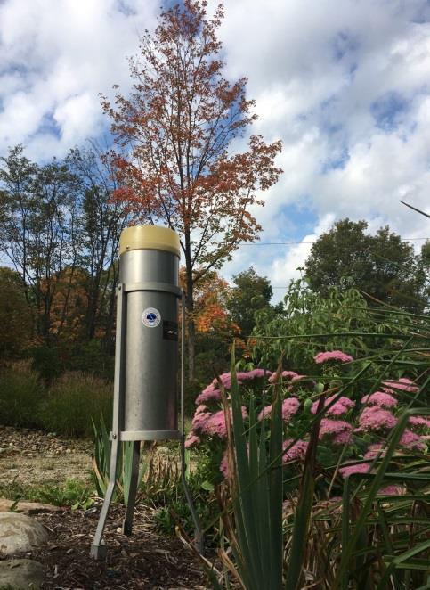
14 Observing sites in Lewis and Jefferson Counties

15 Lewis County Gauging Locations

16 Forecasting River Rises and Discharges River Forecast Points in the Black River Basin There are three official forecast points for the Black River Basin- 1. Black River at Boonville 2. Moose River at McKeever 3. Black River at Watertown Forecasts are updated 3 times a day

17 Current River Flood Warning Polygons
18 Proposed FLW Polygons
19 Forecasting River Rises and Discharges Establishing a River Forecast Point In order to establish a forecast point: 1. There needs to be a user request and real-time data 2. Then the NWS Buffalo coordinates with the River Forecast Center (RFC) to add the point and to ingest the data. 3. The RFC has adds the point and begins the testing phase. 1. This takes time because in order to properly test it, they need to see how forecasts work out with high flows. 2. Testing typically takes 6-12 months. 3. While this is being done, we prepare our operations for the forecast point, including developing warning areas and standard impact statements. 4. Once the testing is done, we send out a formal notice and after 30 days we begin issuing the forecast daily. Dadville is presently in the testing phase. What we need now is feedback on the impact statements what floods at what river stages. These levels and impacts can be adjusted in the future if need be.
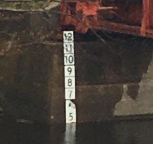
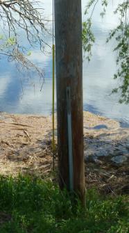
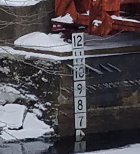
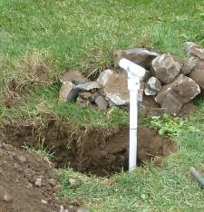
20 Forecasting River Rises and Discharges Dadville River Gauges +~3.5
21 Preliminary impact statements for Dadville


22 Forecasting River Rises and Discharges Snowfall Measurements


23 Northeast River Forecast Center Operations & Services


24 River Forecast Center Responsibilities Calibrate and implement variety of hydrologic and hydraulic models and produce temperature and precipitation forecasts to provide: River flow and stage forecasts at 200 locations Guidance on the rainfall needed to produce Flash Flooding Ensemble streamflow predictions Ice Jam and Dam Break support Water Supply forecasts Reservoir Inflow Forecasts Moderate flooding - Connecticut River at Portland, CT.

25 Forecast Services On A Watershed Scale Requirements: Observed precipitation & temperatures Observed streamflows (USGS) Forecast temperatures and precipitation Drainage area > 100 sq mi Our models help us forecast: The volume of water in the river & that s converted to stage/elevation Time of the peak elevation & duration Soil moisture & Snow melt Unit hydrograph theory Reservoir Operations (RES-J) Hydraulics (HEC-RAS) for complex river systems Tidal reaches Lake Champlain, Farmington River Combines tidal/storm surge with fresh water runoff on 5 tidal rivers # //STATION NAME="BLACK RIVER AT DADVILLE NY" # //LABEL="Discharge ft^3/s" # //PARAMETER CODE="00060" # //RATING ID="40.0" TYPE="STGQ" NAME="stage-discharge" AGING=Working # //RATING REMARKS="At and above 7.30 ft identical w/ rat 39" # //RATING EXPANSION="logarithmic" # //RATING BREAKPOINT1= E+00 BREAKPOINT2= E+00 # //RATING OFFSET1= E+00 OFFSET2= E+00 OFFSET3= E+00 # //RATING_INDEP ROUNDING="????" PARAMETER="Gage height (ft)" # //RATING_DEP ROUNDING="????" PARAMETER="Discharge (ft^3/s)" # //RATING_DATETIME BEGIN= BZONE=-05:00 END= EZONE=-05:00 AGING=None # //RATING_DATETIME COMMENT="" # //RATING_DATETIME BEGIN= BZONE=-05:00 END= EZONE=--- AGING=Working # //RATING_DATETIME COMMENT="" INDEP SHIFT DEP STOR 16N 16N 16N 1S *


")
26 Precipitation Assimilation Gage-only and Radar/Gage Multi-sensor Estimation Hourly Multi-sensor Precipitation Estimation (Radar / Gage Mosaic) Gage-only Precipitation Estimation
 Lower & Upper zones (>2kft) Initialize with the RTMA temps (past) and the WFO ISC Temperature Grids (future) Also incorporate 925mb temps for the")
27 Precipitation/Temperature Forecasting Hydro-meteorological Analysis & Support Meteorologists HAS Forecasters lead the effort Rainfall forecasts out hours Longer for contingency guidance Past & Future Temperatures during the cool-season (Nov-Apr) Lower & Upper zones (>2kft) Initialize with the RTMA temps (past) and the WFO ISC Temperature Grids (future) Also incorporate 925mb temps for the upper zones (NAM, GFS) QPF 3x daily & temps 2x daily


28 Inside CHPS (Community Hydrologic Prediction System) Streamflow simulations Soil Moisture Modeling Snow water simulations Forecast snowmelt

29 Dadville Data: With the help of WFO BUF we are ingesting hourly (averaged) stage data Historical stage data is available back to September 2015, plus some earlier crests The USGS has provided a preliminary rating, up to 12.72

30 Forecasting for Dadville With just 2.5 years of data and no rating at flood levels, we decided to implement a stagestage relationship between Boonville and Dadville Plot of Boonville crests vs. Dadville crests for each event, equation for line of best fit
31 Travel time The stage-stage relationship gives us an idea of how high the stage will be at Dadville, based on Boonville s observed and forecast stages. Then we estimate a lag time between the crest at Boonville and the crest at Dadville by plotting historical lags vs. stage and using LAG-K model:


32 More NERFC products: Seasonal and 5 Day Flood Outlooks Spring Outlook issued every 2 weeks from January through late April Significant Flood Outlook Issued daily for potential over next 2-5 days

33 NERFC Self-Briefing Page - Additional Info menu

34 You can help!!!
Robert Shedd Northeast River Forecast Center National Weather Service Taunton, Massachusetts, USA
 Robert Shedd Northeast River Forecast Center National Weather Service Taunton, Massachusetts, USA Outline River Forecast Centers FEWS Implementation Status Forcing Data Ensemble Forecasting The Northeast
Arkansas-Red Basin River Forecast Center Operations. RRVA Conference Durant, OK 8/22/2013 Jeff McMurphy Sr. Hydrologist - ABRFC
 Arkansas-Red Basin River Forecast Center Operations RRVA Conference Durant, OK 8/22/2013 Jeff McMurphy Sr. Hydrologist - ABRFC NWS River Forecast Centers NWS Weather Forecast Offices Operations Staffing
Operational Hydrologic Ensemble Forecasting. Rob Hartman Hydrologist in Charge NWS / California-Nevada River Forecast Center
 Operational Hydrologic Ensemble Forecasting Rob Hartman Hydrologist in Charge NWS / California-Nevada River Forecast Center Mission of NWS Hydrologic Services Program Provide river and flood forecasts
An Overview of Operations at the West Gulf River Forecast Center Gregory Waller Service Coordination Hydrologist NWS - West Gulf River Forecast Center
 National Weather Service West Gulf River Forecast Center An Overview of Operations at the West Gulf River Forecast Center Gregory Waller Service Coordination Hydrologist NWS - West Gulf River Forecast
Operational Perspectives on Hydrologic Model Data Assimilation
 Operational Perspectives on Hydrologic Model Data Assimilation Rob Hartman Hydrologist in Charge NOAA / National Weather Service California-Nevada River Forecast Center Sacramento, CA USA Outline Operational
NATIONAL WATER RESOURCES OUTLOOK
 NATIONAL WATER RESOURCES OUTLOOK American Meteorological Society Annual Meeting 24 th Hydrology Conference 9.2 James Noel Service Coordination Hydrologist National Weather Service-Ohio River Forecast Center
USA National Weather Service Community Hydrologic Prediction System
 USA National Weather Service Community Hydrologic Prediction System Rob Hartman Hydrologist in Charge NOAA / National Weather Service California-Nevada River Forecast Center Sacramento, CA Background Outline
Forecast Methods, Products, and Services for the San Joaquin River Basin. Mission of NWS Hydrologic Services Program
 NOAA s s National Weather Service California-Nevada River Forecast Center Forecast Methods, Products, and Services for the San Joaquin River Basin Rob Hartman Hydrologist in Charge Mission of NWS Hydrologic
David R. Vallee Hydrologist-in-Charge NOAA/NWS Northeast River Forecast Center
 David R. Vallee Hydrologist-in-Charge NOAA/NWS Northeast River Forecast Center Record flooding along the Shawsheen River during the 2006 Mother s Day Floods Calibrate and implement a variety of hydrologic
Rainfall-River Forecasting: Overview of NOAA s Role, Responsibilities, and Services
 Dr. Thomas Graziano Chief Hydrologic Services Division NWS Headquarters Steve Buan Service Coordination Hydrologist NWS North Central River Forecast Center Rainfall-River Forecasting: Overview of NOAA
Hydrologic Forecast Centre Manitoba Infrastructure, Winnipeg, Manitoba. FEBRUARY OUTLOOK REPORT FOR MANITOBA February 23, 2018
 Page 1 of 17 Hydrologic Forecast Centre Manitoba Infrastructure, Winnipeg, Manitoba FEBRUARY OUTLOOK REPORT FOR MANITOBA February 23, 2018 Overview The February Outlook Report prepared by the Hydrologic
Folsom Dam Water Control Manual Update
 Folsom Dam Water Control Manual Update Public Workshop April 3, 2014 Location: Sterling Hotel Ballroom 1300 H Street, Sacramento US Army Corps of Engineers BUILDING STRONG WELCOME & INTRODUCTIONS 2 BUILDING
Guide to Hydrologic Information on the Web
 NOAA s National Weather Service Guide to Hydrologic Information on the Web Colorado River at Lees Ferry Photo: courtesy Tim Helble Your gateway to web resources provided through NOAA s Advanced Hydrologic
David R. Vallee Hydrologist in Charge NWS/Northeast River Forecast Center
 David R. Vallee Hydrologist in Charge NWS/Northeast River Forecast Center http://weather.gov/nerfc Providence Street West Warwick, RI at 1030 am Wednesday 3/31/10 A bit about the Northeast River Forecast
Hydrologic Forecast Centre Manitoba Infrastructure, Winnipeg, Manitoba. MARCH OUTLOOK REPORT FOR MANITOBA March 23, 2018
 Page 1 of 21 Hydrologic Forecast Centre Manitoba Infrastructure, Winnipeg, Manitoba MARCH OUTLOOK REPORT FOR MANITOBA March 23, 2018 Overview The March Outlook Report prepared by the Hydrologic Forecast
NWS Resources For Public Works
 NWS Resources For Public Works August 28th, 2016 Shawn DeVinny shawn.devinny@noaa.gov Meteorologist National Weather Service Twin Cities/Chanhassen, MN 1 APWA 2016 PWX 8/28/2016 National Weather Service
National Weather Service Flood Forecast Needs: Improved Rainfall Estimates
 National Weather Service Flood Forecast Needs: Improved Rainfall Estimates Weather Forecast Offices Cleveland and Northern Indiana Ohio River Forecast Center Presenter: Sarah Jamison, Service Hydrologist
National Weather Service. Harold H. Opitz Hydrologist in Charge
 National Weather Service Harold H. Opitz Hydrologist in Charge Goals Organization Role of the River Forecast Center Describe Forecast System & Tools Other Details NWS River Forecast Centers Northwest River
Dr. Amanda Schroeder. NWS Weather Forecast Office Fort Worth, TX. Sustainable Urban Water Workshop University of Texas-Arlington June 4-5, 2015
 Dr. Amanda Schroeder NWS Weather Forecast Office Fort Worth, TX Sustainable Urban Water Workshop University of Texas-Arlington June 4-5, 2015 Outline Communicating the message - official Flood and Flash
NWS Flood Warning Products plus a Look Ahead
 NWS Flood Warning Products plus a Look Ahead September 21 & 22, 2010 DRBC Flood Warning Users Forum Presented by Gary Szatkowski Meteorologist-in-Charge NOAA s National Weather Service Philadelphia/Mt.
NWSEO CALLS FOR NATIONAL CLIMATE SERVICE TO BE MADE PART OF THE NATIONAL WEATHER SERVICE
 APRIL 2009 NWSEO CALLS FOR NATIONAL CLIMATE SERVICE TO BE MADE PART OF THE NATIONAL WEATHER SERVICE At its recent winter meeting, the NWSEO National Council decided to urge the Administration and Congress
Delaware River Flood Advisory Committee
 Delaware River Flood Advisory Committee A Partnership to Support Flood Mitigation Alan Tamm Pennsylvania Emergency Management Agency Bureau of Recovery and Mitigation atamm@state.pa.us Peter Gabrielsen
At the start of the talk will be a trivia question. Be prepared to write your answer.
 Operational hydrometeorological forecasting activities of the Australian Bureau of Meteorology Thomas Pagano At the start of the talk will be a trivia question. Be prepared to write your answer. http://scottbridle.com/
NWS SERFC Hydrologic Vulnerability Assessment. Monday, March 9 th, 2015 NOAA, National Weather Service Southeast River Forecast Center
 NWS SERFC Hydrologic Vulnerability Assessment Monday, March 9 th, 2015 NOAA, National Weather Service Southeast River Forecast Center Current Weather Map Today s weather map shows a blossoming system in
Winter Weather. National Weather Service Buffalo, NY
 Winter Weather National Weather Service Buffalo, NY Average Seasonal Snowfall SNOWFALL = BIG IMPACTS School / government / business closures Airport shutdowns/delays Traffic accidents with injuries/fatalities
HyMet Company. Streamflow and Energy Generation Forecasting Model Columbia River Basin
 HyMet Company Streamflow and Energy Generation Forecasting Model Columbia River Basin HyMet Inc. Courthouse Square 19001 Vashon Hwy SW Suite 201 Vashon Island, WA 98070 Phone: 206-463-1610 Columbia River
Missouri River Basin Water Management Monthly Update
 Missouri River Basin Water Management Monthly Update Participating Agencies 255 255 255 237 237 237 0 0 0 217 217 217 163 163 163 200 200 200 131 132 122 239 65 53 80 119 27 National Oceanic and Atmospheric
9. PROBABLE MAXIMUM PRECIPITATION AND PROBABLE MAXIMUM FLOOD
 9. PROBABLE MAXIMUM PRECIPITATION AND PROBABLE MAXIMUM FLOOD 9.1. Introduction Due to the size of Watana Dam and the economic importance of the Project to the Railbelt, the Probable Maximum Flood (PMF)
FEMA Hazards Loss Modeling Task Force (MOTF) Situation Report #14. Colorado Spring Flood Risk ***FINAL REPORT***
 Situation Report #14. Colorado Spring Flood Risk ***FINAL REPORT***") FEMA Hazards Loss Modeling Task Force (MOTF) Situation Report #14 Colorado Spring Flood Risk FEMA Modeling Task Force (MOTF) Denver Federal Center, Building 710A Denver, Colorado 80225 Email: FEMA-MOTF@fema.dhs.gov
FEMA Hazards Loss Modeling Task Force (MOTF) Situation Report #14 Colorado Spring Flood Risk FEMA Modeling Task Force (MOTF) Denver Federal Center, Building 710A Denver, Colorado 80225 Email: FEMA-MOTF@fema.dhs.gov
Preparing For Winter Weather At Home & In The Workplace. Brandon Peloquin, Warning Coordination Meteorologist NWS Wilmington OH
 Preparing For Winter Weather At Home & In The Workplace Brandon Peloquin, Warning Coordination Meteorologist NWS Wilmington OH What We Will Talk About Introduction to the National Weather Service How we
Analysis of the Sacramento Soil Moisture Accounting Model Using Variations in Precipitation Input
 Meteorology Senior Theses Undergraduate Theses and Capstone Projects 12-216 Analysis of the Sacramento Soil Moisture Accounting Model Using Variations in Precipitation Input Tyler Morrison Iowa State University,
CW3E Atmospheric River Update
 CW3E Atmospheric River Update Update on Late Season AR Forecast to Impact West Coast Later This Week - Little change from yesterday s forecast - Ensemble GFS members are still in good agreement of the
January 25, Summary
 January 25, 2013 Summary Precipitation since the December 17, 2012, Drought Update has been slightly below average in parts of central and northern Illinois and above average in southern Illinois. Soil
Souris River Basin Spring Runoff Outlook As of March 1, 2019
 Souris River Basin Spring Runoff Outlook As of March 1, 2019 Prepared by: Flow Forecasting & Operations Planning Water Security Agency Basin Conditions Summer rainfall in 2018 over the Saskatchewan portion
Lessons Learned and Shared
 Lessons Learned and Shared Plan for the worst. Hope for the best. Remember that hope is not a strategy. Agnes 8 Lessons 1. Identify Susceptible Communities 2. Develop a Plan 3. Threat Recognition 4. Review
National Weather Service. Building a Weather Ready Nation
 National Weather Service Building a Weather Ready Nation The NWS is a federal agency Department of Commerce National Oceanic and Atmospheric Administration National Weather Service Today s National Weather
Bill Kappel. Doug Hultstrand. Applied Weather Associates
 Cool-Season PMP/PMF Meteorological Time Series for Snow Melt Calculations Bill Kappel Senior Meteorologist/Vice President Doug Hultstrand Hydrometeorologist Applied Weather Associates www.appliedweatherassociates.com
NIDIS Intermountain West Regional Drought Early Warning System February 7, 2017
 NIDIS Drought and Water Assessment NIDIS Intermountain West Regional Drought Early Warning System February 7, 2017 Precipitation The images above use daily precipitation statistics from NWS COOP, CoCoRaHS,
Global Flash Flood Guidance System Status and Outlook
 Global Flash Flood Guidance System Status and Outlook HYDROLOGIC RESEARCH CENTER San Diego, CA 92130 http://www.hrcwater.org Initial Planning Meeting on the WMO HydroSOS, Entebbe, Uganda 26-28 September
United States Multi-Hazard Early Warning System
 United States Multi-Hazard Early Warning System Saving Lives Through Partnership Lynn Maximuk National Weather Service Director, Central Region Kansas City, Missouri America s s Weather Enterprise: Protecting
Hydrologic Forecast Centre. Manitoba Infrastructure. Winnipeg, Manitoba FEBRUARY FLOOD OUTLOOK REPORT FOR MANITOBA.
 Page 1 of 20 Hydrologic Forecast Centre Manitoba Infrastructure Winnipeg, Manitoba FEBRUARY FLOOD OUTLOOK REPORT FOR MANITOBA February 28, 2019 Overview The February Outlook Report prepared by the Hydrologic
David R. Vallee Hydrologist-in-Charge NOAA/NWS Northeast River Forecast Center
 Flooding along the Housatonic River following Tropical Storm Lee, Sept 8, 2011. Photo: A. Driscoll, Connecticut Post David R. Vallee Hydrologist-in-Charge NOAA/NWS Northeast River Forecast Center Examining
Oregon Water Conditions Report May 1, 2017
 Oregon Water Conditions Report May 1, 2017 Mountain snowpack in the higher elevations has continued to increase over the last two weeks. Statewide, most low and mid elevation snow has melted so the basin
Flash Flood Guidance System On-going Enhancements
 Flash Flood Guidance System On-going Enhancements Hydrologic Research Center, USA Technical Developer SAOFFG Steering Committee Meeting 1 10-12 July 2017 Jakarta, INDONESIA Theresa M. Modrick Hansen, PhD
Central Asia Regional Flash Flood Guidance System 4-6 October Hydrologic Research Center A Nonprofit, Public-Benefit Corporation
 http://www.hrcwater.org Central Asia Regional Flash Flood Guidance System 4-6 October 2016 Hydrologic Research Center A Nonprofit, Public-Benefit Corporation FFGS Snow Components Snow Accumulation and
NDIA System Engineering Conference 26 October Benjie Spencer Chief Engineer, NOAA/National Weather Service
 NDIA System Engineering Conference 26 October 2015 Benjie Spencer Chief Engineer, NOAA/National Weather Service The National Weather Service of the Future: Building a Weather-Ready Nation Previous NWS
Great Lakes Update. Volume 188: 2012 Annual Summary
 Great Lakes Update Volume 188: 2012 Annual Summary Background The U.S. Army Corps of Engineers (USACE) tracks the water levels of each of the Great Lakes. This report highlights hydrologic conditions of
Northeast River Forecast Center s
 Northeast River Forecast Center s Apr 13 th Spring Outlook Brought to you by: Edward Capone Service Coordination Hydrologist Overview to Include: Potential flood outlook convective/synoptic conditions
CW3E Atmospheric River Update Outlook Strong AR forecast to impact California this weekend - A strong AR with IVT as high as 1000 kg m -1 s -1 is
 CW3E Atmospheric River Update Outlook Strong AR forecast to impact California this weekend - A strong AR with IVT as high as 1000 kg m -1 s -1 is forecast make landfall over the West Coast this Weekend
APPLICATIONS OF DOWNSCALING: HYDROLOGY AND WATER RESOURCES EXAMPLES
 APPLICATIONS OF DOWNSCALING: HYDROLOGY AND WATER RESOURCES EXAMPLES Dennis P. Lettenmaier Department of Civil and Environmental Engineering For presentation at Workshop on Regional Climate Research NCAR
Flood Risk Assessment
 Flood Risk Assessment February 14, 2008 Larry Schick Army Corps of Engineers Seattle District Meteorologist General Assessment As promised, La Nina caused an active winter with above to much above normal
CW3E Atmospheric River Update and Outlook
 Summary by C. Hecht and F.M. Ralph 3 PM PT Thurs 19 Jan. 2017 CW3E Atmospheric River Update and Outlook Update on 3 ARs Forecast to Impact the West Coast Over Next Several Days - AR 1 made landfall over
Water Supply Conditions and Outlook June 4, 2018
 Water Supply Conditions and Outlook June 4, 2018 Flow Forecasting & Operations Planning Water Security Agency Overview Water supply conditions across Saskatchewan are generally good with most reservoir
Overview of Data for CREST Model
 Overview of Data for CREST Model Xianwu Xue April 2 nd 2012 CREST V2.0 CREST V2.0 Real-Time Mode Forcasting Mode Data Assimilation Precipitation PET DEM, FDR, FAC, Slope Observed Discharge a-priori parameter
Presented by Jerry A. Gomez, P.E. National Hydropower Association Northeast Regional Meeting - September 17, 2009
 Presented by Jerry A. Gomez, P.E. National Hydropower Association Northeast Regional Meeting - September 17, 2009 Defining Probable Maximum Precipitation (PMP) PMP is the theoretically greatest depth of
Operational Monsoon Monitoring at NCEP
 Operational Monsoon Monitoring at NCEP Wassila M. Thiaw Climate Prediction Center National Centers for Environmental Predictions Operational Monsoon Monitoring at NCEP Wassila M. Thiaw Climate Prediction
Managing Climate Risks on the Colorado River
 Managing Climate Risks on the Colorado River Balaji Rajagopalan Department of Civil, Environmental and Architectural Engineering & CIRES University of Colorado, Boulder, CO Symposium on Climate Risk Management
Study 16.5 Probable Maximum Flood (PMF)
") Initial Study Report Meeting Study 16.5 Probable Maximum Flood (PMF) October 22, 2014 Prepared by 10/22/2014 1 Study 16.5 Objectives Develop a site-specific PMP to be used for the derivation of the PMF
Initial Study Report Meeting Study 16.5 Probable Maximum Flood (PMF) October 22, 2014 Prepared by 10/22/2014 1 Study 16.5 Objectives Develop a site-specific PMP to be used for the derivation of the PMF
Presented by Larry Rundquist Alaska-Pacific River Forecast Center Anchorage, Alaska April 14, 2009
 Presented by Larry Rundquist Alaska-Pacific River Forecast Center Anchorage, Alaska April 14, 2009 Presentation Outline Who we are Breakup characteristics Climate and weather influences 2009 breakup outlook
NATIONAL WEATHER SERVICE
 January 2016 February 9, 2016 This was a dry month across the HSA despite one large and several smaller snowfalls. Most locations ended up 1-2 inches below normal for the month. The driest locations at
NOAA s National Weather Service Advanced Hydrologic Prediction System (AHPS) and Inclusion of Reservoir Spills
 and Inclusion of Reservoir Spills") NOAA s National Weather Service Advanced Hydrologic Prediction System (AHPS) and Inclusion of Reservoir Spills Peter R. Ahnert Middle Atlantic River Forecast Center, State College PA Topics Covered Mission
NOAA s National Weather Service Advanced Hydrologic Prediction System (AHPS) and Inclusion of Reservoir Spills Peter R. Ahnert Middle Atlantic River Forecast Center, State College PA Topics Covered Mission
Great Lakes Update. Volume 193: 2015 January through June Summary. Vol. 193 Great Lakes Update August 2015
 Great Lakes Update Volume 193: 2015 January through June Summary The U.S. Army Corps of Engineers (USACE) monitors the water levels of each of the Great Lakes. This report provides a summary of the Great
Flood Forecasting Methodology in Alberta
 Flood Forecasting Methodology in Alberta Evan Friesenhan, M.Eng., P.Eng Alberta Environment and Sustainable Resource Development March 17, 2014 River Forecast Team Mandate To provide Albertans with information
Basins-Level Heavy Rainfall and Flood Analyses
 Basins-Level Heavy Rainfall and Flood Analyses Peng Gao, Greg Carbone, and Junyu Lu Department of Geography, University of South Carolina (gaop@mailbox.sc.edu, carbone@mailbox.sc.edu, jlu@email.sc.edu)
2017 Fall Conditions Report
 2017 Fall Conditions Report Prepared by: Hydrologic Forecast Centre Date: November 15, 2017 Table of Contents TABLE OF FIGURES... ii EXECUTIVE SUMMARY... 1 BACKGROUND... 4 SUMMER AND FALL PRECIPITATION...
Weather Briefing. Coastal Storm Monday-Wednesday Dec 8-10, National Weather Service. Prepared 12/8/14 6:30 AM
 Weather Briefing Coastal Storm Monday-Wednesday Dec 8-10, 2014 National Weather Service http://www.weather.gov/nyc Prepared 12/8/14 6:30 AM Overview of Potential Hazards A strong low pressure system will
NOAA s National Weather Service. National Weather Service
 NOAA s National Weather Service Serving the Nation s Environmental Forecasting Needs Lynn Maximuk Regional Director National Weather Service Central Region Headquarters Kansas City, Missouri America s
Haiti and Dominican Republic Flash Flood Initial Planning Meeting
 Dr Rochelle Graham Climate Scientist Haiti and Dominican Republic Flash Flood Initial Planning Meeting September 7 th to 9 th, 2016 Hydrologic Research Center http://www.hrcwater.org Haiti and Dominican
Water Supply Conditions and Outlook October 1, 2018
 Water Supply Conditions and Outlook October 1, 2018 Flow Forecasting & Operations Planning Water Security Agency Overview Water supply conditions across Saskatchewan remain near normal, with most reservoirs
2017 January Conditions Report Manitoba Hydrologic Forecasting and Coordination Branch Manitoba Infrastructure
 2017 January Conditions Report Manitoba Hydrologic Forecasting and Coordination Branch Manitoba Infrastructure 1/30/2017 Page 1 of 22 Hydrologic Forecast Centre Manitoba Infrastructure and Transportation
Missouri River Flood Task Force River Management Working Group Improving Accuracy of Runoff Forecasts
 Missouri River Flood Task Force River Management Working Group Improving Accuracy of Runoff Forecasts Kevin Grode, P.E. Reservoir Regulation Team Lead Missouri River Basin Water Management Northwestern
Pompton Lakes Dam Downstream Effects of the Floodgate Facility. Joseph Ruggeri Brian Cahill Michael Mak Andy Bonner
 Pompton Lakes Dam Downstream Effects of the Joseph Ruggeri Brian Cahill Michael Mak Andy Bonner ASFPM 2013: Overview Page 2 Overview Page 3 Overview Page 4 Overview Page 5 Overview - Historical Pompton
Northeast River Forecast Center (NERFC)
") Northeast River Forecast Center (NERFC) DOC-NOAA-NWS NWS Boston/Norton New Facility March 20 th 2018 NWS Boston/Norton 46 Commerce Way Norton, MA. 508-622-3300 Major Watersheds -Saint John -Penobscot -Androscoggin
Northeast River Forecast Center (NERFC) DOC-NOAA-NWS NWS Boston/Norton New Facility March 20 th 2018 NWS Boston/Norton 46 Commerce Way Norton, MA. 508-622-3300 Major Watersheds -Saint John -Penobscot -Androscoggin
2016 Fall Conditions Report
 2016 Fall Conditions Report Prepared by: Hydrologic Forecast Centre Date: December 13, 2016 Table of Contents TABLE OF FIGURES... ii EXECUTIVE SUMMARY... 1 BACKGROUND... 5 SUMMER AND FALL PRECIPITATION...
Update on Seasonal Conditions & Summer Weather Outlook
 Update on Seasonal Conditions & Summer Weather Outlook Andy Bryant National Weather Service Portland, Oregon June 6, 2018 Overview Quick review of winter and spring conditions Seasonal water supply forecasts
Modeling of peak inflow dates for a snowmelt dominated basin Evan Heisman. CVEN 6833: Advanced Data Analysis Fall 2012 Prof. Balaji Rajagopalan
 Modeling of peak inflow dates for a snowmelt dominated basin Evan Heisman CVEN 6833: Advanced Data Analysis Fall 2012 Prof. Balaji Rajagopalan The Dworshak reservoir, a project operated by the Army Corps
A Cloud-Based Flood Warning System For Forecasting Impacts to Transportation Infrastructure Systems
 A Cloud-Based Flood Warning System For Forecasting Impacts to Transportation Infrastructure Systems Jon Goodall Associate Professor, Civil and Environmental Engineering Associate Director, Link Lab April
C o p e r n i c u s E m e r g e n c y M a n a g e m e n t S e r v i c e f o r e c a s t i n g f l o o d s
 C o p e r n i c u s E m e r g e n c y M a n a g e m e n t S e r v i c e f o r e c a s t i n g f l o o d s Copernicus & Copernicus Services Copernicus EU Copernicus EU Copernicus EU www.copernicus.eu W
NIDIS Intermountain West Drought Early Warning System April 18, 2017
 1 of 11 4/18/2017 3:42 PM Precipitation NIDIS Intermountain West Drought Early Warning System April 18, 2017 The images above use daily precipitation statistics from NWS COOP, CoCoRaHS, and CoAgMet stations.
2015 Fall Conditions Report
 2015 Fall Conditions Report Prepared by: Hydrologic Forecast Centre Date: December 21 st, 2015 Table of Contents Table of Figures... ii EXECUTIVE SUMMARY... 1 BACKGROUND... 2 SUMMER AND FALL PRECIPITATION...
Lake Tahoe Watershed Model. Lessons Learned through the Model Development Process
 Lake Tahoe Watershed Model Lessons Learned through the Model Development Process Presentation Outline Discussion of Project Objectives Model Configuration/Special Considerations Data and Research Integration
The Hydrologic Cycle: How Do River Forecast Centers Measure the Parts?
 The Hydrologic Cycle: How Do River Forecast Centers Measure the Parts? Greg Story Meteorologist National Weather Service Fort Worth, TX Overview n Introduction What is the mission of an RFC? n The Hydrologic
IWT Scenario 2 Integrated Warning Team Workshop National Weather Service Albany, NY October 31, 2014
 IWT Scenario 2 Integrated Warning Team Workshop National Weather Service Albany, NY October 31, 2014 09 10 11 12 13 Scenario 2 Timeline December 9-13 Tue Wed Thu Fri Sat Tue, Dec. 9 @ 5 am 2014 2014 2014
Name of NWS Researcher Preparing Report: Karl Jungbluth, Jeff Zogg
 Final Report for COMET Partners Project University: Iowa State University (ISU) Name of University Researcher Preparing Report: Kristie J. Franz NWS Office: Des Moines Weather Forecast Office (DMX) Name
CW3E Atmospheric River Outlook
 CW3E Atmospheric River Outlook Update on Atmospheric River Forecast to Impact California Next Week - The terminus of the atmospheric river plume is approaching coastal CA and precipitation will begin today
6/9/2014. Software Overview. System Overview
 Future Rainfall 6/9/2014 Curtis Beitel, PE, CFM, Anthony Henry and Wayne Tschirhart, PE, CFM, PMP TFMA Spring 2014 Conference Software Overview 2 Processes Hydrometric DB Event Manager Automatic Low =
NOAA Spring Flood Outlook for Iowa
 NOAA Spring Flood Outlook for Iowa Safeguard Iowa Partnership March 10, 2015 1 Agenda Orientation Maps Current Conditions Weather Outlook Spring Flood Outlook 2 1 Orientation Maps 3 4 2 5 Current Conditions
California Nevada River Forecast Center Updates
 California Nevada River Forecast Center Updates Alert Users Group Meeting Riverside County Flood Control and Water Conservation District October 16 th, 2014 Alan Haynes Service Coordination Hydrologist
Add NOAA nowcoast Layers to Maps
 WebEOC Maps Add-on Quick Reference Guide Add NOAA nowcoast Layers to Maps Overview With Maps Add-on, you can configure an unlimited number of map layers. These layers allow you to control the data you
Souris River Basin Spring Runoff Outlook As of March 15, 2018
 Souris River Basin Spring Runoff Outlook As of March 15, 2018 Prepared by: Flow Forecasting & Operations Planning Water Security Agency Basin Conditions Summer rainfall in 2017 in the Saskatchewan portion
EFFICIENCY OF THE INTEGRATED RESERVOIR OPERATION FOR FLOOD CONTROL IN THE UPPER TONE RIVER OF JAPAN CONSIDERING SPATIAL DISTRIBUTION OF RAINFALL
 EFFICIENCY OF THE INTEGRATED RESERVOIR OPERATION FOR FLOOD CONTROL IN THE UPPER TONE RIVER OF JAPAN CONSIDERING SPATIAL DISTRIBUTION OF RAINFALL Dawen YANG, Eik Chay LOW and Toshio KOIKE Department of
Results of Intensity-Duration- Frequency Analysis for Precipitation and Runoff under Changing Climate
 Results of Intensity-Duration- Frequency Analysis for Precipitation and Runoff under Changing Climate Supporting Casco Bay Region Climate Change Adaptation RRAP Eugene Yan, Alissa Jared, Julia Pierce,
Upper Missouri River Basin December 2017 Calendar Year Runoff Forecast December 5, 2017
 Upper Missouri River Basin December 2017 Calendar Year Runoff Forecast December 5, 2017 Calendar Year Runoff Forecast Explanation and Purpose of Forecast U.S. Army Corps of Engineers, Northwestern Division
Merced Irrigation District Hydrologic and Hydraulic Operations (MIDH2O) Model
 Model") Merced Irrigation District Hydrologic and Hydraulic Operations (MIDH2O) Model September 05, 2018 Marco Bell, Merced Irrigation District Bibek Joshi, Dewberry Objective Introduce HEC-RTS Benefits of MIDH2O
Merced Irrigation District Hydrologic and Hydraulic Operations (MIDH2O) Model September 05, 2018 Marco Bell, Merced Irrigation District Bibek Joshi, Dewberry Objective Introduce HEC-RTS Benefits of MIDH2O
WSWC/NOAA Workshops on S2S Precipitation Forecasting
 WSWC/NOAA Workshops on S2S Precipitation Forecasting San Diego, May 2015 Salt Lake City at NWS Western Region HQ, October 2015 Las Vegas at Colorado River Water Users Association, December 2015 College
David Ruth Meteorological Development Laboratory National Weather Service, NOAA. Measuring Forecast Continuity
 David Ruth Meteorological Development Laboratory National Weather Service, NOAA Measuring Forecast Continuity National Digital Forecast Database (NDFD) Contains a seamless mosaic of NWS digital forecasts
Current Water Conditions in Massachusetts January 11, 2008
 Current Water Conditions in Massachusetts January 11, 2008 December precipitation was above normal December streamflows were below normal and normal December ground-water levels were below normal and normal
FFGS Advances. Initial planning meeting, Nay Pyi Taw, Myanmar February, Eylon Shamir, Ph.D,
 FFGS Advances Initial planning meeting, Nay Pyi Taw, Myanmar 26-28 February, 2018 Eylon Shamir, Ph.D, EShamir@hrcwater.org Hydrologic Research Center San Diego, California FFG System Enhancements The following
Missouri River Basin Water Management Monthly Update
 Missouri River Basin Water Management Monthly Update Participating Agencies 255 255 255 237 237 237 0 0 0 217 217 217 163 163 163 200 200 200 131 132 122 239 65 53 80 119 27 National Oceanic and Atmospheric
Study 16.5 Probable Maximum Flood (PMF)
") Initial Study Report Meeting Study 16.5 Probable Maximum Flood (PMF) March 30, 2016 Prepared by 3/30/2016 1 Study 16.5 Status ISR documents (ISR Part D Overview): Status: Initial Study Report: Parts A,
Initial Study Report Meeting Study 16.5 Probable Maximum Flood (PMF) March 30, 2016 Prepared by 3/30/2016 1 Study 16.5 Status ISR documents (ISR Part D Overview): Status: Initial Study Report: Parts A,