STREAM FLOW MODELING IN THE NACUNDAY RIVER BASIN (PARAGUAY, SOUTH AMERICA) USING SWAT MODEL. Sandra Mongelos and Manoj K. Jain
|
|
|
- Ambrose Bryan
- 5 years ago
- Views:
Transcription
 JULY, 2012")
1 STREAM FLOW MODELING IN THE NACUNDAY RIVER BASIN (PARAGUAY, SOUTH AMERICA) USING SWAT MODEL Sandra Mongelos and Manoj K. Jain DEPARTMENT OF HYDROLOGY INDIAN INSTITUTE OF TECHNOLOGY ROORKEE ROORKEE (INDIA) JULY, 2012
2 Hydrological Models WEPP(Water SWAT (Soil Erosion and Water Assessment Tool) Prediction Project) HSPF User-friendly (Hydrologic Simulation Program Fortran) ARC VIEW Interface SHETRAN(System Hydrologique Realistic representation of Europeen-TRANsport) spatial variability of catchment characteristics SWAT (Soil and Water Assessment Free-availability Tool)...availability and user-friendliness in handling input data (Arnold et al.,1998)... is a model coupled with geographic information system (GIS). The principal advantage of such a model is that it can realistically represent the spatial variability of catchment characteristics (Mishra et al., 2007). Developed and maintained by the USDA

3 SWAT in South America BRAZIL :from 1999 to 2010, over 70 publications such as theses, dissertations and articles about the use of the model in Brazilian watersheds were identified. URUGUAY : simulation of hydrologic response of two catchments during the pretreatment period and prediction of the hydrologic effects of converting PARAGUAY the native No studies pasture using to pine SWAT plantation. Model (VON were Stackelberg identified. et al. 2007). ARGENTINA SWAT model was applied to calibrate and validate stream flow in an agricultural micro basin in the Pampa Ecoregion, with successful results on daily basis and poor results on monthly basis (Behrends et al. 2011).
4 Objectives of the work 1. Sensitivity analysis of the 1. Sensitivity analysis of the parameters assumed in the model parameters assumed in the model 2. Calibration of the parameters of the considered parameters in the model. considered in the model. 3. Validate the performance of SWAT and the feasibility of using this model 3. Validate the performance of SWAT and the feasibility of using this model as a as simulator a simulator of runoff of at runoff a catchment at scale a catchment in the sub tropical region of Nacunday river catchment area. scale in the sub tropical region of Nacunday river catchment area.

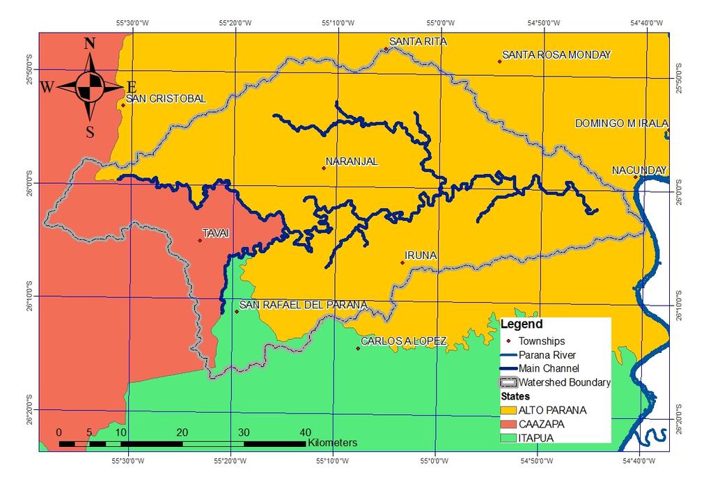
5 Study Area: NACUNDAY BASIN Area: 2430 km2 Elevation: msl (ranging flat to gently slope) Climate: Humid subtropical climate (Cfa)
6 SPATIAL DATA ARC SWAT INPUT DATA TREE CORE NON-SPATIAL DATA OPTIONAL DATA DEM LAND USE MAP SOIL MAP WEATHER STATIONS LOCATIONS POINT SOURCES WATER QUALITY HYDRO- GEOLOGY WATER USES SOILS CLIMATE MANAGEMENT PRACTICE Chemical data: Soil NO3, Soil Org N, Soil P, Soil Org. Physical data: Ksat, Bulk density, Texture, AWC, USLE K, Org C, Rock fragm., Soil Hydrologic Group Weather: Max Temp., Min Temp., Solar radiation, Wind speed, Relative Humid. Precipitation: Rainfall, Snow Planting date, Harvest date, crop rotation, Fertilizer, Pesticide, Irrigation, Tillage Information
 90-m resolution Geographic coordinate system: GCS_WGS_1984, Projected to:")
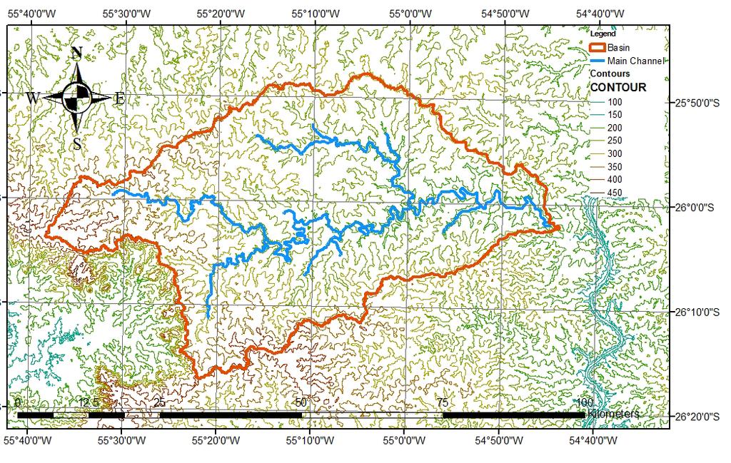
7 DEM Digital Elevation Map Global SRTM data ( 8080/esdi/index.jsp) 90-m resolution Geographic coordinate system: GCS_WGS_1984, Projected to: WGS_1984_UTM_ZONE_21S


8 LAND USE MAP and 2009 Landsat-5 Thematic Mapper images 30-m spatial resolution Geographic coordinate system: GCS_South_American_1969. Reclassification Projected to : WGS_1984_UTM_ZONE_21S 2009
 Geographic coordinate system: GCS_South_American_1969 Projected to the")
9 FAO-UNESCO Soil Map of the World (DSMW) downloaded from the World Soil Information (ISRIC) website ( The spatial data s resolution is 5 by 5 arc-minutes grid (Batjes, 2006) Geographic coordinate system: GCS_South_American_1969 Projected to the WGS_1984_UTM_ZONE_21S SOIL MAP
 NAME XPR YPR LAT LONG BARRA 700 560.44 7 122 162.")
10 WEATHER STATIONS LOCATIONS Daily Rainfall, Temperature, Relative Humidity From to Barra Station given by the National Agency of Electricity (ANDE) NAME XPR YPR LAT LONG BARRA S W
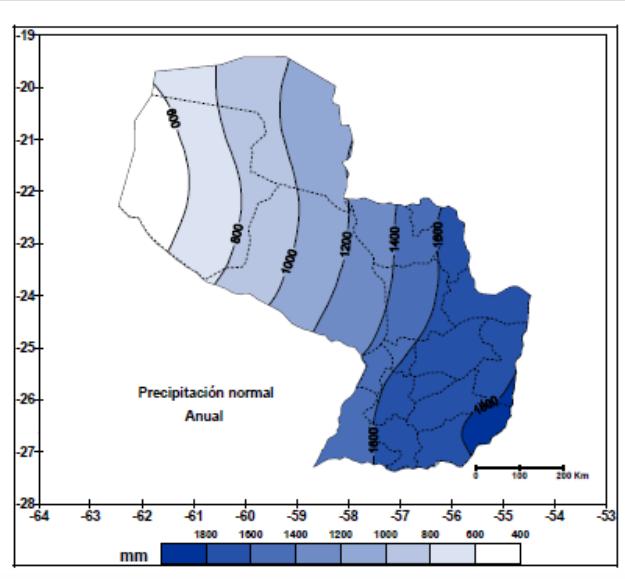
11 CLIMATE Meteorology data provided by ANDE Daily data for: Rainfall (mm) Temperature (Maximum, Minimum) ( C) Relative Humidity(%) From Jan 1, 1999 to Sept 30, Wind speed and Solar Radiation generated by weather generator. Pcp.dbf Tempe.dbf Rh.dbf Formulas Data
12 SOIL FAO-UNESCO Soil Map ( Two types of soils units were identify in the study area Units are 5614 and 5717 Several physical and chemical parameters of soil layers. OBJECTID MUID SEQN SNAM S5ID CMPPCT NLAYERS HYDGRP SOL_ZMX ANION_EXCL SOL_CRK TEXTURE FAO C CL FAO B FSL-FC SOL_Z1 SOL_BD1 SOL_AWC1 SOL_K1 SOL_CBN1 CLAY1 SILT1 SAND1 ROCK1 SOL_ALB1 USLE_K1 SOL_EC SOL_Z2 SOL_BD2 SOL_AWC2 SOL_K2 SOL_CBN2 CLAY2 SILT2 SAND2 ROCK2 SOL_ALB2 USLE_K2 SOL_EC SOL_Z3 SOL_BD3 SOL_AWC3 SOL_K3 SOL_CBN3 CLAY3 SILT3 SAND3 ROCK3 SOL_ALB3 USLE_K3 SOL_EC SOL_Z4 SOL_BD4 SOL_AWC4 SOL_K4 SOL_CBN4 CLAY4 SILT4 SAND4 ROCK4 SOL_ALB4 USLE_K4 SOL_EC SOL_Z5 SOL_BD5 SOL_AWC5 SOL_K5 SOL_CBN5 CLAY5 SILT5 SAND5 ROCK5 SOL_ALB5 USLE_K5 SOL_EC DEFINITIONS
13 RS IMAGE Image Classification METHODOLOGY GIS DATA LAYERS Formatting into ARC SWAT Land Use map Soil map DEM Overlay for HRU definition Other optional data (Water quality, groundwater, fertilizer, pesticide, plant growth, crop timing & rotation ARC SWAT INTERFACE SWAT RUN VALIDATION Sub watershed delineation Catchment specific databases (soil parameters, weather data) CALIBRATION Changing one at the time parameters SENSITIVITY

14 Nacunday Watershed delineation

15 HRU s definition THRESHOLD=20% THRESHOLD= 5% Over Soil Sub Area Basin Area 83 HRU S THRESHOLD=20% Over Land Use Area
16 For any process studied with SWAT, water balance is the driving force behind what is SW t is the final soil water content (mm H 2 O); SW 0 is the initial soil water content(mm H happening in the 2 O); watershed. t is the time for the simulation period(days); R i precipitation, Q i runoff, Et i evapo-transpiration P i Percolation QR i return flow, on day i(mm H 2 O).

17 Parameters involved in stream flow modeling. PRECIPITATION SURLAG EPCO ESCO CN ALPHA_BF GW_DELAY REVAPMN GW_REVAP CH_N2 CH_K2
18 RELATIVE ORDER OF SENSITIVITY OF PARAMETERS GOVERNING RUNOFF RESPONSE Range Sensitivity Order Parameter code* Lower Upper Sub basin data 1 Alpha_Bf 0 1 *.gw 2 Surlag 0 10 *.bsn 3 Ch_N2 0 1 *.rte 4 Ch_K *.rte 5 Cn *.mgt INITIAL SENSITIVITY 6 Esco 0 1 *.hru,*.bsn 7 Gwqmn *.gw ANALYSIS 8 Sol_Z *.sol 9 Gw_Delay *.gw 10 Sol_Awc *.sol 11 Canmx 0 10 *.hru 12 Blai 0 1 *crop.dat 13 Gw_Revap *.gw 14 Sol_K *.sol 15 Epco 0 1 *.hru,*.bsn 16 Revapmn *.gw 17 Sol_Alb *.sol 18 Slope *.hru 19 Biomix 0 1 *.mgt
19 Monthly runoff Calibration Period CALIBRATION Runoff (mm) GRAPHICAL TECHNIQUE /01 3/01 5/01 7/01 9/01 11/01 1/02 3/02 5/02 7/02 9/02 11/02 1/03 3/03 5/03 7/03 9/03 11/03 1/04 3/04 5/04 7/04 9/04 11/04 1/05 3/05 5/05 7/05 9/05 11/05 Calibration Months (mm/yy) Measured Simulated
20 Daily Runoff Calibration Period SURLAG SOL_K; SOL_AWC; SOL_ALB; 12 CN2 CH_N2 Runoff (mm) 10 8 EPCO ALPHA_BF /1/01 3/1/01 5/1/01 7/1/01 9/1/01 11/1/01 1/1/02 3/1/02 5/1/02 7/1/02 9/1/02 11/1/02 1/1/03 3/1/03 5/1/03 7/1/03 9/1/03 11/1/03 1/1/04 3/1/04 5/1/04 7/1/04 9/1/04 11/1/04 1/1/05 3/1/05 5/1/05 7/1/05 9/1/05 11/1/05 1/1/06 CH_K2 ESCO REVAPMN GW_DELAY GW_REVAP GWQMN Date (dd/mm/yy) Simulated Measured
21 STATISTICAL TECHNIQUE Coefficient of Determination (R 2 ): Nash-Sutcliffe efficiency (NSE): Percent bias (PBIAS):
22 PREFORMANCE RATING Coefficient of Determination (R 2 ): Nash-Sutcliffe Greater than 0.5 efficiency are considered (NSE): Percent bias (PBIAS): acceptable Model (Santhi Value et al., Performance 2001, Van Rating Model Value Performance Liew et al., 2003). Rating SWAT >0.65 Very Good SWAT <10% Very Good SWAT 0.54 to 0.65 Adequate SWAT <10% to <15% Good SWAT >0.5 Satisfactory SWAT <15% to <25% Satisfactory SWAT >25% Unsatisfactory (Moriasi et al.2007).
23 CALIBRATED VALUES OF PARAMETERS Parameters Code* Unit Initial Value Calibrated Value ALPHA_BF days CH_K2 mm/hr CH_N2 n/a CN2 n/a 73,60,85,78 42,65,61 EPCO Fraction ESCO Fraction GW_DELAY days GW_REVAP n/a GWQMN mm REVAPMN mm 1 50 SOL_ALB top layer SOL_Z mm SURLAG days SOL_AWC (mmh2o/mm) 0.05,0.04,0.04,0.05, ,0.2,0.2,0.21,0.25 SOL_AWC (mmh2o/mm) 0.1,0.1,0.1,0.11, ,0.15,0.15,0.17,0.20 SOL_K (mm/hr) 1.5,1,1,0.9, ,4.21,2.34,1.17,0.7 SOL_K (mm/hr) 3.4,1.5,1.3,1.2, ,23.36,17.52,11.68,4.67
24 NSE AND R 2 INDEXES VALUES FOR MODEL EVALUATION IN MONTHLY AND DAILY BASIS. Daily Monthly NSE R2 NSE R2 Calibration Period Validation Period
25 YEARLY PBIAS Year DISCHARGE (mm) SIMULATED (mm) BIAS
26 Monthly runoff Validation Period NSE = 0.61 R2 = 0.67 Runoff (mm) VALIDATION 0.00 Validation Months (mm/yy) Measured Simulated
27 Daily Runoff Validation Period NSE = 0.55 R2 = Runoff (mm) Date (dd/mm/yy) Simulated Measured
28 CONCLUSIONS 1. During the calibration Monthly Daily NSE R2 R2 PBIAS Calibration varied between ±16% which could be performance Satisfactory of the model Calibration considered Period Period as good overall annual performance simulation of the model Very good
29 CONCLUSIONS 2. During the Validation Monthly Daily The PBIAS remained within ±16.5% except for year 2006 where the annual PBIAS of 33.4% NSE NSE was obtained R2 R2 indicating under Satisfactory simulation of performance of the model discharge Validation from Period model Therefore on the basis of PBIAS the model performance Validation can Period be rated as good except for year

30 CONCLUSIONS The results obtained from model are rated acceptable Despite the limitations of: Using large spatial resolution soil data Use of single rain gauge for representing catchment averaged rainfall. The model captured rather well the dynamic of flow generation, with surface runoff uniformly distributed along the year and shallow aquifer contribution during winter s months of July and August.
31 CONCLUSIONS The simulated discharge from SWAT model, both for daily and monthly basis in Nacunday watershed can be rated within acceptable range of errors, so future use of the SWAT model for various scenario testing is reasonable.
32 RECOMMENDATION FOR FURTHER STUDIES Further studies may be undertaken to incorporate field-measured parameters and better representation of soil and rainfall distribution information into the model. Using more field measurements and fewer default values for inputs may provide better opportunity to improve further the SWAT Model s representation of processes in the Nacunday River Basin.
33 THANK YOU
Evaluation of the SWAT Model Setup Process Through A Case Study in Roxo Catchment, Portugal
 Evaluation of the SWAT Model Setup Process Through A Case Study in Roxo Catchment, Portugal Mustafa Gökmen Master Degree in on Geo-information and Earth Observation for Integrated Catchment and Water Resources
Under the guidance of Prof.C S P Ojha
 A Presentation by KAUSHIKA G S Under the guidance of Prof.C S P Ojha HYDRAULICS ENGINEERING GROUP DEPARTMENT OF CIVIL ENGINEERING INDIAN INSTITUTE OF TECHNOLOGY ROORKEE ROORKEE 247 667, Uttarakhand, INDIA
Comparison of Flow Calibration Using NEXRAD and Surface Rain Gauge Data in ArcSWAT
 Comparison of Flow Calibration Using NEXRAD and Surface Rain Gauge Data in ArcSWAT Presenter: Aisha M. Sexton USDA-ARS-HRSL / UMD Coauthors: Ali Sadeghi, Raghavan Srinivasan, Adel Shirmohammadi, and Xuesong
Modeling of a River Basin Using SWAT Model and SUFI-2
 Modeling of a River Basin Using SWAT Model and SUFI-2 NINA OMANI MASOUD TAJRISHY AHMAD ABRISHAMCHI Sharif University of Technology, Tehran, Iran Karkheh Dam, Iran 1 Area of Gharasu Sub-basin : 5793 km2
Setting up SWAT for the Upper Amazon
 2014 International SWAT Conference Setting up SWAT for the Upper Amazon Michael Strauch, Martin Volk 2014 International SWAT Conference Porto de Galinhas, July 30 August 1, 2014 ISI-MIP2 Inter-Sectoral
MODELING RUNOFF RESPONSE TO CHANGING LAND COVER IN PENGANGA SUBWATERSHED, MAHARASHTRA
 MODELING RUNOFF RESPONSE TO CHANGING LAND COVER IN PENGANGA SUBWATERSHED, MAHARASHTRA Abira Dutta Roy*, S.Sreekesh** *Research Scholar, **Associate Professor Centre for the Study of Regional Development,
Hydrologic Modelling of the Upper Malaprabha Catchment using ArcView SWAT
 Hydrologic Modelling of the Upper Malaprabha Catchment using ArcView SWAT Technical briefs are short summaries of the models used in the project aimed at nontechnical readers. The aim of the PES India
Modelling Runoff with Satellite Data. Nyandwaro Gilbert Nyageikaro Patrick Willems Joel Kibiiy
 Modelling Runoff with Satellite Data Nyandwaro Gilbert Nyageikaro Patrick Willems Joel Kibiiy 1 Outline Background information SWAT model development The model sensitivity analysis and calibration Calibration
MODULE 8 LECTURE NOTES 2 REMOTE SENSING APPLICATIONS IN RAINFALL-RUNOFF MODELLING
 MODULE 8 LECTURE NOTES 2 REMOTE SENSING APPLICATIONS IN RAINFALL-RUNOFF MODELLING 1. Introduction The most common application of the remote sensing techniques in the rainfall-runoff studies is the estimation
Jorge Enoch Furquim Werneck Lima. Euzebio Medrado da Silva. Michael Strauch. Carsten Lorz. Hochschule Weihenstephan- Triesdorf
 Jorge Enoch Furquim Werneck Lima Euzebio Medrado da Silva Michael Strauch Carsten Lorz Hochschule Weihenstephan- Triesdorf SWAT is a physically-based hydrological model spatially distributed parameters
Integration of TUSLE in SWAT model for sediment prediction at a small mountainous catchment,chenyulan watershed,taiwan
 Integration of TUSLE in SWAT model for sediment prediction at a small mountainous catchment,chenyulan watershed,taiwan Presenter : Chih-Mei Lu Authors : Chih-Mei Lu, Li-Chi Chiang * Department of Civil
Two-Step Calibration Method for SWAT
 SWAT 2005 Zurich, Switzerland July 14 th, 2005 Two-Step Calibration Method for SWAT Francisco Olivera, Ph.D. Assistant Professor Huidae Cho Graduate Student Department of Civil Engineering Texas A&M University
Analyzing spatial and temporal variation of water balance components in La Vi catchment, Binh Dinh province, Vietnam
 Analyzing spatial and temporal variation of water balance components in La Vi catchment, Binh Dinh province, Vietnam Nguyen Duy Liem, Vo Ngoc Quynh Tram, Nguyen Le Tan Dat, Nguyen Kim Loi Nong Lam University-
Uncertainty in the SWAT Model Simulations due to Different Spatial Resolution of Gridded Precipitation Data
 Uncertainty in the SWAT Model Simulations due to Different Spatial Resolution of Gridded Precipitation Data Vamsi Krishna Vema 1, Jobin Thomas 2, Jayaprathiga Mahalingam 1, P. Athira 4, Cicily Kurian 1,
Liliana Pagliero June, 15 th 2011
 Liliana Pagliero liliana.pagliero@jrc.ec.europa.eu June, 15 th 2011 2/18 SWAT MODELLING AT PAN EUROPEAN SCALE: THE DANUBE BASIN PILOT STUDY Introduction The Danube Model Available databases Model set up
July, International SWAT Conference & Workshops
 July, 212 212 International SWAT Conference & Workshops Hydrological Modelling of Kosi and Gandak Basins using SWAT Model S. Dutta, Pritam Biswas, Sangita Devi, Suresh A Karth and Bimlesh kumar, Ganga
Effects of elevation bands and snow parameters on the hydrological modeling of the upper part of the Garonne watershed (France)
") Effects of elevation bands and snow parameters on the hydrological modeling of the upper part of the Garonne watershed (France) SUN, X., HONG, Y., BERNARD-JANNIN, L., CHEA, R., SAUVAGE, S., SANCHEZ-PEREZ,
Effects of elevation bands and snow parameters on the hydrological modeling of the upper part of the Garonne watershed (France) SUN, X., HONG, Y., BERNARD-JANNIN, L., CHEA, R., SAUVAGE, S., SANCHEZ-PEREZ,
Simulation of sedimentation rates using the SWAT model A case study of the Tarbela Dam, Upper Indus Basin
 Simulation of sedimentation rates using the SWAT model A case study of the Tarbela Dam, Upper Indus Basin Ahammad, H. I 1., Crosato A 2,3., Maskey, S 2., Masih, I 2,*, McClain, M 2. 1 Punjab Irrigation
Effect of GIS data quality on small watershed stream flow and sediment simulations
 HYDROLOGICAL PROCESSES Hydrol. Process. 19, 629 650 (2005) Published online in Wiley InterScience (www.interscience.wiley.com). DOI: 10.1002/hyp.5612 Effect of GIS data quality on small watershed stream
Assessment of solid load and siltation potential of dams reservoirs in the High Atlas of Marrakech (Moorcco) using SWAT Model
 using SWAT Model") Assessment of solid load and siltation potential of dams reservoirs in the High Atlas of Marrakech (Moorcco) using SWAT Model Amal Markhi: Phd Student Supervisor: Pr :N.Laftrouhi Contextualization Facing
Assessment of solid load and siltation potential of dams reservoirs in the High Atlas of Marrakech (Moorcco) using SWAT Model Amal Markhi: Phd Student Supervisor: Pr :N.Laftrouhi Contextualization Facing
Challenges in Calibrating a Large Watershed Model with Varying Hydrogeologic Conditions
 Challenges in Calibrating a Large Watershed Model with Varying Hydrogeologic Conditions Presented by Johnathan R. Bumgarner, P.G., Celine A.L. Louwers, & Monica P. Suarez, P.E. In cooperation with the
GIS BASED HYDROLOGICAL MODELLING FOR CLIMATE CHANGE IMPACT ASSESSMENT. Dr. Amardeep Singh, MoWR Prof. A. K. Gosain, IIT Delhi
 GIS BASED HYDROLOGICAL MODELLING FOR CLIMATE CHANGE IMPACT ASSESSMENT Dr. Amardeep Singh, MoWR Prof. A. K. Gosain, IIT Delhi Model Description SWAT (Soil and Water Assessment Tool) Conceptual, distributed,
Conservation Planning evaluate land management alternatives to reduce soil erosion to acceptable levels. Resource Inventories estimate current and
 Conservation Planning evaluate land management alternatives to reduce soil erosion to acceptable levels. Resource Inventories estimate current and projected erosion levels and their impact on natural resource
Erosion modelling in the upper Blue Nile basin: The case of Mizewa watershed in Ethiopia
 Erosion modelling in the upper Blue Nile basin: The case of Mizewa watershed in Ethiopia Citation: Assegahegn, M.A. and Zemadim, B. Erosion modelling in the upper Blue Nile basin: The case of Mizewa watershed
CHAPTER VII FULLY DISTRIBUTED RAINFALL-RUNOFF MODEL USING GIS
 80 CHAPTER VII FULLY DISTRIBUTED RAINFALL-RUNOFF MODEL USING GIS 7.1GENERAL This chapter is discussed in six parts. Introduction to Runoff estimation using fully Distributed model is discussed in first
Flood Forecasting Tools for Ungauged Streams in Alberta: Status and Lessons from the Flood of 2013
 Flood Forecasting Tools for Ungauged Streams in Alberta: Status and Lessons from the Flood of 2013 John Pomeroy, Xing Fang, Kevin Shook, Tom Brown Centre for Hydrology, University of Saskatchewan, Saskatoon
Climate Change Impact Assessment on Long Term Water Budget for Maitland Catchment in Southern Ontario
 215 SWAT CONFERENCE, PURDUE Climate Change Impact Assessment on Long Term Water Budget for Maitland Catchment in Southern Ontario By Vinod Chilkoti Aakash Bagchi Tirupati Bolisetti Ram Balachandar Contents
Danielle A. Bressiani 1, *, R. Srinivasan 2, E. M. Mendiondo 1,3 & K. C. Abbaspour 4
 2015 International SWAT Conference Pula, Sardinia, Italy Danielle A. Bressiani 1, *, R. Srinivasan 2, E. M. Mendiondo 1,3 & K. C. Abbaspour 4 1 Engineering School of São Carlos, University of São Paulo
Building a European-wide hydrological model
 Building a European-wide hydrological model 2010 International SWAT Conference, Seoul - South Korea Christine Kuendig Eawag: Swiss Federal Institute of Aquatic Science and Technology Contribution to GENESIS
Appendix D. Model Setup, Calibration, and Validation
 . Model Setup, Calibration, and Validation Lower Grand River Watershed TMDL January 1 1. Model Selection and Setup The Loading Simulation Program in C++ (LSPC) was selected to address the modeling needs
Using MODIS imagery to validate the spatial representation of snow cover extent obtained from SWAT in a data-scarce Chilean Andean watershed
 Using MODIS imagery to validate the spatial representation of snow cover extent obtained from SWAT in a data-scarce Chilean Andean watershed Alejandra Stehr 1, Oscar Link 2, Mauricio Aguayo 1 1 Centro
Climatic Change Implications for Hydrologic Systems in the Sierra Nevada
 Climatic Change Implications for Hydrologic Systems in the Sierra Nevada Part Two: The HSPF Model: Basis For Watershed Yield Calculator Part two presents an an overview of why the hydrologic yield calculator
Streamflow, Sediment, and Nutrient Simulation of the Bitterroot Watershed using SWAT
 Streamflow, Sediment, and Nutrient Simulation of the Bitterroot Watershed using SWAT by Dr. Michael Van Liew Montana Department of Environmental Quality Helena, Montana, USA Site Map of SWAT Watersheds
The Importance of Snowmelt Runoff Modeling for Sustainable Development and Disaster Prevention
 The Importance of Snowmelt Runoff Modeling for Sustainable Development and Disaster Prevention Muzafar Malikov Space Research Centre Academy of Sciences Republic of Uzbekistan Water H 2 O Gas - Water Vapor
GLACIER AND SNOWMELT MODELLING USING SWAT: GANGA BASIN CASE STUDY. INRM Consultants Pvt. Ltd.
 GLACIER AND SNOWMELT MODELLING USING SWAT: GANGA BASIN CASE STUDY INRM Consultants Pvt. Ltd. Introduction Snowmelt Runoff contribution in the Himalayan Rivers Estimation of Average contribution of Snowmelt
Application of SWAT for the modelling of sediment yield at Pong reservoir, India
 Application of SWAT for the modelling of sediment yield at Pong reservoir, India A. R. Senthil kumar Tanmoyee Bhattacharya Suhas D Khobragade Manohar Arora National Institute of Hydrology Roorkee-247667,
IMPACT OF CLIMATE CHANGE OVER THE ARABIAN PENINSULA
 IMPACT OF CLIMATE CHANGE OVER THE ARABIAN PENINSULA By: Talal Alharbi June, 29 2017 1 Motivation: In arid and semi-arid regions of the world the demand for fresh water resources is increasing due to: increasing
Evaluation of small watersheds inflowing Lake Shinji against the water environment
 SHIMANE University International SWAT Conference in Paul Sabatier University 17-19 July 213 Evaluation of small watersheds inflowing Lake Shinji against the water environment Shimane University Hiroaki
Hands On Applications of the Latin American and Caribbean Flood and Drought Monitor (LACFDM)
") Hands On Applications of the Latin American and Caribbean Flood and Drought Monitor (LACFDM) Colby Fisher, Eric F Wood, Justin Sheffield, Nate Chaney Princeton University International Training: Application
Hands On Applications of the Latin American and Caribbean Flood and Drought Monitor (LACFDM) Colby Fisher, Eric F Wood, Justin Sheffield, Nate Chaney Princeton University International Training: Application
12 SWAT USER S MANUAL, VERSION 98.1
 12 SWAT USER S MANUAL, VERSION 98.1 CANOPY STORAGE. Canopy storage is the water intercepted by vegetative surfaces (the canopy) where it is held and made available for evaporation. When using the curve
Setting up SWAT to quantify water-related ecosystem services in a large East African watershed
 Benedikt Notter, University of Bern, Switzerland Setting up SWAT to quantify water-related ecosystem services in a large East African watershed 5th International SWAT Conference August 5 7, Boulder, Colorado
Impact of different types of meteorological data inputs on predicted hydrological and erosive responses to projected land use change
 Impact of different types of meteorological data inputs on predicted hydrological and erosive responses to projected land use change Suman Bhattacharyya 1 & Joy Sanyal * 1 2 1 Department of Geography,
Development of the Hydrologic Model
 Kick-off meeting on enhancing hydrological data management and exchange procedures Water and Climate Adaptation Plan (WATCAP) for Sava River Basin Development of the Hydrologic Model David Heywood Team
SWAT 2015 International Conference:
 SWAT 2015 International Conference: Comparative Analysis of Spatial Resolution Effects on Standard and Grid-based SWAT Models Presented by: Garett Pignotti Co-authors: Dr. Hendrik Rathjens, Dr. Cibin Raj,
Application of SWAT Model for Mountainous Catchment
 LARS 2007 Catchment and Lake Research Application of SWAT Model for Mountainous Catchment Birhanu, B.Z, Ndomba, P.M and Mtalo, F.W. University of Dar es Salaam, Water Resources Engineering Abstract A GIS
Changing Hydrology under a Changing Climate for a Coastal Plain Watershed
 Changing Hydrology under a Changing Climate for a Coastal Plain Watershed David Bosch USDA-ARS, Tifton, GA Jeff Arnold ARS Temple, TX and Peter Allen Baylor University, TX SEWRU Objectives 1. Project changes
Near Real-Time Runoff Estimation Using Spatially Distributed Radar Rainfall Data. Jennifer Hadley 22 April 2003
 Near Real-Time Runoff Estimation Using Spatially Distributed Radar Rainfall Data Jennifer Hadley 22 April 2003 Introduction Water availability has become a major issue in Texas in the last several years,
Dr. S.SURIYA. Assistant professor. Department of Civil Engineering. B. S. Abdur Rahman University. Chennai
 Hydrograph simulation for a rural watershed using SCS curve number and Geographic Information System Dr. S.SURIYA Assistant professor Department of Civil Engineering B. S. Abdur Rahman University Chennai
ESTIMATION OF DISCHARGE FOR UNGAUGED CATCHMENTS USING RAINFALL-RUNOFF MODEL IN DIDESSA SUB-BASIN: THE CASE OF BLUE NILE RIVER BASIN, ETHIOPIA.
 ESTIMATION OF DISCHARGE FOR UNGAUGED CATCHMENTS USING RAINFALL-RUNOFF MODEL IN DIDESSA SUB-BASIN: THE CASE OF BLUE NILE RIVER BASIN, ETHIOPIA. CHEKOLE TAMALEW Department of water resources and irrigation
Application of SWAT Model to Estimate the Runoff and Sediment Load from the Right Bank Valleys of Mosul Dam Reservoir
 Application of SWAT Model to Estimate the Runoff and Sediment Load from the Right Bank Valleys of Mosul Dam Reservoir Dr Mohammad Ezeel Deen Prof. Nadhir Al-Ansari Prof Sven Knutsson Figure 1.Map of Iraq
Journal of Natural & Environmental Sciences
 Journal of Natural & Environmental Sciences www.academyjournals.net Original Article High Spatial Resolution Soil Data for Watershed Modeling: 1. Development of a SSURGO- ArcSWAT Utility Aleksey Y. SHESHUKOV
International Journal of Scientific & Engineering Research, Volume 6, Issue 8, August ISSN
 International Journal of Scientific & Engineering Research, Volume 6, Issue 8, August-2015 1670 DEM Processing for Watershed Delineation using QSWAT M.V.S.S. Giridhar 1, Ramaraju Anirudh 2, G. Sreenivasa
Overview of Data for CREST Model
 Overview of Data for CREST Model Xianwu Xue April 2 nd 2012 CREST V2.0 CREST V2.0 Real-Time Mode Forcasting Mode Data Assimilation Precipitation PET DEM, FDR, FAC, Slope Observed Discharge a-priori parameter
Lake Tahoe Watershed Model. Lessons Learned through the Model Development Process
 Lake Tahoe Watershed Model Lessons Learned through the Model Development Process Presentation Outline Discussion of Project Objectives Model Configuration/Special Considerations Data and Research Integration
Soil Erosion Calculation using Remote Sensing and GIS in Río Grande de Arecibo Watershed, Puerto Rico
 Soil Erosion Calculation using Remote Sensing and GIS in Río Grande de Arecibo Watershed, Puerto Rico Alejandra M. Rojas González Department of Civil Engineering University of Puerto Rico at Mayaguez.
Hydrological modelling of the Lena River using SWIM
 Hydrological modelling of the Lena River using SWIM Michel Wortmann 1 1 Potsdam Institute for Climate Impact Research (PIK), Germany July 8, 214 Contents 1 The Lena catchment and data used 1 1.1 Discharge
Technical Memorandum FINAL
 Technical Memorandum FINAL To: Project File A previous effort to develop and calibrate a Soil and Water Assessment Tool (SWAT) watershed model for the Cedar River basin included a limited representation
DEVELOPMENT AND APPLICATION OF A HYDROCLIMATOLOGICAL STREAM TEMPERATURE MODEL WITHIN SWAT
 DEVELOPMENT AND APPLICATION OF A HYDROCLIMATOLOGICAL STREAM TEMPERATURE MODEL WITHIN SWAT Darren L. Ficklin 1, Yuzhou Luo 2, Iris T. Stewart 1, Edwin P. Maurer 3 1 Environmental Studies Institute, Santa
VIC Hydrology Model Training Workshop Part II: Building a model
 VIC Hydrology Model Training Workshop Part II: Building a model 11-12 Oct 2011 Centro de Cambio Global Pontificia Universidad Católica de Chile Ed Maurer Civil Engineering Department Santa Clara University
Gökhan Cüceloğlu, İzzet Öztürk. Istanbul Technical University Department of Environmental Engineering Maslak/IstanbulTurkey
 Assessing the Influence of Climate Datasets for Quantification of Water Balance Components in Black Sea Catchment: Case Study for Melen Watershed, Turkey Gökhan Cüceloğlu, İzzet Öztürk Istanbul Technical
Study of Hydrometeorology in a Hard Rock Terrain, Kadirischist Belt Area, Anantapur District, Andhra Pradesh
 Open Journal of Geology, 2012, 2, 294-300 http://dx.doi.org/10.4236/ojg.2012.24028 Published Online October 2012 (http://www.scirp.org/journal/ojg) Study of Hydrometeorology in a Hard Rock Terrain, Kadirischist
Hydrologic Response of SWAT to Single Site and Multi- Site Daily Rainfall Generation Models
 Hydrologic Response of SWAT to Single Site and Multi- Site Daily Rainfall Generation Models 1 Watson, B.M., 2 R. Srikanthan, 1 S. Selvalingam, and 1 M. Ghafouri 1 School of Engineering and Technology,
Improved ensemble representation of soil moisture in SWAT for data assimilation applications
 Improved ensemble representation of soil moisture in SWAT for data assimilation applications Amol Patil and RAAJ Ramsankaran Hydro-Remote Sensing Applications (H-RSA) Group, Department of Civil Engineering
Introduction. Agronomy New Zealand 48, NZ-NSD use in SWAT
 Deriving a dataset from the New Zealand National Soils Database (NZ-NSD) for use in Soil and Water Assessment Tool (SWAT) Modelling A. Parshotam Aqualinc Research Ltd aroon@aqualinc.co.nz Abstract Pre-processed
Effects of Physical Catchment Characteristics on River Flow
 Effects of Physical Catchment Characteristics on River Flow A Tale of Two Tributaries Abeyou W. Worqlul, Essayas K. Ayana, Fasikaw Atanaw, Amy S. Collick, Charlotte McAlister, Robin Taylor & Tammo S. Steenhuis
Coupling a basin erosion and river sediment transport model into a large scale hydrological model
 Hydrology and Geodynamics of the basins of South America 4 th scientific meeting of ORE HYBAM www.ore-hybam.org Lima, 6-9 September 2011 Coupling a basin erosion and river sediment transport model into
Hydrological modeling and flood simulation of the Fuji River basin in Japan
 Hydrological modeling and flood simulation of the Fuji River basin in Japan H. A. P. Hapuarachchi *, A. S. Kiem, K. Takeuchi, H. Ishidaira, J. Magome and A. Tianqi T 400-8511, Takeuchi-Ishidaira Lab, Department
Delineation of Groundwater Potential Zone on Brantas Groundwater Basin
 Delineation of Groundwater Potential Zone on Brantas Groundwater Basin Andi Rachman Putra 1, Ali Masduqi 2 1,2 Departement of Environmental Engineering, Sepuluh Nopember Institute of Technology, Indonesia
ESTIMATING SNOWMELT CONTRIBUTION FROM THE GANGOTRI GLACIER CATCHMENT INTO THE BHAGIRATHI RIVER, INDIA ABSTRACT INTRODUCTION
 ESTIMATING SNOWMELT CONTRIBUTION FROM THE GANGOTRI GLACIER CATCHMENT INTO THE BHAGIRATHI RIVER, INDIA Rodney M. Chai 1, Leigh A. Stearns 2, C. J. van der Veen 1 ABSTRACT The Bhagirathi River emerges from
Eric. W. Harmsen 1, John Mecikalski 2, Pedro Tosado Cruz 1 Ariel Mercado Vargas 1
 Estimating Evapotranspiration using Satellite Remote Sensing in Puerto Rico, Haiti and the Dominican Republic Eric. W. Harmsen 1, John Mecikalski 2, Pedro Tosado Cruz 1 Ariel Mercado Vargas 1 1. University
Application of the SWAT hydrological model in a small, mountainous catchment in South Africa
 Application of the SWAT hydrological model in a small, mountainous catchment in South Africa by Kimberley Anne Perry Submitted in partial fulfilment of the requirements for the degree MASTER OF SCIENCE
Effect of land use/land cover changes on runoff in a river basin: a case study
 Water Resources Management VI 139 Effect of land use/land cover changes on runoff in a river basin: a case study J. Letha, B. Thulasidharan Nair & B. Amruth Chand College of Engineering, Trivandrum, Kerala,
Uncertainty analysis of nonpoint source pollution modeling:
 2013 SWAT Conference Uncertainty analysis of nonpoint source pollution modeling: An important implication for Soil and Water Assessment Tool Professor Zhenyao Shen 2013-07-17 Toulouse Contents 1 2 3 4
HYDROLOGICAL MODELLING OF COOUM RIVER BASIN USING GIS AND SWAT MODEL
 HYDROLOGICAL MODELLING OF COOUM RIVER BASIN USING GIS AND SWAT MODEL Sravani Duvvuri Assistant Professor in Civil Engineering Rajiv Gandhi University of Knowledge Technologies, IIIT Nuzvid, Quarter No:
Assessing the Hydrologic Implications of Land Use Change for the Upper Neuse River Basin. Kelly Conaghan Dr. Dean Urban, Advisor May 2010
 Assessing the Hydrologic Implications of Land Use Change for the Upper Neuse River Basin By Kelly Conaghan Dr. Dean Urban, Advisor May 2010 Masters project submitted in partial fulfillment of the requirements
SEDIMENT INFLOW ESTIMATION AND MAPPING ITS SPATIAL DISTRIBUTION AT SUB-BASIN SCALE: THE CASE OF TENDAHO DAM, AFAR REGIONAL STATE, ETHIOPIA
 Ethiopian Journal of Environmental Studies & Management 10(3): 315 339, 2017. ISSN:1998-0507 doi: https://dx.doi.org/10.4314/ejesm.v10i3.4 Submitted: December 10, 2016 Accepted: April 08, 2017 SEDIMENT
Introduction to the new modular SWAT code: The input file structure explained using the example of the Little River Experimental Watershed, USA
 Introduction to the new modular SWAT code: The input file structure explained using the example of the Little River Experimental Watershed, USA Katrin Bieger and Jeffrey G. Arnold 2014 International SWAT
SWAT WEATHER DATABASE TOOL
 A SUPPORT SYSTEM FOR THE LONG-TERM ANALYSIS OF CLIMATE SCENARIOS WITH SWAT Arthur H. Essenfelder Centro Euro-Mediterraneo sui Cambiamenti Climatici CMCC 2017 INTERNATIONAL SWAT CONFERENCE 28 30 JUNE 2017,
Current and Future Plans. R. Srinivasan
 Current and Future Plans R. Srinivasan Contents 1 The ArcSWAT Interface 2 VizSWAT: Output Visualization 3 User online support 4 MapWindows SWAT interface 5 ArcGIS SWAT/APEX interfaces 6 Radar Rainfall
Spatial Distributions and Stochastic Parameter Influences on SWAT Flow and Sediment Predictions
 Spatial Distributions and Stochastic Parameter Influences on SWAT Flow and Sediment Predictions Kati W. Migliaccio 1 and Indrajeet Chaubey 2 Abstract: The Soil and Water Assessment Tool SWAT was implemented
CIMIS. California Irrigation Management Information System
 CIMIS California Irrigation Management Information System What is CIMIS? A network of over 130 fully automated weather stations that collect weather data throughout California and provide estimates of
BSYSE 456/556 Surface Hydrologic Processes and Modeling
 BSYSE 456/556 Surface Hydrologic Processes and Modeling Lab 9 (Prepared by Erin Brooks and Jan Boll, UI, and Joan Wu, WSU) P Introduction One of the most difficult tasks in watershed assessment and management
INTERNATIONAL JOURNAL OF PURE AND APPLIED RESEARCH IN ENGINEERING AND TECHNOLOGY
 INTERNATIONAL JOURNAL OF PURE AND APPLIED RESEARCH IN ENGINEERING AND TECHNOLOGY A PATH FOR HORIZING YOUR INNOVATIVE WORK SPECIAL ISSUE FOR NATIONAL LEVEL CONFERENCE "SUSTAINABLE TECHNOLOGIES IN CIVIL
Application of Soil and Water Assessment Tool (SWAT) Model to Predict Streamflow and Sediment Yield in Wahig-Inabanga Watershed, Bohol, Philippines
 Model to Predict Streamflow and Sediment Yield in Wahig-Inabanga Watershed, Bohol, Philippines") Research article erd Application of Soil and Water Assessment Tool (SWAT) Model to Predict Streamflow and Sediment Yield in Wahig-Inabanga Watershed, Bohol, Philippines TOMAS D. REYES, JR.* Bohol Island
Research article erd Application of Soil and Water Assessment Tool (SWAT) Model to Predict Streamflow and Sediment Yield in Wahig-Inabanga Watershed, Bohol, Philippines TOMAS D. REYES, JR.* Bohol Island
Effects of spatial aggregation of soil spatial information on watershed hydrological modelling
 HYDROLOGICAL PROCESSES Hydrol. Process. 26, 139 144 (212) Published online 26 September 211 in Wiley Online Library (wileyonlinelibrary.com) DOI: 1.12/hyp.8277 Effects of spatial aggregation of soil spatial
GOVERNMENT OF NEPAL MINISTRY OF IRRIGATION GROUND WATER RESOURCES DEVELOPMENT BOARD BABARMAHAL, KATHMANDU, NEPAL
 GOVERNMENT OF NEPAL MINISTRY OF IRRIGATION GROUND WATER RESOURCES DEVELOPMENT BOARD BABARMAHAL, KATHMANDU, NEPAL GIS Based Updating of Groundwater Level Siraha District Final Report Submitted to Ground
Modeling Upland and Channel Sources of Sediment in the Le Sueur River Watershed, Minnesota
 Modeling Upland and Channel Sources of Sediment in the Le Sueur River Watershed, Minnesota Solomon Folle and David Mulla Department of Soil, Water and Climate University of Minnesota August 6, 2009 5 th
Variability of Reference Evapotranspiration Across Nebraska
 Know how. Know now. EC733 Variability of Reference Evapotranspiration Across Nebraska Suat Irmak, Extension Soil and Water Resources and Irrigation Specialist Kari E. Skaggs, Research Associate, Biological
Floodplain modeling. Ovidius University of Constanta (P4) Romania & Technological Educational Institute of Serres, Greece
 Romania & Technological Educational Institute of Serres, Greece") Floodplain modeling Ovidius University of Constanta (P4) Romania & Technological Educational Institute of Serres, Greece Scientific Staff: Dr Carmen Maftei, Professor, Civil Engineering Dept. Dr Konstantinos
Floodplain modeling Ovidius University of Constanta (P4) Romania & Technological Educational Institute of Serres, Greece Scientific Staff: Dr Carmen Maftei, Professor, Civil Engineering Dept. Dr Konstantinos
Spatial resolution of soil data and channel erosion effects on SWAT model predictions of flow and sediment
 doi:10.2489/jswc.65.2.92 Spatial resolution of soil data and channel erosion effects on SWAT model predictions of flow and sediment R. Mukundan, D.E. Radcliffe, and L.M. Risse Abstract: Water quality modeling
1. Introduction. 1 Corresponding author,
 Effect of Land Use Changes on Sediment Load in the Zagbo River Catchment in Southern Benin Olanrewaju Lawal 1, Thomas Gaiser, Karl Stahr Institute for Soil Science and Land Evaluation, University of Hohenheim,
Remote Sensing and GIS Applications for Hilly Watersheds SUBASHISA DUTTA DEPARTMENT OF CIVIL ENGINEERING IIT GUWAHATI
 Remote Sensing and GIS Applications for Hilly Watersheds SUBASHISA DUTTA DEPARTMENT OF CIVIL ENGINEERING IIT GUWAHATI Deciding Alternative Land Use Options in a Watershed Using GIS Source: Anita Prakash
HyMet Company. Streamflow and Energy Generation Forecasting Model Columbia River Basin
 HyMet Company Streamflow and Energy Generation Forecasting Model Columbia River Basin HyMet Inc. Courthouse Square 19001 Vashon Hwy SW Suite 201 Vashon Island, WA 98070 Phone: 206-463-1610 Columbia River
ANALYSIS OF FLOODS AND DROUGHTS IN THE BAGO RIVER BASIN, MYANMAR, UNDER CLIMATE CHANGE
 ANALYSIS OF FLOODS AND DROUGHTS IN THE BAGO RIVER BASIN, MYANMAR, UNDER CLIMATE CHANGE Myo Myat Thu* MEE15631 ABSTRACT 1 Supervisor: Dr. Maskym Gusyev** Dr. Akira Hasegawa** This study investigates floods
Chapter-1 Introduction
 Modeling of rainfall variability and drought assessment in Sabarmati basin, Gujarat, India Chapter-1 Introduction 1.1 General Many researchers had studied variability of rainfall at spatial as well as
![)UDQFR54XHQWLQ(DQG'tD]'HOJDGR&](/thumbs/95/125846872.jpg ")UDQFR54XHQWLQ(DQG'tD]'HOJDGR&") &21&(37,21$1',03/(0(17$7,212)$1+
&21&(37,21$1',03/(0(17$7,212)$1+ THE RAINWATER HARVESTING SYMPOSIUM 2015
 THE RAINWATER HARVESTING SYMPOSIUM 2015 Remote Sensing for Rainwater Harvesting and Recharge Estimation under Data Scarce Conditions Taye Alemayehu Ethiopian Institute of Water Resources, Metameta Research
Water Year Day 2010
 mm mm SCA, % Storage, mm Sto, 1 mm Sat def, 1 mm 25 2 15 1 5 4 3 2 1 2 5 25 2 Saturation deficit depth (water table) Saturation deficit volume Root zone storage Unsaturated soil storage Groundwater storage
Modeling the Effects of Climate and Land Cover Change in the Stoney Brook Subbasin of the St. Louis River Watershed
 Modeling the Effects of Climate and Land Cover Change in the Stoney Brook Subbasin of the St. Louis River Watershed Joe Johnson and Jesse Pruette 214 NASA Research Internship Geospatial Technologies Program
Chiang Rai Province CC Threat overview AAS1109 Mekong ARCC
 Chiang Rai Province CC Threat overview AAS1109 Mekong ARCC This threat overview relies on projections of future climate change in the Mekong Basin for the period 2045-2069 compared to a baseline of 1980-2005.