MODELING RUNOFF RESPONSE TO CHANGING LAND COVER IN PENGANGA SUBWATERSHED, MAHARASHTRA
|
|
|
- Harvey Collins
- 5 years ago
- Views:
Transcription

1 MODELING RUNOFF RESPONSE TO CHANGING LAND COVER IN PENGANGA SUBWATERSHED, MAHARASHTRA Abira Dutta Roy*, S.Sreekesh** *Research Scholar, **Associate Professor Centre for the Study of Regional Development, School of Social Sciences, Jawaharlal Nehru University New Delhi
2 INTRODUCTION The runoff condition in a watershed is determined by the meteorological, hydro-geological, geomorphological, soil type and land use/land cover conditions. The dynamic aspect among the above driver variables are the climatic parameters and the land use land cover conditions. Increasing population pressure, increasing demands for food, consumer goods, employment, shelter have led to land use/land cover changes. Marginal and semi arid regions in the world are the most affected. Land use land cover changes and increasing demand of water have significant impact on the surface water resources of these regions
3 ISSUES IN THE SUBWATERSHED Penganga sub watershed is situated in Central Indian on the Deccan lava belt and experiences scanty. sporadic as well as erratic rainfall. In this predominantly agricultural watershed, droughts and crop failure are frequently reported. OBJECTIVES To scrutinize the impact of land use land cover changes under normal climatic conditions


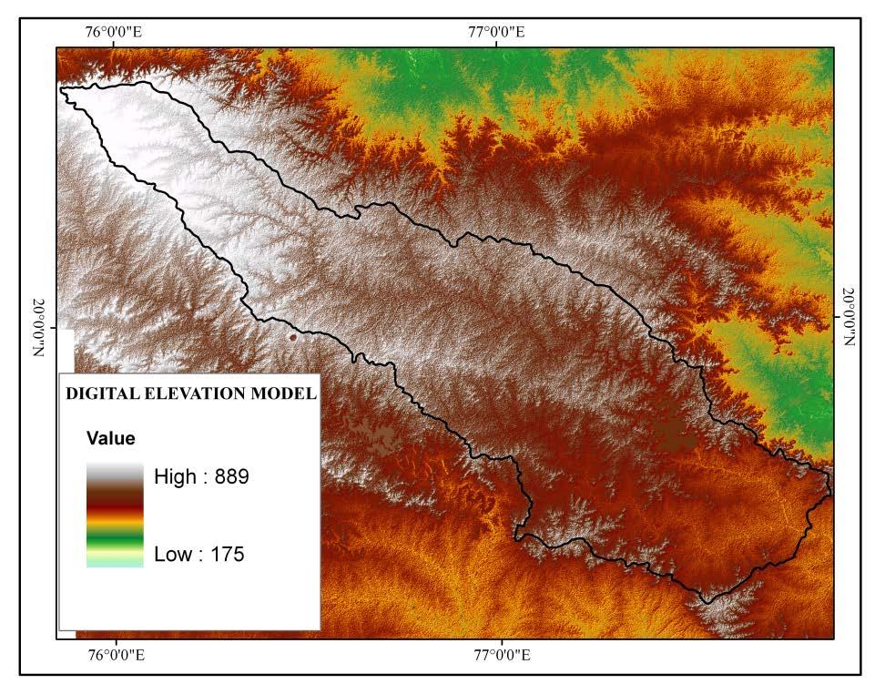
4 STUDY AREA Geographical Extent: 76ºE to 77ºE 20ºN to 21ºN Area : square km elevation ranges from m slope ranges from 0-50 Length of the river: 676 km Source : CWC Districts within the watershed: Buldhana, Yavatmal, Hingoli,Nanded and Washim. Mean Temperature in January :20-25 C Mean Temperature in April : 30 C Average annual rainfall: cm Periodic Droughts occur. 60% of the area is under agriculture.1/10 th of it receives irrigation. Wells irrigate 60%, Canals 20% and tanks 20% Major crops grown in this area are Cotton, Tuar/Arhar, Jowar, Gram, Wheat.
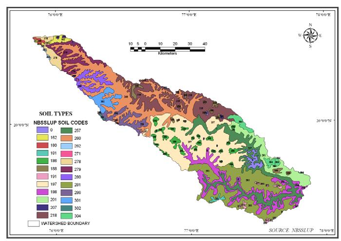
5 DATA SOURCE Monthly rainfall for the year were collected from Monthly Rainfall Report, India Meteorological Department (IMD) for the stations of Nanded, Buldana, Parbhani, Nagpur and Yavatmal. Land sat MSS data for 1976, Landsat TM data for 1990, Landsat TM data for 1999, and IRS P6 LISS III data for 2011 Daily precipitation, temperature, solar radiation, relative humidity and wind speed data for the year were procured from IMD for the stations of Buldana, Akola, Parbhani, Nagpur and Yavatmal situated near the watershed for modeling runoff for the different scenarios. Daily runoff data was collected from Central Water Commission (CWC) for the years for Marlegaon gauging site. For the years the daily solar radiation data was downloaded from and for the solar radiation data was downloaded from eosweb.larc.nasa.gov/cgi-bin/ssc/global.cgi? For the above stations to use in modeling purposes. www1.ncdc-noaa.gov/pub/data/ghcn/daily/gsn was used to download daily maximum minimum temperature, dew point temperature and daily precipitation for Akola and Nagpur for and was used to download the long term ( ) daily maximum minimum temperature and daily precipitation data for the stations of Buldana, Parbhani and Yeotmal. For the years 1975 to 2011 the daily wind data were downloaded for Akola and Nagpur from For the other stations of Buldana, Parbhani and Yeotmal the average monthly wind speed data were collected from Soil Map of 1:50,000 scale and Soil Characteristics data from National Bureau of Planning, Nagpur. Soil Survey and Land Use
6 TREND IN SEASONAL RAINFALL CONDITION
7 TREND IN SEASONAL RUNOFF CONDITION

8 METHODOLOGY LANDUSE LAND COVER CLASSIFICATION AND CHANGE DETECTION GENERATION OF NORMAL WEATHER PARAMETERS SIMULATION OF RUNOFF WITH ACTUAL WEATHER DATA OF ON THE LAND USE LAND COVER OF TO CALIBRATE THE MODEL SIMULATION OF RUNOFF WITH NORMAL WEATHER DATA ON DIFFERENT LAND USE SCENARIOS SPEARMAN RANK CORRELATION COFFICIENT BETWEEN CHANGING RUNOFF AND CHANGING LAND USE WAS CALCULATED

9 LAND USE LAND COVER CHANGES

10 LAND USE LAND COVER CHANGES LAND USE LAND COVER CHANGE MATRIX (IN %) BUILT UP AGRICULTURE CULTIVABLE LAND DENSE VEGETATION OPEN SCRUB WATERBODIES BUILT UP AGRICULTURE CURRENT FALLOW DENSE VEGETATION OPEN SCRUB WATERBODIES BUILT UP AGRICULTURE CULTIVABLE LAND DENSE VEGETATION OPEN SCRUB WATERBODIES BUILT UP AGRICULTURE CURRENT FALLOW DENSE VEGETATION OPEN SCRUB WATERBODIES BUILT UP AGRICULTURE CULTIVABLE LAND DENSE VEGETATION OPEN SCRUB WATERBODIES BUILT UP AGRICULTURE CURRENT FALLOW DENSE VEGETATION OPEN SCRUB WATERBODIES

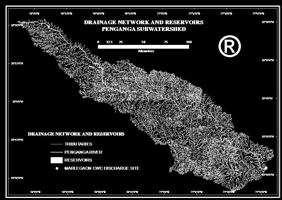
11 WATERBODIES AND HYDROLOGICAL STRUCTURES IN 1976
12 WATERBODIES AND HYDROLOGICAL STRUCTURES IN 1989
13 WATERBODIES AND HYDROLOGICAL STRUCTURES IN 1998
14 WATERBODIES AND HYDROLOGICAL STRUCTURES IN 2011
15 COMPUTATION OF DAILY NORMALS OF THE WEATHER PARAMETERS USED IN SWAT MODEL SOLAR RADIATION DAILY NORMAL SORAL RADIATION = DAILY SOLAR RADIATION FOR THE i th DAY OF A MONTH FOR ALL THE YEARS UNDER STUDY/ NUMBERS OF YEARS UNDER STUDY TEMPERATURE DAILY NORMAL MAXIMUM OR MINIMUM TEMPERATURE= DAILY MAXIMUM OR MINIMUM TEMPERATURE FOR THE i th DAY OF A MONTH FOR ALL THE YEARS UNDER STUDY/ NUMBERS OF YEARS UNDER STUDY PRECIPITATION FREQUENCY OF NON RAINY DAYS IN THE i th DAY OF A MONTH FOR ALL THE YEARS UNDER STUDY WERE COMPUTED IF 50 % OF THE YEARS UNDER STUDY HAVE EXPERIENCED BOTH RAINY AND NON RAINY DAYS, IT HAS BEEN ASSUMED TO BE A RAINY DAY. DAILY NORMAL RAINFALL= RAINFALL FOR THE i th RAINY DAY OF A MONTH FOR ALL THE YEARS UNDER STUDY/ NUMBERS OF YEARS UNDER STUDY RELATIVE HUMIDITY DAILY NORMAL RELATIVE HUMIDITY= RELATIVE HUMIDITY FOR THE i th DAY OF A MONTH FOR ALL THE YEARS UNDER STUDY/ NUMBERS OF YEARS UNDER STUDY WIND SPEED DAILY NORMAL WIND SPEED= WIND SPEED FOR THE ith DAY OF A MONTH FOR ALL THE YEARS UNDER STUDY/ NUMBERS OF YEARS UNDER STUDY
16 RUNOFF SIMULATION IN PREDAM AND POST DAM SCENARIOS WITH THE HELP OF SWAT HYDROLOGICAL MODEL SOLAR RADIATION TEMPERATURE WIND SPEED RELATIVE HUMIDITY EVAPOTRANSPIRATION PRECIPITATION INTERCEPTION LAND USE LAND COVER CONITIONS, CANOPY COVERAGE LAND COVER, SOIL, DEM, HYDROLOGICAL STRUCTURES RUNOFF / OVERLAND FLOW BYPASS FLOW GENERATION INFILTRATION/PERCOLATION GROUNDWATER SOIL, HYDROGEOLOGY CONDITIONS BASEFLOW

17 SWAT DATABASE COMPUTED FOR THE STUDY PHU MAXIMUM POSSIBLE SOIL CRACK VOLUME GROUND WATER DATABASE ALPHA_BF, SHALLST, DEEPEST GROUNDWATER MONITORING STATIONS,CGWB

18 WATERSHED DELINEATION
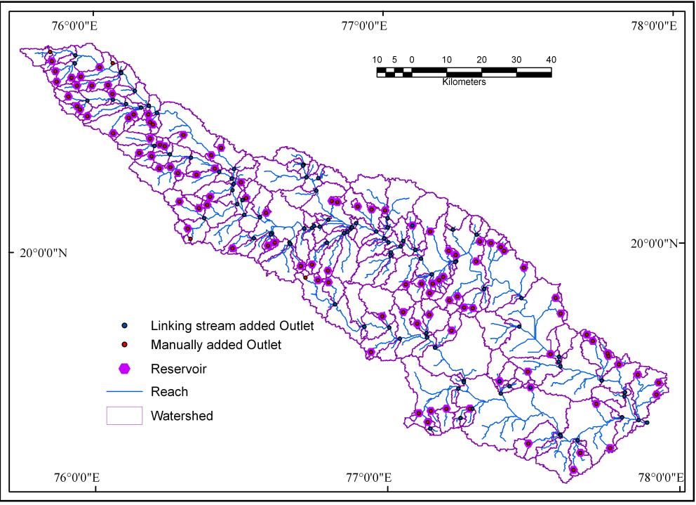
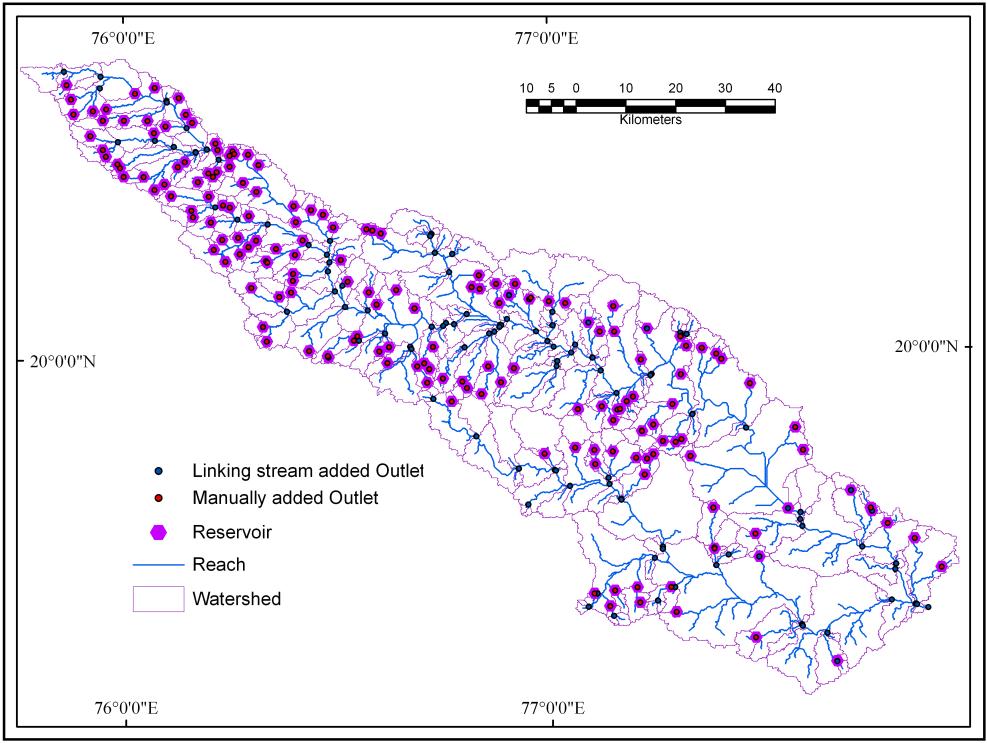

19 SUBBASINS DELINEATED

20 GENERATION OF HYDROLOGICAL RESPONSE UNITS
21 MODEL CALIBRATION

22 MODEL CALIBRATION (CONTD ) R 2 = 0.60 NSE= 0.40 SENSITIVE PARAMETERS PARAMETERS FOR MODEL CALIBRATION VALUES PHU 2459 ESCO 1 EPCO 0 GW_DELAY 245 ALPHA_BF SURLAG 24 CH_N CH_N
23 SIMULATED RUNOFF UNDER NORMAL WEATHER CONDITIONS
24 SPEARMAN RANK CORRELATION BETWEEN LAND USE AND RUNOFF CHANGES CHANGES IN LULC runoff runoff 11runoff BUILT UP Correlation Coefficient.285 **.152 *.236 ** AGRICULTURE Correlation Coefficient.588 **.139 * CULTIVABLE Correlation Coefficient ** LAND DENSE Correlation Coefficient ** VEGETATION OPENSCRUB Correlation Coefficient.609 ** WATER Correlation Coefficient.428 **.169 * **. Correlation is significant at the 0.01 level (2-tailed). *. Correlation is significant at the 0.05 level (2-tailed).
25 CONCLUSION The Dams are seen to have reduced the natural monsoon flow and have increased the post monsoon and pre monsoon flow at the Marlegaon gauging site and also all across the subwatershed The conversion of open scrub and barren area to an arable one has reduced the overland flow as well as the runoff. It is necessary to grow less water intensive crops to make the region sustainable
26
Hydrologic Modelling of the Upper Malaprabha Catchment using ArcView SWAT
 Hydrologic Modelling of the Upper Malaprabha Catchment using ArcView SWAT Technical briefs are short summaries of the models used in the project aimed at nontechnical readers. The aim of the PES India
July, International SWAT Conference & Workshops
 July, 212 212 International SWAT Conference & Workshops Hydrological Modelling of Kosi and Gandak Basins using SWAT Model S. Dutta, Pritam Biswas, Sangita Devi, Suresh A Karth and Bimlesh kumar, Ganga
MODULE 8 LECTURE NOTES 2 REMOTE SENSING APPLICATIONS IN RAINFALL-RUNOFF MODELLING
 MODULE 8 LECTURE NOTES 2 REMOTE SENSING APPLICATIONS IN RAINFALL-RUNOFF MODELLING 1. Introduction The most common application of the remote sensing techniques in the rainfall-runoff studies is the estimation
Uncertainty in the SWAT Model Simulations due to Different Spatial Resolution of Gridded Precipitation Data
 Uncertainty in the SWAT Model Simulations due to Different Spatial Resolution of Gridded Precipitation Data Vamsi Krishna Vema 1, Jobin Thomas 2, Jayaprathiga Mahalingam 1, P. Athira 4, Cicily Kurian 1,
IMPACT OF CLIMATE CHANGE OVER THE ARABIAN PENINSULA
 IMPACT OF CLIMATE CHANGE OVER THE ARABIAN PENINSULA By: Talal Alharbi June, 29 2017 1 Motivation: In arid and semi-arid regions of the world the demand for fresh water resources is increasing due to: increasing
Modelling Runoff with Satellite Data. Nyandwaro Gilbert Nyageikaro Patrick Willems Joel Kibiiy
 Modelling Runoff with Satellite Data Nyandwaro Gilbert Nyageikaro Patrick Willems Joel Kibiiy 1 Outline Background information SWAT model development The model sensitivity analysis and calibration Calibration
Effect of land use/land cover changes on runoff in a river basin: a case study
 Water Resources Management VI 139 Effect of land use/land cover changes on runoff in a river basin: a case study J. Letha, B. Thulasidharan Nair & B. Amruth Chand College of Engineering, Trivandrum, Kerala,
STREAM FLOW MODELING IN THE NACUNDAY RIVER BASIN (PARAGUAY, SOUTH AMERICA) USING SWAT MODEL. Sandra Mongelos and Manoj K. Jain
 USING SWAT MODEL. Sandra Mongelos and Manoj K. Jain") STREAM FLOW MODELING IN THE NACUNDAY RIVER BASIN (PARAGUAY, SOUTH AMERICA) USING SWAT MODEL Sandra Mongelos and Manoj K. Jain DEPARTMENT OF HYDROLOGY INDIAN INSTITUTE OF TECHNOLOGY ROORKEE ROORKEE 247
STREAM FLOW MODELING IN THE NACUNDAY RIVER BASIN (PARAGUAY, SOUTH AMERICA) USING SWAT MODEL Sandra Mongelos and Manoj K. Jain DEPARTMENT OF HYDROLOGY INDIAN INSTITUTE OF TECHNOLOGY ROORKEE ROORKEE 247
Study of Hydrometeorology in a Hard Rock Terrain, Kadirischist Belt Area, Anantapur District, Andhra Pradesh
 Open Journal of Geology, 2012, 2, 294-300 http://dx.doi.org/10.4236/ojg.2012.24028 Published Online October 2012 (http://www.scirp.org/journal/ojg) Study of Hydrometeorology in a Hard Rock Terrain, Kadirischist
Under the guidance of Prof.C S P Ojha
 A Presentation by KAUSHIKA G S Under the guidance of Prof.C S P Ojha HYDRAULICS ENGINEERING GROUP DEPARTMENT OF CIVIL ENGINEERING INDIAN INSTITUTE OF TECHNOLOGY ROORKEE ROORKEE 247 667, Uttarakhand, INDIA
Impact of different types of meteorological data inputs on predicted hydrological and erosive responses to projected land use change
 Impact of different types of meteorological data inputs on predicted hydrological and erosive responses to projected land use change Suman Bhattacharyya 1 & Joy Sanyal * 1 2 1 Department of Geography,
CHAPTER VII FULLY DISTRIBUTED RAINFALL-RUNOFF MODEL USING GIS
 80 CHAPTER VII FULLY DISTRIBUTED RAINFALL-RUNOFF MODEL USING GIS 7.1GENERAL This chapter is discussed in six parts. Introduction to Runoff estimation using fully Distributed model is discussed in first
VILLAGE INFORMATION SYSTEM (V.I.S) FOR WATERSHED MANAGEMENT IN THE NORTH AHMADNAGAR DISTRICT, MAHARASHTRA
 FOR WATERSHED MANAGEMENT IN THE NORTH AHMADNAGAR DISTRICT, MAHARASHTRA") VILLAGE INFORMATION SYSTEM (V.I.S) FOR WATERSHED MANAGEMENT IN THE NORTH AHMADNAGAR DISTRICT, MAHARASHTRA Abstract: The drought prone zone in the Western Maharashtra is not in position to achieve the agricultural
VILLAGE INFORMATION SYSTEM (V.I.S) FOR WATERSHED MANAGEMENT IN THE NORTH AHMADNAGAR DISTRICT, MAHARASHTRA Abstract: The drought prone zone in the Western Maharashtra is not in position to achieve the agricultural
Modeling of a River Basin Using SWAT Model and SUFI-2
 Modeling of a River Basin Using SWAT Model and SUFI-2 NINA OMANI MASOUD TAJRISHY AHMAD ABRISHAMCHI Sharif University of Technology, Tehran, Iran Karkheh Dam, Iran 1 Area of Gharasu Sub-basin : 5793 km2
Setting up SWAT for the Upper Amazon
 2014 International SWAT Conference Setting up SWAT for the Upper Amazon Michael Strauch, Martin Volk 2014 International SWAT Conference Porto de Galinhas, July 30 August 1, 2014 ISI-MIP2 Inter-Sectoral
Development of the Hydrologic Model
 Kick-off meeting on enhancing hydrological data management and exchange procedures Water and Climate Adaptation Plan (WATCAP) for Sava River Basin Development of the Hydrologic Model David Heywood Team
Analyzing spatial and temporal variation of water balance components in La Vi catchment, Binh Dinh province, Vietnam
 Analyzing spatial and temporal variation of water balance components in La Vi catchment, Binh Dinh province, Vietnam Nguyen Duy Liem, Vo Ngoc Quynh Tram, Nguyen Le Tan Dat, Nguyen Kim Loi Nong Lam University-
Near Real-Time Runoff Estimation Using Spatially Distributed Radar Rainfall Data. Jennifer Hadley 22 April 2003
 Near Real-Time Runoff Estimation Using Spatially Distributed Radar Rainfall Data Jennifer Hadley 22 April 2003 Introduction Water availability has become a major issue in Texas in the last several years,
Comparison of Flow Calibration Using NEXRAD and Surface Rain Gauge Data in ArcSWAT
 Comparison of Flow Calibration Using NEXRAD and Surface Rain Gauge Data in ArcSWAT Presenter: Aisha M. Sexton USDA-ARS-HRSL / UMD Coauthors: Ali Sadeghi, Raghavan Srinivasan, Adel Shirmohammadi, and Xuesong
Simulation of sedimentation rates using the SWAT model A case study of the Tarbela Dam, Upper Indus Basin
 Simulation of sedimentation rates using the SWAT model A case study of the Tarbela Dam, Upper Indus Basin Ahammad, H. I 1., Crosato A 2,3., Maskey, S 2., Masih, I 2,*, McClain, M 2. 1 Punjab Irrigation
Dr. S.SURIYA. Assistant professor. Department of Civil Engineering. B. S. Abdur Rahman University. Chennai
 Hydrograph simulation for a rural watershed using SCS curve number and Geographic Information System Dr. S.SURIYA Assistant professor Department of Civil Engineering B. S. Abdur Rahman University Chennai
GIS BASED HYDROLOGICAL MODELLING FOR CLIMATE CHANGE IMPACT ASSESSMENT. Dr. Amardeep Singh, MoWR Prof. A. K. Gosain, IIT Delhi
 GIS BASED HYDROLOGICAL MODELLING FOR CLIMATE CHANGE IMPACT ASSESSMENT Dr. Amardeep Singh, MoWR Prof. A. K. Gosain, IIT Delhi Model Description SWAT (Soil and Water Assessment Tool) Conceptual, distributed,
URBAN WATERSHED RUNOFF MODELING USING GEOSPATIAL TECHNIQUES
 URBAN WATERSHED RUNOFF MODELING USING GEOSPATIAL TECHNIQUES DST Sponsored Research Project (NRDMS Division) By Prof. M. GOPAL NAIK Professor & Chairman, Board of Studies Email: mgnaikc@gmail.com Department
Analysis of Rainfall and Other Weather Parameters under Climatic Variability of Parbhani ( )
") International Journal of Current Microbiology and Applied Sciences ISSN: 2319-7706 Volume 7 Number 06 (2018) Journal homepage: http://www.ijcmas.com Original Research Article https://doi.org/10.20546/ijcmas.2018.706.295
International Journal of Current Microbiology and Applied Sciences ISSN: 2319-7706 Volume 7 Number 06 (2018) Journal homepage: http://www.ijcmas.com Original Research Article https://doi.org/10.20546/ijcmas.2018.706.295
Danielle A. Bressiani 1, *, R. Srinivasan 2, E. M. Mendiondo 1,3 & K. C. Abbaspour 4
 2015 International SWAT Conference Pula, Sardinia, Italy Danielle A. Bressiani 1, *, R. Srinivasan 2, E. M. Mendiondo 1,3 & K. C. Abbaspour 4 1 Engineering School of São Carlos, University of São Paulo
Drought Assessment under Climate Change by Using NDVI and SPI for Marathwada
 Available online at www.ijpab.com ISSN: 2320 7051 Int. J. Pure App. Biosci. SPI: 6 (1): 1-5 (2018) Research Article Drought Assessment under Climate Change by Using NDVI and SPI for Marathwada A. U. Waikar
Geospatial Data Mining to Explore Watershed Development in Rainfed Regions
 Geospatial Data Mining to Explore Watershed Development in Rainfed Regions S. Nallan 1, L. Armstrong 1, Andreas Neuhaus 1,2, B. Croke 3, N. Dunstan 1,4 1 School of Computer and Security Science, Edith
Abstract: About the Author:
 REMOTE SENSING AND GIS IN LAND USE PLANNING Sathees kumar P 1, Nisha Radhakrishnan 2 1 1 Ph.D Research Scholar, Department of Civil Engineering, National Institute of Technology, Tiruchirappalli- 620015,
Climatic Change Implications for Hydrologic Systems in the Sierra Nevada
 Climatic Change Implications for Hydrologic Systems in the Sierra Nevada Part Two: The HSPF Model: Basis For Watershed Yield Calculator Part two presents an an overview of why the hydrologic yield calculator
Liliana Pagliero June, 15 th 2011
 Liliana Pagliero liliana.pagliero@jrc.ec.europa.eu June, 15 th 2011 2/18 SWAT MODELLING AT PAN EUROPEAN SCALE: THE DANUBE BASIN PILOT STUDY Introduction The Danube Model Available databases Model set up
Assessment of solid load and siltation potential of dams reservoirs in the High Atlas of Marrakech (Moorcco) using SWAT Model
 using SWAT Model") Assessment of solid load and siltation potential of dams reservoirs in the High Atlas of Marrakech (Moorcco) using SWAT Model Amal Markhi: Phd Student Supervisor: Pr :N.Laftrouhi Contextualization Facing
Assessment of solid load and siltation potential of dams reservoirs in the High Atlas of Marrakech (Moorcco) using SWAT Model Amal Markhi: Phd Student Supervisor: Pr :N.Laftrouhi Contextualization Facing
Chapter-1 Introduction
 Modeling of rainfall variability and drought assessment in Sabarmati basin, Gujarat, India Chapter-1 Introduction 1.1 General Many researchers had studied variability of rainfall at spatial as well as
Summary and Conclusions
 241 Chapter 10 Summary and Conclusions Kerala is situated in the southern tip of India between 8 15 N and 12 50 N latitude and 74 50 E and 77 30 E longitude. It is popularly known as Gods own country.
DEVELOPMENT OF A LARGE-SCALE HYDROLOGIC PREDICTION SYSTEM
 JP3.18 DEVELOPMENT OF A LARGE-SCALE HYDROLOGIC PREDICTION SYSTEM Ji Chen and John Roads University of California, San Diego, California ABSTRACT The Scripps ECPC (Experimental Climate Prediction Center)
Climate change analysis in southern Telangana region, Andhra Pradesh using LARS-WG model
 Climate change analysis in southern Telangana region, Andhra Pradesh using LARS-WG model K. S. Reddy*, M. Kumar, V. Maruthi, B. Umesha, Vijayalaxmi and C. V. K. Nageswar Rao Central Research Institute
Research Note COMPUTER PROGRAM FOR ESTIMATING CROP EVAPOTRANSPIRATION IN PUERTO RICO 1,2. J. Agric. Univ. P.R. 89(1-2): (2005)
: (2005)") Research Note COMPUTER PROGRAM FOR ESTIMATING CROP EVAPOTRANSPIRATION IN PUERTO RICO 1,2 Eric W. Harmsen 3 and Antonio L. González-Pérez 4 J. Agric. Univ. P.R. 89(1-2):107-113 (2005) Estimates of crop
Research Note COMPUTER PROGRAM FOR ESTIMATING CROP EVAPOTRANSPIRATION IN PUERTO RICO 1,2 Eric W. Harmsen 3 and Antonio L. González-Pérez 4 J. Agric. Univ. P.R. 89(1-2):107-113 (2005) Estimates of crop
Assessing climate change impacts on the water resources in Pune, India, using downscaling and hydrologic modeling
 Assessing climate change impacts on the water resources in Pune, India, using downscaling and hydrologic modeling 1, Tim G. Reichenau 1, Shamita Kumar 2, Karl Schneider 1 1 Hydrogeography and Climatology
Flood Forecasting Tools for Ungauged Streams in Alberta: Status and Lessons from the Flood of 2013
 Flood Forecasting Tools for Ungauged Streams in Alberta: Status and Lessons from the Flood of 2013 John Pomeroy, Xing Fang, Kevin Shook, Tom Brown Centre for Hydrology, University of Saskatchewan, Saskatoon
Long term weather trends in Phaltan, Maharashtra. French intern at NARI, student from Ecole Centrale de Lyon, Ecully 69130, France.
 Long term weather trends in Phaltan, Maharashtra A. Jacob and Anil K. Rajvanshi French intern at NARI, student from Ecole Centrale de Lyon, Ecully 693, France. Director NARI, Nimbkar Agricultural Research
RESEARCH NOTE Changing Dew Patterns in Anantapur District, Andhra Pradesh: A Generalistic Observation INTRODUCTION
 RESEARCH NOTE Changing Dew Patterns in Anantapur District, Andhra Pradesh: A Generalistic Observation R.V. Rama Mohan* I INTRODUCTION Ind. Jn. of Agri. Econ. Vol.67, No.4, Oct.-Dec. 212 Anantapur district
KEY WORDS: Palmer Meteorological Drought Index, SWAP, Kriging spatial analysis and Digital Map.
 PALMER METEOROLOGICAL DROUGHT CLASSIFICATION USING TECHNIQUES OF GEOGRAPHIC INFORMATION SYSTEM IN THAILAND S. Baimoung, W. Waranuchit, S. Prakanrat, P. Amatayakul, N. Sukhanthamat, A. Yuthaphan, A. Pyomjamsri,
I.J.E.M.S., VOL.4 (1) 2013: ISSN X
 2013: ISSN X") I.J.E.M.S., VOL.4 (1) 2013: 23-28 ISSN 2229-600X Patel Gautam. R., Patel Rajni J. & Chalodia Arvind L 1 Assistant Research Scientist, Directorate of Research, Anand Agricultural University, Anand-388 110.
I.J.E.M.S., VOL.4 (1) 2013: 23-28 ISSN 2229-600X Patel Gautam. R., Patel Rajni J. & Chalodia Arvind L 1 Assistant Research Scientist, Directorate of Research, Anand Agricultural University, Anand-388 110.
Lake Tahoe Watershed Model. Lessons Learned through the Model Development Process
 Lake Tahoe Watershed Model Lessons Learned through the Model Development Process Presentation Outline Discussion of Project Objectives Model Configuration/Special Considerations Data and Research Integration
VIC Hydrology Model Training Workshop Part II: Building a model
 VIC Hydrology Model Training Workshop Part II: Building a model 11-12 Oct 2011 Centro de Cambio Global Pontificia Universidad Católica de Chile Ed Maurer Civil Engineering Department Santa Clara University
Seasonal Rainfall Trend Analysis
 RESEARCH ARTICLE OPEN ACCESS Seasonal Rainfall Trend Analysis Devdatta V. Pandit Research Scholar, Dept. of SWCE, M.P.K.V, Rahuri- 413722, Ahmednagar. (M., India ABSTRACT This study aims to detect the
Changing Hydrology under a Changing Climate for a Coastal Plain Watershed
 Changing Hydrology under a Changing Climate for a Coastal Plain Watershed David Bosch USDA-ARS, Tifton, GA Jeff Arnold ARS Temple, TX and Peter Allen Baylor University, TX SEWRU Objectives 1. Project changes
SWAT WEATHER DATABASE TOOL
 A SUPPORT SYSTEM FOR THE LONG-TERM ANALYSIS OF CLIMATE SCENARIOS WITH SWAT Arthur H. Essenfelder Centro Euro-Mediterraneo sui Cambiamenti Climatici CMCC 2017 INTERNATIONAL SWAT CONFERENCE 28 30 JUNE 2017,
Appendix D. Model Setup, Calibration, and Validation
 . Model Setup, Calibration, and Validation Lower Grand River Watershed TMDL January 1 1. Model Selection and Setup The Loading Simulation Program in C++ (LSPC) was selected to address the modeling needs
Rainfall Analysis in Mumbai using Gumbel s Extreme Value Distribution Model
 Rainfall Analysis in Mumbai using Gumbel s Extreme Value Distribution Model S. Sangita Mishra 1, M. Solapure 2, R. Satpathy 3, K. Phadtare 4, S. Pawar 5 1 Assistant Professor, 2,3,4,5 Undergraduate students
GROUNDWATER CONFIGURATION IN THE UPPER CATCHMENT OF MEGHADRIGEDDA RESERVOIR, VISAKHAPATNAM DISTRICT, ANDHRA PRADESH
 GROUNDWATER CONFIGURATION IN THE UPPER CATCHMENT OF MEGHADRIGEDDA RESERVOIR, VISAKHAPATNAM DISTRICT, ANDHRA PRADESH Prof.P.Jagadeesara Rao Department of Geo-Engineering and Centre for Remote Sensing, College
Trends and Variability of Climatic Parameters in Vadodara District
 GRD Journals Global Research and Development Journal for Engineering Recent Advances in Civil Engineering for Global Sustainability March 2016 e-issn: 2455-5703 Trends and Variability of Climatic Parameters
Assessment of Meteorological Drought- A Case Study of Solapur District, Maharashtra, India
 Original Article Assessment of Meteorological Drought- A Case Study of Solapur District, Maharashtra, India Rajpoot Pushpendra Singh* 1 and Kumar Ajay 2 1 Research Scholar, Department of Physical Science,
GIS Based Delineation of Micro-watershed and its Applications: Mahendergarh District, Haryana
 Kamla-Raj 2012 J Hum Ecol, 38(2): 155-164 (2012) GIS Based Delineation of Micro-watershed and its Applications: Mahendergarh District, Haryana Gulshan Mehra and Rajeshwari * Department of Geography, Kurukshetra
Chiang Rai Province CC Threat overview AAS1109 Mekong ARCC
 Chiang Rai Province CC Threat overview AAS1109 Mekong ARCC This threat overview relies on projections of future climate change in the Mekong Basin for the period 2045-2069 compared to a baseline of 1980-2005.
ANALYSIS OF FLOODS AND DROUGHTS IN THE BAGO RIVER BASIN, MYANMAR, UNDER CLIMATE CHANGE
 ANALYSIS OF FLOODS AND DROUGHTS IN THE BAGO RIVER BASIN, MYANMAR, UNDER CLIMATE CHANGE Myo Myat Thu* MEE15631 ABSTRACT 1 Supervisor: Dr. Maskym Gusyev** Dr. Akira Hasegawa** This study investigates floods
Evaluation of the SWAT Model Setup Process Through A Case Study in Roxo Catchment, Portugal
 Evaluation of the SWAT Model Setup Process Through A Case Study in Roxo Catchment, Portugal Mustafa Gökmen Master Degree in on Geo-information and Earth Observation for Integrated Catchment and Water Resources
SPI: Standardized Precipitation Index
 PRODUCT FACT SHEET: SPI Africa Version 1 (May. 2013) SPI: Standardized Precipitation Index Type Temporal scale Spatial scale Geo. coverage Precipitation Monthly Data dependent Africa (for a range of accumulation
Change Detection in Landuse and landcover using Remote Sensing and GIS Techniques
 Change Detection in Landuse and landcover using Remote Sensing and GIS Techniques VEMU SREENIVASULU* and PINNAMANENI UDAYA BHASKAR Department of Civil Engineering Jawaharlal Nehru Technological University:
Using MODIS imagery to validate the spatial representation of snow cover extent obtained from SWAT in a data-scarce Chilean Andean watershed
 Using MODIS imagery to validate the spatial representation of snow cover extent obtained from SWAT in a data-scarce Chilean Andean watershed Alejandra Stehr 1, Oscar Link 2, Mauricio Aguayo 1 1 Centro
Forecasting of meteorological drought using ARIMA model
 Indian J. Agric. Res., 51 (2) 2017 : 103-111 Print ISSN:0367-8245 / Online ISSN:0976-058X AGRICULTURAL RESEARCH COMMUNICATION CENTRE www.arccjournals.com/www.ijarjournal.com Forecasting of meteorological
Influence of Micro-Climate Parameters on Natural Vegetation A Study on Orkhon and Selenge Basins, Mongolia, Using Landsat-TM and NOAA-AVHRR Data
 Cloud Publications International Journal of Advanced Remote Sensing and GIS 2013, Volume 2, Issue 1, pp. 160-172, Article ID Tech-102 ISSN 2320-0243 Research Article Open Access Influence of Micro-Climate
The agroclimatic resource change in Mongolia
 The agroclimatic resource change in Mongolia Azzaya D, Gantsetseg B, Munkhzul D Institute of Meteorology and Hydrology,Juulchny gudamj-5, Ulaanbaatar-46, Mongolia, 210646, meteoins@magicnet.mn, azzaya23@yahoo.com
Raktim Haldar Research Scholar Department of Civil Engineering Indian Institute of Technology, Delhi
 Raktim Haldar Research Scholar Department of Civil Engineering Indian Institute of Technology, Delhi Issues to be addressed Introduction to the Vembanad Lake and surrounding scenario of development Anthropogenic
DETECTION OF TREND IN RAINFALL DATA: A CASE STUDY OF SANGLI DISTRICT
 ORIGINAL ARTICLE DETECTION OF TREND IN RAINFALL DATA: A CASE STUDY OF SANGLI DISTRICT M. K. Patil 1 and D. N. Kalange 2 1 Associate Professor, Padmabhushan Vasantraodada Patil Mahavidyalaya, Kavathe- Mahankal,
Chapter- Three GEOMORPHOLOGY AND RAINFALL PATTERN
 Chapter- Three GEOMORPHOLOGY AND RAINFALL PATTERN 3.1 INTRODUCTION Geomorphology and its slope as a basic and applied science in general and as tool for searching groundwater resources in efficient geomorphological
Current and Future Plans. R. Srinivasan
 Current and Future Plans R. Srinivasan Contents 1 The ArcSWAT Interface 2 VizSWAT: Output Visualization 3 User online support 4 MapWindows SWAT interface 5 ArcGIS SWAT/APEX interfaces 6 Radar Rainfall
DROUGHT ASSESSMENT USING SATELLITE DERIVED METEOROLOGICAL PARAMETERS AND NDVI IN POTOHAR REGION
 DROUGHT ASSESSMENT USING SATELLITE DERIVED METEOROLOGICAL PARAMETERS AND NDVI IN POTOHAR REGION Researcher: Saad-ul-Haque Supervisor: Dr. Badar Ghauri Department of RS & GISc Institute of Space Technology
An Approach to analyse Drought occurrences using Geospatial Techniques
 An Approach to analyse Drought occurrences using Geospatial Techniques Shuchi Mala 1, Mahesh Kumar Jat 2, Parul Pradhan 3 1 Research Scholar, Malaviya National Institute of Technology Jaipur 2 Associate
Weather and climate outlooks for crop estimates
 Weather and climate outlooks for crop estimates CELC meeting 2016-04-21 ARC ISCW Observed weather data Modeled weather data Short-range forecasts Seasonal forecasts Climate change scenario data Introduction
Spatial and Temporal Analysis of Rainfall Variation in Yadalavagu Hydrogeological unit using GIS, Prakasam District, Andhra Pradesh, India
 International Research Journal of Environment Sciences ISSN 2319 1414 Spatial and Temporal Analysis of Rainfall Variation in Yadalavagu Hydrogeological unit using GIS, Prakasam District, Andhra Pradesh,
Estimation of Wavelet Based Spatially Enhanced Evapotranspiration Using Energy Balance Approach
 Estimation of Wavelet Based Spatially Enhanced Evapotranspiration Using Energy Balance Approach Dr.Gowri 1 Dr.Thirumalaivasan 2 1 Associate Professor, Jerusalem College of Engineering, Department of Civil
The Importance of Snowmelt Runoff Modeling for Sustainable Development and Disaster Prevention
 The Importance of Snowmelt Runoff Modeling for Sustainable Development and Disaster Prevention Muzafar Malikov Space Research Centre Academy of Sciences Republic of Uzbekistan Water H 2 O Gas - Water Vapor
CHAPTER 4 METHODOLOGY
 71 CHAPTER 4 METHODOLOGY 4.1 GENERAL Drought, a vague phenomenon, has been defined and analyzed in various ways. Drought assessment involves analysis of spatially and temporally varying water related data.
Rainfall is the major source of water for
 RESEARCH PAPER: Assessment of occurrence and frequency of drought using rainfall data in Coimbatore, India M. MANIKANDAN AND D.TAMILMANI Asian Journal of Environmental Science December, 2011 Vol. 6 Issue
[Penumaka, 7(1): January-March 2017] ISSN Impact Factor
![[Penumaka, 7(1): January-March 2017] ISSN Impact Factor](/thumbs/95/124653515.jpg "[Penumaka, 7(1): January-March 2017] ISSN Impact Factor") INTERNATIONAL JOURNAL OF ENGINEERING SCIENCES &MANAGEMENT HYDROGEOMORPHOLOGY OF CHEVELLA BASIN, RANGA REDDY DISTRICT, TELANGANA STATE Penumaka Ramesh* 1 & Podila Sankara Pitchaiah 2 * 1&2 Department of
INTERNATIONAL JOURNAL OF ENGINEERING SCIENCES &MANAGEMENT HYDROGEOMORPHOLOGY OF CHEVELLA BASIN, RANGA REDDY DISTRICT, TELANGANA STATE Penumaka Ramesh* 1 & Podila Sankara Pitchaiah 2 * 1&2 Department of
CHAPTER-11 CLIMATE AND RAINFALL
 CHAPTER-11 CLIMATE AND RAINFALL 2.1 Climate Climate in a narrow sense is usually defined as the "average weather", or more rigorously, as the statistical description in terms of the mean and variability
Inter-linkage case study in Pakistan
 7 th GEOSS Asia Pacific Symposium GEOSS AWCI Parallel Session: 26-28 May, 2014, Tokyo, Japan Inter-linkage case study in Pakistan Snow and glaciermelt runoff modeling in Upper Indus Basin of Pakistan Maheswor
Geostatistical Analysis of Rainfall Temperature and Evaporation Data of Owerri for Ten Years
 Atmospheric and Climate Sciences, 2012, 2, 196-205 http://dx.doi.org/10.4236/acs.2012.22020 Published Online April 2012 (http://www.scirp.org/journal/acs) Geostatistical Analysis of Rainfall Temperature
Effect of rainfall and temperature on rice yield in Puri district of Odisha in India
 2018; 7(4): 899-903 ISSN (E): 2277-7695 ISSN (P): 2349-8242 NAAS Rating: 5.03 TPI 2018; 7(4): 899-903 2018 TPI www.thepharmajournal.com Received: 05-02-2018 Accepted: 08-03-2018 A Baliarsingh A Nanda AKB
Seasonal Hydrological Forecasting in the Berg Water Management Area of South Africa
 Seasonal Hydrological Forecasting in the Berg Water Management Area of South Africa Trevor LUMSDEN and Roland SCHULZE University of KwaZulu-Natal, South Africa OUTLINE Introduction Objectives Study Area
REMOTE SENSING AND GIS APPLICATIONS FOR TERRAIN EVALUATION AND LAND RESOURCES ASSESSMENT IN YERALA RIVER BASIN, WESTERN MAHARASHTRA, INDIA
 International Journal of Civil, Structural, Environmental and Infrastructure Engineering Research and Development (IJCSEIERD) ISSN 2249-6866 Vol.2, Issue 2 June 2012 17-24 TJPRC Pvt. Ltd., REMOTE SENSING
Application of SWAT for the modelling of sediment yield at Pong reservoir, India
 Application of SWAT for the modelling of sediment yield at Pong reservoir, India A. R. Senthil kumar Tanmoyee Bhattacharya Suhas D Khobragade Manohar Arora National Institute of Hydrology Roorkee-247667,
THE RAINWATER HARVESTING SYMPOSIUM 2015
 THE RAINWATER HARVESTING SYMPOSIUM 2015 Remote Sensing for Rainwater Harvesting and Recharge Estimation under Data Scarce Conditions Taye Alemayehu Ethiopian Institute of Water Resources, Metameta Research
LAND USE AND LAND COVER ANALYSIS USING 8- BAND DATA: A CASE STUDY OF BELGAUM CITY AND ITS SURROUNDING.
 LAND USE AND LAND COVER ANALYSIS USING 8- BAND DATA: A CASE STUDY OF BELGAUM CITY AND ITS SURROUNDING. Mrs. Rita Basanna *, Dr. A.K. Wodeyar ** ABSTRACT Monitoring land-use change has become an important
Hands On Applications of the Latin American and Caribbean Flood and Drought Monitor (LACFDM)
") Hands On Applications of the Latin American and Caribbean Flood and Drought Monitor (LACFDM) Colby Fisher, Eric F Wood, Justin Sheffield, Nate Chaney Princeton University International Training: Application
Hands On Applications of the Latin American and Caribbean Flood and Drought Monitor (LACFDM) Colby Fisher, Eric F Wood, Justin Sheffield, Nate Chaney Princeton University International Training: Application
Impacts of precipitation interpolation on hydrologic modeling in data scarce regions
 Impacts of precipitation interpolation on hydrologic modeling in data scarce regions 1, Shamita Kumar, Florian Wilken 1, Peter Fiener 1 and Karl Schneider 1 1 Hydrogeography and Climatology Research Group,
Drought Criteria. Richard J. Heggen Department of Civil Engineering University of New Mexico, USA Abstract
 Drought Criteria Richard J. Heggen Department of Civil Engineering University of New Mexico, USA rheggen@unm.edu Abstract Rainwater catchment is an anticipatory response to drought. Catchment design requires
Building a European-wide hydrological model
 Building a European-wide hydrological model 2010 International SWAT Conference, Seoul - South Korea Christine Kuendig Eawag: Swiss Federal Institute of Aquatic Science and Technology Contribution to GENESIS
Soil Erosion Calculation using Remote Sensing and GIS in Río Grande de Arecibo Watershed, Puerto Rico
 Soil Erosion Calculation using Remote Sensing and GIS in Río Grande de Arecibo Watershed, Puerto Rico Alejandra M. Rojas González Department of Civil Engineering University of Puerto Rico at Mayaguez.
Comparison of GIS based SCS-CN and Strange table Method of Rainfall-Runoff Models for Veeranam Tank, Tamil Nadu, India.
 International Journal of Scientific & Engineering Research, Volume 3, Issue 10, October-2012 1 Comparison of GIS based SCS-CN and Strange table Method of Rainfall-Runoff Models for Veeranam Tank, Tamil
INTERNATIONAL JOURNAL OF GEOMATICS AND GEOSCIENCES Volume 4, No 4, 2014
 INTERNATIONAL JOURNAL OF GEOMATICS AND GEOSCIENCES Volume 4, No 4, 2014 Copyright 2010 All rights reserved Integrated Publishing services Research article ISSN 0976 4380 Land use/land cover change detection:
QUANTITATIVE ANALYSIS OF HYDROLOGIC CYCLE IN COLD SNOWY BASIN
 QUANTITATIVE ANALYSIS OF HYDROLOGIC CYCLE IN COLD SNOWY BASIN Tomohide USUTANI 1 and Makoto NAKATSUGAWA 2 1 Japan Weather Association, Sapporo, Japan 2 Toyohashi Office of River Works, Ministry of Land,
Climate Variability in South Asia
 Climate Variability in South Asia V. Niranjan, M. Dinesh Kumar, and Nitin Bassi Institute for Resource Analysis and Policy Contents Introduction Rainfall variability in South Asia Temporal variability
Description DESCRIPTION
 DESCRIPTION The location of the Upper James Watershed is located in northeastern South Dakota as well as southeastern North Dakota. It includes the following counties located in North Dakota Barnes, Dickey,
Analysis of meteorological measurements made over three rainy seasons in Sinazongwe District, Zambia.
 Analysis of meteorological measurements made over three rainy seasons in Sinazongwe District, Zambia. 1 Hiromitsu Kanno, 2 Hiroyuki Shimono, 3 Takeshi Sakurai, and 4 Taro Yamauchi 1 National Agricultural
NATIONAL HYDROPOWER ASSOCIATION MEETING. December 3, 2008 Birmingham Alabama. Roger McNeil Service Hydrologist NWS Birmingham Alabama
 NATIONAL HYDROPOWER ASSOCIATION MEETING December 3, 2008 Birmingham Alabama Roger McNeil Service Hydrologist NWS Birmingham Alabama There are three commonly described types of Drought: Meteorological drought
Development of the Regression Model to Predict Pigeon Pea Yield Using Meteorological Variables for Marathwada Region (Maharashtra)
") Available online at www.ijpab.com Singh et al Int. J. Pure App. Biosci. 5 (6): 1627-1631 (2017) ISSN: 2320 7051 DOI: http://dx.doi.org/10.18782/2320-7051.5445 ISSN: 2320 7051 Int. J. Pure App. Biosci.
Available online at www.ijpab.com Singh et al Int. J. Pure App. Biosci. 5 (6): 1627-1631 (2017) ISSN: 2320 7051 DOI: http://dx.doi.org/10.18782/2320-7051.5445 ISSN: 2320 7051 Int. J. Pure App. Biosci.
Improved ensemble representation of soil moisture in SWAT for data assimilation applications
 Improved ensemble representation of soil moisture in SWAT for data assimilation applications Amol Patil and RAAJ Ramsankaran Hydro-Remote Sensing Applications (H-RSA) Group, Department of Civil Engineering
SWIM and Horizon 2020 Support Mechanism
 SWIM and Horizon 2020 Support Mechanism Working for a Sustainable Mediterranean, Caring for our Future REG-7: Training Session #1: Drought Hazard Monitoring Example from real data from the Republic of
Frequency analysis of rainfall deviation in Dharmapuri district in Tamil Nadu
 Indian Journal of Geo Marine Sciences Vol.46 (8), August 217, pp. 171-1714 Frequency analysis of rainfall deviation in Dharmapuri district in Tamil Nadu V. Rajendran 1* & R. Venkatasubramani 2 1 Department