Environment Canada Modelling Systems and the 2013 Alberta Floods
|
|
|
- Aileen Jade Hutchinson
- 6 years ago
- Views:
Transcription
 Nick Kouwen (UW) Anthony Liu (EC) Muluneh Mekonnen (AB) Ron Goodison (EC) EC Montreal (CMC, RPN, National Lab) 2/24/2014 Page 1")
1 Environment Canada Modelling Systems and the 2013 Alberta Floods Calgary, Alberta February 19, 2014 Bruce Davison (EC) Al Pietroniro (EC) Nick Kouwen (UW) Anthony Liu (EC) Muluneh Mekonnen (AB) Ron Goodison (EC) EC Montreal (CMC, RPN, National Lab) 2/24/2014 Page 1
2 Overview EC Numerical Weather Prediction Systems Precipitation Forecasts and Analysis During the Flood Hydrological Modelling Systems Streamflow Hindcasts of the Flood 2/24/2014 Page 2
3 Existing EC Products The CMC Numerical Output Database CaPA HRDPS RDPS REPS GEPS NAEFS Seasonal forecasting system
 at two")
4 Observations at Calgary and Banff during the 2013 Southern Alberta Floods Daily precipitation amounts (from noon the previous day to noon the current day) at two measurement sites


5 Published precipitation map Max. precip: over 300 mm CaPA precipitation map June 16 June 30, 2013 Max. precip.: 221 mm


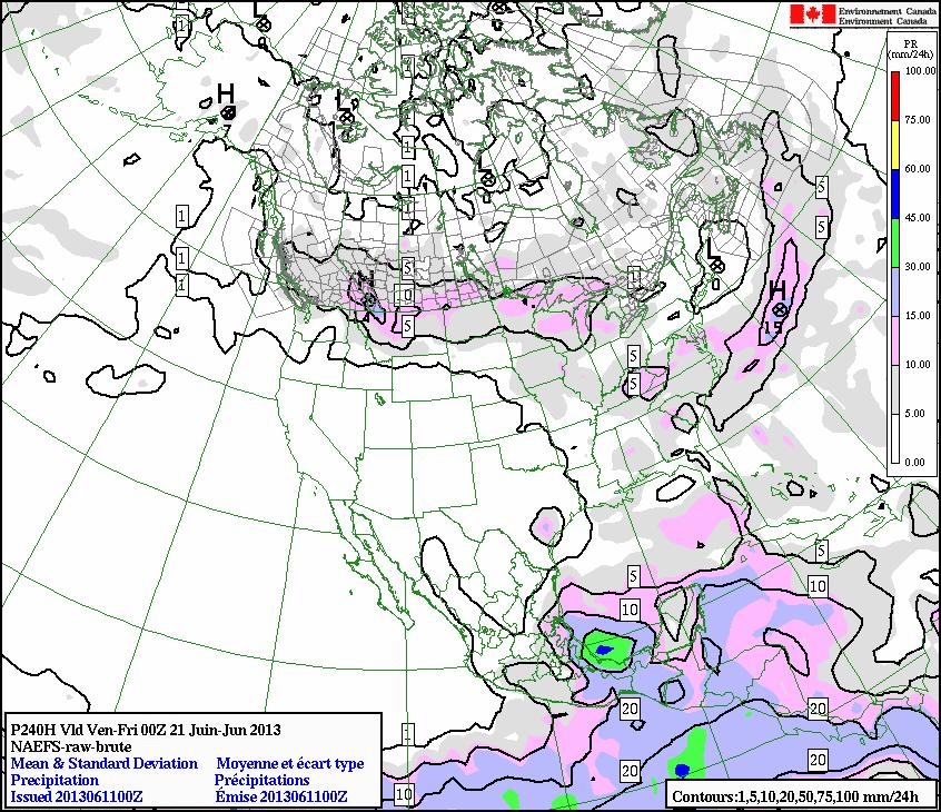
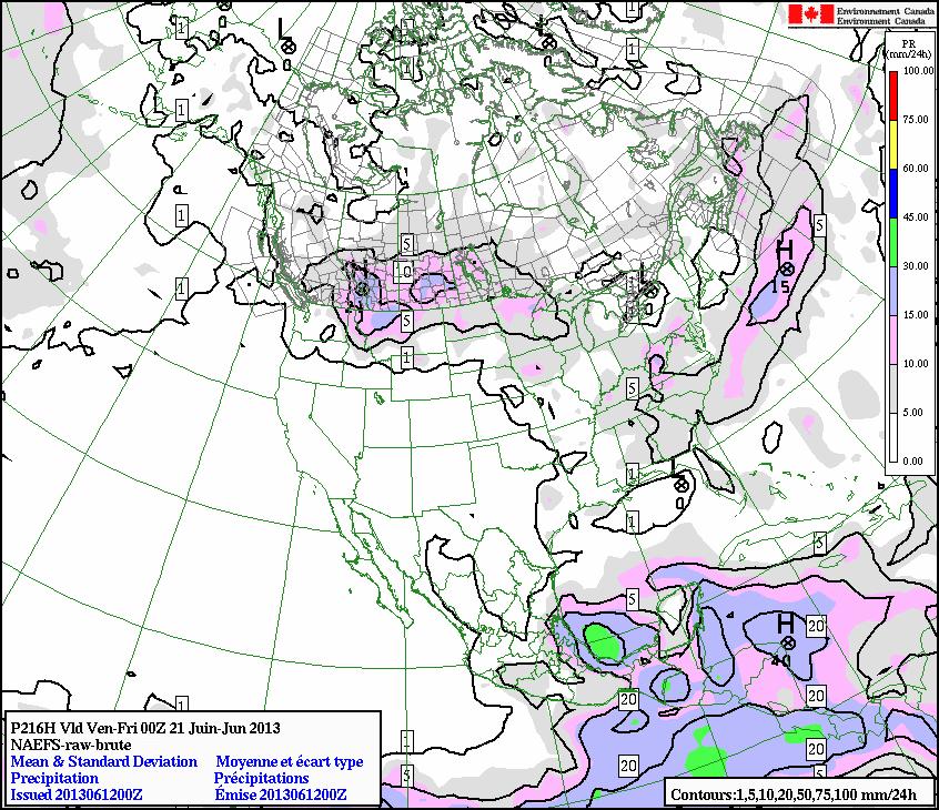

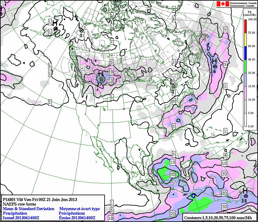
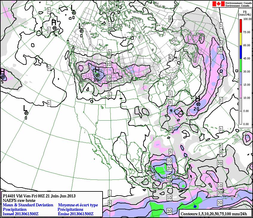
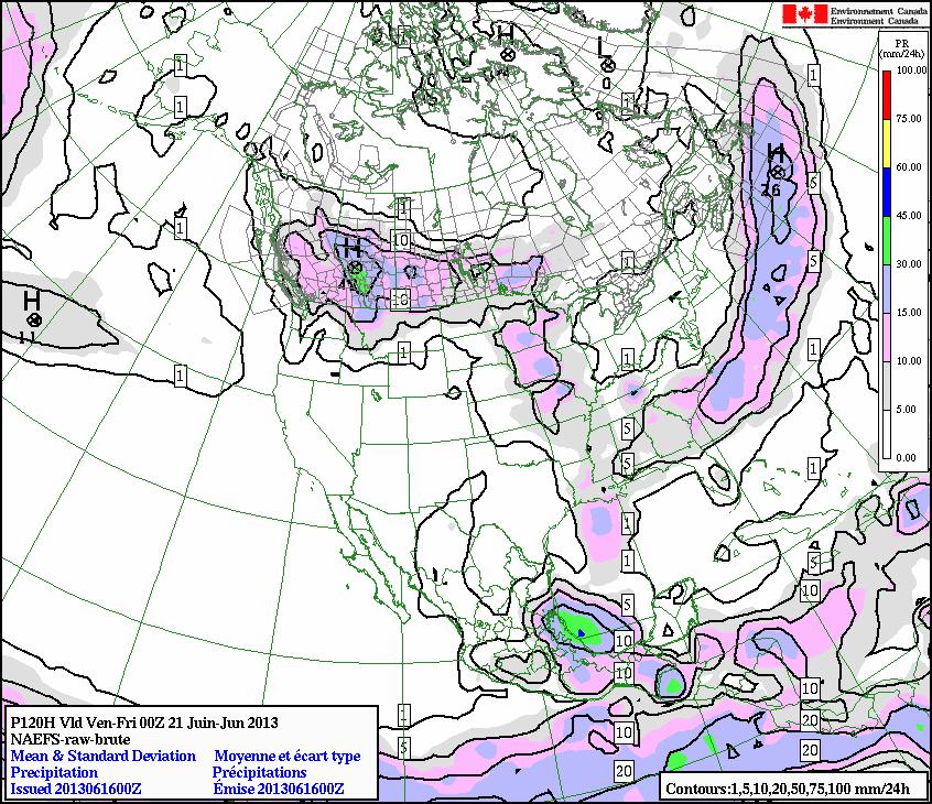
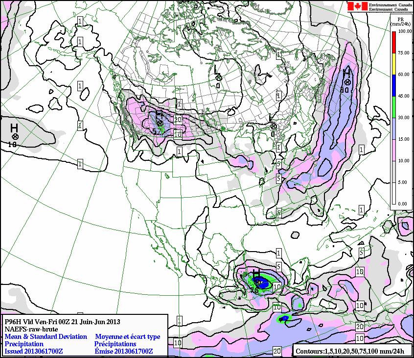
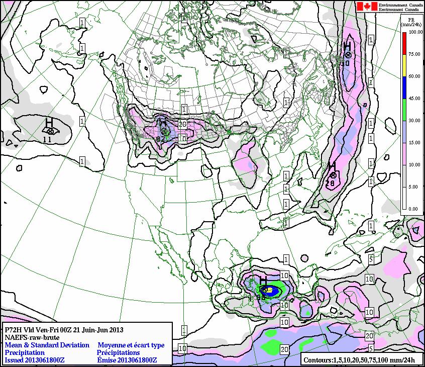
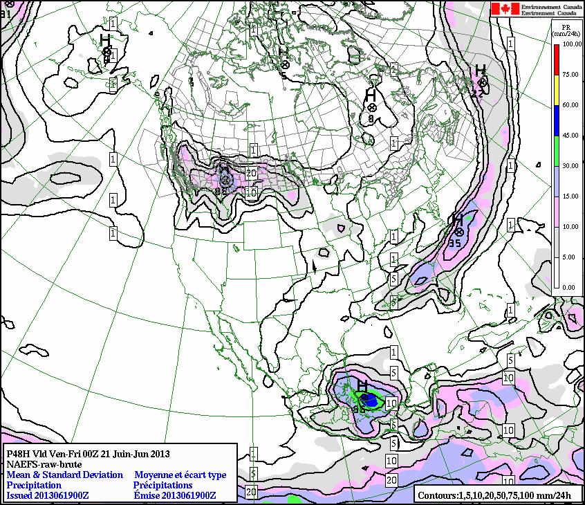
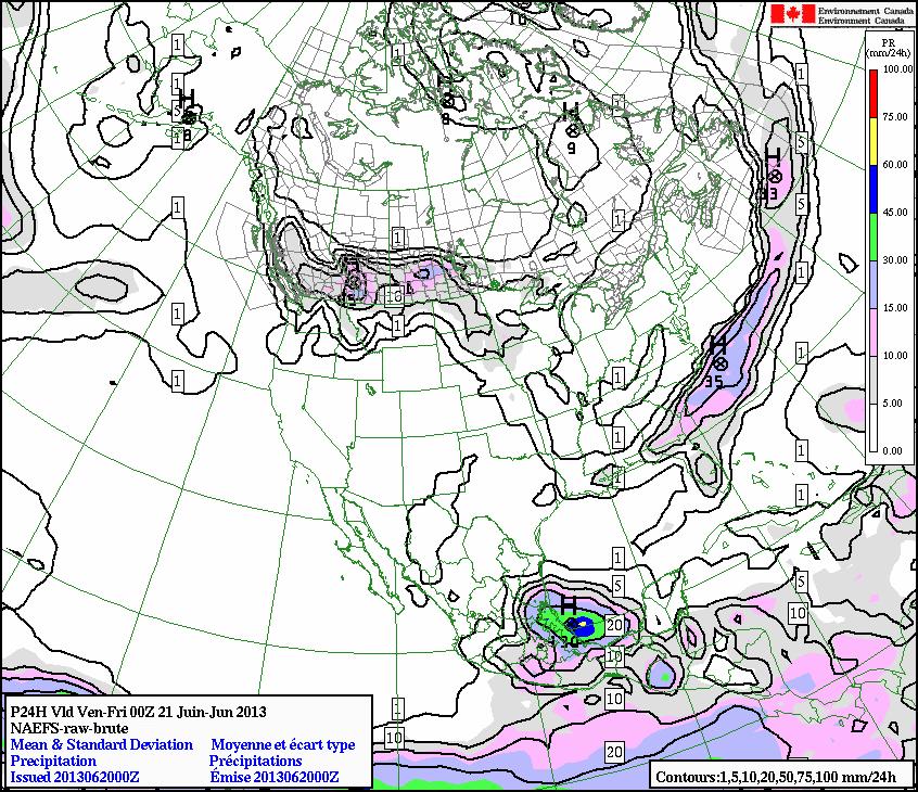
6 NAEFS 24H QPF Ending at 00Z 21 June 2013
7 Performance of Forecasting Systems during the 2013 Southern Alberta Floods At the medium-range (7-day lead time) The North American Ensemble Forecasting System (NAEFS) unambiguously forecasted strong precipitation over the area of interest Calgary June 2013
8 Performance of Forecasting Systems during the 2013 Southern Alberta Floods At the medium-range (5- to 10-day lead time) The experimental Extreme Forecast Index (EFI) calculated from the Global Ensemble Prediction System clearly indicated the possibility of extreme precipitation
9 Performance of Forecasting Systems during the 2013 Southern Alberta Floods At the short-range (3-day lead time) The Regional Ensemble Prediction System (REPS) indicated the probability of heavy precipitation (regions with 90% chances of at least 40 mm in 24 hours)
 forecasted extreme precipitations over significant areas Precipitation accumulation from 19 June 12Z to 22")
10 Performance of Forecasting Systems during the 2013 Southern Alberta Floods At the short-range (1-day lead time) The Regional Deterministic Prediction System (10-km grid spacing) forecasted extreme precipitations over significant areas Precipitation accumulation from 19 June 12Z to 22 June 12Z

11 Performance of Forecasting Systems during the 2013 Southern Alberta Floods At the short-range (1-day lead time) The High-Resolution Deterministic Prediction System (2.5-km grid spacing) forecasted extreme precipitations over significant areas Precipitation accumulation from 19 June 12Z to 22 June 12Z

12 Performance of Forecasting Systems during the 2013 Southern Alberta Floods Difference (HRDPS RDPS)
13 Hydrologic Modelling Systems Second Generation Land Surface Scheme SENSIBLE EXCHANGE Aerodynamic resistance ( r a ) Wind Leaf Drip T g Surface Soil Temperature Lower Soil Temperature Root Distribution Fn ( vegetation type) T gb CLASS WATFLOOD MESH RADIATIVE MOISTURE EXCHANGE EXCHANGE IR up r a Ponded Water Evaporation Infiltration Overland Flow α veg Interception Layer 1 Transpiration Leaves LAI Stomata T c Canopy Percolation Temperature and humidity r s ( light sensitivity Layer 2 changes r s ) Fraction vegetation cover & LAI IR down Fn ( temperature & season) IR up Stems SAI Infiltration Surface α soil Runoff Snow Fn ( soil wetness) Upper layer Upper soil layer wetness Full soil column Full column wetness CLASS WATFLOOD Layer 3 UZS Drainage LZS Interflow Base Flow Sellers et al Subsurface Runoff Sub-grid Variability Grid Square Computational Unit = Grid Square a c Individual Pixels Computational Unit = GRU Mixture of 4 sub-areas CS C GS G b Kouwen et al Mixture of 4 sub-areas CS C GS G Blend of 5 vegetation groups Blend of 5 vegetation groups

14 The MESH Modelling Platform 2/24/2014 Page 14
15 The approach - WATFLOOD Use existing watershed Manitoba Hydro WATFLOOD model for the headwaters of the North & South Saskatchewan rivers Convert CaPA precipitation and temperature data form its native format to Green Kenue (GK) r2c formats Re-calibrate the model parameters for the CaPA met data for Model the 2013 Calgary flood
16
17 Model calibration approach The usual approach to calibrating WATFLOOD is to first obtain the proper overall volume using only those parameters that affect evapotranspiration, sublimation and lake evaporation The nest step is to adjust the timing of the hydrographs The next slides show the result of 10 Dynamically Dimensioned Search (DDS) runs with WATFLOOD
18 800 Computed Flow Observed Flow 33-05BH004 BOW RIVER AT CALGARY 7868 km^2 Dv = % 600 cms BB001 BOW RIVER AT BANFF 2210 km^2 200 cms 100 Dv = %
19 1000 Computed Flow Observed Flow 33-05BH004 BOW RIVER AT CALGARY 7868 km^2 Dv = % cms BB001 BOW RIVER AT BANFF 2210 km^2 200 cms Dv = %
20 Computed Flow Observed Flow 2000 Dv = -1.9 % 33-05BH004 BOW RIVER AT CALGARY 7868 km^ cms BB001 BOW RIVER AT BANFF 2210 km^2 400 cms 300 Dv = %
21 Dv = % Qlz SIM OBS BH004 BOW RIVER AT CALGARY 7868 km^2 cms BB001 BOW RIVER AT BANFF 2210 km^2 cms 400 Dv = %
22 The approach - MESH Use existing watershed MESH model for the South Saskatchewan River Convert CaPA precipitation and temperature data form its native format to Green Kenue (GK) r2c formats Calibrated the model parameters for the CaPA met data for Oct 2004 Oct 2006 Calibrated the model on other sub-basins Model the 2013 Calgary flood
23 Standalone MESH run Really a spatial validation
Water Cycle Prediction on the Prairies
 Water Cycle Prediction on the Prairies A. Pietroniro, S. Marin, A. Liu, B. Davison, B. Toth, D. Shaw(AAFC), L. Martz Hydrometerology and Arctic Lab, Environment Canada, NHRC and Centre for Hydrology, University
ECCC/CCMEP variable resolution modelling of the Hudson Bay watershed
 ECCC/CCMEP variable resolution modelling of the Hudson Bay watershed Vincent Fortin (and many collaborators) Division de la recherche en météorologie Environnement en Changement climatique Canada GEM-based
12 SWAT USER S MANUAL, VERSION 98.1
 12 SWAT USER S MANUAL, VERSION 98.1 CANOPY STORAGE. Canopy storage is the water intercepted by vegetative surfaces (the canopy) where it is held and made available for evaporation. When using the curve
Toward a Water Cycle Prediction Program: Overview
 Toward a Water Cycle Prediction Program: Overview Alain Pietroniro, Chris Spence and Bruce Davison National Water Research Institute,HAL NHRC, Saskatoon Pierre Pellerin, Vincent Fortin RPN: Numerical prediction
Flood Forecasting Tools for Ungauged Streams in Alberta: Status and Lessons from the Flood of 2013
 Flood Forecasting Tools for Ungauged Streams in Alberta: Status and Lessons from the Flood of 2013 John Pomeroy, Xing Fang, Kevin Shook, Tom Brown Centre for Hydrology, University of Saskatchewan, Saskatoon
Soil Moisture Prediction and Assimilation
 Soil Moisture Prediction and Assimilation Analysis and Prediction in Agricultural Landscapes Saskatoon, June 19-20, 2007 STEPHANE BELAIR Meteorological Research Division Prediction and Assimilation Atmospheric
APPLICATIONS OF DOWNSCALING: HYDROLOGY AND WATER RESOURCES EXAMPLES
 APPLICATIONS OF DOWNSCALING: HYDROLOGY AND WATER RESOURCES EXAMPLES Dennis P. Lettenmaier Department of Civil and Environmental Engineering For presentation at Workshop on Regional Climate Research NCAR
Daytime long-wave radiation approximation for physical hydrological modelling of snowmelt: a case study of southwestern Ontario
 Soil-Vegetation-Atmosphere Transfer Schemes and Large-Scale Hydrological Models (Proceedings of a symposium held during tile Sixth I AI IS Scientific Assembly at Maastricht, The Netherlands. July 2001).
Land-Surface-Hydrological Models for Environmental Prediction
 Land-Surface-Hydrological Models for Environmental Prediction Dr. Alain Pietroniro P.Eng. Director Water Survey of Canada Environment Canada Dr. John Pomeroy Centre for Hydrology University of Saskatchewan
Mackenzie River delta North of Inuvik
 Hydrological Modelling with Green Kenue and WATFLOOD MRBB Workshop Edmonton, June 7, 2016 Nicholas Kouwen PhD., P.Eng., FASCE Mackenzie River delta North of Inuvik Bennet Dam Williston Lake Peace River
The Canadian Precipitation Analysis (CaPA) and the Canadian Land Data Assimilation System (CaLDAS)
 and the Canadian Land Data Assimilation System (CaLDAS)") The Canadian Precipitation Analysis (CaPA) and the Canadian Land Data Assimilation System (CaLDAS) Vincent Fortin (and many collaborators) Division de la recherche en météorologie Environnement en Changement
The Canadian Precipitation Analysis (CaPA) and the Canadian Land Data Assimilation System (CaLDAS) Vincent Fortin (and many collaborators) Division de la recherche en météorologie Environnement en Changement
Using the MESH modelling system for hydrological ensemble forecasting of the Laurentian Great Lakes at the regional scale
 Using the MESH modelling system for hydrological ensemble forecasting of the Laurentian Great Lakes at the regional scale Alain Pietroniro 1, Vincent Fortin 2, Nicholas Kouwen 3, Champa Neal 4, Richard
Analysis of real-time prairie drought monitoring and forecasting system. Lei Wen and Charles A. Lin
 Analysis of real-time prairie drought monitoring and forecasting system Lei Wen and Charles A. Lin Back ground information A real-time drought monitoring and seasonal prediction system has been developed
Development of the Hydrologic Model
 Kick-off meeting on enhancing hydrological data management and exchange procedures Water and Climate Adaptation Plan (WATCAP) for Sava River Basin Development of the Hydrologic Model David Heywood Team
Preliminary Runoff Outlook February 2018
 Preliminary Runoff Outlook February 2018 Prepared by: Flow Forecasting & Operations Planning Water Security Agency General Overview The Water Security Agency (WSA) is preparing for 2018 spring runoff including
Lecture 6: Precipitation Averages and Interception
 Lecture 6: Precipitation Averages and Interception Key Questions 1. How much and when does Whatcom County receive rain? 2. Where online can you find rainfall data for the state? 3. How is rainfall averaged
MET 3102-U01 PHYSICAL CLIMATOLOGY (ID 17901) Lecture 14
 Lecture 14") MET 3102-U01 PHYSICAL CLIMATOLOGY (ID 17901) Lecture 14 The hydrologic cycle evaporation vapor transport precipitation precipitation evaporation runoff Evaporation, precipitation, etc. in cm Vapor transported
MET 3102-U01 PHYSICAL CLIMATOLOGY (ID 17901) Lecture 14 The hydrologic cycle evaporation vapor transport precipitation precipitation evaporation runoff Evaporation, precipitation, etc. in cm Vapor transported
Hydrological Modeling of the Upper South Saskatchewan River Basin: Multi-basin Calibration and Gauge De-clustering Analysis
 Hydrological Modeling of the Upper South Saskatchewan River Basin: Multi-basin Calibration and Gauge De-clustering Analysis by Cameron Dunning A thesis presented to the University of Waterloo in fulfillment
Snow Melt with the Land Climate Boundary Condition
 Snow Melt with the Land Climate Boundary Condition GEO-SLOPE International Ltd. www.geo-slope.com 1200, 700-6th Ave SW, Calgary, AB, Canada T2P 0T8 Main: +1 403 269 2002 Fax: +1 888 463 2239 Introduction
Development of the MESH modelling system for hydrological ensemble forecasting of the Laurentian Great Lakes at the regional scale
 Hydrol. Earth Syst. Sci., 11, 1279 1294, 2007 Author(s) 2007. This work is licensed under a Creative Commons License. Hydrology and Earth System Sciences Development of the MESH modelling system for hydrological
ONE DIMENSIONAL CLIMATE MODEL
 JORGE A. RAMÍREZ Associate Professor Water Resources, Hydrologic and Environmental Sciences Civil Wngineering Department Fort Collins, CO 80523-1372 Phone: (970 491-7621 FAX: (970 491-7727 e-mail: Jorge.Ramirez@ColoState.edu
FFGS Advances. Initial planning meeting, Nay Pyi Taw, Myanmar February, Eylon Shamir, Ph.D,
 FFGS Advances Initial planning meeting, Nay Pyi Taw, Myanmar 26-28 February, 2018 Eylon Shamir, Ph.D, EShamir@hrcwater.org Hydrologic Research Center San Diego, California FFG System Enhancements The following
Assimilation of satellite derived soil moisture for weather forecasting
 Assimilation of satellite derived soil moisture for weather forecasting www.cawcr.gov.au Imtiaz Dharssi and Peter Steinle February 2011 SMOS/SMAP workshop, Monash University Summary In preparation of the
The Canadian Land Data Assimilation System (CaLDAS)
") The Canadian Land Data Assimilation System (CaLDAS) Marco L. Carrera, Stéphane Bélair, Bernard Bilodeau and Sheena Solomon Meteorological Research Division, Environment Canada Dorval, QC, Canada 2 nd Workshop
The Canadian Land Data Assimilation System (CaLDAS) Marco L. Carrera, Stéphane Bélair, Bernard Bilodeau and Sheena Solomon Meteorological Research Division, Environment Canada Dorval, QC, Canada 2 nd Workshop
A WATER CYCLE PREDICTION SYSTEM
 A WATER CYCLE PREDICTION SYSTEM FOR THE GREAT LAKES AND ST. LAWRENCE RIVER V. Fortin 1, D. Durnford 2, G. Smith 1, P. Matte 1, M. Mackay 1, N. Bernier 1... and many others 1 Meteorological Research Division,
2016 Fall Conditions Report
 2016 Fall Conditions Report Prepared by: Hydrologic Forecast Centre Date: December 13, 2016 Table of Contents TABLE OF FIGURES... ii EXECUTIVE SUMMARY... 1 BACKGROUND... 5 SUMMER AND FALL PRECIPITATION...
Operational Hydrologic Ensemble Forecasting. Rob Hartman Hydrologist in Charge NWS / California-Nevada River Forecast Center
 Operational Hydrologic Ensemble Forecasting Rob Hartman Hydrologist in Charge NWS / California-Nevada River Forecast Center Mission of NWS Hydrologic Services Program Provide river and flood forecasts
DROUGHT, HEAVY PRECIPITATION AND CLIMATE. Ronald Stewart University of Manitoba
 DROUGHT, HEAVY PRECIPITATION AND CLIMATE Ronald Stewart University of Manitoba 2000-2009 TOP WEATHER STORIES 1.Vanishing Arctic ice in 2007. 2. B.C.'s year of disastrous weather -- fires, floods and freezes
CARFFG System Development and Theoretical Background
 CARFFG Steering Committee Meeting 15 SEPTEMBER 2015 Astana, KAZAKHSTAN CARFFG System Development and Theoretical Background Theresa M. Modrick, PhD Hydrologic Research Center Key Technical Components -
Surface & subsurface processes in mountain environments
 Surface & subsurface processes in mountain environments evapotranspiration snowmelt precipitation infiltration Roger Bales Martha Conklin Robert Rice Fengjing Liu Peter Kirchner runoff sublimation ground
S. R. FASSNACHT. Watershed Science, Colorado State University, Fort Collins, Colorado Z.-L. YANG
 298 J O U R N A L O F H Y D R O M E T E O R O L O G Y VOLUME 7 Effects of Averaging and Separating Soil Moisture and Temperature in the Presence of Snow Cover in a SVAT and Hydrological Model for a Southern
2015 Fall Conditions Report
 2015 Fall Conditions Report Prepared by: Hydrologic Forecast Centre Date: December 21 st, 2015 Table of Contents Table of Figures... ii EXECUTIVE SUMMARY... 1 BACKGROUND... 2 SUMMER AND FALL PRECIPITATION...
NCEP Land-Surface Modeling
 NCEP Land-Surface Modeling Michael Ek and the EMC Land-Hydrology Team Environmental Modeling Center (EMC) National Centers for Environmental Prediction (NCEP) 5200 Auth Road, Room 207 Suitland, Maryland
Drought Monitoring with Hydrological Modelling
 st Joint EARS/JRC International Drought Workshop, Ljubljana,.-5. September 009 Drought Monitoring with Hydrological Modelling Stefan Niemeyer IES - Institute for Environment and Sustainability Ispra -
VIC Hydrology Model Training Workshop Part II: Building a model
 VIC Hydrology Model Training Workshop Part II: Building a model 11-12 Oct 2011 Centro de Cambio Global Pontificia Universidad Católica de Chile Ed Maurer Civil Engineering Department Santa Clara University
2017 Fall Conditions Report
 2017 Fall Conditions Report Prepared by: Hydrologic Forecast Centre Date: November 15, 2017 Table of Contents TABLE OF FIGURES... ii EXECUTIVE SUMMARY... 1 BACKGROUND... 4 SUMMER AND FALL PRECIPITATION...
Improved ensemble representation of soil moisture in SWAT for data assimilation applications
 Improved ensemble representation of soil moisture in SWAT for data assimilation applications Amol Patil and RAAJ Ramsankaran Hydro-Remote Sensing Applications (H-RSA) Group, Department of Civil Engineering
Land Surface Processes and Their Impact in Weather Forecasting
 Land Surface Processes and Their Impact in Weather Forecasting Andrea Hahmann NCAR/RAL with thanks to P. Dirmeyer (COLA) and R. Koster (NASA/GSFC) Forecasters Conference Summer 2005 Andrea Hahmann ATEC
Adaptation for global application of calibration and downscaling methods of medium range ensemble weather forecasts
 Adaptation for global application of calibration and downscaling methods of medium range ensemble weather forecasts Nathalie Voisin Hydrology Group Seminar UW 11/18/2009 Objective Develop a medium range
2016 HEPEX Workshop Université Laval, Quebec, Canada
 2016 HEPEX Workshop Université Laval, Quebec, Canada Evaluating the Usefulness of the US NWS Hydrologic Ensemble Forecast Service (HEFS) in the Middle Atlantic Region for Flood and Drought Applications
Satellite data for hydrological forecasting
 Satellite data for hydrological forecasting Current use at ECMWF and perspective Shopping list! Our current tools does not allow direct use, but could be modified Christel Prudhomme Christel.prudhomme@ecmwf.int
Appendix D. Model Setup, Calibration, and Validation
 . Model Setup, Calibration, and Validation Lower Grand River Watershed TMDL January 1 1. Model Selection and Setup The Loading Simulation Program in C++ (LSPC) was selected to address the modeling needs
Development of the Canadian Precipitation Analysis (CaPA) and the Canadian Land Data Assimilation System (CaLDAS)
 and the Canadian Land Data Assimilation System (CaLDAS)") Development of the Canadian Precipitation Analysis (CaPA) and the Canadian Land Data Assimilation System (CaLDAS) Marco L. Carrera, Vincent Fortin and Stéphane Bélair Meteorological Research Division Environment
Development of the Canadian Precipitation Analysis (CaPA) and the Canadian Land Data Assimilation System (CaLDAS) Marco L. Carrera, Vincent Fortin and Stéphane Bélair Meteorological Research Division Environment
Kootenai Basin Water Supply Update and Sturgeon Flow Augmentation Kootenai Valley Resource Initiative
 Kootenai Basin Water Supply Update and Sturgeon Flow Augmentation Kootenai Valley Resource Initiative Greg Hoffman Fishery Biologist / Kootenai River Basin Flood Engineer Libby Dam 15 May 2017 US Army
Quantitative Flood Forecasts using Short-term Radar Nowcasting
 Quantitative Flood Forecasts using Short-term Radar Nowcasting Enrique R. Vivoni *, Dara Entekhabi *, Rafael L. Bras *, Matthew P. Van Horne *, Valeri Y. Ivanov *, Chris Grassotti + and Ross Hoffman +
Water Year Day 2010
 mm mm SCA, % Storage, mm Sto, 1 mm Sat def, 1 mm 25 2 15 1 5 4 3 2 1 2 5 25 2 Saturation deficit depth (water table) Saturation deficit volume Root zone storage Unsaturated soil storage Groundwater storage
The role of soil moisture in influencing climate and terrestrial ecosystem processes
 1of 18 The role of soil moisture in influencing climate and terrestrial ecosystem processes Vivek Arora Canadian Centre for Climate Modelling and Analysis Meteorological Service of Canada Outline 2of 18
Forest Hydrology: Lect. 9. Contents. Runoff, soil water and infiltration
 Forest Hydrology: Lect. 9 Contents Runoff, soil water and infiltration Learning objectives:. - Hillslope runoff generation processes; - Dynamics of runoff generation processes; - Hortonian and Dunnian
The Hydrologic Cycle: How Do River Forecast Centers Measure the Parts?
 The Hydrologic Cycle: How Do River Forecast Centers Measure the Parts? Greg Story Meteorologist National Weather Service Fort Worth, TX Overview n Introduction What is the mission of an RFC? n The Hydrologic
NATIONAL WATER RESOURCES OUTLOOK
 NATIONAL WATER RESOURCES OUTLOOK American Meteorological Society Annual Meeting 24 th Hydrology Conference 9.2 James Noel Service Coordination Hydrologist National Weather Service-Ohio River Forecast Center
2 Development of a Physically Based Hydrologic Model of the Upper Cosumnes Basin
 2 Development of a Physically Based Hydrologic Model of the Upper Cosumnes Basin 2.1 Introduction The physically based watershed hydrologic model, WEHY (watershed environmental hydrology) model (Kavvas
Weather Update. Flood Seminars Natalie Hasell Meteorological Service of Canada Mid-March 2018
 Weather Update Flood Seminars Natalie Hasell Meteorological Service of Canada Mid-March 2018 Table of contents Current conditions Temperatures Precipitation El Niño Southern Oscillation (ENSO) Forecasts
NIDIS Intermountain West Drought Early Warning System May 23, 2017
 NIDIS Drought and Water Assessment NIDIS Intermountain West Drought Early Warning System May 23, 2017 Precipitation The images above use daily precipitation statistics from NWS COOP, CoCoRaHS, and CoAgMet
Evapotranspiration. Here, liquid water on surfaces or in the very thin surface layer of the soil that evaporates directly to the atmosphere
 Evapotranspiration Evaporation (E): In general, the change of state from liquid to gas Here, liquid water on surfaces or in the very thin surface layer of the soil that evaporates directly to the atmosphere
Sanjeev Kumar Jha Assistant Professor Earth and Environmental Sciences Indian Institute of Science Education and Research Bhopal
 Sanjeev Kumar Jha Assistant Professor Earth and Environmental Sciences Indian Institute of Science Education and Research Bhopal Email: sanjeevj@iiserb.ac.in 1 Outline 1. Motivation FloodNet Project in
NIDIS Intermountain West Drought Early Warning System February 12, 2019
 NIDIS Intermountain West Drought Early Warning System February 12, 2019 Precipitation The images above use daily precipitation statistics from NWS COOP, CoCoRaHS, and CoAgMet stations. From top to bottom,
Flash Flood Guidance System On-going Enhancements
 Flash Flood Guidance System On-going Enhancements Hydrologic Research Center, USA Technical Developer SAOFFG Steering Committee Meeting 1 10-12 July 2017 Jakarta, INDONESIA Theresa M. Modrick Hansen, PhD
The use of VIC soil moisture in drought monitoring and forecasting in Canada and China. Lei Wen 1, Charles A. Lin 1,2, Zhiyong Wu 3, Yufei Zhu 2
 The use of VIC soil moisture in drought monitoring and forecasting in Canada and China Lei Wen 1, Charles A. Lin 1,2, Zhiyong Wu 3, Yufei Zhu 2 1 2 3 VIC prairie/china soil moisture modeling three soil
Estimating Evaporation : Principles, Assumptions and Myths. Raoul J. Granger, NWRI
 Estimating Evaporation : Principles, Assumptions and Myths Raoul J. Granger, NWRI Evaporation So what is it anyways? Evaporation is the phenomenon by which a substance is converted from the liquid or solid
How to integrate wetland processes in river basin modeling? A West African case study
 How to integrate wetland processes in river basin modeling? A West African case study stefan.liersch@pik-potsdam.de fred.hattermann@pik-potsdam.de June 2011 Outline Why is an inundation module required?
Regional offline land surface simulations over eastern Canada using CLASS. Diana Verseghy Climate Research Division Environment Canada
 Regional offline land surface simulations over eastern Canada using CLASS Diana Verseghy Climate Research Division Environment Canada The Canadian Land Surface Scheme (CLASS) Originally developed for the
UGRC 144 Science and Technology in Our Lives/Geohazards
 UGRC 144 Science and Technology in Our Lives/Geohazards Flood and Flood Hazards Dr. Patrick Asamoah Sakyi Department of Earth Science, UG, Legon College of Education School of Continuing and Distance Education
DEVELOPMENT OF A LARGE-SCALE HYDROLOGIC PREDICTION SYSTEM
 JP3.18 DEVELOPMENT OF A LARGE-SCALE HYDROLOGIC PREDICTION SYSTEM Ji Chen and John Roads University of California, San Diego, California ABSTRACT The Scripps ECPC (Experimental Climate Prediction Center)
THE LAND SURFACE SCHEME OF THE UNIFIED MODEL AND RELATED CONSIDERATIONS
 CHAPTER 7: THE LAND SURFACE SCHEME OF THE UNIFIED MODEL AND RELATED CONSIDERATIONS 7.1: Introduction The atmosphere is sensitive to variations in processes at the land surface. This was shown in the earlier
Lecture 8: Snow Hydrology
 GEOG415 Lecture 8: Snow Hydrology 8-1 Snow as water resource Snowfall on the mountain ranges is an important source of water in rivers. monthly pcp (mm) 100 50 0 Calgary L. Louise 1 2 3 4 5 6 7 8 9 10
The National Operational Hydrologic Remote Sensing Center Operational Snow Analysis
 The National Operational Hydrologic Remote Sensing Center Operational Snow Analysis World Meteorological Organization Global Cryosphere Watch Snow-Watch Workshop Session 3: Snow Analysis Products Andrew
Global Water Cycle. Surface (ocean and land): source of water vapor to the atmosphere. Net Water Vapour Flux Transport 40.
: source of water vapor to the atmosphere. Net Water Vapour Flux Transport 40.") Global Water Cycle Surface (ocean and land): source of water vapor to the atmosphere Water Vapour over Land 3 Net Water Vapour Flux Transport 40 Water Vapour over Sea 10 Glaciers and Snow 24,064 Permafrost
Global Water Cycle Surface (ocean and land): source of water vapor to the atmosphere Water Vapour over Land 3 Net Water Vapour Flux Transport 40 Water Vapour over Sea 10 Glaciers and Snow 24,064 Permafrost
Water Supply Conditions and Outlook October 1, 2018
 Water Supply Conditions and Outlook October 1, 2018 Flow Forecasting & Operations Planning Water Security Agency Overview Water supply conditions across Saskatchewan remain near normal, with most reservoirs
Robert Shedd Northeast River Forecast Center National Weather Service Taunton, Massachusetts, USA
 Robert Shedd Northeast River Forecast Center National Weather Service Taunton, Massachusetts, USA Outline River Forecast Centers FEWS Implementation Status Forcing Data Ensemble Forecasting The Northeast
NIDIS Intermountain West Drought Early Warning System April 16, 2019
 NIDIS Intermountain West Drought Early Warning System April 16, 2019 Precipitation The images above use daily precipitation statistics from NWS COOP, CoCoRaHS, and CoAgMet stations. From top to bottom,
Water Supply Conditions and Outlook June 4, 2018
 Water Supply Conditions and Outlook June 4, 2018 Flow Forecasting & Operations Planning Water Security Agency Overview Water supply conditions across Saskatchewan are generally good with most reservoir
The Hydrologic Cycle
 The Hydrologic Cycle Monthly precipitation for the central Arctic Ocean based on data from the Russian North Pole manned camps with daily bias adjustments. Raw precipitation totals are shown along with
Canadian Prairie Snow Cover Variability
 Canadian Prairie Snow Cover Variability Chris Derksen, Ross Brown, Murray MacKay, Anne Walker Climate Research Division Environment Canada Ongoing Activities: Snow Cover Variability and Links to Atmospheric
Hydrologic Overview & Quantities
 Hydrologic Overview & Quantities It is important to understand the big picture when attempting to forecast. This includes the interactive components and hydrologic quantities. Hydrologic Cycle The complexity
Appendix A Calibration Memos
 Appendix A Calibration Memos University of Washington Department of Civil and Environmental Engineering TO: Joe Dvorak FROM: Margaret Hahn and Richard Palmer RE: DVSVM Calibration DATE: June 28, 21 This
Geog Lecture 19
 Geog 1000 - Lecture 19 Fluvial Geomorphology and River Systems http://scholar.ulethbridge.ca/chasmer/classes/ Today s Lecture (Pgs 346 355) 1. What is Fluvial Geomorphology? 2. Hydrology and the Water
NWS SERFC Hydrologic Vulnerability Assessment. Monday, March 9 th, 2015 NOAA, National Weather Service Southeast River Forecast Center
 NWS SERFC Hydrologic Vulnerability Assessment Monday, March 9 th, 2015 NOAA, National Weather Service Southeast River Forecast Center Current Weather Map Today s weather map shows a blossoming system in
Striving Sufficient Lead Time of Flood Forecasts via Integrated Hydro-meteorological Intelligence
 Striving Sufficient Lead Time of Flood Forecasts via Integrated Hydro-meteorological Intelligence Dong-Sin Shih Assistant Professor, National Chung Hsing University, Taiwan, Sep. 6, 2013 Outlines Introductions
Effects of sub-grid variability of precipitation and canopy water storage on climate model simulations of water cycle in Europe
 Adv. Geosci., 17, 49 53, 2008 Author(s) 2008. This work is distributed under the Creative Commons Attribution 3.0 License. Advances in Geosciences Effects of sub-grid variability of precipitation and canopy
Central Asia Regional Flash Flood Guidance System 4-6 October Hydrologic Research Center A Nonprofit, Public-Benefit Corporation
 http://www.hrcwater.org Central Asia Regional Flash Flood Guidance System 4-6 October 2016 Hydrologic Research Center A Nonprofit, Public-Benefit Corporation FFGS Snow Components Snow Accumulation and
1. Current atmospheric DA systems 2. Coupling surface/atmospheric DA 3. Trends & ideas
 1 Current issues in atmospheric data assimilation and its relationship with surfaces François Bouttier GAME/CNRM Météo-France 2nd workshop on remote sensing and modeling of surface properties, Toulouse,
Overview of Data for CREST Model
 Overview of Data for CREST Model Xianwu Xue April 2 nd 2012 CREST V2.0 CREST V2.0 Real-Time Mode Forcasting Mode Data Assimilation Precipitation PET DEM, FDR, FAC, Slope Observed Discharge a-priori parameter
How can flux-tower nets improve weather forecast and climate models?
 How can flux-tower nets improve weather forecast and climate models? Alan K. Betts Atmospheric Research, Pittsford, VT akbetts@aol.com Co-investigators BERMS Data: Alan Barr, Andy Black, Harry McCaughey
2017 January Conditions Report Manitoba Hydrologic Forecasting and Coordination Branch Manitoba Infrastructure
 2017 January Conditions Report Manitoba Hydrologic Forecasting and Coordination Branch Manitoba Infrastructure 1/30/2017 Page 1 of 22 Hydrologic Forecast Centre Manitoba Infrastructure and Transportation
Hands On Applications of the Latin American and Caribbean Flood and Drought Monitor (LACFDM)
") Hands On Applications of the Latin American and Caribbean Flood and Drought Monitor (LACFDM) Colby Fisher, Eric F Wood, Justin Sheffield, Nate Chaney Princeton University International Training: Application
Hands On Applications of the Latin American and Caribbean Flood and Drought Monitor (LACFDM) Colby Fisher, Eric F Wood, Justin Sheffield, Nate Chaney Princeton University International Training: Application
Fresh Water: Streams, Lakes Groundwater & Wetlands
 Fresh Water:, Lakes Groundwater & Wetlands Oct 27 Glaciers and Ice Ages Chp 13 Nov 3 Deserts and Wind and EXAM #3 Slope hydrologic cycle P = precip I = precip intercepted by veg ET = evapotranspiration
A SURVEY OF HYDROCLIMATE, FLOODING, AND RUNOFF IN THE RED RIVER BASIN PRIOR TO 1870
 A SURVEY OF HYDROCLIMATE, FLOODING, AND RUNOFF IN THE RED RIVER BASIN PRIOR TO 1870 W. F. RANNIE (UNIVERSITY OF WINNIPEG) Prepared for the Geological Survey of Canada September, 1998 TABLE OF CONTENTS
Impacts of climate change on flooding in the river Meuse
 Impacts of climate change on flooding in the river Meuse Martijn Booij University of Twente,, The Netherlands m.j.booij booij@utwente.nlnl 2003 in the Meuse basin Model appropriateness Appropriate model
KINEROS2/AGWA. Fig. 1. Schematic view (Woolhiser et al., 1990).
.") KINEROS2/AGWA Introduction Kineros2 (KINematic runoff and EROSion) (K2) model was originated at the USDA-ARS in late 1960s and released until 1990 (Smith et al., 1995; Woolhiser et al., 1990). The spatial
KINEROS2/AGWA Introduction Kineros2 (KINematic runoff and EROSion) (K2) model was originated at the USDA-ARS in late 1960s and released until 1990 (Smith et al., 1995; Woolhiser et al., 1990). The spatial
An Overview of Operations at the West Gulf River Forecast Center Gregory Waller Service Coordination Hydrologist NWS - West Gulf River Forecast Center
 National Weather Service West Gulf River Forecast Center An Overview of Operations at the West Gulf River Forecast Center Gregory Waller Service Coordination Hydrologist NWS - West Gulf River Forecast
Seasonal Forecasts of River Flow in France
 Seasonal Forecasts of River Flow in France Laurent Dubus 1, Saïd Qasmi 1, Joël Gailhard 2, Amélie Laugel 1 1 EDF R&D (Research & Development Division) 2 EDF DTG (hydro-meteorological forecasting division)
Precipitation, Soil Moisture, Snow, and Flash Flood Guidance Components
 Precipitation, Soil Moisture, Snow, and Flash Flood Guidance Components HYDROLOGIC RESEARCH CENTER 6 May 2015 Flash Flood Basin Delineation GIS processing of digital elevation data to delineate small flash
Zachary Holden - US Forest Service Region 1, Missoula MT Alan Swanson University of Montana Dept. of Geography David Affleck University of Montana
 Progress modeling topographic variation in temperature and moisture for inland Northwest forest management Zachary Holden - US Forest Service Region 1, Missoula MT Alan Swanson University of Montana Dept.
WATER ON AND UNDER GROUND. Objectives. The Hydrologic Cycle
 WATER ON AND UNDER GROUND Objectives Define and describe the hydrologic cycle. Identify the basic characteristics of streams. Define drainage basin. Describe how floods occur and what factors may make
FROM FLOOD FORECAST TO FLOOD FIGHTING Georg Johann , Tiel
 FROM FLOOD FORECAST TO FLOOD FIGHTING Georg Johann 2016-11-04, Tiel Dutch-German exchange of knowledge and experience COMING FROM FORECASTS TO EFFECTIVE FLOOD DEFENDING EMERGENCY MEASURES Flood forecasting
Folsom Dam Water Control Manual Update
 Folsom Dam Water Control Manual Update Public Workshop April 3, 2014 Location: Sterling Hotel Ballroom 1300 H Street, Sacramento US Army Corps of Engineers BUILDING STRONG WELCOME & INTRODUCTIONS 2 BUILDING
Hydrologic Forecast Centre Manitoba Infrastructure, Winnipeg, Manitoba. FEBRUARY OUTLOOK REPORT FOR MANITOBA February 23, 2018
 Page 1 of 17 Hydrologic Forecast Centre Manitoba Infrastructure, Winnipeg, Manitoba FEBRUARY OUTLOOK REPORT FOR MANITOBA February 23, 2018 Overview The February Outlook Report prepared by the Hydrologic
Hydrologic Ensemble Prediction: Challenges and Opportunities
 Hydrologic Ensemble Prediction: Challenges and Opportunities John Schaake (with lots of help from others including: Roberto Buizza, Martyn Clark, Peter Krahe, Tom Hamill, Robert Hartman, Chuck Howard,
NRC Workshop Probabilistic Flood Hazard Assessment (PFHA) Jan 29-31, Mel Schaefer Ph.D. P.E. MGS Engineering Consultants, Inc.
 Jan 29-31, Mel Schaefer Ph.D. P.E. MGS Engineering Consultants, Inc.") Stochastic Event Flood Model (SEFM) Stochastic Modeling of Extreme Floods A Hydrological Tool for Analysis of Extreme Floods Mel Schaefer Ph.D. P.E. MGS Engineering Consultants, Inc. Olympia, WA NRC Workshop
Stochastic Event Flood Model (SEFM) Stochastic Modeling of Extreme Floods A Hydrological Tool for Analysis of Extreme Floods Mel Schaefer Ph.D. P.E. MGS Engineering Consultants, Inc. Olympia, WA NRC Workshop
5. General Circulation Models
 5. General Circulation Models I. 3-D Climate Models (General Circulation Models) To include the full three-dimensional aspect of climate, including the calculation of the dynamical transports, requires