Land-Surface-Hydrological Models for Environmental Prediction
|
|
|
- Amie Lee
- 6 years ago
- Views:
Transcription


1 Land-Surface-Hydrological Models for Environmental Prediction Dr. Alain Pietroniro P.Eng. Director Water Survey of Canada Environment Canada Dr. John Pomeroy Centre for Hydrology University of Saskatchewan Dr. Pablo Dornes Centre for Hydrology University of Saskatchewan Mr. Bruce Davison HAL Environment Canada Mr. Matt Macdonal Centre for Hydrology University of Saskatchewan Ms. Laura Comeau Centre for Hydrology University of Saskatchewan Ms. Brenda Toth HAL Environment Canada Mr. Anthony Liu HAL Environment Canada
2 Environmental Prediction Framework Upper air observations 4DVar data assimilation GEM atmospheric model CaPA: Canadian precipitation analysis On - line mode Off - line mode Surface observations CaLDAS: Canadian land data assimilation MESH Modélisation environnementale communautaire (MEC) de la surface et de l hydrologie Surface scheme (CLASS or ISBA) and routing model
 is responsible for routing runoff can still be parallelized by grouping grid cells by subwatershed Tile connector Grid connector")
3 MESH: A MEC surface/hydrology configuration designed for regional hydrological modeling The tile connector (1D, scalable) redistributes mass and energy between tiles in a grid cell e.g. snow drift The grid connector (2D) is responsible for routing runoff can still be parallelized by grouping grid cells by subwatershed Tile connector Grid connector
4 Modelling methodology Inductive Approach Deductive Approach basin segmentation Landscape based Topography vegetation Snow accumulation regimes Blowing snow transport Snowmelt energectics Snow interception Runoff generation/response process descriptions Detail process understanding In cold regions research basins (e.g. WC, TVC, prairies)
5 Vertical Flux Modeling Group 1. Single-column tests of CLASS, using either RUNCLASS (which does not include interflow) or stand-alone MESH (for testing CLASS on a slope). Vincent Fortin and Ric Soulis. 2. Modelling vegetation (shrub) interactions with snow and including new parameterisations in CLASS. Paul Bartlett, students of John Pomeroy, students of Richard Essery. 3. Radiation on complex topography (elevation, slope, aspect, vegetation), incorporation into MESH and CLASS. Diana Verseghy, Al Pietroniro. 4. Conversion of explicit time stepping scheme (up to 1 hour) for snow and soil layer (as thin as 1 cm) temperatures to a higher-order explicit scheme, and incorporation into CLASS. Bruce Davison, Diana Verseghy. 5. Empirical lake evaporation parameterisation. Anthony Liu, Vincent Fortin, Raoul Granger. (Long-term: Inclusion of full physically-based lake model in CLASS Murray Mackay) 6. Basin discretization not clear, as basins are all so different. Recommendation is for sensitivity testing, to determine relative effect of different discretization strategies. Individual basin groups.
6 Tile Sequencing Group 1. Inclusion of spatial variability of energy fluxes and snow into MESH. Chris Marsh. 2. Need different tile connectors for different processes need to be able to transfer surface flow, interflow, groundwater flow, snow. Should connectors be two-way? Matt MacDonald. 3. Debug the model new version, rename shed file. Chris Marsh working on CLASS/MESH. Diana will provide comments on review. 4. Make parameters transferable set up GRU library. Elevation differences between GRUs determine flow between GRUs. Set up a separate drainage GRU layer. Brenda Toth, Bruce Davison, HAL lab (custodian). 5. Grid connector: Split basin into smaller grids, set threshold flow for water to leave grid. Be able to transfer water without using the stream channel (use drainage area and set a flag for each square to determine if grid has a channel), using probability (grid <10 km) or surrogate river systems (grid >10 km). Frank Seglenieks.
7 Snow Modelling 1. Shortwave and longwave radiation distribution for each tile according to slope and aspect consider direct/diffuse, sky view factor, elevation/temperature. Incorporate into CLASS, MESH. Each basin lead to calculate distribution of slope and aspect for their basin, to be imported into EnSim EnSim could be improved to do this calculation itself if this information results in improved modelling. Al Pietroniro (EnSim), John Pomeroy, Matt MacDonald/Chris Marsh. 2. Basin discretization by distribution of input data by elevation: This would allow elevation dependent GRU temperatures/water vapour and accommodate snow/rain line, but may be difficult in complex topography if grid size nears 1 km. Al Pietroniro, John Pomeroy, Matt MacDonald/Chris Marsh. 3. Distribution of wind speed across grid need generic distribution function, hard coded into MESH (eventually into EnSim), to avoid computational complexity and large input data. Some code may already be available in CRHM. Matt MacDonald, student of Bryan Tolson. 4. Blowing snow incorporated into MESH, considering slopes, GRU segmentation, for Prairies/Arctic and mountains. Matt MacDonald. 5. Snow loading improved approach for CLASS. Jimmy MacDonald, John Pomeroy, Paul Bartlett. 6. Radiation transfer through forest in CLASS, considering slope/aspect in addition to LAI. Chad Ellis, John Pomeroy, Diana Verseghy. 7. Post-IP3 (long term): Shrub loading/unloading and radiation influence on snow into CLASS. Richard Essery. Distribution of snow in highly-sloped environments, avalanches. John Pomeroy.
8 HAL/U of S Research Dornes (Ph.D- Complete) - Pomeroy Successfully modeled stream flow and SWE during melt period Successful transfer of parameterization Comeau (MASc Complete) Large scale modelling of NSRB and SSRB using WATFLOOD Estimates of Glacier contribution to flow Preparation fro MESH testing in glaciated basins MacDonald (MASc in progress) - Pomeroy PBSN coded into CLASS/MESH Testing and evaluation in WOllf and Marmot Creek Marsh (MASc in progress) Pomeroy, Spitteri Summer project on code optimization
9 MESH Code optimization (Marsh) Over 50% of run time is spent in Main FLXSURFZ CLASS-S (Scatter) CLASS-G (Gather) CLASS-S was removed and dependent functions were rewritten to use 1D vectors 37 % reduction in CPU time
10 Parallelization(Marsh) Most loops in MESH and CLASS are iteration independent. Ideal candidates for parallelization. Implemented via OpenMP. With optimized code and 2-threads, a 47% speed increase was achieved (comparison with old code) 4 thread vs 2 thread 8-10 % increase


11 MESH Model Testing Grid model Landscape representa-on spa-al discre-sa-on topography + land- cover 3 km x 3 km

12 Snow-cover ablation CLASS - Dornes
13 Wolf Creek- discharges (calib.)
14 Model Regionalisation TVC - SCA
15 Model Regionalisation TVC - streamflow
16 PBSM Class (MacDonald) Testing on 2 basin Full season simulations for Wolf Creek (adapted from Dornes) MESH model domain established for Marmot PBSM tested in CRHM PBSM coded in MESH/CLASS Optimization using DDS Inter-tile transfer
17 Marmot Creek Simulations 2006/ / /2009 Observed CLASS CLASS- PBSM

18 Marmot Creek Simulations
19 Wolf Creek (Granger) Simulations
20 Publications Comeau, L., A. Pietroniro, M. Demuth, Glacier Contribution to the North and South Saskatchewan Rivers, Hydrological Processes, CGU Special Edition Dornes, P.F., J.W. Pomeroy, A. Pietroniro, S.K. Carey and W.L. Quinton, Influence of Landscape Aggregation in Modelling Snow-cover Ablation and Snowmelt Runoff in a Subarctic Mountainous Environment, Hydrological Science Journal Dornes, P.F., J.W. Pomeroy, A. Pietroniro, and D.L. Verseghy, Effects of Spatial Aggregation of Initial Conditions and Forcing Data on Modelling Snowmelt Using a Land Surface Scheme, Journal of Hydrometeorology Demuth, M.N., V. Pinard, A. Pietroniro, B.H. Luckman, C. Hopkinson, P. Dornes and L. Comeau, Recent and Past-century Variations in the Glacier Resources of the Canadian Rocky Mountains Nelson River System. Terra Glacialis, Vol 11, No 248, Dornes, P.F., B. Tolson, B. Davison, A. Pietroniro and J.W. Pomeroy, Regionalisation of Land Surface Hydrological Model Parameters in Subarctic and Arctic Environments, Physics and Chemistry of the Earth. Special Issue: From Measurement and Calibration to Understanding and Predictions in Hydrological Modelling, doi: /j.pce
21 Acknowledgments Funding for the work provided by IP3 and IPY In-kind support HAL lab Environment Canada Data provided through many collaborative studies over the years Specific thanks to Rick Janowicz for providing advice and data for this work. Diana Verseghy and Paul Bartlet for advice on CLASS Bryan Tolson for assistance with DDS Nick Kouwen for WATFLOOD help many other
Water Cycle Prediction on the Prairies
 Water Cycle Prediction on the Prairies A. Pietroniro, S. Marin, A. Liu, B. Davison, B. Toth, D. Shaw(AAFC), L. Martz Hydrometerology and Arctic Lab, Environment Canada, NHRC and Centre for Hydrology, University
Toward a Water Cycle Prediction Program: Overview
 Toward a Water Cycle Prediction Program: Overview Alain Pietroniro, Chris Spence and Bruce Davison National Water Research Institute,HAL NHRC, Saskatoon Pierre Pellerin, Vincent Fortin RPN: Numerical prediction
Snowcover accumulation and soil temperature at sites in the western Canadian Arctic
 Snowcover accumulation and soil temperature at sites in the western Canadian Arctic Philip Marsh 1, C. Cuell 1, S. Endrizzi 1, M. Sturm 2, M. Russell 1, C. Onclin 1, and J. Pomeroy 3 1. National Hydrology
The Use of Inductive and Deductive Reasoning to Model Snowmelt Runoff from Northern Mountain Catchments
 International Congress on Environmental Modelling and Software Brigham Young University BYU ScholarsArchive 3rd International Congress on Environmental Modelling and Software - Burlington, Vermont, USA
Flood Forecasting Tools for Ungauged Streams in Alberta: Status and Lessons from the Flood of 2013
 Flood Forecasting Tools for Ungauged Streams in Alberta: Status and Lessons from the Flood of 2013 John Pomeroy, Xing Fang, Kevin Shook, Tom Brown Centre for Hydrology, University of Saskatchewan, Saskatoon
Environment Canada Modelling Systems and the 2013 Alberta Floods
 Environment Canada Modelling Systems and the 2013 Alberta Floods Calgary, Alberta February 19, 2014 Bruce Davison (EC) Al Pietroniro (EC) Nick Kouwen (UW) Anthony Liu (EC) Muluneh Mekonnen (AB) Ron Goodison
Snowcover interaction with climate, topography & vegetation in mountain catchments
 Snowcover interaction with climate, topography & vegetation in mountain catchments DANNY MARKS Northwest Watershed Research Center USDA-Agricultural Agricultural Research Service Boise, Idaho USA RCEW
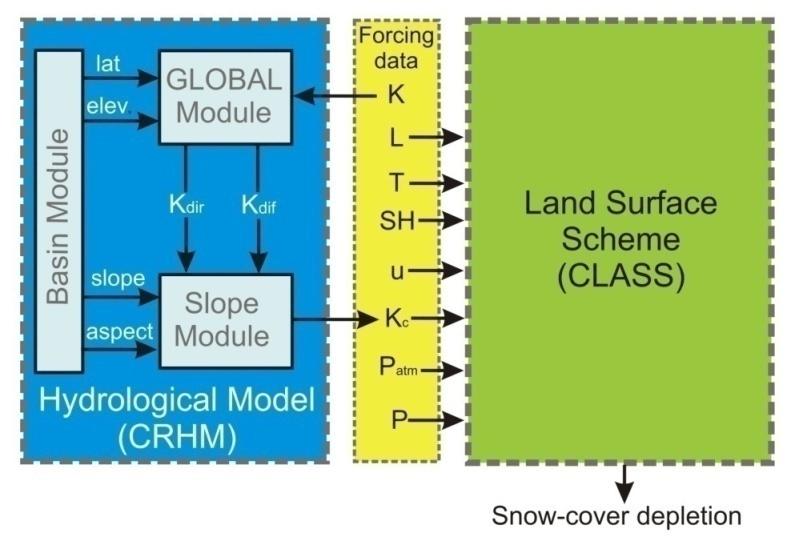
Effects of Spatial Aggregation of Initial Conditions and Forcing Data on Modeling Snowmelt Using a Land Surface Scheme
 AUGUST 2008 D O R N E S E T A L. 789 Effects of Spatial Aggregation of Initial Conditions and Forcing Data on Modeling Snowmelt Using a Land Surface Scheme PABLO F. DORNES AND JOHN W. POMEROY Centre for
Impacts of snowpack accumulation and summer weather on alpine glacier hydrology
 Impacts of snowpack accumulation and summer weather on alpine glacier hydrology Caroline Aubry-Wake, Dhiraj Pradhananga, John W. Pomeroy GEWEX 8 th Open Science Meeting, Canmore AB, May 3-11 2018 Canadian
APPLICATION OF AN ARCTIC BLOWING SNOW MODEL
 APPLICATION OF AN ARCTIC BLOWING SNOW MODEL J.W. Pomero l, P. ~arsh' and D.M. Gray2 -Hydrology Research Institute Saskatoon, Saskatchewan, Canada S7N 3H5 '~ivision of Hydrology, University of Saskatchewan
P. Marsh and J. Pomeroy National Hydrology Research Institute 11 Innovation Blvd., Saskatoon, Sask. S7N 3H5
 WATER AND ENERGY FLUXES DURING THE SNOWMELT PERIOD AT AN ARCTIC TREELINE SITE P. Marsh and J. Pomeroy National Hydrology Research Institute 11 Innovation Blvd., Saskatoon, Sask. S7N 3H5 marshp@nhrisv.nhrc.skdoe.ca
Lecture 8: Snow Hydrology
 GEOG415 Lecture 8: Snow Hydrology 8-1 Snow as water resource Snowfall on the mountain ranges is an important source of water in rivers. monthly pcp (mm) 100 50 0 Calgary L. Louise 1 2 3 4 5 6 7 8 9 10
S. R. FASSNACHT. Watershed Science, Colorado State University, Fort Collins, Colorado Z.-L. YANG
 298 J O U R N A L O F H Y D R O M E T E O R O L O G Y VOLUME 7 Effects of Averaging and Separating Soil Moisture and Temperature in the Presence of Snow Cover in a SVAT and Hydrological Model for a Southern
Using the MESH modelling system for hydrological ensemble forecasting of the Laurentian Great Lakes at the regional scale
 Using the MESH modelling system for hydrological ensemble forecasting of the Laurentian Great Lakes at the regional scale Alain Pietroniro 1, Vincent Fortin 2, Nicholas Kouwen 3, Champa Neal 4, Richard
ECCC/CCMEP variable resolution modelling of the Hudson Bay watershed
 ECCC/CCMEP variable resolution modelling of the Hudson Bay watershed Vincent Fortin (and many collaborators) Division de la recherche en météorologie Environnement en Changement climatique Canada GEM-based
Daytime long-wave radiation approximation for physical hydrological modelling of snowmelt: a case study of southwestern Ontario
 Soil-Vegetation-Atmosphere Transfer Schemes and Large-Scale Hydrological Models (Proceedings of a symposium held during tile Sixth I AI IS Scientific Assembly at Maastricht, The Netherlands. July 2001).
1.5 Biome-scale Representation of Snow Cover Development and Ablation in Boreal and Tundra Ecosystems
 1.5 Biome-scale Representation of Snow Cover Development and Ablation in Boreal and Tundra Ecosystems John Pomeroy 1 (presenter), Don Gray 2, Raoul Granger 3, Phil Marsh 3, Newell Hedstrom 3, Richard Janowicz
Parameterizing redistribution and sublimation of blowing snow for hydrological models: tests in a mountainous subarctic catchment
 HYDROLOGICAL PROCESSES Hydrol. Process. 23, 2570 2583 (2009) Published online 6 July 2009 in Wiley InterScience (www.interscience.wiley.com).7356 Parameterizing redistribution and sublimation of blowing
2.3 Parameterization of Evapotranspiration Using Remotely-Sensed Data
 2.3 Parameterization of Evapotranspiration Using Remotely-Sensed Data Raoul Granger 1 (presenter), John Pomeroy 1,2, Normand Bussières 3, Ric Janowicz 4 1 National Water Research Institute, National Hydrology
Regional offline land surface simulations over eastern Canada using CLASS. Diana Verseghy Climate Research Division Environment Canada
 Regional offline land surface simulations over eastern Canada using CLASS Diana Verseghy Climate Research Division Environment Canada The Canadian Land Surface Scheme (CLASS) Originally developed for the
Tropics & Sub-Tropics. How can predictive approaches be improved: Data Sparse Situations
 Tropics & Sub-Tropics How can predictive approaches be improved: Data Sparse Situations 1. Protocol for catchment function diagnostics and model setup. Use of a decision tree as a preliminary stage to
Development of the MESH modelling system for hydrological ensemble forecasting of the Laurentian Great Lakes at the regional scale
 Hydrol. Earth Syst. Sci., 11, 1279 1294, 2007 Author(s) 2007. This work is licensed under a Creative Commons License. Hydrology and Earth System Sciences Development of the MESH modelling system for hydrological
Modelling blowing snow redistribution to prairie wetlands
 HYDROLOGICAL PROCESSES Hydrol. Process. (2009) Published online in Wiley InterScience (www.interscience.wiley.com).7348 Modelling blowing snow redistribution to prairie wetlands X. Fang* and J. W. Pomeroy
Terrestrial Snow Cover: Properties, Trends, and Feedbacks. Chris Derksen Climate Research Division, ECCC
 Terrestrial Snow Cover: Properties, Trends, and Feedbacks Chris Derksen Climate Research Division, ECCC Outline Three Snow Lectures: 1. Why you should care about snow: Snow and the cryosphere Classes of
National Framework for Glacier Monitoring & Assessment National-scale Reference :
 National Framework for Glacier Monitoring & Assessment National-scale Reference : Western & Northern Cordillera High Arctic (Queen Elizabeth Islands) Low Arctic (Baffin Island) emphasis on long time series
Canadian Prairie Snow Cover Variability
 Canadian Prairie Snow Cover Variability Chris Derksen, Ross Brown, Murray MacKay, Anne Walker Climate Research Division Environment Canada Ongoing Activities: Snow Cover Variability and Links to Atmospheric
Status report on the Great Lakes Runoff Inter-comparison Project for Lake Erie (GRIP-E)
") Status report on the Great Lakes Runoff Inter-comparison Project for Lake Erie (GRIP-E) Juliane Mai, Bryan A. Tolson, Hongren Shen, E tienne Gaborit, Nicolas Gasset, Vincent Fortin, Maria Abrahamowicz,
Status report on the Great Lakes Runoff Inter-comparison Project for Lake Erie (GRIP-E) Juliane Mai, Bryan A. Tolson, Hongren Shen, E tienne Gaborit, Nicolas Gasset, Vincent Fortin, Maria Abrahamowicz,
Lake Tahoe Watershed Model. Lessons Learned through the Model Development Process
 Lake Tahoe Watershed Model Lessons Learned through the Model Development Process Presentation Outline Discussion of Project Objectives Model Configuration/Special Considerations Data and Research Integration
SNOW AND GLACIER HYDROLOGY
 SNOW AND GLACIER HYDROLOGY by PRATAP SINGH National Institute of Hydrology, Roorkee, India and VIJAY P. SINGH Department of Civil and Environmental Engineering, Louisiana State University, Baton Rouge,
Development of the Canadian Precipitation Analysis (CaPA) and the Canadian Land Data Assimilation System (CaLDAS)
 and the Canadian Land Data Assimilation System (CaLDAS)") Development of the Canadian Precipitation Analysis (CaPA) and the Canadian Land Data Assimilation System (CaLDAS) Marco L. Carrera, Vincent Fortin and Stéphane Bélair Meteorological Research Division Environment
Development of the Canadian Precipitation Analysis (CaPA) and the Canadian Land Data Assimilation System (CaLDAS) Marco L. Carrera, Vincent Fortin and Stéphane Bélair Meteorological Research Division Environment
Snowmelt runoff sensitivity analysis to drought on the Canadian prairies
 HYDROLOGICAL PROCESSES Hydrol. Process. 21, 2594 2609 (2007) Published online in Wiley InterScience (www.interscience.wiley.com).6796 Snowmelt runoff sensitivity analysis to drought on the Canadian prairies
MARMOT CREEK BASIN: MANAGING FORESTS FOR WATER
 MARMOT CREEK BASIN: MANAGING FORESTS FOR WATER CABIN AND TWIN CREEK EXPERIMENTS 1962-1987 MARMOT CREEK SUBBASINS Subbasin Drainage Treatment Area (ha) (completion date) Cabin Creek 212 (50%)* Commercial
The Canadian Precipitation Analysis (CaPA) and the Canadian Land Data Assimilation System (CaLDAS)
 and the Canadian Land Data Assimilation System (CaLDAS)") The Canadian Precipitation Analysis (CaPA) and the Canadian Land Data Assimilation System (CaLDAS) Vincent Fortin (and many collaborators) Division de la recherche en météorologie Environnement en Changement
The Canadian Precipitation Analysis (CaPA) and the Canadian Land Data Assimilation System (CaLDAS) Vincent Fortin (and many collaborators) Division de la recherche en météorologie Environnement en Changement
Factors influencing spring and summer areal snow ablation and snowcover depletion in alpine terrain: detailed measurements from the Canadian Rockies
 Hydrol. Earth Syst. Sci. Discuss., https://doi.org/0./hess-0- Discussion started: May 0 c Author(s) 0. CC BY.0 License. Factors influencing spring and summer areal snow ablation and snowcover depletion
Hydrological Modeling of the Upper South Saskatchewan River Basin: Multi-basin Calibration and Gauge De-clustering Analysis
 Hydrological Modeling of the Upper South Saskatchewan River Basin: Multi-basin Calibration and Gauge De-clustering Analysis by Cameron Dunning A thesis presented to the University of Waterloo in fulfillment
ESTIMATING SNOWMELT CONTRIBUTION FROM THE GANGOTRI GLACIER CATCHMENT INTO THE BHAGIRATHI RIVER, INDIA ABSTRACT INTRODUCTION
 ESTIMATING SNOWMELT CONTRIBUTION FROM THE GANGOTRI GLACIER CATCHMENT INTO THE BHAGIRATHI RIVER, INDIA Rodney M. Chai 1, Leigh A. Stearns 2, C. J. van der Veen 1 ABSTRACT The Bhagirathi River emerges from
Geog Lecture 19
 Geog 1000 - Lecture 19 Fluvial Geomorphology and River Systems http://scholar.ulethbridge.ca/chasmer/classes/ Today s Lecture (Pgs 346 355) 1. What is Fluvial Geomorphology? 2. Hydrology and the Water
Inter-linkage case study in Pakistan
 7 th GEOSS Asia Pacific Symposium GEOSS AWCI Parallel Session: 26-28 May, 2014, Tokyo, Japan Inter-linkage case study in Pakistan Snow and glaciermelt runoff modeling in Upper Indus Basin of Pakistan Maheswor
A WATER CYCLE PREDICTION SYSTEM
 A WATER CYCLE PREDICTION SYSTEM FOR THE GREAT LAKES AND ST. LAWRENCE RIVER V. Fortin 1, D. Durnford 2, G. Smith 1, P. Matte 1, M. Mackay 1, N. Bernier 1... and many others 1 Meteorological Research Division,
Radar precipitation for winter hydrological modelling
 Weather Radar Information and Distributed Hydrological Modelling (Proceedings of symposium IIS03 held during IUOG2003 al Sapporo. July 2003). IAHS Publ. no. 282. 2003. 35 Radar precipitation for winter
Appendix D. Model Setup, Calibration, and Validation
 . Model Setup, Calibration, and Validation Lower Grand River Watershed TMDL January 1 1. Model Selection and Setup The Loading Simulation Program in C++ (LSPC) was selected to address the modeling needs
Drought Monitoring with Hydrological Modelling
 st Joint EARS/JRC International Drought Workshop, Ljubljana,.-5. September 009 Drought Monitoring with Hydrological Modelling Stefan Niemeyer IES - Institute for Environment and Sustainability Ispra -
Small-Scale Spatial Variability of Radiant Energy for Snowmelt in a Mid-Latitude Sub-Alpine Forest
 59th EASTERN SNOW CONFERENCE Stowe, Vermont USA 22 Small-Scale Spatial Variability of Radiant Energy for Snowmelt in a Mid-Latitude Sub-Alpine Forest ALED ROWLANDS 1, JOHN POMEROY 1, JANET HARDY 2, DANNY
Water Availability in the South Saskatchewan River Basin under Climate Change
 Water Availability in the South Saskatchewan River Basin under Climate Change Dr. Alain Pietroniro, P.Eng. Ms. Brenda Toth, MSc Ms. Jessika Toyra National Water Research Institute, National Hydrology research
Hillslope Hydrology Q 1 Q Understand hillslope runoff processes. 2. Understand the contribution of groundwater to storm runoff.
 Objectives Hillslope Hydrology Streams are the conduits of the surface and subsurface runoff generated in watersheds. SW-GW interaction needs to be understood from the watershed perspective. During a storm
APPLICATIONS OF DOWNSCALING: HYDROLOGY AND WATER RESOURCES EXAMPLES
 APPLICATIONS OF DOWNSCALING: HYDROLOGY AND WATER RESOURCES EXAMPLES Dennis P. Lettenmaier Department of Civil and Environmental Engineering For presentation at Workshop on Regional Climate Research NCAR
Water Quality and Water Quantity: Two sides of the Same Coin. Chris Jones
 Water Quality and Water Quantity: Two sides of the Same Coin Chris Jones Unit of the College of Engineering Director: Larry Weber 90 Graduate Students from 16 countries 61 Research Engineers and Scientists
VIC Hydrology Model Training Workshop Part II: Building a model
 VIC Hydrology Model Training Workshop Part II: Building a model 11-12 Oct 2011 Centro de Cambio Global Pontificia Universidad Católica de Chile Ed Maurer Civil Engineering Department Santa Clara University
Soil Moisture Prediction and Assimilation
 Soil Moisture Prediction and Assimilation Analysis and Prediction in Agricultural Landscapes Saskatoon, June 19-20, 2007 STEPHANE BELAIR Meteorological Research Division Prediction and Assimilation Atmospheric
A SURVEY OF HYDROCLIMATE, FLOODING, AND RUNOFF IN THE RED RIVER BASIN PRIOR TO 1870
 A SURVEY OF HYDROCLIMATE, FLOODING, AND RUNOFF IN THE RED RIVER BASIN PRIOR TO 1870 W. F. RANNIE (UNIVERSITY OF WINNIPEG) Prepared for the Geological Survey of Canada September, 1998 TABLE OF CONTENTS
Using MODIS imagery to validate the spatial representation of snow cover extent obtained from SWAT in a data-scarce Chilean Andean watershed
 Using MODIS imagery to validate the spatial representation of snow cover extent obtained from SWAT in a data-scarce Chilean Andean watershed Alejandra Stehr 1, Oscar Link 2, Mauricio Aguayo 1 1 Centro
Supplement of Carbon stocks and fluxes in the high latitudes: using site-level data to evaluate Earth system models
 Supplement of Biogeosciences, 14, 5143 5169, 2017 https://doi.org/10.5194/bg-14-5143-2017-supplement Author(s) 2017. This work is distributed under the Creative Commons Attribution 3.0 License. Supplement
2 Development of a Physically Based Hydrologic Model of the Upper Cosumnes Basin
 2 Development of a Physically Based Hydrologic Model of the Upper Cosumnes Basin 2.1 Introduction The physically based watershed hydrologic model, WEHY (watershed environmental hydrology) model (Kavvas
Snow Melt with the Land Climate Boundary Condition
 Snow Melt with the Land Climate Boundary Condition GEO-SLOPE International Ltd. www.geo-slope.com 1200, 700-6th Ave SW, Calgary, AB, Canada T2P 0T8 Main: +1 403 269 2002 Fax: +1 888 463 2239 Introduction
Why modelling? Glacier mass balance modelling
 Why modelling? Glacier mass balance modelling GEO 4420 Glaciology 12.10.2006 Thomas V. Schuler t.v.schuler@geo.uio.no global mean temperature Background Glaciers have retreated world-wide during the last
The National Operational Hydrologic Remote Sensing Center Operational Snow Analysis
 The National Operational Hydrologic Remote Sensing Center Operational Snow Analysis World Meteorological Organization Global Cryosphere Watch Snow-Watch Workshop Session 3: Snow Analysis Products Andrew
Snow II: Snowmelt and energy balance
 Snow II: Snowmelt and energy balance The are three basic snowmelt phases 1) Warming phase: Absorbed energy raises the average snowpack temperature to a point at which the snowpack is isothermal (no vertical
HYDROLOGICAL MODELING OF HIGHLY GLACIERIZED RIVER BASINS. Nina Omani, Raghavan Srinivasan, Patricia Smith, Raghupathy Karthikeyan, Gerald North
 HYDROLOGICAL MODELING OF HIGHLY GLACIERIZED RIVER BASINS Nina Omani, Raghavan Srinivasan, Patricia Smith, Raghupathy Karthikeyan, Gerald North Problem statement Glaciers help to keep the earth cool High
Boundary-layer integration approach to advection of sensible heat to a patchy snow cover
 HYDROLOGICAL PROCESSES Hydrol. Process. 16, 3559 3569 (2002) Published online in Wiley InterScience (www.interscience.wiley.com). DOI: 10.1002/hyp.1227 Boundary-layer integration approach to advection
Quantitative Flood Forecasts using Short-term Radar Nowcasting
 Quantitative Flood Forecasts using Short-term Radar Nowcasting Enrique R. Vivoni *, Dara Entekhabi *, Rafael L. Bras *, Matthew P. Van Horne *, Valeri Y. Ivanov *, Chris Grassotti + and Ross Hoffman +
A distributed model of blowing snow over complex terrain
 HYDROLOGICAL PROCESSES Hydrol. Process. 13, 2423±2438 (1999) A distributed model of blowing snow over complex terrain Richard Essery, 1 Long Li 1 and John Pomeroy 2 * 1 Division of Hydrology, University
DEVELOPMENT AND APPLICATION OF A HYDROCLIMATOLOGICAL STREAM TEMPERATURE MODEL WITHIN SWAT
 DEVELOPMENT AND APPLICATION OF A HYDROCLIMATOLOGICAL STREAM TEMPERATURE MODEL WITHIN SWAT Darren L. Ficklin 1, Yuzhou Luo 2, Iris T. Stewart 1, Edwin P. Maurer 3 1 Environmental Studies Institute, Santa
Snow, Snowpacks and Runoff. David G Tarboton Charles H Luce
 Snow, Snowpacks and Runoff David G Tarboton Charles H Luce Show and Tell Images from http://www.anri.barc.usda.gov/emusnow/default.htm Potential effects of climate change on snow Advance in snowmelt timing
International Snow Science Workshop
 Wind Effect on Snow Over Arctic Sea-ice: Evaluation of a Sea-ice / Snow / Blowing Snow Model Yi-Ching Chung *, Stéphane Bélair, and Jocelyn Mailhot Numerical Prediction Research Section, Meteorological
Snowmelt runoff from northern alpine tundra hillslopes: major processes and methods of simulation
 Snowmelt runoff from northern alpine tundra hillslopes: major processes and methods of simulation W. L. Quinton, S. K. Carey, N. T. Goeller To cite this version: W. L. Quinton, S. K. Carey, N. T. Goeller.
Supplementary Materials for
 advances.sciencemag.org/cgi/content/full/3/12/e1701169/dc1 Supplementary Materials for Abrupt shift in the observed runoff from the southwestern Greenland ice sheet Andreas P. Ahlstrøm, Dorthe Petersen,
Evaluation of Snowpack Simulations over the Canadian Rockies with an Experimental Hydrometeorological Modeling System
 OCTOBER 2010 C A R R E R A E T A L. 1123 Evaluation of Snowpack Simulations over the Canadian Rockies with an Experimental Hydrometeorological Modeling System MARCO L. CARRERA, STÉPHANE BÉLAIR, VINCENT
 Permafrost http://www.cbc.ca/news/canada/story/2011/11/16/north-bigfix-permafrost.html 1. What is permafrost? Permafrost is a thick layer of permanently frozen ground. 2. Large parts of northeastern Russia
Snow and glacier change modelling in the French Alps
 International Network for Alpine Research Catchment Hydrology Inaugural Workshop Barrier Lake Field Station, Kananaskis Country, Alberta, Canada 22-24 October 2015 Snow and glacier change modelling in
Overview on the modelling setup Seven new features in the modelling framework First results for the Alpine Rhine and Engadin Conclusions and Outlook
 SUB PROJECT: Natural water balance of Switzerland and its most important large river basins Overview on the modelling setup Seven new features in the modelling framework First results for the Alpine Rhine
Laboratory Exercise #3 The Hydrologic Cycle and Running Water Processes
 Laboratory Exercise #3 The Hydrologic Cycle and Running Water Processes page - 1 Section A - The Hydrologic Cycle Figure 1 illustrates the hydrologic cycle which quantifies how water is cycled throughout
RAL Advances in Land Surface Modeling Part I. Andrea Hahmann
 RAL Advances in Land Surface Modeling Part I Andrea Hahmann Outline The ATEC real-time high-resolution land data assimilation (HRLDAS) system - Fei Chen, Kevin Manning, and Yubao Liu (RAL) The fine-mesh
Surface Processes Focus on Mass Wasting (Chapter 10)
") Surface Processes Focus on Mass Wasting (Chapter 10) 1. What is the distinction between weathering, mass wasting, and erosion? 2. What is the controlling force in mass wasting? What force provides resistance?
Surface Processes Focus on Mass Wasting (Chapter 10) 1. What is the distinction between weathering, mass wasting, and erosion? 2. What is the controlling force in mass wasting? What force provides resistance?
Interaction of North American Land Data Assimilation System and National Soil Moisture Network: Soil Products and Beyond
 Interaction of North American Land Data Assimilation System and National Soil Moisture Network: Soil Products and Beyond Youlong Xia 1,2, Michael B. Ek 1, Yihua Wu 1,2, Christa Peters-Lidard 3, David M.
MODULE 7 LECTURE NOTES 5 DRAINAGE PATTERN AND CATCHMENT AREA DELINEATION
 MODULE 7 LECTURE NOTES 5 DRAINAGE PATTERN AND CATCHMENT AREA DELINEATION 1. Introduction Topography of the river basin plays an important role in hydrologic modelling, by providing information on different
Effects of forest cover and environmental variables on snow accumulation and melt
 Effects of forest cover and environmental variables on snow accumulation and melt Mariana Dobre, William J. Elliot, Joan Q. Wu, Timothy E. Link, Ina S. Miller Abstract The goal of this study was to assess
Operational Perspectives on Hydrologic Model Data Assimilation
 Operational Perspectives on Hydrologic Model Data Assimilation Rob Hartman Hydrologist in Charge NOAA / National Weather Service California-Nevada River Forecast Center Sacramento, CA USA Outline Operational
Winter Precipitation, Sublimation, and Snow-Depth in the Pan-Arctic: Critical Processes and a Half Century of Change
 Winter Precipitation, Sublimation, and Snow-Depth in the Pan-Arctic: Critical Processes and a Half Century of Change PI s: Glen E. Liston, Colorado State University Larry J. Mahrt, Oregon State University
Lecture 3A: Interception
 3-1 GEOG415 Lecture 3A: Interception What is interception? Canopy interception (C) Litter interception (L) Interception ( I = C + L ) Precipitation (P) Throughfall (T) Stemflow (S) Net precipitation (R)
Fresh Water: Streams, Lakes Groundwater & Wetlands
 Fresh Water:, Lakes Groundwater & Wetlands Oct 27 Glaciers and Ice Ages Chp 13 Nov 3 Deserts and Wind and EXAM #3 Slope hydrologic cycle P = precip I = precip intercepted by veg ET = evapotranspiration
Research highlights from permafrost research: Rock glacier mapping in the HKH region with Google Earth
 Research highlights from permafrost research: Rock glacier mapping in the HKH region with Google Earth M.-O. Schmid, P. Baral, S. Gruber, S. Shahi, T. Shrestha, D. Stumm, and P. Wester International Centre
Snow Hydrology of Canadian Prairie Droughts: Model Development and Application
 Snow Hydrology of Canadian Prairie Droughts: Model Development and Application A Thesis Submitted to the College of Graduate Studies and Research in Partial Fulfillment of the Requirements for the Degree
Global Water Cycle. Surface (ocean and land): source of water vapor to the atmosphere. Net Water Vapour Flux Transport 40.
: source of water vapor to the atmosphere. Net Water Vapour Flux Transport 40.") Global Water Cycle Surface (ocean and land): source of water vapor to the atmosphere Water Vapour over Land 3 Net Water Vapour Flux Transport 40 Water Vapour over Sea 10 Glaciers and Snow 24,064 Permafrost
Global Water Cycle Surface (ocean and land): source of water vapor to the atmosphere Water Vapour over Land 3 Net Water Vapour Flux Transport 40 Water Vapour over Sea 10 Glaciers and Snow 24,064 Permafrost
W.L. Quinton, S.K. Carey and N.T. Goeller
 Hydrology and Earth System Snowmelt Sciences, runoff 8(5), from 877 890 northern (2004) alpine tundra EGU hillslopes: major processes and methods of simulation Snowmelt runoff from northern alpine tundra
ES 105 Surface Processes I. Hydrologic cycle A. Distribution % in oceans 2. >3% surface water a. +99% surface water in glaciers b.
 ES 105 Surface Processes I. Hydrologic cycle A. Distribution 1. +97% in oceans 2. >3% surface water a. +99% surface water in glaciers b. >1/3% liquid, fresh water in streams and lakes~1/10,000 of water
Error Propagation from Radar Rainfall Nowcasting Fields to a Fully-Distributed Flood Forecasting Model
 Error Propagation from Radar Rainfall Nowcasting Fields to a Fully-Distributed Flood Forecasting Model Enrique R. Vivoni 1, Dara Entekhabi 2 and Ross N. Hoffman 3 1. Department of Earth and Environmental
Remote Sensing of SWE in Canada
 Remote Sensing of SWE in Canada Anne Walker Climate Research Division, Environment Canada Polar Snowfall Hydrology Mission Workshop, June 26-28, 2007 Satellite Remote Sensing Snow Cover Optical -- Snow
Overview of fluvial and geotechnical processes for TMDL assessment
 Overview of fluvial and geotechnical processes for TMDL assessment Christian F Lenhart, Assistant Prof, MSU Research Assoc., U of M Biosystems Engineering Fluvial processes in a glaciated landscape Martin
THE ROLE OF MICROSTRUCTURE IN FORWARD MODELING AND DATA ASSIMILATION SCHEMES: A CASE STUDY IN THE KERN RIVER, SIERRA NEVADA, USA
 MICHAEL DURAND (DURAND.8@OSU.EDU), DONGYUE LI, STEVE MARGULIS Photo: Danielle Perrot THE ROLE OF MICROSTRUCTURE IN FORWARD MODELING AND DATA ASSIMILATION SCHEMES: A CASE STUDY IN THE KERN RIVER, SIERRA
The Community Noah LSM with Multi-physics Options
 The Community Noah LSM with Multi-physics Options Guo-Yue Niu Collaborators: ZL Yang, KE Mitchell, F Chen, MB Ek, M. Barlage, L. Longuevergne, A Kumar, K Manning, D Niyogi, E Rosero, M Tewari, and Y. Xia
Components of the Climate System. Lecture 2: Earth s Climate System. Pop Quiz. Sub-components Global cycles What comes in What goes out
 Lecture 2: Earth s Climate System Components of the Climate System terrestrial radiation Atmosphere Ocean solar radiation Land Energy, Water, and Biogeochemistry Cycles Sub-components Global cycles What
Shrub tundra snowmelt
 HYDROLOGICAL PROCESSES Hydrol. Process. 2, 923 941 (26) Published online in Wiley InterScience (www.interscience.wiley.com). DOI: 1.12/hyp.6124 Shrub tundra snowmelt J. W. Pomeroy, 1 *D.S.Bewley, 2 R.
SIMULATION OF ENERGY AND WATER BUDGETS IN ASPEN, BLACK SPRUCE AND JACK PINE FORESTS DURING WINTER USING THE CANADIAN LAND SURFACE SCHEME
 P1.28 IMULATION OF ENERGY AND WATER BUDGET IN APEN, BLACK PRUCE AND JACK PINE FORET DURING WINTER UING THE CANADIAN LAND URFACE CHEME Paul A. Bartlett*, Murray D. MacKay and Diana L. Verseghy Climate Research
Lecture 2: Earth s Climate System
 Lecture 2: Earth s Climate System terrestrial radiation solar radiation Atmosphere Ocean Solid Earth Land Energy, Water, and Biogeochemistry Cycles Sub-components Global cycles What comes in What goes
The Hydrologic Cycle
 The Hydrologic Cycle Monthly precipitation for the central Arctic Ocean based on data from the Russian North Pole manned camps with daily bias adjustments. Raw precipitation totals are shown along with
Hydrometeorological data from Marmot Creek Research Basin, Canadian Rockies
 Earth Syst. Sci. Discuss., https://doi.org/.194/essd-18-117 Manuscript under review for journal Earth Syst. Sci. Hydrometeorological data from Marmot Creek Research Basin, Canadian Rockies Xing Fang 1,
GLACIER AND SNOWMELT MODELLING USING SWAT: GANGA BASIN CASE STUDY. INRM Consultants Pvt. Ltd.
 GLACIER AND SNOWMELT MODELLING USING SWAT: GANGA BASIN CASE STUDY INRM Consultants Pvt. Ltd. Introduction Snowmelt Runoff contribution in the Himalayan Rivers Estimation of Average contribution of Snowmelt
Spatially-Distributed Simulation of the Snowpack within the GSSHA Hydrologic Model for Areas with Limited Data
 Spatially-Distributed Simulation of the Snowpack within the GSSHA Hydrologic Model for Areas with Limited Data 2016 AWRA Specialty Conference Sacramento, CA 13 July 2016 Michael L. Follum*, Charles W.
Open Source ENKI: Dynamic Environmental Model Framework. A possible pre-processor for WRF-Hydro?
 Open Source ENKI: Dynamic Environmental Model Framework A possible pre-processor for WRF-Hydro? 1st European Fully Coupled AtmosphericHydrological Modeling and WRF-Hydro Users workshop. University of Calabria.
Grade 8 Science. Unit 1: Water Systems on Earth Chapter 1
 Grade 8 Science Unit 1: Water Systems on Earth Chapter 1 Effects of Water? Churchill River Large Ocean Wave How do you use water? House Hold Use Personal Use Recreational Activities Water Distribution