The National Operational Hydrologic Remote Sensing Center Operational Snow Analysis
|
|
|
- Corey Randall
- 5 years ago
- Views:
Transcription


1 The National Operational Hydrologic Remote Sensing Center Operational Snow Analysis World Meteorological Organization Global Cryosphere Watch Snow-Watch Workshop Session 3: Snow Analysis Products Andrew Rost NOHRSC Director
2 The NOHRSC Mission To support a Weather-Ready Nation by producing the best possible estimate of snow water equivalent using all available data including atmospheric model state variables, satellite imagery, airborne measurements, and ground observations

3 The NOHRSC Mission employing state-of-the-art operational snow, land surface modeling, and data assimilation
4 Outline Snow modeling and data assimilation for the coterminous United States Land surface modeling and data assimilation for Alaska Land surface modeling for Central Asia Future land surface modeling and data assimilation plans for North America Gaps, issues, and potential contributions
, southern Canada (54N), 30 arc second resolution on lat/lon grid Hourly time steps, four 6-hour model cycles,")
5 Snow Modeling and Data Assimilation for the Coterminous United States 2003: Transitioned from linear detrending spatial interpolation model to energy and mass balanced fullphysics snow model Simplified SNOTHERM and Prairie Blowing Snow models Domain: Coterminous US (8M sq km), southern Canada (54N), 30 arc second resolution on lat/lon grid Hourly time steps, four 6-hour model cycles, daily data assimilation (where and when required), no update (reanalysis) period 72-hour forecasts; first 24 hours driven by Rapid Refresh; next 48 hours North America Model


6 Snow Modeling and Data Assimilation for the Coterminous United States Forcings Snow and non-snow precipitation Air temperature Solar radiation Wind speed and direction Relative humidity Principle Model State Variables Snow water equivalent Snow density Snow depth Snow melt Snow sublimation Blowing snow Snow temperature Sensible and latent heat

7 Full-Physics Energy and Mass Balanced Snow Model Forced by down-scaled Rapid Refresh and North America Model numerical weather prediction model data Models mass and energy fluxes between the atmosphere, 3 snowpack layers, and 2 thermally active soil layers Runs on a modest cluster of of four 8-core servers


 The")


8 Assimilate All Available In Situ Observations (15M Observations / 37K Stations) The NOHRSC Operates a Real Time National Collective of Observation Collectives

9 Data Assimilation Only Where and When Needed Only Where Observed and Modeled Differences are Spatially Correlated Direct Insertion of 3D Spatially Interpolated Differences Surprising Agreement Between Observations and Modeled Snowpack States
10 6100 In Situ SWE Observation Sites

11 Potentially an Additional 610 In Situ SWE Observation Sites in Canada And the promise of more to come The NOHRSC collaborates closely with Federal, Provincial, and private Canadian data providers


12 Airborne Gamma Surveys Fills in situ observations gaps Partial emancipation from the representativeness of a point debate 10 miles long by 1,000 feet wide (2 square mile area)
13 Airborne Gamma Surveys Atmospheric Radon Cosmic Radiation Potassium, Uranium, and Thorium
14 2500 SWE Gamma Flight Lines And Growing
15 28000 In Situ Snow Depth Observation Sites Supplement in situ SWE observations Most SWE observation sites report infrequently Convert snow depth observations into SWE using modeled snowpack density


16 MODIS Fractional Snow Cover Run T Painter s MODSCAG and MOD09_SPA internally Identifies the edge of the snowpack Allows us to assimilate zero snow observations Constrains the areal extent of modeled snow pack states

17 Benefit Impact on River Forecasting Hydrographs are the grand integrator Evidence that assimilating in situ point observations do not have a negative on modeling RFC Forecast without NOHRSC Data RFC Forecast Updated with NOHRSC Data Simple Lumped Model SWE NOHRSC Modeled SWE Observed Stage Underestimated Forecast Stage Corrected Forecast Stage

18 NOHRSC Stakeholders National Weather Service Federal and State Agencies Private Sector Canadian 13 River Forecast Centers Weather Forecast Offices U.S. Army Corps of Engineers Bureau of Reclamation New York Department of Environmental Protection Natural Resources Conservation Service Department of Transportation Montana Department of Emergency Services San Francisco Public Utilities Commission University of Albany ASRC/CESTM University of Wisconsin Sea Grant Institute National Snow and Ice Data Center FEMA Baron Advanced Meteorological Systems, LLC Weather Channel Meteorlogix, Inc. Merrril Lynch Weather Decision Technologies, Inc. SnowStreet AccuWeather Snow Plow Operators Oppenheimer Campbell Soup Company Snowmobile outfitters Mountaineers General Public Manitoba Department of Natural Resources New Brunswick Department of Natural Resources Alberta Environment BC Hydro British Columbia Ministry of Environment Environment Canada Saint John River Basin Commission

19 PRODUCTS Hourly model time steps 1 km 2 Resolution 30 Hr Forecast (72 FY12) INTERNET Interactive Maps 3D Visualization e.g. Google Earth Time-series loops National/Regional Discussions Text summaries by watershed Point Queries DIRECT FEED Push or Pull Gridded Data Flat Binary or GIS-ready
 LSMs run in the NASA Land Information System modeling framework 9-year spin-up LSMs driven by GDAS initially, now by both NAM and biasadjusted GDAS; i.e. a 4-member ensemble.")
20 Land Surface Modeling and Data Assimilation for Alaska 2008: Explored operational LIS for AK Domain: 42 x 24 at 0.01 ; 10.1 x 10 6 grid cells (4.6 x 10 6 unmasked) LSMs: CLM 2.0, Noah (2.7.1, now 3.2) LSMs run in the NASA Land Information System modeling framework 9-year spin-up LSMs driven by GDAS initially, now by both NAM and biasadjusted GDAS; i.e. a 4-member ensemble. Primary collaboration with APRFC during spring snow melt. Monthly snow surveys offer data assimilation potential.

21 GDAS+CLM SWE, Advantages of Land Surface Models Models same snowpack states Also models additional water balance variables year round Soil moisture profiles Snow temperature profiles Evaporative fluxes Surface runoff
 on lat/lon grid One hour time step LSMs: CLM, Noah Driven by GDAS only Few quantitative surface snow observations; model states are evaluated via anomaly")
22 Land Surface Modeling for Central Asia 2009: USGS collaboration for FEWS NET Domain: 70 x 35 at 0.01 ; 24.5 x 10 6 grid cells (22.1 x 10 6 unmasked) on lat/lon grid One hour time step LSMs: CLM, Noah Driven by GDAS only Few quantitative surface snow observations; model states are evaluated via anomaly analysis based on eleven years of retrospective runs.
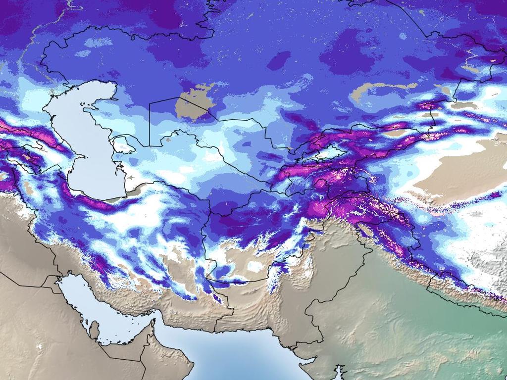
23 NOAH SWE

24 LIS at NOHRSC: Central Asia
 Domain: 116 x 55 at 0.008333 ; 91.9 x 10 6 grid cells (37.")
25 Future Land Surface Modeling and Data Assimilation Plans for North America October 2013: National Water Center Initial Operating Capacity ( IOC13 ) Domain: 116 x 55 at ; 91.9 x 10 6 grid cells (37.5 x 10 6 unmasked)
26 Future Land Surface Modeling and Data Assimilation Plans for North America October 2013: National Water Center Initial Operating Capacity ( IOC13 ) Domain: 116 x 55 at ; 91.9 x 10 6 grid cells (37.5 x 10 6 unmasked) LSMs: CLM, Noah Driven by Rapid Refresh and NAM Daily forecasts to 72 hours Hourly history files

27 Future Land Surface Modeling and Data Assimilation Plans for North America October 2014: IOC14 Possible capabilities beyond IOC13: Improved, AoR forcings 30-year reanalysis Update model cycles Snow data assimilation capabilities Additional land surface models Hydrologic routing
28 Gaps, Issues, and Potential Contributions Gaps Improved forcing data required, especially precipitation Better down scaling required (leverage climatology?) Data assimilation required, especially RADAR Improved (more and better) in situ observations required Issues Weather, climate, and hydrology needs differ e.g. atmospheric modelers may not be as concerned as hydrologists by snow under trees Potential contributions NOHRSC snow and land surface models and their IT infrastructure are scalable to global challenges at a reasonable cost Our initial North America effort is resourced with four 8-core Linux servers

29 Questions and Comments
Remote Sensing of SWE in Canada
 Remote Sensing of SWE in Canada Anne Walker Climate Research Division, Environment Canada Polar Snowfall Hydrology Mission Workshop, June 26-28, 2007 Satellite Remote Sensing Snow Cover Optical -- Snow
Operational Perspectives on Hydrologic Model Data Assimilation
 Operational Perspectives on Hydrologic Model Data Assimilation Rob Hartman Hydrologist in Charge NOAA / National Weather Service California-Nevada River Forecast Center Sacramento, CA USA Outline Operational
Operational Hydrologic Ensemble Forecasting. Rob Hartman Hydrologist in Charge NWS / California-Nevada River Forecast Center
 Operational Hydrologic Ensemble Forecasting Rob Hartman Hydrologist in Charge NWS / California-Nevada River Forecast Center Mission of NWS Hydrologic Services Program Provide river and flood forecasts
Folsom Dam Water Control Manual Update
 Folsom Dam Water Control Manual Update Public Workshop April 3, 2014 Location: Sterling Hotel Ballroom 1300 H Street, Sacramento US Army Corps of Engineers BUILDING STRONG WELCOME & INTRODUCTIONS 2 BUILDING
Canadian Prairie Snow Cover Variability
 Canadian Prairie Snow Cover Variability Chris Derksen, Ross Brown, Murray MacKay, Anne Walker Climate Research Division Environment Canada Ongoing Activities: Snow Cover Variability and Links to Atmospheric
Implementation of Land Information System in the NCEP Operational Climate Forecast System CFSv2. Jesse Meng, Michael Ek, Rongqian Yang, Helin Wei
 Implementation of Land Information System in the NCEP Operational Climate Forecast System CFSv2 Jesse Meng, Michael Ek, Rongqian Yang, Helin Wei 1 Outline NCEP CFSRR Land component CFSv1 vs CFSv2 Land
Land Data Assimilation at NCEP NLDAS Project Overview, ECMWF HEPEX 2004
 Dag.Lohmann@noaa.gov, Land Data Assimilation at NCEP NLDAS Project Overview, ECMWF HEPEX 2004 Land Data Assimilation at NCEP: Strategic Lessons Learned from the North American Land Data Assimilation System
Robert Shedd Northeast River Forecast Center National Weather Service Taunton, Massachusetts, USA
 Robert Shedd Northeast River Forecast Center National Weather Service Taunton, Massachusetts, USA Outline River Forecast Centers FEWS Implementation Status Forcing Data Ensemble Forecasting The Northeast
An investigation of sampling efficiency using historical data. Patrick Didier Advisor: Justine Blanford
 An investigation of sampling efficiency using historical data Patrick Didier Advisor: Justine Blanford Overview Introduction to Airborne Snow Survey program Goals of the Capstone Project Methods and Expected
Sample Density Analysis and Optimization Strategies for NOAA s Airborne Snow Water Equivalent Surveys
 Sample Density Analysis and Optimization Strategies for NOAA s Airborne Snow Water Equivalent Surveys Patrick Didier Penn State MGIS Program Advisor: Dr Justine Blanford Overview Introduction to the Snow
Interaction of North American Land Data Assimilation System and National Soil Moisture Network: Soil Products and Beyond
 Interaction of North American Land Data Assimilation System and National Soil Moisture Network: Soil Products and Beyond Youlong Xia 1,2, Michael B. Ek 1, Yihua Wu 1,2, Christa Peters-Lidard 3, David M.
Terrestrial Snow Cover: Properties, Trends, and Feedbacks. Chris Derksen Climate Research Division, ECCC
 Terrestrial Snow Cover: Properties, Trends, and Feedbacks Chris Derksen Climate Research Division, ECCC Outline Three Snow Lectures: 1. Why you should care about snow: Snow and the cryosphere Classes of
Snow Modeling and Observations at NOAA S National Operational Hydrologic Remote Sensing Center
 Snow Modeling and Observations at NOAA S National Operational Hydrologic Remote Sensing Center Thomas R. Carroll National Operational Hydrologic Remote Sensing Center, National Weather Service, National
Amita Mehta and Ana Prados
 Building Capacity in Utilizing NASA Remote Sensing Observations in SWAT for Water Resources and Agricultural Management Applications Amita Mehta and Ana Prados NASA - University of Maryland Baltimore County
An Overview of Operations at the West Gulf River Forecast Center Gregory Waller Service Coordination Hydrologist NWS - West Gulf River Forecast Center
 National Weather Service West Gulf River Forecast Center An Overview of Operations at the West Gulf River Forecast Center Gregory Waller Service Coordination Hydrologist NWS - West Gulf River Forecast
Rainfall-River Forecasting: Overview of NOAA s Role, Responsibilities, and Services
 Dr. Thomas Graziano Chief Hydrologic Services Division NWS Headquarters Steve Buan Service Coordination Hydrologist NWS North Central River Forecast Center Rainfall-River Forecasting: Overview of NOAA
Validation of satellite derived snow cover data records with surface networks and m ulti-dataset inter-comparisons
 Validation of satellite derived snow cover data records with surface networks and m ulti-dataset inter-comparisons Chris Derksen Climate Research Division Environment Canada Thanks to our data providers:
Modeling the Arctic Climate System
 Modeling the Arctic Climate System General model types Single-column models: Processes in a single column Land Surface Models (LSMs): Interactions between the land surface, atmosphere and underlying surface
The National Weather Service of the Future: Building a Weather-Ready Nation
 The of the Future: Building a Weather-Ready Nation Dr. Louis W. Uccellini Director, NOAA Assistant Administrator for Weather Services NCEP Production Suite Review December 2, 2014 Outline Building a Weather-Ready
NOAA s NATIONAL SNOW ANALYSES. Tom Carroll and Don Cline
 NOAA s NATIONAL SNOW ANALYSES Tom Carroll and Don Cline National Operational Hydrologic Remote Sensing Center National Weather Service, NOAA 1735 Lake Drive West, Chanhassen, Minnesota Phone: 952-361-6610
GLOBAL LAND DATA ASSIMILATION SYSTEM (GLDAS) PRODUCTS FROM NASA HYDROLOGY DATA AND INFORMATION SERVICES CENTER (HDISC) INTRODUCTION
 PRODUCTS FROM NASA HYDROLOGY DATA AND INFORMATION SERVICES CENTER (HDISC) INTRODUCTION") GLOBAL LAND DATA ASSIMILATION SYSTEM (GLDAS) PRODUCTS FROM NASA HYDROLOGY DATA AND INFORMATION SERVICES CENTER (HDISC) Hongliang Fang, Patricia L. Hrubiak, Hiroko Kato, Matthew Rodell, William L. Teng,
GLOBAL LAND DATA ASSIMILATION SYSTEM (GLDAS) PRODUCTS FROM NASA HYDROLOGY DATA AND INFORMATION SERVICES CENTER (HDISC) Hongliang Fang, Patricia L. Hrubiak, Hiroko Kato, Matthew Rodell, William L. Teng,
The Importance of Snowmelt Runoff Modeling for Sustainable Development and Disaster Prevention
 The Importance of Snowmelt Runoff Modeling for Sustainable Development and Disaster Prevention Muzafar Malikov Space Research Centre Academy of Sciences Republic of Uzbekistan Water H 2 O Gas - Water Vapor
Regional offline land surface simulations over eastern Canada using CLASS. Diana Verseghy Climate Research Division Environment Canada
 Regional offline land surface simulations over eastern Canada using CLASS Diana Verseghy Climate Research Division Environment Canada The Canadian Land Surface Scheme (CLASS) Originally developed for the
Development of the Canadian Precipitation Analysis (CaPA) and the Canadian Land Data Assimilation System (CaLDAS)
 and the Canadian Land Data Assimilation System (CaLDAS)") Development of the Canadian Precipitation Analysis (CaPA) and the Canadian Land Data Assimilation System (CaLDAS) Marco L. Carrera, Vincent Fortin and Stéphane Bélair Meteorological Research Division Environment
Development of the Canadian Precipitation Analysis (CaPA) and the Canadian Land Data Assimilation System (CaLDAS) Marco L. Carrera, Vincent Fortin and Stéphane Bélair Meteorological Research Division Environment
Assimilation of Snow and Ice Data (Incomplete list)
") Assimilation of Snow and Ice Data (Incomplete list) Snow/ice Sea ice motion (sat): experimental, climate model Sea ice extent (sat): operational, U.S. Navy PIPs model; Canada; others? Sea ice concentration
Assimilation of Snow and Ice Data (Incomplete list) Snow/ice Sea ice motion (sat): experimental, climate model Sea ice extent (sat): operational, U.S. Navy PIPs model; Canada; others? Sea ice concentration
Speakers: NWS Buffalo Dan Kelly and Sarah Jamison, NERFC Jeane Wallace. NWS Flood Services for the Black River Basin
 Speakers: NWS Buffalo Dan Kelly and Sarah Jamison, NERFC Jeane Wallace NWS Flood Services for the Black River Basin National Weather Service Who We Are The National Oceanic and Atmospheric Administration
Water Balance in the Murray-Darling Basin and the recent drought as modelled with WRF
 18 th World IMACS / MODSIM Congress, Cairns, Australia 13-17 July 2009 http://mssanz.org.au/modsim09 Water Balance in the Murray-Darling Basin and the recent drought as modelled with WRF Evans, J.P. Climate
Arkansas-Red Basin River Forecast Center Operations. RRVA Conference Durant, OK 8/22/2013 Jeff McMurphy Sr. Hydrologist - ABRFC
 Arkansas-Red Basin River Forecast Center Operations RRVA Conference Durant, OK 8/22/2013 Jeff McMurphy Sr. Hydrologist - ABRFC NWS River Forecast Centers NWS Weather Forecast Offices Operations Staffing
Missouri River Flood Task Force River Management Working Group Improving Accuracy of Runoff Forecasts
 Missouri River Flood Task Force River Management Working Group Improving Accuracy of Runoff Forecasts Kevin Grode, P.E. Reservoir Regulation Team Lead Missouri River Basin Water Management Northwestern
Flood Forecasting Tools for Ungauged Streams in Alberta: Status and Lessons from the Flood of 2013
 Flood Forecasting Tools for Ungauged Streams in Alberta: Status and Lessons from the Flood of 2013 John Pomeroy, Xing Fang, Kevin Shook, Tom Brown Centre for Hydrology, University of Saskatchewan, Saskatoon
Overview of Data for CREST Model
 Overview of Data for CREST Model Xianwu Xue April 2 nd 2012 CREST V2.0 CREST V2.0 Real-Time Mode Forcasting Mode Data Assimilation Precipitation PET DEM, FDR, FAC, Slope Observed Discharge a-priori parameter
Missouri River Basin Water Management Monthly Update
 Missouri River Basin Water Management Monthly Update Participating Agencies 255 255 255 237 237 237 0 0 0 217 217 217 163 163 163 200 200 200 131 132 122 239 65 53 80 119 27 National Oceanic and Atmospheric
Real-Time Meteorological Gridded Data: What s New With HEC-RAS
 Real-Time Meteorological Gridded Data: What s New With HEC-RAS Acquisition and Application of Gridded Meteorological Data in Support of the USACE s Real-Time Water Management Mission Fauwaz Hanbali, Tom
Missouri River Basin Water Management Monthly Update
 Missouri River Basin Water Management Monthly Update Participating Agencies 255 255 255 237 237 237 0 0 0 217 217 217 163 163 163 200 200 200 131 132 122 239 65 53 80 119 27 National Oceanic and Atmospheric
Great Lakes Information Network GIS (Queryable by topic, geography, organization, and upload date 73 layers as of October, 2009)
") Google Earth Files for the Great Lakes and Beyond GLOS Mapping Workshop Alpena, Michigan November 9, 2009 David Hart GIS Specialist University of Wisconsin Sea Grant Institute GREAT LAKES Great Lakes Information
Google Earth Files for the Great Lakes and Beyond GLOS Mapping Workshop Alpena, Michigan November 9, 2009 David Hart GIS Specialist University of Wisconsin Sea Grant Institute GREAT LAKES Great Lakes Information
National Weather Service. Harold H. Opitz Hydrologist in Charge
 National Weather Service Harold H. Opitz Hydrologist in Charge Goals Organization Role of the River Forecast Center Describe Forecast System & Tools Other Details NWS River Forecast Centers Northwest River
Land Surface Processes and Their Impact in Weather Forecasting
 Land Surface Processes and Their Impact in Weather Forecasting Andrea Hahmann NCAR/RAL with thanks to P. Dirmeyer (COLA) and R. Koster (NASA/GSFC) Forecasters Conference Summer 2005 Andrea Hahmann ATEC
Drought Monitoring with Hydrological Modelling
 st Joint EARS/JRC International Drought Workshop, Ljubljana,.-5. September 009 Drought Monitoring with Hydrological Modelling Stefan Niemeyer IES - Institute for Environment and Sustainability Ispra -
Hydrologic Forecast Centre Manitoba Infrastructure, Winnipeg, Manitoba. FEBRUARY OUTLOOK REPORT FOR MANITOBA February 23, 2018
 Page 1 of 17 Hydrologic Forecast Centre Manitoba Infrastructure, Winnipeg, Manitoba FEBRUARY OUTLOOK REPORT FOR MANITOBA February 23, 2018 Overview The February Outlook Report prepared by the Hydrologic
Land Analysis in the NOAA CFS Reanalysis. Michael Ek, Ken Mitchell, Jesse Meng Helin Wei, Rongqian Yang, and George Gayno
 Land Analysis in the NOAA CFS Reanalysis Michael Ek, Ken Mitchell, Jesse Meng Helin Wei, Rongqian Yang, and George Gayno 1 Outline CFS Reanalysis execution Land surface model upgrade from OSU to Noah LIS/GLDAS
Central Asia Regional Flash Flood Guidance System 4-6 October Hydrologic Research Center A Nonprofit, Public-Benefit Corporation
 http://www.hrcwater.org Central Asia Regional Flash Flood Guidance System 4-6 October 2016 Hydrologic Research Center A Nonprofit, Public-Benefit Corporation FFGS Snow Components Snow Accumulation and
2015 Fall Conditions Report
 2015 Fall Conditions Report Prepared by: Hydrologic Forecast Centre Date: December 21 st, 2015 Table of Contents Table of Figures... ii EXECUTIVE SUMMARY... 1 BACKGROUND... 2 SUMMER AND FALL PRECIPITATION...
Water Cycle Prediction on the Prairies
 Water Cycle Prediction on the Prairies A. Pietroniro, S. Marin, A. Liu, B. Davison, B. Toth, D. Shaw(AAFC), L. Martz Hydrometerology and Arctic Lab, Environment Canada, NHRC and Centre for Hydrology, University
Enhancing Weather Forecasts via Assimilating SMAP Soil Moisture and NRT GVF
 CICS Science Meeting, ESSIC, UMD, 2016 Enhancing Weather Forecasts via Assimilating SMAP Soil Moisture and NRT GVF Li Fang 1,2, Christopher Hain 1,2, Xiwu Zhan 2, Min Huang 1,2 Jifu Yin 1,2, Weizhong Zheng
ECCC/CCMEP variable resolution modelling of the Hudson Bay watershed
 ECCC/CCMEP variable resolution modelling of the Hudson Bay watershed Vincent Fortin (and many collaborators) Division de la recherche en météorologie Environnement en Changement climatique Canada GEM-based
NIDIS Intermountain West Drought Early Warning System January 15, 2019
 NIDIS Drought and Water Assessment NIDIS Intermountain West Drought Early Warning System January 15, 2019 Precipitation The images above use daily precipitation statistics from NWS COOP, CoCoRaHS, and
Sample Density Analysis and Optimization for NOAA's Airborne Snow Water Equivalent Surveys. Patrick D Didier
 Sample Density Analysis and Optimization for NOAA's Airborne Snow Water Equivalent Surveys Patrick D Didier Advisor: Justine Blanford Capstone Project Paper in Support of Master s in Geographic Information
Doug Kluck NOAA Kansas City, MO National Center for Environmental Information (NCEI) National Integrated Drought Information System (NIDIS)
 National Integrated Drought Information System (NIDIS)") National Integrated Drought Information System (NIDIS) for the Missouri River Basin Drought Early Warning Information System (DEWS) & Runoff Trends in the Missouri Basin & Latest Flood Outlook Doug Kluck
National Integrated Drought Information System (NIDIS) for the Missouri River Basin Drought Early Warning Information System (DEWS) & Runoff Trends in the Missouri Basin & Latest Flood Outlook Doug Kluck
NIDIS Intermountain West Regional Drought Early Warning System February 7, 2017
 NIDIS Drought and Water Assessment NIDIS Intermountain West Regional Drought Early Warning System February 7, 2017 Precipitation The images above use daily precipitation statistics from NWS COOP, CoCoRaHS,
Focus Areas. Colorado Rio Grande Jemez. San Pedro. An NSF Science and Technology Center SAHRA
 Focus Areas 1 San Pedro Colorado Rio Grande Jemez Geo-database Structure 2 SGB Schemas Upper Rio Grande Research Data Flux Tower Data Public Data Hydrology Rules, Users and Procedures Jemez River Colorado
Land Surface: Snow Emanuel Dutra
 Land Surface: Snow Emanuel Dutra emanuel.dutra@ecmwf.int Slide 1 Parameterizations training course 2015, Land-surface: Snow ECMWF Outline Snow in the climate system, an overview: Observations; Modeling;
NATIONAL WATER RESOURCES OUTLOOK
 NATIONAL WATER RESOURCES OUTLOOK American Meteorological Society Annual Meeting 24 th Hydrology Conference 9.2 James Noel Service Coordination Hydrologist National Weather Service-Ohio River Forecast Center
Quenching the Valley s thirst: The connection between Sierra Nevada snowpack & regional water supply
 Quenching the Valley s thirst: The connection between Sierra Nevada snowpack & regional water supply Roger Bales, UC Merced Snow conditions Snow & climate change Research directions Sierra Nevada snow
Evaluation of a MODIS Triangle-based Algorithm for Improving ET Estimates in the Northern Sierra Nevada Mountain Range
 Evaluation of a MODIS Triangle-based Algorithm for Improving ET Estimates in the Northern Sierra Nevada Mountain Range Kyle R. Knipper 1, Alicia M. Kinoshita 2, and Terri S. Hogue 1 January 5 th, 2015
USA National Weather Service Community Hydrologic Prediction System
 USA National Weather Service Community Hydrologic Prediction System Rob Hartman Hydrologist in Charge NOAA / National Weather Service California-Nevada River Forecast Center Sacramento, CA Background Outline
The Canadian Land Data Assimilation System (CaLDAS)
") The Canadian Land Data Assimilation System (CaLDAS) Marco L. Carrera, Stéphane Bélair, Bernard Bilodeau and Sheena Solomon Meteorological Research Division, Environment Canada Dorval, QC, Canada 2 nd Workshop
The Canadian Land Data Assimilation System (CaLDAS) Marco L. Carrera, Stéphane Bélair, Bernard Bilodeau and Sheena Solomon Meteorological Research Division, Environment Canada Dorval, QC, Canada 2 nd Workshop
The North American Drought Monitor - The Canadian Perspective -
 The North American Drought Monitor - The Canadian Perspective - Trevor Hadwen National Agroclimate Information Service AAFC-PFRA, Regina Canmore, Alberta March 16-18, 2008 Background The NADM is a cooperative
REVISION OF THE STATEMENT OF GUIDANCE FOR GLOBAL NUMERICAL WEATHER PREDICTION. (Submitted by Dr. J. Eyre)
") WORLD METEOROLOGICAL ORGANIZATION Distr.: RESTRICTED CBS/OPAG-IOS (ODRRGOS-5)/Doc.5, Add.5 (11.VI.2002) COMMISSION FOR BASIC SYSTEMS OPEN PROGRAMME AREA GROUP ON INTEGRATED OBSERVING SYSTEMS ITEM: 4 EXPERT
WORLD METEOROLOGICAL ORGANIZATION Distr.: RESTRICTED CBS/OPAG-IOS (ODRRGOS-5)/Doc.5, Add.5 (11.VI.2002) COMMISSION FOR BASIC SYSTEMS OPEN PROGRAMME AREA GROUP ON INTEGRATED OBSERVING SYSTEMS ITEM: 4 EXPERT
Using kilometric-resolution meteorological forecasts and satellite-derived incoming radiations for snowpack modelling in complex terrain
 Using kilometric-resolution meteorological forecasts and satellite-derived incoming radiations for snowpack modelling in complex terrain Louis Quéno, Vincent Vionnet, Fatima Karbou, Ingrid Dombrowski-Etchevers,
HyMet Company. Streamflow and Energy Generation Forecasting Model Columbia River Basin
 HyMet Company Streamflow and Energy Generation Forecasting Model Columbia River Basin HyMet Inc. Courthouse Square 19001 Vashon Hwy SW Suite 201 Vashon Island, WA 98070 Phone: 206-463-1610 Columbia River
The Delaware Environmental Monitoring & Analysis Center
 The Delaware Environmental Monitoring & Analysis Center Tina Callahan Delaware Estuary Science & Environmental Summit 2013 January 27-30, 2013 What is DEMAC? Delaware Environmental Monitoring & Analysis
Northrop Grumman Concept Paper
 Northrop Grumman Concept Paper A Comprehensive Geospatial Web-based Solution for NWS Impact-based Decision Support Services Glenn Higgins April 10, 2014 Northrop Grumman Corporation Information Systems
Soil Moisture Prediction and Assimilation
 Soil Moisture Prediction and Assimilation Analysis and Prediction in Agricultural Landscapes Saskatoon, June 19-20, 2007 STEPHANE BELAIR Meteorological Research Division Prediction and Assimilation Atmospheric
MODIS True Color Terra image from from NASA WorldView (worldview.earthdata.nasa.gov)
") Estimating the snowpack with remote sensing MODIS True Color Terra image from 2016-09-07 from NASA WorldView (worldview.earthdata.nasa.gov) Edward (Ned) Bair, Ph.D. Earth Research Institute, University
Estimating the snowpack with remote sensing MODIS True Color Terra image from 2016-09-07 from NASA WorldView (worldview.earthdata.nasa.gov) Edward (Ned) Bair, Ph.D. Earth Research Institute, University
Regional Flash Flood Guidance and Early Warning System
 WMO Training for Trainers Workshop on Integrated approach to flash flood and flood risk management 24-28 October 2010 Kathmandu, Nepal Regional Flash Flood Guidance and Early Warning System Dr. W. E. Grabs
Evaluation of a New Land Surface Model for JMA-GSM
 Evaluation of a New Land Surface Model for JMA-GSM using CEOP EOP-3 reference site dataset Masayuki Hirai Takuya Sakashita Takayuki Matsumura (Numerical Prediction Division, Japan Meteorological Agency)
NIDIS Intermountain West Drought Early Warning System April 18, 2017
 1 of 11 4/18/2017 3:42 PM Precipitation NIDIS Intermountain West Drought Early Warning System April 18, 2017 The images above use daily precipitation statistics from NWS COOP, CoCoRaHS, and CoAgMet stations.
Missouri River Basin Water Management
 Missouri River Basin Water Management US Army Corps of Engineers Missouri River Navigator s Meeting February 12, 2014 Bill Doan, P.E. Missouri River Basin Water Management US Army Corps of Engineers BUILDING
Bugs in JRA-55 snow depth analysis
 14 December 2015 Climate Prediction Division, Japan Meteorological Agency Bugs in JRA-55 snow depth analysis Bugs were recently found in the snow depth analysis (i.e., the snow depth data generation process)
Analysis of real-time prairie drought monitoring and forecasting system. Lei Wen and Charles A. Lin
 Analysis of real-time prairie drought monitoring and forecasting system Lei Wen and Charles A. Lin Back ground information A real-time drought monitoring and seasonal prediction system has been developed
Hydrologic Forecast Centre Manitoba Infrastructure, Winnipeg, Manitoba. MARCH OUTLOOK REPORT FOR MANITOBA March 23, 2018
 Page 1 of 21 Hydrologic Forecast Centre Manitoba Infrastructure, Winnipeg, Manitoba MARCH OUTLOOK REPORT FOR MANITOBA March 23, 2018 Overview The March Outlook Report prepared by the Hydrologic Forecast
Manitoba s Elevation (LiDAR) & Imagery Datasets. Acquisition Plans & Opportunities for Collaboration
 & Imagery Datasets. Acquisition Plans & Opportunities for Collaboration") Manitoba s Elevation (LiDAR) & Imagery Datasets Acquisition Plans & Opportunities for Collaboration Manitoba Planning Conference May 2017 Presentation Outline Manitoba s Elevation (LiDAR) and Imagery Datasets
Manitoba s Elevation (LiDAR) & Imagery Datasets Acquisition Plans & Opportunities for Collaboration Manitoba Planning Conference May 2017 Presentation Outline Manitoba s Elevation (LiDAR) and Imagery Datasets
Impact of Eurasian spring snow decrement on East Asian summer precipitation
 Impact of Eurasian spring snow decrement on East Asian summer precipitation Renhe Zhang 1,2 Ruonan Zhang 2 Zhiyan Zuo 2 1 Institute of Atmospheric Sciences, Fudan University 2 Chinese Academy of Meteorological
Climate Models and Snow: Projections and Predictions, Decades to Days
 Climate Models and Snow: Projections and Predictions, Decades to Days Outline Three Snow Lectures: 1. Why you should care about snow 2. How we measure snow 3. Snow and climate modeling The observational
The Hydrologic Cycle
 The Hydrologic Cycle Monthly precipitation for the central Arctic Ocean based on data from the Russian North Pole manned camps with daily bias adjustments. Raw precipitation totals are shown along with
Forecast Methods, Products, and Services for the San Joaquin River Basin. Mission of NWS Hydrologic Services Program
 NOAA s s National Weather Service California-Nevada River Forecast Center Forecast Methods, Products, and Services for the San Joaquin River Basin Rob Hartman Hydrologist in Charge Mission of NWS Hydrologic
2016 Fall Conditions Report
 2016 Fall Conditions Report Prepared by: Hydrologic Forecast Centre Date: December 13, 2016 Table of Contents TABLE OF FIGURES... ii EXECUTIVE SUMMARY... 1 BACKGROUND... 5 SUMMER AND FALL PRECIPITATION...
Supplementary Materials for
 advances.sciencemag.org/cgi/content/full/3/12/e1701169/dc1 Supplementary Materials for Abrupt shift in the observed runoff from the southwestern Greenland ice sheet Andreas P. Ahlstrøm, Dorthe Petersen,
John R. Mecikalski #1, Martha C. Anderson*, Ryan D. Torn #, John M. Norman*, George R. Diak #
 P4.22 THE ATMOSPHERE-LAND EXCHANGE INVERSE (ALEXI) MODEL: REGIONAL- SCALE FLUX VALIDATIONS, CLIMATOLOGIES AND AVAILABLE SOIL WATER DERIVED FROM REMOTE SENSING INPUTS John R. Mecikalski #1, Martha C. Anderson*,
Improving Streamflow Prediction in Snow- fed River Basins via Satellite Snow Assimilation
 Improving Streamflow Prediction in Snow- fed River Basins via Satellite Snow Assimilation Yuqiong Liu NASA GSFC & University of Maryland, College Park Co- authors: Christa Peters- Lidard, Sujay Kumar,
4.5 Comparison of weather data from the Remote Automated Weather Station network and the North American Regional Reanalysis
 4.5 Comparison of weather data from the Remote Automated Weather Station network and the North American Regional Reanalysis Beth L. Hall and Timothy. J. Brown DRI, Reno, NV ABSTRACT. The North American
Lake Tahoe Watershed Model. Lessons Learned through the Model Development Process
 Lake Tahoe Watershed Model Lessons Learned through the Model Development Process Presentation Outline Discussion of Project Objectives Model Configuration/Special Considerations Data and Research Integration
Use of Snow Data from Remote Sensing in Operational Streamflow Prediction
 Use of Snow Data from Remote Sensing in Operational Streamflow Prediction Stacie Bender 1, Thomas H. Painter 2, Paul Miller 1, Michelle Stokes 1 1 NOAA/National Wear Service Colorado Basin River Forecast
Hydrologic Ensemble Prediction: Challenges and Opportunities
 Hydrologic Ensemble Prediction: Challenges and Opportunities John Schaake (with lots of help from others including: Roberto Buizza, Martyn Clark, Peter Krahe, Tom Hamill, Robert Hartman, Chuck Howard,
The National Integrated Drought Information System (NIDIS) Moving the Nation from Reactive to Proactive Drought Risk Management
 Moving the Nation from Reactive to Proactive Drought Risk Management") The National Integrated Drought Information System (NIDIS) Moving the Nation from Reactive to Proactive Drought Risk Management CSG-West Annual Meeting Agriculture & Water Committee Snowbird, UT September
The National Integrated Drought Information System (NIDIS) Moving the Nation from Reactive to Proactive Drought Risk Management CSG-West Annual Meeting Agriculture & Water Committee Snowbird, UT September
NIDIS Intermountain West Drought Early Warning System December 11, 2018
 NIDIS Drought and Water Assessment NIDIS Intermountain West Drought Early Warning System December 11, 2018 Precipitation The images above use daily precipitation statistics from NWS COOP, CoCoRaHS, and
Developing a High-Resolution Texas Water and Climate Prediction Model
 Developing a High-Resolution Texas Water and Climate Prediction Model Zong-Liang Yang (512) 471-3824 liang@jsg.utexas.edu Water Forum II on Texas Drought and Beyond, Austin, Texas, 22-23 October, 2012
Implementation of the NCEP operational GLDAS for the CFS land initialization
 Implementation of the NCEP operational GLDAS for the CFS land initialization Jesse Meng, Mickael Ek, Rongqian Yang NOAA/NCEP/EMC July 2012 1 Improving the Global Land Surface Climatology via improved Global
National Climatic Data Center Data Management Issues Tom Karl Director, NOAA s National Climatic Data Center
 National Climatic Data Center Data Management Issues Tom Karl Director, NOAA s National Climatic Data Center Opening Meeting NOAA Science Advisory Board s Data Archiving and Access Requirements Working
Implementing a vector-based river routing scheme within the WRF-Hydro modeling system
 Implementing a vector-based river routing scheme within the WRF-Hydro modeling system Peirong Lin 1, Zong-Liang Yang 1, David Gochis 2, Wei Yu 2, Cédric H. David 3, David Maidment 4 1. Jackson School of
SAWS: Met-Ocean Data & Infrastructure in Support of Industry, Research & Public Good. South Africa-Norway Science Week, 2016
 SAWS: Met-Ocean Data & Infrastructure in Support of Industry, Research & Public Good South Africa-Norway Science Week, 2016 Marc de Vos, November 2016 South Africa: Context http://learn.mindset.co.za/sites/default/files/resourcelib/e
Great Lakes Update. Volume 191: 2014 January through June Summary. Vol. 191 Great Lakes Update August 2014
 Great Lakes Update Volume 191: 2014 January through June Summary The U.S. Army Corps of Engineers (USACE) monitors the water levels of each of the Great Lakes. This report provides a summary of the Great
Dual-Frequency Ku- Band Radar Mission Concept for Snow Mass
 Dual-Frequency Ku- Band Radar Mission Concept for Snow Mass Chris Derksen Environment and Climate Change Canada Study Team: Climate Research Division/Meteorological Research Division, ECCC Canadian Space
Snow Melt with the Land Climate Boundary Condition
 Snow Melt with the Land Climate Boundary Condition GEO-SLOPE International Ltd. www.geo-slope.com 1200, 700-6th Ave SW, Calgary, AB, Canada T2P 0T8 Main: +1 403 269 2002 Fax: +1 888 463 2239 Introduction
Florida Commission on Hurricane Loss Projection Methodology Flood Standards Development Committee. October 30, 2014
 Florida Commission on Hurricane Loss Projection Methodology Flood Standards Development Committee October 30, 2014 KatRisk LLC 752 Gilman St. Berkeley, CA 94710 510-984-0056 www.katrisk.com About KatRisk
RHOAPS. Real-time Hydrology Ocean Atmosphere Prediction System. Pronunciation: Ropes Motto: More than just THREDDS
 RHOAPS Real-time Hydrology Ocean Atmosphere Prediction System Pronunciation: Ropes Motto: More than just THREDDS Key Aspects Integrated real-time data systems Atmospheric Hydrologic Coastal oceans Societal
Modelling snow accumulation and snow melt in a continuous hydrological model for real-time flood forecasting
 IOP Conference Series: Earth and Environmental Science Modelling snow accumulation and snow melt in a continuous hydrological model for real-time flood forecasting To cite this article: Ph Stanzel et al
Upper Missouri River Basin December 2017 Calendar Year Runoff Forecast December 5, 2017
 Upper Missouri River Basin December 2017 Calendar Year Runoff Forecast December 5, 2017 Calendar Year Runoff Forecast Explanation and Purpose of Forecast U.S. Army Corps of Engineers, Northwestern Division
Flash Flood Guidance System On-going Enhancements
 Flash Flood Guidance System On-going Enhancements Hydrologic Research Center, USA Technical Developer SAOFFG Steering Committee Meeting 1 10-12 July 2017 Jakarta, INDONESIA Theresa M. Modrick Hansen, PhD
United States Multi-Hazard Early Warning System
 United States Multi-Hazard Early Warning System Saving Lives Through Partnership Lynn Maximuk National Weather Service Director, Central Region Kansas City, Missouri America s s Weather Enterprise: Protecting