Snowcover accumulation and soil temperature at sites in the western Canadian Arctic
|
|
|
- Brandon Tyler
- 5 years ago
- Views:
Transcription

1 Snowcover accumulation and soil temperature at sites in the western Canadian Arctic Philip Marsh 1, C. Cuell 1, S. Endrizzi 1, M. Sturm 2, M. Russell 1, C. Onclin 1, and J. Pomeroy 3 1. National Hydrology Research Centre, Saskatoon, SK, Canada 2. CRREL, Fairbanks, Alaska 3. University of Saskatchewan
2 1. Objectives Funding is from, and primary objective is: GOC Northern Energy Studies: provide support to Indian and Northern Affairs Canada (INAC) to develop appropriate regulations controlling when industry can access the land in early winter Science to do this is based on funding from: IP3 and IPY: improved understanding and prediction of the hydrology of northern environments


3 Land access issues related to northern energy development - tundra is very sensitive to disturbances from: - various activities related to pipeline construction - seismic surveys - disturbance includes - damage to the vegetation - compaction of the veg. and soils - changing the soil thermal regime - with melting of ground ice and slumping - damage can last for decades to centuries
4 Land access regulations in northern environments - Alaska Alaska regulations (Bader and Guimond, 2004, Alaska Dept. of Natural Resources) overland tundra travel by vehicles can occur when soil temperature in upper 30 cm of soil, is less than 5 degrees Centigrade, Snowcover greater than 15 cm to 23 cm depending on vegetation type Timing of land access varies by many weeks depending on the soil temperature used (ie -3C vs -5C).
5 Land access regulations in northern environments - Canada I believe, but am trying to confirm, that Indian and Northern Affairs Canada (INAC) regulations in northern Canada are simply based on a date in early winter when industry is allowed to access the land Problem with this approach: with a warming climate, and large interannual variability on the date of snowcover development and soil freezing, there is a need for methods to estimate when conditions are appropriate to access the land
6 Question Are we able to predict the spatial variability in snow depths and ground temperatures with sufficient accuracy to guide regulations on when industry can access the land, and can some areas be accessed earlier than others? This presentation will present very preliminary results based on field observations on ongoing model testing and improvement


7 2. Study area and field observations Beaufort Sea Tuktoyaktuk TVC Inuvik Aklavik TVC Trail Valley Creek TVC Basin area is approx. 60 km 2 Tsigehtchic Ft. McPherson


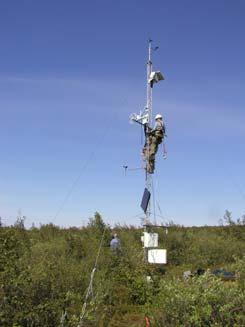
8 Tundra Main Met and MSC station Trail Valley Creek Shrub WSC TVC discharge Tundra station Shrub Forest Drift
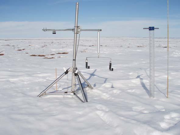
9 Field Observation of snow and soil temperature Four vegetation & terrain types Tundra; Tall Shrub; Large drift; and Forest Measurements 5 sites at each domain (except only 1 at forest) Continuous snow depth: Campbell SR50 sonic ranging sensor Ground temperate at 5, 10, 20, and 40 cm using hobo loggers Meteorological stations at Tundra, Tall Shrub and Forest sites Air temperature, wind speed and direction, precipitation snow surveys Digital snow pillow at Forest site developed by CRREL in Alaska


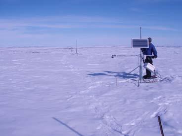
10 Tundra and drift sites Tundra Slope drift location South-east facing slope


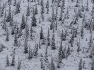
11 Tall Shrub and Forest Sites Shrub Forest No snow pillow data during winter 2009/10 due to a sensor failure early in the winter Digital snow pillow


12 Timing of field visits September 2009 October 2009 March 2010 April 2010
13 3. Hydrological modelling MAGS, IP3 and IPY studies have tested and improved a variety of models at Trail Valley Ck, including: CLASS Canadian Land Surface Scheme MESH CRHM Cold Regions Hydrological Model PBSM Prairie Blowing Snow Model GEOtop Liston wind model
 - subsurface flow (3D Richards equation) 3.")

14 In this study we will use GEOtop and PBSM 2. Water balance - effective rainfall - surface flow (runoff and channel routing) - subsurface flow (3D Richards equation) 3. Snow-glaciers - multilayer snow scheme - glacier mass balance - PBSM blowing snow 4. surface energy balance -radiation - boundary-layer interaction 1. Radiation - distributed model - sky view factor, self and cast shadowing, slope, aspect, drainage directions..: 6. vegetation interaction - multi-layer vegetation scheme - evapotranspiration 5. soil energy balance - soil temperature -freezing soil 1

.")
15 GEOtop The kernel of the model is a spatially distributed, coupled numerical solution of the subsurface flow (3D Richards equation) and energy budget (1D heat equation with phase change). This applies for soil and snow cover. 2
 PBSM (Pomeroy et al.")
16 Blowing snow GEOtop coupled with: 1) Micromet (Liston and Elder, 2006) to find a topographically consistent wind field, even if only based on curvature and slope. Tested at TVC by Pohl et al. for the simple terrain of TVC 2) PBSM (Pomeroy et al., 1993) to find snow wind transport rate and sublimation, assuming steady state conditions 10
17 Other aspects of GEOtop have been considered to date Sensible and latent heat flux Snowcovered and snowfree terrain Tundra and tall shrub tundra Various scales Point (from tower) 3km x 3 km (from aircraft) Snow Covered area (SCA) Compare modelled SCA to SPOT and air photos during melt Frost table development Spatial and temporal changes in frost table depth during the summer
 Shrub site 20 m grid sizes2 m contours - SR50")
18 Modelling domain (1.2 km x 1.2 km) Shrub site 20 m grid sizes2 m contours - SR50 sites - Model averaging area
 Tundra site 20 m grid sizes - SR50 sites -")
19 Modelling domain (1.2 km x 1.2 km) Tundra site 20 m grid sizes - SR50 sites - Model averaging area
 Drift site 20 m grid sizes - SR50 sites -")
20 Modelling domain (1.2 km x 1.2 km) Drift site 20 m grid sizes - SR50 sites - Model averaging area
 Forest site 20 m grid sizes - SR50 sites -")
21 Modelling domain (1.2 km x 1.2 km) Forest site 20 m grid sizes - SR50 sites - Model averaging area
22 4. Results to date Snowfall Adjusted for wind speed Raw data Unadjusted We had planned to compare measured snowfall to snow on the ground at the forest site from the snow pillow
23 Observed and Modelled Snow depth Shrub model Shrub model Snow Depth (mm) Tundra Drift? model SR50s offset reset by field staff model Modelled Compaction appears to large Forest? model - Observations = average 5 sites - model = avg of small domain

24 Snow accumulation tundra site

25 Snow accumulation drift site Note large drift on SE and small or no drift on NW slopes Lower depths below scale on right SE 1.2 km NW
26 Tundra soil temperature Air Temperature Temperature (C) Model is too warm at all depths. Possibly due to overestimating snow depth 5 cm 10 cm 20 cm 40 cm
27 Soil temp during key early winter period Tundra snow depth GEOtop SR50 error Soil temperature at 20 cm GEOtop -5C September 2009/10 December
28 5. Conclusions GEOtop + PBS do a reasonable job in modelling snow depth and soil temperature, but not sufficiently good at the moment for regulatory needs A number of issues are being investigated SR50 issues at some of the sites why did they not work during portions of the winter? GEOtop snow compaction and densification routines need improving Once these issues are improved Are the models able to estimate not only the avg depth of the snowcover, but also the spatial variability as shown by the coefficient of variation for example Look at the spatial variability in key soil temperatures needed to consider land access. Can we map key soil temperature across large areas so that INAC can use these in developing regulations Discussions with INAC re regulations for land access
APPLICATION OF AN ARCTIC BLOWING SNOW MODEL
 APPLICATION OF AN ARCTIC BLOWING SNOW MODEL J.W. Pomero l, P. ~arsh' and D.M. Gray2 -Hydrology Research Institute Saskatoon, Saskatchewan, Canada S7N 3H5 '~ivision of Hydrology, University of Saskatchewan
Winter Precipitation, Sublimation, and Snow-Depth in the Pan-Arctic: Critical Processes and a Half Century of Change
 Winter Precipitation, Sublimation, and Snow-Depth in the Pan-Arctic: Critical Processes and a Half Century of Change PI s: Glen E. Liston, Colorado State University Larry J. Mahrt, Oregon State University
P. Marsh and J. Pomeroy National Hydrology Research Institute 11 Innovation Blvd., Saskatoon, Sask. S7N 3H5
 WATER AND ENERGY FLUXES DURING THE SNOWMELT PERIOD AT AN ARCTIC TREELINE SITE P. Marsh and J. Pomeroy National Hydrology Research Institute 11 Innovation Blvd., Saskatoon, Sask. S7N 3H5 marshp@nhrisv.nhrc.skdoe.ca
Flood Forecasting Tools for Ungauged Streams in Alberta: Status and Lessons from the Flood of 2013
 Flood Forecasting Tools for Ungauged Streams in Alberta: Status and Lessons from the Flood of 2013 John Pomeroy, Xing Fang, Kevin Shook, Tom Brown Centre for Hydrology, University of Saskatchewan, Saskatoon
Land Surface: Snow Emanuel Dutra
 Land Surface: Snow Emanuel Dutra emanuel.dutra@ecmwf.int Slide 1 Parameterizations training course 2015, Land-surface: Snow ECMWF Outline Snow in the climate system, an overview: Observations; Modeling;
Land-Surface-Hydrological Models for Environmental Prediction
 Land-Surface-Hydrological Models for Environmental Prediction Dr. Alain Pietroniro P.Eng. Director Water Survey of Canada Environment Canada Dr. John Pomeroy Centre for Hydrology University of Saskatchewan
2017 Fall Conditions Report
 2017 Fall Conditions Report Prepared by: Hydrologic Forecast Centre Date: November 15, 2017 Table of Contents TABLE OF FIGURES... ii EXECUTIVE SUMMARY... 1 BACKGROUND... 4 SUMMER AND FALL PRECIPITATION...
Snowcover interaction with climate, topography & vegetation in mountain catchments
 Snowcover interaction with climate, topography & vegetation in mountain catchments DANNY MARKS Northwest Watershed Research Center USDA-Agricultural Agricultural Research Service Boise, Idaho USA RCEW
2015 Fall Conditions Report
 2015 Fall Conditions Report Prepared by: Hydrologic Forecast Centre Date: December 21 st, 2015 Table of Contents Table of Figures... ii EXECUTIVE SUMMARY... 1 BACKGROUND... 2 SUMMER AND FALL PRECIPITATION...
Impacts of snowpack accumulation and summer weather on alpine glacier hydrology
 Impacts of snowpack accumulation and summer weather on alpine glacier hydrology Caroline Aubry-Wake, Dhiraj Pradhananga, John W. Pomeroy GEWEX 8 th Open Science Meeting, Canmore AB, May 3-11 2018 Canadian
2016 Fall Conditions Report
 2016 Fall Conditions Report Prepared by: Hydrologic Forecast Centre Date: December 13, 2016 Table of Contents TABLE OF FIGURES... ii EXECUTIVE SUMMARY... 1 BACKGROUND... 5 SUMMER AND FALL PRECIPITATION...
Remote Sensing of SWE in Canada
 Remote Sensing of SWE in Canada Anne Walker Climate Research Division, Environment Canada Polar Snowfall Hydrology Mission Workshop, June 26-28, 2007 Satellite Remote Sensing Snow Cover Optical -- Snow
S. R. FASSNACHT. Watershed Science, Colorado State University, Fort Collins, Colorado Z.-L. YANG
 298 J O U R N A L O F H Y D R O M E T E O R O L O G Y VOLUME 7 Effects of Averaging and Separating Soil Moisture and Temperature in the Presence of Snow Cover in a SVAT and Hydrological Model for a Southern
Extreme Weather and Climate Change: the big picture Alan K. Betts Atmospheric Research Pittsford, VT NESC, Saratoga, NY
 Extreme Weather and Climate Change: the big picture Alan K. Betts Atmospheric Research Pittsford, VT http://alanbetts.com NESC, Saratoga, NY March 10, 2018 Increases in Extreme Weather Last decade: lack
Canadian Prairie Snow Cover Variability
 Canadian Prairie Snow Cover Variability Chris Derksen, Ross Brown, Murray MacKay, Anne Walker Climate Research Division Environment Canada Ongoing Activities: Snow Cover Variability and Links to Atmospheric
A SURVEY OF HYDROCLIMATE, FLOODING, AND RUNOFF IN THE RED RIVER BASIN PRIOR TO 1870
 A SURVEY OF HYDROCLIMATE, FLOODING, AND RUNOFF IN THE RED RIVER BASIN PRIOR TO 1870 W. F. RANNIE (UNIVERSITY OF WINNIPEG) Prepared for the Geological Survey of Canada September, 1998 TABLE OF CONTENTS
Lecture 8: Snow Hydrology
 GEOG415 Lecture 8: Snow Hydrology 8-1 Snow as water resource Snowfall on the mountain ranges is an important source of water in rivers. monthly pcp (mm) 100 50 0 Calgary L. Louise 1 2 3 4 5 6 7 8 9 10
The elevations on the interior plateau generally vary between 300 and 650 meters with
 11 2. HYDROLOGICAL SETTING 2.1 Physical Features and Relief Labrador is bounded in the east by the Labrador Sea (Atlantic Ocean), in the west by the watershed divide, and in the south, for the most part,
Bugs in JRA-55 snow depth analysis
 14 December 2015 Climate Prediction Division, Japan Meteorological Agency Bugs in JRA-55 snow depth analysis Bugs were recently found in the snow depth analysis (i.e., the snow depth data generation process)
Terrestrial Snow Cover: Properties, Trends, and Feedbacks. Chris Derksen Climate Research Division, ECCC
 Terrestrial Snow Cover: Properties, Trends, and Feedbacks Chris Derksen Climate Research Division, ECCC Outline Three Snow Lectures: 1. Why you should care about snow: Snow and the cryosphere Classes of
A distributed model of blowing snow over complex terrain
 HYDROLOGICAL PROCESSES Hydrol. Process. 13, 2423±2438 (1999) A distributed model of blowing snow over complex terrain Richard Essery, 1 Long Li 1 and John Pomeroy 2 * 1 Division of Hydrology, University
The Use of Inductive and Deductive Reasoning to Model Snowmelt Runoff from Northern Mountain Catchments
 International Congress on Environmental Modelling and Software Brigham Young University BYU ScholarsArchive 3rd International Congress on Environmental Modelling and Software - Burlington, Vermont, USA
Snowmelt energetics at a shrub tundra site in the western Canadian Arctic
 HYDROLOGICAL PROCESSES Hydrol. Process. 24, 3603 3620 (2010) Published online 20 July 2010 in Wiley Online Library (wileyonlinelibrary.com) DOI: 10.1002/hyp.7786 Snowmelt energetics at a shrub tundra site
Regional offline land surface simulations over eastern Canada using CLASS. Diana Verseghy Climate Research Division Environment Canada
 Regional offline land surface simulations over eastern Canada using CLASS Diana Verseghy Climate Research Division Environment Canada The Canadian Land Surface Scheme (CLASS) Originally developed for the
Which map shows the stream drainage pattern that most likely formed on the surface of this volcano? A) B)
 B)") 1. When snow cover on the land melts, the water will most likely become surface runoff if the land surface is A) frozen B) porous C) grass covered D) unconsolidated gravel Base your answers to questions
1. When snow cover on the land melts, the water will most likely become surface runoff if the land surface is A) frozen B) porous C) grass covered D) unconsolidated gravel Base your answers to questions
North Slope Tundra Travel and Ice Road Construction By Alaska Department of Natural Resources. Wyn Menefee & Gary Schultz
 North Slope Tundra Travel and Ice Road Construction By Alaska Department of Natural Resources Wyn Menefee & Gary Schultz Exploratory and Production Wells on the North Slope Ice Road Construction Cross
International Snow Science Workshop
 Wind Effect on Snow Over Arctic Sea-ice: Evaluation of a Sea-ice / Snow / Blowing Snow Model Yi-Ching Chung *, Stéphane Bélair, and Jocelyn Mailhot Numerical Prediction Research Section, Meteorological
Surface & subsurface processes in mountain environments
 Surface & subsurface processes in mountain environments evapotranspiration snowmelt precipitation infiltration Roger Bales Martha Conklin Robert Rice Fengjing Liu Peter Kirchner runoff sublimation ground
1 What Is Climate? TAKE A LOOK 2. Explain Why do areas near the equator tend to have high temperatures?
 CHAPTER 17 1 What Is Climate? SECTION Climate BEFORE YOU READ After you read this section, you should be able to answer these questions: What is climate? What factors affect climate? How do climates differ
Regional Climate Change: Current Impacts and Perspectives Greater Lake Nipissing Stewardship Council Annual Meeting Wednesday April 16, 2014
 Regional Climate Change: Current Impacts and Perspectives Greater Lake Nipissing Stewardship Council Annual Meeting Wednesday April 16, 2014 Speaker: Peter Bullock, Stantec Consulting Information Source:
Climate change projections for Ontario: an updated synthesis for policymakers and planners
 Ministry of Natural Resources and Forestry Climate change projections for Ontario: an updated synthesis for policymakers and planners Shannon Fera and Adam Hogg Ontario Ministry of Natural Resources and
MELTWATER FLUXES AT AN ARCTIC FOREST-TUNDRA SITE
 HYDROLOGICAL PROCESSES, VOL. 1, 1383-14 (1996) MELTWATER FLUXES AT AN ARCTIC FOREST-TUNDRA SITE P. MARSH AND J. W. POMEROY National Hydrology Research Institute, I I Innovation Blvd., Saskatoon, Saskatc~ew~n,
Hydrologic Forecast Centre Manitoba Infrastructure, Winnipeg, Manitoba. FEBRUARY OUTLOOK REPORT FOR MANITOBA February 23, 2018
 Page 1 of 17 Hydrologic Forecast Centre Manitoba Infrastructure, Winnipeg, Manitoba FEBRUARY OUTLOOK REPORT FOR MANITOBA February 23, 2018 Overview The February Outlook Report prepared by the Hydrologic
1 What Is Climate? TAKE A LOOK 2. Explain Why do areas near the equator tend to have high temperatures?
 CHAPTER 17 1 What Is Climate? SECTION Climate BEFORE YOU READ After you read this section, you should be able to answer these questions: What is climate? What factors affect climate? How do climates differ
Fate of permafrost in Denali National Park and Preserve - A modeling investigation
 Photo credit: Jacob W Frank Fate of permafrost in Denali National Park and Preserve - A modeling investigation Santosh K Panda, Sergey S Marchenko, Vladimir E Romanovsky Permafrost Laboratory, Geophysical
World Geography Chapter 3
 World Geography Chapter 3 Section 1 A. Introduction a. Weather b. Climate c. Both weather and climate are influenced by i. direct sunlight. ii. iii. iv. the features of the earth s surface. B. The Greenhouse
Souris River Basin Spring Runoff Outlook As of March 15, 2018
 Souris River Basin Spring Runoff Outlook As of March 15, 2018 Prepared by: Flow Forecasting & Operations Planning Water Security Agency Basin Conditions Summer rainfall in 2017 in the Saskatchewan portion
Seasonal and Spatial Patterns of Rainfall Trends on the Canadian Prairie
 Seasonal and Spatial Patterns of Rainfall Trends on the Canadian Prairie H.W. Cutforth 1, O.O. Akinremi 2 and S.M. McGinn 3 1 SPARC, Box 1030, Swift Current, SK S9H 3X2 2 Department of Soil Science, University
1. GLACIER METEOROLOGY - ENERGY BALANCE
 Summer School in Glaciology McCarthy, Alaska, 5-15 June 2018 Regine Hock Geophysical Institute, University of Alaska, Fairbanks 1. GLACIER METEOROLOGY - ENERGY BALANCE Ice and snow melt at 0 C, but this
Thomas P. Phillips CIRES Prof K. Steffen, L. Colgan PhD ABD, D. McGrath MA
 Thomas P. Phillips CIRES Prof K. Steffen, L. Colgan PhD ABD, D. McGrath MA Problem: we know very little about the processes happening within the Greenland Ice Sheet. What is the velocity at the base? What
J8.4 TRENDS OF U.S. SNOWFALL AND SNOW COVER IN A WARMING WORLD,
 J8.4 TRENDS OF U.S. SNOWFALL AND SNOW COVER IN A WARMING WORLD, 1948-2008 Richard R. Heim Jr. * NOAA National Climatic Data Center, Asheville, North Carolina 1. Introduction The Intergovernmental Panel
Using MODIS imagery to validate the spatial representation of snow cover extent obtained from SWAT in a data-scarce Chilean Andean watershed
 Using MODIS imagery to validate the spatial representation of snow cover extent obtained from SWAT in a data-scarce Chilean Andean watershed Alejandra Stehr 1, Oscar Link 2, Mauricio Aguayo 1 1 Centro
CLIMATE. UNIT TWO March 2019
 CLIMATE UNIT TWO March 2019 OUTCOME 9.2.1Demonstrate an understanding of the basic features of Canada s landscape and climate. identify and locate major climatic regions of Canada explain the characteristics
Boundary-layer integration approach to advection of sensible heat to a patchy snow cover
 HYDROLOGICAL PROCESSES Hydrol. Process. 16, 3559 3569 (2002) Published online in Wiley InterScience (www.interscience.wiley.com). DOI: 10.1002/hyp.1227 Boundary-layer integration approach to advection
The importance of long-term Arctic weather station data for setting the research stage for climate change studies
 The importance of long-term Arctic weather station data for setting the research stage for climate change studies Taneil Uttal NOAA/Earth Systems Research Laboratory Boulder, Colorado Things to get out
Souris River Basin Spring Runoff Outlook As of March 1, 2019
 Souris River Basin Spring Runoff Outlook As of March 1, 2019 Prepared by: Flow Forecasting & Operations Planning Water Security Agency Basin Conditions Summer rainfall in 2018 over the Saskatchewan portion
Analysis of real-time prairie drought monitoring and forecasting system. Lei Wen and Charles A. Lin
 Analysis of real-time prairie drought monitoring and forecasting system Lei Wen and Charles A. Lin Back ground information A real-time drought monitoring and seasonal prediction system has been developed
Radiative Climatology of the North Slope of Alaska and the Adjacent Arctic Ocean
 Radiative Climatology of the North Slope of Alaska and the Adjacent Arctic Ocean C. Marty, R. Storvold, and X. Xiong Geophysical Institute University of Alaska Fairbanks, Alaska K. H. Stamnes Stevens Institute
Storm and Runoff Calculation Standard Review Snowmelt and Climate Change
 Storm and Runoff Calculation Standard Review Snowmelt and Climate Change Presented by Don Moss, M.Eng., P.Eng. and Jim Hartman, P.Eng. Greenland International Consulting Ltd. Map from Google Maps TOBM
1 What Is Climate? TAKE A LOOK 2. Explain Why do areas near the equator tend to have high temperatures?
 CHAPTER 3 1 What Is Climate? SECTION Climate BEFORE YOU READ After you read this section, you should be able to answer these questions: What is climate? What factors affect climate? How do climates differ
SNOW AND GLACIER HYDROLOGY
 SNOW AND GLACIER HYDROLOGY by PRATAP SINGH National Institute of Hydrology, Roorkee, India and VIJAY P. SINGH Department of Civil and Environmental Engineering, Louisiana State University, Baton Rouge,
Nonuniform Distribution of Tundra Snow Cover in Eastern Siberia
 VOLUME 5 JOURNAL OF HYDROMETEOROLOGY JUNE 2004 Nonuniform Distribution of Tundra Snow Cover in Eastern Siberia HIROYUKI HIRASHIMA,* TETSUO OHATA,* YUJI KODAMA,* HIRONORI YABUKI, NORIFUMI SATO,* AND ALEXANDER
Recent studies and plans on subjects related to NEESPI at JAMSTEC and other Japanese plans
 Recent studies and plans on subjects related to NEESPI at JAMSTEC and other Japanese plans Tetsuo Ohata Program Director IORGC/JAMSTEC, Yokosuka, Japan REGIONAL WATER CYCLE C SNOW COVER P E R C http://www.jamstec.go.jp
Climate Change and Arctic Ecosystems
 itletitle Climate Change and Arctic Ecosystems Climate Change and Arctic Ecosystems Key Concepts: Greenhouse Gas Albedo Ecosystem Sea ice Vegetative zone WHAT YOU WILL LEARN 1. You will analyze Arctic
Climatic Change Implications for Hydrologic Systems in the Sierra Nevada
 Climatic Change Implications for Hydrologic Systems in the Sierra Nevada Part Two: The HSPF Model: Basis For Watershed Yield Calculator Part two presents an an overview of why the hydrologic yield calculator
Preliminary Runoff Outlook February 2018
 Preliminary Runoff Outlook February 2018 Prepared by: Flow Forecasting & Operations Planning Water Security Agency General Overview The Water Security Agency (WSA) is preparing for 2018 spring runoff including
Supplement of Carbon stocks and fluxes in the high latitudes: using site-level data to evaluate Earth system models
 Supplement of Biogeosciences, 14, 5143 5169, 2017 https://doi.org/10.5194/bg-14-5143-2017-supplement Author(s) 2017. This work is distributed under the Creative Commons Attribution 3.0 License. Supplement
Coupling Climate to Clouds, Precipitation and Snow
 Coupling Climate to Clouds, Precipitation and Snow Alan K. Betts akbetts@aol.com http://alanbetts.com Co-authors: Ray Desjardins, Devon Worth Agriculture and Agri-Food Canada Shusen Wang and Junhua Li
Effects of forest cover and environmental variables on snow accumulation and melt
 Effects of forest cover and environmental variables on snow accumulation and melt Mariana Dobre, William J. Elliot, Joan Q. Wu, Timothy E. Link, Ina S. Miller Abstract The goal of this study was to assess
Snowmelt runoff sensitivity analysis to drought on the Canadian prairies
 HYDROLOGICAL PROCESSES Hydrol. Process. 21, 2594 2609 (2007) Published online in Wiley InterScience (www.interscience.wiley.com).6796 Snowmelt runoff sensitivity analysis to drought on the Canadian prairies
Evaluation of a Low cost Drifting Buoy equipped with a Sonic Anemometer
 Evaluation of a Low cost Drifting Buoy equipped with a Sonic Anemometer Chris Marshall Environment Canada National Manager of Marine Monitoring Findings first presented at CMOS Conference, Montreal by
1.5 Biome-scale Representation of Snow Cover Development and Ablation in Boreal and Tundra Ecosystems
 1.5 Biome-scale Representation of Snow Cover Development and Ablation in Boreal and Tundra Ecosystems John Pomeroy 1 (presenter), Don Gray 2, Raoul Granger 3, Phil Marsh 3, Newell Hedstrom 3, Richard Janowicz
Climates of NYS. Definitions. Climate Regions of NYS. Storm Tracks. Climate Controls 10/13/2011. Characteristics of NYS s Climates
 Definitions Climates of NYS Prof. Anthony Grande 2011 Weather and Climate Weather the state of the atmosphere at one point in time. The elements of weather are temperature, air pressure, wind and moisture.
Prediction of Snow Water Equivalent in the Snake River Basin
 Hobbs et al. Seasonal Forecasting 1 Jon Hobbs Steve Guimond Nate Snook Meteorology 455 Seasonal Forecasting Prediction of Snow Water Equivalent in the Snake River Basin Abstract Mountainous regions of
Parameterizing redistribution and sublimation of blowing snow for hydrological models: tests in a mountainous subarctic catchment
 HYDROLOGICAL PROCESSES Hydrol. Process. 23, 2570 2583 (2009) Published online 6 July 2009 in Wiley InterScience (www.interscience.wiley.com).7356 Parameterizing redistribution and sublimation of blowing
Definitions Weather and Climate Climates of NYS Weather Climate 2012 Characteristics of Climate Regions of NYS NYS s Climates 1.
 Definitions Climates of NYS Prof. Anthony Grande 2012 Weather and Climate Weather the state of the atmosphere at one point in time. The elements of weather are temperature, t air pressure, wind and moisture.
Trends in Frost Dates, Frost Free Duration and Seasonal Temperature on the Canadian Prairie
 1 Trends in Frost Dates, Frost Free Duration and Seasonal Temperature on the Canadian Prairie Herb Cutforth 1, Ted O Brien 2, Jason Tuchelt 2 and Rick Rickwood 2 1 SPARC, Agriculture and Agri-Food Canada,
The hydrologic service area (HSA) for this office covers Central Kentucky and South Central Indiana.
 for this office covers Central Kentucky and South Central Indiana.") January 2012 February 13, 2012 An X inside this box indicates that no flooding occurred within this hydrologic service area. January 2012 continued the string of wet months this winter. Rainfall was generally
January 2012 February 13, 2012 An X inside this box indicates that no flooding occurred within this hydrologic service area. January 2012 continued the string of wet months this winter. Rainfall was generally
REGIONAL ACTIVE LAYER MONITORING ACROSS THE SPORADIC, DISCONTINUOUS AND CONTINUOUS PERMAFROST ZONES, MACKENZIE VALLEY, NORTHWESTERN CANADA
 REGIONAL ACTIVE LAYER MONITORING ACROSS THE SPORADIC, DISCONTINUOUS AND CONTINUOUS PERMAFROST ZONES, MACKENZIE VALLEY, NORTHWESTERN CANADA F. Mark Nixon 1, Alan E. Taylor 2 1. Geological Survey of Canada,
Annex I to Target Area Assessments
 Baltic Challenges and Chances for local and regional development generated by Climate Change Annex I to Target Area Assessments Climate Change Support Material (Climate Change Scenarios) SWEDEN September
THE CANADIAN CENTRE FOR CLIMATE MODELLING AND ANALYSIS
 THE CANADIAN CENTRE FOR CLIMATE MODELLING AND ANALYSIS As Canada s climate changes, and weather patterns shift, Canadian climate models provide guidance in an uncertain future. CANADA S CLIMATE IS CHANGING
The Northern Hemisphere Sea ice Trends: Regional Features and the Late 1990s Change. Renguang Wu
 The Northern Hemisphere Sea ice Trends: Regional Features and the Late 1990s Change Renguang Wu Institute of Atmospheric Physics, Chinese Academy of Sciences, Beijing World Conference on Climate Change
Chapter 6, Part Colonizers arriving in North America found extremely landscapes. It looked different to region showing great.
 Social Studies 9 Unit 1 Worksheet Chapter 6, Part 1. 1. Colonizers arriving in North America found extremely landscapes. It looked different to region showing great. 2. The Earth is years old and is composed
Biomes There are 2 types: Terrestrial Biomes (on land) Aquatic Biomes (in the water)
 Aquatic Biomes (in the water)") Biomes There are 2 types: Terrestrial Biomes (on land) Aquatic Biomes (in the water) Terrestrial Biomes Grassland, Desert, and Tundra Biomes: Savanna Temperate grassland Chaparral Desert Tundra Chapter
Biomes There are 2 types: Terrestrial Biomes (on land) Aquatic Biomes (in the water) Terrestrial Biomes Grassland, Desert, and Tundra Biomes: Savanna Temperate grassland Chaparral Desert Tundra Chapter
Coupling of Diurnal Climate to Clouds, Land-use and Snow
 Coupling of Diurnal Climate to Clouds, Land-use and Snow Alan K. Betts akbetts@aol.com http://alanbetts.com Co-authors: Ray Desjardins, Devon Worth, Darrel Cerkowniak Agriculture and Agri-Food Canada Shusen
forest tropical jungle swamp marsh prairie savanna pampas Different Ecosystems (rainforest)
") Different Ecosystems forest A region of land that is covered with many trees and shrubs. tropical jungle (rainforest) swamp A region with dense trees and a variety of plant life. It has a tropical climate.
Different Ecosystems forest A region of land that is covered with many trees and shrubs. tropical jungle (rainforest) swamp A region with dense trees and a variety of plant life. It has a tropical climate.
Hydrologic Forecast Centre Manitoba Infrastructure, Winnipeg, Manitoba. MARCH OUTLOOK REPORT FOR MANITOBA March 23, 2018
 Page 1 of 21 Hydrologic Forecast Centre Manitoba Infrastructure, Winnipeg, Manitoba MARCH OUTLOOK REPORT FOR MANITOBA March 23, 2018 Overview The March Outlook Report prepared by the Hydrologic Forecast
Climate Change Adaptation
 Climate Change Adaptation Adriána Hudecz, Technical University of Denmark ROADEX Final Seminar Rovaniemi, 25 April 2012 Climate Change Adaptation Outline: 1. Background/global climate change 2. Climate
ESTIMATING SNOWMELT CONTRIBUTION FROM THE GANGOTRI GLACIER CATCHMENT INTO THE BHAGIRATHI RIVER, INDIA ABSTRACT INTRODUCTION
 ESTIMATING SNOWMELT CONTRIBUTION FROM THE GANGOTRI GLACIER CATCHMENT INTO THE BHAGIRATHI RIVER, INDIA Rodney M. Chai 1, Leigh A. Stearns 2, C. J. van der Veen 1 ABSTRACT The Bhagirathi River emerges from
The weather in Iceland 2012
 The Icelandic Meteorological Office Climate summary 2012 published 9.1.2013 The weather in Iceland 2012 Climate summary Sunset in Reykjavík 24th April 2012 at 21:42. View towards west from the balcony
Geography Class XI Fundamentals of Physical Geography Section A Total Periods : 140 Total Marks : 70. Periods Topic Subject Matter Geographical Skills
 Geography Class XI Fundamentals of Physical Geography Section A Total Periods : 140 Total Marks : 70 Sr. No. 01 Periods Topic Subject Matter Geographical Skills Nature and Scope Definition, nature, i)
NOTES AND CORRESPONDENCE. Mapping At Risk Snow in the Pacific Northwest
 1164 J O U R N A L O F H Y D R O M E T E O R O L O G Y VOLUME 7 NOTES AND CORRESPONDENCE Mapping At Risk Snow in the Pacific Northwest ANNE W. NOLIN AND CHRISTOPHER DALY Oregon State University, Corvallis,
Seasons, Global Wind and Climate Study Guide
 Seasons, Global Wind and Climate Study Guide Seasons 1. Know what is responsible for the change in seasons on Earth. 2. Be able to determine seasons in the northern and southern hemispheres given the position
Persistence of Soil Moisture in the Cariboo Mountains, BC
 Persistence of Soil Moisture in the Cariboo Mountains, BC Tullia Leona Upton University of Northern Brithish Columbia M.Sc. Candidate Natural Resources and Environmental Studies upton@unbc.ca Overview
Weather Atmospheric condition in one place during a limited period of time Climate Weather patterns that an area typically experiences over a long
 Weather Atmospheric condition in one place during a limited period of time Climate Weather patterns that an area typically experiences over a long period of time Many factors influence weather & climate
Champaign-Urbana 2000 Annual Weather Summary
 Champaign-Urbana 2000 Annual Weather Summary ILLINOIS STATE WATER SURVEY 2204 Griffith Dr. Champaign, IL 61820 wxobsrvr@sws.uiuc.edu Maria Peters, Weather Observer January: January started on a mild note,
Climate of Alaska: Past, Present and Future
 Climate of Alaska: Past, Present and Future Pond shrinkage in Alaska's Yukon Flats National Wildlife Refuge, 1951-2000. Source: USGCRP (2009) Uma S. Bhatt, usbhatt@alaska.edu John Walsh for many of today
but 2012 was dry Most farmers pulled in a crop
 After a winter that wasn t, conditions late in the year pointed to a return to normal snow and cold conditions Most farmers pulled in a crop but 2012 was dry b y M i k e Wr o b l e w s k i, w e a t h e
Quenching the Valley s thirst: The connection between Sierra Nevada snowpack & regional water supply
 Quenching the Valley s thirst: The connection between Sierra Nevada snowpack & regional water supply Roger Bales, UC Merced Snow conditions Snow & climate change Research directions Sierra Nevada snow
EC-PORS III Research. Sodankylä, February Developing a Polar Prediction System
 EC-PORS III Research Sodankylä, February 2012 Developing a Polar Prediction System Polar Prediction System - Status 1. EC-PORS I (Oct. 2009) -> initial discussions 2. WWRP/THORPEX Polar Prediction Workshop,
Lake Tahoe Watershed Model. Lessons Learned through the Model Development Process
 Lake Tahoe Watershed Model Lessons Learned through the Model Development Process Presentation Outline Discussion of Project Objectives Model Configuration/Special Considerations Data and Research Integration
GLOBAL WARMING: GLOBAL WARMING. landscape implications. Andrew Goudie St Cross College Oxford
 GLOBAL WARMING: GLOBAL WARMING landscape implications Andrew Goudie St Cross College Oxford THE PROCESS OF CHANGE HAS STARTED IPCC 2007 Increased Glacier retreat since the early 1990s Area of seasonally
NIDIS Intermountain West Drought Early Warning System February 12, 2019
 NIDIS Intermountain West Drought Early Warning System February 12, 2019 Precipitation The images above use daily precipitation statistics from NWS COOP, CoCoRaHS, and CoAgMet stations. From top to bottom,
National Framework for Glacier Monitoring & Assessment National-scale Reference :
 National Framework for Glacier Monitoring & Assessment National-scale Reference : Western & Northern Cordillera High Arctic (Queen Elizabeth Islands) Low Arctic (Baffin Island) emphasis on long time series
Climate Change Adaptation
 Climate Change Adaptation Adriána Hudecz, Technical University of Denmark ROADEX Final Seminar Inverness, 22 May 2012 Climate Change Adaptation Outline: 1. Background/global climate change 2. Climate change
Water Cycle Prediction on the Prairies
 Water Cycle Prediction on the Prairies A. Pietroniro, S. Marin, A. Liu, B. Davison, B. Toth, D. Shaw(AAFC), L. Martz Hydrometerology and Arctic Lab, Environment Canada, NHRC and Centre for Hydrology, University
Energy and Mass Balance Snow Model. Department of Civil and Environmental Engineering University of Washington
 SnowSTAR2002 STAR2002 TransectReconstruction ti Ui Using a Multilayered Energy and Mass Balance Snow Model Xiaogang Shi and Dennis P. Lettenmaier Department of Civil and Environmental Engineering University
Minnesota s Changing Climate: Winter Impacts
 Minnesota s Changing Climate: Winter Impacts Dr. Mark Seeley Climatologist/Meteorologist Dept of Soil, Water, and Climate University of Minnesota 15 th Annual Road Salt Symposium Minnesota Landscape Arboretum
Modeling the Arctic Climate System
 Modeling the Arctic Climate System General model types Single-column models: Processes in a single column Land Surface Models (LSMs): Interactions between the land surface, atmosphere and underlying surface
Weather Atmospheric condition in one place during a limited period of time Climate Weather patterns that an area typically experiences over a long
 Weather Atmospheric condition in one place during a limited period of time Climate Weather patterns that an area typically experiences over a long period of time Many factors influence weather & climate