Modification of global precipitation data for enhanced hydrologic modeling of tropical montane watersheds
|
|
|
- Lynne Coleen French
- 5 years ago
- Views:
Transcription


1 Modification of global precipitation data for enhanced hydrologic modeling of tropical montane watersheds Michael Strauch, Rohini Kumar, Stephanie Eisner, Mark Mulligan, Julia Reinhardt, William Santini, Tobias Vetter, Jan Friesen SESSION B4: SWAT REVIEW PAPERS AND LARGE SCALE APPLICATIONS
")


2 MOTIVATION coordinated by ISI-MIP Inter-Sectoral Impact Model Integration and Intercomparison Project (Phase 2a) community-driven modelling effort Focus regions for catchment-scale hydrological modelling bringing together impact models across sectors and scales to create consistent and comprehensive projections of the impacts of different levels of global warming SEITE 2
 for montane subbasins")
3 MOTIVATION Upper Amazon Basin km² large elevation range Amazonian lowlands: tropical rain forest Andean region: montane forests, shrubland, grassland unreasonably high runoff coefficients (R / P) for montane subbasins errors in the data? R: 5-10% (Filizola et al., 2009) P: (WFDEI*) huge uncertainty! (1) complex terrain (2) cloudwater interception SEITE 3 * WFDEI: WATCH Forcing Data methodology applied to ERA-Interim data (Weedon et al., 2014)

 daily resolution basin-wide annual mean (2132 mm) is")

4 Problem 1: Complex terrain Average daily precipitation (mm) ( ) calculated from TRMM PR 2A25 including error model from subsampling the TMPA Weedon et al. (2014) global 0.5 grid (used in ISIMIP2) daily resolution basin-wide annual mean (2132 mm) is close to ground-based HYBAM product (2143 mm) Nesbitt and Anders (2009) 0.05 grid between 36 N/S climatology (only average rates!) annual mean too low (1707 mm), but gradients are resolved more reasonably SEITE 4
 Clark et al.")
5 Problem 2: Cloud water interception in tropical montane cloud forests Cloud water interception (CWI) is an unaccounted source of water CWI varies strongly and can reach values of more than 1000 mm yr -1 (e.g. Bruijnzeel et al., 2011) Clark et al. (2014) calculated a cloud water contribution of 316 ± 116 mm (or 11 ± 4%) to annual streamflow for the Kosñipata catchment in the eastern Peruvian Andes using an isotopic mixing model Source: Mulligan (2010) SEITE 5
, 0.05 grid WFDEI average precipitation rate (mm/day in 1998-2008), 0.")
6 METHODS (1) TRMM correction Adjustment of WFDEI data TRMM average precipitation rate (mm/day in ), 0.05 grid WFDEI average precipitation rate (mm/day in ), 0.5 grid SEITE 6
, 0.5 grid SEITE 7")
7 METHODS (1) TRMM correction Adjustment of WFDEI data TRMM average precipitation rate (mm/day in ), 0.5 grid Step 1: Aggregate TRMM to 0.5 WFDEI average precipitation rate (mm/day in ), 0.5 grid SEITE 7
 Step")
 0.")
8 METHODS (1) TRMM correction Adjustment of WFDEI data TRMM normalized (TRMM_norm) Step 2: Divide grid cell values by basin average WFDEI normalized (WFDEI_norm) SEITE 8

9 METHODS (1) TRMM correction Adjustment of WFDEI data TRMM correction factors (α) Step 3: αα ii,ss = TRMM_norm ii,ss WFDEI_norm ii,ss ii: individual 0.5 grid cell ss: season tt: day Step 4: WFDEI_TRMM ii,ss,tt = αα ii,ss WFDEI ii,ss,tt SEITE 9

 Two scenarios: γ = 0.15, γ = 0.")
10 METHODS Adjustment of WFDEI data (2) CWI correction Cloud forest coverage CWI correction factor 1: β β = aggregated (0.5 ) coverage as fraction between 0 and 1 CWI correction factor 2: γ = fraction of CWI on precipitation (constant) Two scenarios: γ = 0.15, γ = 0.5 WFDEI_CWI ii,tt = (1 + γγ ββ ii )WFDEI ii,tt Source: Mulligan (2010) WFDEI_TRMM_CWI ii,tt = (1 + γγ ββ ii )WFDEI_TRMM ii,tt SEITE 10
 mhm (Kumar et al., 2013; Samaniego et al., 2010) SWAT (Arnold et al., 1998; modified for tropical plant growth: Strauch and Volk, 2013) SWIM (Krysanova et al.")
11 METHODS Test with hydrologic model ensemble Input precipitation datasets: WFDEI WFDEI_CWI15 WFDEI_CWI50 WFDEI_TRMM WFDEI_TRMM_CWI15 WFDEI_TRMM_CWI50 Hydrologic models (uncalibrated): HBV model (Bergström, 1995) mhm (Kumar et al., 2013; Samaniego et al., 2010) SWAT (Arnold et al., 1998; modified for tropical plant growth: Strauch and Volk, 2013) SWIM (Krysanova et al., 1998) WaterGAP3 (Verzano, 2009) Simulation period: datasets x 5 models x 9 gauges = 270 simulation results Can we achieve better model performance with adjusted precipitation? SEITE 11
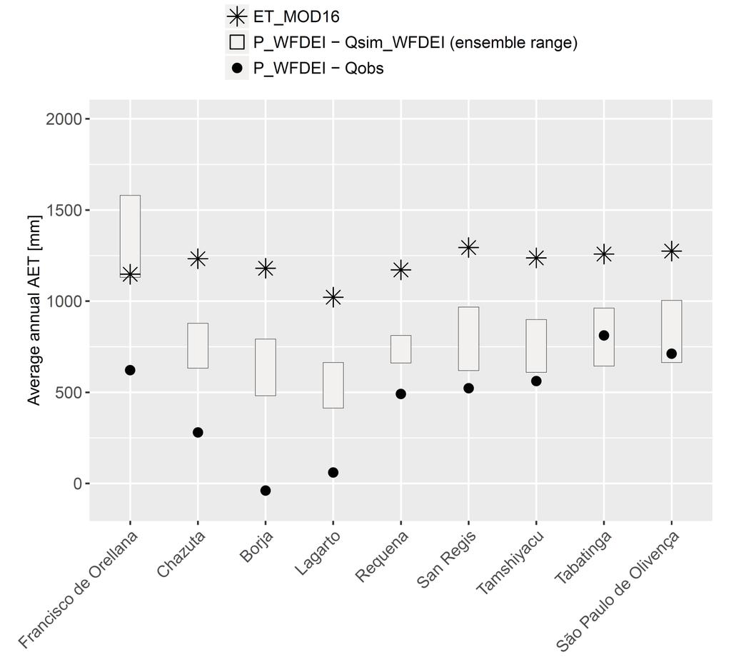
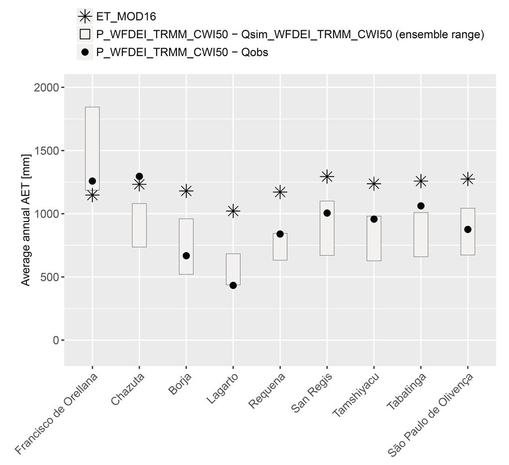
12 RESULTS Simulations using adjusted precipitation Simulations using WFDEI precipitation SEITE 12

13 RESULTS Nash-Sutcliffe efficiency (NSE) for the ensemble mean Amazonian lowland Andean region SEITE 13
14 CONCLUSIONS Unrealistically high R/P coefficients point to errors in the data assuming stationarity of long-term water storages, e.g. glaciers! Our approach to adjust daily precipitation data is simple but plausible, accounting for complex terrain gradients and/or cloud water interception (but not for temporal dynamics!) is based on freely available tropics-wide data generally increased model performance in the UAB (but differently across gauges) should be transferable to other tropical montane regions SEITE 14

15 THANK YOU
16 REFERENCES Arnold, J.G., Srinivasan, R., Muttiah, R., Williams, J., Large area hydrologic modeling and assessment part I: Model development. Journal of the American Water Resources Association, 34: Bergström, S., The HBV model. In: Singh, V.P. (Ed.), Computer Models of Watershed Hydrology. Water Resources Publications, Highlands Ranch, CO., pp Bruijnzeel, L.A., Mulligan, M., Scatena, F.N., Hydrometeorology of tropical montane cloud forests: emerging patterns. Hydrological Processes, 25(3): Clark, K.E. et al., The hydrological regime of a forested tropical Andean catchment. Hydrol. Earth Syst. Sci., 18(12): Kumar, R., Samaniego, L., Attinger, S., Implications of distributed hydrologic model parameterization on water fluxes at multiple scales and locations. Water Resources Research, 49(1): Krysanova, V., Müller-Wohlfeil, D.-I., Becker, A., Development and test of a spatially distributed hydrological/water quality model for mesoscale watersheds. Ecological Modelling, 106(2 3): Mulligan, M., Modelling the tropics-wide extent and distribution of cloud forests and cloud forest loss with implications for their conservation priority. In: Hamilton, L.S. (Ed.), Tropical Montane Cloud Forests. International hydrology series. Cambridge University Press, Cambridge and New York, pp Nesbitt, S.W., Anders, A.M., Very high resolution precipitation climatologies from the Tropical Rainfall Measuring Mission precipitation radar. Geophysical Research Letters, 36(15): L Samaniego, L., Kumar, R., Attinger, S., Multiscale parameter regionalization of a grid-based hydrologic model at the mesoscale. Water Resources Research, 46(5): W Strauch, M., Volk, M., SWAT plant growth modification for improved modeling of perennial vegetation in the tropics. Ecological Modelling, 269: Verzano, K., Climate change impacts on flood related hydrological processes: Further development and application of a global scale hydrological model. PhD Thesis, University of Kassel, Kassel. Weedon, G.P. et al., The WFDEI meteorological forcing data set: WATCH Forcing Data methodology applied to ERA-Interim reanalysis data. Water Resources Research, 50(9): SEITE 16
17 APPENDIX EQUATIONS TRMM corrected precipitation WW TTii,ss,tt = αα ii,ss WW ii,ss,tt TT ii,ss 1 NN ii=1 WW = αα ii,ss NN ii,ss 1 TT NN ii,ss NN ii=1 WW ii,ss CWI corrected precipitation WW ii,tt = (1 + γγ ββ ii )WW ii,tt ii: individual 0.5 grid cell ss: season (DJF, MAM, JJA, or SON) tt: day TRMM and CWI corrected precipitation WW TT ii,tt = (1 + γγ ββ ii ) WW TT ii,tt αα: TRMM correction factor WW: WFDEI precipitation TT: average daily precipitation rate (mm) of TRMM WW: average daily precipitation rate (mm) of WFDEI NN: total number of all grid cells in the UAB (405) γγ: CWI correction factor 2 (CWI fraction on P, 0.15 or 0.5) ββ: CWI correction factor 1 (cloud forest coverage) SEITE 17
 SEITE")
18 APPENDIX Spatial distribution of adjusted precipitation (mean) SEITE 18
19 APPENDIX Evapotranspiration SEITE 19
20 APPENDIX Evapotranspiration SEITE 20
Setting up SWAT for the Upper Amazon
 2014 International SWAT Conference Setting up SWAT for the Upper Amazon Michael Strauch, Martin Volk 2014 International SWAT Conference Porto de Galinhas, July 30 August 1, 2014 ISI-MIP2 Inter-Sectoral
A downscaling and adjustment method for climate projections in mountainous regions
 A downscaling and adjustment method for climate projections in mountainous regions applicable to energy balance land surface models D. Verfaillie, M. Déqué, S. Morin, M. Lafaysse Météo-France CNRS, CNRM
High resolution spatiotemporal distribution of rainfall seasonality and extreme events based on a 12-year TRMM time series
 High resolution spatiotemporal distribution of rainfall seasonality and extreme events based on a 12-year TRMM time series Bodo Bookhagen, Geography Department, UC Santa Barbara, Santa Barbara, CA 93106-4060
Runoff-rainfall modelling: Predicting areal precipitation from runoff observations
 HydroPredict 212 Session M: Methodology, modelling, prediction and uncertainty 24. 27. September 212, Runoff-rainfall modelling: Predicting areal precipitation from runoff observations Mathew Herrnegger
Influence of rainfall space-time variability over the Ouémé basin in Benin
 102 Remote Sensing and GIS for Hydrology and Water Resources (IAHS Publ. 368, 2015) (Proceedings RSHS14 and ICGRHWE14, Guangzhou, China, August 2014). Influence of rainfall space-time variability over
Evaluation of the Version 7 TRMM Multi-Satellite Precipitation Analysis (TMPA) 3B42 product over Greece
 3B42 product over Greece") 15 th International Conference on Environmental Science and Technology Rhodes, Greece, 31 August to 2 September 2017 Evaluation of the Version 7 TRMM Multi-Satellite Precipitation Analysis (TMPA) 3B42
15 th International Conference on Environmental Science and Technology Rhodes, Greece, 31 August to 2 September 2017 Evaluation of the Version 7 TRMM Multi-Satellite Precipitation Analysis (TMPA) 3B42
A Near Real-time Flood Prediction using Hourly NEXRAD Rainfall for the State of Texas Bakkiyalakshmi Palanisamy
 A Near Real-time Flood Prediction using Hourly NEXRAD for the State of Texas Bakkiyalakshmi Palanisamy Introduction Radar derived precipitation data is becoming the driving force for hydrological modeling.
Flood Forecasting Tools for Ungauged Streams in Alberta: Status and Lessons from the Flood of 2013
 Flood Forecasting Tools for Ungauged Streams in Alberta: Status and Lessons from the Flood of 2013 John Pomeroy, Xing Fang, Kevin Shook, Tom Brown Centre for Hydrology, University of Saskatchewan, Saskatoon
Characteristics of Precipitation Systems over Iraq Observed by TRMM Radar
 American Journal of Engineering Research (AJER) e-issn: 2320-0847 p-issn : 2320-0936 Volume-5, Issue-11, pp-76-81 www.ajer.org Research Paper Open Access Characteristics of Precipitation Systems over Iraq
Hydrologic Modelling of the Upper Malaprabha Catchment using ArcView SWAT
 Hydrologic Modelling of the Upper Malaprabha Catchment using ArcView SWAT Technical briefs are short summaries of the models used in the project aimed at nontechnical readers. The aim of the PES India
The effect of spatial rainfall variability on streamflow prediction for a south-eastern Australian catchment
 19th International Congress on Modelling and Simulation, Perth, Australia, 12 16 December 2011 http://mssanz.org.au/modsim2011 The effect of spatial rainfall variability on streamflow prediction for a
Trends of Drought in the Canadian Prairies
 Trends of Drought in the Canadian Prairies Kit Szeto 1, Eva Mekis 1, Seung-Ki Min 1, Walter Skinner 1, Lei Wen 2, Charles Lin 1 and Stefan De Young 1 1 Environment Canada 2 McGill University Motivations
Ecohydrology and Water Resources of Monteverde, Costa Rica: Implications of a Changing Climate
 University of Massachusetts Amherst ScholarWorks@UMass Amherst Water Resources Research Center Conferences Water Resources Research Center 4-9-2007 Ecohydrology and Water Resources of Monteverde, Costa
Eight Years of TRMM Data: Understanding Regional Mechanisms Behind the Diurnal Cycle
 Eight Years of TRMM Data: Understanding Regional Mechanisms Behind the Diurnal Cycle Steve Nesbitt, Rob Cifelli, Steve Rutledge Colorado State University Chuntao Liu, Ed Zipser University of Utah Funding
The PRECIS Regional Climate Model
 The PRECIS Regional Climate Model General overview (1) The regional climate model (RCM) within PRECIS is a model of the atmosphere and land surface, of limited area and high resolution and locatable over
Uncertainty in the SWAT Model Simulations due to Different Spatial Resolution of Gridded Precipitation Data
 Uncertainty in the SWAT Model Simulations due to Different Spatial Resolution of Gridded Precipitation Data Vamsi Krishna Vema 1, Jobin Thomas 2, Jayaprathiga Mahalingam 1, P. Athira 4, Cicily Kurian 1,
Hydrological modelling of the Lena River using SWIM
 Hydrological modelling of the Lena River using SWIM Michel Wortmann 1 1 Potsdam Institute for Climate Impact Research (PIK), Germany July 8, 214 Contents 1 The Lena catchment and data used 1 1.1 Discharge
Impact of hydrological model uncertainty on predictability of seasonal streamflow forecasting in the River Rhine Basin
 Impact of hydrological model uncertainty on predictability of seasonal streamflow forecasting in the River Rhine Basin Bastian Klein, Dennis Meißner Department M2 - Water Balance, Forecasting and Predictions
Climate Change and Runoff Statistics in the Rhine Basin: A Process Study with a Coupled Climate-Runoff Model
 IACETH Climate Change and Runoff Statistics in the Rhine Basin: A Process Study with a Coupled Climate-Runoff Model Jan KLEINN, Christoph Frei, Joachim Gurtz, Pier Luigi Vidale, and Christoph Schär Institute
Modeling the Effects of Climate and Land Cover Change in the Stoney Brook Subbasin of the St. Louis River Watershed
 Modeling the Effects of Climate and Land Cover Change in the Stoney Brook Subbasin of the St. Louis River Watershed Joe Johnson and Jesse Pruette 214 NASA Research Internship Geospatial Technologies Program
Mesoscale and High Impact Weather in the South American Monsoon Leila M. V. Carvalho 1 and Maria A. F. Silva Dias 2 1
 Mesoscale and High Impact Weather in the South American Monsoon Leila M. V. Carvalho 1 and Maria A. F. Silva Dias 2 1 University of California, Santa Barbara 2 University of Sao Paulo, Brazil Objectives
Zambia. General Climate. Recent Climate Trends. UNDP Climate Change Country Profiles. Temperature. C. McSweeney 1, M. New 1,2 and G.
 UNDP Climate Change Country Profiles Zambia C. McSweeney 1, M. New 1,2 and G. Lizcano 1 1. School of Geography and Environment, University of Oxford. 2. Tyndall Centre for Climate Change Research http://country-profiles.geog.ox.ac.uk
GLACIER AND SNOWMELT MODELLING USING SWAT: GANGA BASIN CASE STUDY. INRM Consultants Pvt. Ltd.
 GLACIER AND SNOWMELT MODELLING USING SWAT: GANGA BASIN CASE STUDY INRM Consultants Pvt. Ltd. Introduction Snowmelt Runoff contribution in the Himalayan Rivers Estimation of Average contribution of Snowmelt
Assessment of spatial-temporal dynamics of water fluxes in Germany under climate change
 Assessment of spatial-temporal dynamics of water fluxes in Germany under climate change Potsdam Institute for Climate Impact Research Contents Introduction Method: SWIM model Data preparation Results Calibration
Impacts of precipitation interpolation on hydrologic modeling in data scarce regions
 Impacts of precipitation interpolation on hydrologic modeling in data scarce regions 1, Shamita Kumar, Florian Wilken 1, Peter Fiener 1 and Karl Schneider 1 1 Hydrogeography and Climatology Research Group,
Comparison of Interpolation Methods for Precipitation Data in a mountainous Region (Upper Indus Basin-UIB)
") Comparison of Interpolation Methods for Precipitation Data in a mountainous Region (Upper Indus Basin-UIB) AsimJahangir Khan, Doctoral Candidate, Department of Geohydraulicsand Engineering Hydrology, University
Comparison of Interpolation Methods for Precipitation Data in a mountainous Region (Upper Indus Basin-UIB) AsimJahangir Khan, Doctoral Candidate, Department of Geohydraulicsand Engineering Hydrology, University
Liliana Pagliero June, 15 th 2011
 Liliana Pagliero liliana.pagliero@jrc.ec.europa.eu June, 15 th 2011 2/18 SWAT MODELLING AT PAN EUROPEAN SCALE: THE DANUBE BASIN PILOT STUDY Introduction The Danube Model Available databases Model set up
How the TRMM 3b42 v7 product reproduces the seasonal cycles of precipitation in the different regions of the Amazon Basin?
 How the TRMM 3b42 v7 product reproduces the seasonal cycles of precipitation in the different regions of the Amazon Basin? J.Ronchail LOCEAN UMR7617 CNRS PARIS 7 FRANCE Véronique MICHOT V.Dubreuil, B.Funatsu,
Satellite and gauge rainfall merging using geographically weighted regression
 132 Remote Sensing and GIS for Hydrology and Water Resources (IAHS Publ. 368, 2015) (Proceedings RSHS14 and ICGRHWE14, Guangzhou, China, August 2014). Satellite and gauge rainfall merging using geographically
Comparison of Convection Characteristics at the Tropical Western Pacific Darwin Site Between Observation and Global Climate Models Simulations
 Comparison of Convection Characteristics at the Tropical Western Pacific Darwin Site Between Observation and Global Climate Models Simulations G.J. Zhang Center for Atmospheric Sciences Scripps Institution
Inter-linkage case study in Pakistan
 7 th GEOSS Asia Pacific Symposium GEOSS AWCI Parallel Session: 26-28 May, 2014, Tokyo, Japan Inter-linkage case study in Pakistan Snow and glaciermelt runoff modeling in Upper Indus Basin of Pakistan Maheswor
A RADAR-BASED CLIMATOLOGY OF HIGH PRECIPITATION EVENTS IN THE EUROPEAN ALPS:
 2.6 A RADAR-BASED CLIMATOLOGY OF HIGH PRECIPITATION EVENTS IN THE EUROPEAN ALPS: 2000-2007 James V. Rudolph*, K. Friedrich, Department of Atmospheric and Oceanic Sciences, University of Colorado at Boulder,
Basins-Level Heavy Rainfall and Flood Analyses
 Basins-Level Heavy Rainfall and Flood Analyses Peng Gao, Greg Carbone, and Junyu Lu Department of Geography, University of South Carolina (gaop@mailbox.sc.edu, carbone@mailbox.sc.edu, jlu@email.sc.edu)
Changing Hydrology under a Changing Climate for a Coastal Plain Watershed
 Changing Hydrology under a Changing Climate for a Coastal Plain Watershed David Bosch USDA-ARS, Tifton, GA Jeff Arnold ARS Temple, TX and Peter Allen Baylor University, TX SEWRU Objectives 1. Project changes
Linking regional climate simulations and hydrologic models for climate change impact studies A case study in central Indiana (USA)
") Linking regional climate simulations and hydrologic models for climate change impact studies A case study in central Indiana (USA) Presented by: Indrajeet Chaubey Corresponding Author: Hendrik Rathjens
Linking regional climate simulations and hydrologic models for climate change impact studies A case study in central Indiana (USA) Presented by: Indrajeet Chaubey Corresponding Author: Hendrik Rathjens
State of the art of satellite rainfall estimation
 State of the art of satellite rainfall estimation 3-year comparison over South America using gauge data, and estimates from IR, TRMM radar and passive microwave Edward J. Zipser University of Utah, USA
IMPACT OF CLIMATE CHANGE OVER THE ARABIAN PENINSULA
 IMPACT OF CLIMATE CHANGE OVER THE ARABIAN PENINSULA By: Talal Alharbi June, 29 2017 1 Motivation: In arid and semi-arid regions of the world the demand for fresh water resources is increasing due to: increasing
MODULE 8 LECTURE NOTES 2 REMOTE SENSING APPLICATIONS IN RAINFALL-RUNOFF MODELLING
 MODULE 8 LECTURE NOTES 2 REMOTE SENSING APPLICATIONS IN RAINFALL-RUNOFF MODELLING 1. Introduction The most common application of the remote sensing techniques in the rainfall-runoff studies is the estimation
Effects of sub-grid variability of precipitation and canopy water storage on climate model simulations of water cycle in Europe
 Adv. Geosci., 17, 49 53, 2008 Author(s) 2008. This work is distributed under the Creative Commons Attribution 3.0 License. Advances in Geosciences Effects of sub-grid variability of precipitation and canopy
Ensuring Water in a Changing World
 Ensuring Water in a Changing World Evaluation and application of satellite-based precipitation measurements for hydro-climate studies over mountainous regions: case studies from the Tibetan Plateau Soroosh
3B.3: Climate Controls on the Extreme Rainstorms in the Contiguous US:
 97 th AMS Annual Meeting 3B.3: Climate Controls on the Extreme Rainstorms in the Contiguous US: 1979-2015 Xiaodong Chen and Faisal Hossain Department of Civil and Environmental Engineering University of
VALIDATION OF SATELLITE PRECIPITATION (TRMM 3B43) IN ECUADORIAN COASTAL PLAINS, ANDEAN HIGHLANDS AND AMAZONIAN RAINFOREST
 IN ECUADORIAN COASTAL PLAINS, ANDEAN HIGHLANDS AND AMAZONIAN RAINFOREST") VALIDATION OF SATELLITE PRECIPITATION (TRMM 3B43) IN ECUADORIAN COASTAL PLAINS, ANDEAN HIGHLANDS AND AMAZONIAN RAINFOREST D. Ballari a, *, E. Castro a, L. Campozano b,c a Civil Engineering Department.
VALIDATION OF SATELLITE PRECIPITATION (TRMM 3B43) IN ECUADORIAN COASTAL PLAINS, ANDEAN HIGHLANDS AND AMAZONIAN RAINFOREST D. Ballari a, *, E. Castro a, L. Campozano b,c a Civil Engineering Department.
Rainfall-runoff modelling using merged rainfall from radar and raingauge measurements
 Rainfall-runoff modelling using merged rainfall from radar and raingauge measurements Nergui Nanding, Miguel Angel Rico-Ramirez and Dawei Han Department of Civil Engineering, University of Bristol Queens
Impacts of climate change on flooding in the river Meuse
 Impacts of climate change on flooding in the river Meuse Martijn Booij University of Twente,, The Netherlands m.j.booij booij@utwente.nlnl 2003 in the Meuse basin Model appropriateness Appropriate model
Climate variability rather than overstocking causes recent large scale cover changes of Tibetan pastures
 Supplementary material Climate variability rather than overstocking causes recent large scale cover changes of Tibetan pastures Lehnert, L. W., Wesche, K., Trachte, K. Reudenbach, C. and Bendix, J. Supplementary
Modelling snow accumulation and snow melt in a continuous hydrological model for real-time flood forecasting
 IOP Conference Series: Earth and Environmental Science Modelling snow accumulation and snow melt in a continuous hydrological model for real-time flood forecasting To cite this article: Ph Stanzel et al
Simulation of sedimentation rates using the SWAT model A case study of the Tarbela Dam, Upper Indus Basin
 Simulation of sedimentation rates using the SWAT model A case study of the Tarbela Dam, Upper Indus Basin Ahammad, H. I 1., Crosato A 2,3., Maskey, S 2., Masih, I 2,*, McClain, M 2. 1 Punjab Irrigation
Mapping the extent of temperature-sensitive snowcover and the relative frequency of warm winters in the western US
 Mapping the extent of temperature-sensitive snowcover and the relative frequency of warm winters in the western US Anne Nolin Department of Geosciences Oregon State University Acknowledgements Chris Daly,
Data Repository. Spatiotemporal trends in erosion rates across a pronounced rainfall gradient: examples from the south central Andes
 Data Repository Spatiotemporal trends in erosion rates across a pronounced rainfall gradient: examples from the south central Andes Bodo Bookhagen 1 and Manfred R. Strecker 2 1 Geography Department, Ellison
Mozambique. General Climate. UNDP Climate Change Country Profiles. C. McSweeney 1, M. New 1,2 and G. Lizcano 1
 UNDP Climate Change Country Profiles Mozambique C. McSweeney 1, M. New 1,2 and G. Lizcano 1 1. School of Geography and Environment, University of Oxford. 2.Tyndall Centre for Climate Change Research http://country-profiles.geog.ox.ac.uk
Regional climate modelling in the future. Ralf Döscher, SMHI, Sweden
 Regional climate modelling in the future Ralf Döscher, SMHI, Sweden The chain Global H E H E C ( m 3/s ) Regional downscaling 120 adam 3 C HAM 4 adam 3 C HAM 4 trl A2 A2 B2 B2 80 40 0 J F M A M J J A S
Enabling Climate Information Services for Europe
 Enabling Climate Information Services for Europe Report DELIVERABLE 6.5 Report on past and future stream flow estimates coupled to dam flow evaluation and hydropower production potential Activity: Activity
AMMA-2050 bias-corrected CMIP5 datasets over Africa
 AMMA-2050 bias-corrected CMIP5 datasets over Africa A.M. Famien & S. Janicot Sorbonne Université, LOCEAN, Paris, France 1. Introduction We present in this document two versions of bias-corrected CMIP5
4. THE HBV MODEL APPLICATION TO THE KASARI CATCHMENT
 Application of HBV model to the Kasari River, 1994 Page 1 of 6 Application of the HBV model to the Kasari river for flow modulation of catchments characterised by specific underlying features by R. Vedom,
Interaction of North American Land Data Assimilation System and National Soil Moisture Network: Soil Products and Beyond
 Interaction of North American Land Data Assimilation System and National Soil Moisture Network: Soil Products and Beyond Youlong Xia 1,2, Michael B. Ek 1, Yihua Wu 1,2, Christa Peters-Lidard 3, David M.
Error Propagation from Radar Rainfall Nowcasting Fields to a Fully-Distributed Flood Forecasting Model
 Error Propagation from Radar Rainfall Nowcasting Fields to a Fully-Distributed Flood Forecasting Model Enrique R. Vivoni 1, Dara Entekhabi 2 and Ross N. Hoffman 3 1. Department of Earth and Environmental
Eighteenth International Water Technology Conference, IWTC18 Sharm ElSheikh, March 2015
 SPATIOTEMPORAL EVALUATION OF GLOBAL PRECIPITATION MAPPING -GSMAP AT BASIN SCALE IN SAGAMI RIVER, JAPAN S. Takegawa 1, K. Takido 2, ando. Saavedra 3 1 Tokyo Institute of Technology, Tokyo,koizumi.s.ae@m.titech.ac.jp
Hurricane Floyd Symposium. Satellite Precipitation as a Tool to Reanalyze Hurricane Floyd and Forecast Probabilities of Extreme Rainfall
 Sept. 18, 2009 Hurricane Floyd Symposium Scott Curtis, East Carolina Universtiy Satellite Precipitation as a Tool to Reanalyze Hurricane Floyd and Forecast Probabilities of Extreme Rainfall What was the
Hydrological and erosion modelling of the Brahmaputra basin using global datasets
 EPiC Series in Engineering Volume 3, 2018, Pages 245 251 HIC 2018. 13th International Conference on Hydroinformatics Engineering Hydrological and erosion modelling of the Brahmaputra basin using global
Impact of climate change on Australian flood risk: A review of recent evidence
 Impact of climate change on Australian flood risk: A review of recent evidence 30/5/2018 FMA Conference, Gold Coast S Westra 1, B Bennett 1, J Evans 2, F Johnson 3, M Leonard 1, A Sharma 3, C Wasko 4,
Sanjeev Kumar Jha Assistant Professor Earth and Environmental Sciences Indian Institute of Science Education and Research Bhopal
 Sanjeev Kumar Jha Assistant Professor Earth and Environmental Sciences Indian Institute of Science Education and Research Bhopal Email: sanjeevj@iiserb.ac.in 1 Outline 1. Motivation FloodNet Project in
Supplementary Materials for
 advances.sciencemag.org/cgi/content/full/3/12/e1701169/dc1 Supplementary Materials for Abrupt shift in the observed runoff from the southwestern Greenland ice sheet Andreas P. Ahlstrøm, Dorthe Petersen,
High-Resolution MPAS Simulations for Analysis of Climate Change Effects on Weather Extremes
 High-Resolution MPAS Simulations for Analysis of Climate Change Effects on Weather Extremes ALLISON MICHAELIS, GARY LACKMANN, & WALT ROBINSON Department of Marine, Earth, and Atmospheric Sciences, North
Climate Change Impact Assessment on Long Term Water Budget for Maitland Catchment in Southern Ontario
 215 SWAT CONFERENCE, PURDUE Climate Change Impact Assessment on Long Term Water Budget for Maitland Catchment in Southern Ontario By Vinod Chilkoti Aakash Bagchi Tirupati Bolisetti Ram Balachandar Contents
COUPLING A DISTRIBUTED HYDROLOGICAL MODEL TO REGIONAL CLIMATE MODEL OUTPUT: AN EVALUATION OF EXPERIMENTS FOR THE RHINE BASIN IN EUROPE
 P.1 COUPLING A DISTRIBUTED HYDROLOGICAL MODEL TO REGIONAL CLIMATE MODEL OUTPUT: AN EVALUATION OF EXPERIMENTS FOR THE RHINE BASIN IN EUROPE Jan Kleinn*, Christoph Frei, Joachim Gurtz, Pier Luigi Vidale,
Influence of Model Version, Resolution and Driving Data on High Resolution Regional Climate Simulations with CLM
 Influence of Model Version, Resolution and Driving Data on High Resolution Regional Climate Simulations with CLM C. Meißner, G. Schädler, C. Kottmeier Universität / Forschungszentrum Karlsruhe 7.3.27 LM-User-Seminar
Temperature extremes in the United States: Quantifying the response to aerosols and greenhouse gases with implications for the warming hole
 Temperature extremes in the United States: Quantifying the response to aerosols and greenhouse gases with implications for the warming hole Nora Mascioli, Arlene Fiore, Michael Previdi, Gustavo Correa
Examining Changes to the Temporal Distribution of Seasonal-to-Annual Precipitation across the Mid-Atlantic Region,
 Examining Changes to the Temporal Distribution of Seasonal-to-Annual Precipitation across the Mid-Atlantic Region, 1982-2016 Michael Marston PhD Student, Virginia Tech Precipitation (mm) Precipitation
Chiang Rai Province CC Threat overview AAS1109 Mekong ARCC
 Chiang Rai Province CC Threat overview AAS1109 Mekong ARCC This threat overview relies on projections of future climate change in the Mekong Basin for the period 2045-2069 compared to a baseline of 1980-2005.
REQUIREMENTS FOR WEATHER RADAR DATA. Review of the current and likely future hydrological requirements for Weather Radar data
 WORLD METEOROLOGICAL ORGANIZATION COMMISSION FOR BASIC SYSTEMS OPEN PROGRAMME AREA GROUP ON INTEGRATED OBSERVING SYSTEMS WORKSHOP ON RADAR DATA EXCHANGE EXETER, UK, 24-26 APRIL 2013 CBS/OPAG-IOS/WxR_EXCHANGE/2.3
Malawi. General Climate. UNDP Climate Change Country Profiles. C. McSweeney 1, M. New 1,2 and G. Lizcano 1
 UNDP Climate Change Country Profiles Malawi C. McSweeney 1, M. New 1,2 and G. Lizcano 1 1. School of Geography and Environment, University of Oxford. 2. Tyndall Centre for Climate Change Research http://country-profiles.geog.ox.ac.uk
Abebe Sine Gebregiorgis, PhD Postdoc researcher. University of Oklahoma School of Civil Engineering and Environmental Science
 Abebe Sine Gebregiorgis, PhD Postdoc researcher University of Oklahoma School of Civil Engineering and Environmental Science November, 2014 MAKING SATELLITE PRECIPITATION PRODUCTS WORK FOR HYDROLOGIC APPLICATION
The importance of sampling multidecadal variability when assessing impacts of extreme precipitation
 The importance of sampling multidecadal variability when assessing impacts of extreme precipitation Richard Jones Research funded by Overview Context Quantifying local changes in extreme precipitation
3 PERFORMANCE OF WATERGAP AS COMPARED TO MESOSCALE MODELS: A CASE STUDY FOR THE ELBE AND ODER BASINS
 EuroWasser: Performance of WaterGAP as compared to mesoscale models 3-1 3 PERFORMANCE OF WATERGAP AS COMPARED TO MESOSCALE MODELS: A CASE STUDY FOR THE ELBE AND ODER BASINS Bernhard Lehner *, Frank Kaspar
Climate Change Impact assessment in Central and Eastern Europe: The CLAVIER project
 Climate Change Impact assessment in Central and Eastern Europe: The CLAVIER project Prof. Dr. Daniela Jacob Max-Planck-Institut für Meteorologie, Hamburg Professor II, Universität Bergen, Norwegen Coordination:
Development of the Hydrologic Model
 Kick-off meeting on enhancing hydrological data management and exchange procedures Water and Climate Adaptation Plan (WATCAP) for Sava River Basin Development of the Hydrologic Model David Heywood Team
Evaluating extreme flood characteristics of small mountainous basins of the Black Sea coastal area, Northern Caucasus
 Proc. IAHS, 7, 161 165, 215 proc-iahs.net/7/161/215/ doi:1.5194/piahs-7-161-215 Author(s) 215. CC Attribution. License. Evaluating extreme flood characteristics of small mountainous basins of the Black
Surface Hydrology Research Group Università degli Studi di Cagliari
 Surface Hydrology Research Group Università degli Studi di Cagliari Evaluation of Input Uncertainty in Nested Flood Forecasts: Coupling a Multifractal Precipitation Downscaling Model and a Fully-Distributed
Estimation Of SIMHYD Parameter Values For Application In Ungauged Catchments
 Estimation Of SIMHYD Parameter Values For Application In Ungauged Catchments 1 Chiew, F.H.S. and 1 L. Siriwardena 1 Department of Civil and Environmental Engineering, The University of Melbourne Email:
The Rainfall System Classification over the Korean Peninsula Using TRMM TMI and Ground Measurement Data
 6 th International Precipitation Working Group Workshop-São José dos Campos- October 15~19, 2012 The Rainfall System Classification over the Korean Peninsula Using TRMM TMI and Ground Measurement Data
Drought Monitoring with Hydrological Modelling
 st Joint EARS/JRC International Drought Workshop, Ljubljana,.-5. September 009 Drought Monitoring with Hydrological Modelling Stefan Niemeyer IES - Institute for Environment and Sustainability Ispra -
Coupling a basin erosion and river sediment transport model into a large scale hydrological model
 Hydrology and Geodynamics of the basins of South America 4 th scientific meeting of ORE HYBAM www.ore-hybam.org Lima, 6-9 September 2011 Coupling a basin erosion and river sediment transport model into
COMBINATION OF SATELLITE PRECIPITATION ESTIMATES AND RAIN GAUGE FOR HIGH SPATIAL AND TEMPORAL RESOLUTIONS INTRODUCTION
 COMBINATION OF SATELLITE PRECIPITATION ESTIMATES AND RAIN GAUGE FOR HIGH SPATIAL AND TEMPORAL RESOLUTIONS Ferreira, Rute Costa¹ ; Herdies, D. L.¹; Vila, D.A.¹; Beneti, C.A. A.² ¹ Center for Weather Forecasts
ESTIMATING SNOWMELT CONTRIBUTION FROM THE GANGOTRI GLACIER CATCHMENT INTO THE BHAGIRATHI RIVER, INDIA ABSTRACT INTRODUCTION
 ESTIMATING SNOWMELT CONTRIBUTION FROM THE GANGOTRI GLACIER CATCHMENT INTO THE BHAGIRATHI RIVER, INDIA Rodney M. Chai 1, Leigh A. Stearns 2, C. J. van der Veen 1 ABSTRACT The Bhagirathi River emerges from
Haiti-Dominican Republic Flash Flood Guidance (HDRFFG) System: Development of System Products
 System: Development of System Products") Haiti-Dominican Republic Flash Flood Guidance (HDRFFG) System: Development of System Products Theresa M. Modrick, PhD Hydrologic Research Center HDRFFG Initial Planning Meeting 07-09 Sep 2015 Santo Domingo,
Haiti-Dominican Republic Flash Flood Guidance (HDRFFG) System: Development of System Products Theresa M. Modrick, PhD Hydrologic Research Center HDRFFG Initial Planning Meeting 07-09 Sep 2015 Santo Domingo,
MULTI MODEL ENSEMBLE FOR ASSESSING THE IMPACT OF CLIMATE CHANGE ON THE HYDROLOGY OF A SOUTH INDIAN RIVER BASIN
 MULTI MODEL ENSEMBLE FOR ASSESSING THE IMPACT OF CLIMATE CHANGE ON THE HYDROLOGY OF A SOUTH INDIAN RIVER BASIN P.S. Smitha, B. Narasimhan, K.P. Sudheer Indian Institute of Technology, Madras 2017 International
CLIMATE CHANGE IMPACTS ON HYDROMETEOROLOGICAL VARIABLES AT LAKE KARLA WATERSHED
 Proceedings of the 14 th International Conference on Environmental Science and Technology Rhodes, Greece, 3-5 September 2015 CLIMATE CHANGE IMPACTS ON HYDROMETEOROLOGICAL VARIABLES AT LAKE KARLA WATERSHED
Regional Climate Change Modeling: An Application Over The Caspian Sea Basin. N. Elguindi and F. Giorgi The Abdus Salam ICTP, Trieste Italy
 Regional Climate Change Modeling: An Application Over The Caspian Sea Basin N. Elguindi and F. Giorgi The Abdus Salam ICTP, Trieste Italy Outline I. Background and historical information on the Caspian
A PROTOTYPE FOR THE APPLICATION OF CLIMATE INFORMATION TO IMPROVE HIGHWAY AND INFRASTRUCTURE PLANNING IN THE COASTAL REGIONS OF LAKE VICTORIA
 A PROTOTYPE FOR THE APPLICATION OF CLIMATE INFORMATION TO IMPROVE HIGHWAY AND INFRASTRUCTURE PLANNING IN THE COASTAL REGIONS OF LAKE VICTORIA Kara Smith October 26, 2016 Lake Victoria Levels Sudden increase
Future extreme precipitation events in the Southwestern US: climate change and natural modes of variability
 Future extreme precipitation events in the Southwestern US: climate change and natural modes of variability Francina Dominguez Erick Rivera Fernandez Hsin-I Chang Christopher Castro AGU 2010 Fall Meeting
A PARAMETER ESTIMATE FOR THE LAND SURFACE MODEL VIC WITH HORTON AND DUNNE RUNOFF MECHANISM FOR RIVER BASINS IN CHINA
 A PARAMETER ESTIMATE FOR THE LAND SURFACE MODEL VIC WITH HORTON AND DUNNE RUNOFF MECHANISM FOR RIVER BASINS IN CHINA ZHENGHUI XIE Institute of Atmospheric Physics, Chinese Academy of Sciences Beijing,
Quantitative Flood Forecasts using Short-term Radar Nowcasting
 Quantitative Flood Forecasts using Short-term Radar Nowcasting Enrique R. Vivoni *, Dara Entekhabi *, Rafael L. Bras *, Matthew P. Van Horne *, Valeri Y. Ivanov *, Chris Grassotti + and Ross Hoffman +
High resolution spatiotemporal distribution of rainfall seasonality and extreme events based on a 12-year TRMM time series
 1 2 3 4 High resolution spatiotemporal distribution of rainfall seasonality and extreme events based on a 12-year TRMM time series Bodo Bookhagen, Geography Department, UC Santa Barbara, Santa Barbara,
Gökhan Cüceloğlu, İzzet Öztürk. Istanbul Technical University Department of Environmental Engineering Maslak/IstanbulTurkey
 Assessing the Influence of Climate Datasets for Quantification of Water Balance Components in Black Sea Catchment: Case Study for Melen Watershed, Turkey Gökhan Cüceloğlu, İzzet Öztürk Istanbul Technical
Multi-model approach for projecting future climate change conditions in Central Vietnam
 2011/03/03 at the ICSS-Asia 2011 conference Multi-model approach for projecting future climate change conditions in Central Vietnam Thanh NGO-DUC, Van Tan PHAN, Trung NGUYEN QUANG Department of Meteorology
How to integrate wetland processes in river basin modeling? A West African case study
 How to integrate wetland processes in river basin modeling? A West African case study stefan.liersch@pik-potsdam.de fred.hattermann@pik-potsdam.de June 2011 Outline Why is an inundation module required?
RESOLUTION ERRORS ASSOCIATED WITH GRIDDED PRECIPITATION FIELDS
 INTERNATIONAL JOURNAL OF CLIMATOLOGY Int. J. Climatol. 2: 197 1963 (2) Published online 7 October 2 in Wiley InterScience (www.interscience.wiley.com). DOI:.2/joc.123 RESOLUTION ERRORS ASSOCIATED WITH
St Lucia. General Climate. Recent Climate Trends. UNDP Climate Change Country Profiles. Temperature. Precipitation
 UNDP Climate Change Country Profiles St Lucia C. McSweeney 1, M. New 1,2 and G. Lizcano 1 1. School of Geography and Environment, University of Oxford. 2. Tyndall Centre for Climate Change Research http://country-profiles.geog.ox.ac.uk
Artificial Neural Network Prediction of Future Rainfall Intensity
 Ryan Patrick McGehee Dr. Puneet Srivastava Artificial Neural Network Prediction of Future Rainfall Intensity A Precursor to Understanding Climate Change Outcomes for the Southeastern United States Why
Land Surface: Snow Emanuel Dutra
 Land Surface: Snow Emanuel Dutra emanuel.dutra@ecmwf.int Slide 1 Parameterizations training course 2015, Land-surface: Snow ECMWF Outline Snow in the climate system, an overview: Observations; Modeling;