Ensuring Water in a Changing World
|
|
|
- Juliet Richard
- 5 years ago
- Views:
Transcription


1 Ensuring Water in a Changing World Evaluation and application of satellite-based precipitation measurements for hydro-climate studies over mountainous regions: case studies from the Tibetan Plateau Soroosh Sorooshian 1, Kuolin Hsu 1, Phu Nguyen 1, Tiantian Yang 1, Hamed Ashouri 1, Zhongwen Yang 2, Xiaomang Liu 3, and Dan Braithwaite 1 Presented by Amir AghaKouchak 1 1, USA 2 State Key Laboratory of Environmental Criteria and Risk Assessment, Chinese Research Academy of Environmental Sciences, China 3 Key Laboratory of Water Cycle & Related Land Surface Process, Institute of Geographic Sciences and Natural Resources Research, Chinese Academy of Sciences, China 8th GEWEX Open Science Conference MAY 6-11, 2018 CANMORE, ALBERTA, CANADA


2 Research Team: Present and Recent Past and many more
 observations for model Input, Calibration, Testing, and to capture extremes")
3 Precipitation Measurement is one of the KEY hydrometeorologic Challenges Having adequate high resolution (time and Space) observations for model Input, Calibration, Testing, and to capture extremes is crucial

4 Precipitation Observations: Which to trust??


5 Number of range gauges per grid box. These boxes are 2x2 degrees (Source: Global Precipitation Climatology Project)


6 Space-Based Observations for Model Testing Satellite Observations: Rainfall Estimation


7 Satellite Data for Precipitation Estimation Geostationary IR Cloud top data minute temporal resolution Passive Microwave (SSM/I) Some characterisation of rainfall ~2 overpasses per day per spacecraft, moving to 3-hour return time (GPM) TRMM precipitation RADAR 3D imaging of rainfall 1-2 days between overpasses ( S-35 N-35 )


 PERSIANN System")
 High")

 MW-PR Hourly")
 Sampling")


8 Satellite Data Precipitation Estimation from Remotely Sensed Information using Artificial Neural Networks (PERSIANN) PERSIANN System Estimation Global IR (CPC, NOAA) High Temporal-Spatial Res. Cloud Infrared Images MW-RR (TRMM, NOAA, DMSP Satellites) MW-PR Hourly Rain Rates (GSFC, NASA; NESDIS, NOAA) Sampling Feedback Error Detection ANN Hourly Rain Estimate Products Hourly Global Precipitation Estimates Quality Control Ground Observations GPCC & CPC Gauge Analysis Gauges Coverage Merged Products - Hourly rainfall - 6 hourly rainfall - Daily rainfall - Monthly rainfall Merging Center Center for Hydrometeorology for Hydrometeorology and Remote and Remote Sensing, Sensing, University University of California, of California, Irvine Irvine

9 PERSIANN Extensions: Climate-Related PERSIANN- CDR (Climate Data Record)


10 PERSIANN -CDR Daily Precipitation Data Data Period: 1983~2017 Coverage: 60 o S ~ 60 o N Spatial Resolution: 0.25 o x0.25 o Ashouri, Hsu et al., BAMS, 2015., &,,,,,

11 PERSIANN Websites and Apps - CHRS Data Portal - CHRS RainSphere - CHRS irain - PERSIANN-CONNECT

12 CHRS Data Portal
13 PERSIANN Extensions: Climate-Related CHRS RainSphere An Integrated System for Global Satellite Precipitation Data and Information


14 CHRS RainSphere Rainsphere.eng.uci.edu Search Location Map Layers Rain Data Type Rain Layers Rain Comparison Rain Statistics and Trends Legend
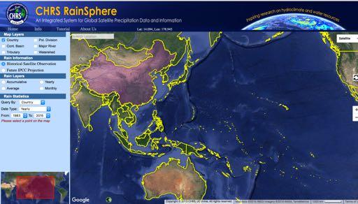


15 CHRS RainSphere
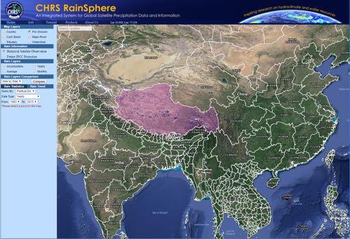

16 CHRS RainSphere Rainsphere.eng.uci.edu


17 CHRS RainSphere Rainsphere.eng.uci.edu Political Major Countries Watersheds Divisions Basins Rainfall Trends Across Spatial Scales
18 How Do we Judge the level of accuracy of PERSIANN-CDR??


19 Regional Evaluations of PERSIANN-CDR Many Regional Evaluation of PERSIANN-CDR Have Already Been Reported: EA PERSIANN-CDR Pixel correlation Scatterplot of mean RR95p 10mmTOT Rain rate (mm/day) R10mm


 More than 2,200 ground-based stations across China 0.")
20 PERSIANN-CDR Evaluation over China ~1 gauge per 25,000 km 2 ~1 gauge per 5,000 km 2 Monsoon region EA Rain Gauge Distribution Elevation Map Dr. Chiyuan Miao - BNU Gauge data: daily precipitation over East Asia (EA) (Xie et al., 2007) More than 2,200 ground-based stations across China 0.5 resolution Period PERSIANN-CDR: up scaled into the same resolution as EA (0.5 o )


21 Results: Entire China EA PERSIANN-CDR Pixel correlation Scatterplot of mean RR95p R10mmTOT R10mm Miao et al., JHM 2015

22 Miao et al., 2015 conclusion About Tibetan Plateau The results show that PERSIANN-CDR depicts similar precipitation behavior as the ground-based EA product in terms of capturing the spatial and temporal patterns of daily precipitation extremes, particularly in the Eastern China monsoon region. However, the agreement between the data sets in the Tibetan Plateau is not strong. An important factor that may have influenced the results is that the groundbased stations are very sparse. Miao et al., 2015


23 PERSIANN-CDR Evaluation in Tibetan Plateau Upper Yangtze River Basin 138,000 km 2 4 Gauges Upper Yellow River Basin 120,000 km 2 11 Gauges The Evaluation was based on the use of a calibrated hydrologic model and using both gauge and PERSIANN-CDR to see which one produced more accurate Streamflow simulation X. Liu T. Yang Liu et al., HESS 2016
24 PERSIANN-CDR Evaluation in Tibetan Plateau Comparisons of the simulated and observed average monthly streamflow driven by the gauge-based precipitation and PERSIANN-CDR precipitation for the two basins from 1983 to Liu et al., HESS 2016

25 PERSIANN Extensions: Weather-Related CHRS irain An Integrated System for Global Real-time Precipitation Observation

26 Capturing Extreme Precipitation from Hurricane Harvey (Aug )
27 How Trust Worthy are Real-Time Satellite Precipitation Estimates??


28


29 Zhongwen Yang

30 Zhongwen Yang et al., 2017 (GRA)

31 Hydrologic Evaluation


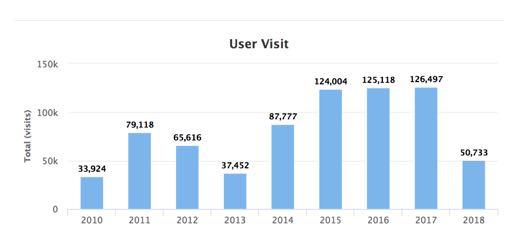
32 Who Uses CHRS Products irain.eng.uci.edu
 were introduced.")
33 Summary Satellite-based precipitation estimates have been evolving and improving in terms of their spatial and temporal resolutions. Two of the PERSIANN products (the Climate-Scale PERSIANN-CDR and the Real-Time high resolution PERSIANN-CCS) were introduced. Results of their evaluations over several watersheds in the Tibetan Plateau were presented. The efficacy of PERSIANN-CDR over two Tibetan watersheds was demonstrated. In the case of the real-time high resolutions PERSIANN- CCS, it is shown that even with limited gauge observations systematic corrections of the remotely sensed estimates improves Center for the Hydrometeorology performance and Remote of Sensing, the University algorithm of California, and Irvine its accuracy


34 Thank You for Listening Somewhere in New Mexico, USA - Photo: J. Sorooshian
35 Evaluation Indices ID Definition Unit RR95p The 95th percentile of annual precipitation on wet days (precipitation 1mm) mm/day R10mmTOT Annual total precipitation when daily precipitation 10mm mm R10mm Annual count of days when precipitation 10mm Days Extreme precipitation indices used in the analysis
Quantitative Precipitation Estimation using Satellite and Ground Measurements
 Quantitative Precipitation Estimation using Satellite and Ground Measurements Kuolin Hsu Center for Hydrometeorology and Remote Sensing University of California Irvine XVII Congress of the Spanish Association
Remote Sensing Applications for Drought Monitoring
 Remote Sensing Applications for Drought Monitoring Amir AghaKouchak Center for Hydrometeorology and Remote Sensing Department of Civil and Environmental Engineering University of California, Irvine Outline
Challenges and Limitations of Hydroclimatological Forecasting and the Relative Role of its Three Pillars: Models, Observations and Parameterization
 Challenges and Limitations of Hydroclimatological Forecasting and the Relative Role of its Three Pillars: Models, Observations and Parameterization Soroosh Sorooshian Center for Hydrometeorology and Remote
Evaluation of the PERSIANN-CDR Daily Rainfall Estimates in Capturing the Behavior of Extreme Precipitation Events over China
 JUNE 2015 M I A O E T A L. 1387 Evaluation of the PERSIANN-CDR Daily Rainfall Estimates in Capturing the Behavior of Extreme Precipitation Events over China CHIYUAN MIAO State Key Laboratory of Earth Surface
2009 Progress Report To The National Aeronautics and Space Administration NASA Energy and Water Cycle Study (NEWS) Program
 Program") 2009 Progress Report To The National Aeronautics and Space Administration NASA Energy and Water Cycle Study (NEWS) Program Proposal Title: Grant Number: PI: The Challenges of Utilizing Satellite Precipitation
2009 Progress Report To The National Aeronautics and Space Administration NASA Energy and Water Cycle Study (NEWS) Program Proposal Title: Grant Number: PI: The Challenges of Utilizing Satellite Precipitation
Director: Soroosh Sorooshian
 Director: Soroosh Sorooshian X. Gao B. Imam K. Hsu S. O Rourke D. Hohnbaum J. Li G.H. Park D. Braithwaite E. Pritchard B. Khakbaz W. Chu A. Behrangi Alex R. Sutlana Joey A. Zahraei Developing state-of-the-art
Remote sensing of precipitation extremes
 The panel is about: Understanding and predicting weather and climate extreme Remote sensing of precipitation extremes Climate extreme : (JSC meeting, June 30 2014) IPCC SREX report (2012): Climate Ali
Evaluation of Satellite Precipitation Products over the Central of Vietnam
 Evaluation of Satellite Precipitation Products over the Central of Vietnam Long Trinh-Tuan (1), Jun Matsumoto (1,2), Thanh Ngo-Duc (3) (1) Department of Geography, Tokyo Metropolitan University, Japan.
School on Modelling Tools and Capacity Building in Climate and Public Health April Remote Sensing
 2453-5 School on Modelling Tools and Capacity Building in Climate and Public Health 15-26 April 2013 Remote Sensing CECCATO Pietro International Research Institute for Climate and Society, IRI The Earth
School on Modelling Tools and Capacity Building in Climate and Public Health April Rainfall Estimation
 2453-6 School on Modelling Tools and Capacity Building in Climate and Public Health 15-26 April 2013 Rainfall Estimation CECCATO Pietro International Research Institute for Climate and Society, IRI The
Satellite derived precipitation estimates over Indian region during southwest monsoons
 J. Ind. Geophys. Union ( January 2013 ) Vol.17, No.1, pp. 65-74 Satellite derived precipitation estimates over Indian region during southwest monsoons Harvir Singh 1,* and O.P. Singh 2 1 National Centre
The Global Precipitation Climatology Project (GPCP) CDR AT NOAA: Research to Real-time Climate Monitoring
 CDR AT NOAA: Research to Real-time Climate Monitoring") The Global Precipitation Climatology Project (GPCP) CDR AT NOAA: Research to Real-time Climate Monitoring Robert Adler, Matt Sapiano, Guojun Gu University of Maryland Pingping Xie (NCEP/CPC), George Huffman
The Global Precipitation Climatology Project (GPCP) CDR AT NOAA: Research to Real-time Climate Monitoring Robert Adler, Matt Sapiano, Guojun Gu University of Maryland Pingping Xie (NCEP/CPC), George Huffman
Global Precipitation Data Sets
 Global Precipitation Data Sets Rick Lawford (with thanks to Phil Arkin, Scott Curtis, Kit Szeto, Ron Stewart, etc) April 30, 2009 Toronto Roles of global precipitation products in drought studies: 1.Understanding
P4.4 THE COMBINATION OF A PASSIVE MICROWAVE BASED SATELLITE RAINFALL ESTIMATION ALGORITHM WITH AN IR BASED ALGORITHM
 P4.4 THE COMBINATION OF A PASSIVE MICROWAVE BASED SATELLITE RAINFALL ESTIMATION ALGORITHM WITH AN IR BASED ALGORITHM Robert Joyce 1), John E. Janowiak 2), and Phillip A. Arkin 3, Pingping Xie 2) 1) RS
TRMM Multi-satellite Precipitation Analysis (TMPA)
") TRMM Multi-satellite Precipitation Analysis (TMPA) (sometimes known as 3B42/43, TRMM product numbers) R. Adler, G. Huffman, D. Bolvin, E. Nelkin, D. Wolff NASA/Goddard Laboratory for Atmospheres with key
TRMM Multi-satellite Precipitation Analysis (TMPA) (sometimes known as 3B42/43, TRMM product numbers) R. Adler, G. Huffman, D. Bolvin, E. Nelkin, D. Wolff NASA/Goddard Laboratory for Atmospheres with key
Operational quantitative precipitation estimation using radar, gauge g and
 Operational quantitative precipitation estimation using radar, gauge g and satellite for hydrometeorological applications in Southern Brazil Leonardo Calvetti¹, Cesar Beneti¹, Diogo Stringari¹, i¹ Alex
Basins-Level Heavy Rainfall and Flood Analyses
 Basins-Level Heavy Rainfall and Flood Analyses Peng Gao, Greg Carbone, and Junyu Lu Department of Geography, University of South Carolina (gaop@mailbox.sc.edu, carbone@mailbox.sc.edu, jlu@email.sc.edu)
The challenge of predicting flash floods from thunderstorm rainfall
 10.1098/rsta.2002.1015 The challenge of predicting flash floods from thunderstorm rainfall By Hosin Gupta, Soroosh Sorooshian, Xiaogang Gao, Bisher Imam, Kuo-Lin Hsu, Luis Bastidas, Jailun Li and Shayesteh
Evaluation of the Version 7 TRMM Multi-Satellite Precipitation Analysis (TMPA) 3B42 product over Greece
 3B42 product over Greece") 15 th International Conference on Environmental Science and Technology Rhodes, Greece, 31 August to 2 September 2017 Evaluation of the Version 7 TRMM Multi-Satellite Precipitation Analysis (TMPA) 3B42
15 th International Conference on Environmental Science and Technology Rhodes, Greece, 31 August to 2 September 2017 Evaluation of the Version 7 TRMM Multi-Satellite Precipitation Analysis (TMPA) 3B42
Abebe Sine Gebregiorgis, PhD Postdoc researcher. University of Oklahoma School of Civil Engineering and Environmental Science
 Abebe Sine Gebregiorgis, PhD Postdoc researcher University of Oklahoma School of Civil Engineering and Environmental Science November, 2014 MAKING SATELLITE PRECIPITATION PRODUCTS WORK FOR HYDROLOGIC APPLICATION
Uncertainty quantification of satellite precipitation estimation and Monte Carlo assessment of the error propagation into hydrologic response
 Click Here for Full Article WATER RESOURCES RESEARCH, VOL. 42,, doi:10.1029/2005wr004398, 2006 Uncertainty quantification of satellite precipitation estimation and Monte Carlo assessment of the error propagation
High resolution spatiotemporal distribution of rainfall seasonality and extreme events based on a 12-year TRMM time series
 High resolution spatiotemporal distribution of rainfall seasonality and extreme events based on a 12-year TRMM time series Bodo Bookhagen, Geography Department, UC Santa Barbara, Santa Barbara, CA 93106-4060
Performance of high-resolution satellite precipitation products over China
 Click Here for Full Article JOURNAL OF GEOPHYSICAL RESEARCH, VOL. 115,, doi:10.1029/2009jd012097, 2010 Performance of high-resolution satellite precipitation products over China Yan Shen, 1 Anyuan Xiong,
Mingyue Chen 1)* Pingping Xie 2) John E. Janowiak 2) Vernon E. Kousky 2) 1) RS Information Systems, INC. 2) Climate Prediction Center/NCEP/NOAA
* Pingping Xie 2) John E. Janowiak 2) Vernon E. Kousky 2) 1) RS Information Systems, INC. 2) Climate Prediction Center/NCEP/NOAA") J3.9 Orographic Enhancements in Precipitation: Construction of a Global Monthly Precipitation Climatology from Gauge Observations and Satellite Estimates Mingyue Chen 1)* Pingping Xie 2) John E. Janowiak
J3.9 Orographic Enhancements in Precipitation: Construction of a Global Monthly Precipitation Climatology from Gauge Observations and Satellite Estimates Mingyue Chen 1)* Pingping Xie 2) John E. Janowiak
Global Flood Alert System based on satellite derived rainfall data -Targeting the era of Global Precipitation Measurement (GPM)-
-") Global Flood Alert System based on satellite derived rainfall data -Targeting the era of Global Precipitation Measurement (GPM)- Riko Oki, Misako Kachi (JAXA/EORC) Kazuhiko Fukami (PWRI) and Kazuo Umeda
Global Flood Alert System based on satellite derived rainfall data -Targeting the era of Global Precipitation Measurement (GPM)- Riko Oki, Misako Kachi (JAXA/EORC) Kazuhiko Fukami (PWRI) and Kazuo Umeda
Spati-temporal Changes of NDVI and Their Relations with Precipitation and Temperature in Yangtze River Catchment from 1992 to 2001
 Spati-temporal Changes of NDVI and Their Relations with Precipitation and Temperature in Yangtze River Catchment from 1992 to 2001 ZHANG Li 1, CHEN Xiao-Ling 1, 2 1State Key Laboratory of Information Engineering
GPM-GSMaP data is now available from JAXA G-portal (https://www.gportal.jaxa.jp) as well as current GSMaP web site (http://sharaku.eorc.jaxa.
 as well as current GSMaP web site (http://sharaku.eorc.jaxa.") GPM-GSMaP data is now available from JAXA G-portal (https://www.gportal.jaxa.jp) as well as current GSMaP web site (http://sharaku.eorc.jaxa.jp/ GSMaP/). GPM Core GMI TRMM PR GPM era Precipitation Radar
GPM-GSMaP data is now available from JAXA G-portal (https://www.gportal.jaxa.jp) as well as current GSMaP web site (http://sharaku.eorc.jaxa.jp/ GSMaP/). GPM Core GMI TRMM PR GPM era Precipitation Radar
DIURNAL VARIATION OF SUMMER RAINFALL OVER THE TIBETAN PLATEAU AND ITS NEIGHBORING REGIONS REVEALED BY TRMM MULTI-SATELLITE PRECIPITATION ANALYSIS
 CHINESE JOURNAL OF GEOPHYSICS Vol.51, No.3, 2008, pp: 518 529 DIURNAL VARIATION OF SUMMER RAINFALL OVER THE TIBETAN PLATEAU AND ITS NEIGHBORING REGIONS REVEALED BY TRMM MULTI-SATELLITE PRECIPITATION ANALYSIS
Eighteenth International Water Technology Conference, IWTC18 Sharm ElSheikh, March 2015
 SPATIOTEMPORAL EVALUATION OF GLOBAL PRECIPITATION MAPPING -GSMAP AT BASIN SCALE IN SAGAMI RIVER, JAPAN S. Takegawa 1, K. Takido 2, ando. Saavedra 3 1 Tokyo Institute of Technology, Tokyo,koizumi.s.ae@m.titech.ac.jp
Retrieval of precipitation from Meteosat-SEVIRI geostationary satellite observations
 Retrieval of precipitation from Meteosat-SEVIRI geostationary satellite observations Jan Fokke Meirink, Hidde Leijnse (KNMI) Rob Roebeling (EUMETSAT) Overview Introduction Algorithm description Validation
Precipitation Estimation from Remotely Sensed Imagery Using an Artificial Neural Network Cloud Classification System
 1834 JOURNAL OF APPLIED METEOROLOGY Precipitation Estimation from Remotely Sensed Imagery Using an Artificial Neural Network Cloud Classification System YANG HONG Department of Hydrology and Water Resources,
DERIVED FROM SATELLITE DATA
 P6.17 INTERCOMPARISON AND DIAGNOSIS OF MEI-YU RAINFALL DERIVED FROM SATELLITE DATA Y. Zhou * Department of Meteorology, University of Maryland, College Park, Maryland P. A. Arkin ESSIC, University of Maryland,
Application of Satellite Data for Flood Forecasting and Early Warning in the Mekong River Basin in South-east Asia
 MEKONG RIVER COMMISSION Vientiane, Lao PDR Application of Satellite Data for Flood Forecasting and Early Warning in the Mekong River Basin in South-east Asia 4 th World Water Forum March 2006 Mexico City,
REFAME: Rain Estimation Using Forward-Adjusted Advection of Microwave Estimates
 DECEMBER 2010 B E H R A N G I E T A L. 1305 REFAME: Rain Estimation Using Forward-Adjusted Advection of Microwave Estimates ALI BEHRANGI,* BISHER IMAM, KUOLIN HSU, AND SOROOSH SOROOSHIAN Center for Hydrometeorology
Author response to reviewer s comments
 Author response to reviewer s comments On behalf of myself and the co-authors, I take the opportunity to thank the anonymous reviewers for his/her constructive comments, questions and editions. We have
Eight Years of TRMM Data: Understanding Regional Mechanisms Behind the Diurnal Cycle
 Eight Years of TRMM Data: Understanding Regional Mechanisms Behind the Diurnal Cycle Steve Nesbitt, Rob Cifelli, Steve Rutledge Colorado State University Chuntao Liu, Ed Zipser University of Utah Funding
A conceptual model for constructing high resolution gauge satellite merged precipitation analyses
 JOURNAL OF GEOPHYSICAL RESEARCH, VOL. 116,, doi:10.1029/2011jd016118, 2011 A conceptual model for constructing high resolution gauge satellite merged precipitation analyses Pingping Xie 1 and An Yuan Xiong
THE EUMETSAT MULTI-SENSOR PRECIPITATION ESTIMATE (MPE)
") THE EUMETSAT MULTI-SENSOR PRECIPITATION ESTIMATE (MPE) Thomas Heinemann, Alessio Lattanzio and Fausto Roveda EUMETSAT Am Kavalleriesand 31, 64295 Darmstadt, Germany ABSTRACT The combination of measurements
THE EUMETSAT MULTI-SENSOR PRECIPITATION ESTIMATE (MPE) Thomas Heinemann, Alessio Lattanzio and Fausto Roveda EUMETSAT Am Kavalleriesand 31, 64295 Darmstadt, Germany ABSTRACT The combination of measurements
Snowfall Detection and Rate Retrieval from ATMS
 Snowfall Detection and Rate Retrieval from ATMS Jun Dong 1, Huan Meng 2, Cezar Kongoli 1, Ralph Ferraro 2, Banghua Yan 2, Nai-Yu Wang 1, Bradley Zavodsky 3 1 University of Maryland/ESSIC/Cooperative Institute
Asian Precipitation -- Highly Resolved Observational Data Integration Towards Evaluation of the Water Resources (APHRODITE s Water Resources)
") PHERPP Meeting (3-5December 2007) WMO (Geneva) Asian Precipitation -- Highly Resolved Observational Data Integration Towards Evaluation of the Water Resources (APHRODITE s Water Resources) Akiyo Yatagai
PHERPP Meeting (3-5December 2007) WMO (Geneva) Asian Precipitation -- Highly Resolved Observational Data Integration Towards Evaluation of the Water Resources (APHRODITE s Water Resources) Akiyo Yatagai
Evaluation of GPM Precipitation Estimates for Land Data Assimilation Applications
 Evaluation of GPM Precipitation Estimates for Land Data Assimilation Applications PI: Prof. Lori Bruce, Ph.D Mississippi State University GeoResources Institute RPC Review (04/14/08) 1 GPM Evaluation Team
Remote Sensing of Snow and Ice. Lecture 21 Nov. 9, 2005
 Remote Sensing of Snow and Ice Lecture 21 Nov. 9, 2005 Topics Remote sensing snow depth: passive microwave (covered in Lecture 14) Remote sensing sea ice and ice sheet elevation change: Lidar - ICESat
MAIN ATTRIBUTES OF THE PRECIPITATION PRODUCTS DEVELOPED BY THE HYDROLOGY SAF PROJECT RESULTS OF THE VALIDATION IN HUNGARY
 MAIN ATTRIBUTES OF THE PRECIPITATION PRODUCTS DEVELOPED BY THE HYDROLOGY SAF PROJECT RESULTS OF THE VALIDATION IN HUNGARY Eszter Lábó OMSZ-Hungarian Meteorological Service, Budapest, Hungary labo.e@met.hu
Intermittency in precipitation: duration, frequency, intensity and amounts using hourly data
 Intermittency in precipitation: duration, frequency, intensity and amounts using hourly data Kevin E Trenberth with Yongxin Zhang and Maria Gehne NCAR How should rainfall change as climate changes? Usually
THE EVALUATION OF A PASSIVE MICROWAVE-BASED SATELLITE RAINFALL ESTIMATION ALGORITHM WITH AN IR BASED ALGORITHM AT SHORT TIME SCALES
 THE EVALUATION OF A PASSIVE MICROWAVE-BASED SATELLITE RAINFALL ESTIMATION ALGORITHM WITH AN IR BASED ALGORITHM AT SHORT TIME SCALES Robert Joyce 1, John E. Janowiak 2, Phillip A. Arkin 3, Pingping Xie
Satellite and gauge rainfall merging using geographically weighted regression
 132 Remote Sensing and GIS for Hydrology and Water Resources (IAHS Publ. 368, 2015) (Proceedings RSHS14 and ICGRHWE14, Guangzhou, China, August 2014). Satellite and gauge rainfall merging using geographically
Assessing the Applicability of CHELSA (Climatologies at
 International Conference Terrestrial Systems Research: Monitoring, Prediction and High Performance Computing April 4th-6th, 2018, Bonn, Germany Assessing the Applicability of CHELSA (Climatologies at High
H-SAF future developments on Convective Precipitation Retrieval
 H-SAF future developments on Convective Precipitation Retrieval Francesco Zauli 1, Daniele Biron 1, Davide Melfi 1, Antonio Vocino 1, Massimiliano Sist 2, Michele De Rosa 2, Matteo Picchiani 2, De Leonibus
COMBINATION OF SATELLITE PRECIPITATION ESTIMATES AND RAIN GAUGE FOR HIGH SPATIAL AND TEMPORAL RESOLUTIONS INTRODUCTION
 COMBINATION OF SATELLITE PRECIPITATION ESTIMATES AND RAIN GAUGE FOR HIGH SPATIAL AND TEMPORAL RESOLUTIONS Ferreira, Rute Costa¹ ; Herdies, D. L.¹; Vila, D.A.¹; Beneti, C.A. A.² ¹ Center for Weather Forecasts
A Prototype Precipitation Retrieval Algorithm Over Land for SSMIS and ATMS
 A Prototype Precipitation Retrieval Algorithm Over Land for SSMIS and ATMS Yalei You 1, Nai-Yu Wang 2, Ralph Ferraro 2 1 CICS-MD/ESSIC/UMD 2 STAR/NESDIS/NOAA Background Our group provided the level-2 rainfall
CHAPTER VII COMPARISON OF SATELLITE (TRMM) PRECIPITATION DATA WITH GROUND-BASED DATA
 PRECIPITATION DATA WITH GROUND-BASED DATA") CHAPTER VII COMPARISON OF SATELLITE () PRECIPITATION DATA WITH GROUND-BASED DATA CHAPTER VII COMPARISON OF SATELLITE () PRECIPITATION DATA WITH GROUND-BASED DATA 7.1. INTRODUCTION Most of the earth s rain
CHAPTER VII COMPARISON OF SATELLITE () PRECIPITATION DATA WITH GROUND-BASED DATA CHAPTER VII COMPARISON OF SATELLITE () PRECIPITATION DATA WITH GROUND-BASED DATA 7.1. INTRODUCTION Most of the earth s rain
Modeling rainfall diurnal variation of the North American monsoon core using different spatial resolutions
 Modeling rainfall diurnal variation of the North American monsoon core using different spatial resolutions Jialun Li, X. Gao, K.-L. Hsu, B. Imam, and S. Sorooshian Department of Civil and Environmental
Evaluation of latest TMPA and CMORPH satellite precipitation products over Yellow River Basin
 Water Science and Engineering 2016, 9(2): 87e96 HOSTED BY Available online at www.sciencedirect.com Water Science and Engineering journal homepage: http://www.waterjournal.cn Evaluation of latest TMPA
AMS copyrighted work
 AMS copyrighted work Copyright 2014 American Meteorological Society (AMS). Permission to use figures, tables, and brief excerpts from this work in scientific and educational works is hereby granted provided
Spaceborne and Ground-based Global and Regional Precipitation Estimation: Multi-Sensor Synergy
 Hydrometeorology and Remote Sensing Lab (hydro.ou.edu) at The University of Oklahoma Spaceborne and Ground-based Global and Regional Precipitation Estimation: Multi-Sensor Synergy Presented by: 温逸馨 (Berry)
Multiple data fusion for rainfall estimation using a NARX-based recurrent neural network the development of the REIINN model
 IOP Conference Series: Earth and Environmental Science OPEN ACCESS Multiple data fusion for rainfall estimation using a NARX-based recurrent neural network the development of the REIINN model To cite this
Spatial Downscaling of TRMM Precipitation Using DEM. and NDVI in the Yarlung Zangbo River Basin
 Spatial Downscaling of TRMM Precipitation Using DEM and NDVI in the Yarlung Zangbo River Basin Yang Lu 1,2, Mingyong Cai 1,2, Qiuwen Zhou 1,2, Shengtian Yang 1,2 1 State Key Laboratory of Remote Sensing
INTERNATIONAL PRECIPITATION WORKING GROUP (IPWG): INTER-COMPARISON OF REGIONAL PRECIPITATION PRODUCTS
: INTER-COMPARISON OF REGIONAL PRECIPITATION PRODUCTS") INTERNATIONAL PRECIPITATION WORKING GROUP (IPWG): INTER-COMPARISON OF REGIONAL PRECIPITATION PRODUCTS Kidd C 1, Heinemann T 2, Levizzani V 3, and Kniveton D.R 4. 1 School of Geography, Earth and Environmental
INTERNATIONAL PRECIPITATION WORKING GROUP (IPWG): INTER-COMPARISON OF REGIONAL PRECIPITATION PRODUCTS Kidd C 1, Heinemann T 2, Levizzani V 3, and Kniveton D.R 4. 1 School of Geography, Earth and Environmental
Assessment of ERA-20C reanalysis monthly precipitation totals on the basis of GPCC in-situ measurements
 Assessment of ERA-20C reanalysis monthly precipitation totals on the basis of GPCC in-situ measurements Elke Rustemeier, Markus Ziese, Andreas Becker, Anja Meyer-Christoffer, Udo Schneider, and Peter Finger
A High Resolution Daily Gridded Rainfall Data Set ( ) for Mesoscale Meteorological Studies
 for Mesoscale Meteorological Studies") National Climate Centre Research Report No: 9/2008 A High Resolution Daily Gridded Rainfall Data Set (1971-2005) for Mesoscale Meteorological Studies M. Rajeevan and Jyoti Bhate National Climate Centre
National Climate Centre Research Report No: 9/2008 A High Resolution Daily Gridded Rainfall Data Set (1971-2005) for Mesoscale Meteorological Studies M. Rajeevan and Jyoti Bhate National Climate Centre
A Statistical Model for the Uncertainty Analysis of Satellite Precipitation Products
 OCTOBER 2015 S A R A C H I E T A L. 2101 A Statistical Model for the Uncertainty Analysis of Satellite Precipitation Products SEPIDEH SARACHI, KUO-LIN HSU, AND SOROOSH SOROOSHIAN Center for Hydrometeorology
State of the art of satellite rainfall estimation
 State of the art of satellite rainfall estimation 3-year comparison over South America using gauge data, and estimates from IR, TRMM radar and passive microwave Edward J. Zipser University of Utah, USA
The role of the Himalaya and the Tibetan Plateau for the Indian Monsoon
 June, 7 th June, 14 th 2009 The role of the Himalaya and the Tibetan Plateau for the Indian Monsoon Prof. Dr. Klaus Dethloff (AWI Potsdam) Stefan Polanski (AWI Potsdam 2008-2010) Dr. Annette Rinke (AWI
Remote Sensing of Precipitation on the Tibetan Plateau Using the TRMM Microwave Imager
 AUGUST 2001 YAO ET AL. 1381 Remote Sensing of Precipitation on the Tibetan Plateau Using the TRMM Microwave Imager ZHANYU YAO Laboratory for Severe Storm Research, Department of Geophysics, Peking University,
NASA Flood Monitoring and Mapping Tools
 National Aeronautics and Space Administration ARSET Applied Remote Sensing Training http://arset.gsfc.nasa.gov @NASAARSET NASA Flood Monitoring and Mapping Tools www.nasa.gov Outline Overview of Flood
Decrease of light rain events in summer associated with a warming environment in China during
 GEOPHYSICAL RESEARCH LETTERS, VOL. 34, L11705, doi:10.1029/2007gl029631, 2007 Decrease of light rain events in summer associated with a warming environment in China during 1961 2005 Weihong Qian, 1 Jiaolan
Influence of rainfall space-time variability over the Ouémé basin in Benin
 102 Remote Sensing and GIS for Hydrology and Water Resources (IAHS Publ. 368, 2015) (Proceedings RSHS14 and ICGRHWE14, Guangzhou, China, August 2014). Influence of rainfall space-time variability over
Applications of yield monitoring systems and agricultural statistics in agricultural (re)insurance
insurance") Image: used under license from shutterstock.com Applications of yield monitoring systems and agricultural statistics in agricultural (re)insurance 18 October 2018 Ernst Bedacht Agenda Introduction 1. Munich
Image: used under license from shutterstock.com Applications of yield monitoring systems and agricultural statistics in agricultural (re)insurance 18 October 2018 Ernst Bedacht Agenda Introduction 1. Munich
Hurricane Floyd Symposium. Satellite Precipitation as a Tool to Reanalyze Hurricane Floyd and Forecast Probabilities of Extreme Rainfall
 Sept. 18, 2009 Hurricane Floyd Symposium Scott Curtis, East Carolina Universtiy Satellite Precipitation as a Tool to Reanalyze Hurricane Floyd and Forecast Probabilities of Extreme Rainfall What was the
Moving Freshwater to the Ocean: Hydrology-Ocean Model Coupling
 Moving Freshwater to the Ocean: Hydrology-Ocean Model Coupling Cheryl Ann Blain 1, Tim Campbell 1, Song Yang 2, Aubrey Dugger 3, Paul Martin 1, Tommy Jenson 1 Naval Research Laboratory 1 Oceanography Division,
Japanese Programs on Space and Water Applications
 Japanese Programs on Space and Water Applications Tamotsu IGARASHI Remote Sensing Technology Center of Japan June 2006 COPUOS 2006 Vienna International Centre Water-related hazards/disasters may occur
Simulation of sedimentation rates using the SWAT model A case study of the Tarbela Dam, Upper Indus Basin
 Simulation of sedimentation rates using the SWAT model A case study of the Tarbela Dam, Upper Indus Basin Ahammad, H. I 1., Crosato A 2,3., Maskey, S 2., Masih, I 2,*, McClain, M 2. 1 Punjab Irrigation
CLOUD PATCH-BASED RAINFALL ESTIMATION USING A SATELLITE IMAGE CLASSIFICATION APPROACH
 CLOUD PATCH-BASED RAINFALL ESTIMATION USING A SATELLITE IMAGE CLASSIFICATION APPROACH Yang Hong, Kuo-lin Hsu, and Soroosh Sorooshian Center for Hydrometeorology and Remote Sensing, Department of Civil
Performance of High Resolution Satellite Rainfall Products over Data Scarce Parts of Eastern Ethiopia
 Florida International University FIU Digital Commons Department of Earth and Environment College of Arts, Sciences & Education 9-11-2015 Performance of High Resolution Satellite Rainfall Products over
Overview and Access to GPCP, TRMM, and GPM Precipitation Data Products
 National Aeronautics and Space Administration ARSET Applied Remote Sensing Training http://arset.gsfc.nasa.gov @NASAARSET Overview and Access to GPCP, TRMM, and GPM Precipitation Data Products www.nasa.gov
Tracing hydrologic model simulation error as a function of satellite rainfall estimation bias components and land use and land cover conditions
 University of Nebraska - Lincoln DigitalCommons@University of Nebraska - Lincoln NASA Publications National Aeronautics and Space Administration 2012 Tracing hydrologic model simulation error as a function
Comparison of Diurnal Variation of Precipitation System Observed by TRMM PR, TMI and VIRS
 Comparison of Diurnal Variation of Precipitation System Observed by TRMM PR, TMI and VIRS Munehisa K. Yamamoto, Fumie A. Furuzawa 2,3 and Kenji Nakamura 3 : Graduate School of Environmental Studies, Nagoya
LMODEL: A Satellite Precipitation Methodology Using Cloud Development Modeling. Part II: Validation
 1096 J O U R N A L O F H Y D R O M E T E O R O L O G Y VOLUME 10 LMODEL: A Satellite Precipitation Methodology Using Cloud Development Modeling. Part II: Validation KUO-LIN HSU University of California,
VERIFICATION OF APHRODITE PRECIPITATION DATA SETS OVER BANGLADESH
 Proceedings of the 4 th International Conference on Civil Engineering for Sustainable Development (ICCESD 2018), 9~11 February 2018, KUET, Khulna, Bangladesh (ISB-978-984-34-3502-6) VERIFICATIO OF APHRODITE
Comparison of satellite rainfall estimates with raingauge data for Africa
 Comparison of satellite rainfall estimates with raingauge data for Africa David Grimes TAMSAT Acknowledgements Ross Maidment Teo Chee Kiat Gulilat Tefera Diro TAMSAT = Tropical Applications of Meteorology
Analyzing and Visualizing Precipitation and Soil Moisture in ArcGIS
 Analyzing and Visualizing Precipitation and Soil Moisture in ArcGIS Wenli Yang, Pham Long, Peisheng Zhao, Steve Kempler, and Jennifer Wei * NASA Goddard Earth Science Data and Information Services Center
DEVELOPMENT OF A LARGE-SCALE HYDROLOGIC PREDICTION SYSTEM
 JP3.18 DEVELOPMENT OF A LARGE-SCALE HYDROLOGIC PREDICTION SYSTEM Ji Chen and John Roads University of California, San Diego, California ABSTRACT The Scripps ECPC (Experimental Climate Prediction Center)
P8.4 VALIDATION OF HYDRO-ESTIMATOR AND NEXRAD OVER PUERTO RICO
 P8.4 VALIDATION OF HYDRO-ESTIMATOR AND NEXRAD OVER PUERTO RICO Nazario D. Ramirez-Beltran 1*,Robert J. Kuligowski 2, Eric Harmsen 1, Sandra Cruz-Pol 1, Joan M. Castro 1, and Israel Matos 3 University of
Climate Impacts to Southwest Water Sector. Dr. Dave DuBois New Mexico State Climatologist
 Climate Impacts to Southwest Water Sector Dr. Dave DuBois New Mexico State Climatologist Presented at EPA Extreme Events and Climate Adaptation Planning Workshop June 3, 2015 Water Year Precip. % of Average
The North American Drought Monitor - The Canadian Perspective -
 The North American Drought Monitor - The Canadian Perspective - Trevor Hadwen National Agroclimate Information Service AAFC-PFRA, Regina Canmore, Alberta March 16-18, 2008 Background The NADM is a cooperative
The Importance of Snowmelt Runoff Modeling for Sustainable Development and Disaster Prevention
 The Importance of Snowmelt Runoff Modeling for Sustainable Development and Disaster Prevention Muzafar Malikov Space Research Centre Academy of Sciences Republic of Uzbekistan Water H 2 O Gas - Water Vapor
Validation of Satellite-Based PERSIANN Rainfall Estimates Using Surface-Based APHRODITE Data over Iran
 Earth Sciences 2015; 4(5): 150-160 Published online September 2, 2015 (http://www.sciencepublishinggroup.com/j/earth) doi: 10.11648/j.earth.20150405.11 ISSN: 2328-5974 (Print); ISSN: 2328-5982 (Online)
Land Data Assimilation at NCEP NLDAS Project Overview, ECMWF HEPEX 2004
 Dag.Lohmann@noaa.gov, Land Data Assimilation at NCEP NLDAS Project Overview, ECMWF HEPEX 2004 Land Data Assimilation at NCEP: Strategic Lessons Learned from the North American Land Data Assimilation System
Generating Multi-Sensor Precipitation Estimates over Radar Gap Areas
 Generating Multi-Sensor Precipitation Estimates over Radar Gap Areas SHAYESTEH E. MAHANI and REZA KHANBILVARDI Civil Engineering Department City University of New York (CUNY) & Cooperative Remote Sensing
National Weather Service Flood Forecast Needs: Improved Rainfall Estimates
 National Weather Service Flood Forecast Needs: Improved Rainfall Estimates Weather Forecast Offices Cleveland and Northern Indiana Ohio River Forecast Center Presenter: Sarah Jamison, Service Hydrologist
A PARAMETER ESTIMATE FOR THE LAND SURFACE MODEL VIC WITH HORTON AND DUNNE RUNOFF MECHANISM FOR RIVER BASINS IN CHINA
 A PARAMETER ESTIMATE FOR THE LAND SURFACE MODEL VIC WITH HORTON AND DUNNE RUNOFF MECHANISM FOR RIVER BASINS IN CHINA ZHENGHUI XIE Institute of Atmospheric Physics, Chinese Academy of Sciences Beijing,
Assessing the performance of satellite-based precipitation products and its dependence on topography over Poyang Lake basin
 Theor Appl Climatol (2014) 115:713 729 DOI 10.1007/s00704-013-0917-x ORIGINAL PAPER Assessing the performance of satellite-based precipitation products and its dependence on topography over Poyang Lake
GSMaP - Integrated application with developer and user collaboration -
 WIGOS WORKSHOP 2019 Session 2.2 GSMaP - Integrated application with developer and user collaboration - Takuji Kubota and Moeka Yamaji Earth Observation Research Center (EORC) Japan Aerospace Exploration
Chiang Rai Province CC Threat overview AAS1109 Mekong ARCC
 Chiang Rai Province CC Threat overview AAS1109 Mekong ARCC This threat overview relies on projections of future climate change in the Mekong Basin for the period 2045-2069 compared to a baseline of 1980-2005.
ME KONG RIVER COMMISSION FLASH FLOOD GUIDANCE SYSTEM (MRCFFGS)
") NATIONAL HYDRO-METEOROLOGICAL SERVICE IN VIETNAM NATIONAL CENTER FOR HYDRO-METEOROLOGICAL FORECASTING ME KONG RIVER COMMISSION FLASH FLOOD GUIDANCE SYSTEM (MRCFFGS) http://www.nchmf.gov.vn 29 Nov 1 Dec
NATIONAL HYDRO-METEOROLOGICAL SERVICE IN VIETNAM NATIONAL CENTER FOR HYDRO-METEOROLOGICAL FORECASTING ME KONG RIVER COMMISSION FLASH FLOOD GUIDANCE SYSTEM (MRCFFGS) http://www.nchmf.gov.vn 29 Nov 1 Dec
Rainfall Estimation Models Induced from Ground Station and Satellite Data
 Rainfall Estimation Models Induced from Ground Station and Satellite Data Kittisak Kerdprasop and Nittaya Kerdprasop Abstract Rainfall is an important source of water in agricultural sector of Thailand
BSYSE 456/556 Surface Hydrologic Processes and Modeling
 BSYSE 456/556 Surface Hydrologic Processes and Modeling Lab 9 (Prepared by Erin Brooks and Jan Boll, UI, and Joan Wu, WSU) P Introduction One of the most difficult tasks in watershed assessment and management
WATER RESOURCES RESEARCH, VOL. 46, W07542, doi: /2009wr008965, 2010
 Click Here for Full Article WATER RESOURCES RESEARCH, VOL. 46,, doi:10.1029/2009wr008965, 2010 Hydrologic evaluation of Multisatellite Precipitation Analysis standard precipitation products in basins beyond
Climate Prediction Center National Centers for Environmental Prediction
 NOAA s Climate Prediction Center Climate Monitoring Tool Wassila M. Thiaw and CPC International Team Climate Prediction Center National Centers for Environmental Prediction CPC International Team Vadlamani
Haiti-Dominican Republic Flash Flood Guidance (HDRFFG) System: Development of System Products
 System: Development of System Products") Haiti-Dominican Republic Flash Flood Guidance (HDRFFG) System: Development of System Products Theresa M. Modrick, PhD Hydrologic Research Center HDRFFG Initial Planning Meeting 07-09 Sep 2015 Santo Domingo,
Haiti-Dominican Republic Flash Flood Guidance (HDRFFG) System: Development of System Products Theresa M. Modrick, PhD Hydrologic Research Center HDRFFG Initial Planning Meeting 07-09 Sep 2015 Santo Domingo,