Evaluation of GPM Precipitation Estimates for Land Data Assimilation Applications
|
|
|
- Cordelia Ferguson
- 5 years ago
- Views:
Transcription
1 Evaluation of GPM Precipitation Estimates for Land Data Assimilation Applications PI: Prof. Lori Bruce, Ph.D Mississippi State University GeoResources Institute RPC Review (04/14/08) 1
2 GPM Evaluation Team & Collaborators MSU Team Lori Mann Bruce Valentine Anantharaj Georgy Mostovoy Yangrong Ling QiQi Lu Louis Wasson Graduate students External Collaborators Paul Houser (GMU CREW) Joe Turk (Naval Research Laboratories, Monterey, CA) Partner Agencies Garry Schaeffer (USDA NRCS) Steve Hunter (United States Bureau of Reclamation) RPC Review (04/14/08) 2
3 Team Activity MSU GRI: Precipitation evaluation, numerical modeling, project management, RPC Integration. NRL: GPM data, precipitation evaluation. GMU CREW: LSM data assimilation, precipitation evaluation, and science expertise. RPC Review (04/14/08) 3
4 Anticipated Societal Benefits 1. provides critical information to support drought monitoring and mitigation 2. provides essential information for predicting droughts based on weather and climate predictions 3. supports irrigation water management 4. supports fire risk assessment 5. supports water supply forecasting and NWS flood forecasting 6. supplies a critical missing component to assist with snow, climate and associated hydrometeorological data analysis 7. supports climate change assessment 8. enables water quality monitoring 9. supports a wide variety of natural resource management & research activities such as NASA remote sensing activities of soil moisture and ARS watershed studies. RPC Review (04/14/08) 4
5 Precipitation Specifications Depends upon Application Requirements Monthly average rainfall, global (±60o latitude), pentad-type (e.g. 2.5-degree boxes), over land/ocean (Climatic shifts? Desertification?) Accumulated rainfall and snowpack, many stations over a watershed (When do I release water from a reservoir? Allocate water distribution?) ib ti Realtime global or regional analysis of rainrate at the best possible horizontal resolution (hydrological models) 5-minute updates of point rainfall inside an area (e.g., 105 km2) during the lifetime of a thunderstorm or landfalling hurricane away from coastal radars (Should coastal or low-lying areas be evacuated? Temporarily relocate naval fleet to safe harbor?) Any indications that this winter is associated with El Nino conditions? (An energy company, a tree removal company, emergency services) RPC Review (04/14/08) 5
6 GPM Evaluations: Purpose and Activities RPC Review (04/14/08) 6
7 Purpose of RPC GPM Experiments Evaluate usefulness of GPM data for decision support in water resources management and other cross-cutting applications. Test, characterize, and evaluate GPM data in conjunction with other precipitation products in the context of land surface modeling for earth science applications. RPC Review (04/14/08) 7
8 Experimental Objectives of GPM Evaluation 1. Validate space-based precipitation estimation using ground-based d radar and rain gauge data for different cases representing different synoptic condition and surface types 2. Run land surface model experiments to produce water and energy fluxes at 1-10 km resolutions in selected domains, for use in precipitation product evaluation, and subsequent science and application use. 3. Identify water resources applications and metrics to optimize. 4. Define basic standards for error analyses and data quality control by cross correlating the various inputs to the hydrological models. RPC Review (04/14/08) 8


9 Tasks to Achieve Objectives Precipitation Data Processing GPM Proxy data Gage analysis, NEXRAD, other satellite estimates Precipitation it ti Evaluation Technique development Statistical analysis Intra-satellite Sensitivity Analysis Hydrological Modeling Control runs (gage and NEXRAD) Model sensitivity to different precipitation forcings. Analyze results and publish RPC Review (04/14/08) 9
10 GPM Proxy Data RPC Review (04/14/08) 10
11 Multi-Satellite Blending/Merging Techniques for Rapid-Update Precipitation (slides from NRL, NASA, NOAA and other GPM stakeholders) RPC Review (04/14/08) 11


 Revisit Scale:")

12 Current (10-Satellite) LEO Satellite Constellation Revisit Time Color Codes: SSMI DMSP F-13/14/15 AMSR-E Aqua AMSU-B NOAA-15/16/17 TMI TRMM Coriolis Windsat SSMIS F-16 RPC Review (04/14/08) Revisit Scale: White= 0 hours Black= 6+ hours (shaded boxes represent 15-minute coverage) 12


 Revisit Time A single")
 Beamfilling The structure of the")
13 Example from EOS-Terra morning overpass on October 26, Solar zenith is indicated by the white shades and the red stripe indicates the day-night terminator. Note how Terra passes over at nearly the same local time each orbit. RPC Review (04/14/08) Two Major Factors Limit the Quantification of Precipitation from Weather Satellites 1) Revisit Time A single satellite orbits the Earth every 90 minutes and (usually) revisits at nearly the same local l time 2) Beamfilling The structure of the underlying cloud and rainfall is averaged across the antenna beam pattern 13
14 Observing Times for an Ideal Precipitation-Based Low-Earth Orbiting Satellite Observing Constellation 0 Pattern progresses from day to day Orbits are equally spaced with a 1.5 to 3-hour revisit it time Ascending Descending RPC Review (04/14/08) 14
15 What We Have Today: DMSP and NOAA Satellites 0 0 NOAA-17 F-16 F NOAA F-13 F-14 6 NOAA-16 NOAA NOAA Satellites as of Late 2006 DMSP Satellites as of Late 2006 Ascending Descending Ascending Descending RPC Review (04/14/08) 15
, there will be a systematic underestimate of")
 50-km But it s only raining")
16 The Microwave Satellite Beamfilling Problem We don t know the spatial pattern of the underlying rainfall at the time that the satellite flies over Satellite movement Therefore, when one interprets the satellite signal (radiances), there will be a systematic underestimate of the rainfall (e.g, 10 mm/hour) 50-km But it s only raining in this fraction of the sensor s field of view (e.g., 25 mm/hour) RPC Review (04/14/08) Earth s surface Satellite sensor receives a signal for all Earth scenes that fall within this beam ( field of view ) 16 (not drawn to scale)

 TRMM (TMI+PR)")

 Open issues: high")
 3-hour")
17 Increasing Refresh and Coverage with Multi-Dataset Merging Techniques Multiple LEO (Microwave) Satellite Merging DMSP orbits Aqua (AMSR) TRMM (TMI+PR) Characteristics Only a few obs per point per day Intermittently y spaced in time Inter-sensor differences (resolution, calibration, algorithm) Open issues: high latitudes, snow, cold/variable surfaces, drizzle RPC Review (04/14/08) 3-hour 6-hour 12-hour 24-hour etc. 17
18 Land Surface Modeling RPC Review (04/14/08) 18
 over the continental")

19 Identified Decision Support Needs Routine analysis land surface state (soil moisture, evaporation, land surface temperature) over the continental involves: Observations water soils sun weather climate vegetation terrain Analysis / Modeling observe, model, assimilate Information RPC Review (04/14/08) 19


20 LIS: Scalability 25km External LIS 5km 200 Node LIS Cluster Optimized I/O, GDS Servers Internal Memory Wallclock time CPU time (MB) (minutes) (minutes) LDAS LIS reduction factor km RPC Review (04/14/08) 20
21 Precipitation Datasets RPC Review (04/14/08) 21
22 Sources of Rainfall Data In-situ gage observations RADAR measurements Estimates from satellite data Numerical Weather Prediction Models (NWP) RPC Review (04/14/08) 22


 23")
23 Example Precipitation Products Name Domain Space/Time Resolution GEOS 90 N 90 S, 180 W 180 E 1.25x hourly GDAS 90 N 90 S, 180 W 180 E ~ hourly EDAS North America 40 km 3 hourly RUC North America 40 km 3 hourly NRL IR 60 N 60 S, 180 W 180 E 0.25x hourly NRL MW 60 N 60 S, 180 W 180 E 0.25x hourly HUFFMAN 50 N 50 S, 180 W 180 E 0.25x hourly PERSIANN 50 N 50 S, 180 W 180 E 0.25x0.25 Hourly NEXRAD Continental US 4 km Hourly HIGGINS Continental US 0.25x Daily GTS 90 N 90 S, 180 W 180 E Station Data Daily CMAP 90 N 90 S, 180 W 180 E 2.50x2.50 Pentad CMORHP 60 N 60 S, 180 W 180 E 0.073x hourly RPC Review (04/14/08) 23
24 Spatial Domain RPC Review (04/14/08) 24
25 Arkansas Red River Basin RPC Review (04/14/08) 25
26 Arkansas Basin (location of gage sites) RPC Review (04/14/08) 26
27 Other Relevant Activities RPC Review (04/14/08) 27
28 Evaluation Methodologies Implement existing methodologies: Root Mean Squared Error (RMSE) Anomaly Correlation (AC) Equitable Threat Score (ETC) Bias score (BIAS) False Alarm Ratio (FAR) Probability of Detection (POD) Hanssen and Kuipers score (HK) Heidke Skill Score (HSS). Enhance/extend relevant techniques Measure uncertainty of some skill scores Develop new methods Simultaneous evaluation by statistical models RPC Review (04/14/08) 28
29 Sample Early Results RPC Review (04/14/08) 29


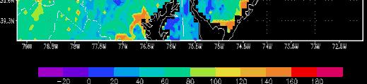
30 Daily Precipitation RPC Review (04/14/08) 30


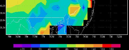
31 Differences in Daily Precipitation when compared to operational product RPC Review (04/14/08) 31
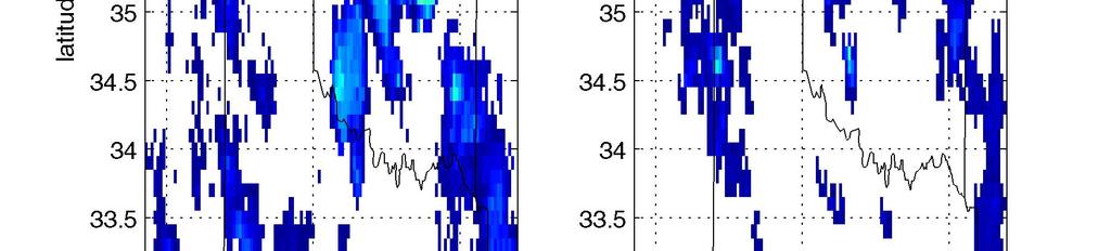
32 RPC Review (04/14/08) 32
33 Land Surface Model Configuration RPC Review (04/14/08) 33


34 Noah/LIS (v. 5.0) Land surface model set up 0.1x0.1 1 latitude-longitude longitude grid


35 Noah/LIS (v. 5.0) Land surface model set up 0.1x0.1 1 latitude-longitude longitude grid
 Baseline")
 of spin-up period.")

36 Atmospheric forcing fields to run Noah/LIS model North American Land data Assimilation System (NLDAS) Baseline (control) run with NLDAS precipitation Two complete years (2005 and 2006) of spin-up period. The years 2007 and 2008 are used for comparison with GPM synthetic precipitation products Comparison between NLDAS and CMORPH (GPM-Proxy) Forcings ( June 15, 2007, 06 UTC)


37


38


 model")


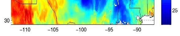
39 Examples of soil moisture simulated by Noah/LIS (control run) model June 15, 2007, 18 UTC (11-12 am of local time) GPM domain


40
41 Task ID Schedule Task Description Data collection and inventory 1.2 Full evaluation of precipitatation data 1.3 Error estimation 2.1 Regional validation 3.1 LIS Scontrol o simulations uato satco core estes sites 3.2 LIS simulations with different preciptation forcings 3.3 LIS validation against in-situ data 4.1 Document and report results RPC Review (04/14/08) 41
42 Contact Information Valentine Anantharaj edu> Tel: (662) RPC Review (04/14/08) 42
Optimization of GPM Precipitation Estimates for Land Data Assimilation Applications
 Optimization of GPM Precipitation Estimates for Land Data Assimilation Applications PI: Prof. Lori Bruce, Ph.D Mississippi State University GeoResources Institute GPM Optimization Team & MSU Team Lori
Estimation via Data Assimilation Using. Mississippi State University GeoResources Institute
 High Resolution Soil Moisture Estimation via Data Assimilation Using NASA Land Information System Mississippi State University GeoResources Institute LIS Evaluation Team & Collaborators RPC Team Valentine
2009 Progress Report To The National Aeronautics and Space Administration NASA Energy and Water Cycle Study (NEWS) Program
 Program") 2009 Progress Report To The National Aeronautics and Space Administration NASA Energy and Water Cycle Study (NEWS) Program Proposal Title: Grant Number: PI: The Challenges of Utilizing Satellite Precipitation
2009 Progress Report To The National Aeronautics and Space Administration NASA Energy and Water Cycle Study (NEWS) Program Proposal Title: Grant Number: PI: The Challenges of Utilizing Satellite Precipitation
EVALUATION OF GPM-ERA CONSTELLATION PRECIPITATION ESTIMATES FOR LAND SURFACE MODELING APPLICATIONS
 EVALUATION OF GPM-ERA CONSTELLATION PRECIPITATION ESTIMATES FOR LAND SURFACE MODELING APPLICATIONS F.Joseph Turk 1, G. Mostovoy 2, V. Anantharaj 2, P. Houser 3, QiQi Lu 4, Y. Ling 2 1 Naval Research Laboratory,
Passive and Active Microwave Sensors for Precipitation Research
 Passive and Active Microwave Sensors for Precipitation Research Joe Turk Jet Propulsion Laboratory California Institute of Technology Pasadena, CA jturk@jpl.nasa.gov Characteristics of Precipitation Wide
H-SAF future developments on Convective Precipitation Retrieval
 H-SAF future developments on Convective Precipitation Retrieval Francesco Zauli 1, Daniele Biron 1, Davide Melfi 1, Antonio Vocino 1, Massimiliano Sist 2, Michele De Rosa 2, Matteo Picchiani 2, De Leonibus
An Overview of Operations at the West Gulf River Forecast Center Gregory Waller Service Coordination Hydrologist NWS - West Gulf River Forecast Center
 National Weather Service West Gulf River Forecast Center An Overview of Operations at the West Gulf River Forecast Center Gregory Waller Service Coordination Hydrologist NWS - West Gulf River Forecast
Remote sensing of precipitation extremes
 The panel is about: Understanding and predicting weather and climate extreme Remote sensing of precipitation extremes Climate extreme : (JSC meeting, June 30 2014) IPCC SREX report (2012): Climate Ali
Land Data Assimilation at NCEP NLDAS Project Overview, ECMWF HEPEX 2004
 Dag.Lohmann@noaa.gov, Land Data Assimilation at NCEP NLDAS Project Overview, ECMWF HEPEX 2004 Land Data Assimilation at NCEP: Strategic Lessons Learned from the North American Land Data Assimilation System
The National Operational Hydrologic Remote Sensing Center Operational Snow Analysis
 The National Operational Hydrologic Remote Sensing Center Operational Snow Analysis World Meteorological Organization Global Cryosphere Watch Snow-Watch Workshop Session 3: Snow Analysis Products Andrew
Ensuring Water in a Changing World
 Ensuring Water in a Changing World Evaluation and application of satellite-based precipitation measurements for hydro-climate studies over mountainous regions: case studies from the Tibetan Plateau Soroosh
Global Precipitation Data Sets
 Global Precipitation Data Sets Rick Lawford (with thanks to Phil Arkin, Scott Curtis, Kit Szeto, Ron Stewart, etc) April 30, 2009 Toronto Roles of global precipitation products in drought studies: 1.Understanding
COMBINATION OF SATELLITE PRECIPITATION ESTIMATES AND RAIN GAUGE FOR HIGH SPATIAL AND TEMPORAL RESOLUTIONS INTRODUCTION
 COMBINATION OF SATELLITE PRECIPITATION ESTIMATES AND RAIN GAUGE FOR HIGH SPATIAL AND TEMPORAL RESOLUTIONS Ferreira, Rute Costa¹ ; Herdies, D. L.¹; Vila, D.A.¹; Beneti, C.A. A.² ¹ Center for Weather Forecasts
APPENDIX 2 OVERVIEW OF THE GLOBAL PRECIPITATION MEASUREMENT (GPM) AND THE TROPICAL RAINFALL MEASURING MISSION (TRMM) 2-1
 AND THE TROPICAL RAINFALL MEASURING MISSION (TRMM) 2-1") APPENDIX 2 OVERVIEW OF THE GLOBAL PRECIPITATION MEASUREMENT (GPM) AND THE TROPICAL RAINFALL MEASURING MISSION (TRMM) 2-1 1. Introduction Precipitation is one of most important environmental parameters.
APPENDIX 2 OVERVIEW OF THE GLOBAL PRECIPITATION MEASUREMENT (GPM) AND THE TROPICAL RAINFALL MEASURING MISSION (TRMM) 2-1 1. Introduction Precipitation is one of most important environmental parameters.
Evaluation of Satellite Precipitation Products over the Central of Vietnam
 Evaluation of Satellite Precipitation Products over the Central of Vietnam Long Trinh-Tuan (1), Jun Matsumoto (1,2), Thanh Ngo-Duc (3) (1) Department of Geography, Tokyo Metropolitan University, Japan.
The Hydrologic Cycle: How Do River Forecast Centers Measure the Parts?
 The Hydrologic Cycle: How Do River Forecast Centers Measure the Parts? Greg Story Meteorologist National Weather Service Fort Worth, TX Overview n Introduction What is the mission of an RFC? n The Hydrologic
Incorporation of SMOS Soil Moisture Data on Gridded Flash Flood Guidance for Arkansas Red River Basin
 Incorporation of SMOS Soil Moisture Data on Gridded Flash Flood Guidance for Arkansas Red River Basin Department of Civil and Environmental Engineering, The City College of New York, NOAA CREST Dugwon
The Global Precipitation Climatology Project (GPCP) CDR AT NOAA: Research to Real-time Climate Monitoring
 CDR AT NOAA: Research to Real-time Climate Monitoring") The Global Precipitation Climatology Project (GPCP) CDR AT NOAA: Research to Real-time Climate Monitoring Robert Adler, Matt Sapiano, Guojun Gu University of Maryland Pingping Xie (NCEP/CPC), George Huffman
The Global Precipitation Climatology Project (GPCP) CDR AT NOAA: Research to Real-time Climate Monitoring Robert Adler, Matt Sapiano, Guojun Gu University of Maryland Pingping Xie (NCEP/CPC), George Huffman
TRMM Multi-satellite Precipitation Analysis (TMPA)
") TRMM Multi-satellite Precipitation Analysis (TMPA) (sometimes known as 3B42/43, TRMM product numbers) R. Adler, G. Huffman, D. Bolvin, E. Nelkin, D. Wolff NASA/Goddard Laboratory for Atmospheres with key
TRMM Multi-satellite Precipitation Analysis (TMPA) (sometimes known as 3B42/43, TRMM product numbers) R. Adler, G. Huffman, D. Bolvin, E. Nelkin, D. Wolff NASA/Goddard Laboratory for Atmospheres with key
School on Modelling Tools and Capacity Building in Climate and Public Health April Remote Sensing
 2453-5 School on Modelling Tools and Capacity Building in Climate and Public Health 15-26 April 2013 Remote Sensing CECCATO Pietro International Research Institute for Climate and Society, IRI The Earth
Operational quantitative precipitation estimation using radar, gauge g and
 Operational quantitative precipitation estimation using radar, gauge g and satellite for hydrometeorological applications in Southern Brazil Leonardo Calvetti¹, Cesar Beneti¹, Diogo Stringari¹, i¹ Alex
A Prototype Precipitation Retrieval Algorithm Over Land for SSMIS and ATMS
 A Prototype Precipitation Retrieval Algorithm Over Land for SSMIS and ATMS Yalei You 1, Nai-Yu Wang 2, Ralph Ferraro 2 1 CICS-MD/ESSIC/UMD 2 STAR/NESDIS/NOAA Background Our group provided the level-2 rainfall
School on Modelling Tools and Capacity Building in Climate and Public Health April Rainfall Estimation
 2453-6 School on Modelling Tools and Capacity Building in Climate and Public Health 15-26 April 2013 Rainfall Estimation CECCATO Pietro International Research Institute for Climate and Society, IRI The
Remote Sensing Applications for Drought Monitoring
 Remote Sensing Applications for Drought Monitoring Amir AghaKouchak Center for Hydrometeorology and Remote Sensing Department of Civil and Environmental Engineering University of California, Irvine Outline
The Delaware Environmental Monitoring & Analysis Center
 The Delaware Environmental Monitoring & Analysis Center Tina Callahan Delaware Estuary Science & Environmental Summit 2013 January 27-30, 2013 What is DEMAC? Delaware Environmental Monitoring & Analysis
July 1987 December 2002
 16 October 2006 GLOBAL PRECIPITATION DATA SETS George J. Huffman 1 Table 1. Summary of publicly available, quasi-operational, quasi-global precipitation estimates from a single sensor type. Where appropriate,
An Ensemble Land Surface Modeling and Assimilation Testbed for HEPEX
 GSFC s Land Data Assimilation Systems: An Ensemble Land Surface Modeling and Assimilation Testbed for HEPEX Christa Peters-Lidard Lidard,, Paul Houser, Matthew Rodell, Brian Cosgrove NASA Goddard Space
Snowfall Detection and Rate Retrieval from ATMS
 Snowfall Detection and Rate Retrieval from ATMS Jun Dong 1, Huan Meng 2, Cezar Kongoli 1, Ralph Ferraro 2, Banghua Yan 2, Nai-Yu Wang 1, Bradley Zavodsky 3 1 University of Maryland/ESSIC/Cooperative Institute
Georgy V. Mostovoy*¹, Valentine Anantharaj¹, Paul R. Houser², and Christa D. Peters-Lidard³
 P2.3 USE OF SCAN OBSERVATIONS FOR VALIDATION OF SOIL MOISTURE SPATIAL DISTRIBUTION SIMULATED BY THE LAND-SURFACE MODEL OVER THE LOWER MISSISSIPPI DELTA REGION Georgy V. Mostovoy*¹, Valentine Anantharaj¹,
NASA Flood Monitoring and Mapping Tools
 National Aeronautics and Space Administration ARSET Applied Remote Sensing Training http://arset.gsfc.nasa.gov @NASAARSET NASA Flood Monitoring and Mapping Tools www.nasa.gov Outline Overview of Flood
CGMS Baseline. Sustained contributions to the Global Observing System. Endorsed by CGMS-46 in Bengaluru, June 2018
 CGMS Baseline Sustained contributions to the Global Observing System Best Practices for Achieving User Readiness for New Meteorological Satellites Endorsed by CGMS-46 in Bengaluru, June 2018 CGMS/DOC/18/1028862,
CGMS Baseline In response to CGMS action/recommendation A45.01 HLPP reference: 1.1.8
 Prepared by WGIII Agenda Item: 7.1 Discussed in WGIII CGMS Baseline In response to CGMS action/recommendation A45.01 HLPP reference: 1.1.8 In CGMS-45, Working Group III agreed to hold a review of the CGMS
Haiti and Dominican Republic Flash Flood Initial Planning Meeting
 Dr Rochelle Graham Climate Scientist Haiti and Dominican Republic Flash Flood Initial Planning Meeting September 7 th to 9 th, 2016 Hydrologic Research Center http://www.hrcwater.org Haiti and Dominican
A statistical approach for rainfall confidence estimation using MSG-SEVIRI observations
 A statistical approach for rainfall confidence estimation using MSG-SEVIRI observations Elisabetta Ricciardelli*, Filomena Romano*, Nico Cimini*, Frank Silvio Marzano, Vincenzo Cuomo* *Institute of Methodologies
Quantitative Precipitation Estimation using Satellite and Ground Measurements
 Quantitative Precipitation Estimation using Satellite and Ground Measurements Kuolin Hsu Center for Hydrometeorology and Remote Sensing University of California Irvine XVII Congress of the Spanish Association
P4.4 THE COMBINATION OF A PASSIVE MICROWAVE BASED SATELLITE RAINFALL ESTIMATION ALGORITHM WITH AN IR BASED ALGORITHM
 P4.4 THE COMBINATION OF A PASSIVE MICROWAVE BASED SATELLITE RAINFALL ESTIMATION ALGORITHM WITH AN IR BASED ALGORITHM Robert Joyce 1), John E. Janowiak 2), and Phillip A. Arkin 3, Pingping Xie 2) 1) RS
REVISION OF THE STATEMENT OF GUIDANCE FOR GLOBAL NUMERICAL WEATHER PREDICTION. (Submitted by Dr. J. Eyre)
") WORLD METEOROLOGICAL ORGANIZATION Distr.: RESTRICTED CBS/OPAG-IOS (ODRRGOS-5)/Doc.5, Add.5 (11.VI.2002) COMMISSION FOR BASIC SYSTEMS OPEN PROGRAMME AREA GROUP ON INTEGRATED OBSERVING SYSTEMS ITEM: 4 EXPERT
WORLD METEOROLOGICAL ORGANIZATION Distr.: RESTRICTED CBS/OPAG-IOS (ODRRGOS-5)/Doc.5, Add.5 (11.VI.2002) COMMISSION FOR BASIC SYSTEMS OPEN PROGRAMME AREA GROUP ON INTEGRATED OBSERVING SYSTEMS ITEM: 4 EXPERT
Judit Kerényi. OMSZ - Hungarian Meteorological Service, Budapest, Hungary. H-1525 Budapest, P.O.Box 38, Hungary.
 SATELLITE-DERIVED PRECIPITATION ESTIMATIONS DEVELOPED BY THE HYDROLOGY SAF PROJECT CASE STUDIES FOR THE INVESTIGATION OF THEIR ACCURACY AND FEATURES IN HUNGARY Judit Kerényi OMSZ - Hungarian Meteorological
Arkansas-Red Basin River Forecast Center Operations. RRVA Conference Durant, OK 8/22/2013 Jeff McMurphy Sr. Hydrologist - ABRFC
 Arkansas-Red Basin River Forecast Center Operations RRVA Conference Durant, OK 8/22/2013 Jeff McMurphy Sr. Hydrologist - ABRFC NWS River Forecast Centers NWS Weather Forecast Offices Operations Staffing
Current and Upcoming NASA Hurricane Measurement Missions National Hurricane Conference
 NASA Science Mission Directorate Earth Science Division Applied Sciences Program Current and Upcoming NASA Hurricane Measurement Missions National Hurricane Conference April 18, 2017 Formulation Implementation
P r o c e. d i n g s. 1st Workshop. Madrid, Spain September 2002
 P r o c e e d i n g s 1st Workshop Madrid, Spain 23-27 September 2002 VALIDATION OF AN OPERATIONAL GLOBAL PRECIPITATION ANALYSIS AT SHORT TIME SCALES F. Joseph Turk 1, Elizabeth E. Ebert 2, Hyun-Jong Oh
Japanese Programs on Space and Water Applications
 Japanese Programs on Space and Water Applications Tamotsu IGARASHI Remote Sensing Technology Center of Japan June 2006 COPUOS 2006 Vienna International Centre Water-related hazards/disasters may occur
NEW SCHEME TO IMPROVE THE DETECTION OF RAINY CLOUDS IN PUERTO RICO
 NEW SCHEME TO IMPROVE THE DETECTION OF RAINY CLOUDS IN PUERTO RICO Joan Manuel Castro Sánchez Advisor Dr. Nazario Ramirez UPRM NOAA CREST PRYSIG 2016 October 7, 2016 Introduction A cloud rainfall event
Abebe Sine Gebregiorgis, PhD Postdoc researcher. University of Oklahoma School of Civil Engineering and Environmental Science
 Abebe Sine Gebregiorgis, PhD Postdoc researcher University of Oklahoma School of Civil Engineering and Environmental Science November, 2014 MAKING SATELLITE PRECIPITATION PRODUCTS WORK FOR HYDROLOGIC APPLICATION
Canadian Prairie Snow Cover Variability
 Canadian Prairie Snow Cover Variability Chris Derksen, Ross Brown, Murray MacKay, Anne Walker Climate Research Division Environment Canada Ongoing Activities: Snow Cover Variability and Links to Atmospheric
REQUIREMENTS FOR WEATHER RADAR DATA. Review of the current and likely future hydrological requirements for Weather Radar data
 WORLD METEOROLOGICAL ORGANIZATION COMMISSION FOR BASIC SYSTEMS OPEN PROGRAMME AREA GROUP ON INTEGRATED OBSERVING SYSTEMS WORKSHOP ON RADAR DATA EXCHANGE EXETER, UK, 24-26 APRIL 2013 CBS/OPAG-IOS/WxR_EXCHANGE/2.3
Director: Soroosh Sorooshian
 Director: Soroosh Sorooshian X. Gao B. Imam K. Hsu S. O Rourke D. Hohnbaum J. Li G.H. Park D. Braithwaite E. Pritchard B. Khakbaz W. Chu A. Behrangi Alex R. Sutlana Joey A. Zahraei Developing state-of-the-art
Overview of Data for CREST Model
 Overview of Data for CREST Model Xianwu Xue April 2 nd 2012 CREST V2.0 CREST V2.0 Real-Time Mode Forcasting Mode Data Assimilation Precipitation PET DEM, FDR, FAC, Slope Observed Discharge a-priori parameter
Global Flood Alert System based on satellite derived rainfall data -Targeting the era of Global Precipitation Measurement (GPM)-
-") Global Flood Alert System based on satellite derived rainfall data -Targeting the era of Global Precipitation Measurement (GPM)- Riko Oki, Misako Kachi (JAXA/EORC) Kazuhiko Fukami (PWRI) and Kazuo Umeda
Global Flood Alert System based on satellite derived rainfall data -Targeting the era of Global Precipitation Measurement (GPM)- Riko Oki, Misako Kachi (JAXA/EORC) Kazuhiko Fukami (PWRI) and Kazuo Umeda
The Australian Operational Daily Rain Gauge Analysis
 The Australian Operational Daily Rain Gauge Analysis Beth Ebert and Gary Weymouth Bureau of Meteorology Research Centre, Melbourne, Australia e.ebert@bom.gov.au Daily rainfall data and analysis procedure
Regional Flash Flood Guidance and Early Warning System
 WMO Training for Trainers Workshop on Integrated approach to flash flood and flood risk management 24-28 October 2010 Kathmandu, Nepal Regional Flash Flood Guidance and Early Warning System Dr. W. E. Grabs
The Global Precipitation Measurement (GPM) Mission: Arthur Hou. NASA Goddard Space Flight Center
 Mission: Arthur Hou. NASA Goddard Space Flight Center") The Global Precipitation Measurement (GPM) Mission: Overview and U.S. Status Arthur Hou NASA Goddard Space Flight Center 5 th IPWG Workshop 11-15 October 2010 GPM Mission Concept An international ti satellite
The Global Precipitation Measurement (GPM) Mission: Overview and U.S. Status Arthur Hou NASA Goddard Space Flight Center 5 th IPWG Workshop 11-15 October 2010 GPM Mission Concept An international ti satellite
Evapotranspiration monitoring with Meteosat Second Generation satellites: method, products and utility in drought detection.
 Evapotranspiration monitoring with Meteosat Second Generation satellites: method, products and utility in drought detection. Nicolas Ghilain Royal Meteorological Institute Belgium EUMeTrain Event week
Amita Mehta and Ana Prados
 Building Capacity in Utilizing NASA Remote Sensing Observations in SWAT for Water Resources and Agricultural Management Applications Amita Mehta and Ana Prados NASA - University of Maryland Baltimore County
Recent Data Assimilation Activities at Environment Canada
 Recent Data Assimilation Activities at Environment Canada Major upgrade to global and regional deterministic prediction systems (now in parallel run) Sea ice data assimilation Mark Buehner Data Assimilation
Land data assimilation in the NASA GEOS-5 system: Status and challenges
 Blueprints for Next-Generation Data Assimilation Systems Boulder, CO, USA 8-10 March 2016 Land data assimilation in the NASA GEOS-5 system: Status and challenges Rolf Reichle Clara Draper, Ricardo Todling,
Surface Hydrology Research Group Università degli Studi di Cagliari
 Surface Hydrology Research Group Università degli Studi di Cagliari Evaluation of Input Uncertainty in Nested Flood Forecasts: Coupling a Multifractal Precipitation Downscaling Model and a Fully-Distributed
Application of Radar QPE. Jack McKee December 3, 2014
 Application of Radar QPE Jack McKee December 3, 2014 Topics Context Precipitation Estimation Techniques Study Methodology Preliminary Results Future Work Questions Introduction Accurate precipitation data
P r o c e. d i n g s. 1st Workshop. Madrid, Spain September 2002
 P r o c e e d i n g s 1st Workshop Madrid, Spain 23-27 September 2002 IMPACTS OF IMPROVED ERROR ANALYSIS ON THE ASSIMILATION OF POLAR SATELLITE PASSIVE MICROWAVE PRECIPITATION ESTIMATES INTO THE NCEP GLOBAL
Earth Science Flight Mission Overview
 Earth Science Flight Mission Overview Nand Topiwala Science Mission Directorate NASA Headquarters April 25, 2007 Earth Science Missions Afternoon Constellation, or A-Train, Multi-Satellite Observatory
NIDIS Intermountain West Drought Early Warning System January 15, 2019
 NIDIS Drought and Water Assessment NIDIS Intermountain West Drought Early Warning System January 15, 2019 Precipitation The images above use daily precipitation statistics from NWS COOP, CoCoRaHS, and
The National Weather Service of the Future: Building a Weather-Ready Nation
 The of the Future: Building a Weather-Ready Nation Dr. Louis W. Uccellini Director, NOAA Assistant Administrator for Weather Services NCEP Production Suite Review December 2, 2014 Outline Building a Weather-Ready
Application of Pattern Recognition and Adaptive DSP Methods for Spatio-temporal Analysis of Satellite Based Hydrological Datasets
 Application of Pattern Recognition and Adaptive DSP Methods for Spatio-temporal Analysis of Satellite Based Hydrological Datasets Anish Chand Turlapaty DISSERTATION.COM Boca Raton Application of Pattern
EVALUATION OF SATELLITE-DERIVED HIGH RESOLUTION RAINFALL ESTIMATES OVER EASTERN SÃO PAULO AND PARANÁ,, BRAZIL
 EVALUATION OF SATELLITE-DERIVED HIGH RESOLUTION RAINFALL ESTIMATES OVER EASTERN SÃO PAULO AND PARANÁ,, BRAZIL Augusto J. Pereira Filho 1 Phillip Arkin 2 Joe Turk 3 John E. Janowiak 4 Cesar Beneti 5 Leonardo
The Properties of Convective Clouds Over the Western Pacific and Their Relationship to the Environment of Tropical Cyclones
 The Properties of Convective Clouds Over the Western Pacific and Their Relationship to the Environment of Tropical Cyclones Principal Investigator: Dr. Zhaoxia Pu Department of Meteorology, University
The Status of NOAA/NESDIS Precipitation Algorithms and Products
 The Status of NOAA/NESDIS Precipitation Algorithms and Products Ralph Ferraro NOAA/NESDIS College Park, MD USA S. Boukabara, E. Ebert, K. Gopalan, J. Janowiak, S. Kidder, R. Kuligowski, H. Meng, M. Sapiano,
SMAP and SMOS Integrated Soil Moisture Validation. T. J. Jackson USDA ARS
 SMAP and SMOS Integrated Soil Moisture Validation T. J. Jackson USDA ARS Perspective Linkage of SMOS and SMAP soil moisture calibration and validation will have short and long term benefits for both missions.
Seasonal Hydrological Forecasting in the Berg Water Management Area of South Africa
 Seasonal Hydrological Forecasting in the Berg Water Management Area of South Africa Trevor LUMSDEN and Roland SCHULZE University of KwaZulu-Natal, South Africa OUTLINE Introduction Objectives Study Area
United States Multi-Hazard Early Warning System
 United States Multi-Hazard Early Warning System Saving Lives Through Partnership Lynn Maximuk National Weather Service Director, Central Region Kansas City, Missouri America s s Weather Enterprise: Protecting
The assimilation of AMSU and SSM/I brightness temperatures in clear skies at the Meteorological Service of Canada
 The assimilation of AMSU and SSM/I brightness temperatures in clear skies at the Meteorological Service of Canada Abstract David Anselmo and Godelieve Deblonde Meteorological Service of Canada, Dorval,
Satellite Soil Moisture in Research Applications
 Satellite Soil Moisture in Research Applications Richard de Jeu richard.de.jeu@falw.vu.nl Thomas Holmes, Hylke Beck, Guojie Wang, Han Dolman (VUA) Manfred Owe (NASA-GSFC) Albert Van Dijk, Yi Liu (CSIRO)
GENERAL DESCRIPTION OF THE WEATHER FORECAST PROCESS WITH EMPHASIS ON FORECAST UNCERTAINTY. Zoltan Toth
 GENERAL DESCRIPTION OF THE WEATHER FORECAST PROCESS WITH EMPHASIS ON FORECAST UNCERTAINTY Zoltan Toth Environmental Modeling Center NOAA/NWS/NCEP USA Acknowledgements: Steve Lord, David Helms, Geoff DiMego,
Real case simulations using spectral bin cloud microphysics: Remarks on precedence research and future activity
 Real case simulations using spectral bin cloud microphysics: Remarks on precedence research and future activity Takamichi Iguchi 1,2 (takamichi.iguchi@nasa.gov) 1 Earth System Science Interdisciplinary
Advances in weather modelling
 Advances in weather modelling www.cawcr.gov.au Robert Fawcett - speaking on behalf of CAWCR Earth-System Modelling and CAWCR Weather and Environmental Prediction May 2013 The Centre for Australian Weather
Spaceborne and Ground-based Global and Regional Precipitation Estimation: Multi-Sensor Synergy
 Hydrometeorology and Remote Sensing Lab (hydro.ou.edu) at The University of Oklahoma Spaceborne and Ground-based Global and Regional Precipitation Estimation: Multi-Sensor Synergy Presented by: 温逸馨 (Berry)
MAIN ATTRIBUTES OF THE PRECIPITATION PRODUCTS DEVELOPED BY THE HYDROLOGY SAF PROJECT RESULTS OF THE VALIDATION IN HUNGARY
 MAIN ATTRIBUTES OF THE PRECIPITATION PRODUCTS DEVELOPED BY THE HYDROLOGY SAF PROJECT RESULTS OF THE VALIDATION IN HUNGARY Eszter Lábó OMSZ-Hungarian Meteorological Service, Budapest, Hungary labo.e@met.hu
Satellite data for hydrological forecasting
 Satellite data for hydrological forecasting Current use at ECMWF and perspective Shopping list! Our current tools does not allow direct use, but could be modified Christel Prudhomme Christel.prudhomme@ecmwf.int
An Overview of Atmospheric Analyses and Reanalyses for Climate
 An Overview of Atmospheric Analyses and Reanalyses for Climate Kevin E. Trenberth NCAR Boulder CO Analysis Data Assimilation merges observations & model predictions to provide a superior state estimate.
Interpretation of Polar-orbiting Satellite Observations. Atmospheric Instrumentation
 Interpretation of Polar-orbiting Satellite Observations Outline Polar-Orbiting Observations: Review of Polar-Orbiting Satellite Systems Overview of Currently Active Satellites / Sensors Overview of Sensor
Precipitation. Standardized Precipitation Index. NIDIS Intermountain West Regional Drought Early Warning System January 3, 2017
 1/3/2017 NIDIS Drought and Water Assessment NIDIS Intermountain West Regional Drought Early Warning System January 3, 2017 Precipitation The images above use daily precipitation statistics from NWS COOP,
H SAF SATELLITE APPLICATION FACILITY ON SUPPORT TO OPERATIONAL HYDROLOGY AND WATER MANAGEMENT EUMETSAT NETWORK OF SATELLITE APPLICATION FACILITIES
 H SAF SATELLITE APPLICATION FACILITY ON SUPPORT TO OPERATIONAL HYDROLOGY AND WATER MANAGEMENT EUMETSAT NETWORK OF SATELLITE APPLICATION FACILITIES H-SAF: SATELLITE PRODUCTS FOR OPERATIONAL HYDROLOGY H-SAF
Water information system advances American River basin. Roger Bales, Martha Conklin, Steve Glaser, Bob Rice & collaborators UC: SNRI & CITRIS
 Water information system advances American River basin Roger Bales, Martha Conklin, Steve Glaser, Bob Rice & collaborators UC: SNRI & CITRIS Opportunities Unprecedented level of information from low-cost
Land surface precipitation and hydrology in MERRA-2
 Land surface precipitation and hydrology in MERRA-2 R. Reichle, R. Koster, C. Draper, Q. Liu, M. Girotto, S. Mahanama, G. De Lannoy, G. Partyka, and many others 5th International Conference on Reanalysis
Analyzing and Visualizing Precipitation and Soil Moisture in ArcGIS
 Analyzing and Visualizing Precipitation and Soil Moisture in ArcGIS Wenli Yang, Pham Long, Peisheng Zhao, Steve Kempler, and Jennifer Wei * NASA Goddard Earth Science Data and Information Services Center
Some NOAA Products that Address PSTG Satellite Observing Requirements. Jeff Key NOAA/NESDIS Madison, Wisconsin USA
 Some NOAA Products that Address PSTG Satellite Observing Requirements Jeff Key NOAA/NESDIS Madison, Wisconsin USA WMO Polar Space Task Group, 4 th meeting, Greenbelt, 30 September 2014 Relevant Missions
Multi-Sensor Precipitation Reanalysis
 Multi-Sensor Precipitation Reanalysis Brian R. Nelson, Dongsoo Kim, and John J. Bates NOAA National Climatic Data Center, Asheville, North Carolina D.J. Seo NOAA NWS Office of Hydrologic Development, Silver
Operational Perspectives on Hydrologic Model Data Assimilation
 Operational Perspectives on Hydrologic Model Data Assimilation Rob Hartman Hydrologist in Charge NOAA / National Weather Service California-Nevada River Forecast Center Sacramento, CA USA Outline Operational
AMS copyrighted work
 AMS copyrighted work Copyright 2014 American Meteorological Society (AMS). Permission to use figures, tables, and brief excerpts from this work in scientific and educational works is hereby granted provided
How does NASA study hurricanes? 17 August 2015, by Max Gleber
 How does NASA study hurricanes? 17 August 2015, by Max Gleber Hurricanes are the most powerful weather event on Earth. NASA's expertise in space and scientific exploration contributes to essential services
Pre-Operational Assimilation Testing of the Defense Meteorological Satellite Program (DMSP) Special Sensor Microwave Imager/Sounder (SSMI/S)
 Special Sensor Microwave Imager/Sounder (SSMI/S)") Pre-Operational Assimilation Testing of the Defense Meteorological Satellite Program (DMSP) Special Sensor Microwave Imager/Sounder (SSMI/S) William Campbell 1, Steve Swadley 2, William Bell 3, Clay Blankenship
Pre-Operational Assimilation Testing of the Defense Meteorological Satellite Program (DMSP) Special Sensor Microwave Imager/Sounder (SSMI/S) William Campbell 1, Steve Swadley 2, William Bell 3, Clay Blankenship
Assimilation of precipitation-related observations into global NWP models
 Assimilation of precipitation-related observations into global NWP models Alan Geer, Katrin Lonitz, Philippe Lopez, Fabrizio Baordo, Niels Bormann, Peter Lean, Stephen English Slide 1 H-SAF workshop 4
EUMETSAT Hydrological SAF H05 product development at CNMCA
 EUMETSAT Hydrological SAF H05 product development at CNMCA Luigi De Leonibus, Francesco Zauli, Antonio Vocino, Daniele Biron, Davide Melfi, Marco Petracca Centro Nazionale di Meteorologia e Climatologia
across track scanning microwave radiometer CIS CrIS Fourier transform spectrometer cross-track resolution: 14.0 km vertical resolution: ~ 3.
 A Rapid Prototyping Capability Experiment to Evaluate CrIS / ATMS Observations for Urban Modeling Applications (PI: Prof. Lori Bruce, Ph.D) Christopher M. Hill Patrick J. Fitzpatrick Valentine ae e G.
1.11 CROSS-VALIDATION OF SOIL MOISTURE DATA FROM AMSR-E USING FIELD OBSERVATIONS AND NASA S LAND DATA ASSIMILATION SYSTEM SIMULATIONS
 1.11 CROSS-VALIDATION OF SOIL MOISTURE DATA FROM AMSR-E USING FIELD OBSERVATIONS AND NASA S LAND DATA ASSIMILATION SYSTEM SIMULATIONS Alok K. Sahoo *, Xiwu Zhan** +, Kristi Arsenault** and Menas Kafatos
Dual-Frequency Ku- Band Radar Mission Concept for Snow Mass
 Dual-Frequency Ku- Band Radar Mission Concept for Snow Mass Chris Derksen Environment and Climate Change Canada Study Team: Climate Research Division/Meteorological Research Division, ECCC Canadian Space
Real-Time Meteorological Gridded Data: What s New With HEC-RAS
 Real-Time Meteorological Gridded Data: What s New With HEC-RAS Acquisition and Application of Gridded Meteorological Data in Support of the USACE s Real-Time Water Management Mission Fauwaz Hanbali, Tom
Assimilation of Satellite Cloud and Precipitation Observations in NWP Models: Report of a Workshop
 Assimilation of Satellite Cloud and Precipitation Observations in NWP Models: Report of a Workshop George Ohring and Fuzhong Weng Joint Center for Satellite Data Assimilation Ron Errico NASA/GSFC Global
Rainfall-River Forecasting: Overview of NOAA s Role, Responsibilities, and Services
 Dr. Thomas Graziano Chief Hydrologic Services Division NWS Headquarters Steve Buan Service Coordination Hydrologist NWS North Central River Forecast Center Rainfall-River Forecasting: Overview of NOAA
Regional climate modelling in the future. Ralf Döscher, SMHI, Sweden
 Regional climate modelling in the future Ralf Döscher, SMHI, Sweden The chain Global H E H E C ( m 3/s ) Regional downscaling 120 adam 3 C HAM 4 adam 3 C HAM 4 trl A2 A2 B2 B2 80 40 0 J F M A M J J A S
"Cloud and Rainfall Observations using Microwave Radiometer Data and A-priori Constraints" Christian Kummerow and Fang Wang Colorado State University
 "Cloud and Rainfall Observations using Microwave Radiometer Data and A-priori Constraints" Christian Kummerow and Fang Wang Colorado State University ECMWF-JCSDA Workshop Reading, England June 16-18, 2010