Remote Sensing Applications for Drought Monitoring
|
|
|
- Marianna Holland
- 5 years ago
- Views:
Transcription


1 Remote Sensing Applications for Drought Monitoring Amir AghaKouchak Center for Hydrometeorology and Remote Sensing Department of Civil and Environmental Engineering University of California, Irvine

2 Outline


3 Space-Based Observations Satellite Observations: Rainfall Estimation Center for Hydrometeorology and Remote Sensing, University of
4 Precipitation Estimation from Remotely Sensed Information using Artificial Neural Networks (PERSIANN) PERSIANN System Precipitation Estimation from Remotely Sensed Information using Artificial Neural Networks Center for Hydrometeorology and Remote Sensing, University of


 Feedback PERSIANN")

 High Temporal-Spatial")


5 Satellite Data Ground Observations Precipitation Estimation from Remotely Sensed Information using Artificial Neural Networks (PERSIANN) Feedback PERSIANN System Estimation Global IR ANN Products Hourly Global Precipitation Estimates (CPC, NOAA) High Temporal-Spatial Res. Cloud Infrared Images MW-RR (TRMM, NOAA, DMSP Satellites) MW-PR Hourly Rain Rates (GSFC, NASA; NESDIS, NOAA) Sampling Error Detection Hourly Rain Estimate Quality Control GPCC & CPC Gauge Analysis Merged Products - Hourly rainfall - 6 hourly rainfall - Daily rainfall - Monthly rainfall Merging Gauges Coverage Center for Hydrometeorology Center for Hydrometeorology and Remote Sensing, and Remote University Sensing, of California, University of

6 Real Time Global Data: Cooperation With UNESCO Center for Hydrometeorology and Remote Sensing, University of

7 PERSIANN Satellite Product On Google Earth & App App: RainMapper Center for Hydrometeorology and Remote Sensing, University of


8 PERSIANN Extensions: Climate-Related PERSIANN-CDR Center for Hydrometeorology and Remote Sensing, University of


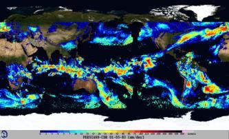
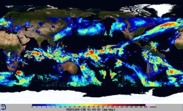
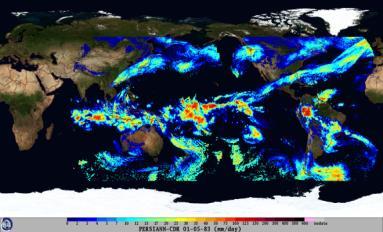
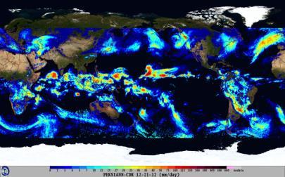
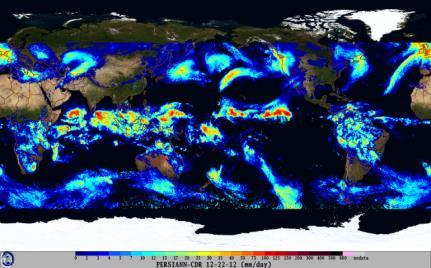
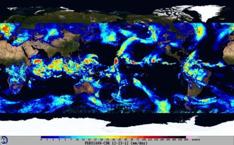
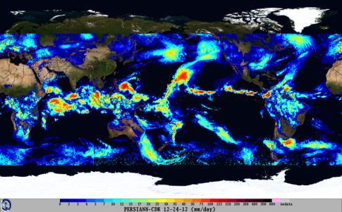
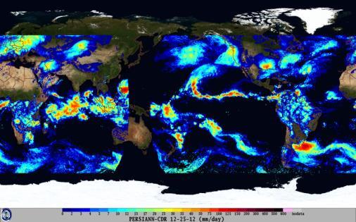
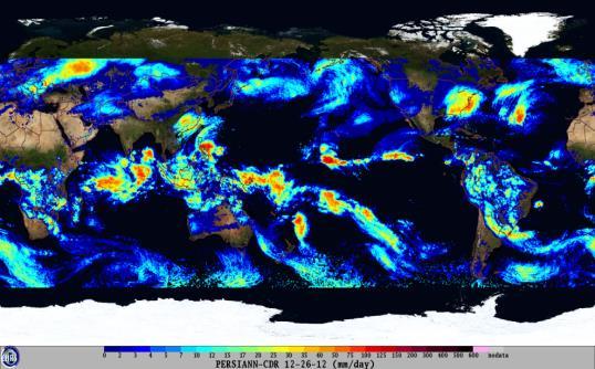
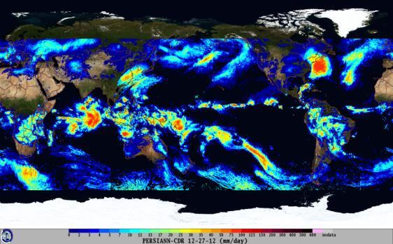
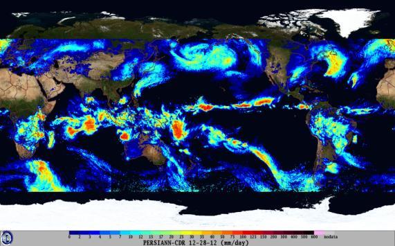
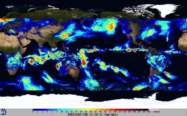
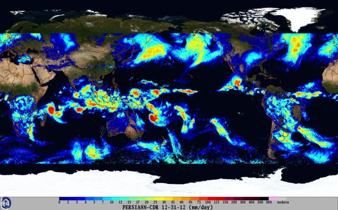
9 01/01/ /02/ /03/ /04/ /05/1983../../.../../.../../. 12/24/ /25/ /26/ /27/ /28/ /29/ /30/ /31/2012 PERSIANN-CDR A 30-Year, Daily, 0.25o, Global Center for Hydrometeorology and Remote Sensing, University of Precipitation Climate Data Record
 Search For All Storms During 2001: 106")

10 PERSIANN-CONNECT Exploratory Analysis b) Search For A Single Storm c) Search For All Storms During 2001: 106 Events :00: :00:00 Center for Hydrometeorology and Remote Sensing, University of

11 Global Integrated Drought Monitoring and Prediction System (GIDMaPS)
12 GIDMaPS: Global Integrated Drought Monitoring and Prediction System Meteorological Drought Agricultural Drought

13 GIDMaPS: Global Integrated Drought Monitoring and Prediction System Meteorological Drought Agricultural Drought Meteo-Agricul. Drought

14 GIDMaPS: Global Integrated Drought Monitoring and Prediction System

 Standardized runoff Index (SRI) Palmer Drought Severity")
15 Drought Definition and Indicators Different drought indices based on different climate variables (e.g., Precipitation, soil moisture): Standardized Precipitation Index (SPI) Standardized Soil Moisture Index (SSI) Standardized runoff Index (SRI) Palmer Drought Severity Index (PDSI) Precipitation (D-Scale) Jan 2012 Soil Moisture (D-Scale) Jan 2012
16 Multi-Index Drought Monitoring Standardized Precipitation Index (SPI) pspi P( X x) SPI 1 pspi Standardized Soil moisture Index (SSI) pssi 1 P( Y y) SSI pssi Multivariate Standardized Drought Index (MSDI) pmsdi P( X x, Y y) MSDI (Hao and AghaKouchak, 2013): Standardized index similar to SPI Improves drought onset detection A multi-index for composite meteorological -agricultural drought monitoring MSDI 1 pmsdi Where: X: accumulated precipitation; Y: accumulated soil moisture; φ: standard normal distribution

17 Multi-Index Drought Monitoring Sample time series of the 6-month SPI, SSI and MSDI for a grid cell in Texas (Location: longitude 100 W and latitude 30 N).

18 1-Month SPI and SSI Derived Using NASA MERRA-LAND Precipitation and soil moisture Data. Multi-Index Drought Monitoring

19 Multi-Index Drought Monitoring
, D1 (moderate), D2 (severe), D3 (extreme), and D4 (exceptional) drought condition (Data:")
20 GIDMaPS: Global Integrated Drought Monitoring and Prediction System Fraction of the global land in D0 (abnormally dry), D1 (moderate), D2 (severe), D3 (extreme), and D4 (exceptional) drought condition (Data: Standardized Precipitation Index data derived from MERRA-Land).

")
21 GIDMaPS: Global Integrated Drought Monitoring and Prediction System a) Area under moderate drought
22 GIDMaPS: Global Integrated Drought Monitoring and Prediction System Empirical PDF Matching Mean-Fields Bias Removal Bayesian-Based Correction Algorithm Parametric Fitting Correction Real-Time Data Global Precipitation Climatology Project + ~18 Months Real-Time Data ~ 32 Years Satellite-Based Rainfall Data where G and S denote GPCP and real-time satellite data (here, PERSIANN and TRMM- RT). The conditional probability P(G S) indicates the likelihood of the measurement G given the satellite observation S Present AghaKouchak A., and Nakhjiri N., 2012, A Near Real-Time Satellite-Based Global Drought Climate Data Record, Environmental Research Letters, 7(4), , doi: / /7/4/

.")
 May June (1-month lead) 45 45 45 40 40 40 35 35 35 30 30 30-120 -100-80 -120-100 -80")

23 9-18 Months Real-Time 1-, 6-Month Forecast GIDMaPS: Global Integrated Drought Monitoring and Prediction System Prediction component is based on a drought persistence model which requires historical observations. The seasonal drought prediction component is based on two input data sets (MERRA and NLDAS) and three drought indicators (SPI, SSI and MSDI). Ai+1(1)= Si-4+ Si-3+ Si-2 +Si-1+ Si +S(1)i+1 Ai+1(2)= Si-4+ Si-3+ Si-2 +Si-1+ Si +S(2)i+1... May (1-month lead) May June (1-month lead) July (1-month lead) July (1-month lead) ~ 30 Years Satellite-Based Rainfall Data August (1-month lead) June (1-month August (1-mont Ai+1(m)= Si-4+ Si-3+ Si-2 +Si-1+ Si +S(m)i NOW
24 Improving Early Drought Detection Using Satellite Observations
25 Integration of AIRS Data into GIDMaPS Precipitation (MERRA) Soil Moisture (MERRA) Relative Humidity (AIRS Data)
26 Integration of AIRS Data into GIDMaPS Precipitation (MERRA) Soil Moisture (MERRA) Relative Humidity (AIRS Data)
27 Integration of AIRS Data into GIDMaPS Precipitation (MERRA) Soil Moisture (MERRA) Relative Humidity (AIRS Data)
 Soil Moisture (MERRA) Relative Humidity (AIRS")
28 Integration of AIRS Data into GIDMaPS Precipitation (MERRA) Soil Moisture (MERRA) Relative Humidity (AIRS Data)
29 Integration of AIRS Data into GIDMaPS
30 Integration of AIRS Data into GIDMaPS

 based on SRHI is less or equal to that of SPI")
31 Integration of AIRS Data into GIDMaPS Probability of drought detection (i.e., fraction of detected drought) when Drought Onset (DO) based on SRHI is less or equal to that of SPI (a), mean lead time based on SRHI relative to SPI (months)(b).
32 Summary GIDMaPS provides both monitoring and prediction capabilities based on multiple data sets and drought indicators. MSDI leads to a composite product based on the joint distribution of precipitation and soil moisture. It can be used for multi-index drought assessment. Real-time PERSIANN Precipitation data sets can be used for near real-time drought monitoring and improving initial conditions for drought prediction. PERSIANN-CDR data offers daily long-term data sets that can be used for drought monitoring and assessment. There are opportunities to integrate the Atmospheric Infrared Sounder (AIRS) relative humidity data into GIDMaPS to improve drought early detection.


33 Research Team: Present and Recent Past S. Sellars Center for Hydrometeorology and Remote Sensing, University of and many more
34 References AghaKouchak A., and Nakhjiri N., 2012, A Near Real-Time Satellite-Based Global Drought Climate Data Record, Environmental Research Letters, 7(4), , doi: / /7/4/ Damberg L., AghaKouchak A., 2014, Global Trends and Patterns of Droughts from Space, Theoretical and Applied Climatology, 117(3), , doi: /s Golian S., Mazdiyasni O., AghaKouchak A., 2014, Trends in Meteorological and Agricultural Droughts in Iran, Theoretical and Applied Climatology, doi: /s Hao Z., AghaKouchak A., Nakhjiri N., Farahmand A., 2014, Global Integrated Drought Monitoring and Prediction System,Scientific Data, 1:140001, 1-10, doi: /sdata Tabari H., AghaKouchak A., Willems P., 2014, A perturbation approach for assessing trends in precipitation extremes, Journal of Hydrology, 519, , doi: /j.jhydrol
Global Integrated Drought Monitoring and Prediction System. GIDMaPS
 Global Integrated Drought Monitoring and Prediction System GIDMaPS Global Integrated Drought Monitoring and Prediction System GIDMaPS and Center for Hydrology & Remote Sensing Authors: Amir AghaKouchak
Ensuring Water in a Changing World
 Ensuring Water in a Changing World Evaluation and application of satellite-based precipitation measurements for hydro-climate studies over mountainous regions: case studies from the Tibetan Plateau Soroosh
2009 Progress Report To The National Aeronautics and Space Administration NASA Energy and Water Cycle Study (NEWS) Program
 Program") 2009 Progress Report To The National Aeronautics and Space Administration NASA Energy and Water Cycle Study (NEWS) Program Proposal Title: Grant Number: PI: The Challenges of Utilizing Satellite Precipitation
2009 Progress Report To The National Aeronautics and Space Administration NASA Energy and Water Cycle Study (NEWS) Program Proposal Title: Grant Number: PI: The Challenges of Utilizing Satellite Precipitation
Analyzing and Visualizing Precipitation and Soil Moisture in ArcGIS
 Analyzing and Visualizing Precipitation and Soil Moisture in ArcGIS Wenli Yang, Pham Long, Peisheng Zhao, Steve Kempler, and Jennifer Wei * NASA Goddard Earth Science Data and Information Services Center
Quantitative Precipitation Estimation using Satellite and Ground Measurements
 Quantitative Precipitation Estimation using Satellite and Ground Measurements Kuolin Hsu Center for Hydrometeorology and Remote Sensing University of California Irvine XVII Congress of the Spanish Association
Evaluation of Satellite Precipitation Products over the Central of Vietnam
 Evaluation of Satellite Precipitation Products over the Central of Vietnam Long Trinh-Tuan (1), Jun Matsumoto (1,2), Thanh Ngo-Duc (3) (1) Department of Geography, Tokyo Metropolitan University, Japan.
The Global Precipitation Climatology Project (GPCP) CDR AT NOAA: Research to Real-time Climate Monitoring
 CDR AT NOAA: Research to Real-time Climate Monitoring") The Global Precipitation Climatology Project (GPCP) CDR AT NOAA: Research to Real-time Climate Monitoring Robert Adler, Matt Sapiano, Guojun Gu University of Maryland Pingping Xie (NCEP/CPC), George Huffman
The Global Precipitation Climatology Project (GPCP) CDR AT NOAA: Research to Real-time Climate Monitoring Robert Adler, Matt Sapiano, Guojun Gu University of Maryland Pingping Xie (NCEP/CPC), George Huffman
School on Modelling Tools and Capacity Building in Climate and Public Health April Remote Sensing
 2453-5 School on Modelling Tools and Capacity Building in Climate and Public Health 15-26 April 2013 Remote Sensing CECCATO Pietro International Research Institute for Climate and Society, IRI The Earth
Drought in a Warming Climate: Causes for Change
 Drought in a Warming Climate: Causes for Change Dr. Guiling Wang (guiling.wang@uconn.edu) Department of Civil and Environmental Engineering University of Connecticut Storrs, CT 06269, USA http://hydroclimatology.uconn.edu/
Abebe Sine Gebregiorgis, PhD Postdoc researcher. University of Oklahoma School of Civil Engineering and Environmental Science
 Abebe Sine Gebregiorgis, PhD Postdoc researcher University of Oklahoma School of Civil Engineering and Environmental Science November, 2014 MAKING SATELLITE PRECIPITATION PRODUCTS WORK FOR HYDROLOGIC APPLICATION
NATIONAL HYDROPOWER ASSOCIATION MEETING. December 3, 2008 Birmingham Alabama. Roger McNeil Service Hydrologist NWS Birmingham Alabama
 NATIONAL HYDROPOWER ASSOCIATION MEETING December 3, 2008 Birmingham Alabama Roger McNeil Service Hydrologist NWS Birmingham Alabama There are three commonly described types of Drought: Meteorological drought
School on Modelling Tools and Capacity Building in Climate and Public Health April Rainfall Estimation
 2453-6 School on Modelling Tools and Capacity Building in Climate and Public Health 15-26 April 2013 Rainfall Estimation CECCATO Pietro International Research Institute for Climate and Society, IRI The
Land Management and Natural Hazards Unit --- DESERT Action 1. Land Management and Natural Hazards Unit Institute for Environment and Sustainability
 Land Management and Natural Hazards Unit --- DESERT Action 1 Monitoring Drought with Meteorological and Remote Sensing Data A case study on the Horn of Africa Paulo Barbosa and Gustavo Naumann Land Management
Remote sensing of precipitation extremes
 The panel is about: Understanding and predicting weather and climate extreme Remote sensing of precipitation extremes Climate extreme : (JSC meeting, June 30 2014) IPCC SREX report (2012): Climate Ali
Global Precipitation Data Sets
 Global Precipitation Data Sets Rick Lawford (with thanks to Phil Arkin, Scott Curtis, Kit Szeto, Ron Stewart, etc) April 30, 2009 Toronto Roles of global precipitation products in drought studies: 1.Understanding
Eight Years of TRMM Data: Understanding Regional Mechanisms Behind the Diurnal Cycle
 Eight Years of TRMM Data: Understanding Regional Mechanisms Behind the Diurnal Cycle Steve Nesbitt, Rob Cifelli, Steve Rutledge Colorado State University Chuntao Liu, Ed Zipser University of Utah Funding
Global integrated drought monitoring and prediction system
 www.nature.com/scientificdata OPEN SUBJECT CATEGORIES» Water resources» Hydrology Global integrated drought monitoring and prediction system Zengchao Hao, Amir AghaKouchak, Navid Nakhjiri and Alireza Farahmand
Climate Prediction Center National Centers for Environmental Prediction
 NOAA s Climate Prediction Center Climate Monitoring Tool Wassila M. Thiaw and CPC International Team Climate Prediction Center National Centers for Environmental Prediction CPC International Team Vadlamani
Challenges and Limitations of Hydroclimatological Forecasting and the Relative Role of its Three Pillars: Models, Observations and Parameterization
 Challenges and Limitations of Hydroclimatological Forecasting and the Relative Role of its Three Pillars: Models, Observations and Parameterization Soroosh Sorooshian Center for Hydrometeorology and Remote
TRMM Multi-satellite Precipitation Analysis (TMPA)
") TRMM Multi-satellite Precipitation Analysis (TMPA) (sometimes known as 3B42/43, TRMM product numbers) R. Adler, G. Huffman, D. Bolvin, E. Nelkin, D. Wolff NASA/Goddard Laboratory for Atmospheres with key
TRMM Multi-satellite Precipitation Analysis (TMPA) (sometimes known as 3B42/43, TRMM product numbers) R. Adler, G. Huffman, D. Bolvin, E. Nelkin, D. Wolff NASA/Goddard Laboratory for Atmospheres with key
Applications of yield monitoring systems and agricultural statistics in agricultural (re)insurance
insurance") Image: used under license from shutterstock.com Applications of yield monitoring systems and agricultural statistics in agricultural (re)insurance 18 October 2018 Ernst Bedacht Agenda Introduction 1. Munich
Image: used under license from shutterstock.com Applications of yield monitoring systems and agricultural statistics in agricultural (re)insurance 18 October 2018 Ernst Bedacht Agenda Introduction 1. Munich
APPENDIX 2 OVERVIEW OF THE GLOBAL PRECIPITATION MEASUREMENT (GPM) AND THE TROPICAL RAINFALL MEASURING MISSION (TRMM) 2-1
 AND THE TROPICAL RAINFALL MEASURING MISSION (TRMM) 2-1") APPENDIX 2 OVERVIEW OF THE GLOBAL PRECIPITATION MEASUREMENT (GPM) AND THE TROPICAL RAINFALL MEASURING MISSION (TRMM) 2-1 1. Introduction Precipitation is one of most important environmental parameters.
APPENDIX 2 OVERVIEW OF THE GLOBAL PRECIPITATION MEASUREMENT (GPM) AND THE TROPICAL RAINFALL MEASURING MISSION (TRMM) 2-1 1. Introduction Precipitation is one of most important environmental parameters.
Extreme Events and Climate Change
 Extreme Events and Climate Change Amir AghaKouchak University of California, Irvine Email: amir.a@uci.edu Web: http://amir.eng.uci.edu/ Twitter: @AmirAghaKouchak Adam Luke University of California, Irvine
The challenge of predicting flash floods from thunderstorm rainfall
 10.1098/rsta.2002.1015 The challenge of predicting flash floods from thunderstorm rainfall By Hosin Gupta, Soroosh Sorooshian, Xiaogang Gao, Bisher Imam, Kuo-Lin Hsu, Luis Bastidas, Jailun Li and Shayesteh
Director: Soroosh Sorooshian
 Director: Soroosh Sorooshian X. Gao B. Imam K. Hsu S. O Rourke D. Hohnbaum J. Li G.H. Park D. Braithwaite E. Pritchard B. Khakbaz W. Chu A. Behrangi Alex R. Sutlana Joey A. Zahraei Developing state-of-the-art
Amita Mehta and Ana Prados
 Building Capacity in Utilizing NASA Remote Sensing Observations in SWAT for Water Resources and Agricultural Management Applications Amita Mehta and Ana Prados NASA - University of Maryland Baltimore County
The Impact of Weather Extreme Events on US Agriculture
 The Impact of Weather Extreme Events on US Agriculture Emanuele Massetti Georgia Institute of Technology, FEEM, CESIfo February 21, 2017 University of Georgia Athens, GA Overview Overview of recent work
Drought forecasting methods Blaz Kurnik DESERT Action JRC
 Ljubljana on 24 September 2009 1 st DMCSEE JRC Workshop on Drought Monitoring 1 Drought forecasting methods Blaz Kurnik DESERT Action JRC Motivations for drought forecasting Ljubljana on 24 September 2009
DROUGHT, HEAVY PRECIPITATION AND CLIMATE. Ronald Stewart University of Manitoba
 DROUGHT, HEAVY PRECIPITATION AND CLIMATE Ronald Stewart University of Manitoba 2000-2009 TOP WEATHER STORIES 1.Vanishing Arctic ice in 2007. 2. B.C.'s year of disastrous weather -- fires, floods and freezes
High Resolution Indicators for Local Drought Monitoring
 High Resolution Indicators for Local Drought Monitoring REBECCA CUMBIE, STATE CLIMATE OFFICE OF NC, NCSU Monitoring Drought Multiple indicators, multiple sources Local detail important 1 Point-Based Climate-Division
European Drought Observatory Progress on Drought Monitoring
 European Drought Observatory Progress on Drought Monitoring Alfred de Jager Diego Magni European Commission Joint Research Centre (JRC) Disaster Risk Management Unit Outline 1. Introduction Philosophy
The Australian Operational Daily Rain Gauge Analysis
 The Australian Operational Daily Rain Gauge Analysis Beth Ebert and Gary Weymouth Bureau of Meteorology Research Centre, Melbourne, Australia e.ebert@bom.gov.au Daily rainfall data and analysis procedure
The Texas drought. Kingtse Mo Climate Prediction Center NWS/NCEP/NOAA
 The 2011-2012 Texas drought Kingtse Mo Climate Prediction Center NWS/NCEP/NOAA 1 outline Evolution of the 2011-2012 Texas drought Climatology and historical perspective The 2011 drought Onset Feedback
Analysis of real-time prairie drought monitoring and forecasting system. Lei Wen and Charles A. Lin
 Analysis of real-time prairie drought monitoring and forecasting system Lei Wen and Charles A. Lin Back ground information A real-time drought monitoring and seasonal prediction system has been developed
Drought Monitoring in Mainland Portugal
 Drought Monitoring in Mainland Portugal 1. Accumulated precipitation since 1st October 2014 (Hydrological Year) The accumulated precipitation amount since 1 October 2014 until the end of April 2015 (Figure
The Status of NOAA/NESDIS Precipitation Algorithms and Products
 The Status of NOAA/NESDIS Precipitation Algorithms and Products Ralph Ferraro NOAA/NESDIS College Park, MD USA S. Boukabara, E. Ebert, K. Gopalan, J. Janowiak, S. Kidder, R. Kuligowski, H. Meng, M. Sapiano,
Land Data Assimilation at NCEP NLDAS Project Overview, ECMWF HEPEX 2004
 Dag.Lohmann@noaa.gov, Land Data Assimilation at NCEP NLDAS Project Overview, ECMWF HEPEX 2004 Land Data Assimilation at NCEP: Strategic Lessons Learned from the North American Land Data Assimilation System
Drought and Climate Extremes Indices for the North American Drought Monitor and North America Climate Extremes Monitoring System. Richard R. Heim Jr.
 Drought and Climate Extremes Indices for the North American Drought Monitor and North America Climate Extremes Monitoring System Richard R. Heim Jr. NOAA/NESDIS/National Climatic Data Center Asheville,
Decadal Changes of Rainfall and Temperature Extremes over the different Agro Economical Zones (AEZ) of Bangladesh
 of Bangladesh") Decadal Changes of Rainfall and Temperature Extremes over the different Agro Economical Zones (AEZ) of Bangladesh Professor A.K.M. Saiful Islam Md. Alfi Hasan Institute of Water and Flood Management Bangladesh
Decadal Changes of Rainfall and Temperature Extremes over the different Agro Economical Zones (AEZ) of Bangladesh Professor A.K.M. Saiful Islam Md. Alfi Hasan Institute of Water and Flood Management Bangladesh
A Prototype Precipitation Retrieval Algorithm Over Land for SSMIS and ATMS
 A Prototype Precipitation Retrieval Algorithm Over Land for SSMIS and ATMS Yalei You 1, Nai-Yu Wang 2, Ralph Ferraro 2 1 CICS-MD/ESSIC/UMD 2 STAR/NESDIS/NOAA Background Our group provided the level-2 rainfall
TAMSAT: LONG-TERM RAINFALL MONITORING ACROSS AFRICA
 TAMSAT: LONG-TERM RAINFALL MONITORING ACROSS AFRICA Ross Maidment, Emily Black, Matthew Young and Dagmawi Asfaw TAMSAT, University of Reading Helen Greatrex IRI, Columbia University 13 th EUMETSAT User
Monthly probabilistic drought forecasting using the ECMWF Ensemble system
 Monthly probabilistic drought forecasting using the ECMWF Ensemble system Christophe Lavaysse(1) J. Vogt(1), F. Pappenberger(2) and P. Barbosa(1) (1) European Commission (JRC-IES), Ispra Italy (2) ECMWF,
Global Flood Alert System based on satellite derived rainfall data -Targeting the era of Global Precipitation Measurement (GPM)-
-") Global Flood Alert System based on satellite derived rainfall data -Targeting the era of Global Precipitation Measurement (GPM)- Riko Oki, Misako Kachi (JAXA/EORC) Kazuhiko Fukami (PWRI) and Kazuo Umeda
Global Flood Alert System based on satellite derived rainfall data -Targeting the era of Global Precipitation Measurement (GPM)- Riko Oki, Misako Kachi (JAXA/EORC) Kazuhiko Fukami (PWRI) and Kazuo Umeda
Study of Hydrometeorology in a Hard Rock Terrain, Kadirischist Belt Area, Anantapur District, Andhra Pradesh
 Open Journal of Geology, 2012, 2, 294-300 http://dx.doi.org/10.4236/ojg.2012.24028 Published Online October 2012 (http://www.scirp.org/journal/ojg) Study of Hydrometeorology in a Hard Rock Terrain, Kadirischist
Satellite derived precipitation estimates over Indian region during southwest monsoons
 J. Ind. Geophys. Union ( January 2013 ) Vol.17, No.1, pp. 65-74 Satellite derived precipitation estimates over Indian region during southwest monsoons Harvir Singh 1,* and O.P. Singh 2 1 National Centre
Artificial Neural Network Prediction of Future Rainfall Intensity
 Ryan Patrick McGehee Dr. Puneet Srivastava Artificial Neural Network Prediction of Future Rainfall Intensity A Precursor to Understanding Climate Change Outcomes for the Southeastern United States Why
Improving Drought Forecasts: The Next Generation of Seasonal Outlooks
 Improving Drought Forecasts: The Next Generation of Seasonal Outlooks Douglas Le Comte, CPC Douglas.lecomte@noaa.gov Outline Review of how the current Drought Outlooks are made Sample experimental products
A probabilistic framework for assessing drought recovery
 GEOPHYSICAL RESEARCH LETTERS, VOL., 3637 3642, doi:10.2/grl.50728, 13 A probabilistic framework for assessing drought recovery Ming Pan, 1 Xing Yuan, 1 and Eric F. Wood 1 Received 18 June 13; revised 8
DROUGHT ASSESSMENT USING SATELLITE DERIVED METEOROLOGICAL PARAMETERS AND NDVI IN POTOHAR REGION
 DROUGHT ASSESSMENT USING SATELLITE DERIVED METEOROLOGICAL PARAMETERS AND NDVI IN POTOHAR REGION Researcher: Saad-ul-Haque Supervisor: Dr. Badar Ghauri Department of RS & GISc Institute of Space Technology
Overview and Access to GPCP, TRMM, and GPM Precipitation Data Products
 National Aeronautics and Space Administration ARSET Applied Remote Sensing Training http://arset.gsfc.nasa.gov @NASAARSET Overview and Access to GPCP, TRMM, and GPM Precipitation Data Products www.nasa.gov
Evaluation of GPM Precipitation Estimates for Land Data Assimilation Applications
 Evaluation of GPM Precipitation Estimates for Land Data Assimilation Applications PI: Prof. Lori Bruce, Ph.D Mississippi State University GeoResources Institute RPC Review (04/14/08) 1 GPM Evaluation Team
A Near Real Time Drought Monitoring Capability
 A Near Real Time Drought Monitoring Capability Kingtse Mo, Muthuvel Chelliah, Wayne Higgins and The NCEP Drought Monitoring Team Climate Prediction Center NCEP/NWS/NOAA An Experimental Drought Early Warning
Mason Modelling Days 2014 Climate Dynamics Project: A Drought Prediction System
 Mason Modelling Days 2014 Climate Dynamics Project: A Drought Prediction System Muhammad Baqui, Lorianne Donato, Adam Moskey, Nick Oderio, Changkai Sun, Marilyn Vasquez June 14, 2014 Abstract. Abstract
The Canadian Precipitation Analysis (CaPA) and the Canadian Land Data Assimilation System (CaLDAS)
 and the Canadian Land Data Assimilation System (CaLDAS)") The Canadian Precipitation Analysis (CaPA) and the Canadian Land Data Assimilation System (CaLDAS) Vincent Fortin (and many collaborators) Division de la recherche en météorologie Environnement en Changement
The Canadian Precipitation Analysis (CaPA) and the Canadian Land Data Assimilation System (CaLDAS) Vincent Fortin (and many collaborators) Division de la recherche en météorologie Environnement en Changement
The North American Drought Monitor - The Canadian Perspective -
 The North American Drought Monitor - The Canadian Perspective - Trevor Hadwen National Agroclimate Information Service AAFC-PFRA, Regina Canmore, Alberta March 16-18, 2008 Background The NADM is a cooperative
Regional dry-season climate changes due to three decades of Amazonian deforestation
 In the format provided by the authors and unedited. SUPPLEMENTARY INFORMATION DOI:./NCLIMATE Regional dry-season climate changes due to three decades of Amazonian deforestation Jaya problemkhanna by using
Land surface precipitation and hydrology in MERRA-2
 Land surface precipitation and hydrology in MERRA-2 R. Reichle, R. Koster, C. Draper, Q. Liu, M. Girotto, S. Mahanama, G. De Lannoy, G. Partyka, and many others 5th International Conference on Reanalysis
Forecasting Drought in Tel River Basin using Feed-forward Recursive Neural Network
 2012 International Conference on Environmental, Biomedical and Biotechnology IPCBEE vol.41 (2012) (2012) IACSIT Press, Singapore Forecasting Drought in Tel River Basin using Feed-forward Recursive Neural
Central Asia Regional Flash Flood Guidance System 4-6 October Hydrologic Research Center A Nonprofit, Public-Benefit Corporation
 http://www.hrcwater.org Central Asia Regional Flash Flood Guidance System 4-6 October 2016 Hydrologic Research Center A Nonprofit, Public-Benefit Corporation FFGS Snow Components Snow Accumulation and
IMPACT OF CLIMATE CHANGE OVER THE ARABIAN PENINSULA
 IMPACT OF CLIMATE CHANGE OVER THE ARABIAN PENINSULA By: Talal Alharbi June, 29 2017 1 Motivation: In arid and semi-arid regions of the world the demand for fresh water resources is increasing due to: increasing
Assessing the Applicability of CHELSA (Climatologies at
 International Conference Terrestrial Systems Research: Monitoring, Prediction and High Performance Computing April 4th-6th, 2018, Bonn, Germany Assessing the Applicability of CHELSA (Climatologies at High
Daily and monthly gridded precipitation analyses of the Global Precipitation Climatology Centre (GPCC): Data base and quality-control
: Data base and quality-control") 8th IPWG-Meeting, 03-07 Oct. 2016, Bologna, Italy Daily and monthly gridded precipitation analyses of the Global Precipitation Climatology Centre (GPCC): Data base and quality-control U. Schneider, A.
8th IPWG-Meeting, 03-07 Oct. 2016, Bologna, Italy Daily and monthly gridded precipitation analyses of the Global Precipitation Climatology Centre (GPCC): Data base and quality-control U. Schneider, A.
Regional Drought Decision Support System (RDDSS) Project Update and Product Concepts
 Project Update and Product Concepts") Regional Drought Decision Support System (RDDSS) Project Update and Product Concepts Part of the Red River Basin Decision Information Network (RRBDIN) NEXT-GEN RRBDIN Decision Support for the Red River
Regional Drought Decision Support System (RDDSS) Project Update and Product Concepts Part of the Red River Basin Decision Information Network (RRBDIN) NEXT-GEN RRBDIN Decision Support for the Red River
Project Name: Implementation of Drought Early-Warning System over IRAN (DESIR)
") Project Name: Implementation of Drought Early-Warning System over IRAN (DESIR) IRIMO's Committee of GFCS, National Climate Center, Mashad November 2013 1 Contents Summary 3 List of abbreviations 5 Introduction
Project Name: Implementation of Drought Early-Warning System over IRAN (DESIR) IRIMO's Committee of GFCS, National Climate Center, Mashad November 2013 1 Contents Summary 3 List of abbreviations 5 Introduction
Chiang Rai Province CC Threat overview AAS1109 Mekong ARCC
 Chiang Rai Province CC Threat overview AAS1109 Mekong ARCC This threat overview relies on projections of future climate change in the Mekong Basin for the period 2045-2069 compared to a baseline of 1980-2005.
Overview of Data for CREST Model
 Overview of Data for CREST Model Xianwu Xue April 2 nd 2012 CREST V2.0 CREST V2.0 Real-Time Mode Forcasting Mode Data Assimilation Precipitation PET DEM, FDR, FAC, Slope Observed Discharge a-priori parameter
Indices and Indicators for Drought Early Warning
 Indices and Indicators for Drought Early Warning ADRIAN TROTMAN CHIEF, APPLIED METEOROLOGY AND CLIMATOLOGY CARIBBEAN INSTITUTE FOR METEOROLOGY AND HYDROLOGY IN COLLABORATION WITH THE NATIONAL DROUGHT MITIGATION
Operational Climate Monitoring
 Operational Climate Monitoring Concept of Climate data records & operational climate monitoring Introduction CM SAF Examples of downstream services in Europe (e.g. WMO RCC RA VI) in US (e.g. drought monitoring)
KEY WORDS: Palmer Meteorological Drought Index, SWAP, Kriging spatial analysis and Digital Map.
 PALMER METEOROLOGICAL DROUGHT CLASSIFICATION USING TECHNIQUES OF GEOGRAPHIC INFORMATION SYSTEM IN THAILAND S. Baimoung, W. Waranuchit, S. Prakanrat, P. Amatayakul, N. Sukhanthamat, A. Yuthaphan, A. Pyomjamsri,
The Evaluation of Precipitation Information from Satellites and Models
 The Evaluation of Precipitation Information from Satellites and Models Mathew R P Sapiano University of Maryland msapiano@umd.edu 1 Validation activities at CICS/UMD Continuation of daily IPWG validation
Real-Time Meteorological Gridded Data: What s New With HEC-RAS
 Real-Time Meteorological Gridded Data: What s New With HEC-RAS Acquisition and Application of Gridded Meteorological Data in Support of the USACE s Real-Time Water Management Mission Fauwaz Hanbali, Tom
H-SAF future developments on Convective Precipitation Retrieval
 H-SAF future developments on Convective Precipitation Retrieval Francesco Zauli 1, Daniele Biron 1, Davide Melfi 1, Antonio Vocino 1, Massimiliano Sist 2, Michele De Rosa 2, Matteo Picchiani 2, De Leonibus
El Niño Seasonal Weather Impacts from the OLR Event Perspective
 Science and Technology Infusion Climate Bulletin NOAA s National Weather Service 41 st NOAA Annual Climate Diagnostics and Prediction Workshop Orono, ME, 3-6 October 2016 2015-16 El Niño Seasonal Weather
Haiti and Dominican Republic Flash Flood Initial Planning Meeting
 Dr Rochelle Graham Climate Scientist Haiti and Dominican Republic Flash Flood Initial Planning Meeting September 7 th to 9 th, 2016 Hydrologic Research Center http://www.hrcwater.org Haiti and Dominican
Hurricane Floyd Symposium. Satellite Precipitation as a Tool to Reanalyze Hurricane Floyd and Forecast Probabilities of Extreme Rainfall
 Sept. 18, 2009 Hurricane Floyd Symposium Scott Curtis, East Carolina Universtiy Satellite Precipitation as a Tool to Reanalyze Hurricane Floyd and Forecast Probabilities of Extreme Rainfall What was the
Incorporation of SMOS Soil Moisture Data on Gridded Flash Flood Guidance for Arkansas Red River Basin
 Incorporation of SMOS Soil Moisture Data on Gridded Flash Flood Guidance for Arkansas Red River Basin Department of Civil and Environmental Engineering, The City College of New York, NOAA CREST Dugwon
SPI: Standardized Precipitation Index
 PRODUCT FACT SHEET: SPI Africa Version 1 (May. 2013) SPI: Standardized Precipitation Index Type Temporal scale Spatial scale Geo. coverage Precipitation Monthly Data dependent Africa (for a range of accumulation
Texas Alliance of Groundwater Districts Annual Summit
 Texas Alliance of Groundwater Districts Annual Summit Using Remote-Sensed Data to Improve Recharge Estimates August 28, 2018 by Ronald T. Green1, Ph.D., P.G. and Stu Stothoff2, Ph.D., P.G. Earth Science
MAIN ATTRIBUTES OF THE PRECIPITATION PRODUCTS DEVELOPED BY THE HYDROLOGY SAF PROJECT RESULTS OF THE VALIDATION IN HUNGARY
 MAIN ATTRIBUTES OF THE PRECIPITATION PRODUCTS DEVELOPED BY THE HYDROLOGY SAF PROJECT RESULTS OF THE VALIDATION IN HUNGARY Eszter Lábó OMSZ-Hungarian Meteorological Service, Budapest, Hungary labo.e@met.hu
Climate Hazards Group, Department of Geography, University of California, Santa Barbara, CA, USA. 2
 Forecasting seasonal agricultural droughts in East Africa using satellite based observations, land surface models and dynamical weather/climate forecasts Shraddhanand Shukla 1, Amy McNally 3,4, Greg Husak
Precipitation Estimation from Remotely Sensed Imagery Using an Artificial Neural Network Cloud Classification System
 1834 JOURNAL OF APPLIED METEOROLOGY Precipitation Estimation from Remotely Sensed Imagery Using an Artificial Neural Network Cloud Classification System YANG HONG Department of Hydrology and Water Resources,
P6.13 GLOBAL AND MONTHLY DIURNAL PRECIPITATION STATISTICS BASED ON PASSIVE MICROWAVE OBSERVATIONS FROM AMSU
 P6.13 GLOBAL AND MONTHLY DIURNAL PRECIPITATION STATISTICS BASED ON PASSIVE MICROWAVE OBSERVATIONS FROM AMSU Frederick W. Chen*, David H. Staelin, and Chinnawat Surussavadee Massachusetts Institute of Technology,
Mingyue Chen 1)* Pingping Xie 2) John E. Janowiak 2) Vernon E. Kousky 2) 1) RS Information Systems, INC. 2) Climate Prediction Center/NCEP/NOAA
* Pingping Xie 2) John E. Janowiak 2) Vernon E. Kousky 2) 1) RS Information Systems, INC. 2) Climate Prediction Center/NCEP/NOAA") J3.9 Orographic Enhancements in Precipitation: Construction of a Global Monthly Precipitation Climatology from Gauge Observations and Satellite Estimates Mingyue Chen 1)* Pingping Xie 2) John E. Janowiak
J3.9 Orographic Enhancements in Precipitation: Construction of a Global Monthly Precipitation Climatology from Gauge Observations and Satellite Estimates Mingyue Chen 1)* Pingping Xie 2) John E. Janowiak
NASA Flood Monitoring and Mapping Tools
 National Aeronautics and Space Administration ARSET Applied Remote Sensing Training http://arset.gsfc.nasa.gov @NASAARSET NASA Flood Monitoring and Mapping Tools www.nasa.gov Outline Overview of Flood
Customizable Drought Climate Service for supporting different end users needs
 1 Customizable Drought Climate Service for supporting different end users needs Ramona MAGNO, T. De Filippis, E. Di Giuseppe, M. Pasqui, E. Rapisardi, L. Rocchi (IBIMET-CNR; LaMMA Consortium) 1 Congresso
Improving Streamflow Prediction in Snow- fed River Basins via Satellite Snow Assimilation
 Improving Streamflow Prediction in Snow- fed River Basins via Satellite Snow Assimilation Yuqiong Liu NASA GSFC & University of Maryland, College Park Co- authors: Christa Peters- Lidard, Sujay Kumar,
Spaceborne and Ground-based Global and Regional Precipitation Estimation: Multi-Sensor Synergy
 Hydrometeorology and Remote Sensing Lab (hydro.ou.edu) at The University of Oklahoma Spaceborne and Ground-based Global and Regional Precipitation Estimation: Multi-Sensor Synergy Presented by: 温逸馨 (Berry)
Climate Models and Snow: Projections and Predictions, Decades to Days
 Climate Models and Snow: Projections and Predictions, Decades to Days Outline Three Snow Lectures: 1. Why you should care about snow 2. How we measure snow 3. Snow and climate modeling The observational
Correcting Microwave Precipitation Retrievals for near- Surface Evaporation
 Correcting Microwave Precipitation Retrievals for near- Surface Evaporation The MIT Faculty has made this article openly available. Please share how this access benefits you. Your story matters. Citation
1. Current atmospheric DA systems 2. Coupling surface/atmospheric DA 3. Trends & ideas
 1 Current issues in atmospheric data assimilation and its relationship with surfaces François Bouttier GAME/CNRM Météo-France 2nd workshop on remote sensing and modeling of surface properties, Toulouse,
3B.3: Climate Controls on the Extreme Rainstorms in the Contiguous US:
 97 th AMS Annual Meeting 3B.3: Climate Controls on the Extreme Rainstorms in the Contiguous US: 1979-2015 Xiaodong Chen and Faisal Hossain Department of Civil and Environmental Engineering University of
Interaction of North American Land Data Assimilation System and National Soil Moisture Network: Soil Products and Beyond
 Interaction of North American Land Data Assimilation System and National Soil Moisture Network: Soil Products and Beyond Youlong Xia 1,2, Michael B. Ek 1, Yihua Wu 1,2, Christa Peters-Lidard 3, David M.
SWIM and Horizon 2020 Support Mechanism
 SWIM and Horizon 2020 Support Mechanism Working for a Sustainable Mediterranean, Caring for our Future REG-7: Training Session #1: Drought Hazard Monitoring Example from real data from the Republic of
Journal of Pharmacognosy and Phytochemistry 2017; 6(4): Sujitha E and Shanmugasundaram K
: Sujitha E and Shanmugasundaram K") 2017; 6(4): 452-457 E-ISSN: 2278-4136 P-ISSN: 2349-8234 JPP 2017; 6(4): 452-457 Received: 01-05-2017 Accepted: 02-06-2017 Sujitha E Research Scholar, Department of Soil and Water Conservation Engineering,
2017; 6(4): 452-457 E-ISSN: 2278-4136 P-ISSN: 2349-8234 JPP 2017; 6(4): 452-457 Received: 01-05-2017 Accepted: 02-06-2017 Sujitha E Research Scholar, Department of Soil and Water Conservation Engineering,
A Framework for Daily Spatio-Temporal Stochastic Weather Simulation
 A Framework for Daily Spatio-Temporal Stochastic Weather Simulation, Rick Katz, Balaji Rajagopalan Geophysical Statistics Project Institute for Mathematics Applied to Geosciences National Center for Atmospheric
A downscaling and adjustment method for climate projections in mountainous regions
 A downscaling and adjustment method for climate projections in mountainous regions applicable to energy balance land surface models D. Verfaillie, M. Déqué, S. Morin, M. Lafaysse Météo-France CNRS, CNRM
Overview of the TAMSAT drought forecasting system
 Overview of the TAMSAT drought forecasting system The TAMSAT drought forecasting system produces probabilistic forecasts of drought by combining information on the contemporaneous condition of the land
Generating Multi-Sensor Precipitation Estimates over Radar Gap Areas
 Generating Multi-Sensor Precipitation Estimates over Radar Gap Areas SHAYESTEH E. MAHANI and REZA KHANBILVARDI Civil Engineering Department City University of New York (CUNY) & Cooperative Remote Sensing
Weather and climate outlooks for crop estimates
 Weather and climate outlooks for crop estimates CELC meeting 2016-04-21 ARC ISCW Observed weather data Modeled weather data Short-range forecasts Seasonal forecasts Climate change scenario data Introduction
Agrometeorological activities in RHMSS
 Republic of Serbia Republic Hydrometeorological Service of Serbia Agrometeorological activities in RHMSS Department for applied climatology and agrometeorology www.hidmet.gov.rs Meteorological Observing