Quantitative Precipitation Estimation using Satellite and Ground Measurements
|
|
|
- Regina Holland
- 5 years ago
- Views:
Transcription


1 Quantitative Precipitation Estimation using Satellite and Ground Measurements Kuolin Hsu Center for Hydrometeorology and Remote Sensing University of California Irvine XVII Congress of the Spanish Association of Remote Sensing Murcia, 3-7 October, 2017
2 CHRS Remote Sensing Precipitation CHRS Multi-Satellite Precipitation Analysis Reconstruction of Historical Precipitation Estimation Integration Satellite & Gauge Measurements Adjust Bias of Satellite Estimation using Gauge Observations Merge Satellite and Gauge Observations CHRS PERSIANN Websites and Apps. Conclusions


3 X. Gao S. Sorooshian K. Hsu A. AghaKouchak D. Hohnbaum Y. Tao T. Yang D. Braithwaite N. Phu N. Karbalaee A. Akbari M. Rahnamay M. Faridzad N. Hayatbini B. Pan H. Tran R. Alharbi M. Ombadi J. Lee.


4 Center for Hydrometeorology and Remote Sensing Develop state-of-the-art systems to estimate rainfall from satellite observations at global scale and high spatial and temporal resolutions Improve the performance and reliability of hydrologic, flood, and water supply forecasting models, particularly those used by the National Weather Service and other operational agencies. Improve California s water supply management through: Decision Making Support Reservoir System Operation Improved decision optimization Utilizing Information Technology to provide world-wide access to real-time global precipitation products: U.S.-China Water-Energy Project: Sustainable Hydropower Climate Impacts on W-E system Reservoir Facility Design and Operation China USA


5 Climate Variability and Change & Extreme Hydrologic Events Floods & droughts are more frequent due to climate variability and change Long term high resolution precipitation data are needed for hydroclimate studies


6 Remote Sensing Precipitation Develop state-of-the-art systems to estimate rainfall from satellite observations at global scale and high spatial and temporal resolutions Information Technology to provide world-wide access to real-time global precipitation products: Goal: High spatial and temporal resolution of precipitation measurements at global scale for hydrological applications: Short-term operational applications Flood forecasting Data assimilation in numerical weather models Long-term climate extreme event analysis Hydro-climate studies Validation GCM models

7 Precipitation Observation


8 Coverage of the WSR-88D and gauge networks 12 3 km AGL


9 Satellite Data for Precipitation estimation Geostationary IR Cloud top data minute temporal resolution Passive Microwave (SSM/I) Some characterisation of rainfall ~2 overpasses per day per spacecraft, moving to 3-hour return time (GPM) TRMM precipitation RADAR 3D imaging of rainfall 1-2 days between overpasses ( S-35 N-35 )

10 Typical Microwave Coverage in 3 Hr TMI white SSM/I light grey AMSR-E medium grey AMSU-B dark grey


11 Global Precipitation Measurement (GPM) The GPM spacecraft will collect information that unifies data from an international network of existing and future satellites to map global rainfall and snowfall every three hours. Tanegashima Space Center, Japan Friday, Feb. 28, 2014

12 GPM Animation Courtesy: NASA s ESE
")
13 Integrated Multi-satellitE Retrievals for GPM (IMERG)
14 Integrated Multi-satellitE Retrievals for GPM (IMERG) Integrated Multi-satellitE Retrievals for GPM IMERG NASA TMPA: intersatellite calibration, gauge adjustment NOAA CMORPH: Lagrangian time interpolation U.C. Irvine: PERSIANN-CCS: neural-net microwave calibrated GEO-IR Address different user needs in 3 runs early (~4 hr after observation) late (~12 hr after observation) final (with gauge, ~2 months after observation)
15 Interpolation of 3-hour Precipitation Rain started between 3-hr period Missed the peak Rain ended between 3-hr period - Short-life event T T+3hr T+6hr t-hr t+3hr
16 Precipitation Estimation from Remotely Sensed Information using Artificial Neural Networks-Cloud Classification System (PERSIANN-CCS) T b =220K T b =235K T b =253K t=t 0 t=t 1 t=t 2 t=t k T 220K Patch Feature Extraction V 220K Patch Classification c 1 Rainfall Estimation T 235K c 2 T 253K, t=t k V 235K Image Segmentation T 253K Feaature vector V 253K c k ( V ) [ patch coldness, patch geometry, patch texture ] 80 R (mm/h) T b (K) 300 Hong et al., 2004

17 irain:
18 Continue Development Improving Precipitation Estimation over Mid-High Latitudes Improving Precipitation Estimation from Warm Cloud Adding Multi-Spectral Information Adding Lightning Detection
 PMW and PERSIANN-CCS CDF for each 5X5 degree box January-winter time Karbalaee et al., 2017")
19 CDF: CCS Est. Before/After PMW Adjustment (January ) 5 x 5 degree CDF Curve CCS Est. CCS Est. (PMW Adj.) PMW and PERSIANN-CCS CDF for each 5X5 degree box January-winter time Karbalaee et al., 2017
")
20 PERSIANN-CCS Hourly Estimates: Jan 4, 2012 CCS Estimation CCS (PMW Adjusted) Estimation
")
21 PERSIANN-CCS Hourly Estimates: July 5, 2012 CCS Estimation CCS (PMW Adjusted) Estimation


 = 7143")

22 Improve Warm Rain Estimation (PERSIANN-CCS) PERSIANN-CCS, :00 UTC, Tb = 253 k mm/hr Radar(Q2), :00 UTC mm/hr PERSIANN-CCS, :00 UTC, Tb = 260 k mm/hr Infrared from GEOs, :00 UTC K PERSIANN-CCS, :00 UTC, Tb = 280 k mm/hr # of rainfall captured : TP(t = 253 K) = 7143 pixels # of rainfall captured : TP(t = 280 K) = pixels # of rainfall captured specifically from warm clouds: TP( t > 253 K ) = 1151 pixels
 f)")


23 Include Other Channels d) Ch5 ETS=25 POD=74 FAR=45 ETS=29 POD=77 FAR=42 ETS=27 POD=78 FAR=44 f) f) Ch3+Ch5 g) Ch4+Ch5 ETS=36 POD=76 FAR=35 ETS=30 POD=80 FAR=42 ETS=30 POD=72 FAR=39 ETS=35 POD=79 FAR=37 i) Ch3+Ch4+Ch5 ETS=37 POD=78 FAR=35 ETS=37 POD=80 FAR=36 ETS=48 POD=75 FAR=22 ETS=49 POD=79 FAR=24 Hit Under Estimation Over Estimation Ch 1 : 0.6 µm Ch2 : 3.9 µm Ch3 : 6.5 µm Ch4:10.7µm Ch5 : 13.3µm
 Passive")

 Q( t) dt LMODEL+KF Rainfall Lagrangian Model + Kalman")


24 Multi-Satellite & Conceptual Cloud Model for Rainfall Estimation GOES GMS METEOSAT (30-minute Coverage) Passive Microwave Samples GPM, NOAA, DMSP Satellites Dynamic Cloud Tracking Conceptual Cloud Model Q f g e a C R c R s PMW Rainfall R( t) C( t) f ( t) aq( t) dq( t) C( t) g( t) (1 a e) Q( t) dt LMODEL+KF Rainfall Lagrangian Model + Kalman Filter (LMODEL+KF) A Multi-satellite Cloud Motion Tracking and Rainfall Estimation system High resolution cloud advection tracking Synchronisation of PMW precipitation to IR clouds Conceptual model of precipitation development Kalman filter for state adjustment based on PMW rainfall observations mm/hr Bellerby et al., J. Hydrometeorology, 2009


25 Tropical Storm Harvey - August 26, 2017 K K mm/hr

26 PERSIANN-CDR Precipitation Estimation from Remotely Sensed Information using Artificial Neural Networks -Climate Data Record Reconstruction of more than 30 years of daily precipitation data (1983 ~2016)


27 PERSIANN-CDR PERSIANN estimation at 0.25 o every 3-hr from GridSat B1 IRWIN Monthly accumulation and bias adjusted using GPCP monthly estimation at 2.5 o Bias adjustment of short-term 3-hr estimation GridSat-B1 IRWIN High Temporal-Spatial Res. Cloud Infrared Images Artificial Neural Network PERSIANN 3-Hourly Rainfall (0.25 o x0.25 o ) PERSIANN Monthly Rainfall (2.5 o x2.5 o ) Adjusted PERSIANN 3-Hourly Rainfall (0.25 o x0.25 o ) GPCP Bias Adjustment GPCP Monthly Precipitation (2.5 o x2.5 o ) Spatiotemporal Accumulation Ashouri et al, BAMS, 2015

28 PERSIANN -CDR Daily Precipitation Data Data Period: 1983~2016 Coverage: 60 o S ~ 60 o N Spatial Resolution: 0.25 o x0.25 o Ashouri, Hsu et al., BAMS, 2015.

29 PERSIANN-CDR daily rainfall During Katrina 2005 Center for Hydrometeorology and Remote Sensing (CHRS)
 Length: 400")

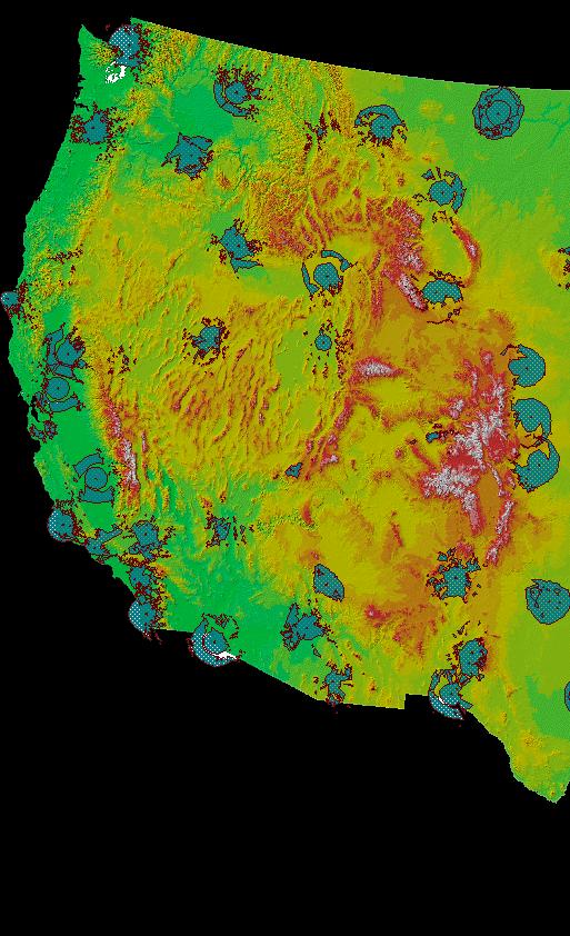
30 Sierra-Nevada Mountain Region Area: 63,100 square kilometers (24,370 sq mi) Length: 400 mile, Width: 64 mile. Source: Google Earth Center for Hydrometeorology and Remote Sensing (CHRS)

31 Sierra-Nevada Mountain (California and Nevada) Center for Hydrometeorology and Remote Sensing (CHRS)

32 Testing of PERSIANN-CDR: Number of Rainy days >= 10 mm/day Center for Hydrometeorology and Remote Sensing (CHRS)
33 Evaluation Indices ID Definition Unit RR95p The 95th percentile of annual precipitation on wet days (precipitation 1mm) mm/day R10mmTOT Annual total precipitation when daily precipitation 10mm mm R10mm Annual count of days when precipitation 10mm Days Extreme precipitation indices used in the analysis


34 Results: Entire China EA PERSIANN-CDR Pixel correlation Scatterplot of mean RR95p R10mmTOT R10mm Miao et al., JHM 2015
 University of California, Irvine Ashouri et")
35 PERSIANN-CDR: Potential Usefulness for Model testing Center for Hydrometeorology Center for Hydrometeorology and Remote & Sensing Remote Sensing, (CHRS) University of California, Irvine Ashouri et al., BAMS 2015


")
36 Future Modeling Scenarios IPCC AR5 RCP2.6 Time period: CNRM-CM5 (France GCM) CSIRO-MK (Australian GCM) GISS-E2-R (U.S. GCM) HadGEM2-ES (U.K. GCM) Dr. Chiyuan Miao - BNU


 RCP8.")

37 Future Modeling Scenarios IPCC AR5 CNRM-CM5 (France GCM) CSIRO-MK (Australian GCM) GISS-E2-R (U.S. GCM) RCP8.5 Time period: HadGEM2-ES (U.K. GCM) Dr. Chiyuan Miao - BNU
 CCSM4 (NCAR, USA GCM)")
 MIROC5 (Japan GCM) MPI-ESM-MR (Germany GCM)")
38 CMIP5 Models historical simulation ( ): CHINA bcc_csm1_1_m (Chinese GCM) CCSM4 (NCAR, USA GCM) HadGEM2-ES (U.K GCM) MIROC5 (Japan GCM) MPI-ESM-MR (Germany GCM) Observation (CRU Dataset) Observation (PERSIANN-CDR)
39 Integration of Satellite & Ground Measurements Bias Adjustment of Satellite Estimation using Gauge Measurements
40 Bias Adjustment of Satellite Estimation Using Gauge Observation Bias adjustment of PERSIANN-CCS Estimation Using Local Gauge Measurements: A Case Study over Chile Gauge Observation 456 gauges are selected Data period: (5 years) Observations (see figures on the right) PERSIANN-CCS Match to the same time period for evaluation Evaluation zones 14 zones are divided by every 2 latitudes over the adjusted region (shown as the right figure) Yang et al., JGR Atmosphere 2016 & 2017
41 F(r): CDF Quantile Mapping of CCS to Gauge Estimation Estimate cumulative distribution of satellite and gauge rainfall estimation at 0.04 o x0.04 o under 1 o x1 o coverage CCS gird 1 o x1 o 0.04 o x0.04 o Gauge Observation F sat (r): CDF of Satellite Estimation F G (r): CDF of Gauge Measurement rainfall (mm/day) R sat : Satellite Estimates R sat-adj : Adjusted Satellite Estimations
42 Step III: Calculate CDF curves of CCS and gauge Estimates 5-year of daily gauge and CCS estimations are collected Estimate the corresponding CDF curve for each 1 o x1 o box for each season (or month) If gauge is not available for a 1 o x1 o box, extend the box size to 3 o x3 o or larger to collect gauge & satellite samples to estimate CDF for that 1 o x1 o box Gauge 456 gauges 98(1 x 1 ) boxes
43 Bias Correction of Monthly Rainfall (5-year average) July October
")
44 Results: Monthly Time Series (Zonal Average: #1, #7, #13)
45 Results: Cumulative Time Series (Zonal Average: #1, #7, #13)
46 Merge Real-time Satellite and Gauge Daily Estimates Merging daily gauge and satellite estimation Merging gauge and bias adjusted CCS estimation based on the uncertainty (RMSE) of estimation CCS gird 1 o x1 o 0.04 o x0.04 o Gauge Observation
47 Monthly Average Rainfall ( ) October
")
48 Results: Monthly Time Series (Zonal Average: #1, #7, #12)
49 Daily Time Series (Zonal Average: #1, #7, #12)
50 PERSIANN Websites and Apps - CHRS irain - CHRS RainSphere - CHRS Data Portal

51 PERSIANN Extensions: Weather-Related CHRS irain An Integrated System for Global Real-time Precipitation Observation

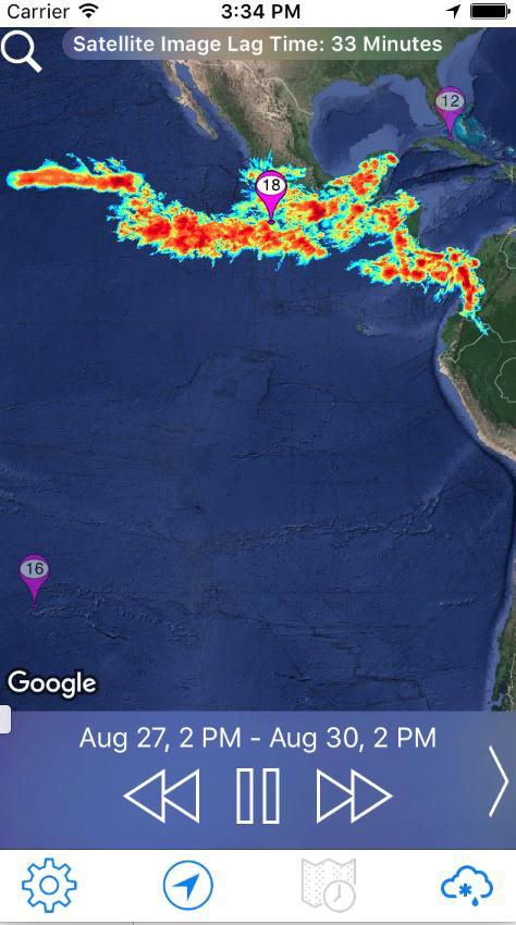
52 CHRS s Real-time Global Extreme Precipitation Events Observation System irain.eng.uci.edu

53 CHRS irain capturing Tropical Storm Harvey - August 2017 irain.eng.uci.edu


54 CHRS irain App
55 PERSIANN Extensions: Climate-Related CHRS RainSphere An Integrated System for Global Satellite Precipitation Data and Information


56 CHRS RainSphere Rainsphere.eng.uci.edu Search Location Map Layers Rain Data Type Rain Layers Rain Comparison Rain Statistics and Trends Legend


57 CHRS RainSphere

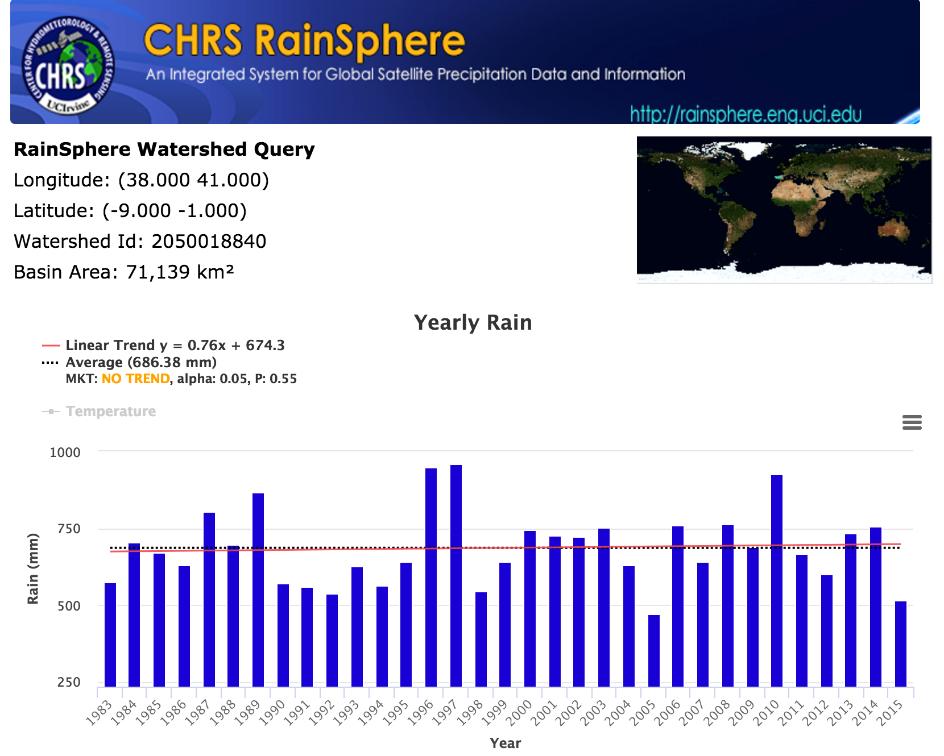
58 CHRS RainSphere


59 CHRS RainSphere


60 CHRS RainSphere Rainsphere.eng.uci.edu Countries Watersheds Political Divisions Major Basins Rainfall Trends Across Spatial Scales

61 CHRS Data Portal

62 Who Uses CHRS Products irain.eng.uci.edu
63 Conclusions Remote sensing precipitation is a way to extend rainfall estimation to regions where ground observations are limited. Operation requirement of precipitation data: - High quality near real-time estimation is needed for hydrologic applications Precipitation Climate Data: PERSIANN-CDR: A more than 30 year daily precipitation data is introduced. PERSIANN-CDR is a very useful source for hydro-climate studies. Integration of Satellite & Ground Measurements Effective use of ground observations to reduce bias of satellite-based estimation CHRS PERSIANN Websites and Data Service PERSIANN related Apps and Data Service are available through CHRS webpage.

64 Gracias por su invitación
Ensuring Water in a Changing World
 Ensuring Water in a Changing World Evaluation and application of satellite-based precipitation measurements for hydro-climate studies over mountainous regions: case studies from the Tibetan Plateau Soroosh
Challenges and Limitations of Hydroclimatological Forecasting and the Relative Role of its Three Pillars: Models, Observations and Parameterization
 Challenges and Limitations of Hydroclimatological Forecasting and the Relative Role of its Three Pillars: Models, Observations and Parameterization Soroosh Sorooshian Center for Hydrometeorology and Remote
Remote sensing of precipitation extremes
 The panel is about: Understanding and predicting weather and climate extreme Remote sensing of precipitation extremes Climate extreme : (JSC meeting, June 30 2014) IPCC SREX report (2012): Climate Ali
2009 Progress Report To The National Aeronautics and Space Administration NASA Energy and Water Cycle Study (NEWS) Program
 Program") 2009 Progress Report To The National Aeronautics and Space Administration NASA Energy and Water Cycle Study (NEWS) Program Proposal Title: Grant Number: PI: The Challenges of Utilizing Satellite Precipitation
2009 Progress Report To The National Aeronautics and Space Administration NASA Energy and Water Cycle Study (NEWS) Program Proposal Title: Grant Number: PI: The Challenges of Utilizing Satellite Precipitation
Director: Soroosh Sorooshian
 Director: Soroosh Sorooshian X. Gao B. Imam K. Hsu S. O Rourke D. Hohnbaum J. Li G.H. Park D. Braithwaite E. Pritchard B. Khakbaz W. Chu A. Behrangi Alex R. Sutlana Joey A. Zahraei Developing state-of-the-art
TRMM Multi-satellite Precipitation Analysis (TMPA)
") TRMM Multi-satellite Precipitation Analysis (TMPA) (sometimes known as 3B42/43, TRMM product numbers) R. Adler, G. Huffman, D. Bolvin, E. Nelkin, D. Wolff NASA/Goddard Laboratory for Atmospheres with key
TRMM Multi-satellite Precipitation Analysis (TMPA) (sometimes known as 3B42/43, TRMM product numbers) R. Adler, G. Huffman, D. Bolvin, E. Nelkin, D. Wolff NASA/Goddard Laboratory for Atmospheres with key
Remote Sensing Applications for Drought Monitoring
 Remote Sensing Applications for Drought Monitoring Amir AghaKouchak Center for Hydrometeorology and Remote Sensing Department of Civil and Environmental Engineering University of California, Irvine Outline
Evaluation of Satellite Precipitation Products over the Central of Vietnam
 Evaluation of Satellite Precipitation Products over the Central of Vietnam Long Trinh-Tuan (1), Jun Matsumoto (1,2), Thanh Ngo-Duc (3) (1) Department of Geography, Tokyo Metropolitan University, Japan.
MAIN ATTRIBUTES OF THE PRECIPITATION PRODUCTS DEVELOPED BY THE HYDROLOGY SAF PROJECT RESULTS OF THE VALIDATION IN HUNGARY
 MAIN ATTRIBUTES OF THE PRECIPITATION PRODUCTS DEVELOPED BY THE HYDROLOGY SAF PROJECT RESULTS OF THE VALIDATION IN HUNGARY Eszter Lábó OMSZ-Hungarian Meteorological Service, Budapest, Hungary labo.e@met.hu
The Global Precipitation Climatology Project (GPCP) CDR AT NOAA: Research to Real-time Climate Monitoring
 CDR AT NOAA: Research to Real-time Climate Monitoring") The Global Precipitation Climatology Project (GPCP) CDR AT NOAA: Research to Real-time Climate Monitoring Robert Adler, Matt Sapiano, Guojun Gu University of Maryland Pingping Xie (NCEP/CPC), George Huffman
The Global Precipitation Climatology Project (GPCP) CDR AT NOAA: Research to Real-time Climate Monitoring Robert Adler, Matt Sapiano, Guojun Gu University of Maryland Pingping Xie (NCEP/CPC), George Huffman
Satellite derived precipitation estimates over Indian region during southwest monsoons
 J. Ind. Geophys. Union ( January 2013 ) Vol.17, No.1, pp. 65-74 Satellite derived precipitation estimates over Indian region during southwest monsoons Harvir Singh 1,* and O.P. Singh 2 1 National Centre
Snowfall Detection and Rate Retrieval from ATMS
 Snowfall Detection and Rate Retrieval from ATMS Jun Dong 1, Huan Meng 2, Cezar Kongoli 1, Ralph Ferraro 2, Banghua Yan 2, Nai-Yu Wang 1, Bradley Zavodsky 3 1 University of Maryland/ESSIC/Cooperative Institute
Global Precipitation Data Sets
 Global Precipitation Data Sets Rick Lawford (with thanks to Phil Arkin, Scott Curtis, Kit Szeto, Ron Stewart, etc) April 30, 2009 Toronto Roles of global precipitation products in drought studies: 1.Understanding
Operational quantitative precipitation estimation using radar, gauge g and
 Operational quantitative precipitation estimation using radar, gauge g and satellite for hydrometeorological applications in Southern Brazil Leonardo Calvetti¹, Cesar Beneti¹, Diogo Stringari¹, i¹ Alex
P4.4 THE COMBINATION OF A PASSIVE MICROWAVE BASED SATELLITE RAINFALL ESTIMATION ALGORITHM WITH AN IR BASED ALGORITHM
 P4.4 THE COMBINATION OF A PASSIVE MICROWAVE BASED SATELLITE RAINFALL ESTIMATION ALGORITHM WITH AN IR BASED ALGORITHM Robert Joyce 1), John E. Janowiak 2), and Phillip A. Arkin 3, Pingping Xie 2) 1) RS
The Status of NOAA/NESDIS Precipitation Algorithms and Products
 The Status of NOAA/NESDIS Precipitation Algorithms and Products Ralph Ferraro NOAA/NESDIS College Park, MD USA S. Boukabara, E. Ebert, K. Gopalan, J. Janowiak, S. Kidder, R. Kuligowski, H. Meng, M. Sapiano,
School on Modelling Tools and Capacity Building in Climate and Public Health April Remote Sensing
 2453-5 School on Modelling Tools and Capacity Building in Climate and Public Health 15-26 April 2013 Remote Sensing CECCATO Pietro International Research Institute for Climate and Society, IRI The Earth
Spaceborne and Ground-based Global and Regional Precipitation Estimation: Multi-Sensor Synergy
 Hydrometeorology and Remote Sensing Lab (hydro.ou.edu) at The University of Oklahoma Spaceborne and Ground-based Global and Regional Precipitation Estimation: Multi-Sensor Synergy Presented by: 温逸馨 (Berry)
School on Modelling Tools and Capacity Building in Climate and Public Health April Rainfall Estimation
 2453-6 School on Modelling Tools and Capacity Building in Climate and Public Health 15-26 April 2013 Rainfall Estimation CECCATO Pietro International Research Institute for Climate and Society, IRI The
H-SAF future developments on Convective Precipitation Retrieval
 H-SAF future developments on Convective Precipitation Retrieval Francesco Zauli 1, Daniele Biron 1, Davide Melfi 1, Antonio Vocino 1, Massimiliano Sist 2, Michele De Rosa 2, Matteo Picchiani 2, De Leonibus
NEW SCHEME TO IMPROVE THE DETECTION OF RAINY CLOUDS IN PUERTO RICO
 NEW SCHEME TO IMPROVE THE DETECTION OF RAINY CLOUDS IN PUERTO RICO Joan Manuel Castro Sánchez Advisor Dr. Nazario Ramirez UPRM NOAA CREST PRYSIG 2016 October 7, 2016 Introduction A cloud rainfall event
Intermittency in precipitation: duration, frequency, intensity and amounts using hourly data
 Intermittency in precipitation: duration, frequency, intensity and amounts using hourly data Kevin E Trenberth with Yongxin Zhang and Maria Gehne NCAR How should rainfall change as climate changes? Usually
QPE and QPF in the Bureau of Meteorology
 QPE and QPF in the Bureau of Meteorology Current and future real-time rainfall products Carlos Velasco (BoM) Alan Seed (BoM) and Luigi Renzullo (CSIRO) OzEWEX 2016, 14-15 December 2016, Canberra Why do
Precipitation Estimation from Remotely Sensed Imagery Using an Artificial Neural Network Cloud Classification System
 1834 JOURNAL OF APPLIED METEOROLOGY Precipitation Estimation from Remotely Sensed Imagery Using an Artificial Neural Network Cloud Classification System YANG HONG Department of Hydrology and Water Resources,
THE EVALUATION OF A PASSIVE MICROWAVE-BASED SATELLITE RAINFALL ESTIMATION ALGORITHM WITH AN IR BASED ALGORITHM AT SHORT TIME SCALES
 THE EVALUATION OF A PASSIVE MICROWAVE-BASED SATELLITE RAINFALL ESTIMATION ALGORITHM WITH AN IR BASED ALGORITHM AT SHORT TIME SCALES Robert Joyce 1, John E. Janowiak 2, Phillip A. Arkin 3, Pingping Xie
Supplementary Figure 1 Current and future distribution of temperate drylands. (a b-f b-f
 Supplementary Figure 1 Current and future distribution of temperate drylands. (a) Five temperate dryland regions with their current extent for 1980-2010 (green): (b) South America; (c) North America; (d)
Analyzing and Visualizing Precipitation and Soil Moisture in ArcGIS
 Analyzing and Visualizing Precipitation and Soil Moisture in ArcGIS Wenli Yang, Pham Long, Peisheng Zhao, Steve Kempler, and Jennifer Wei * NASA Goddard Earth Science Data and Information Services Center
Welcome and Introduction
 Welcome and Introduction Riko Oki Earth Observation Research Center (EORC) Japan Aerospace Exploration Agency (JAXA) 7th Workshop of International Precipitation Working Group 17 November 2014 Tsukuba International
Status of the GeoKompsat-2A AMI rainfall rate algorithm
 Status of the GeoKompsat-2A AMI rainfall rate algorithm Dong-Bin Shin, Damwon So, Hyo-Jin Park Department of Atmospheric Sciences, Yonsei University Algorithm Strategy Well-known assumption in IR-based
REFAME: Rain Estimation Using Forward-Adjusted Advection of Microwave Estimates
 DECEMBER 2010 B E H R A N G I E T A L. 1305 REFAME: Rain Estimation Using Forward-Adjusted Advection of Microwave Estimates ALI BEHRANGI,* BISHER IMAM, KUOLIN HSU, AND SOROOSH SOROOSHIAN Center for Hydrometeorology
Lecture 19: Operational Remote Sensing in Visible, IR, and Microwave Channels
 MET 4994 Remote Sensing: Radar and Satellite Meteorology MET 5994 Remote Sensing in Meteorology Lecture 19: Operational Remote Sensing in Visible, IR, and Microwave Channels Before you use data from any
Uncertainty quantification of satellite precipitation estimation and Monte Carlo assessment of the error propagation into hydrologic response
 Click Here for Full Article WATER RESOURCES RESEARCH, VOL. 42,, doi:10.1029/2005wr004398, 2006 Uncertainty quantification of satellite precipitation estimation and Monte Carlo assessment of the error propagation
INTERNATIONAL PRECIPITATION WORKING GROUP (IPWG): INTER-COMPARISON OF REGIONAL PRECIPITATION PRODUCTS
: INTER-COMPARISON OF REGIONAL PRECIPITATION PRODUCTS") INTERNATIONAL PRECIPITATION WORKING GROUP (IPWG): INTER-COMPARISON OF REGIONAL PRECIPITATION PRODUCTS Kidd C 1, Heinemann T 2, Levizzani V 3, and Kniveton D.R 4. 1 School of Geography, Earth and Environmental
INTERNATIONAL PRECIPITATION WORKING GROUP (IPWG): INTER-COMPARISON OF REGIONAL PRECIPITATION PRODUCTS Kidd C 1, Heinemann T 2, Levizzani V 3, and Kniveton D.R 4. 1 School of Geography, Earth and Environmental
Projection Results from the CORDEX Africa Domain
 Projection Results from the CORDEX Africa Domain Patrick Samuelsson Rossby Centre, SMHI patrick.samuelsson@smhi.se Based on presentations by Grigory Nikulin and Erik Kjellström CORDEX domains over Arab
Evaluation of the Version 7 TRMM Multi-Satellite Precipitation Analysis (TMPA) 3B42 product over Greece
 3B42 product over Greece") 15 th International Conference on Environmental Science and Technology Rhodes, Greece, 31 August to 2 September 2017 Evaluation of the Version 7 TRMM Multi-Satellite Precipitation Analysis (TMPA) 3B42
15 th International Conference on Environmental Science and Technology Rhodes, Greece, 31 August to 2 September 2017 Evaluation of the Version 7 TRMM Multi-Satellite Precipitation Analysis (TMPA) 3B42
Retrieval of precipitation from Meteosat-SEVIRI geostationary satellite observations
 Retrieval of precipitation from Meteosat-SEVIRI geostationary satellite observations Jan Fokke Meirink, Hidde Leijnse (KNMI) Rob Roebeling (EUMETSAT) Overview Introduction Algorithm description Validation
The Evaluation of Precipitation Information from Satellites and Models
 The Evaluation of Precipitation Information from Satellites and Models Mathew R P Sapiano University of Maryland msapiano@umd.edu 1 Validation activities at CICS/UMD Continuation of daily IPWG validation
More extreme precipitation in the world s dry and wet regions
 More extreme precipitation in the world s dry and wet regions Markus G. Donat, Andrew L. Lowry, Lisa V. Alexander, Paul A. O Gorman, Nicola Maher Supplementary Table S1: CMIP5 simulations used in this
Global Flood Alert System based on satellite derived rainfall data -Targeting the era of Global Precipitation Measurement (GPM)-
-") Global Flood Alert System based on satellite derived rainfall data -Targeting the era of Global Precipitation Measurement (GPM)- Riko Oki, Misako Kachi (JAXA/EORC) Kazuhiko Fukami (PWRI) and Kazuo Umeda
Global Flood Alert System based on satellite derived rainfall data -Targeting the era of Global Precipitation Measurement (GPM)- Riko Oki, Misako Kachi (JAXA/EORC) Kazuhiko Fukami (PWRI) and Kazuo Umeda
Overview and Access to GPCP, TRMM, and GPM Precipitation Data Products
 National Aeronautics and Space Administration ARSET Applied Remote Sensing Training http://arset.gsfc.nasa.gov @NASAARSET Overview and Access to GPCP, TRMM, and GPM Precipitation Data Products www.nasa.gov
NASA Flood Monitoring and Mapping Tools
 National Aeronautics and Space Administration ARSET Applied Remote Sensing Training http://arset.gsfc.nasa.gov @NASAARSET NASA Flood Monitoring and Mapping Tools www.nasa.gov Outline Overview of Flood
Global Satellite Products & Services for Agricultural and Vegetation Health
 Global Satellite Products & Services for Agricultural and Vegetation Health Presented at the WMO Expert Meeting on National Early Warning System for Agricultural Weather Management George Mason University
Future freshwater stress for island populations
 Future freshwater stress for island populations Kristopher B. Karnauskas, Jeffrey P. Donnelly and Kevin J. Anchukaitis Summary: Top left: Overview map of the four island stations located in the U.S. state
Remote Sensing of Precipitation
 Lecture Notes Prepared by Prof. J. Francis Spring 2003 Remote Sensing of Precipitation Primary reference: Chapter 9 of KVH I. Motivation -- why do we need to measure precipitation with remote sensing instruments?
Evaluation of GPM Precipitation Estimates for Land Data Assimilation Applications
 Evaluation of GPM Precipitation Estimates for Land Data Assimilation Applications PI: Prof. Lori Bruce, Ph.D Mississippi State University GeoResources Institute RPC Review (04/14/08) 1 GPM Evaluation Team
GPM-GSMaP data is now available from JAXA G-portal (https://www.gportal.jaxa.jp) as well as current GSMaP web site (http://sharaku.eorc.jaxa.
 as well as current GSMaP web site (http://sharaku.eorc.jaxa.") GPM-GSMaP data is now available from JAXA G-portal (https://www.gportal.jaxa.jp) as well as current GSMaP web site (http://sharaku.eorc.jaxa.jp/ GSMaP/). GPM Core GMI TRMM PR GPM era Precipitation Radar
GPM-GSMaP data is now available from JAXA G-portal (https://www.gportal.jaxa.jp) as well as current GSMaP web site (http://sharaku.eorc.jaxa.jp/ GSMaP/). GPM Core GMI TRMM PR GPM era Precipitation Radar
The JRA-55 Reanalysis: quality control and reprocessing of observational data
 The JRA-55 Reanalysis: quality control and reprocessing of observational data Kazutoshi Onogi On behalf of JRA group Japan Meteorological Agency 29 October 2014 EASCOF 1 1. Introduction 1. Introduction
EVALUATION OF SATELLITE-DERIVED HIGH RESOLUTION RAINFALL ESTIMATES OVER EASTERN SÃO PAULO AND PARANÁ,, BRAZIL
 EVALUATION OF SATELLITE-DERIVED HIGH RESOLUTION RAINFALL ESTIMATES OVER EASTERN SÃO PAULO AND PARANÁ,, BRAZIL Augusto J. Pereira Filho 1 Phillip Arkin 2 Joe Turk 3 John E. Janowiak 4 Cesar Beneti 5 Leonardo
APPENDIX 2 OVERVIEW OF THE GLOBAL PRECIPITATION MEASUREMENT (GPM) AND THE TROPICAL RAINFALL MEASURING MISSION (TRMM) 2-1
 AND THE TROPICAL RAINFALL MEASURING MISSION (TRMM) 2-1") APPENDIX 2 OVERVIEW OF THE GLOBAL PRECIPITATION MEASUREMENT (GPM) AND THE TROPICAL RAINFALL MEASURING MISSION (TRMM) 2-1 1. Introduction Precipitation is one of most important environmental parameters.
APPENDIX 2 OVERVIEW OF THE GLOBAL PRECIPITATION MEASUREMENT (GPM) AND THE TROPICAL RAINFALL MEASURING MISSION (TRMM) 2-1 1. Introduction Precipitation is one of most important environmental parameters.
LMODEL: A Satellite Precipitation Methodology Using Cloud Development Modeling. Part II: Validation
 1096 J O U R N A L O F H Y D R O M E T E O R O L O G Y VOLUME 10 LMODEL: A Satellite Precipitation Methodology Using Cloud Development Modeling. Part II: Validation KUO-LIN HSU University of California,
The challenge of predicting flash floods from thunderstorm rainfall
 10.1098/rsta.2002.1015 The challenge of predicting flash floods from thunderstorm rainfall By Hosin Gupta, Soroosh Sorooshian, Xiaogang Gao, Bisher Imam, Kuo-Lin Hsu, Luis Bastidas, Jailun Li and Shayesteh
Judit Kerényi. OMSZ - Hungarian Meteorological Service, Budapest, Hungary. H-1525 Budapest, P.O.Box 38, Hungary.
 SATELLITE-DERIVED PRECIPITATION ESTIMATIONS DEVELOPED BY THE HYDROLOGY SAF PROJECT CASE STUDIES FOR THE INVESTIGATION OF THEIR ACCURACY AND FEATURES IN HUNGARY Judit Kerényi OMSZ - Hungarian Meteorological
Multiple data fusion for rainfall estimation using a NARX-based recurrent neural network the development of the REIINN model
 IOP Conference Series: Earth and Environmental Science OPEN ACCESS Multiple data fusion for rainfall estimation using a NARX-based recurrent neural network the development of the REIINN model To cite this
Climate Change Impact on Intensity-Duration- Frequency Curves in Ho Chi Minh city
 Climate Change Impact on Intensity-Duration- Frequency Curves in Ho Chi Minh city Khiem Van Mai, Minh Truong Ha, Linh Nhat Luu Institute of Meteorology, Hydrology and Climate Change, Hanoi, Vietnam Hanoi,
Evaluation of the PERSIANN-CDR Daily Rainfall Estimates in Capturing the Behavior of Extreme Precipitation Events over China
 JUNE 2015 M I A O E T A L. 1387 Evaluation of the PERSIANN-CDR Daily Rainfall Estimates in Capturing the Behavior of Extreme Precipitation Events over China CHIYUAN MIAO State Key Laboratory of Earth Surface
The GOES-R Rainfall Rate, Rainfall Potential, and Probability of Rainfall Algorithms
 The GOES-R Rainfall Rate, Rainfall Potential, and Probability of Rainfall Algorithms Bob Kuligowski, NOAA/NESDIS/STAR Yaping Li, Zhihua Zhang, Richard Barnhill, I. M. Systems Group 5 th International Precipitation
Retrieving Snowfall Rate with Satellite Passive Microwave Measurements
 Retrieving Snowfall Rate with Satellite Passive Microwave Measurements Huan Meng 1, Ralph Ferraro 1, Banghua Yan 1, Cezar Kongoli 2, Nai-Yu Wang 2, Jun Dong 2, Limin Zhao 1 1 NOAA/NESDIS, USA 2 Earth System
A Statistical Model for the Uncertainty Analysis of Satellite Precipitation Products
 OCTOBER 2015 S A R A C H I E T A L. 2101 A Statistical Model for the Uncertainty Analysis of Satellite Precipitation Products SEPIDEH SARACHI, KUO-LIN HSU, AND SOROOSH SOROOSHIAN Center for Hydrometeorology
TAMSAT: LONG-TERM RAINFALL MONITORING ACROSS AFRICA
 TAMSAT: LONG-TERM RAINFALL MONITORING ACROSS AFRICA Ross Maidment, Emily Black, Matthew Young and Dagmawi Asfaw TAMSAT, University of Reading Helen Greatrex IRI, Columbia University 13 th EUMETSAT User
Downscaled Climate Change Projection for the Department of Energy s Savannah River Site
 Downscaled Climate Change Projection for the Department of Energy s Savannah River Site Carolinas Climate Resilience Conference Charlotte, North Carolina: April 29 th, 2014 David Werth Atmospheric Technologies
for the Global Precipitation Mission
 A Physically based Rainfall Rate Algorithm for the Global Precipitation Mission Kevin Garrett 1, Leslie Moy 1, Flavio Iturbide Sanchez 1, and Sid Ahmed Boukabara 2 5 th IPWG Workshop Hamburg, Germany October
H SAF SATELLITE APPLICATION FACILITY ON SUPPORT TO OPERATIONAL HYDROLOGY AND WATER MANAGEMENT EUMETSAT NETWORK OF SATELLITE APPLICATION FACILITIES
 H SAF SATELLITE APPLICATION FACILITY ON SUPPORT TO OPERATIONAL HYDROLOGY AND WATER MANAGEMENT EUMETSAT NETWORK OF SATELLITE APPLICATION FACILITIES H-SAF: SATELLITE PRODUCTS FOR OPERATIONAL HYDROLOGY H-SAF
REQUIREMENTS FOR WEATHER RADAR DATA. Review of the current and likely future hydrological requirements for Weather Radar data
 WORLD METEOROLOGICAL ORGANIZATION COMMISSION FOR BASIC SYSTEMS OPEN PROGRAMME AREA GROUP ON INTEGRATED OBSERVING SYSTEMS WORKSHOP ON RADAR DATA EXCHANGE EXETER, UK, 24-26 APRIL 2013 CBS/OPAG-IOS/WxR_EXCHANGE/2.3
S16. ASSESSING THE CONTRIBUTIONS OF EAST AFRICAN AND WEST PACIFIC WARMING TO THE 2014 BOREAL SPRING EAST AFRICAN DROUGHT
 S6. ASSESSING THE CONTRIBUTIONS OF EAST AFRICAN AND WEST PACIFIC WARMING TO THE 204 BOREAL SPRING EAST AFRICAN DROUGHT Chris Funk, Shraddhanand Shukla, Andy Hoell, and Ben Livneh This document is a supplement
INVESTIGATING THE SIMULATIONS OF HYDROLOGICAL and ENERGY CYCLES OF IPCC GCMS OVER THE CONGO AND UPPER BLUE NILE BASINS
 INVESTIGATING THE SIMULATIONS OF HYDROLOGICAL and ENERGY CYCLES OF IPCC GCMS OVER THE CONGO AND UPPER BLUE NILE BASINS Mohamed Siam, and Elfatih A. B. Eltahir. Civil & Environmental Engineering Department,
MULTI MODEL ENSEMBLE FOR ASSESSING THE IMPACT OF CLIMATE CHANGE ON THE HYDROLOGY OF A SOUTH INDIAN RIVER BASIN
 MULTI MODEL ENSEMBLE FOR ASSESSING THE IMPACT OF CLIMATE CHANGE ON THE HYDROLOGY OF A SOUTH INDIAN RIVER BASIN P.S. Smitha, B. Narasimhan, K.P. Sudheer Indian Institute of Technology, Madras 2017 International
Development of Innovative Technology to Provide Low-Cost Surface Atmospheric Observations in Data-sparse Regions
 Development of Innovative Technology to Provide Low-Cost Surface Atmospheric Observations in Data-sparse Regions Paul Kucera and Martin Steinson University Corporation for Atmospheric Research/COMET 3D-Printed
The Implication of Ural Blocking on the East Asian Winter Climate in CMIP5 Models
 The Implication of Ural Blocking on the East Asian Winter Climate in CMIP5 Models Hoffman H. N. Cheung, Wen Zhou (hncheung-c@my.cityu.edu.hk) City University of Hong Kong Shenzhen Institute Guy Carpenter
Lecture 4b: Meteorological Satellites and Instruments. Acknowledgement: Dr. S. Kidder at Colorado State Univ.
 Lecture 4b: Meteorological Satellites and Instruments Acknowledgement: Dr. S. Kidder at Colorado State Univ. US Geostationary satellites - GOES (Geostationary Operational Environmental Satellites) US
Twenty-first-century projections of North Atlantic tropical storms from CMIP5 models
 SUPPLEMENTARY INFORMATION DOI: 10.1038/NCLIMATE1530 Twenty-first-century projections of North Atlantic tropical storms from CMIP5 models SUPPLEMENTARY FIGURE 1. Annual tropical Atlantic SST anomalies (top
Judit Kerényi. OMSZ-Hungarian Meteorological Service P.O.Box 38, H-1525, Budapest Hungary Abstract
 Comparison of the precipitation products of Hydrology SAF with the Convective Rainfall Rate of Nowcasting-SAF and the Multisensor Precipitation Estimate of EUMETSAT Judit Kerényi OMSZ-Hungarian Meteorological
CARFFG System Development and Theoretical Background
 CARFFG Steering Committee Meeting 15 SEPTEMBER 2015 Astana, KAZAKHSTAN CARFFG System Development and Theoretical Background Theresa M. Modrick, PhD Hydrologic Research Center Key Technical Components -
Generating Multi-Sensor Precipitation Estimates over Radar Gap Areas
 Generating Multi-Sensor Precipitation Estimates over Radar Gap Areas SHAYESTEH E. MAHANI and REZA KHANBILVARDI Civil Engineering Department City University of New York (CUNY) & Cooperative Remote Sensing
COMBINATION OF SATELLITE PRECIPITATION ESTIMATES AND RAIN GAUGE FOR HIGH SPATIAL AND TEMPORAL RESOLUTIONS INTRODUCTION
 COMBINATION OF SATELLITE PRECIPITATION ESTIMATES AND RAIN GAUGE FOR HIGH SPATIAL AND TEMPORAL RESOLUTIONS Ferreira, Rute Costa¹ ; Herdies, D. L.¹; Vila, D.A.¹; Beneti, C.A. A.² ¹ Center for Weather Forecasts
Overview of Data for CREST Model
 Overview of Data for CREST Model Xianwu Xue April 2 nd 2012 CREST V2.0 CREST V2.0 Real-Time Mode Forcasting Mode Data Assimilation Precipitation PET DEM, FDR, FAC, Slope Observed Discharge a-priori parameter
A statistical approach for rainfall confidence estimation using MSG-SEVIRI observations
 A statistical approach for rainfall confidence estimation using MSG-SEVIRI observations Elisabetta Ricciardelli*, Filomena Romano*, Nico Cimini*, Frank Silvio Marzano, Vincenzo Cuomo* *Institute of Methodologies
Global Rainfall Map Realtime version (GSMaP_NOW) Data Format Description
 Data Format Description") updated 01 November 2018 2 November 2015 Global Rainfall Map Realtime version (GSMaP_NOW) Data Format Description This document describes data format and information of Global Rainfall Map Realtime version
updated 01 November 2018 2 November 2015 Global Rainfall Map Realtime version (GSMaP_NOW) Data Format Description This document describes data format and information of Global Rainfall Map Realtime version
A MODEL IN SPATIAL AND TEMPORAL DOMAIN TO PREDICT RADAR RAINFALL DATA
 A MODEL IN SPATIAL AND TEMPORAL DOMAIN TO PREDICT RADAR RAINFALL DATA Nazario D. Ramirez-Beltran, Luz Torres Molina, Joan M. Castro, Sandra Cruz-Pol, José G. Colom-Ustáriz and Nathan Hosanna PRYSIG 2014
The assimilation of AMSU and SSM/I brightness temperatures in clear skies at the Meteorological Service of Canada
 The assimilation of AMSU and SSM/I brightness temperatures in clear skies at the Meteorological Service of Canada Abstract David Anselmo and Godelieve Deblonde Meteorological Service of Canada, Dorval,
Water Stress, Droughts under Changing Climate
 Water Stress, Droughts under Changing Climate Professor A.K.M. Saiful Islam Institute of Water and Flood Management Bangladesh University of Engineering and Technology (BUET) Outline of the presentation
Application of Radar QPE. Jack McKee December 3, 2014
 Application of Radar QPE Jack McKee December 3, 2014 Topics Context Precipitation Estimation Techniques Study Methodology Preliminary Results Future Work Questions Introduction Accurate precipitation data
Abebe Sine Gebregiorgis, PhD Postdoc researcher. University of Oklahoma School of Civil Engineering and Environmental Science
 Abebe Sine Gebregiorgis, PhD Postdoc researcher University of Oklahoma School of Civil Engineering and Environmental Science November, 2014 MAKING SATELLITE PRECIPITATION PRODUCTS WORK FOR HYDROLOGIC APPLICATION
Comparison of satellite rainfall estimates with raingauge data for Africa
 Comparison of satellite rainfall estimates with raingauge data for Africa David Grimes TAMSAT Acknowledgements Ross Maidment Teo Chee Kiat Gulilat Tefera Diro TAMSAT = Tropical Applications of Meteorology
CLOUD PATCH-BASED RAINFALL ESTIMATION USING A SATELLITE IMAGE CLASSIFICATION APPROACH
 CLOUD PATCH-BASED RAINFALL ESTIMATION USING A SATELLITE IMAGE CLASSIFICATION APPROACH Yang Hong, Kuo-lin Hsu, and Soroosh Sorooshian Center for Hydrometeorology and Remote Sensing, Department of Civil
Severe storms over the Mediterranean Sea: A satellite and model analysis
 National Research Council of Italy Severe storms over the Mediterranean Sea: A satellite and model analysis V. Levizzani, S. Laviola, A. Malvaldi, M. M. Miglietta, and E. Cattani 6 th International Precipitation
Changes in the El Nino s spatial structure under global warming. Sang-Wook Yeh Hanyang University, Korea
 Changes in the El Nino s spatial structure under global warming Sang-Wook Yeh Hanyang University, Korea Changes in El Nino spatial structure Yeh et al. (2009) McPhaden et al. (2009) Why the spatial structure
SNOWFALL RATE RETRIEVAL USING AMSU/MHS PASSIVE MICROWAVE DATA
 SNOWFALL RATE RETRIEVAL USING AMSU/MHS PASSIVE MICROWAVE DATA Huan Meng 1, Ralph Ferraro 1, Banghua Yan 2 1 NOAA/NESDIS/STAR, 5200 Auth Road Room 701, Camp Spring, MD, USA 20746 2 Perot Systems Government
NOAA/NESDIS Tropical Web Page with LEO Satellite Products and Applications for Forecasters
 NOAA/NESDIS Tropical Web Page with LEO Satellite Products and Applications for Forecasters Sheldon Kusselson National Oceanic and Atmospheric Administration (NOAA) National Environmental Satellite Data
Supplementary Figure 1 A figure of changing surface air temperature and top-1m soil moisture: (A) Annual mean surface air temperature, and (B) top
 Annual mean surface air temperature, and (B) top") Supplementary Figure 1 A figure of changing surface air temperature and top-1m soil moisture: (A) Annual mean surface air temperature, and (B) top 1-m soil moisture averaged over California from CESM1.
Supplementary Figure 1 A figure of changing surface air temperature and top-1m soil moisture: (A) Annual mean surface air temperature, and (B) top 1-m soil moisture averaged over California from CESM1.
The Australian Operational Daily Rain Gauge Analysis
 The Australian Operational Daily Rain Gauge Analysis Beth Ebert and Gary Weymouth Bureau of Meteorology Research Centre, Melbourne, Australia e.ebert@bom.gov.au Daily rainfall data and analysis procedure
On the ability of CMIP3 and CMIP5 models in representing Caribbean current climate
 On the ability of CMIP3 and CMIP5 models in representing Caribbean current climate Sullyandro Oliveira Guimarães sullyandro@gmail.com Alexandre Araújo Costa Domingo Cassain Sales Universidade Estadual
Using Independent NCDC Gauges to Analyze Precipitation Values from the OneRain Corporation Algorithm and the National Weather Service Procedure
 Using Independent NCDC Gauges to Analyze Precipitation Values from the OneRain Corporation Algorithm and the National Weather Service Procedure Steven M. Martinaitis iti Henry E. Fuelberg John L. Sullivan
Supplementary Information for Impacts of a warming marginal sea on torrential rainfall organized under the Asian summer monsoon
 1 2 3 4 5 6 7 8 9 10 11 Supplementary Information for Impacts of a warming marginal sea on torrential rainfall organized under the Asian summer monsoon 12 13 14 Atsuyoshi Manda 1, Hisashi Nakamura 2,4,
Passive and Active Microwave Sensors for Precipitation Research
 Passive and Active Microwave Sensors for Precipitation Research Joe Turk Jet Propulsion Laboratory California Institute of Technology Pasadena, CA jturk@jpl.nasa.gov Characteristics of Precipitation Wide
Detailed Storm Rainfall Analysis for Hurricane Ivan Flooding in Georgia Using the Storm Precipitation Analysis System (SPAS) and NEXRAD Weather Radar
 and NEXRAD Weather Radar") Detailed Storm Rainfall Analysis for Hurricane Ivan Flooding in Georgia Using the Storm Precipitation Analysis System (SPAS) and NEXRAD Weather Radar Ed Tomlinson, PhD and Bill Kappel Applied Weather Associates
Detailed Storm Rainfall Analysis for Hurricane Ivan Flooding in Georgia Using the Storm Precipitation Analysis System (SPAS) and NEXRAD Weather Radar Ed Tomlinson, PhD and Bill Kappel Applied Weather Associates
GSMaP - Integrated application with developer and user collaboration -
 WIGOS WORKSHOP 2019 Session 2.2 GSMaP - Integrated application with developer and user collaboration - Takuji Kubota and Moeka Yamaji Earth Observation Research Center (EORC) Japan Aerospace Exploration
VALIDATION OF SATELLITE PRECIPITATION (TRMM 3B43) IN ECUADORIAN COASTAL PLAINS, ANDEAN HIGHLANDS AND AMAZONIAN RAINFOREST
 IN ECUADORIAN COASTAL PLAINS, ANDEAN HIGHLANDS AND AMAZONIAN RAINFOREST") VALIDATION OF SATELLITE PRECIPITATION (TRMM 3B43) IN ECUADORIAN COASTAL PLAINS, ANDEAN HIGHLANDS AND AMAZONIAN RAINFOREST D. Ballari a, *, E. Castro a, L. Campozano b,c a Civil Engineering Department.
VALIDATION OF SATELLITE PRECIPITATION (TRMM 3B43) IN ECUADORIAN COASTAL PLAINS, ANDEAN HIGHLANDS AND AMAZONIAN RAINFOREST D. Ballari a, *, E. Castro a, L. Campozano b,c a Civil Engineering Department.
Correcting Microwave Precipitation Retrievals for near- Surface Evaporation
 Correcting Microwave Precipitation Retrievals for near- Surface Evaporation The MIT Faculty has made this article openly available. Please share how this access benefits you. Your story matters. Citation
AMS copyrighted work
 AMS copyrighted work Copyright 2014 American Meteorological Society (AMS). Permission to use figures, tables, and brief excerpts from this work in scientific and educational works is hereby granted provided
DERIVED FROM SATELLITE DATA
 P6.17 INTERCOMPARISON AND DIAGNOSIS OF MEI-YU RAINFALL DERIVED FROM SATELLITE DATA Y. Zhou * Department of Meteorology, University of Maryland, College Park, Maryland P. A. Arkin ESSIC, University of Maryland,