GPM-GSMaP data is now available from JAXA G-portal ( as well as current GSMaP web site (
|
|
|
- William Collins
- 6 years ago
- Views:
Transcription


1
 as well as current GSMaP web site (http://sharaku.eorc.jaxa.jp/ GSMaP/).")
2 GPM-GSMaP data is now available from JAXA G-portal ( as well as current GSMaP web site ( GSMaP/).


3 GPM Core GMI TRMM PR GPM era Precipitation Radar Good: can observe vertical structure. Bad: there are not many. Rainfall Data Base Microwave Imager / Sounder GCOM-W1 AMSR2 DMSP SSM/I, SSMIS GSMaP Microwave Radiometer Algorithms Rainfall Data from each Microwave Radiometer Merged Microwave Rainfall Data (Okamoto et al. 2005, Kubota et al, 2007, Aonashi et al. 2009, Ushio et al. 2009, Shige et al. 2009, Kachi et al. 2011, Mega et al., 2014, etc.) NOAA/MetOp AMSU (sounder) Good: highfrequent (wide swath, multisatellites) Bad: cannot measure vertical structure (need info. from radar) IR Imager Geostationary Satellites Microwave-IR Merged Algorithm (CMV, K/F) GSMaP_MVK (satellite-only) GSMaP_Gauge (0.1x0.1 deg. box, Hourly)


4 Cloud motion vectors
5 Standard product (Latency: 3 days) Near-real-time product (Latency: 4 hours)
6
")
 DPR")
7 TRMM-era GSMaP (without GMI) GPM-era GSMaP (with GMI) DPR observation

8 TRMM/TMI GCOM-W/AMSR2 DMSP-F18/SSMIS NOAA-N19/AMSU/MHS GPM Core/GMI EORC/JAXA is developing GMI Tb bias correction (Okuyama, Imaoka et al.)


9 GSMaP_MVK GSMaP_Gauge GSMaP_NRT (FW) MWR Merged TRMMPR 3A25 Reference NOAA/CPC daily Gauge Analysis
10 GSMaP_MVK GSMaP_Gauge GSMaP_NRT MWR Merged PR 3A25 CPC Gauge GSMaP_MVK GSMaP_NRT MWR Merged PR 3A25 Land Ocean


11 was compared with JMA s Radar GSMaP_MVK GSMaP_Gauge Gauge-Radar Analysis JMA radar coverage RMSE=0.35mm/h Corr.=0.825 RMSE=0.16mm/h Corr.=0.871 GSMaP_Gauge shows better correlation with less Root Mean Square Error (RMSE) on 12 th Apr
12 GSMaP_MVK GSMaP_Gauge TRMM-GSMaP_NRT Mean RMSE (Apr.-Jun. 2014) GSMaP_MVK: 0.33 mm/h GSMaP_Gauge: 0.29 mm/h TRMM-GSMaP_NRT: 0.35 mm/h
")
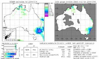
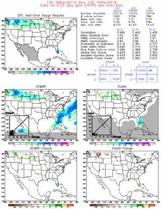
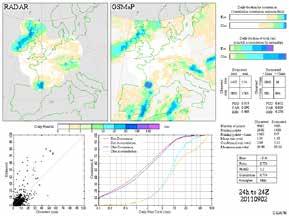
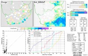
13 The GSMaP joins the International Precipitation Working Group (IPWG) validation activities. We validates various satellite estimates around Japan. Our GSMaP products are validated in U.S.(J.-J.Wang/J. Janowiak), Australia (E. Ebert ), South America (D. Vila), Europe (C. Kidd), South Africa (E. Becker) and Japan (S. Shige).

14 Fixed DB Current TRMM/PR-based Database (DB) Use DB based on TRMM/PR obs. Fixed DB Use DB based on both PR and DPR obs. Mid-to-high latitudes outside PR ranges will be covered by DPR. GPM-era (future; at least 1-year data is needed) Dual-frequency Precipitation Radar (DPR)
 (Murata 2007) Example of direct readout stations")
15 By a network of direct readout stations, ATOVS data can be obtained within 30 minutes of the satellite overpass! An example of Asia-Pacific Regional ATOVS Retransmission Service (AP-RARS) (Murata 2007) Example of direct readout stations Example of AMSU-A NOAA-18
16 RARS METOP-1_AMSU-A METOP-1_MHS METOP-2_AMSU-A METOP-2_MHS NOAA-18_AMSU-A NOAA-18_MHS NOAA-19_AMSU-A NOAA-19_MHS 0% 20% 40% 60% 80% 100% Min. We re now developing the < Almost all data are available within 30 min. from an observation start.


17 We re (Slide by JMA) Launch from the JAXA Tanegashima Space Center by the H-IIA F25 rocket with Himawari-8 onboard on 7 th Oct. 2014
18
Welcome and Introduction
 Welcome and Introduction Riko Oki Earth Observation Research Center (EORC) Japan Aerospace Exploration Agency (JAXA) 7th Workshop of International Precipitation Working Group 17 November 2014 Tsukuba International
Rainfall Observation from Space: A overview of GPM and GSMaP
 Rainfall Observation from Space: A overview of GPM and GSMaP (July 2016 version) Earth Observation Research Center (EORC) Japan Aerospace Exploration Agency (JAXA) Rainfall Measurement and our life Rain
Real-time Global Satellite Mapping of Precipitation (GSMaP) product
 product") Real-time Global Satellite Mapping of Precipitation (GSMaP) product Riko Oki Earth Observation Research Center (EORC) Japan Aerospace Exploration Agency (JAXA) JAXA s Current and Future Satellite/Sensor
Real-time Global Satellite Mapping of Precipitation (GSMaP) product Riko Oki Earth Observation Research Center (EORC) Japan Aerospace Exploration Agency (JAXA) JAXA s Current and Future Satellite/Sensor
Global Rainfall Map Realtime version (GSMaP_NOW) Data Format Description
 Data Format Description") updated 01 November 2018 2 November 2015 Global Rainfall Map Realtime version (GSMaP_NOW) Data Format Description This document describes data format and information of Global Rainfall Map Realtime version
updated 01 November 2018 2 November 2015 Global Rainfall Map Realtime version (GSMaP_NOW) Data Format Description This document describes data format and information of Global Rainfall Map Realtime version
Global Rainfall Map in Near Real Time (GSMaP_NRT) and Gauge-calibrated Rainfall Product (GSMaP_Gauge) Data Format Description
 and Gauge-calibrated Rainfall Product (GSMaP_Gauge) Data Format Description") Global Rainfall Map in Near Real Time (GSMaP_NRT) and Gauge-calibrated Rainfall Product (GSMaP_Gauge) Data Format Description updated 25 July 2017 10 October 2008 This document describes data format and
Global Rainfall Map in Near Real Time (GSMaP_NRT) and Gauge-calibrated Rainfall Product (GSMaP_Gauge) Data Format Description updated 25 July 2017 10 October 2008 This document describes data format and
GSMaP - Integrated application with developer and user collaboration -
 WIGOS WORKSHOP 2019 Session 2.2 GSMaP - Integrated application with developer and user collaboration - Takuji Kubota and Moeka Yamaji Earth Observation Research Center (EORC) Japan Aerospace Exploration
Global Precipitation Data Sets
 Global Precipitation Data Sets Rick Lawford (with thanks to Phil Arkin, Scott Curtis, Kit Szeto, Ron Stewart, etc) April 30, 2009 Toronto Roles of global precipitation products in drought studies: 1.Understanding
GSMaP RIKEN Nowcast (GSMaP_RNC) Data Format Description
 Data Format Description") GSMaP RIKEN Nowcast (GSMaP_RNC) Data Format Description 4 August 2017 This document describes data format and information of Global Satellite Mapping of Precipitation (GSMaP) RIKEN Nowcast provided by
GSMaP RIKEN Nowcast (GSMaP_RNC) Data Format Description 4 August 2017 This document describes data format and information of Global Satellite Mapping of Precipitation (GSMaP) RIKEN Nowcast provided by
GLOBAL SATELLITE MAPPING OF PRECIPITATION (GSMAP) PROJECT
 PROJECT") GLOBAL SATELLITE MAPPING OF PRECIPITATION (GSMAP) PROJECT Tomoo Ushio 1, Kazumasa Aonashi 2, Takuji Kubota 3, Shoichi Shige 4, Misako Kachi 3, Riko Oki 3, Ken ichi Okamoto 5, Satoru Yoshida 1, Zen-Ichiro
GLOBAL SATELLITE MAPPING OF PRECIPITATION (GSMAP) PROJECT Tomoo Ushio 1, Kazumasa Aonashi 2, Takuji Kubota 3, Shoichi Shige 4, Misako Kachi 3, Riko Oki 3, Ken ichi Okamoto 5, Satoru Yoshida 1, Zen-Ichiro
STATUS OF THE FIRST SATELLITE OF THE GLOBAL CHANGE OBSERVATION MISSION - WATER (GCOM-W1)
") STATUS OF THE FIRST SATELLITE OF THE GLOBAL CHANGE OBSERVATION MISSION - WATER (GCOM-W1) Misako Kachi 1, Keiji Imaoka 1, Masahiro Hori 1, Kazuhiro Naoki 1, Takashi Maeda 1, Arata Okuyama 1, Marehiro Kasahara
STATUS OF THE FIRST SATELLITE OF THE GLOBAL CHANGE OBSERVATION MISSION - WATER (GCOM-W1) Misako Kachi 1, Keiji Imaoka 1, Masahiro Hori 1, Kazuhiro Naoki 1, Takashi Maeda 1, Arata Okuyama 1, Marehiro Kasahara
高分解能 GSMaP アルゴリズムの 構造と考え方 牛尾知雄 ( 大阪大 )
") 高分解能 GSMaP アルゴリズムの 構造と考え方 牛尾知雄 ( 大阪大 ) Curret GSMaP products GSMaP_MWR Microwave radiometer product GSMaP_MVK Global precipitatio mappig from microwave ad ifrared radiometric data GSMaP_Gauge Gauge adjusted
高分解能 GSMaP アルゴリズムの 構造と考え方 牛尾知雄 ( 大阪大 ) Curret GSMaP products GSMaP_MWR Microwave radiometer product GSMaP_MVK Global precipitatio mappig from microwave ad ifrared radiometric data GSMaP_Gauge Gauge adjusted
Overview and Access to GPCP, TRMM, and GPM Precipitation Data Products
 National Aeronautics and Space Administration ARSET Applied Remote Sensing Training http://arset.gsfc.nasa.gov @NASAARSET Overview and Access to GPCP, TRMM, and GPM Precipitation Data Products www.nasa.gov
Overview of Long- term Observa3ons of the Global Water Cycle by the Advanced Microwave Scanning Radiometer (AMSR) Series
 Series") Overview of Long- term Observa3ons of the Global Water Cycle by the Advanced Microwave Scanning Radiometer (AMSR) Series M. Kachi 1), T. Maeda 1), N. Ono 1), M. Kasahara 1), N. Ebuchi 1),2), and H. Shimoda
Overview of Long- term Observa3ons of the Global Water Cycle by the Advanced Microwave Scanning Radiometer (AMSR) Series M. Kachi 1), T. Maeda 1), N. Ono 1), M. Kasahara 1), N. Ebuchi 1),2), and H. Shimoda
Global Flood Alert System based on satellite derived rainfall data -Targeting the era of Global Precipitation Measurement (GPM)-
-") Global Flood Alert System based on satellite derived rainfall data -Targeting the era of Global Precipitation Measurement (GPM)- Riko Oki, Misako Kachi (JAXA/EORC) Kazuhiko Fukami (PWRI) and Kazuo Umeda
Global Flood Alert System based on satellite derived rainfall data -Targeting the era of Global Precipitation Measurement (GPM)- Riko Oki, Misako Kachi (JAXA/EORC) Kazuhiko Fukami (PWRI) and Kazuo Umeda
Development of Spaceborne Dualfrequency. and Its Role for the Global Precipitation Measurement
 Development of Spaceborne Dualfrequency Precipitation Radar and Its Role for the Global Precipitation Measurement Shinsuke Satoh (1), Riko Oki (1), Nobuhiro Takahashi (2), and Toshio Iguchi (2) (1) National
Agency Status Reports: JMA and JAXA
 Agency Status Reports: JMA and JAXA Kozo Okamoto (JMA : Japan Meteorological Agency) Misako Kachi, Tamotsu Igarashi (JAXA : Japan Aerospace Exploration Agency) JMA Status and plan of MTSAT (Himawari-6
H-SAF future developments on Convective Precipitation Retrieval
 H-SAF future developments on Convective Precipitation Retrieval Francesco Zauli 1, Daniele Biron 1, Davide Melfi 1, Antonio Vocino 1, Massimiliano Sist 2, Michele De Rosa 2, Matteo Picchiani 2, De Leonibus
Snowfall Detection and Retrieval from Passive Microwave Satellite Observations. Guosheng Liu Florida State University
 Snowfall Detection and Retrieval from Passive Microwave Satellite Observations Guosheng Liu Florida State University Collaborators: Eun Kyoung Seo, Yalei You Snowfall Retrieval: Active vs. Passive CloudSat
Global and Regional OSEs at JMA
 Global and Regional OSEs at JMA Yoshiaki SATO and colleagues Japan Meteorological Agency / Numerical Prediction Division 1 JMA NWP SYSTEM Global OSEs Contents AMSU A over coast, MHS over land, (related
Satellite Soil Moisture Content Data Assimilation in Operational Local NWP System at JMA
 Satellite Soil Moisture Content Data Assimilation in Operational Local NWP System at JMA Yasutaka Ikuta Numerical Prediction Division Japan Meteorological Agency Acknowledgment: This research was supported
The Status of NOAA/NESDIS Precipitation Algorithms and Products
 The Status of NOAA/NESDIS Precipitation Algorithms and Products Ralph Ferraro NOAA/NESDIS College Park, MD USA S. Boukabara, E. Ebert, K. Gopalan, J. Janowiak, S. Kidder, R. Kuligowski, H. Meng, M. Sapiano,
Eighteenth International Water Technology Conference, IWTC18 Sharm ElSheikh, March 2015
 SPATIOTEMPORAL EVALUATION OF GLOBAL PRECIPITATION MAPPING -GSMAP AT BASIN SCALE IN SAGAMI RIVER, JAPAN S. Takegawa 1, K. Takido 2, ando. Saavedra 3 1 Tokyo Institute of Technology, Tokyo,koizumi.s.ae@m.titech.ac.jp
Remote sensing of precipitation extremes
 The panel is about: Understanding and predicting weather and climate extreme Remote sensing of precipitation extremes Climate extreme : (JSC meeting, June 30 2014) IPCC SREX report (2012): Climate Ali
New Concept of Regional Cooperation in Asia for Water Disaster Management Applying Satellite Precipitation Measurement
 New Concept of Regional Cooperation in Asia for Water Disaster Management Applying Satellite Precipitation Measurement Yusuke Muraki Japan Aerospace Exploration Agency (JAXA) Mission Planning Department
APPENDIX 2 OVERVIEW OF THE GLOBAL PRECIPITATION MEASUREMENT (GPM) AND THE TROPICAL RAINFALL MEASURING MISSION (TRMM) 2-1
 AND THE TROPICAL RAINFALL MEASURING MISSION (TRMM) 2-1") APPENDIX 2 OVERVIEW OF THE GLOBAL PRECIPITATION MEASUREMENT (GPM) AND THE TROPICAL RAINFALL MEASURING MISSION (TRMM) 2-1 1. Introduction Precipitation is one of most important environmental parameters.
APPENDIX 2 OVERVIEW OF THE GLOBAL PRECIPITATION MEASUREMENT (GPM) AND THE TROPICAL RAINFALL MEASURING MISSION (TRMM) 2-1 1. Introduction Precipitation is one of most important environmental parameters.
Long-term Water Cycle Observation by the Advanced Microwave Scanning Radiometer (AMSR) Series: AMSR-E, AMSR2 and Follow-on
 Series: AMSR-E, AMSR2 and Follow-on") Long-term Water Cycle Observation by the Advanced Microwave Scanning Radiometer (AMSR) Series: AMSR-E, AMSR2 and Follow-on M. Kachi 1), H. Fujii 1), T. Kubota 1), T. Maeda 1), N. Ono 1), M. Kasahara 1),
Long-term Water Cycle Observation by the Advanced Microwave Scanning Radiometer (AMSR) Series: AMSR-E, AMSR2 and Follow-on M. Kachi 1), H. Fujii 1), T. Kubota 1), T. Maeda 1), N. Ono 1), M. Kasahara 1),
Global Precipitation Measurement Mission Overview & NASA Status
 Global Precipitation Measurement Mission Overview & NASA Status Gail Skofronick Jackson GPM Project Scientist (appointed 14 January 2014) Replacing Dr. Arthur Hou (1947-2013) NASA Goddard Space Flight
The Global Precipitation Measurement (GPM) Mission: Arthur Hou. NASA Goddard Space Flight Center
 Mission: Arthur Hou. NASA Goddard Space Flight Center") The Global Precipitation Measurement (GPM) Mission: Overview and U.S. Status Arthur Hou NASA Goddard Space Flight Center 5 th IPWG Workshop 11-15 October 2010 GPM Mission Concept An international ti satellite
The Global Precipitation Measurement (GPM) Mission: Overview and U.S. Status Arthur Hou NASA Goddard Space Flight Center 5 th IPWG Workshop 11-15 October 2010 GPM Mission Concept An international ti satellite
Passive and Active Microwave Sensors for Precipitation Research
 Passive and Active Microwave Sensors for Precipitation Research Joe Turk Jet Propulsion Laboratory California Institute of Technology Pasadena, CA jturk@jpl.nasa.gov Characteristics of Precipitation Wide
JAXA S FUTURE EARTH OBSERVATION MISSIONS FOR METEOROLOGICAL AND CLIMATOLOGICAL APPLICATIONS
 JAXA S FUTURE EARTH OBSERVATION MISSIONS FOR METEOROLOGICAL AND CLIMATOLOGICAL APPLICATIONS Misako Kachi, Keiji Imaoka, Hiroshi Murakami, Masahiro Hori, Shuichiro Katagiri, Shuji Shimizu, Riko Oki, and
Value of Satellite Observation Sensitive to Humidity and Precipitation in JMA s Operational Numerical Weather Prediction
 地球観測衛星 30 周年記念シンポジウム JAXA Symposium for earth observing satellites 気象庁の現業数値気象予報における衛星観測データの水蒸気及び降水の解析予測精度への貢献 Value of Satellite Observation Sensitive to Humidity and Precipitation in JMA s Operational
for the Global Precipitation Mission
 A Physically based Rainfall Rate Algorithm for the Global Precipitation Mission Kevin Garrett 1, Leslie Moy 1, Flavio Iturbide Sanchez 1, and Sid Ahmed Boukabara 2 5 th IPWG Workshop Hamburg, Germany October
TRMM Multi-satellite Precipitation Analysis (TMPA)
") TRMM Multi-satellite Precipitation Analysis (TMPA) (sometimes known as 3B42/43, TRMM product numbers) R. Adler, G. Huffman, D. Bolvin, E. Nelkin, D. Wolff NASA/Goddard Laboratory for Atmospheres with key
TRMM Multi-satellite Precipitation Analysis (TMPA) (sometimes known as 3B42/43, TRMM product numbers) R. Adler, G. Huffman, D. Bolvin, E. Nelkin, D. Wolff NASA/Goddard Laboratory for Atmospheres with key
GPM Available Products [As of October 4, 2018] Near Real-Time Products Processing Level Satellite / Instrument / Algorithm (Near real-time data can be
![GPM Available Products [As of October 4, 2018] Near Real-Time Products Processing Level Satellite / Instrument / Algorithm (Near real-time data can be](/thumbs/87/96048161.jpg "GPM Available Products [As of October 4, 2018] Near Real-Time Products Processing Level Satellite / Instrument / Algorithm (Near real-time data can be") GPM Available Products [As of October 4, 2018] Standard Products Processing Level Satellite / Instrument / Algorithm Product [Product Identifier/ Algorithm Key*1] Key Parameters File coverage Available
GPM Available Products [As of October 4, 2018] Standard Products Processing Level Satellite / Instrument / Algorithm Product [Product Identifier/ Algorithm Key*1] Key Parameters File coverage Available
Teruyuki Nakajima Director, Earth Observation Research Center (EORC) Japan Aerospace Exploration Agency (JAXA)
 Japan Aerospace Exploration Agency (JAXA)") Tokyo Inter. Conference on the Forest Governance Initiative - Improving Forest Governance using Forest Early Warning Systems and Satellite Technologies - October 24-26, 2017 Teruyuki Nakajima Director,
Tokyo Inter. Conference on the Forest Governance Initiative - Improving Forest Governance using Forest Early Warning Systems and Satellite Technologies - October 24-26, 2017 Teruyuki Nakajima Director,
Comparison of rain fractions over tropical and sub tropical ocean obtained from precipitation retrieval algorithms for microwave sounders
 JOURNAL OF GEOPHYSICAL RESEARCH, VOL. 115,, doi:10.1029/2010jd014279, 2010 Comparison of rain fractions over tropical and sub tropical ocean obtained from precipitation retrieval algorithms for microwave
Evaluation of Satellite Precipitation Products over the Central of Vietnam
 Evaluation of Satellite Precipitation Products over the Central of Vietnam Long Trinh-Tuan (1), Jun Matsumoto (1,2), Thanh Ngo-Duc (3) (1) Department of Geography, Tokyo Metropolitan University, Japan.
Status of the GeoKompsat-2A AMI rainfall rate algorithm
 Status of the GeoKompsat-2A AMI rainfall rate algorithm Dong-Bin Shin, Damwon So, Hyo-Jin Park Department of Atmospheric Sciences, Yonsei University Algorithm Strategy Well-known assumption in IR-based
"Cloud and Rainfall Observations using Microwave Radiometer Data and A-priori Constraints" Christian Kummerow and Fang Wang Colorado State University
 "Cloud and Rainfall Observations using Microwave Radiometer Data and A-priori Constraints" Christian Kummerow and Fang Wang Colorado State University ECMWF-JCSDA Workshop Reading, England June 16-18, 2010
JAXA s Ocean Environment Monitoring Activities and Himawari Monitor
 JAXA s Ocean Environment Monitoring Activities and Himawari Monitor Misako Kachi, Yukio Kurihara, Hiroshi Murakami, Norimasa Ito (JAXA) Yasumasa Miyazawa (JAMSTEC) IOVWST@Sapporo, 17-19 May, 2016 Research
July 1987 December 2002
 16 October 2006 GLOBAL PRECIPITATION DATA SETS George J. Huffman 1 Table 1. Summary of publicly available, quasi-operational, quasi-global precipitation estimates from a single sensor type. Where appropriate,
Use of satellite radiances in the global assimilation system at JMA
 Use of satellite radiances in the global assimilation system at JMA Kozo Okamoto, Hiromi Owada, Yoshiaki Sato, Toshiyuki Ishibashi Japan Meteorological Agency ITSC-XV: Maratea, Italy, 4-10 October 2006
Ensuring Water in a Changing World
 Ensuring Water in a Changing World Evaluation and application of satellite-based precipitation measurements for hydro-climate studies over mountainous regions: case studies from the Tibetan Plateau Soroosh
Status and Update of Quantitative Precipitation Estimates from Satellites: the International Precipitation Working Group Activities
 Status and Update of Quantitative Precipitation Estimates from Satellites: the International Precipitation Working Group Activities Daniel Alejandro Vila CPTEC/INPE, Cachoeira Paulista, Brazil SCOPE-Nowcasting
Microwave-TC intensity estimation. Ryo Oyama Meteorological Research Institute Japan Meteorological Agency
 Microwave-TC intensity estimation Ryo Oyama Meteorological Research Institute Japan Meteorological Agency Contents 1. Introduction 2. Estimation of TC Maximum Sustained Wind (MSW) using TRMM Microwave
All-sky assimilation of MHS and HIRS sounder radiances
 All-sky assimilation of MHS and HIRS sounder radiances Alan Geer 1, Fabrizio Baordo 2, Niels Bormann 1, Stephen English 1 1 ECMWF 2 Now at Bureau of Meteorology, Australia All-sky assimilation at ECMWF
P4.4 THE COMBINATION OF A PASSIVE MICROWAVE BASED SATELLITE RAINFALL ESTIMATION ALGORITHM WITH AN IR BASED ALGORITHM
 P4.4 THE COMBINATION OF A PASSIVE MICROWAVE BASED SATELLITE RAINFALL ESTIMATION ALGORITHM WITH AN IR BASED ALGORITHM Robert Joyce 1), John E. Janowiak 2), and Phillip A. Arkin 3, Pingping Xie 2) 1) RS
Japanese Programs on Space and Water Applications
 Japanese Programs on Space and Water Applications Tamotsu IGARASHI Remote Sensing Technology Center of Japan June 2006 COPUOS 2006 Vienna International Centre Water-related hazards/disasters may occur
A Kalman Filter Approach to the Global Satellite Mapping of Precipitation (GSMaP) from Combined Passive Microwave and Infrared Radiometric Data
 from Combined Passive Microwave and Infrared Radiometric Data") Journal of the Meteorological Society of Japan, Vol. 87A, pp. 137 151, 2009 137 DOI:10.2151/jmsj.87A.137 A Kalman Filter Approach to the Global Satellite Mapping of Precipitation (GSMaP) from Combined
Journal of the Meteorological Society of Japan, Vol. 87A, pp. 137 151, 2009 137 DOI:10.2151/jmsj.87A.137 A Kalman Filter Approach to the Global Satellite Mapping of Precipitation (GSMaP) from Combined
PUBLICATIONS. Journal of Geophysical Research: Atmospheres. Rain detection and measurement from Megha-Tropiques microwave sounder SAPHIR
 PUBLICATIONS Journal of Geophysical Research: Atmospheres RESEARCH ARTICLE Key Points: Rain retrieval from Megha-Tropiques SAPHIR microwave sounder Separate algorithms are developed for identification
School on Modelling Tools and Capacity Building in Climate and Public Health April Rainfall Estimation
 2453-6 School on Modelling Tools and Capacity Building in Climate and Public Health 15-26 April 2013 Rainfall Estimation CECCATO Pietro International Research Institute for Climate and Society, IRI The
Remote Sensing of Near-Real-Time Heavy Precipitation Using Observations from GPM and MFG over India and Nearby Oceanic Regions
 Proceedings Remote Sensing of Near-Real-Time Heavy Precipitation Using Observations from GPM and MFG over India and Nearby Oceanic Regions Mohammd Rafiq * and Anoop Kumar Mishra Centre for Remote Sensing
Estimation of Precipitation over India and Associated Oceanic Regions by Combined Use of Gauge and Multi-satellite Sensor Observations at Fine Scale
 131 Estimation of Precipitation over India and Associated Oceanic Regions by Combined Use of Gauge and Multi-satellite Sensor Observations at Fine Scale Anoop MISHRA 1*, Rakesh GAIROLA 2 and Akiyo YATAGAI
STATUS OF JAPANESE METEOROLOGICAL SATELLITES AND RECENT ACTIVITIES OF MSC
 STATUS OF JAPANESE METEOROLOGICAL SATELLITES AND RECENT ACTIVITIES OF MSC Daisaku Uesawa Meteorological Satellite Center, Japan Meteorological Agency Abstract MTSAT-1R is the current operational Japanese
CLOUD AND PRECIPITATION OBSERVATION BY SPACEBORNE RADAR IN JAPAN: CURRENT AND FUTURE MISSIONS
 CLOUD AND PRECIPITATION OBSERVATION BY SPACEBORNE RADAR IN JAPAN: CURRENT AND FUTURE MISSIONS R. Oki a, T. Kubota a *, S. Katagiri a, M. Kachi a, S. Shimizu a, M. Kojima b, K. Kimura c a Earth Observation
JAXA s satellites for Disaster Risk Reduction
 JAXA s satellites for Disaster Risk Reduction October 9, 2017 Masanobu TSUJI Japan Aerospace Exploration Agency (JAXA) Panel on Space Technology and Applications in Support of theregional Roadmap for Implementing
JAXA s satellites for Disaster Management and Climate Change
 JAXA s satellites for Disaster Management and Climate Change August 24, 2017 Masanobu TSUJI Japan Aerospace Exploration Agency (JAXA) JAXA Activities Space Transportation Human Space Activities Satellite
Contribution to global Earth observation from satellites
 Contribution to global Earth observation from satellites - JAXA s Earth Observation strategy - April 16, 2008 Makoto Kajii Japan Aerospace Exploration Agency Earth Observation Summits and GEOSS 1 st EO
GCOM-W1 now on the A-Train
 GCOM-W1 now on the A-Train GCOM-W1 Global Change Observation Mission-Water Taikan Oki, K. Imaoka, and M. Kachi JAXA/EORC (& IIS/The University of Tokyo) Mini-Workshop on A-Train Science, March 8 th, 2013
Assimilation of precipitation-related observations into global NWP models
 Assimilation of precipitation-related observations into global NWP models Alan Geer, Katrin Lonitz, Philippe Lopez, Fabrizio Baordo, Niels Bormann, Peter Lean, Stephen English Slide 1 H-SAF workshop 4
THE EVALUATION OF A PASSIVE MICROWAVE-BASED SATELLITE RAINFALL ESTIMATION ALGORITHM WITH AN IR BASED ALGORITHM AT SHORT TIME SCALES
 THE EVALUATION OF A PASSIVE MICROWAVE-BASED SATELLITE RAINFALL ESTIMATION ALGORITHM WITH AN IR BASED ALGORITHM AT SHORT TIME SCALES Robert Joyce 1, John E. Janowiak 2, Phillip A. Arkin 3, Pingping Xie
Satellite Precipitation Datasets GJ G.J. Huffman 12 1,2
 Satellite Precipitation Datasets GJ G.J. Huffman 12 1,2 1: Science Systems and Applications, Inc. 2: NASA/GSFC Laboratory for Atmospheres Contact: george.j.huffman@nasa.gov Satellite Precipitation Datasets
The use and impacts of sea surface temperature from passive microwave measurements
 The use and impacts of sea surface temperature from passive microwave measurements Anne O Carroll 6/12/2017 ECMWF workshop on using low frequency passive microwave measurements in research and operational
OVERVIEW OF THE FIRST SATELLITE OF THE GLOBAL CHANGE OBSERVATION MISSION - WATER (GCOM-W1)
") OVERVIEW OF THE FIRST SATELLITE OF THE GLOBAL CHANGE OBSERVATION MISSION - WATER (GCOM-W1) Misako Kachi, Keiji Imaoka, Hideyuki Fujii, Daisaku Uesawa, Kazuhiro Naoki, Akira Shibata, Tamotsu Igarashi, Earth
OVERVIEW OF THE FIRST SATELLITE OF THE GLOBAL CHANGE OBSERVATION MISSION - WATER (GCOM-W1) Misako Kachi, Keiji Imaoka, Hideyuki Fujii, Daisaku Uesawa, Kazuhiro Naoki, Akira Shibata, Tamotsu Igarashi, Earth
JAXA Earth Observation Satellites and the Validation
 JAXA Earth Observation Satellites and the Validation Keiji Imaoka + many colleagues Earth Observation Research Center (EORC) Japan Aerospace Exploration Agency (JAXA) March 9, 2012 4 th GRUAN ICM Meeting
CEOS Water Constellation Feasibility Study
 CEOS Water Constellation Feasibility Study Version 1.0 October 2016 Version 1.0 October 2015 October 23, 2016 CEOS Water Constellation Feasibility Study Report Contributors to the Report This report was
Related missions and programs for Snowfall and Snow Hydrology of JAXA
 Related missions and programs for Snowfall and Snow Hydrology of JAXA ALOS AVNIR-2 2006/11/05 Shuji Shimizu Japan Aerospace Exploration Agency (JAXA) Earth Observation Research Center (EORC) JAXA Earth
We are IntechOpen, the first native scientific publisher of Open Access books. International authors and editors. Our authors are among the TOP 1%
 We are IntechOpen, the first native scientific publisher of Open Access books 3,350 108,000 1.7 M Open access books available International authors and editors Downloads Our authors are among the 151 Countries
Intercomparison of Satellite Precipitation Products for Different Cloud Types
 8 th IPWG & 5 th IWSSM Joint Workshop Bologna, 3-7 October, 2016 Intercomparison of Satellite Precipitation Products for Different Cloud Types Nobuyuki UTSUMI Hyungjun Kim, Taikan OKI (IIS, The University
Quantitative Precipitation Estimation using Satellite and Ground Measurements
 Quantitative Precipitation Estimation using Satellite and Ground Measurements Kuolin Hsu Center for Hydrometeorology and Remote Sensing University of California Irvine XVII Congress of the Spanish Association
Recent Developments of JMA Operational NWP Systems and WGNE Intercomparison of Tropical Cyclone Track Forecast
 Recent Developments of JMA Operational NWP Systems and WGNE Intercomparison of Tropical Cyclone Track Forecast Masayuki Nakagawa and colleagues at JMA Numerical Prediction Division Japan Meteorological
Application of Probability Density Function - Optimal Interpolation in Hourly Gauge-Satellite Merged Precipitation Analysis over China
 Application of Probability Density Function - Optimal Interpolation in Hourly Gauge-Satellite Merged Precipitation Analysis over China Yan Shen, Yang Pan, Jingjing Yu National Meteorological Information
H SAF SATELLITE APPLICATION FACILITY ON SUPPORT TO OPERATIONAL HYDROLOGY AND WATER MANAGEMENT EUMETSAT NETWORK OF SATELLITE APPLICATION FACILITIES
 H SAF SATELLITE APPLICATION FACILITY ON SUPPORT TO OPERATIONAL HYDROLOGY AND WATER MANAGEMENT EUMETSAT NETWORK OF SATELLITE APPLICATION FACILITIES H-SAF: SATELLITE PRODUCTS FOR OPERATIONAL HYDROLOGY H-SAF
ASSESSMENT OF SATELLITE PRECIPITATION PRODUCTS IN THE PHILIPPINE ARCHIPELAGO
 ASSESSMENT OF SATELLITE PRECIPITATION PRODUCTS IN THE PHILIPPINE ARCHIPELAGO M. D. Ramos a,b, E. Tendencia b, K. Espana b, J. Sabido b, G. Bagtasa a, a Institute of Environmental Science & Meteorology,
Title Typhoon Morakot (2009) over Taiwan. Misako; Ushio, Tomoo; Aonashi, Kazu. Citation Journal of Hydrometeorology (2013),
 over Taiwan. Misako; Ushio, Tomoo; Aonashi, Kazu. Citation Journal of Hydrometeorology (2013),") Title Improvement of High-Resolution Sate Typhoon Morakot (2009) over Taiwan Taniguchi, Aina; Shige, Shoichi; Ya Author(s) Mega, Tomoaki; Kida, Satoshi; Kubot Misako; Ushio, Tomoo; Aonashi, Kazu Citation
Title Improvement of High-Resolution Sate Typhoon Morakot (2009) over Taiwan Taniguchi, Aina; Shige, Shoichi; Ya Author(s) Mega, Tomoaki; Kida, Satoshi; Kubot Misako; Ushio, Tomoo; Aonashi, Kazu Citation
Satellite-based applications for water resources management in Asia and Pacific region
 Satellite-based applications for water resources management in Asia and Pacific region Ko Hamamoto Japan Aerospace Exploration Agency The views expressed in this paper/presentation are the views of the
THE EUMETSAT MULTI-SENSOR PRECIPITATION ESTIMATE (MPE)
") THE EUMETSAT MULTI-SENSOR PRECIPITATION ESTIMATE (MPE) Thomas Heinemann, Alessio Lattanzio and Fausto Roveda EUMETSAT Am Kavalleriesand 31, 64295 Darmstadt, Germany ABSTRACT The combination of measurements
THE EUMETSAT MULTI-SENSOR PRECIPITATION ESTIMATE (MPE) Thomas Heinemann, Alessio Lattanzio and Fausto Roveda EUMETSAT Am Kavalleriesand 31, 64295 Darmstadt, Germany ABSTRACT The combination of measurements
NASA Global Precipitation Measurement (GPM) Integrated Multi-satellitE Retrievals for GPM (IMERG)
 Integrated Multi-satellitE Retrievals for GPM (IMERG)") National Aeronautics and Space Administration Algorithm Theoretical Basis Document (ATBD) NASA Global Precipitation Measurement (GPM) Integrated Multi-satellitE Retrievals for GPM (IMERG) Prepared for:
National Aeronautics and Space Administration Algorithm Theoretical Basis Document (ATBD) NASA Global Precipitation Measurement (GPM) Integrated Multi-satellitE Retrievals for GPM (IMERG) Prepared for:
School on Modelling Tools and Capacity Building in Climate and Public Health April Remote Sensing
 2453-5 School on Modelling Tools and Capacity Building in Climate and Public Health 15-26 April 2013 Remote Sensing CECCATO Pietro International Research Institute for Climate and Society, IRI The Earth
Ⅴ.. Global Flood Alert System
 Ⅴ.. Global Flood Alert System 1. Project Concept - An attempt to make the best use of Satellite Rainfall in FEW - Support for existing FEW activities where necessary 2. Collaboration between: i) Space
Ensemble-Based Data Assimilation of GPM/DP R Reflectivity into the Nonhydrostatic Icosahed ral Atmospheric Model NICAM
 Ensemble-Based Data Assimilation of GPM/DP R Reflectivity into the Nonhydrostatic Icosahed ral Atmospheric Model NICAM Shunji Kotsuki1, Koji Terasaki1, Shigenori Otsuka1, Kenta Kurosawa1, and Takemasa
JAXA s Contributions to the Climate Change Monitoring
 0 JAXA s Contributions to the Climate Change Monitoring June 7, 2011 Takao Akutsu Planning Manager Japan Aerospace Exploration Agency (JAXA) Japanese Main Activities of Earth Observation 1 GEOSS 10 years
Interpretation of Polar-orbiting Satellite Observations. Atmospheric Instrumentation
 Interpretation of Polar-orbiting Satellite Observations Outline Polar-Orbiting Observations: Review of Polar-Orbiting Satellite Systems Overview of Currently Active Satellites / Sensors Overview of Sensor
UPDATE ON RARS. Action/Recommendation proposed:
 Prepared by WMO Agenda Item: IV.4 Discussed in WG IV UPDATE ON RARS A brief report is provided on the global network of Regional ATOVS Retransmission Services (RARS). As of 1 October 2009, the global RARS
Recent Developments of JMA Operational NWP Systems and WGNE Intercomparison of Tropical Cyclone Track Forecast
 Recent Developments of JMA Operational NWP Systems and WGNE Intercomparison of Tropical Cyclone Track Forecast Chiashi Muroi Numerical Prediction Division Japan Meteorological Agency 1 CURRENT STATUS AND
Snowfall Detection and Rate Retrieval from ATMS
 Snowfall Detection and Rate Retrieval from ATMS Jun Dong 1, Huan Meng 2, Cezar Kongoli 1, Ralph Ferraro 2, Banghua Yan 2, Nai-Yu Wang 1, Bradley Zavodsky 3 1 University of Maryland/ESSIC/Cooperative Institute
OSSE to infer the impact of Arctic AMVs extracted from highly elliptical orbit imagery
 OSSE to infer the impact of Arctic AMVs extracted from highly elliptical orbit imagery L. Garand 1 Y. Rochon 1, S. Heilliette 1, J. Feng 1, A.P. Trishchenko 2 1 Environment Canada, 2 Canada Center for
A Prototype Precipitation Retrieval Algorithm Over Land for SSMIS and ATMS
 A Prototype Precipitation Retrieval Algorithm Over Land for SSMIS and ATMS Yalei You 1, Nai-Yu Wang 2, Ralph Ferraro 2 1 CICS-MD/ESSIC/UMD 2 STAR/NESDIS/NOAA Background Our group provided the level-2 rainfall
Masahiro Kazumori, Takashi Kadowaki Numerical Prediction Division Japan Meteorological Agency
 Development of an all-sky assimilation of microwave imager and sounder radiances for the Japan Meteorological Agency global numerical weather prediction system Masahiro Kazumori, Takashi Kadowaki Numerical
The Evaluation of Precipitation Information from Satellites and Models
 The Evaluation of Precipitation Information from Satellites and Models Mathew R P Sapiano University of Maryland msapiano@umd.edu 1 Validation activities at CICS/UMD Continuation of daily IPWG validation
TC intensity estimation using Satellite data at JMA
 SECOND INTERNATIONAL WORKSHOP ON SATELLITE ANALYSIS OF TROPICAL CYCLONES (IWSATC-II) TC intensity estimation using Satellite data at JMA Topics: 1) Estimation of TC central pressure using Microwave Sounder
Next generation of EUMETSAT microwave imagers and sounders: new opportunities for cloud and precipitation retrieval
 Next generation of EUMETSAT microwave imagers and sounders: new opportunities for cloud and precipitation retrieval Christophe Accadia, Sabatino Di Michele, Vinia Mattioli, Jörg Ackermann, Sreerekha Thonipparambil,
The Status of NOAA/NESDIS Precipitation Algorithms and Products
 The Status of NOAA/NESDIS Precipitation Algorithms and Products Ralph Ferraro NOAA/NESDIS College Park, MD USA Limin Zhao, Sid Boukabara, Tanvir Islam, Stan Kidder, Bob Kuligowski, Huan Meng, Patrick Meyers,
SUMMER SCHOOL ALPBACH 2010 REMOTE SENSING OF CLOUDS AND PRECIPITATION FROM SPACE DANIELE CASELLA
 SUMMER SCHOOL ALPBACH 2010 REMOTE SENSING OF CLOUDS AND PRECIPITATION FROM SPACE DANIELE CASELLA Istituto di Scienze dell Atmosfera e del Clima (ISAC) Consiglio Nazionale delle Ricerche CNR, Roma, Italy
ASSIMILATION EXPERIMENTS WITH DATA FROM THREE CONICALLY SCANNING MICROWAVE INSTRUMENTS (SSMIS, AMSR-E, TMI) IN THE ECMWF SYSTEM
 IN THE ECMWF SYSTEM") ASSIMILATION EXPERIMENTS WITH DATA FROM THREE CONICALLY SCANNING MICROWAVE INSTRUMENTS (SSMIS, AMSR-E, TMI) IN THE ECMWF SYSTEM Niels Bormann 1, Graeme Kelly 1, Peter Bauer 1, and Bill Bell 2 1 ECMWF,
ASSIMILATION EXPERIMENTS WITH DATA FROM THREE CONICALLY SCANNING MICROWAVE INSTRUMENTS (SSMIS, AMSR-E, TMI) IN THE ECMWF SYSTEM Niels Bormann 1, Graeme Kelly 1, Peter Bauer 1, and Bill Bell 2 1 ECMWF,
JAXA Remote Sensing Satellite Missions Utilization for Earth and Environment Observation
 JAXA Remote Sensing Satellite Missions Utilization for Earth and Environment Observation 27 th June 2013 Toshiyoshi Kimura EORC/JAXA Inventory, Modeling and Climate Impacts of Greenhouse Gas emissions
Latest Development on the NOAA/NESDIS Snowfall Rate Product
 Latest Development on the NOAA/NESDIS Snowfall Rate Product Jun Dong 1, Cezar Kongoli 1, Huan Meng 2, Ralph Ferraro 2, Banghua Yan 2, Nai-Yu Wang 1, Bradley Zavodsky 3 1 University of Maryland/ESSIC/Cooperative
Lecture 19: Operational Remote Sensing in Visible, IR, and Microwave Channels
 MET 4994 Remote Sensing: Radar and Satellite Meteorology MET 5994 Remote Sensing in Meteorology Lecture 19: Operational Remote Sensing in Visible, IR, and Microwave Channels Before you use data from any
Outline of 4 Lectures
 Outline of 4 Lectures 1. Sept. 17, 2008: TC best track definition and datasets, global distribution of TCs; Review of history of meteorological satellites, introducing different orbits, scanning patterns,
TRMM, Hydrologic Science, and Societal Benefit: The Role of Satellite Measurements
 TRMM, Hydrologic Science, and Societal Benefit: The Role of Satellite Measurements Michael H. Freilich TRMM 15 th Anniversary Symposium 12 November 2012 KEY TRMM ATTRIBUTES Long on-orbit lifetime 15 years