Welcome and Introduction
|
|
|
- Rose Harrell
- 5 years ago
- Views:
Transcription

1 Welcome and Introduction Riko Oki Earth Observation Research Center (EORC) Japan Aerospace Exploration Agency (JAXA) 7th Workshop of International Precipitation Working Group 17 November 2014 Tsukuba International Congress Center, Tsukuba, Japan

2 Welcome to Tsukuba-city 2


3 JAXA Tsukuba Space Center JAXA s Japan s

 Earth")


 COMETS DRTS")
4 JAXA Earth Observation Satellite Projects Late 1990s 2000s 2003 (JAXA established) Earth Observation ADEOS Climate Change/Water GPM/DPR ADEOS- GCOM-W GCOM-C EarthCARE/ CPR TRMM/PR Aqua/ AMSR-E GOSAT Launched on February 28, 2014 (JST) Global Warming GOSAT-2 Land Use Communications ALOS Disaster Monitoring ALOS-2 Next Gene. (optical) COMETS DRTS WINDS Technology Development Positioning QZSS ETS- ETS- OICETS ETS- 4
. PR, active sensor, can observe 3D structure of rainfall.")
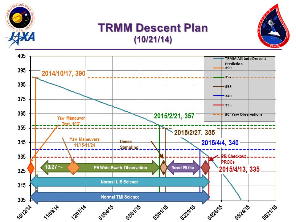
5 Tropical Rainfall Measuring Mission (TRMM) Completion of Precipitation Radar (PR) onboard the TRMM satellite on 7 th October Major characteristics Focused on rainfall observation. First instantaneous rainfall observation by three different sensors (PR, TMI, VIRS). PR, active sensor, can observe 3D structure of rainfall. Targeting tropical and subtropical region, and chose non-sun-synchronous orbit (inc. angle 35 degree) to observe diurnal variation. Major achievement in Japan Demonstration of high quality and high reliability of a satellite onboard precipitation radar Improvement of precipitation retrieval from passive microwave radiometer by PR 3D observation Pioneering precipitation system climatology by PR observation Launch 28 Nov (JST) Altitude About 350km (since 2001, boosted to 402km to extend mission operation Inc. angle Design life Instruments US-Japan joint mission Japan: PR, launch US: satellite, TMI, VIRS, CERES, LIS, operation About 35 degree, non-sunsynchronous orbit 3-year and 2month (still operating) Precipitation Radar (PR) TRMM Microwave Imager (TMI) Visible Infrared Scanner (VIRS) Lightning Imaging Sensor (LIS) CERES (not in operation)


6 TRMM PR 17-year averaged rainfall
7 7
 and GPM-Core(DPR) Dec. 1997-Oct.")

8 Spaceborne Precipitation Radar Development TRMM/PR (by JAXA/NICT) Ku-band 13.8GHz) GPM/DPR (by JAXA/NICT) Ku-band 13.6GHz Ka-band 35.5GHz 1-day orbits of TRMM(PR) and GPM-Core(DPR) Dec Oct.2014 World first spaceborne precipitation radar Significant improvement of the global rain estimation Deeper understanding on the tropical precipitation systems DPR first light: An extratropical cyclone seen off the coast of Japan, March 10, 2014 Feb Now Upgrade the TRMM/PR: Improvement of accuracy by the dual frequency radar Apply to higher latitude Apply to flood warning systems using Combined product of radar, MWR and IR long term global precipitation record 8
 GPM Core Observatory GMI (Microwave Imager)")
 Constellation Satellites by international")


.")
9 Global Precipitation Measurement (GPM) KaPR: 35.5GHz radar (phased array) GPM Core Observatory GMI (Microwave Imager) KuPR: 13.6GHz radar (phased array) Constellation Satellites by international partners GPM is an international mission consisting of the GPM Core Observatory and Constellation Satellites for high accurate and frequent global precipitation observation. Core Observatory: developed under NASA and JAXA equal partnership. Constellation satellites: provided by international partners (includes GCOM-W1). Dual-frequency Precipitation Radar (DPR) developed by JAXA and NICT DPR is composed of two radars: KuPR & KaPR GPM Core Observatory was successfully launched on 28 Feb (JST). Core Observatory by NASA-JAXA


10 JAXA s Role within GPM Project Since 2012 Development of DPR with NICT Launch of GPM Core Observatory by H-IIA rocket GCOM-W1 as one of constellation satellites Development of algorithms, GV, and GPM data processing and data distribution system to provide to end users Promotion of GPM data utilization and application in Japan and Asia 10


11 GPM Core Observatory Launch: 3:36 am on 28 Feb (JST) CG image NASA JAXA Launch from the JAXA Tanegashima Space Center by the H-IIA F23 rocket JAXA Separation of the spacecraft


12 NASA-JAXA Joint First Images from the GPM Core Observatory JAXA/NASA Three dimensional structure of precipitation captured by DPR on 10 Mar NASA/JAXA Extratropical Cyclone over the northwest Pacific Ocean (around 40N, 167E) around 1330Z on 10 Mar GMI 36-GHz H TB is overlaying to the Geostationary IR provided by JMA and NOAA. NASA-JAXA Joint First Images from the GPM Core Observatory was released on 25 th Mar Surface precipitation captured by GMI. NASA/JAXA 12
 Processed and distributed in near real time basis (about 4-hour after observations) by merging multi-satellite data. Hourly product in 0.1x0.1deg.")
13 Global Satellite Mapping of Precipitation (GSMaP) Developed in Japan toward the GPM mission. About 1000 registered users (Sep 2014 statistics) Processed and distributed in near real time basis (about 4-hour after observations) by merging multi-satellite data. Hourly product in 0.1x0.1deg. lat/lon grid. Proto-type version has been in operation in JAXA since GPM-GSMaP data were released on Sep GPM-GSMaP data is now available from JAXA G-portal ( as well as current GSMaP web site ( GSMaP/).
14 A movie of GPM-GSMaP in early June 2014 (Rainy season in Japan)


15 IPWG Validation collaboration The GSMaP joins the International Precipitation Working Group (IPWG) validation activities. We validates various satellite estimates around Japan. Our GSMaP products are validated in U.S.(J.-J.Wang/J. Janowiak), Australia (E. Ebert ), South America (D. Vila), Europe (C. Kidd), South Africa (E. Becker) and Japan (S. Shige).

16 JAXA Globe Portal (G-Portal)
APPENDIX 2 OVERVIEW OF THE GLOBAL PRECIPITATION MEASUREMENT (GPM) AND THE TROPICAL RAINFALL MEASURING MISSION (TRMM) 2-1
 AND THE TROPICAL RAINFALL MEASURING MISSION (TRMM) 2-1") APPENDIX 2 OVERVIEW OF THE GLOBAL PRECIPITATION MEASUREMENT (GPM) AND THE TROPICAL RAINFALL MEASURING MISSION (TRMM) 2-1 1. Introduction Precipitation is one of most important environmental parameters.
APPENDIX 2 OVERVIEW OF THE GLOBAL PRECIPITATION MEASUREMENT (GPM) AND THE TROPICAL RAINFALL MEASURING MISSION (TRMM) 2-1 1. Introduction Precipitation is one of most important environmental parameters.
GPM-GSMaP data is now available from JAXA G-portal (https://www.gportal.jaxa.jp) as well as current GSMaP web site (http://sharaku.eorc.jaxa.
 as well as current GSMaP web site (http://sharaku.eorc.jaxa.") GPM-GSMaP data is now available from JAXA G-portal (https://www.gportal.jaxa.jp) as well as current GSMaP web site (http://sharaku.eorc.jaxa.jp/ GSMaP/). GPM Core GMI TRMM PR GPM era Precipitation Radar
GPM-GSMaP data is now available from JAXA G-portal (https://www.gportal.jaxa.jp) as well as current GSMaP web site (http://sharaku.eorc.jaxa.jp/ GSMaP/). GPM Core GMI TRMM PR GPM era Precipitation Radar
Rainfall Observation from Space: A overview of GPM and GSMaP
 Rainfall Observation from Space: A overview of GPM and GSMaP (July 2016 version) Earth Observation Research Center (EORC) Japan Aerospace Exploration Agency (JAXA) Rainfall Measurement and our life Rain
Related missions and programs for Snowfall and Snow Hydrology of JAXA
 Related missions and programs for Snowfall and Snow Hydrology of JAXA ALOS AVNIR-2 2006/11/05 Shuji Shimizu Japan Aerospace Exploration Agency (JAXA) Earth Observation Research Center (EORC) JAXA Earth
JAXA s Contributions to the Climate Change Monitoring
 0 JAXA s Contributions to the Climate Change Monitoring June 7, 2011 Takao Akutsu Planning Manager Japan Aerospace Exploration Agency (JAXA) Japanese Main Activities of Earth Observation 1 GEOSS 10 years
JAXA Remote Sensing Satellite Missions Utilization for Earth and Environment Observation
 JAXA Remote Sensing Satellite Missions Utilization for Earth and Environment Observation 27 th June 2013 Toshiyoshi Kimura EORC/JAXA Inventory, Modeling and Climate Impacts of Greenhouse Gas emissions
Japanese Programs on Space and Water Applications
 Japanese Programs on Space and Water Applications Tamotsu IGARASHI Remote Sensing Technology Center of Japan June 2006 COPUOS 2006 Vienna International Centre Water-related hazards/disasters may occur
JAXA Earth Observation Satellites and the Validation
 JAXA Earth Observation Satellites and the Validation Keiji Imaoka + many colleagues Earth Observation Research Center (EORC) Japan Aerospace Exploration Agency (JAXA) March 9, 2012 4 th GRUAN ICM Meeting
CEOS Overview and JAXA Plans for Water Cycle Observation
 CEOS Overview and JAXA Plans for Water Cycle Observation Asian Water Cycle Symposium November 2-4, 2005 Tokyo, Japan Chu Ishida Japan Aerospace Exploration Agency (JAXA) Contents 1. CEOS overview 2. CEOS
Keiji Imaoka + many contributors. Earth Observation Research Center (EORC) Japan Aerospace Exploration Agency (JAXA)
 Japan Aerospace Exploration Agency (JAXA)") Keiji Imaoka + many contributors Earth Observation Research Center (EORC) Japan Aerospace Exploration Agency (JAXA) Mini-Workshop on A-Train Science Tokyo, Japan March 8, 2013 2 Late 1990s 2000s 2003 (JAXA
Keiji Imaoka + many contributors Earth Observation Research Center (EORC) Japan Aerospace Exploration Agency (JAXA) Mini-Workshop on A-Train Science Tokyo, Japan March 8, 2013 2 Late 1990s 2000s 2003 (JAXA
Global Flood Alert System based on satellite derived rainfall data -Targeting the era of Global Precipitation Measurement (GPM)-
-") Global Flood Alert System based on satellite derived rainfall data -Targeting the era of Global Precipitation Measurement (GPM)- Riko Oki, Misako Kachi (JAXA/EORC) Kazuhiko Fukami (PWRI) and Kazuo Umeda
Global Flood Alert System based on satellite derived rainfall data -Targeting the era of Global Precipitation Measurement (GPM)- Riko Oki, Misako Kachi (JAXA/EORC) Kazuhiko Fukami (PWRI) and Kazuo Umeda
Contribution to global Earth observation from satellites
 Contribution to global Earth observation from satellites - JAXA s Earth Observation strategy - April 16, 2008 Makoto Kajii Japan Aerospace Exploration Agency Earth Observation Summits and GEOSS 1 st EO
JAXA S FUTURE EARTH OBSERVATION MISSIONS FOR METEOROLOGICAL AND CLIMATOLOGICAL APPLICATIONS
 JAXA S FUTURE EARTH OBSERVATION MISSIONS FOR METEOROLOGICAL AND CLIMATOLOGICAL APPLICATIONS Misako Kachi, Keiji Imaoka, Hiroshi Murakami, Masahiro Hori, Shuichiro Katagiri, Shuji Shimizu, Riko Oki, and
Teruyuki Nakajima Director, Earth Observation Research Center (EORC) Japan Aerospace Exploration Agency (JAXA)
 Japan Aerospace Exploration Agency (JAXA)") Tokyo Inter. Conference on the Forest Governance Initiative - Improving Forest Governance using Forest Early Warning Systems and Satellite Technologies - October 24-26, 2017 Teruyuki Nakajima Director,
Tokyo Inter. Conference on the Forest Governance Initiative - Improving Forest Governance using Forest Early Warning Systems and Satellite Technologies - October 24-26, 2017 Teruyuki Nakajima Director,
Agency Status Reports: JMA and JAXA
 Agency Status Reports: JMA and JAXA Kozo Okamoto (JMA : Japan Meteorological Agency) Misako Kachi, Tamotsu Igarashi (JAXA : Japan Aerospace Exploration Agency) JMA Status and plan of MTSAT (Himawari-6
Global Precipitation Measurement (GPM) for Science and Society
 for Science and Society") Global Precipitation Measurement (GPM) for Science and Society Gail Skofronick-Jackson GPM Project Scientist NASA Goddard Space Flight Center Radar Observation of Rain from Space Tokyo, Japan 29 November
Global Precipitation Measurement (GPM) for Science and Society Gail Skofronick-Jackson GPM Project Scientist NASA Goddard Space Flight Center Radar Observation of Rain from Space Tokyo, Japan 29 November
Development of Spaceborne Dualfrequency. and Its Role for the Global Precipitation Measurement
 Development of Spaceborne Dualfrequency Precipitation Radar and Its Role for the Global Precipitation Measurement Shinsuke Satoh (1), Riko Oki (1), Nobuhiro Takahashi (2), and Toshio Iguchi (2) (1) National
"Cloud and Rainfall Observations using Microwave Radiometer Data and A-priori Constraints" Christian Kummerow and Fang Wang Colorado State University
 "Cloud and Rainfall Observations using Microwave Radiometer Data and A-priori Constraints" Christian Kummerow and Fang Wang Colorado State University ECMWF-JCSDA Workshop Reading, England June 16-18, 2010
JAXA s satellites for Disaster Risk Reduction
 JAXA s satellites for Disaster Risk Reduction October 9, 2017 Masanobu TSUJI Japan Aerospace Exploration Agency (JAXA) Panel on Space Technology and Applications in Support of theregional Roadmap for Implementing
OVERVIEW OF THE FIRST SATELLITE OF THE GLOBAL CHANGE OBSERVATION MISSION - WATER (GCOM-W1)
") OVERVIEW OF THE FIRST SATELLITE OF THE GLOBAL CHANGE OBSERVATION MISSION - WATER (GCOM-W1) Misako Kachi, Keiji Imaoka, Hideyuki Fujii, Daisaku Uesawa, Kazuhiro Naoki, Akira Shibata, Tamotsu Igarashi, Earth
OVERVIEW OF THE FIRST SATELLITE OF THE GLOBAL CHANGE OBSERVATION MISSION - WATER (GCOM-W1) Misako Kachi, Keiji Imaoka, Hideyuki Fujii, Daisaku Uesawa, Kazuhiro Naoki, Akira Shibata, Tamotsu Igarashi, Earth
Overview and Access to GPCP, TRMM, and GPM Precipitation Data Products
 National Aeronautics and Space Administration ARSET Applied Remote Sensing Training http://arset.gsfc.nasa.gov @NASAARSET Overview and Access to GPCP, TRMM, and GPM Precipitation Data Products www.nasa.gov
Synergistic Use of Spaceborne Active Sensors and Passive Multispectral Imagers for Investigating Cloud Evolution Processes
 Trans. JSASS Aerospace Tech. Japan Vol. 12, No. ists29, pp. Tn_19-Tn_24, 2014 Topics Synergistic Use of Spaceborne Active Sensors and Passive Multispectral Imagers for Investigating Cloud Evolution Processes
TRMM, Hydrologic Science, and Societal Benefit: The Role of Satellite Measurements
 TRMM, Hydrologic Science, and Societal Benefit: The Role of Satellite Measurements Michael H. Freilich TRMM 15 th Anniversary Symposium 12 November 2012 KEY TRMM ATTRIBUTES Long on-orbit lifetime 15 years
GCOM-W1 now on the A-Train
 GCOM-W1 now on the A-Train GCOM-W1 Global Change Observation Mission-Water Taikan Oki, K. Imaoka, and M. Kachi JAXA/EORC (& IIS/The University of Tokyo) Mini-Workshop on A-Train Science, March 8 th, 2013
GSMaP - Integrated application with developer and user collaboration -
 WIGOS WORKSHOP 2019 Session 2.2 GSMaP - Integrated application with developer and user collaboration - Takuji Kubota and Moeka Yamaji Earth Observation Research Center (EORC) Japan Aerospace Exploration
Global Precipitation Measurement Mission Overview & NASA Status
 Global Precipitation Measurement Mission Overview & NASA Status Gail Skofronick Jackson GPM Project Scientist (appointed 14 January 2014) Replacing Dr. Arthur Hou (1947-2013) NASA Goddard Space Flight
Keiji Imaoka Earth Observation Research Center (EORC) Japan Aerospace Exploration Agency (JAXA) GSICS/GRWG Meeting Darmstadt, Germany March 25, 2014
 Japan Aerospace Exploration Agency (JAXA) GSICS/GRWG Meeting Darmstadt, Germany March 25, 2014") Keiji Imaoka Earth Observation Research Center (EORC) Japan Aerospace Exploration Agency (JAXA) GSICS/GRWG Meeting Darmstadt, Germany March 25, 2014 JAXA Satellite Projects Late 1990s 2000s 2003 (JAXA
Keiji Imaoka Earth Observation Research Center (EORC) Japan Aerospace Exploration Agency (JAXA) GSICS/GRWG Meeting Darmstadt, Germany March 25, 2014 JAXA Satellite Projects Late 1990s 2000s 2003 (JAXA
JAXA agency report. Masumi MATSUNAGA Satellite Applications and Operations Center(SAOC), JAXA
, JAXA") JAXA agency report Masumi MATSUNAGA Satellite Applications and Operations Center(SAOC), JAXA JAXA Activities Space Transportation Human Space Activities Satellite Programs Lunar & Planetary Exploration
JAXA agency report Masumi MATSUNAGA Satellite Applications and Operations Center(SAOC), JAXA JAXA Activities Space Transportation Human Space Activities Satellite Programs Lunar & Planetary Exploration
Overview of Long- term Observa3ons of the Global Water Cycle by the Advanced Microwave Scanning Radiometer (AMSR) Series
 Series") Overview of Long- term Observa3ons of the Global Water Cycle by the Advanced Microwave Scanning Radiometer (AMSR) Series M. Kachi 1), T. Maeda 1), N. Ono 1), M. Kasahara 1), N. Ebuchi 1),2), and H. Shimoda
Overview of Long- term Observa3ons of the Global Water Cycle by the Advanced Microwave Scanning Radiometer (AMSR) Series M. Kachi 1), T. Maeda 1), N. Ono 1), M. Kasahara 1), N. Ebuchi 1),2), and H. Shimoda
Long-term Water Cycle Observation by the Advanced Microwave Scanning Radiometer (AMSR) Series: AMSR-E, AMSR2 and Follow-on
 Series: AMSR-E, AMSR2 and Follow-on") Long-term Water Cycle Observation by the Advanced Microwave Scanning Radiometer (AMSR) Series: AMSR-E, AMSR2 and Follow-on M. Kachi 1), H. Fujii 1), T. Kubota 1), T. Maeda 1), N. Ono 1), M. Kasahara 1),
Long-term Water Cycle Observation by the Advanced Microwave Scanning Radiometer (AMSR) Series: AMSR-E, AMSR2 and Follow-on M. Kachi 1), H. Fujii 1), T. Kubota 1), T. Maeda 1), N. Ono 1), M. Kasahara 1),
CLOUD AND PRECIPITATION OBSERVATION BY SPACEBORNE RADAR IN JAPAN: CURRENT AND FUTURE MISSIONS
 CLOUD AND PRECIPITATION OBSERVATION BY SPACEBORNE RADAR IN JAPAN: CURRENT AND FUTURE MISSIONS R. Oki a, T. Kubota a *, S. Katagiri a, M. Kachi a, S. Shimizu a, M. Kojima b, K. Kimura c a Earth Observation
The Global Precipitation Measurement (GPM) Mission: Arthur Hou. NASA Goddard Space Flight Center
 Mission: Arthur Hou. NASA Goddard Space Flight Center") The Global Precipitation Measurement (GPM) Mission: Overview and U.S. Status Arthur Hou NASA Goddard Space Flight Center 5 th IPWG Workshop 11-15 October 2010 GPM Mission Concept An international ti satellite
The Global Precipitation Measurement (GPM) Mission: Overview and U.S. Status Arthur Hou NASA Goddard Space Flight Center 5 th IPWG Workshop 11-15 October 2010 GPM Mission Concept An international ti satellite
Interpretation of Polar-orbiting Satellite Observations. Atmospheric Instrumentation
 Interpretation of Polar-orbiting Satellite Observations Outline Polar-Orbiting Observations: Review of Polar-Orbiting Satellite Systems Overview of Currently Active Satellites / Sensors Overview of Sensor
Outline of 4 Lectures
 Outline of 4 Lectures 1. Sept. 17, 2008: TC best track definition and datasets, global distribution of TCs; Review of history of meteorological satellites, introducing different orbits, scanning patterns,
JAXA s satellites for Disaster Management and Climate Change
 JAXA s satellites for Disaster Management and Climate Change August 24, 2017 Masanobu TSUJI Japan Aerospace Exploration Agency (JAXA) JAXA Activities Space Transportation Human Space Activities Satellite
Global Precipitation Data Sets
 Global Precipitation Data Sets Rick Lawford (with thanks to Phil Arkin, Scott Curtis, Kit Szeto, Ron Stewart, etc) April 30, 2009 Toronto Roles of global precipitation products in drought studies: 1.Understanding
P6.13 GLOBAL AND MONTHLY DIURNAL PRECIPITATION STATISTICS BASED ON PASSIVE MICROWAVE OBSERVATIONS FROM AMSU
 P6.13 GLOBAL AND MONTHLY DIURNAL PRECIPITATION STATISTICS BASED ON PASSIVE MICROWAVE OBSERVATIONS FROM AMSU Frederick W. Chen*, David H. Staelin, and Chinnawat Surussavadee Massachusetts Institute of Technology,
The use and impacts of sea surface temperature from passive microwave measurements
 The use and impacts of sea surface temperature from passive microwave measurements Anne O Carroll 6/12/2017 ECMWF workshop on using low frequency passive microwave measurements in research and operational
Value of Satellite Observation Sensitive to Humidity and Precipitation in JMA s Operational Numerical Weather Prediction
 地球観測衛星 30 周年記念シンポジウム JAXA Symposium for earth observing satellites 気象庁の現業数値気象予報における衛星観測データの水蒸気及び降水の解析予測精度への貢献 Value of Satellite Observation Sensitive to Humidity and Precipitation in JMA s Operational
Status of GCOM and expectation for microwave scatterometer
 Status of GCOM and expectation for microwave scatterometer Keiji Imaoka 1, Misako Kachi 1, Tamotsu Igarashi 1, Keizo Nakagawa 1, Naoto Ebuchi 2, Taikan Oki 1,3, and Haruhisa Shimoda 1,4 1 Japan Aerospace
Satellite Rainfall Retrieval Over Coastal Zones
 Satellite Rainfall Retrieval Over Coastal Zones Deltas in Times of Climate Change II Rotterdam. September 26, 2014 Efi Foufoula-Georgiou University of Minnesota 1 Department of Civil, Environmental and
Real-time Global Satellite Mapping of Precipitation (GSMaP) product
 product") Real-time Global Satellite Mapping of Precipitation (GSMaP) product Riko Oki Earth Observation Research Center (EORC) Japan Aerospace Exploration Agency (JAXA) JAXA s Current and Future Satellite/Sensor
Real-time Global Satellite Mapping of Precipitation (GSMaP) product Riko Oki Earth Observation Research Center (EORC) Japan Aerospace Exploration Agency (JAXA) JAXA s Current and Future Satellite/Sensor
APPENDIX 1 OVERVIEW OF THE GLOBAL CHANGE OBSERVATION MISSION (GCOM)
") APPENDIX 1 OVERVIEW OF THE GLOBAL CHANGE OBSERVATION MISSION (GCOM) 1-1 1. Introduction Comprehensive observation, understanding, assessment, and prediction of global climate change are common and important
APPENDIX 1 OVERVIEW OF THE GLOBAL CHANGE OBSERVATION MISSION (GCOM) 1-1 1. Introduction Comprehensive observation, understanding, assessment, and prediction of global climate change are common and important
New Concept of Regional Cooperation in Asia for Water Disaster Management Applying Satellite Precipitation Measurement
 New Concept of Regional Cooperation in Asia for Water Disaster Management Applying Satellite Precipitation Measurement Yusuke Muraki Japan Aerospace Exploration Agency (JAXA) Mission Planning Department
STATUS OF THE FIRST SATELLITE OF THE GLOBAL CHANGE OBSERVATION MISSION - WATER (GCOM-W1)
") STATUS OF THE FIRST SATELLITE OF THE GLOBAL CHANGE OBSERVATION MISSION - WATER (GCOM-W1) Misako Kachi 1, Keiji Imaoka 1, Masahiro Hori 1, Kazuhiro Naoki 1, Takashi Maeda 1, Arata Okuyama 1, Marehiro Kasahara
STATUS OF THE FIRST SATELLITE OF THE GLOBAL CHANGE OBSERVATION MISSION - WATER (GCOM-W1) Misako Kachi 1, Keiji Imaoka 1, Masahiro Hori 1, Kazuhiro Naoki 1, Takashi Maeda 1, Arata Okuyama 1, Marehiro Kasahara
GLOBAL PRECIPITATION MEASUREMENT UPDATE
 GLOBAL PRECIPITATION MEASUREMENT UPDATE Gilbert Mark Flaming National Aeronautics and Space Administration Goddard Space Flight Center Code 420.2 Greenbelt, Maryland 20771 USA Email: gilbert.m.flaming@nasa.gov
Remote sensing of precipitation extremes
 The panel is about: Understanding and predicting weather and climate extreme Remote sensing of precipitation extremes Climate extreme : (JSC meeting, June 30 2014) IPCC SREX report (2012): Climate Ali
Comparison of Diurnal Variation of Precipitation System Observed by TRMM PR, TMI and VIRS
 Comparison of Diurnal Variation of Precipitation System Observed by TRMM PR, TMI and VIRS Munehisa K. Yamamoto, Fumie A. Furuzawa 2,3 and Kenji Nakamura 3 : Graduate School of Environmental Studies, Nagoya
Analysis of TRMM Precipitation Radar Measurements over Iraq
 International Journal of Scientific and Research Publications, Volume 6, Issue 12, December 2016 1 Analysis of TRMM Precipitation Radar Measurements over Iraq Munya F. Al-Zuhairi, Kais J. AL-Jumaily, Ali
Eighteenth International Water Technology Conference, IWTC18 Sharm ElSheikh, March 2015
 SPATIOTEMPORAL EVALUATION OF GLOBAL PRECIPITATION MAPPING -GSMAP AT BASIN SCALE IN SAGAMI RIVER, JAPAN S. Takegawa 1, K. Takido 2, ando. Saavedra 3 1 Tokyo Institute of Technology, Tokyo,koizumi.s.ae@m.titech.ac.jp
Satellite-based applications for water resources management in Asia and Pacific region
 Satellite-based applications for water resources management in Asia and Pacific region Ko Hamamoto Japan Aerospace Exploration Agency The views expressed in this paper/presentation are the views of the
Radio Frequency Earth Science
 Radio Frequency Earth Science Overview for Committee On Radio Frequency (CORF) National Academy of Science National Research Council April 27, 2005 Bill.Watson@NASA.Gov Program Executive for Ground Networks
New NASA Ocean Observations and Coastal Applications
 New NASA Ocean Observations and Coastal Applications Duane Armstrong Chief, Applied Science & Technology Project Office August 20, 2014 1 Outline NASA s new Earth Science Ocean Science Missions for 2014
Passive and Active Microwave Sensors for Precipitation Research
 Passive and Active Microwave Sensors for Precipitation Research Joe Turk Jet Propulsion Laboratory California Institute of Technology Pasadena, CA jturk@jpl.nasa.gov Characteristics of Precipitation Wide
Current and Upcoming NASA Hurricane Measurement Missions National Hurricane Conference
 NASA Science Mission Directorate Earth Science Division Applied Sciences Program Current and Upcoming NASA Hurricane Measurement Missions National Hurricane Conference April 18, 2017 Formulation Implementation
Eight Years of TRMM Data: Understanding Regional Mechanisms Behind the Diurnal Cycle
 Eight Years of TRMM Data: Understanding Regional Mechanisms Behind the Diurnal Cycle Steve Nesbitt, Rob Cifelli, Steve Rutledge Colorado State University Chuntao Liu, Ed Zipser University of Utah Funding
Satellite Remote Sensing for Ocean
 Satellite Remote Sensing for Ocean August 17, 2017 Masatoshi Kamei RESTEC All rights reserved RESTEC 2015 Contents 1. About RESTEC and Remote Sensing 2. Example of Remote Sensing Technology 3. Remote Sensing
IPWG s Potential Role in a Snow Hydrology Mission
 IPWG s Potential Role in a Snow Hydrology Mission Chris Kidd The University of Birmingham Birmingham, United Kingdom International Precipitation Working Group Ralph Ferraro NOAA/NESDIS College Park, MD
H-SAF future developments on Convective Precipitation Retrieval
 H-SAF future developments on Convective Precipitation Retrieval Francesco Zauli 1, Daniele Biron 1, Davide Melfi 1, Antonio Vocino 1, Massimiliano Sist 2, Michele De Rosa 2, Matteo Picchiani 2, De Leonibus
URSI-F Microwave Signatures Meeting 2010, Florence, Italy, October 4 8, Thomas Meissner Lucrezia Ricciardulli Frank Wentz
 URSI-F Microwave Signatures Meeting 2010, Florence, Italy, October 4 8, 2010 Wind Measurements from Active and Passive Microwave Sensors High Winds and Winds in Rain Thomas Meissner Lucrezia Ricciardulli
Ⅴ.. Global Flood Alert System
 Ⅴ.. Global Flood Alert System 1. Project Concept - An attempt to make the best use of Satellite Rainfall in FEW - Support for existing FEW activities where necessary 2. Collaboration between: i) Space
CHAPTER VII COMPARISON OF SATELLITE (TRMM) PRECIPITATION DATA WITH GROUND-BASED DATA
 PRECIPITATION DATA WITH GROUND-BASED DATA") CHAPTER VII COMPARISON OF SATELLITE () PRECIPITATION DATA WITH GROUND-BASED DATA CHAPTER VII COMPARISON OF SATELLITE () PRECIPITATION DATA WITH GROUND-BASED DATA 7.1. INTRODUCTION Most of the earth s rain
CHAPTER VII COMPARISON OF SATELLITE () PRECIPITATION DATA WITH GROUND-BASED DATA CHAPTER VII COMPARISON OF SATELLITE () PRECIPITATION DATA WITH GROUND-BASED DATA 7.1. INTRODUCTION Most of the earth s rain
School on Modelling Tools and Capacity Building in Climate and Public Health April Rainfall Estimation
 2453-6 School on Modelling Tools and Capacity Building in Climate and Public Health 15-26 April 2013 Rainfall Estimation CECCATO Pietro International Research Institute for Climate and Society, IRI The
P4.4 THE COMBINATION OF A PASSIVE MICROWAVE BASED SATELLITE RAINFALL ESTIMATION ALGORITHM WITH AN IR BASED ALGORITHM
 P4.4 THE COMBINATION OF A PASSIVE MICROWAVE BASED SATELLITE RAINFALL ESTIMATION ALGORITHM WITH AN IR BASED ALGORITHM Robert Joyce 1), John E. Janowiak 2), and Phillip A. Arkin 3, Pingping Xie 2) 1) RS
JAXA s Ocean Environment Monitoring Activities and Himawari Monitor
 JAXA s Ocean Environment Monitoring Activities and Himawari Monitor Misako Kachi, Yukio Kurihara, Hiroshi Murakami, Norimasa Ito (JAXA) Yasumasa Miyazawa (JAMSTEC) IOVWST@Sapporo, 17-19 May, 2016 Research
Satellite derived precipitation estimates over Indian region during southwest monsoons
 J. Ind. Geophys. Union ( January 2013 ) Vol.17, No.1, pp. 65-74 Satellite derived precipitation estimates over Indian region during southwest monsoons Harvir Singh 1,* and O.P. Singh 2 1 National Centre
The Status of NOAA/NESDIS Precipitation Algorithms and Products
 The Status of NOAA/NESDIS Precipitation Algorithms and Products Ralph Ferraro NOAA/NESDIS College Park, MD USA S. Boukabara, E. Ebert, K. Gopalan, J. Janowiak, S. Kidder, R. Kuligowski, H. Meng, M. Sapiano,
Impact of Intraseasonal Variations to the Spatial Distribution of Coastal Heavy Rainbands Intensity During HARIMAU IOP 2011 in the West Sumatera
 Impact of Intraseasonal Variations to the Spatial Distribution of Coastal Heavy Rainbands Intensity During HARIMAU IOP 2011 in the West Sumatera Ardhi Adhary Arbain, Yekti Galihselowati Agency for the
Intercomparison of Satellite Precipitation Products for Different Cloud Types
 8 th IPWG & 5 th IWSSM Joint Workshop Bologna, 3-7 October, 2016 Intercomparison of Satellite Precipitation Products for Different Cloud Types Nobuyuki UTSUMI Hyungjun Kim, Taikan OKI (IIS, The University
Remote Sensing in Meteorology: Satellites and Radar. AT 351 Lab 10 April 2, Remote Sensing
 Remote Sensing in Meteorology: Satellites and Radar AT 351 Lab 10 April 2, 2008 Remote Sensing Remote sensing is gathering information about something without being in physical contact with it typically
Assimilation of precipitation-related observations into global NWP models
 Assimilation of precipitation-related observations into global NWP models Alan Geer, Katrin Lonitz, Philippe Lopez, Fabrizio Baordo, Niels Bormann, Peter Lean, Stephen English Slide 1 H-SAF workshop 4
Validation experiments of GPM/DPR on the pure oceanic precipitating clouds by instruments on board R/V Mirai
 Validation experiments of GPM/DPR on the pure oceanic precipitating clouds by instruments on board R/V Mirai PI: Masaki KATSUMATA (JAMSTEC) CI: Katsuhiro NAKAGAWA (NICT) Jun INOUE (NIPR / JAMSTEC) Takashi
GLOBAL SATELLITE MAPPING OF PRECIPITATION (GSMAP) PROJECT
 PROJECT") GLOBAL SATELLITE MAPPING OF PRECIPITATION (GSMAP) PROJECT Tomoo Ushio 1, Kazumasa Aonashi 2, Takuji Kubota 3, Shoichi Shige 4, Misako Kachi 3, Riko Oki 3, Ken ichi Okamoto 5, Satoru Yoshida 1, Zen-Ichiro
GLOBAL SATELLITE MAPPING OF PRECIPITATION (GSMAP) PROJECT Tomoo Ushio 1, Kazumasa Aonashi 2, Takuji Kubota 3, Shoichi Shige 4, Misako Kachi 3, Riko Oki 3, Ken ichi Okamoto 5, Satoru Yoshida 1, Zen-Ichiro
for the Global Precipitation Mission
 A Physically based Rainfall Rate Algorithm for the Global Precipitation Mission Kevin Garrett 1, Leslie Moy 1, Flavio Iturbide Sanchez 1, and Sid Ahmed Boukabara 2 5 th IPWG Workshop Hamburg, Germany October
Rainfall estimation over the Taiwan Island from TRMM/TMI data
 P1.19 Rainfall estimation over the Taiwan Island from TRMM/TMI data Wann-Jin Chen 1, Ming-Da Tsai 1, Gin-Rong Liu 2, Jen-Chi Hu 1 and Mau-Hsing Chang 1 1 Dept. of Applied Physics, Chung Cheng Institute
11D.6 DIURNAL CYCLE OF TROPICAL DEEP CONVECTION AND ANVIL CLOUDS: GLOBAL DISTRIBUTION USING 6 YEARS OF TRMM RADAR AND IR DATA
 11D.6 DIURNAL CYCLE OF TROPICAL DEEP CONVECTION AND ANVIL CLOUDS: GLOBAL DISTRIBUTION USING 6 YEARS OF TRMM RADAR AND IR DATA 1. INTRODUCTION Before the launch of the TRMM satellite in late 1997, most
Global Rainfall Map Realtime version (GSMaP_NOW) Data Format Description
 Data Format Description") updated 01 November 2018 2 November 2015 Global Rainfall Map Realtime version (GSMaP_NOW) Data Format Description This document describes data format and information of Global Rainfall Map Realtime version
updated 01 November 2018 2 November 2015 Global Rainfall Map Realtime version (GSMaP_NOW) Data Format Description This document describes data format and information of Global Rainfall Map Realtime version
NASA Flood Monitoring and Mapping Tools
 National Aeronautics and Space Administration ARSET Applied Remote Sensing Training http://arset.gsfc.nasa.gov @NASAARSET NASA Flood Monitoring and Mapping Tools www.nasa.gov Outline Overview of Flood
Analyzing and Visualizing Precipitation and Soil Moisture in ArcGIS
 Analyzing and Visualizing Precipitation and Soil Moisture in ArcGIS Wenli Yang, Pham Long, Peisheng Zhao, Steve Kempler, and Jennifer Wei * NASA Goddard Earth Science Data and Information Services Center
Status reports: JMA and JAXA
 Status reports: JMA and JAXA K. Okamoto 1, N. Uekiyo 1 M. Kachi 2, T. Kimura 2 1 : Japan Meteorological Agency (JMA) 2 : Japan Aerospace Exploration Agency (JAXA) ITSC16, Angra dos Reis, Brazil, 7-13 May
CEOS SST-VC. Passive Microwave Radiometer Constellation for Sea Surface Temperature
 CEOS SST-VC Passive Microwave Radiometer Constellation for Sea Surface Temperature Page 1 of 9 Date 20 th April 2016 Ref. CEOS-SST-VC-PMW-constellation.doc Prepared by A. O Carroll (EUMETSAT) and K. Casey
GLM INR and Instrument Performance Evaluation
 GLM INR and Instrument Performance Evaluation Presented by Dennis Buechler University of Alabama in Huntsville Joint MTG LI Mission Advisory Group & GOES-R GLM Science Team Workshop, Rome Italy 27-29 May
Joint Polar Satellite System. 3 rd Post-EPS User Consultation Workshop Mike Haas
 3 rd Post-EPS User Consultation Workshop Mike Haas Overview Introduction - Policy Drivers - Management System Description - Space Segment - Ground Segment Partnerships Status Benefits 2 Introduction (Policy
Monitoring Air Pollution from Space
 Monitoring Air Pollution from Space Media Regional Training Workshop 16 th Nov 20 th Nov 2015 Shreta Ghimire International Centre for Integrated Mountain Development Kathmandu, Nepal Why do we study air
Characteristics of Precipitation Systems over Iraq Observed by TRMM Radar
 American Journal of Engineering Research (AJER) e-issn: 2320-0847 p-issn : 2320-0936 Volume-5, Issue-11, pp-76-81 www.ajer.org Research Paper Open Access Characteristics of Precipitation Systems over Iraq
GPS Meteorology at Japan Meteorological Agency
 GPS Meteorology at Japan Meteorological Agency Masahito Ishihara Japan Meteorological Agency CIMO Expert Team on Remote Sensing Upper-Air Technology and Techniques 14-17 March, 2005 Geneva, Switzerland
Daniel J. Cecil 1 Mariana O. Felix 1 Clay B. Blankenship 2. University of Alabama - Huntsville. University Space Research Alliance
 12A.4 SEVERE STORM ENVIRONMENTS ON DIFFERENT CONTINENTS Daniel J. Cecil 1 Mariana O. Felix 1 Clay B. Blankenship 2 1 University of Alabama - Huntsville 2 University Space Research Alliance 1. INTRODUCTION
P3.4 POSSIBLE IMPROVEMENTS IN THE STANDARD ALGORITHMS FOR TRMM/PR
 P3.4 POSSIBLE IMPROVEMENTS IN THE STANDARD ALGORITHMS FOR TRMM/PR Nobuhiro Takahashi* and Toshio Iguchi National Institute of Information and Communications Technology 1. INTRODUCTION The latest version
Evaluation of Satellite Precipitation Products over the Central of Vietnam
 Evaluation of Satellite Precipitation Products over the Central of Vietnam Long Trinh-Tuan (1), Jun Matsumoto (1,2), Thanh Ngo-Duc (3) (1) Department of Geography, Tokyo Metropolitan University, Japan.
4.1 New Generation Satellite Data and Nowcasting Products: Himawari
 4.1 New Generation Satellite Data and Nowcasting Products: Himawari SCOPE-Nowcasting-EP 18-20 September 2017 Koji Yamashita kobo.yamashita@met.kishou.go.jp Meteorological Satellite Center (MSC) Japan Meteorological
Trial Running of GFAS
 Trial Running of GFAS International Flood Network Please access to: http://www.internationalfloodnetwork.org/index.html What is GFAS? Global Flood Alert System (GFAS) provides with global rainfall information
School on Modelling Tools and Capacity Building in Climate and Public Health April Remote Sensing
 2453-5 School on Modelling Tools and Capacity Building in Climate and Public Health 15-26 April 2013 Remote Sensing CECCATO Pietro International Research Institute for Climate and Society, IRI The Earth
NOAA/NESDIS Tropical Web Page with LEO Satellite Products and Applications for Forecasters
 NOAA/NESDIS Tropical Web Page with LEO Satellite Products and Applications for Forecasters Sheldon Kusselson National Oceanic and Atmospheric Administration (NOAA) National Environmental Satellite Data
Satellite-Based Rainfall Estimates and Their Application in Global Flood and Landslide Calculations
 Satellite-Based Rainfall Estimates and Their Application in Global Flood and Landslide Calculations Robert Adler (U. of Maryland-College Park) Huan Wu (UMD), Dalia Bach (UMD), Yang Hong (U. of OK), Hal
Megha-Tropiques Presentation by Indian Delegation at the 55th Session of UNCOPUOS Vienna 12 June 2012
 Megha-Tropiques Presentation by Indian Delegation at the 55 th Session of UNCOPUOS Vienna 12 June 2012 Megha-Tropiques Mission Indo-French Joint Satellite for studying tropical atmosphere Megha in Sanskrit
SMAP and SMOS Integrated Soil Moisture Validation. T. J. Jackson USDA ARS
 SMAP and SMOS Integrated Soil Moisture Validation T. J. Jackson USDA ARS Perspective Linkage of SMOS and SMAP soil moisture calibration and validation will have short and long term benefits for both missions.
Significant cyclone activity occurs in the Mediterranean
 TRMM and Lightning Observations of a Low-Pressure System over the Eastern Mediterranean BY K. LAGOUVARDOS AND V. KOTRONI Significant cyclone activity occurs in the Mediterranean area, mainly during the
GSMaP RIKEN Nowcast (GSMaP_RNC) Data Format Description
 Data Format Description") GSMaP RIKEN Nowcast (GSMaP_RNC) Data Format Description 4 August 2017 This document describes data format and information of Global Satellite Mapping of Precipitation (GSMaP) RIKEN Nowcast provided by
GSMaP RIKEN Nowcast (GSMaP_RNC) Data Format Description 4 August 2017 This document describes data format and information of Global Satellite Mapping of Precipitation (GSMaP) RIKEN Nowcast provided by
ALOS-2 Project Manager. Shin-ichi Sobue
 ALOS-2 Project Manager Shin-ichi Sobue JAXA Earth Observation Satellites Targets (JFY) 2014 2015 2016 2017 2018 2019 2020 2021 2022 2023 2024 [Land and disaster monitoring] Disasters & Resources Climate
GEOSC/METEO 597K Kevin Bowley Kaitlin Walsh
 GEOSC/METEO 597K Kevin Bowley Kaitlin Walsh Timeline of Satellites ERS-1 (1991-2000) NSCAT (1996) Envisat (2002) RADARSAT (2007) Seasat (1978) TOPEX/Poseidon (1992-2005) QuikSCAT (1999) Jason-2 (2008)