Recent Developments of JMA Operational NWP Systems and WGNE Intercomparison of Tropical Cyclone Track Forecast
|
|
|
- Priscilla Blair
- 5 years ago
- Views:
Transcription

1 Recent Developments of JMA Operational NWP Systems and WGNE Intercomparison of Tropical Cyclone Track Forecast Chiashi Muroi Numerical Prediction Division Japan Meteorological Agency 1

2 CURRENT STATUS AND RECENT DEVELOPMENTS OF JMA NWP SYSTEM 2


3 Numerical Weather Prediction Meteorology Mechanism, Observation Weather forecast Fluid dynamic Governing equation s Computational science Mathematics, Numerical method, Computer Numerical Model Climate Prediction Supercomputer 3

4 History of NWP at JMA 4
 Japan and its surroundings (3160km x 2600km)")
 264 hours (12 UTC) Global Analysis (4D-Var) 50 21.8km 39 hours (00, 03, 06, 09, 12, 15, 18, 21 UTC) Meso-scale Analysis (4D-Var) 60 20.")
5 Current NWP models of NPD/JMA Global Spectral Model GSM Meso-Scale Model MSM Local Forecast Model LFM One-week Ensemble WEPS Typhoon Ensemble TEPS Objectives Short- and Mediumrange forecast Disaster reduction Aviation forecast Aviation forecast Disaster reduction One-week forecast Typhoon forecast Global Japan and its surroundings (4080km x 3300km) Japan and its surroundings (3160km x 2600km) Global Forecast domain Horizontal resolution Vertical levels / Top Forecast Hours (Initial time) Initial Condition T L 959( deg) 5km 2km T L 319( deg) hpa 84 hours (00, 06, 18 UTC) 264 hours (12 UTC) Global Analysis (4D-Var) km 39 hours (00, 03, 06, 09, 12, 15, 18, 21 UTC) Meso-scale Analysis (4D-Var) km 9 hours (00-23 UTC hourly) Local Analysis (3D-Var) 264 hours (12 UTC) 51 members hpa 132 hours (00, 06, 12, 18 UTC) 11 members Global Analysis with ensemble perturbations (SV)
6 RMSE of geopotential height (m) Smaller error Verification score of global model 80 GSM Z500(20N-90N) RMSE 00UTC/12UTC 1-day forecast 2-day forecast 3-hour forecast 24h_Fcst 48h_Fcst 72h_Fcst Ave(24h) Ave(48h) Ave(72h) _12L- 1985_12L- 1986_12L- 1987_12L- 1988_16L- 1989_16L- 1990_21L- 1991_21L- 1992_21L- 1993_21L- 1994_21L- 1995_21L- 1996_30L- 1997_30L- 1998_30L- RMSE of 500 hpa geopotential height in Northern Hemisphere (20-90N) The accuracy of 3-day forecast in 2013 compares with that of 1-day forecast in 1980 s. 1999_30L- 2000_30L- 2001_40L- 2002_40L- 2003_40L- 2004_40L- 2005_40L- 2006_40L- 2007_40L- 2008_60L- 2009_60L L L L- 7
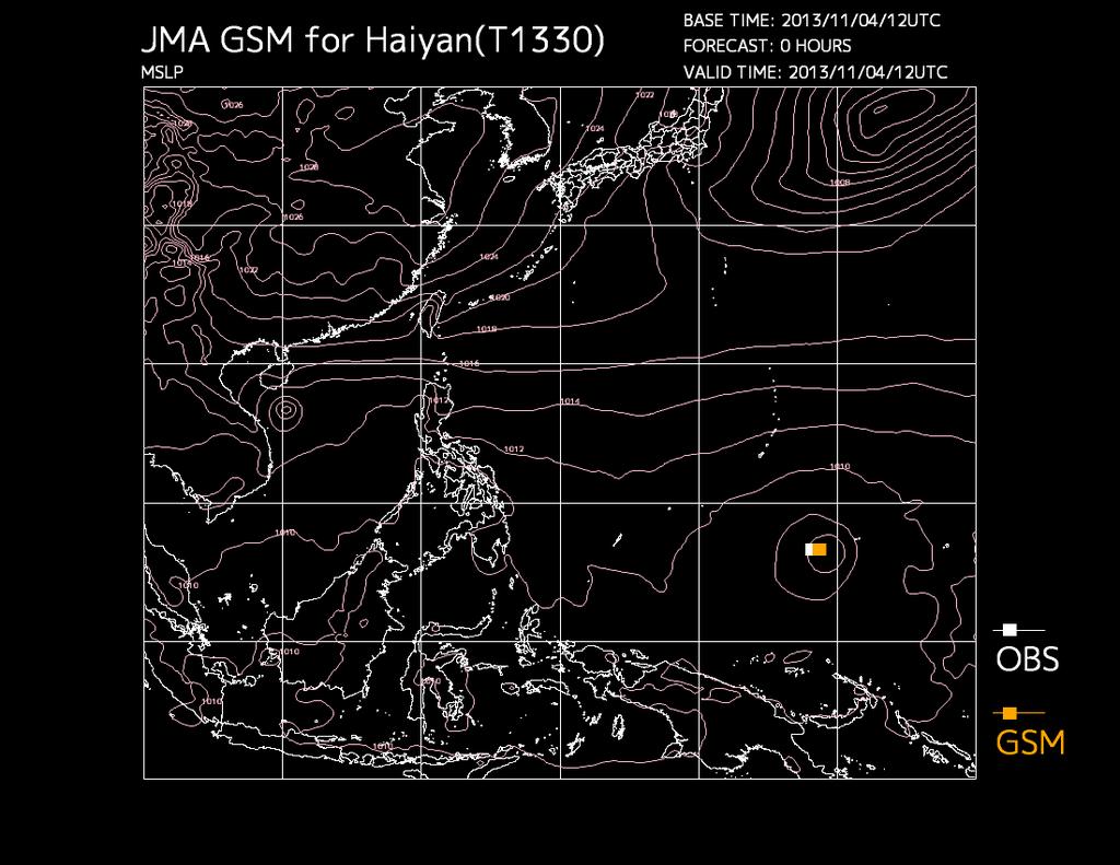
7 Example of Typhoon Forecast by 20km-GSM Accuracy of current NWP is generally good. GSM predicted typhoons track well Obs. 8
8 9
9 Recent improvements of Global data assimilation system Enhancement of utilized atmospheric motion vectors (AMVs) (July 2013) AMV data coverage. The red rectangles indicate areas covered by LEOGEO AMVs. Introduction of AMSR2 onboard GCOM-W1 (Japanese name: Shizuku) (September 2013) MW imager data coverage.gcom-w1/amsr2 data fill the gaps. Note: DMSP-F16 and F17 had almost the same coverage as of summer Introduction of data from Metop-B Mean TC position errors (in km) as a function of forecast time up to 84 hours in summer The red and blue lines indicate errors of forecasts with and without Metop-B data, respectively. The dots correspond to the vertical axis on the right, which represents the number of verification samples. with Metop-B w/o Metop-B DMSP-F16/SSMIS DMSP-F17/SSMIS DMSP-F18/SSMIS GCOM- W1/AMSR2 TRMM/TMI 10
10 Enhancement of GSM (Mar 2014) JMA also plans to upgrade its operational GSM. The number of vertical levels in GSM will be enhanced from 60 to 100 the top level of the model will be raised from 0.1 hpa to 0.01 hpa. The physical processes will be revised. Non-orographic gravity wave scheme will be newly introduced. L60 L100 11
11 Ensemble settings EPS model and its integration Plans to upgrade JMA s global EPSs (Mar 2014) Specifications of JMA s medium-range EPSs (red: upgrade plan) One-week EPS Typhoon EPS Objectives One-week Forecasts TC Information Model type Horizontal resolution Vertical levels GSM (an atmospheric general circulation model) TL319 (~55km) TL479 (~40km) 60 levels, up to 0.1 hpa Forecast range 264 hours (12UTC) 264 hours (00, 12UTC) 132 hours(00,06,12,18utc) only when Tropical Cyclones of TS/STS/TY intensity are present or are expected to appear in the RSMC Tokyo Typhoon Centre s area of responsibility Member (per day) (51/day 54/day) (44/day 100/day) Initial perturbation SV method, Three target areas (NH,TR,SH) SV method, One fixed target area (the Northwestern Pacific) and up to 3 movable target areas (vicinities of up to 3 TCs) Model ensemble Stochastic physics 12
12 Horizontal resolution Upgrade Supercomputer system Strategy TL319L60M51 60km 40km 1-week Global Ensemble Typhoon Global Ensemble TL319L60M11 TL479L60M27 Twice per day TL479L60M25 TL479L100M27 Twice per day TL479L100M25 Global Ensemble TL479L100M27 20km Global Model TL959L60 11days forecast TL959L100 10km 5km Meso-Scale Model 5kmL50 39hours forecast Meso-scale Ensemble 10km 5kmL75 2km Local Forecast Model 2kmL60 Every 3 hours 9hours forecast Eastern Japan region Hourly Whole Japan region
13 WGNE TC VERIFICATION 14
14 WGNE Numerical Weather Prediction (CAS) and Climate (WCRP) Working interface between operational forecasting and climate modelling communities WGNE fosters the open exchange of information in a competitive NWP environment WGNE theme: atmospheric models, their evaluation and improvement 15
15 Meeting Related Workshop WGNE Activities Intercomparison, Verificat ion Tropical Cyclone Precipitation Surface drag Impact of aerosol 16
16 WGNE intercomparison of Tropical Cyclone Track forecast, 2011 Chiashi Muroi, colleagues at JMA, and WGNE-Friends 5-9 Nov. 2012, Toulouse WGNE-28
17 History of the Project 1991 : commencement with three centers: ECMWF, UKMO and JMA. The verification area was only western North Pacific : CMC joined : Verification for the North Atlantic started : DWD joined. Verification for the eastern North Pacific started : Verification for 2 Southern Hemispheric regions, north Indian Ocean and the Central Pacific started : NCEP and BoM joined. A website for this intercomparison project was launched : Meteo-France and CMA joined : CPTEC and NRL joined : KMA joined. CMAcame back. 2012: 11 NWP centers participated in the project. BOM CMA CMC DWD ECMWF JMA KMA France NCEP NRL UKMO
18 NWP centers Participate Year Bogus data Horizontal Res. of provided data Model Res. as of 2011 BoM x kmL50 CMA 2004 used 1.25x1.25 T L 639L60 CMC x1.0 33km L60 DWD ECMWF JMA 1991 used in WNP Specification of Data 0.36x0.36(2010) 0.25x0.25(2011) 0.25x0.25(2010) 0.125x0.125(2011) 0.5x0.5(2010) 0.125x0.125(2011) KMA 2011 used 1.25x kmL60 T L 1279L91 T L 959L60 40kmL50 25kmL70(23 May ~) France 2004 used* 0.5x0.5 T L 798C2.4L70 NCEP 2003 used in rare case 1.0x1.0 T574 L64 NRL** 2006 used 1.0x1.0 T239L30 UKMO 1991 used x kmL70 * except for South Pacific and north Indian-Ocean **Data from July 2011 to October 2011 are almost
19
20 2. Verification Method Position Error km The distance between the best-track (analyzed) position and the forecast position. Along Track Cross Track bias AT(along-track)-bias : The bias in the direction of TC movement CT(cross-track)-bias : The bias in the rectangular direction of TC movement Detection Rate % Detection Rate (t) = A(t)/ B(t) A(t) : The number of forecast events in which a TC is analyzed at forecast time t on the condition that a NWP model continuously expresses the TC until the forecast time t. B(t) : The number of forecast events in which a TC is analyzed at forecast time t.
21 TC Verification TC tracks on 2011 season Northern-Hemisphere [2011/01/01 to 2011/12/31] Southern-Hemisphere [2010/09/01 to 2011/08/31] Number of TCs, [best-track data provider] 21 western North-Pacific [RSMC Tokyo] 11 eastern North-Pacific (including Central-Pacific) [RSMC Miami, Honolulu] 19 North Atlantic [RSMC Miami] 2 north Indian-Ocean [RSMC New-Delhi] 3 south Indian-Ocean [RSMC La-Reunion] the lowest number of tropical cyclones for 50 years 15 around Australia [RSMC Nadi and 4 TCWCs ] (Except for Errol and Bune 13 typhoons was actually
22 (a) western North-Pacific (WNP) domain Position Error 21 TCs in 2011
23 (a) WNP domain Detection Rate DetectionRate Position Error map (FT +72)
24 (a) WNP domain AT-CT bias map (FT +72) JMA ECMWF UKMO CMC DWD NCEP KMA BOM Meteo France CMA Scatter diagram of TC positions at 72 hour forecast. Red : Before recurvature Green : During recurvature Blue : After recurvature Y-axis represents position errors in Along Track (AT) direction and X-axis does that in Cross Track (CT) direction. Unit: km

 JMA ECMWF")


25 (a) WNP domain Central Pressure scatter diagram (FT +72) JMA ECMWF UKMO CMC DWD NCEP KMA BOM Meteo France CMA Scatter diagram of central pressure at 72 hour forecast. Y-axis represents central pressure of forecast and X-axis does that of analysis. Unit: hpa
26 visualization with pie-chart BOM CMA CMC DWD ECMWF Meteo France JMA KMA NCEP NRL UKMO
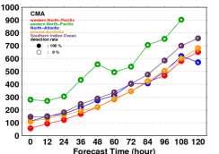
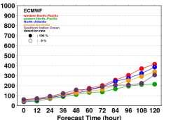
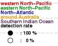
27 Western North Pacific transition of FT+72 position error over decade(s) Eastern North Pacific North Atlantic Southern Indian Ocean around Australia North Indian Ocean
28 (a) western North-Pacific (WNP) domain Position Error for
29 SUMMARY 30
30 Summary JMA began to operate NWP in 1959 and the models will be upgraded. WGNE encourages numerical model development for both NWP and climate. TC verification of WGNE shows remarkable improvement of operational Global NWP models in all centers. Enhancement of resolution, physical process and data assimilation are key points. 31
31 36
32 Data assimilation systems of NPD/JMA Global Analysis (GA) Meso-scale Analysis (MA) Local Analysis (LA) Analysis scheme 4DVar 3DVar Analysis time 00, 06, 12, 18 UTC 00, 03, 06, 09, 12, 15, 18, 21 UTC hourly Data cut-off time 2 hours 20 minutes [Early Analysis] 11 hours 50 minutes (00, 12 UTC) 7 hours 50 minutes (06, 18 UTC) [Cycle Analysis] 50 minutes 30 minutes Horizontal resolution (inner-model resolution) T L 959 / deg (T L 319 / deg) 5 km (15 km) 5km Vertical levels 60 levels up to 0.1 hpa 50 levels up to 21.8km 50 levels up to 21.8km Assimilation window -3 hours to +3 hours of analysis time -3 hours to analysis time -
33 RMSE of geopotential height (m) Smaller error Verification score of global model 80 GSM Z500(20N-90N) RMSE 00UTC/12UTC 1-day forecast 2-day forecast 3-hour forecast 24h_Fcst 48h_Fcst 72h_Fcst Ave(24h) Ave(48h) Ave(72h) _12L- 1985_12L- 1986_12L- 1987_12L- 1988_16L- 1989_16L- 1990_21L- 1991_21L- 1992_21L- 1993_21L- 1994_21L- 1995_21L- 1996_30L- 1997_30L- 1998_30L- RMSE of 500 hpa geopotential height in Northern Hemisphere (20-90N) The accuracy of 3-day forecast in 2011 compares with that of 1-day forecast in 1980 s. 1999_30L- 2000_30L- 2001_40L- 2002_40L- 2003_40L- 2004_40L- 2005_40L- 2006_40L- 2007_40L- 2008_60L- 2009_60L L L L- 38

34 Example of Typhoon Forecast by 20km-GSM Accuracy of current NWP is generally good. GSM predicted typhoons track well Obs. 39
35 40
 (September 2013) MW imager data coverage.gcom-w1/amsr2 data fill the gaps.")

36 Recent improvements of Global data assimilation system Enhancement of utilized atmospheric motion vectors (AMVs) (July 2013) AMV data coverage. The red rectangles indicate areas covered by LEOGEO AMVs. Introduction of AMSR2 onboard GCOM-W1 (Japanese name: Shizuku) (September 2013) MW imager data coverage.gcom-w1/amsr2 data fill the gaps. Note: DMSP-F16 and F17 had almost the same coverage as of summer Introduction of data from Metop-B Mean TC position errors (in km) as a function of forecast time up to 84 hours in summer The red and blue lines indicate errors of forecasts with and without Metop-B data, respectively. The dots correspond to the vertical axis on the right, which represents the number of verification samples. with Metop-B w/o Metop-B DMSP-F16/SSMIS DMSP-F17/SSMIS DMSP-F18/SSMIS GCOM- W1/AMSR2 TRMM/TMI 41

37 Enhancement of GSM (Mar 2014) JMA also plans to upgrade its operational GSM. The number of vertical levels in GSM will be enhanced from 60 to 100 the top level of the model will be raised from 0.1 hpa to 0.01 hpa. The physical processes will be revised. L60 L100 42
38 Ensemble settings EPS model and its integration Plans to upgrade JMA s global EPSs (Mar 2014) Specifications of JMA s medium-range EPSs (red: upgrade plan) One-week EPS Typhoon EPS Objectives One-week Forecasts TC Information Model type Horizontal resolution Vertical levels GSM (an atmospheric general circulation model) TL319 (~55km) TL479 (~40km) 60 levels, up to 0.1 hpa Forecast range 264 hours (12UTC) 264 hours (00, 12UTC) 132 hours(00,06,12,18utc) only when Tropical Cyclones of TS/STS/TY intensity are present or are expected to appear in the RSMC Tokyo Typhoon Centre s area of responsibility Member (per day) (51/day 54/day) (44/day 100/day) Initial perturbation SV method, Three target areas (NH,TR,SH) SV method, One fixed target area (the Northwestern Pacific) and up to 3 movable target areas (vicinities of up to 3 TCs) Model ensemble Stochastic physics 43
39 Horizontal resolution Upgrade Supercomputer system Strategy TL319L60M51 60km 40km 1-week Global Ensemble Typhoon Global Ensemble TL319L60M11 TL479L60M27 Twice per day TL479L60M25 TL479L100M27 Twice per day TL479L100M25 Global Ensemble TL479L100M27 20km Global Model TL959L60 11days forecast TL959L100 10km 5km Meso-Scale Model 5kmL50 39hours forecast Meso-scale Ensemble 10km 5kmL75 2km Local Forecast Model 2kmL60 Every 3 hours 9hours forecast Eastern Japan region Hourly Whole Japan region

40 WGNE TC VERIFICATION 45
41 WGNE Numerical Weather Prediction (CAS) and Climate (WCRP) Working interface between operational forecasting and climate modelling communities WGNE fosters the open exchange of information in a competitive NWP environment WGNE theme: atmospheric models, their evaluation and improvement 46

42 WGNE Activities Meeting Related Workshop 4th WGNE workshop on systematic errors in weather and climate models, Exeter, UK, April 2013 Publication Blue Book: Research Activities in Atmospheric and Ocean Modelling Intercomparison, Verification Tropical Cyclone Precipitation Surface drag Impact of aerosol 47
43 WGNE intercomparison of Tropical Cyclone Track forecast, 2011 Chiashi Muroi, colleagues at JMA, and WGNE-Friends 5-9 Nov. 2012, Toulouse WGNE-28
44 History of the Project 1991 : commencement with three centers: ECMWF, UKMO and JMA. The verification area was only western North Pacific : CMC joined : Verification for the North Atlantic started : DWD joined. Verification for the eastern North Pacific started : Verification for 2 Southern Hemispheric regions, north Indian Ocean and the Central Pacific started : NCEP and BoM joined. A website for this intercomparison project was launched : Meteo-France and CMA joined : CPTEC and NRL joined : KMA joined. CMAcame back. 2012: 11 NWP centers participated in the project. BOM CMA CMC DWD ECMWF JMA KMA France NCEP NRL UKMO
45 NWP centers Participate Year Bogus data Horizontal Res. of provided data Model Res. as of 2011 BoM x kmL50 CMA 2004 used 1.25x1.25 T L 639L60 CMC x1.0 33km L60 DWD ECMWF JMA 1991 used in WNP Specification of Data 0.36x0.36(2010) 0.25x0.25(2011) 0.25x0.25(2010) 0.125x0.125(2011) 0.5x0.5(2010) 0.125x0.125(2011) KMA 2011 used 1.25x kmL60 T L 1279L91 T L 959L60 40kmL50 25kmL70(23 May ~) France 2004 used* 0.5x0.5 T L 798C2.4L70 NCEP 2003 used in rare case 1.0x1.0 T574 L64 NRL** 2006 used 1.0x1.0 T239L30 UKMO 1991 used x kmL70 * except for South Pacific and north Indian-Ocean **Data from July 2011 to October 2011 are almost
46 Method of TC verification using MSLP TCs to be verified TCs which intensity reached tropical storm (TS) with the maximum sustained wind of 34 knots or stronger are set as targets for this verification. The tropical depression (TD) stage of the targeted TCs is also included in this verification. However, the TCs which stayed at TD level all through their life are excluded. 1. Tracking Method local pressure minimum; a) First position (FT +0hr) : search from the best track position b) Second position (FT +12hr) : search from the first position c) Third and after (FT +24hr~) : search from estimated position from the latest two positions (all position searched within 500km radius)
-bias : The bias in the direction of TC movement CT(cross-track)-bias : The bias in the rectangular")

47 2. Verification Method Position Error km The distance between the best-track (analyzed) position and the forecast position. Along Track Cross Track bias AT(along-track)-bias : The bias in the direction of TC movement CT(cross-track)-bias : The bias in the rectangular direction of TC movement Detection Rate % Detection Rate (t) = A(t)/ B(t) A(t) : The number of forecast events in which a TC is analyzed at forecast time t on the condition that a NWP model continuously expresses the TC until the forecast time t. B(t) : The number of forecast events in which a TC is analyzed at forecast time t.
![TC Verification TC tracks on 2011 season Northern-Hemisphere [2011/01/01 to 2011/12/31] Southern-Hemisphere [2010/09/01 to 2011/08/31] Number of TCs, [best-track data provider] 21 western](/docs-images/85/91872392/images/48-0.jpg "North-Pacific [RSMC Tokyo] 11 eastern North-Pacific (including Central-Pacific) [RSMC Miami, Honolulu] 19 North Atlantic [RSMC Miami] 2 north Indian-Ocean [RSMC New-Delhi] 3 south Indian-Ocean [RSMC")
48 TC Verification TC tracks on 2011 season Northern-Hemisphere [2011/01/01 to 2011/12/31] Southern-Hemisphere [2010/09/01 to 2011/08/31] Number of TCs, [best-track data provider] 21 western North-Pacific [RSMC Tokyo] 11 eastern North-Pacific (including Central-Pacific) [RSMC Miami, Honolulu] 19 North Atlantic [RSMC Miami] 2 north Indian-Ocean [RSMC New-Delhi] 3 south Indian-Ocean [RSMC La-Reunion] the lowest number of tropical cyclones for 50 years 15 around Australia [RSMC Nadi and 4 TCWCs ] (Except for Errol and Bune 13 typhoons was actually

49 (a) western North-Pacific (WNP) domain Position Error 21 TCs in 2011
50 (a) WNP domain Detection Rate DetectionRate Position Error map (FT +72)
51 (a) WNP domain AT-CT bias map (FT +72) JMA ECMWF UKMO CMC DWD NCEP KMA BOM Meteo France CMA Scatter diagram of TC positions at 72 hour forecast. Red : Before recurvature Green : During recurvature Blue : After recurvature Y-axis represents position errors in Along Track (AT) direction and X-axis does that in Cross Track (CT) direction. Unit: km
52 (a) WNP domain Central Pressure scatter diagram (FT +72) JMA ECMWF UKMO CMC DWD NCEP KMA BOM Meteo France CMA Scatter diagram of central pressure at 72 hour forecast. Y-axis represents central pressure of forecast and X-axis does that of analysis. Unit: hpa


53 visualization with pie-chart BOM CMA CMC DWD ECMWF Meteo France JMA KMA NCEP NRL UKMO


")


54 Western North Pacific transition of FT+72 position error over decade(s) Eastern North Pacific North Atlantic Southern Indian Ocean around Australia North Indian Ocean
55 (a) western North-Pacific (WNP) domain Position Error for

56 SUMMARY 61
57 Summary WGNE encourages numerical model development for both NWP and climate. TC verification of WGNE shows remarkable improvement of operational Global NWP models in all centers. Enhancement of resolution, physical process and data assimilation are key points. Verification of TC intensity, genesis and EPS will be issues. 62
Recent Developments of JMA Operational NWP Systems and WGNE Intercomparison of Tropical Cyclone Track Forecast
 Recent Developments of JMA Operational NWP Systems and WGNE Intercomparison of Tropical Cyclone Track Forecast Masayuki Nakagawa and colleagues at JMA Numerical Prediction Division Japan Meteorological
WGNE intercomparison of Tropical Cyclone Track forecast, 2007
 WGNE intercomparison of Tropical Cyclone Track forecast, 2007 Chiashi Muroi Numerical Prediction Division Prepared by Hirokatsu Onoda and Takuya Komori (NPD/JMA) History of Project 1991 : It began with
Activities of Numerical Weather Prediction for Typhoon forecast at Japan Meteorological Agency
 Activities of Numerical Weather Prediction for Typhoon forecast at Japan Meteorological Agency Masayuki Nakagawa Numerical Prediction Division Japan Meteorological Agency ESCAP/WMO Typhoon Committee Forty-ninth
Current JMA ensemble-based tools for tropical cyclone forecasters
 Current JMA ensemble-based tools for tropical cyclone forecasters Hitoshi Yonehara(yonehara@met.kishou.go.jp) Yoichiro Ota JMA / Numerical Prediction Division Contents Introduction of JMA GSM and EPS NWP
Upgrade of JMA s Typhoon Ensemble Prediction System
 Upgrade of JMA s Typhoon Ensemble Prediction System Masayuki Kyouda Numerical Prediction Division, Japan Meteorological Agency and Masakazu Higaki Office of Marine Prediction, Japan Meteorological Agency
AN OBSERVING SYSTEM EXPERIMENT OF MTSAT RAPID SCAN AMV USING JMA MESO-SCALE OPERATIONAL NWP SYSTEM
 AN OBSERVING SYSTEM EXPERIMENT OF MTSAT RAPID SCAN AMV USING JMA MESO-SCALE OPERATIONAL NWP SYSTEM Koji Yamashita Japan Meteorological Agency / Numerical Prediction Division 1-3-4, Otemachi, Chiyoda-ku,
IMPACT STUDIES OF AMVS AND SCATTEROMETER WINDS IN JMA GLOBAL OPERATIONAL NWP SYSTEM
 IMPACT STUDIES OF AMVS AND SCATTEROMETER WINDS IN JMA GLOBAL OPERATIONAL NWP SYSTEM Koji Yamashita Japan Meteorological Agency / Numerical Prediction Division 1-3-4, Otemachi, Chiyoda-ku, Tokyo 100-8122,
Observing system experiments of MTSAT-2 Rapid Scan Atmospheric Motion Vector for T-PARC 2008 using the JMA operational NWP system
 Tenth International Winds Workshop 1 Observing system experiments of MTSAT-2 Rapid Scan Atmospheric Motion Vector for T-PARC 2008 using the JMA operational NWP system Koji Yamashita Japan Meteorological
Assimilation of Himawari-8 Atmospheric Motion Vectors into the Numerical Weather Prediction Systems of Japan Meteorological Agency
 Assimilation of Himawari-8 Atmospheric Motion Vectors into the Numerical Weather Prediction Systems of Japan Meteorological Agency Koji Yamashita Japan Meteorological Agency kobo.yamashita@met.kishou.go.jp,
Operational Use of Scatterometer Winds at JMA
 Operational Use of Scatterometer Winds at JMA Masaya Takahashi Numerical Prediction Division, Japan Meteorological Agency (JMA) 10 th International Winds Workshop, Tokyo, 26 February 2010 JMA Outline JMA
Study for utilizing high wind speed data in the JMA s Global NWP system
 Study for utilizing high wind speed data in the JMA s Global NWP system Masami Moriya Numerical Prediction Division, Japan Meteorological Agency (JMA) IOVWST Meeting, Portland, USA, 19-21 May 2015 1 Contents
Masahiro Kazumori, Takashi Kadowaki Numerical Prediction Division Japan Meteorological Agency
 Development of an all-sky assimilation of microwave imager and sounder radiances for the Japan Meteorological Agency global numerical weather prediction system Masahiro Kazumori, Takashi Kadowaki Numerical
4.3.2 Configuration. 4.3 Ensemble Prediction System Introduction
 4.3 Ensemble Prediction System 4.3.1 Introduction JMA launched its operational ensemble prediction systems (EPSs) for one-month forecasting, one-week forecasting, and seasonal forecasting in March of 1996,
A review on recent progresses of THORPEX activities in JMA
 4th THORPEX workshop 31 Oct. 2012, Kunming, China A review on recent progresses of THORPEX activities in JMA Masaomi NAKAMURA Typhoon Research Department Meteorological Research Institute / JMA Contents
The Improvement of JMA Operational Wave Models
 The Improvement of JMA Operational Wave Models Toshiharu Tauchi Nadao Kohno * Mika Kimura Japan Meteorological Agency * (also) Meteorological Research Institute, JMA 10 th International Workshop on Wave
Recent activities related to EPS (operational aspects)
") Recent activities related to EPS (operational aspects) Junichi Ishida and Carolyn Reynolds With contributions from WGE members 31th WGE Pretoria, South Africa, 26 29 April 2016 GLOBAL 2 Operational global
Recent activities related to EPS (operational aspects) Junichi Ishida and Carolyn Reynolds With contributions from WGE members 31th WGE Pretoria, South Africa, 26 29 April 2016 GLOBAL 2 Operational global
Satellite Soil Moisture Content Data Assimilation in Operational Local NWP System at JMA
 Satellite Soil Moisture Content Data Assimilation in Operational Local NWP System at JMA Yasutaka Ikuta Numerical Prediction Division Japan Meteorological Agency Acknowledgment: This research was supported
11 days (00, 12 UTC) 132 hours (06, 18 UTC) One unperturbed control forecast and 26 perturbed ensemble members. --
 132 hours (06, 18 UTC) One unperturbed control forecast and 26 perturbed ensemble members. --") APPENDIX 2.2.6. CHARACTERISTICS OF GLOBAL EPS 1. Ensemble system Ensemble (version) Global EPS (GEPS1701) Date of implementation 19 January 2017 2. EPS configuration Model (version) Global Spectral Model
APPENDIX 2.2.6. CHARACTERISTICS OF GLOBAL EPS 1. Ensemble system Ensemble (version) Global EPS (GEPS1701) Date of implementation 19 January 2017 2. EPS configuration Model (version) Global Spectral Model
Precipitation verification. Thanks to CMC, CPTEC, DWD, ECMWF, JMA, MF, NCEP, NRL, RHMC, UKMO
 Precipitation verification Thanks to CMC, CPTEC, DWD, ECMWF, JMA, MF, NCEP, NRL, RHMC, UKMO Outline 1) Status of WGNE QPF intercomparisons 2) Overview of the use of recommended methods for the verification
The benefits and developments in ensemble wind forecasting
 The benefits and developments in ensemble wind forecasting Erik Andersson Slide 1 ECMWF European Centre for Medium-Range Weather Forecasts Slide 1 ECMWF s global forecasting system High resolution forecast
2016 and 2017 Reviews of Probability-circle Radii in Tropical Cyclone Track Forecasts
 216 and 217 Reviews of Probability-circle Radii in Tropical Cyclone Track Forecasts Junya Fukuda Tokyo Typhoon Center, Forecast Division, Forecast Department, Japan Meteorological Agency 1. Introduction
Reduction of the Radius of Probability Circle. in Typhoon Track Forecast
 Reduction of the Radius of Probability Circle in Typhoon Track Forecast Nobutaka MANNOJI National Typhoon Center, Japan Meteorological Agency Abstract RSMC Tokyo - Typhoon Center of the Japan Meteorological
Development of JMA storm surge model
 2 nd JCOMM Scientific and Technical Symposium on Storm Surges 8-13 November 2015, Key West, Florida, USA Development of JMA storm surge model Hiroshi HASEGAWA (h_hasegawa@met.kishou.go.jp) Office of Marine
Recent development at JMA (short-range and medium-range NWP)
") Recent development at JMA (short-range and medium-range NWP) Chiashi Muroi Numerical Prediction Division Japan Meteorological Agency Major changes in operational run Deterministic (short-range and medium-range)
Recent development at JMA (short-range and medium-range NWP) Chiashi Muroi Numerical Prediction Division Japan Meteorological Agency Major changes in operational run Deterministic (short-range and medium-range)
JMA Contribution to SWFDDP in RAV. (Submitted by Yuki Honda and Masayuki Kyouda, Japan Meteorological Agency) Summary and purpose of document
 Summary and purpose of document") WORLD METEOROLOGICAL ORGANIZATION COMMISSION FOR BASIC SYSTEMS OPAG on DPFS DPFS/RAV-SWFDDP-RSMT Doc. 7.1(1) (28.X.2010) SEVERE WEATHER FORECASTING AND DISASTER RISK REDUCTION DEMONSTRATION PROJECT (SWFDDP)
WORLD METEOROLOGICAL ORGANIZATION COMMISSION FOR BASIC SYSTEMS OPAG on DPFS DPFS/RAV-SWFDDP-RSMT Doc. 7.1(1) (28.X.2010) SEVERE WEATHER FORECASTING AND DISASTER RISK REDUCTION DEMONSTRATION PROJECT (SWFDDP)
TIGGE at ECMWF. David Richardson, Head, Meteorological Operations Section Slide 1. Slide 1
 TIGGE at ECMWF David Richardson, Head, Meteorological Operations Section david.richardson@ecmwf.int Slide 1 Slide 1 ECMWF TIGGE archive The TIGGE database now contains five years of global EPS data Holds
Annual Report on the Activities of the RSMC Tokyo - Typhoon Center 2012
 Annual Report on the Activities of the RSMC Tokyo - Typhoon Center 2012 TY Sanba 00 UTC, 14 September 2012 Japan Meteorological Agency Annual Report on the Activities of the RSMC Tokyo - Typhoon Center
Operational Use of Scatterometer Winds in the JMA Data Assimilation System
 Operational Use of Scatterometer Winds in the Data Assimilation System Masaya Takahashi Numerical Prediction Division, Japan Meteorological Agency () International Ocean Vector Winds Science Team Meeting,
Status and Plans of using the scatterometer winds in JMA's Data Assimilation and Forecast System
 Status and Plans of using the scatterometer winds in 's Data Assimilation and Forecast System Masaya Takahashi¹ and Yoshihiko Tahara² 1- Numerical Prediction Division, Japan Meteorological Agency () 2-
11A.3 The Impact on Tropical Cyclone Predictions of a Major Upgrade to the Met Office Global Model
 11A.3 The Impact on Tropical Cyclone Predictions of a Major Upgrade to the Met Office Global Model Julian T. Heming * Met Office, Exeter, UK 1. BACKGROUND TO MODEL UPGRADE The last major upgrade to the
Tropical cyclone track forecasts using JMA model with ECMWF and JMA initial conditions
 Tropical cyclone track forecasts using JMA model with ECMWF and JMA initial conditions The Fourth THORPEX Asian Science Workshop Kunming, China 2 Nov 2012 (Fri) Munehiko Yamaguchi 1, Tetsuo Nakazawa 1,2
North Western Pacific Tropical Cyclone (Track) Ensemble Forecast Research Project (NW Pacific TC Project)
 Ensemble Forecast Research Project (NW Pacific TC Project)") TIGGE Real-Time Tropical Cyclone Data for Regional Applications North Western Pacific Tropical Cyclone (Track) Ensemble Forecast Research Project (NW Pacific TC Project) a WWRP Research Development Project
TIGGE Real-Time Tropical Cyclone Data for Regional Applications North Western Pacific Tropical Cyclone (Track) Ensemble Forecast Research Project (NW Pacific TC Project) a WWRP Research Development Project
Application of NWP products and meteorological information processing system in Hong Kong
 Application of NWP products and meteorological information processing system in Hong Kong Y.S. Li Scientific Officer Hong Kong Observatory (ysli@hko.gov.hk) 7 million people Hong Kong ~1,100 km sq. Regional
Assimilation of Himawari-8 data into JMA s NWP systems
 Assimilation of Himawari-8 data into JMA s NWP systems Masahiro Kazumori, Koji Yamashita and Yuki Honda Numerical Prediction Division, Japan Meteorological Agency 1. Introduction The new-generation Himawari-8
Annual Report on the Activities of the RSMC Tokyo - Typhoon Center 2014
 Annual Report on the Activities of the RSMC Tokyo - Typhoon Center 2014 TY Vongfong 23 UTC, 7 October 2014 Japan Meteorological Agency Annual Report on the Activities of the RSMC Tokyo - Typhoon Center
Quarterly numerical weather prediction model performance summaries April to June 2010 and July to September 2010
 Australian Meteorological and Oceanographic Journal 60 (2010) 301-305 Quarterly numerical weather prediction model performance summaries April to June 2010 and July to September 2010 Xiaoxi Wu and Chris
Current Issues and Challenges in Ensemble Forecasting
 Current Issues and Challenges in Ensemble Forecasting Junichi Ishida (JMA) and Carolyn Reynolds (NRL) With contributions from WGNE members 31 th WGNE Pretoria, South Africa, 26 29 April 2016 Recent trends
1. Introduction. 2. Verification of the 2010 forecasts. Research Brief 2011/ February 2011
 Research Brief 2011/01 Verification of Forecasts of Tropical Cyclone Activity over the Western North Pacific and Number of Tropical Cyclones Making Landfall in South China and the Korea and Japan region
Recent advances in Tropical Cyclone prediction using ensembles
 Recent advances in Tropical Cyclone prediction using ensembles Richard Swinbank, with thanks to Many colleagues in Met Office, GIFS-TIGGE WG & others HC-35 meeting, Curacao, April 2013 Recent advances
GIFS-TIGGE working group Report to ICSC. Richard Swinbank Masayuki Kyouda with thanks to other members of GIFS-TIGGE WG and the THORPEX IPO
 GIFS-TIGGE working group Report to ICSC Richard Swinbank Masayuki Kyouda with thanks to other members of GIFS-TIGGE WG and the THORPEX IPO ICSC-11, Geneva, July 2013 GIFS-TIGGE report Working group membership
The ECMWF Extended range forecasts
 The ECMWF Extended range forecasts Laura.Ferranti@ecmwf.int ECMWF, Reading, U.K. Slide 1 TC January 2014 Slide 1 The operational forecasting system l High resolution forecast: twice per day 16 km 91-level,
ECMWF Medium-Range Forecast Graphical Products
 ECMWF Medium-Range Forecast Graphical Products Analysis Snow cover, ice cover, albedo, leaf area index, orography and sea depth Albedo Europe, Global, Central Europe, North West Europe, North East Europe,
Introduction to TIGGE and GIFS. Richard Swinbank, with thanks to members of GIFS-TIGGE WG & THORPEX IPO
 Introduction to TIGGE and GIFS Richard Swinbank, with thanks to members of GIFS-TIGGE WG & THORPEX IPO GIFS-TIGGE/NCAR/NOAA Workshop on EPS developments, June 2012 TIGGE THORPEX Interactive Grand Global
Global and Regional OSEs at JMA
 Global and Regional OSEs at JMA Yoshiaki SATO and colleagues Japan Meteorological Agency / Numerical Prediction Division 1 JMA NWP SYSTEM Global OSEs Contents AMSU A over coast, MHS over land, (related
MJO prediction Intercomparison using the S2S Database Frédéric Vitart (ECMWF)
") MJO prediction Intercomparison using the S2S Database Frédéric Vitart (ECMWF) Slide 1 WGNE Meeting 29 April 2016 1 INDEX The S2S project and S2S Database MJO prediction in S2S models MJO teleconnections
MJO prediction Intercomparison using the S2S Database Frédéric Vitart (ECMWF) Slide 1 WGNE Meeting 29 April 2016 1 INDEX The S2S project and S2S Database MJO prediction in S2S models MJO teleconnections
Observing System Experiments using a singular vector method for 2004 DOTSTAR cases
 Observing System Experiments using a singular vector method for 2004 DOTSTAR cases Korea-Japan-China Second Joint Conference on Meteorology 11 OCT. 2006 Munehiko YAMAGUCHI 1 Takeshi IRIGUCHI 1 Tetsuo NAKAZAWA
AVIATION APPLICATIONS OF A NEW GENERATION OF MESOSCALE NUMERICAL WEATHER PREDICTION SYSTEM OF THE HONG KONG OBSERVATORY
 P452 AVIATION APPLICATIONS OF A NEW GENERATION OF MESOSCALE NUMERICAL WEATHER PREDICTION SYSTEM OF THE HONG KONG OBSERVATORY Wai-Kin WONG *1, P.W. Chan 1 and Ivan C.K. Ng 2 1 Hong Kong Observatory, Hong
Microwave-TC intensity estimation. Ryo Oyama Meteorological Research Institute Japan Meteorological Agency
 Microwave-TC intensity estimation Ryo Oyama Meteorological Research Institute Japan Meteorological Agency Contents 1. Introduction 2. Estimation of TC Maximum Sustained Wind (MSW) using TRMM Microwave
Upgraded usage of MODIS-derived polar winds in the JMA operational global 4D-Var assimilation system
 1 Upgraded usage of MODIS-derived polar winds in the JMA operational global 4D-Var assimilation system Koji Yamashita Japan Meteorological Agency Kobo.yamashita@met.kishou.go.jp Background Objectives 2
HIGH SPATIAL AND TEMPORAL RESOLUTION ATMOSPHERIC MOTION VECTORS GENERATION, ERROR CHARACTERIZATION AND ASSIMILATION
 HIGH SPATIAL AND TEMPORAL RESOLUTION ATMOSPHERIC MOTION VECTORS GENERATION, ERROR CHARACTERIZATION AND ASSIMILATION John Le Marshall Director, JCSDA 2004-2007 CAWCR 2007-2010 John Le Marshall 1,2, Rolf
Verification statistics and evaluations of ECMWF forecasts in
 635 Verification statistics and evaluations of ECMWF forecasts in 29-21 D.S. Richardson, J. Bidlot, L. Ferranti, A. Ghelli, T. Hewson, M. Janousek, F. Prates and F. Vitart Operations Department October
ACTIVITIES OF THE RSMC TOKYO - TYPHOON CENTER IN 2010
 ECONOMIC AND SOCIAL COMMISSION FOR ASIA AND THE PACIFIC AND WORLD METEOROLOGICAL ORGANIZATION WRD/TC.43/5.1 Add. 2 18 January 2011 Typhoon Committee Forty Third Session 17 to 22 January 2011 Jeju, Republic
Total Energy Singular Vector Guidance Developed at JMA for T-PARC
 Total Energy Singular Vector Guidance Developed at JMA for T-PARC Takuya Komori Numerical Prediction Division, Japan Meteorological Agency Ryota Sakai River Office, Osaka Prefectural Government Hitoshi
How far in advance can we forecast cold/heat spells?
 Sub-seasonal time scales: a user-oriented verification approach How far in advance can we forecast cold/heat spells? Laura Ferranti, L. Magnusson, F. Vitart, D. Richardson, M. Rodwell Danube, Feb 2012
Assimilation of GNSS Radio Occultation Data at JMA. Hiromi Owada, Yoichi Hirahara and Masami Moriya Japan Meteorological Agency
 Assimilation of GNSS Radio Occultation Data at JMA Hiromi Owada, Yoichi Hirahara and Masami Moriya Japan Meteorological Agency COSMIC-IROWG 2017, 21-27 September 2017 1 Outline Current RO data utilization
Interpretation of Outputs from Numerical Prediction System
 Interpretation of Outputs from Numerical Prediction System Hiroshi OHNO Tokyo Climate Center (TCC)/ Climate Prediction Division of Japan Meteorological Agency (JMA) Procedure of Seasonal Forecast (1) 1.
RECENT UPGRADES OF AND ACTIVITIES FOR ATMOSPHERIC MOTION VECTORS AT JMA/MSC
 1 th International Winds Workshop, Tokyo, Japan, - ruary 1 RECENT UPGRADES OF AND ACTIVITIES FOR ATMOSPHERIC MOTION VECTORS AT JMA/MSC Ryo OYAMA Meteorological Satellite Center of Japan Meteorological
Systematic Errors in the ECMWF Forecasting System
 Systematic Errors in the ECMWF Forecasting System Thomas Jung ECMWF Introduction Two principal sources of forecast error: Uncertainties in the initial conditions Model error How to identify model errors?
Recent Developments in Climate Information Services at JMA. Koichi Kurihara Climate Prediction Division, Japan Meteorological Agency
 Recent Developments in Climate Information Services at JMA Koichi Kurihara Climate Prediction Division, Japan Meteorological Agency 1 Topics 1. Diagnosis of the Northern Hemispheric circulation in December
STATUS OF JAPANESE METEOROLOGICAL SATELLITES AND RECENT ACTIVITIES OF MSC
 STATUS OF JAPANESE METEOROLOGICAL SATELLITES AND RECENT ACTIVITIES OF MSC Daisaku Uesawa Meteorological Satellite Center, Japan Meteorological Agency Abstract MTSAT-1R is the current operational Japanese
(April 7, 2010, Wednesday) Tropical Storms & Hurricanes Part 2
 Tropical Storms & Hurricanes Part 2") Lecture #17 (April 7, 2010, Wednesday) Tropical Storms & Hurricanes Part 2 Hurricane Katrina August 2005 All tropical cyclone tracks (1945-2006). Hurricane Formation While moving westward, tropical disturbances
Lecture #17 (April 7, 2010, Wednesday) Tropical Storms & Hurricanes Part 2 Hurricane Katrina August 2005 All tropical cyclone tracks (1945-2006). Hurricane Formation While moving westward, tropical disturbances
Scatterometer Utilization in JMA s global numerical weather prediction (NWP) system
 system") Scatterometer Utilization in JMA s global numerical weather prediction (NWP) system Masami Moriya Numerical Prediction Division, Japan Meteorological Agency (JMA) IOVWST Meeting, Brest, France, 2-4 June
Scatterometer Utilization in JMA s global numerical weather prediction (NWP) system Masami Moriya Numerical Prediction Division, Japan Meteorological Agency (JMA) IOVWST Meeting, Brest, France, 2-4 June
South Asian Climate Outlook Forum (SASCOF-12)
") Twelfth Session of South Asian Climate Outlook Forum (SASCOF-12) Pune, India, 19-20 April 2018 Consensus Statement Summary Normal rainfall is most likely during the 2018 southwest monsoon season (June
Twelfth Session of South Asian Climate Outlook Forum (SASCOF-12) Pune, India, 19-20 April 2018 Consensus Statement Summary Normal rainfall is most likely during the 2018 southwest monsoon season (June
The Impacts on Extended-Range Predictability of Midlatitude Weather Patterns due to Recurving Tropical Cyclones
 The Impacts on Extended-Range Predictability of Midlatitude Weather Patterns due to Recurving Tropical Cyclones Patrick A. Harr and Heather M. Archambault Naval Postgraduate School, Monterey, CA Hurricane
The Impact of Observational data on Numerical Weather Prediction. Hirokatsu Onoda Numerical Prediction Division, JMA
 The Impact of Observational data on Numerical Weather Prediction Hirokatsu Onoda Numerical Prediction Division, JMA Outline Data Analysis system of JMA in Global Spectral Model (GSM) and Meso-Scale Model
WMO LC-LRFMME Website User Manual
 WMO LC-LRFMME Website User Manual World Meteorological Organization Lead Centre for Long-Range Forecast Multi-Model Ensemble Last update: August 2016 Contents 1. WMO LC-LRFMME Introduction... 1 1.1. Overview
South Asian Climate Outlook Forum (SASCOF-6)
") Sixth Session of South Asian Climate Outlook Forum (SASCOF-6) Dhaka, Bangladesh, 19-22 April 2015 Consensus Statement Summary Below normal rainfall is most likely during the 2015 southwest monsoon season
Sixth Session of South Asian Climate Outlook Forum (SASCOF-6) Dhaka, Bangladesh, 19-22 April 2015 Consensus Statement Summary Below normal rainfall is most likely during the 2015 southwest monsoon season
Tropical Storm List
 Tropical Storm Email List http://tstorms.org/ tropical-storms@tstorms.org Tropical-Storms is a mailing list only for those who are professionally active in either the research or forecasting of tropical
The JRA-55 Reanalysis: quality control and reprocessing of observational data
 The JRA-55 Reanalysis: quality control and reprocessing of observational data Kazutoshi Onogi On behalf of JRA group Japan Meteorological Agency 29 October 2014 EASCOF 1 1. Introduction 1. Introduction
Severe weather warnings at the Hungarian Meteorological Service: Developments and progress
 Severe weather warnings at the Hungarian Meteorological Service: Developments and progress István Ihász Hungarian Meteorological Service Edit Hágel Hungarian Meteorological Service Balázs Szintai Department
T-PARC and TCS08 (Submitted by Pat Harr, Russell Elsberry and Tetsuo Nakazawa)
") WORLD METEOROLOGICAL ORGANIZATION COMMISSION FOR ATMOSPHERIC SCIENCES INTERNATIONAL CORE STEERING COMMITTEE FOR THORPEX Eighth Session DWD, Offenbach (2 4 November 2009) CAS/ICSC-8/DOC4.1 (3 X.2009) Item:
WORLD METEOROLOGICAL ORGANIZATION COMMISSION FOR ATMOSPHERIC SCIENCES INTERNATIONAL CORE STEERING COMMITTEE FOR THORPEX Eighth Session DWD, Offenbach (2 4 November 2009) CAS/ICSC-8/DOC4.1 (3 X.2009) Item:
Earth Observation & forecasting Storm Surges in the North Western Pacific. Mr. Nadao Kohno Japan Meteorological Agency
 Earth Observation & forecasting Storm Surges in the North Western Pacific Mr. Nadao Kohno Japan Meteorological Agency Lesson Outline Introduction JMA s responsibility and work as a RSMC, Tokyo Typhoon
2014/2/25. Earth Observation & forecasting Storm Surges in the North Western Pacific. Lesson Outline. RSMC Tokyo Typhoon Center.
 Earth Observation & forecasting Storm Surges in the North Western Pacific Mr. Nadao Kohno Japan Meteorological Agency Lesson Outline Introduction JMA s responsibility and work as a RSMC, Tokyo Typhoon
STATUS ON THE USE OF SCATTEROMETER DATA AT METEO FRANCE
 STATUS ON THE USE OF SCATTEROMETER DATA AT METEO FRANCE Christophe Payan Centre National de Recherches Météorologiques, M CNRS-GAME CNRS and Météo-France Toulouse, France 9th International Winds Workshop,
Current status and plans of JMA operational wind product
 Current status and plans of JMA operational wind product Kazuki Shimoji Japan Meteorological Agency / Meteorological Satellite Center 3-235, Nakakiyoto, Kiyose, Tokyo, Japan Abstract The Meteorological
IMPROVEMENTS IN FORECASTS AT THE MET OFFICE THROUGH REDUCED WEIGHTS FOR SATELLITE WINDS. P. Butterworth, S. English, F. Hilton and K.
 IMPROVEMENTS IN FORECASTS AT THE MET OFFICE THROUGH REDUCED WEIGHTS FOR SATELLITE WINDS P. Butterworth, S. English, F. Hilton and K. Whyte Met Office London Road, Bracknell, RG12 2SZ, UK ABSTRACT Following
South Asian Climate Outlook Forum (SASCOF-8)
") Eighth Session of South Asian Climate Outlook Forum (SASCOF-8) Colombo, Sri Lanka, 25-26 April 2016 Consensus Statement Summary Above-normal rainfall is most likely during the 2016 southwest monsoon season
Eighth Session of South Asian Climate Outlook Forum (SASCOF-8) Colombo, Sri Lanka, 25-26 April 2016 Consensus Statement Summary Above-normal rainfall is most likely during the 2016 southwest monsoon season
The impact of assimilation of microwave radiance in HWRF on the forecast over the western Pacific Ocean
 The impact of assimilation of microwave radiance in HWRF on the forecast over the western Pacific Ocean Chun-Chieh Chao, 1 Chien-Ben Chou 2 and Huei-Ping Huang 3 1Meteorological Informatics Business Division,
Ninth Workshop on Meteorological Operational Systems. Timeliness and Impact of Observations in the CMC Global NWP system
 Ninth Workshop on Meteorological Operational Systems ECMWF, Reading, United Kingdom 10 14 November 2003 Timeliness and Impact of Observations in the CMC Global NWP system Réal Sarrazin, Yulia Zaitseva
Development Project High Resolution Numerical Prediction of Landfalling Typhoon Rainfall (tentative title)
") A Proposal for the WMO/WWRP Research and Development Project High Resolution Numerical Prediction of Landfalling Typhoon Rainfall (tentative title) Yihong Duan WGTMR Proposed in the side meeting of the
A Proposal for the WMO/WWRP Research and Development Project High Resolution Numerical Prediction of Landfalling Typhoon Rainfall (tentative title) Yihong Duan WGTMR Proposed in the side meeting of the
THORPEX Data Assimilation and Observing Strategies Working Group: scientific objectives
 THORPEX Data Assimilation and Observing Strategies Working Group: scientific objectives Pierre Gauthier Co-chair of the DAOS-WG Atmospheric Science and Technology Branch Environment Canada Data assimilation
Extended-range/Monthly Predictions. WGSIP, Trieste
 Extended-range/Monthly Predictions WGSIP, Trieste 1 Sub-seasonal to Seasonal Prediction: Met Office, Exeter (1 to 3 December 2010) Purpose Review of the current capabilities in sub seasonal to seasonal
Verification at JMA on Ensemble Prediction
 Verification at JMA on Ensemble Prediction - Part Ⅱ : Seasonal prediction - Yukiko Naruse, Hitoshi Sato Climate Prediction Division Japan Meteorological Agency 05/11/08 05/11/08 Training seminar on Forecasting
JMA s Seasonal Prediction of South Asian Climate for Summer 2018
 JMA s Seasonal Prediction of South Asian Climate for Summer 2018 Atsushi Minami Tokyo Climate Center (TCC) Japan Meteorological Agency (JMA) Contents Outline of JMA s Seasonal Ensemble Prediction System
2. Outline of the MRI-EPS
 2. Outline of the MRI-EPS The MRI-EPS includes BGM cycle system running on the MRI supercomputer system, which is developed by using the operational one-month forecasting system by the Climate Prediction
Feature-tracked 3D Winds from Satellite Sounders: Derivation and Impact in Global Models
 Feature-tracked 3D Winds from Satellite Sounders: Derivation and Impact in Global Models David Santek 1, A.-S. Daloz 1, S. Tushaus 1, M. Rogal 1, W. McCarty 2 1 Space Science and Engineering Center/University
7 December 2016 Tokyo Climate Center, Japan Meteorological Agency
 Summary of the 2016 Asian Summer Monsoon 7 December 2016 Tokyo Climate Center, Japan Meteorological Agency This report summarizes the characteristics of the surface climate and atmospheric/oceanographic
ICON. Limited-area mode (ICON-LAM) and updated verification results. Günther Zängl, on behalf of the ICON development team
 and updated verification results. Günther Zängl, on behalf of the ICON development team") ICON Limited-area mode (ICON-LAM) and updated verification results Günther Zängl, on behalf of the ICON development team COSMO General Meeting, Offenbach, 07.09.2016 Outline Status of limited-area-mode
ICON Limited-area mode (ICON-LAM) and updated verification results Günther Zängl, on behalf of the ICON development team COSMO General Meeting, Offenbach, 07.09.2016 Outline Status of limited-area-mode
Observing System Impact Studies in ACCESS
 Observing System Impact Studies in ACCESS www.cawcr.gov.au Chris Tingwell, Peter Steinle, John le Marshall, Elaine Miles, Yi Xiao, Rolf Seecamp, Jin Lee, Susan Rennie, Xingbao Wang, Justin Peter, Alan
ENSO Outlook by JMA. Hiroyuki Sugimoto. El Niño Monitoring and Prediction Group Climate Prediction Division Japan Meteorological Agency
 ENSO Outlook by JMA Hiroyuki Sugimoto El Niño Monitoring and Prediction Group Climate Prediction Division Outline 1. ENSO impacts on the climate 2. Current Conditions 3. Prediction by JMA/MRI-CGCM 4. Summary
T PARC: Impact of dropsonde (and other) aircraft data
 aircraft data") T PARC: Impact of dropsonde (and other) aircraft data Sharanya J. Majumdar (RSMAS/U. Miami) Martin, Florian Harnisch, Chun Chieh Wu, Tetsuo Nakazawa, Sim Aberson, Hyun Mee Kim, Munehiko Yamaguchi Session
T PARC: Impact of dropsonde (and other) aircraft data Sharanya J. Majumdar (RSMAS/U. Miami) Martin, Florian Harnisch, Chun Chieh Wu, Tetsuo Nakazawa, Sim Aberson, Hyun Mee Kim, Munehiko Yamaguchi Session
Examination of Tropical Cyclogenesis using the High Temporal and Spatial Resolution JRA-25 Dataset
 Examination of Tropical Cyclogenesis using the High Temporal and Spatial Resolution JRA-25 Dataset Masato Sugi Forecast Research Department, Meteorological Research Institute, Japan Correspondence: msugi@mri-jma.go.jp
Assimilation of Scatterometer Winds at ECMWF
 Assimilation of Scatterometer Winds at Giovanna De Chiara, Peter Janssen Outline ASCAT winds monitoring and diagnostics OCEANSAT-2 winds Results from the NWP winds impact study Slide 1 Scatterometer data
Typhoon Relocation in CWB WRF
 Typhoon Relocation in CWB WRF L.-F. Hsiao 1, C.-S. Liou 2, Y.-R. Guo 3, D.-S. Chen 1, T.-C. Yeh 1, K.-N. Huang 1, and C. -T. Terng 1 1 Central Weather Bureau, Taiwan 2 Naval Research Laboratory, Monterey,
Outline. Updates of JMA/MRI global aerosol prediction Updates of the geostationary satellite Himawari 8 Data assimilation
 Taichu Y. Tanaka*, Akinori Ogi, Keiya Yumimoto* $, Naga Oshima*, Toshinori Aoyagi, Makoto Deushi, Tsuyoshi T. Sekiyama*, Takashi Maki*, Shokichi Yabu + *Meteorological Research Institute, Japan Meteorological
Have a better understanding of the Tropical Cyclone Products generated at ECMWF
 Objectives Have a better understanding of the Tropical Cyclone Products generated at ECMWF Learn about the recent developments in the forecast system and its impact on the Tropical Cyclone forecast Learn
Value of Satellite Observation Sensitive to Humidity and Precipitation in JMA s Operational Numerical Weather Prediction
 地球観測衛星 30 周年記念シンポジウム JAXA Symposium for earth observing satellites 気象庁の現業数値気象予報における衛星観測データの水蒸気及び降水の解析予測精度への貢献 Value of Satellite Observation Sensitive to Humidity and Precipitation in JMA s Operational
Briefing on the WMO Support to Viet Nam to cope with Typhoon Haiyan
 WMO Briefing on the WMO Support to Viet Nam to cope with Typhoon Haiyan A Case of WMO Emergency Response Typhoon Haiyan trajectory Background Typhoon Haiyan remained strong after devastating the Philippines
Tropical Cyclone Formation/Structure/Motion Studies
 Tropical Cyclone Formation/Structure/Motion Studies Patrick A. Harr Department of Meteorology Naval Postgraduate School Monterey, CA 93943-5114 phone: (831) 656-3787 fax: (831) 656-3061 email: paharr@nps.edu
MSC, BMRC, KMA,CMA, CPTEC, SAWS
 Characteristics of the sub-seasonal and seasonal forecast systems operational and under development at ECMWF, JMA, UKMO, Météo France, NCEP, MSC, BMRC, KMA,CMA, CPTEC, SAWS and Hydrometeorological Centre