Lecture 4b: Meteorological Satellites and Instruments. Acknowledgement: Dr. S. Kidder at Colorado State Univ.
|
|
|
- Alfred Glenn
- 5 years ago
- Views:
Transcription

1 Lecture 4b: Meteorological Satellites and Instruments Acknowledgement: Dr. S. Kidder at Colorado State Univ.

2

3 US Geostationary satellites - GOES (Geostationary Operational Environmental Satellites)
4 US Goestationary Satellites The US GEO started from Sunsynchronous Meteorological Satellite 1 (SMS 1) in 1974, which was originally operated by NASA as experimental satellites. The follow-ups are the Geostationary Operational Environmental Satellites (GOES) series that transitioned to NOAA The current generation (GOES 8-13) has: 1. Imager 2. Sounder
5
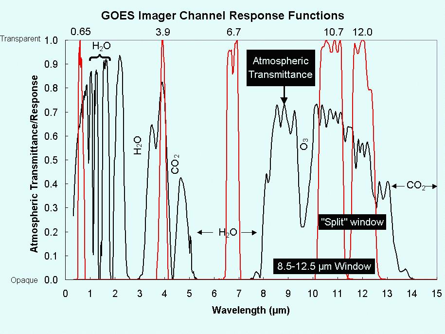
 2) infrared (~ 11 µm) and 3) water vapor (~ 6.")
6 The three most common channels on meteorological satellites are: 1) visible (~ 0.6 µm) 2) infrared (~ 11 µm) and 3) water vapor (~ 6.7 µm) channels.

7 GOES Sounder Courtesy: U. Wisconsin
8 Differing roles of GOES and NOAA polar orbiters in weather service 1. GOES is for short-range warning and nowcasting, that is, forecasting of weather in the 0-12 hr time framework (it is the range that human forecaster does a better job than computer NWP or numerical weather prediction models) 2. Polar-orbiting satellites are for longer-term forecasting. Longer-term forecasting is performed by computers through solving the evolution equations of the atmospheric motions. Polar orbiters provide the temperature/moisture profiles of the atmosphere (outside the reach of weather balloons), which are needed by the NWP models as initial conditions.
9
10 Operational Vs Experimental Operational: designed for day-to-day operations of weather services. High requirements on reliability and availability. In USA, the agency that administrates operational MetSat is NOAA (National Oceanic & Atmospheric Administration). DoD also has its own operational MetSat. Experimental: designed to test new concept or technology. May find its use in meteorological service in the future. NASA is the main space agency of this country that develops experimental satellites.
11 Experimental Meteorological Satellites/Instruments There are just too many to name. The following are worth noting: 1. ERBE (Earth Radiation Budget Experiment) 2. MODIS (Moderate-Resolution Imaging Spectroradiometer) 3. AIRS (Atmospheric Infrared Sounder) 4. TRMM (Tropical Rainfall Measuring Mission) 5. CloudSat /CALIPSO (Cloud-Aerosol Lidar & Infrared Pathfinder Satellite Observations)

12 Earth s Radiation Budget


13 Outgoing Longwave Radiation Earth Radiation Budget Satellite + π B v (T)dv = σt 4 0
 Cold Spots: Clouds")

14 Bright Spots: Clouds because they are reflective (evidence: clouds are white in visible wavelengths) Cold Spots: Clouds because they are located where temperatures are colder than the surface. Higher clouds appear colder than lower clouds

15 MODIS (Moderate-Resolution Imaging Spectroradiometer) The MODIS instrument provides high radiometric sensitivity in 36 spectral bands ranging in wavelength from 0.4 µm to 14.4 µm. Two bands are imaged at a nominal resolution of 250 m at nadir, with five bands at 500 m, and the remaining 29 bands at 1 km. Dust in the middle East A ±55-degree scanning pattern at the EOS orbit of 705 km achieves a 2,330-km swath and provides global coverage every one to two days. Courtesy: MODIS Team
 and provides more accurate information on the")
16 AIRS (Atmospheric Infrared Sounder) Like HIRS, AIRS mainly measures temperature and water vapor profiles. But with 2378 spectral channels, AIRS has a spectral resolution more than 100 times greater than previous IR sounders (such as HIRS) and provides more accurate information on the vertical profiles of atmospheric temperature and moisture. Courtesy: AIRS Team
 ; Microwave Imager; Visible/IR imager Courtesy:")
17 TRMM (Tropical Rainfall Measuring Mission) Precipitation Radar (the first spaceborne precipitation radar) ; Microwave Imager; Visible/IR imager Courtesy: TRMM Team

18 CloudSat: the first space-borne cloud radar

19 Cross section of a hurricane. Brighter colors indicate heavy precipitation.
 and precipitation (1.")
20 CloudSat Vs TRMM: differences btw cloud (3 mm) and precipitation (1.5 cm) radars
")
21 CALIPSO (Cloud-Aerosol Lidar & Infrared Pathfinder Satellite Observations) Space-borne lidar

22 CloudSat Vs CALIPSO: difference in attenuation
Lecture 4: Meteorological Satellites and Instruments. Acknowledgement: Dr. S. Kidder at Colorado State Univ.
 Lecture 4: Meteorological Satellites and Instruments Acknowledgement: Dr. S. Kidder at Colorado State Univ. Homework for the Spring Break: get some tangible, preliminary results for your final project.
Interpretation of Polar-orbiting Satellite Observations. Atmospheric Instrumentation
 Interpretation of Polar-orbiting Satellite Observations Outline Polar-Orbiting Observations: Review of Polar-Orbiting Satellite Systems Overview of Currently Active Satellites / Sensors Overview of Sensor
Meteorological Satellite Image Interpretations, Part III. Acknowledgement: Dr. S. Kidder at Colorado State Univ.
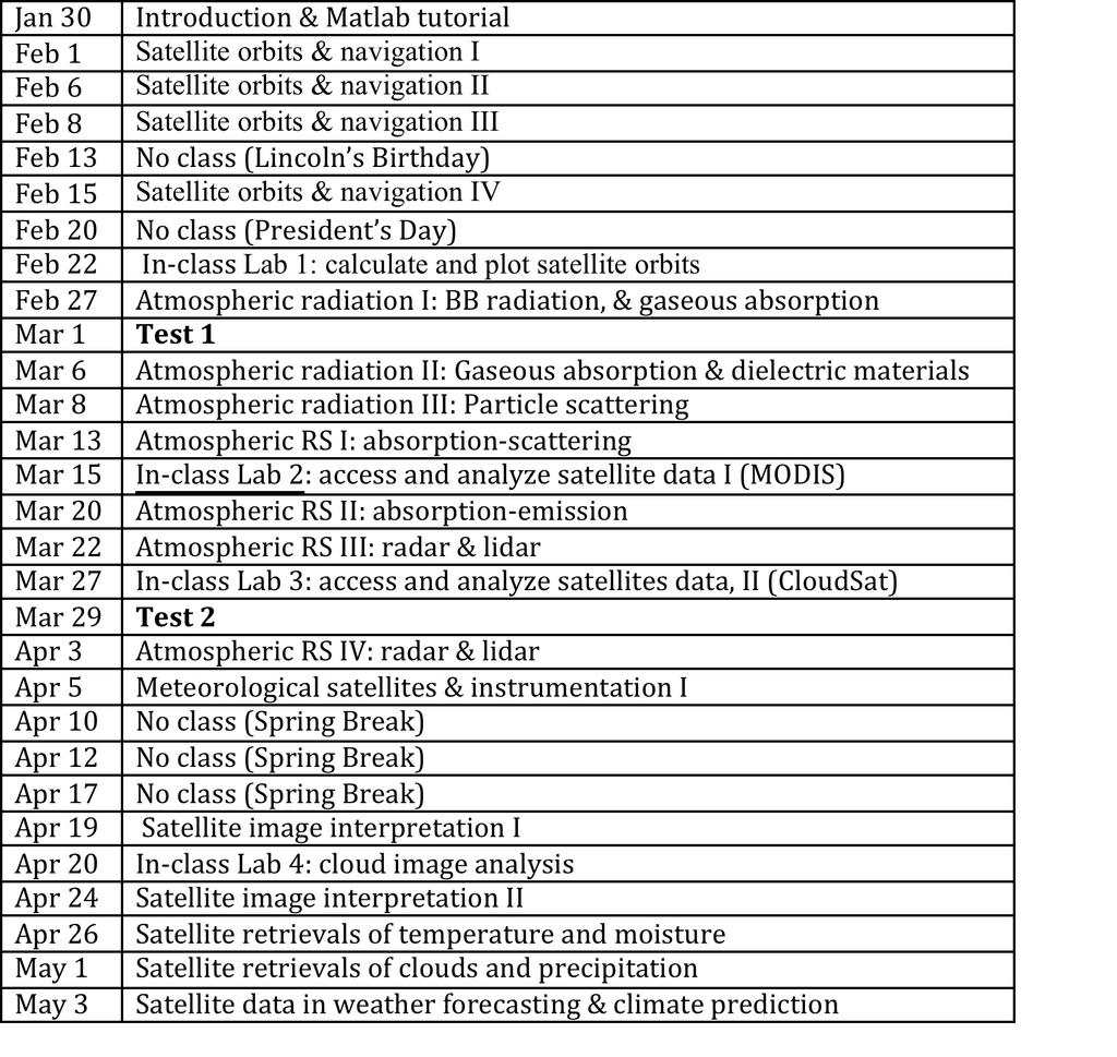
 Meteorological Satellite Image Interpretations, Part III Acknowledgement: Dr. S. Kidder at Colorado State Univ. Dates EAS417 Topics Jan 30 Introduction & Matlab tutorial Feb 1 Satellite orbits & navigation
Lecture 19: Operational Remote Sensing in Visible, IR, and Microwave Channels
 MET 4994 Remote Sensing: Radar and Satellite Meteorology MET 5994 Remote Sensing in Meteorology Lecture 19: Operational Remote Sensing in Visible, IR, and Microwave Channels Before you use data from any
Remote Sensing in Meteorology: Satellites and Radar. AT 351 Lab 10 April 2, Remote Sensing
 Remote Sensing in Meteorology: Satellites and Radar AT 351 Lab 10 April 2, 2008 Remote Sensing Remote sensing is gathering information about something without being in physical contact with it typically
TIROS-1. 1) National Aeronautics and Space Administration 2) National Oceanic and Atmospheric Administration
 National Aeronautics and Space Administration 2) National Oceanic and Atmospheric Administration") NOAA TIROS-1 NASA 1) National Aeronautics and Space Administration 2) National Oceanic and Atmospheric Administration Sputnik Sputlink Aerobee Aerobee TIROS-1 TIROS-1 1) Spiral swirl SeaWIFS Orb View2
NOAA TIROS-1 NASA 1) National Aeronautics and Space Administration 2) National Oceanic and Atmospheric Administration Sputnik Sputlink Aerobee Aerobee TIROS-1 TIROS-1 1) Spiral swirl SeaWIFS Orb View2
ATMOS 5140 Lecture 1 Chapter 1
 ATMOS 5140 Lecture 1 Chapter 1 Atmospheric Radiation Relevance for Weather and Climate Solar Radiation Thermal Infrared Radiation Global Heat Engine Components of the Earth s Energy Budget Relevance for
History of Aerosol Remote Sensing. Mark Smithgall Maria Zatko 597K Spring 2009
 History of Aerosol Remote Sensing Mark Smithgall Maria Zatko 597K Spring 2009 Aerosol Sources Anthropogenic Biological decomposition from fertilizer and sewage treatment (ex. ammonium) Combustion of fossil
Outline of 4 Lectures
 Outline of 4 Lectures 1. Sept. 17, 2008: TC best track definition and datasets, global distribution of TCs; Review of history of meteorological satellites, introducing different orbits, scanning patterns,
Sensitivity Study of the MODIS Cloud Top Property
 Sensitivity Study of the MODIS Cloud Top Property Algorithm to CO 2 Spectral Response Functions Hong Zhang a*, Richard Frey a and Paul Menzel b a Cooperative Institute for Meteorological Satellite Studies,
Lecture 1d: Satellite Orbits
 Lecture 1d: Satellite Orbits Outline 1. Newton s Laws of Motion 2. Newton s Law of Universal Gravitation 3. Kepler s Laws 4. Putting Newton and Kepler s Laws together and applying them to the Earth-satellite
REMOTE SENSING KEY!!
 REMOTE SENSING KEY!! This is a really ugly cover page I m sorry. Name Key. Score / 100 Directions: You have 50 minutes to take this test. You may use a cheatsheet (2 pages), a non-graphing calculator,
Remote Sensing of Precipitation
 Lecture Notes Prepared by Prof. J. Francis Spring 2003 Remote Sensing of Precipitation Primary reference: Chapter 9 of KVH I. Motivation -- why do we need to measure precipitation with remote sensing instruments?
REVISION OF THE STATEMENT OF GUIDANCE FOR GLOBAL NUMERICAL WEATHER PREDICTION. (Submitted by Dr. J. Eyre)
") WORLD METEOROLOGICAL ORGANIZATION Distr.: RESTRICTED CBS/OPAG-IOS (ODRRGOS-5)/Doc.5, Add.5 (11.VI.2002) COMMISSION FOR BASIC SYSTEMS OPEN PROGRAMME AREA GROUP ON INTEGRATED OBSERVING SYSTEMS ITEM: 4 EXPERT
WORLD METEOROLOGICAL ORGANIZATION Distr.: RESTRICTED CBS/OPAG-IOS (ODRRGOS-5)/Doc.5, Add.5 (11.VI.2002) COMMISSION FOR BASIC SYSTEMS OPEN PROGRAMME AREA GROUP ON INTEGRATED OBSERVING SYSTEMS ITEM: 4 EXPERT
- satellite orbits. Further Reading: Chapter 04 of the text book. Outline. - satellite sensor measurements
 (1 of 12) Further Reading: Chapter 04 of the text book Outline - satellite orbits - satellite sensor measurements - remote sensing of land, atmosphere and oceans (2 of 12) Introduction Remote Sensing:
On the Satellite Determination of Multilayered Multiphase Cloud Properties. Science Systems and Applications, Inc., Hampton, Virginia 2
 JP1.10 On the Satellite Determination of Multilayered Multiphase Cloud Properties Fu-Lung Chang 1 *, Patrick Minnis 2, Sunny Sun-Mack 1, Louis Nguyen 1, Yan Chen 2 1 Science Systems and Applications, Inc.,
VALIDATION OF INSAT-3D DERIVED RAINFALL. (Submitted by Suman Goyal, IMD) Summary and Purpose of Document
 Summary and Purpose of Document") WORLD METEOROLOGICAL ORGANIZATION COMMISSION FOR BASIC SYSTEMS OPEN PROGRAMME AREA GROUP ON INTEGRATED OBSERVING SYSTEMS INTER-PROGRAMME EXPERT TEAM ON SATELLITE UTILIZATION AND PRODUCTS SECOND SESSION
WORLD METEOROLOGICAL ORGANIZATION COMMISSION FOR BASIC SYSTEMS OPEN PROGRAMME AREA GROUP ON INTEGRATED OBSERVING SYSTEMS INTER-PROGRAMME EXPERT TEAM ON SATELLITE UTILIZATION AND PRODUCTS SECOND SESSION
Satellite observation of atmospheric dust
 Satellite observation of atmospheric dust Taichu Y. Tanaka Meteorological Research Institute, Japan Meteorological Agency 11 April 2017, SDS WAS: Dust observation and modeling @WMO, Geneva Dust observations
Applications of future GEO advanced IR sounder for high impact weather forecasting demonstration with regional OSSE
 Applications of future GEO advanced IR sounder for high impact weather forecasting demonstration with regional OSSE Jun Li @, Tim Schmit &, Zhenglong Li @, Feng Zhu @*, Pei Wang @*, Agnes Lim @, and Robert
McIDAS support of Suomi-NPP /JPSS and GOES-R L2
 McIDAS support of Suomi-NPP /JPSS and GOES-R L2 William Straka III 1 Tommy Jasmin 1, Bob Carp 1 1 Cooperative Institute for Meteorological Satellite Studies, Space Science and Engineering Center, University
APPENDIX 2 OVERVIEW OF THE GLOBAL PRECIPITATION MEASUREMENT (GPM) AND THE TROPICAL RAINFALL MEASURING MISSION (TRMM) 2-1
 AND THE TROPICAL RAINFALL MEASURING MISSION (TRMM) 2-1") APPENDIX 2 OVERVIEW OF THE GLOBAL PRECIPITATION MEASUREMENT (GPM) AND THE TROPICAL RAINFALL MEASURING MISSION (TRMM) 2-1 1. Introduction Precipitation is one of most important environmental parameters.
APPENDIX 2 OVERVIEW OF THE GLOBAL PRECIPITATION MEASUREMENT (GPM) AND THE TROPICAL RAINFALL MEASURING MISSION (TRMM) 2-1 1. Introduction Precipitation is one of most important environmental parameters.
F O U N D A T I O N A L C O U R S E
 F O U N D A T I O N A L C O U R S E December 6, 2018 Satellite Foundational Course for JPSS (SatFC-J) F O U N D A T I O N A L C O U R S E Introduction to Microwave Remote Sensing (with a focus on passive
International Cooperation in Operational Environmental Satellites: The U.S. Experience
 Committee on the Peaceful Uses of Outer Space Science and Technology Sub committee Forty seventh session February 17, 2010 Vienna, Austria International Cooperation in Operational Environmental Satellites:
Judit Kerényi. OMSZ - Hungarian Meteorological Service, Budapest, Hungary. H-1525 Budapest, P.O.Box 38, Hungary.
 SATELLITE-DERIVED PRECIPITATION ESTIMATIONS DEVELOPED BY THE HYDROLOGY SAF PROJECT CASE STUDIES FOR THE INVESTIGATION OF THEIR ACCURACY AND FEATURES IN HUNGARY Judit Kerényi OMSZ - Hungarian Meteorological
NOAA/NESDIS Tropical Web Page with LEO Satellite Products and Applications for Forecasters
 NOAA/NESDIS Tropical Web Page with LEO Satellite Products and Applications for Forecasters Sheldon Kusselson National Oceanic and Atmospheric Administration (NOAA) National Environmental Satellite Data
GEOSC/METEO 597K Kevin Bowley Kaitlin Walsh
 GEOSC/METEO 597K Kevin Bowley Kaitlin Walsh Timeline of Satellites ERS-1 (1991-2000) NSCAT (1996) Envisat (2002) RADARSAT (2007) Seasat (1978) TOPEX/Poseidon (1992-2005) QuikSCAT (1999) Jason-2 (2008)
CMA Consideration on early-morning orbit satellite
 CMA Consideration on early-morning orbit satellite National Satellite Meteorological Center,CMA Yang Jun CGMS 40 in Lugano, 5-9 Nov., 2012 Outline Background Gap analysis on the sounding data coverage
The Probabilistic Risk Assessment of the CloudSat Profiling Radar
 The Probabilistic Risk Assessment of the CloudSat Profiling Radar Todd Paulos, Alejo Engineering, Simi Valley, CA John Klohoker,,, Pasadena, CA May 2008 What is CloudSat? Launched on April 28, 2006 with
MSG system over view
 MSG system over view 1 Introduction METEOSAT SECOND GENERATION Overview 2 MSG Missions and Services 3 The SEVIRI Instrument 4 The MSG Ground Segment 5 SAF Network 6 Conclusions METEOSAT SECOND GENERATION
FUNDAMENTALS OF REMOTE SENSING FOR RISKS ASSESSMENT. 1. Introduction
 FUNDAMENTALS OF REMOTE SENSING FOR RISKS ASSESSMENT FRANÇOIS BECKER International Space University and University Louis Pasteur, Strasbourg, France; E-mail: becker@isu.isunet.edu Abstract. Remote sensing
Performance of the AIRS/AMSU And MODIS Soundings over Natal/Brazil Using Collocated Sondes: Shadoz Campaign
 Performance of the AIRS/AMSU And MODIS Soundings over Natal/Brazil Using Collocated Sondes: Shadoz Campaign 2004-2005 Rodrigo Augusto Ferreira de Souza, Jurandir Rodrigues Ventura, Juan Carlos Ceballos
Climatologies of ultra-low clouds over the southern West African monsoon region
 Climatologies of ultra-low clouds over the southern West African monsoon region Andreas H. Fink 1, R. Schuster 1, R. van der Linden 1, J. M. Schrage 2, C. K. Akpanya 2, and C. Yorke 3 1 Institute of Geophysics
Study of the Influence of Thin Cirrus Clouds on Satellite Radiances Using Raman Lidar and GOES Data
 Study of the Influence of Thin Cirrus Clouds on Satellite Radiances Using Raman Lidar and GOES Data D. N. Whiteman, D. O C. Starr, and G. Schwemmer National Aeronautics and Space Administration Goddard
Arctic Weather Every 10 Minutes: Design & Operation of ABI for PCW
 Arctic Weather Every 10 Minutes: Design and Operation of ABI for PCW Dr. Paul C. Griffith and Sue Wirth 31st Space Symposium, Technical Track, Colorado Springs, Colorado This document is not subject to
Glaciology HEAT BUDGET AND RADIATION
 HEAT BUDGET AND RADIATION A Heat Budget 1 Black body radiation Definition. A perfect black body is defined as a body that absorbs all radiation that falls on it. The intensity of radiation emitted by a
FUTURE PLAN AND RECENT ACTIVITIES FOR THE JAPANESE FOLLOW-ON GEOSTATIONARY METEOROLOGICAL SATELLITE HIMAWARI-8/9
 FUTURE PLAN AND RECENT ACTIVITIES FOR THE JAPANESE FOLLOW-ON GEOSTATIONARY METEOROLOGICAL SATELLITE HIMAWARI-8/9 Toshiyuki Kurino Japan Meteorological Agency, 1-3-4 Otemachi Chiyodaku, Tokyo 100-8122,
CNES Activity Report. Patrice Henry - CNES WGCV Plenary # 41 Tokyo Sept. 5-7, Working Group on Calibration and Validation
 Activity Report Patrice Henry - Tokyo Sept. 5-7, 2016 Working Group on Calibration and Validation SUMMARY Calibration Monitoring of in-flight Missions Preparation of future Missions Involvement in CEOS/WGCV
Unit 5 Lesson 3 How is Weather Predicted? Copyright Houghton Mifflin Harcourt Publishing Company
 Tracking the Weather Warm up 1 Why is it important to watch the weather forecast before traveling to another country? Tracking the Weather A meteorologist is a scientist who studies weather. Meteorologists
Future GOES (XGOHI, GOES-13/O/P, GOES-R+)
") Future GOES (XGOHI, GOES-13/O/P, GOES-R+) Timothy J. Schmit NOAA/NESDIS/Satellite Applications and Research Advanced Satellite Products Branch (ASPB) Madison, WI And many others MUG Meeting October 16,
Future GOES (XGOHI, GOES-13/O/P, GOES-R+) Timothy J. Schmit NOAA/NESDIS/Satellite Applications and Research Advanced Satellite Products Branch (ASPB) Madison, WI And many others MUG Meeting October 16,
Future NASA Atmospheric Missions: Adding to the A-Train Calipso OCO NPP CloudSat Glory
 Future NASA Atmospheric Missions: Adding to the A-Train James Gleason NASA Goddard Space Flight Center, Mail Code 613.3, Greenbelt, MD 20771, United States Abstract Following on the successful launch of
The Megha-Tropiques Mission
 The Megha-Tropiques Mission May 8,, 2010 0600Z courtesy www.satmos.meteo.fr Rémy Roca and the French MT science team Overview Indo-french mission realized by The Indian Space Research Organisation et the
The Transition of Atmospheric Infrared Sounder Total Ozone Products to Operations
 The Transition of Atmospheric Infrared Sounder Total Ozone Products to Operations Emily Berndt 1, Bradley Zavodsky 2, Gary Jedlovec 2 1 NASA Postdoctoral Program Marshall Space Flight Center, Huntsville,
ABB Remote Sensing Atmospheric Emitted Radiance Interferometer AERI system overview. Applications
 The ABB Atmospheric Emitted Radiance Interferometer AERI provides thermodynamic profiling, trace gas detection, atmospheric cloud aerosol study, air quality monitoring, and more. AERI high level overview
EPS-SG Candidate Observation Missions
 EPS-SG Candidate Observation Missions 3 rd Post-EPS User Consultation Workshop Peter Schlüssel Slide: 1 EPS-SG benefits to activities of NMSs Main Payload High-Resolution Infrared Sounding Microwave Sounding
Earth Exploration-Satellite Service (EESS)- Active Spaceborne Remote Sensing and Operations
- Active Spaceborne Remote Sensing and Operations") Earth Exploration-Satellite Service (EESS)- Active Spaceborne Remote Sensing and Operations SRTM Radarsat JASON Seawinds TRMM Cloudsat Bryan Huneycutt (USA) Charles Wende (USA) WMO, Geneva, Switzerland
Earth Exploration-Satellite Service (EESS)- Active Spaceborne Remote Sensing and Operations SRTM Radarsat JASON Seawinds TRMM Cloudsat Bryan Huneycutt (USA) Charles Wende (USA) WMO, Geneva, Switzerland
GEOG Lecture 8. Orbits, scale and trade-offs
 Environmental Remote Sensing GEOG 2021 Lecture 8 Orbits, scale and trade-offs Orbits revisit Orbits geostationary (36 000 km altitude) polar orbiting (200-1000 km altitude) Orbits revisit Orbits geostationary
Assimilation of Satellite Cloud and Precipitation Observations in NWP Models: Report of a Workshop
 Assimilation of Satellite Cloud and Precipitation Observations in NWP Models: Report of a Workshop George Ohring and Fuzhong Weng Joint Center for Satellite Data Assimilation Ron Errico NASA/GSFC Global
Introduction of the Hyperspectral Environmental Suite (HES) on GOES-R and beyond
 on GOES-R and beyond") Introduction of the Hyperspectral Environmental Suite (HES) on GOES-R and beyond Timothy J. Schmit SaTellite Applications and Research (STAR) Advanced Satellite Products Team (ASPT) Presented by Jun Li
Introduction of the Hyperspectral Environmental Suite (HES) on GOES-R and beyond Timothy J. Schmit SaTellite Applications and Research (STAR) Advanced Satellite Products Team (ASPT) Presented by Jun Li
GRACE Cloudsat CALIPSO Aqua. Metop TRMM TOPEX. Meteor/ SAGE GIFTS NOAA/ POES. Landsat GOES MTSAT. SeaWiFS. Aura. Terra MSG. Jason ICESat SORCE
 TRMM Metop GRACE Cloudsat CALIPSO Aqua TOPEX Meteor/ SAGE GIFTS NOAA/ POES Landsat GOES SeaWiFS MTSAT Terra Aura Jason ICESat SORCE MSG THE EARTH SYSTEM SCIENCE It is the science that studies the whole
GIFTS SOUNDING RETRIEVAL ALGORITHM DEVELOPMENT
 P2.32 GIFTS SOUNDING RETRIEVAL ALGORITHM DEVELOPMENT Jun Li, Fengying Sun, Suzanne Seemann, Elisabeth Weisz, and Hung-Lung Huang Cooperative Institute for Meteorological Satellite Studies (CIMSS) University
Title: The Impact of Convection on the Transport and Redistribution of Dust Aerosols
 Authors: Kathryn Sauter, Tristan L'Ecuyer Title: The Impact of Convection on the Transport and Redistribution of Dust Aerosols Type of Presentation: Oral Short Abstract: The distribution of mineral dust
Instrumentation planned for MetOp-SG
 Instrumentation planned for MetOp-SG Bill Bell Satellite Radiance Assimilation Group Met Office Crown copyright Met Office Outline Background - the MetOp-SG programme The MetOp-SG instruments Summary Acknowledgements:
Influence of Clouds and Aerosols on the Earth s Radiation Budget Using Clouds and the Earth s Radiant Energy System (CERES) Measurements
 Measurements") Influence of Clouds and Aerosols on the Earth s Radiation Budget Using Clouds and the Earth s Radiant Energy System (CERES) Measurements Norman G. Loeb Hampton University/NASA Langley Research Center Bruce
Influence of Clouds and Aerosols on the Earth s Radiation Budget Using Clouds and the Earth s Radiant Energy System (CERES) Measurements Norman G. Loeb Hampton University/NASA Langley Research Center Bruce
Lectures 7 and 8: 14, 16 Oct Sea Surface Temperature
 Lectures 7 and 8: 14, 16 Oct 2008 Sea Surface Temperature References: Martin, S., 2004, An Introduction to Ocean Remote Sensing, Cambridge University Press, 454 pp. Chapter 7. Robinson, I. S., 2004, Measuring
Satellites, Weather and Climate Module 1: Introduction to the Electromagnetic Spectrum
 Satellites, Weather and Climate Module 1: Introduction to the Electromagnetic Spectrum What is remote sensing? = science & art of obtaining information through data analysis, such that the device is not
Joint Polar Satellite System (JPSS)
") Joint Polar Satellite System (JPSS) United States Plans for Continuity of Operational Polar Weather and Environmental Observations Harry Cikanek, Director Mitch Goldberg, Program Scientist Joint Polar
Joint Polar Satellite System (JPSS) United States Plans for Continuity of Operational Polar Weather and Environmental Observations Harry Cikanek, Director Mitch Goldberg, Program Scientist Joint Polar
Numerical Weather Prediction in 2040
 Numerical Weather Prediction in 2040 10.8 µm GEO imagery (simulated!) Peter Bauer, ECMWF Acks.: N. Bormann, C. Cardinali, A. Geer, C. Kuehnlein, C. Lupu, T. McNally, S. English, N. Wedi will not discuss
Improving the CALIPSO VFM product with Aqua MODIS measurements
 University of Nebraska - Lincoln DigitalCommons@University of Nebraska - Lincoln NASA Publications National Aeronautics and Space Administration 2010 Improving the CALIPSO VFM product with Aqua MODIS measurements
IDEA. from research to routine
 IDEA. from research to routine A collaboration between NASA, EPA, NOAA and CIMSS Cooperative Institute for Meteorological Satellite Studies Infusing satellite Data in Environmental Applications (IDEA)
Comparison of NASA AIRS and MODIS Land Surface Temperature and Infrared Emissivity Measurements from the EOS AQUA platform
 Comparison of NASA AIRS and MODIS Land Surface Temperature and Infrared Emissivity Measurements from the EOS AQUA platform Robert Knuteson, Steve Ackerman, Hank Revercomb, Dave Tobin University of Wisconsin-Madison
Probability of Cloud-Free-Line-of-Sight (PCFLOS) Derived From CloudSat and CALIPSO Cloud Observations
 Derived From CloudSat and CALIPSO Cloud Observations") Probability of Cloud-Free-Line-of-Sight (PCFLOS) Derived From CloudSat and CALIPSO Cloud Observations Donald L. Reinke, Thomas H. Vonder Haar Cooperative Institute for Research in the Atmosphere Colorado
Probability of Cloud-Free-Line-of-Sight (PCFLOS) Derived From CloudSat and CALIPSO Cloud Observations Donald L. Reinke, Thomas H. Vonder Haar Cooperative Institute for Research in the Atmosphere Colorado
EUMETSAT products and services for monitoring storms - New missions, more data and more meteorological products
 EUMETSAT products and services for monitoring storms - New missions, more data and more meteorological products Jochen Grandell 1 EUM/RSP/VWG/17/921460 Outline Overview of EUMETSAT missions Current...and
A MEDIUM EARTH ORBIT CONTELLATION FOR POLAR WIND MEASUREMENTS
 A MEDIUM EARTH ORBIT CONTELLATION FOR POLAR WIND MEASUREMENTS Gerald J. Dittberner 1, Shyam N. Bajpai 1, Andrew J. Gerber, jr. 2, Richard Baron 2, Francois Rogez 2 1 U.S. National Oceanic and Atmospheric
Remote Sensing I: Basics
 Remote Sensing I: Basics Kelly M. Brunt Earth System Science Interdisciplinary Center, University of Maryland Cryospheric Science Laboratory, Goddard Space Flight Center kelly.m.brunt@nasa.gov (Based on
Variability in Global Top-of-Atmosphere Shortwave Radiation Between 2000 And 2005
 Variability in Global Top-of-Atmosphere Shortwave Radiation Between 2000 And 2005 Norman G. Loeb NASA Langley Research Center Hampton, VA Collaborators: B.A. Wielicki, F.G. Rose, D.R. Doelling February
Status of Indian Satellite Meteorological Programme
 Status of Indian Satellite Meteorological Programme Pradeep K Thapliyal Space Applications Centre (SAC) Indian Space research Organisation (ISRO) Ahmedabad (INDIA) Email: pkthapliyal@sac.isro.gov.in International
Atmospheric Profiles Over Land and Ocean from AMSU
 P1.18 Atmospheric Profiles Over Land and Ocean from AMSU John M. Forsythe, Kevin M. Donofrio, Ron W. Kessler, Andrew S. Jones, Cynthia L. Combs, Phil Shott and Thomas H. Vonder Haar DoD Center for Geosciences
Report on CIMSS Participation in the Utility of GOES-R Instruments for Hurricane Data Assimilation and Forecasting
 Report on CIMSS Participation in the Utility of GOES-R Instruments for Hurricane Data Assimilation and Forecasting Award Number: NA10NES4400010 Award Period: 06/01/2010-05/31/2014 Program Office: NESDIS
Feature-tracked 3D Winds from Satellite Sounders: Derivation and Impact in Global Models
 Feature-tracked 3D Winds from Satellite Sounders: Derivation and Impact in Global Models David Santek 1, A.-S. Daloz 1, S. Tushaus 1, M. Rogal 1, W. McCarty 2 1 Space Science and Engineering Center/University
The HIRS outgoing longwave radiation product from hybrid polar and geosynchronous satellite observations
 Advances in Space Research 33 (2004) 1120 1124 www.elsevier.com/locate/asr The HIRS outgoing longwave radiation product from hybrid polar and geosynchronous satellite observations Hai-Tien Lee a, *, Andrew
Module 11: Meteorology Topic 5 Content: Weather Maps Notes
 Introduction A variety of weather maps are produced by the National Weather Service and National Oceanographic Atmospheric Administration. These maps are used to help meteorologists accurately predict
Moisture, Clouds, and Precipitation: Clouds and Precipitation. Dr. Michael J Passow
 Moisture, Clouds, and Precipitation: Clouds and Precipitation Dr. Michael J Passow What Processes Lift Air? Clouds require three things: water vapor, a condensation nucleus, and cooling Cooling usually
Detection of convective overshooting tops using Himawari-8 AHI, CloudSat CPR, and CALIPSO data
 Detection of convective overshooting tops using Himawari-8 AHI, CloudSat CPR, and CALIPSO data Miae Kim¹, Jungho Im¹, Seonyoung Park¹ ¹Ulsan National Institute of Science and Technology (UNIST), South
Projects in the Remote Sensing of Aerosols with focus on Air Quality
 Projects in the Remote Sensing of Aerosols with focus on Air Quality Faculty Leads Barry Gross (Satellite Remote Sensing), Fred Moshary (Lidar) Direct Supervision Post-Doc Yonghua Wu (Lidar) PhD Student
Lecture 4: Radiation Transfer
 Lecture 4: Radiation Transfer Spectrum of radiation Stefan-Boltzmann law Selective absorption and emission Reflection and scattering Remote sensing Importance of Radiation Transfer Virtually all the exchange
Introduction of the Hyperspectral Environmental Suite (HES) on GOES-R and beyond
 on GOES-R and beyond") Introduction of the Hyperspectral Environmental Suite (HES) on GOES-R and beyond 1 Timothy J. Schmit, 2 Jun Li, 3 James Gurka 1 NOAA/NESDIS, Office of Research and Applications, Advanced Satellite Products
Introduction of the Hyperspectral Environmental Suite (HES) on GOES-R and beyond 1 Timothy J. Schmit, 2 Jun Li, 3 James Gurka 1 NOAA/NESDIS, Office of Research and Applications, Advanced Satellite Products
MODULE 2 LECTURE NOTES 1 SATELLITES AND ORBITS
 MODULE 2 LECTURE NOTES 1 SATELLITES AND ORBITS 1. Introduction When a satellite is launched into the space, it moves in a well defined path around the Earth, which is called the orbit of the satellite.
The Use of Hyperspectral Infrared Radiances In Numerical Weather Prediction
 The Use of Hyperspectral Infrared Radiances In Numerical Weather Prediction J. Le Marshall 1, J. Jung 1, J. Derber 1, T. Zapotocny 2, W. L. Smith 3, D. Zhou 4, R. Treadon 1, S. Lord 1, M. Goldberg 1 and
NESDIS Polar (Region) Products and Plans. Jeff Key NOAA/NESDIS Madison, Wisconsin USA
 Products and Plans. Jeff Key NOAA/NESDIS Madison, Wisconsin USA") NESDIS Polar (Region) Products and Plans Jeff Key NOAA/NESDIS Madison, Wisconsin USA WMO Polar Space Task Group, 2 nd meeting, Geneva, 12 14 June 2012 Relevant Missions and Products GOES R ABI Fractional
NESDIS Polar (Region) Products and Plans Jeff Key NOAA/NESDIS Madison, Wisconsin USA WMO Polar Space Task Group, 2 nd meeting, Geneva, 12 14 June 2012 Relevant Missions and Products GOES R ABI Fractional
Remote Sensing Observations AOSC 200 Tim Canty
 Remote Sensing Observations AOSC 200 Tim Canty Class Web Site: http://www.atmos.umd.edu/~tcanty/aosc200 Topics for today: Maps Radar Satellite Observations Lecture 04 Feb 7 2019 1 Today s Weather Map http://www.wpc.ncep.noaa.gov/sfc/namussfcwbg.gif
Methane Sensing Flight of Scanning HIS over Hutchinson, KS, 31 March 2001
 Methane Sensing Flight of Scanning HIS over Hutchinson, KS, 31 March 2001 Hank Revercomb, Chris Moeller, Bob Knuteson, Dave Tobin, Ben Howell University of Wisconsin, Space Science and Engineering Center
1.0 Introduction 1.1 The Earth Radiation Budget
 1.0 Introduction 1.1 The Earth Radiation Budget The ability of man to influence his surroundings on a global scale is a phenomenon unique to the twentieth century. With the advent of industrialization
The EarthCARE mission: An active view on aerosols, clouds and radiation
 The EarthCARE mission: An active view on aerosols, clouds and radiation T. Wehr, P. Ingmann, T. Fehr Heraklion, Crete, Greece 08/06/2015 EarthCARE is ESA s sixths Earth Explorer Mission and will be implemented
THE FEASIBILITY OF EXTRACTING LOWLEVEL WIND BY TRACING LOW LEVEL MOISTURE OBSERVED IN IR IMAGERY OVER CLOUD FREE OCEAN AREA IN THE TROPICS
 THE FEASIBILITY OF EXTRACTING LOWLEVEL WIND BY TRACING LOW LEVEL MOISTURE OBSERVED IN IR IMAGERY OVER CLOUD FREE OCEAN AREA IN THE TROPICS Toshiro Ihoue and Tetsuo Nakazawa Meteorological Research Institute
Maps and Remote Sensing AOSC 200 Tim Canty
 Maps and Remote Sensing AOSC 200 Tim Canty Class Web Site: http://www.atmos.umd.edu/~tcanty/aosc200 Topics for today: Weather Maps Radar Satellite Observations Lecture 04 Feb 7 2019 1 Today s Weather Map
EXPERIMENTAL ASSIMILATION OF SPACE-BORNE CLOUD RADAR AND LIDAR OBSERVATIONS AT ECMWF
 EXPERIMENTAL ASSIMILATION OF SPACE-BORNE CLOUD RADAR AND LIDAR OBSERVATIONS AT ECMWF Marta Janisková, Sabatino Di Michele, Edouard Martins ECMWF, Shinfield Park, Reading, U.K. Abstract Space-borne active
P3.24 EVALUATION OF MODERATE-RESOLUTION IMAGING SPECTRORADIOMETER (MODIS) SHORTWAVE INFRARED BANDS FOR OPTIMUM NIGHTTIME FOG DETECTION
 SHORTWAVE INFRARED BANDS FOR OPTIMUM NIGHTTIME FOG DETECTION") P3.24 EVALUATION OF MODERATE-RESOLUTION IMAGING SPECTRORADIOMETER (MODIS) SHORTWAVE INFRARED BANDS FOR OPTIMUM NIGHTTIME FOG DETECTION 1. INTRODUCTION Gary P. Ellrod * NOAA/NESDIS/ORA Camp Springs, MD
P3.24 EVALUATION OF MODERATE-RESOLUTION IMAGING SPECTRORADIOMETER (MODIS) SHORTWAVE INFRARED BANDS FOR OPTIMUM NIGHTTIME FOG DETECTION 1. INTRODUCTION Gary P. Ellrod * NOAA/NESDIS/ORA Camp Springs, MD
Back to basics: From Sputnik to Envisat, and beyond: The use of satellite measurements in weather forecasting and research: Part 1 A history
 Back to basics: From Sputnik to Envisat, and beyond: The use of satellite measurements in weather forecasting and research: Part 1 A history Roger Brugge 1 and Matthew Stuttard 2 1 NERC Data Assimilation
CloudSat adding new insight into tropical penetrating convection
 Click Here for Full Article GEOPHYSICAL RESEARCH LETTERS, VOL. 35, L19819, doi:10.1029/2008gl035330, 2008 CloudSat adding new insight into tropical penetrating convection Zhengzhao Luo, 1 Guangyuan Y.
Course outline, objectives, workload, projects, expectations
 Course outline, objectives, workload, projects, expectations Introductions Remote Sensing Overview Elements of a remote sensing observing system 1. platform (satellite, surface, etc) 2. experimental design
The Status Report of FY-2F
 Seventh Session of the Expert Team on Satellite Utilization and Products The Status Report of FY-2F Presented by Xiang Fang National Satellite Meteorological Center (NSMC) China Meteorological Administration
URSI-F Microwave Signatures Meeting 2010, Florence, Italy, October 4 8, Thomas Meissner Lucrezia Ricciardulli Frank Wentz
 URSI-F Microwave Signatures Meeting 2010, Florence, Italy, October 4 8, 2010 Wind Measurements from Active and Passive Microwave Sensors High Winds and Winds in Rain Thomas Meissner Lucrezia Ricciardulli
Microwave-TC intensity estimation. Ryo Oyama Meteorological Research Institute Japan Meteorological Agency
 Microwave-TC intensity estimation Ryo Oyama Meteorological Research Institute Japan Meteorological Agency Contents 1. Introduction 2. Estimation of TC Maximum Sustained Wind (MSW) using TRMM Microwave
The current status of FY-3D
 The current status of FY-3D Xiang Fang National Satellite Meteorological Center, China Meteorological Administration (NSMC/CMA) OUTLINE Overview Key instruments onboard FY-3D Products and data service
STATUS OF JAPANESE METEOROLOGICAL SATELLITES AND RECENT ACTIVITIES OF MSC
 STATUS OF JAPANESE METEOROLOGICAL SATELLITES AND RECENT ACTIVITIES OF MSC Daisaku Uesawa Meteorological Satellite Center, Japan Meteorological Agency Abstract MTSAT-1R is the current operational Japanese
Current capabilities and limitations of satellite monitoring and modeling forecasting of volcanic clouds: and example of Eyjafjallaj
 Current capabilities and limitations of satellite monitoring and modeling forecasting of volcanic clouds: and example of Eyjafjallaj fjallajökull eruption (pronounced EYE-a-fyat fyat-la-jo-kotl) N. Krotkov
Satellite Oceanography and Applications 1: Introduction, SST, Ocean color
 Satellite Oceanography and Applications 1: Introduction, SST, Ocean color Ebenezer Nyadjro US Naval Research Lab RMU Summer Program (AUGUST 24-28, 2015) Objectives/Goals To know the basic methods of ocean
International TOVS Study Conference-XV Proceedings
 Relative Information Content of the Advanced Technology Microwave Sounder, the Advanced Microwave Sounding Unit and the Microwave Humidity Sounder Suite Motivation Thomas J. Kleespies National Oceanic
Operational systems for SST products. Prof. Chris Merchant University of Reading UK
 Operational systems for SST products Prof. Chris Merchant University of Reading UK Classic Images from ATSR The Gulf Stream ATSR-2 Image, ƛ = 3.7µm Review the steps to get SST using a physical retrieval
Preparation for FY-4A. (Submitted by Xiang Fang, CMA)
") WORLD METEOROLOGICAL ORGANIZATION COMMISSION FOR BASIC SYSTEMS OPEN PROGRAMME AREA GROUP ON INTEGRATED OBSERVING SYSTEMS EXPERT TEAM ON SATELLITE UTILIZATION AND PRODUCTS ET-SUP-8/Doc. 10.3 (2.IV.2014)
WORLD METEOROLOGICAL ORGANIZATION COMMISSION FOR BASIC SYSTEMS OPEN PROGRAMME AREA GROUP ON INTEGRATED OBSERVING SYSTEMS EXPERT TEAM ON SATELLITE UTILIZATION AND PRODUCTS ET-SUP-8/Doc. 10.3 (2.IV.2014)