GEOG Lecture 8. Orbits, scale and trade-offs
|
|
|
- Johnathan Haynes
- 6 years ago
- Views:
Transcription
1 Environmental Remote Sensing GEOG 2021 Lecture 8 Orbits, scale and trade-offs
2
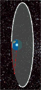
3 Orbits revisit Orbits geostationary ( km altitude) polar orbiting ( km altitude)
4 Orbits revisit Orbits geostationary ( km altitude) polar orbiting ( km altitude)
 orbits per day Majority of RS instruments e.g. MODIS, AVHRR, Landsat, SPOT, Ikonos etc.")
5 Orbits: trade-offs / pros and cons Polar orbiting Polar (or near-polar) orbit inclined to equator Typical altitude km, orbital period ~100 mins so multiple (15-20) orbits per day Majority of RS instruments e.g. MODIS, AVHRR, Landsat, SPOT, Ikonos etc.
6 Orbits and trade-offs: polar
7 Orbits and trade-offs: polar Advantages Higher spatial resolution (<m to few km), depending on instrument and swath width Global coverage due to combination of orbit path and rotation of Earth Disadvantages Takes time to come back to point on surface e g 1 or 2 Takes time to come back to point on surface e.g. 1 or 2 days for MODIS, 16 days for Landsat
8 Orbits and trade-offs: polar
9 Orbits and trade-offs: polar Ortib Track (e.g. Terra) Live: Static: EarthNow! Landsat Image Viewer
 of 24 hours Always in same place over surface MUCH further away then polar ~36,000km")
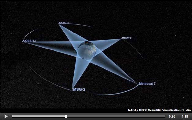
10 Orbits: trade-offs / pros and cons Geostationary Orbit over equator, with orbit period (by definition) of 24 hours Always in same place over surface MUCH further away then polar ~36,000km altitude


11 Orbits and trade-offs: Geostationary
12 Orbits and trade-offs: Geostationary
13 Orbits and trade-offs: Geostationary Advantages Always look at same part of Earth Rapid repeat time (as fast as you like) e.g. Meteosat every 15 minutes - ideal for weather monitoring/forecasting Disadvantages Much higher (36000km) altitude means lower resolution Not global coverage See same side of Earth High-latitude
14 Orbits and trade-offs: Geostationary METEOSAT 2 nd Gen (MSG) (geostationary orbit) 1km (equator) to 3km (worse with latitude) Views of whole Earth disk every 15 mins 30+ years METEOSAT data MSG-2 image of Northern Europe Mostly cloud free
15 Remember, we always have trade-offs in space, time, wavelength etc. determined by application Global coverage means broad swaths, moderate-to-low resolution Accept low spatial detail for global coverage & rapid revisit times Land cover change, deforestation, vegetation dynamics, surface reflectance, ocean and atmospheric circulation, global l carbon & hydrological cycle E.g. MODIS, MERIS
16 Remember, we always have trade-offs in space, time, wavelength etc. determined by application Global coverage means broad swaths, moderate-to-low resolution MODIS (Terra, Aqua) (near-polar orbit) 250m to 1km, 7 bands across visible + NIR, swath width ~2400 km, repeat 1-2 days MERIS (near-polar orbit) ~300m, 15 bands across visible + NIR, swath width ~1100 km, repeat time hours to days SeaWiFS (Sea-Viewing Wide Field-of-View Sensor) 1km resolution, 2800km swath, 16 day repeat Designed for ocean colour studies
17 Remember trade-offs in space, time, wavelength etc. SeaWiFS (Sea-Viewing i Wide Field-of-View Sensor) Designed for ocean colour studies 1km resolution, 2800km swath, 16 day repeat


 Designed for")

18 Remember trade-offs in space, time, wavelength etc. SeaWiFS (Sea-Viewing i Wide Field-of-View Sensor) Designed for ocean colour studies 1km resolution, 2800km swath, 16 day repeat


19 htt // l f sa.gov/cgi/browse.pl SeaWiFS MODIS MERIS
20 Combined Chlorophyll (Ocean Colour) Combined SeaWiFS, MODIS, MERIS Dec 31, 2002
21 Remember trade-offs in space, time, wavelength etc. MERIS image of Californian MERIS image of Californian fires, October 2007
22 Remember trade-offs in space, time, wavelength etc. Local to regional Requires much higher spatial resolution (< 100m) So typically, narrower swaths (10s to 100s km) and longer repeat times (weeks to months) E.g. LandSat (polar orbit) 28m spatial, 7 bands, swath ~185km, repeat time nominally 16 days BUT optical, so clouds can be big problem E.g. IKONOS (polar orbit) 0.5m spatial, 4 bands, swath only 11 km, so requires dedicated targeting
23 Remember trade-offs in space, time, wavelength etc. SPOT 1-4 Relatively high resolution instrument, like Landsat 20m spatial, 60km swath, 26 day repeat IKONOS QuickBird IKONOS, QuickBird Very high resolution (<1m), narrow swath (10-15km) Limited bands, on-demand acquisition
24 A changing world: Earth Palm Jumeirah, UAE Images courtesy GeoEYE/SIME


25 RADAR revisit What does RADAR backscatter measure? Why speckles? E.g. ERS-SARSAR operates in C band, detects changes in surface heights near-polar polar, orbit100 min, repeat 35 days, swath 100km
26 RADAR Parameters affecting radar backscatter? Influence of frequency, polarization, roughness, incidence angle, and moistures Advantages All-weather Day and night Readings: // / / /S OCS/ / C / dar_course_iii/parameters_affecting.htm


27 Missing Malaysian plane? Also check out DigitalGlobe s Campaign:
28 Summary Instrument characteristics determined by application How often do we need data, at what spatial and spectral resolution? Can we combine observations?? E.g. optical AND microwave? LIDAR? Polar and geostationary orbits? Constellations?
Remote Sensing I: Basics
 Remote Sensing I: Basics Kelly M. Brunt Earth System Science Interdisciplinary Center, University of Maryland Cryospheric Science Laboratory, Goddard Space Flight Center kelly.m.brunt@nasa.gov (Based on
- satellite orbits. Further Reading: Chapter 04 of the text book. Outline. - satellite sensor measurements
 (1 of 12) Further Reading: Chapter 04 of the text book Outline - satellite orbits - satellite sensor measurements - remote sensing of land, atmosphere and oceans (2 of 12) Introduction Remote Sensing:
MODULE 2 LECTURE NOTES 1 SATELLITES AND ORBITS
 MODULE 2 LECTURE NOTES 1 SATELLITES AND ORBITS 1. Introduction When a satellite is launched into the space, it moves in a well defined path around the Earth, which is called the orbit of the satellite.
Lecture 4b: Meteorological Satellites and Instruments. Acknowledgement: Dr. S. Kidder at Colorado State Univ.
 Lecture 4b: Meteorological Satellites and Instruments Acknowledgement: Dr. S. Kidder at Colorado State Univ. US Geostationary satellites - GOES (Geostationary Operational Environmental Satellites) US
REVISION OF THE STATEMENT OF GUIDANCE FOR GLOBAL NUMERICAL WEATHER PREDICTION. (Submitted by Dr. J. Eyre)
") WORLD METEOROLOGICAL ORGANIZATION Distr.: RESTRICTED CBS/OPAG-IOS (ODRRGOS-5)/Doc.5, Add.5 (11.VI.2002) COMMISSION FOR BASIC SYSTEMS OPEN PROGRAMME AREA GROUP ON INTEGRATED OBSERVING SYSTEMS ITEM: 4 EXPERT
WORLD METEOROLOGICAL ORGANIZATION Distr.: RESTRICTED CBS/OPAG-IOS (ODRRGOS-5)/Doc.5, Add.5 (11.VI.2002) COMMISSION FOR BASIC SYSTEMS OPEN PROGRAMME AREA GROUP ON INTEGRATED OBSERVING SYSTEMS ITEM: 4 EXPERT
Remote Sensing of Snow GEOG 454 / 654
 Remote Sensing of Snow GEOG 454 / 654 What crysopheric questions can RS help to answer? 2 o Where is snow lying? (Snow-covered area or extent) o How much is there? o How rapidly is it melting? (Area, depth,
GEOSC/METEO 597K Kevin Bowley Kaitlin Walsh
 GEOSC/METEO 597K Kevin Bowley Kaitlin Walsh Timeline of Satellites ERS-1 (1991-2000) NSCAT (1996) Envisat (2002) RADARSAT (2007) Seasat (1978) TOPEX/Poseidon (1992-2005) QuikSCAT (1999) Jason-2 (2008)
Principles of Satellite Remote Sensing
 Chapter 5 Principles of Satellite Remote Sensing Goal: Give a overview on the characteristics of satellite remote sensing. Satellites have several unique characteristics which make them particularly useful
Challenges for the operational assimilation of satellite image data in agrometeorological models
 Challenges for the operational assimilation of satellite image data in agrometeorological models Mark Danson Centre for Environmental Systems Research, University of Salford, UK 0 Objectives The main objective
Lesson 4b Remote Sensing and geospatial analysis to integrate observations over larger scales
 Lesson 4b Remote Sensing and geospatial analysis to integrate observations over larger scales We have discussed static sensors, human-based (participatory) sensing, and mobile sensing Remote sensing: Satellite
Environmental Remote Sensing GEOG 2021
 Environmental Remote Sensing GEOG 2021 Lecture 3 Spectral information in remote sensing Spectral Information 2 Outline Mechanisms of variations in reflectance Optical Microwave Visualisation/analysis Enhancements/transforms
In-flight Calibration Techniques Using Natural Targets. CNES Activities on Calibration of Space Sensors
 In-flight Calibration Techniques Using Natural Targets CNES Activities on Calibration of Space Sensors Bertrand Fougnie, Patrice Henry (DCT/SI, CNES, Toulouse, France) In-flight Calibration using Natural
Satellites, Weather and Climate Module 1: Introduction to the Electromagnetic Spectrum
 Satellites, Weather and Climate Module 1: Introduction to the Electromagnetic Spectrum What is remote sensing? = science & art of obtaining information through data analysis, such that the device is not
A HIGH RESOLUTION EUROPEAN CLOUD CLIMATOLOGY FROM 15 YEARS OF NOAA/AVHRR DATA
 A HIGH RESOLUTION EUROPEAN CLOUD CLIMATOLOGY FROM 15 YEARS OF NOAA/AVHRR DATA R. Meerkötter 1, G. Gesell 2, V. Grewe 1, C. König 1, S. Lohmann 1, H. Mannstein 1 Deutsches Zentrum für Luft- und Raumfahrt
The VENμS mission: Earth Observation with High Spatial and Temporal Resolution Capabilities
 Ben Gurion University The VENμS mission: Earth Observation with High Spatial and Temporal Resolution Capabilities G. Dedieu 1, O. Hagolle 2, A. Karnieli 3, S. Cherchali 2 P. Ferrier 2 and Y. Yaniv 4 1
A MEDIUM EARTH ORBIT CONTELLATION FOR POLAR WIND MEASUREMENTS
 A MEDIUM EARTH ORBIT CONTELLATION FOR POLAR WIND MEASUREMENTS Gerald J. Dittberner 1, Shyam N. Bajpai 1, Andrew J. Gerber, jr. 2, Richard Baron 2, Francois Rogez 2 1 U.S. National Oceanic and Atmospheric
Interpretation of Polar-orbiting Satellite Observations. Atmospheric Instrumentation
 Interpretation of Polar-orbiting Satellite Observations Outline Polar-Orbiting Observations: Review of Polar-Orbiting Satellite Systems Overview of Currently Active Satellites / Sensors Overview of Sensor
FUNDAMENTALS OF REMOTE SENSING FOR RISKS ASSESSMENT. 1. Introduction
 FUNDAMENTALS OF REMOTE SENSING FOR RISKS ASSESSMENT FRANÇOIS BECKER International Space University and University Louis Pasteur, Strasbourg, France; E-mail: becker@isu.isunet.edu Abstract. Remote sensing
Remote sensing of sea ice
 Remote sensing of sea ice Ice concentration/extent Age/type Drift Melting Thickness Christian Haas Remote Sensing Methods Passive: senses shortwave (visible), thermal (infrared) or microwave radiation
Recent Update on MODIS C6 and VIIRS Deep Blue Aerosol Products
 Recent Update on MODIS C6 and VIIRS Deep Blue Aerosol Products N. Christina Hsu, Photo taken from Space Shuttle: Fierce dust front over Libya Corey Bettenhausen, Andrew M. Sayer, and Rick Hansell Laboratory
GMES: calibration of remote sensing datasets
 GMES: calibration of remote sensing datasets Jeremy Morley Dept. Geomatic Engineering jmorley@ge.ucl.ac.uk December 2006 Outline Role of calibration & validation in remote sensing Types of calibration
Satellite observation of atmospheric dust
 Satellite observation of atmospheric dust Taichu Y. Tanaka Meteorological Research Institute, Japan Meteorological Agency 11 April 2017, SDS WAS: Dust observation and modeling @WMO, Geneva Dust observations
Back to basics: From Sputnik to Envisat, and beyond: The use of satellite measurements in weather forecasting and research: Part 1 A history
 Back to basics: From Sputnik to Envisat, and beyond: The use of satellite measurements in weather forecasting and research: Part 1 A history Roger Brugge 1 and Matthew Stuttard 2 1 NERC Data Assimilation
CGMS Baseline. Sustained contributions to the Global Observing System. Endorsed by CGMS-46 in Bengaluru, June 2018
 CGMS Baseline Sustained contributions to the Global Observing System Best Practices for Achieving User Readiness for New Meteorological Satellites Endorsed by CGMS-46 in Bengaluru, June 2018 CGMS/DOC/18/1028862,
Atmospheric correction in presence of sun glint: the POLYMER Algorithm
 Atmospheric correction in presence of sun glint: the POLYMER Algorithm Dominique Jolivet François Steinmetz Pierre-Yves Deschamps Jan 17, 2011 Atelier National Couleur de l'eau - GIS COOC c 2011 Atmospheric
Remote Sensing in Meteorology: Satellites and Radar. AT 351 Lab 10 April 2, Remote Sensing
 Remote Sensing in Meteorology: Satellites and Radar AT 351 Lab 10 April 2, 2008 Remote Sensing Remote sensing is gathering information about something without being in physical contact with it typically
ESM 186 Environmental Remote Sensing and ESM 186 Lab Syllabus Winter 2012
 ESM 186 Environmental Remote Sensing and ESM 186 Lab Syllabus Winter 2012 Instructor: Susan Ustin (slustin@ucdavis.edu) Phone: 752-0621 Office: 233 Veihmeyer Hall and 115A, the Barn Office Hours: Tuesday
Operational ice charting in mid-latitudes using Near-Real-Time SAR imagery
 Operational ice charting in mid-latitudes using Near-Real-Time SAR imagery Sergey Vernyayev Ice Engineer ICEMAN.KZ Carles Debart Project Manager Energy, Environment and Security Yevgeniy Kadranov Ice charting
Examination Questions & Model Answers (2009/2010) PLEASE PREPARE YOUR QUESTIONS AND ANSWERS BY USING THE FOLLOWING GUIDELINES;
 PLEASE PREPARE YOUR QUESTIONS AND ANSWERS BY USING THE FOLLOWING GUIDELINES;") Examination s & Model Answers (2009/2010) PLEASE PREPARE YOUR QUESTIONS AND ANSWERS BY USING THE FOLLOWING GUIDELINES; 1. If using option 2 or 3 use template provided 2. Use Times New Roman 12 3. Enter
Examination s & Model Answers (2009/2010) PLEASE PREPARE YOUR QUESTIONS AND ANSWERS BY USING THE FOLLOWING GUIDELINES; 1. If using option 2 or 3 use template provided 2. Use Times New Roman 12 3. Enter
sentinel-2 COLOUR VISION FOR COPERNICUS
 sentinel-2 COLOUR VISION FOR COPERNICUS SATELLITES TO SERVE By providing a set of key information services for a wide range of practical applications, Europe s Copernicus programme is providing a step
OCEAN SURFACE DRIFT BY WAVELET TRACKING USING ERS-2 AND ENVISAT SAR IMAGES
 OCEAN SURFACE DRIFT BY WAVELET TRACKING USING ERS-2 AND ENVISAT SAR IMAGES Antony K. Liu, Yunhe Zhao Ocean Sciences Branch, NASA Goddard Space Flight Center, Greenbelt, Maryland, USA Ming-Kuang Hsu Northern
Satellite Oceanography and Applications 1: Introduction, SST, Ocean color
 Satellite Oceanography and Applications 1: Introduction, SST, Ocean color Ebenezer Nyadjro US Naval Research Lab RMU Summer Program (AUGUST 24-28, 2015) Objectives/Goals To know the basic methods of ocean
Towards eenvironment Prague, March GMES Space Component. Josef Aschbacher Head, ESA GMES Space Office
 Towards eenvironment Prague, 25-27 March 2009 GMES Space Component Josef Aschbacher Head, ESA GMES Space Office Prague from Space Segment 2 05 Nov 2003 CNES 2003 GISAT 2007 ESA GSELAND GMES is an EU led
Lecture 19: Operational Remote Sensing in Visible, IR, and Microwave Channels
 MET 4994 Remote Sensing: Radar and Satellite Meteorology MET 5994 Remote Sensing in Meteorology Lecture 19: Operational Remote Sensing in Visible, IR, and Microwave Channels Before you use data from any
sentinel-3 A BIGGER PICTURE FOR COPERNICUS
 sentinel-3 A BIGGER PICTURE FOR COPERNICUS SATELLITES TO SERVE By providing a set of key information services for a wide range of practical applications, Europe s Copernicus programme has been put in place
OSSE to infer the impact of Arctic AMVs extracted from highly elliptical orbit imagery
 OSSE to infer the impact of Arctic AMVs extracted from highly elliptical orbit imagery L. Garand 1 Y. Rochon 1, S. Heilliette 1, J. Feng 1, A.P. Trishchenko 2 1 Environment Canada, 2 Canada Center for
EUMETSAT products and services for monitoring storms - New missions, more data and more meteorological products
 EUMETSAT products and services for monitoring storms - New missions, more data and more meteorological products Jochen Grandell 1 EUM/RSP/VWG/17/921460 Outline Overview of EUMETSAT missions Current...and
OCEAN COLOUR MONITOR ON-BOARD OCEANSAT-2
 OCEAN COLOUR MONITOR ON-BOARD OCEANSAT-2 Rangnath R Navalgund Space Applications Centre Indian Space Research Organisation Ahmedabad-380015, INDIA OCEANSAT-2 2 MISSION OCEANSAT-2 2 is a global mission
SAN FRANCISCO STATE UNIVERSITY NAME DEPARTMENT OF GEOSCIENCES Spring 2013
 SAN FRANCISCO STATE UNIVERSITY NAME DEPARTMENT OF GEOSCIENCES Spring 2013 METR 415/715: MONTEVERDI QUIZ 1 Open Book and Open Notes 200 points, 45 minutes 1. Compute the altitude of a geostationary orbit
Aerosol Retrieved from MODIS: Algorithm, Products, Validation and the Future
 Aerosol Retrieved from MODIS: Algorithm, Products, Validation and the Future Presented by: Rob Levy Re-presenting NASA-GSFC s MODIS aerosol team: Y. Kaufman, L. Remer, A. Chu,, C. Ichoku,, R. Kleidman,,
Nerushev A.F., Barkhatov A.E. Research and Production Association "Typhoon" 4 Pobedy Street, , Obninsk, Kaluga Region, Russia.
 DETERMINATION OF ATMOSPHERIC CHARACTERISTICS IN THE ZONE OF ACTION OF EXTRA-TROPICAL CYCLONE XYNTHIA (FEBRUARY 2010) INFERRED FROM SATELLITE MEASUREMENT DATA Nerushev A.F., Barkhatov A.E. Research and
Land Surface Temperature Measurements From the Split Window Channels of the NOAA 7 Advanced Very High Resolution Radiometer John C.
 Land Surface Temperature Measurements From the Split Window Channels of the NOAA 7 Advanced Very High Resolution Radiometer John C. Price Published in the Journal of Geophysical Research, 1984 Presented
THE LAND-SAF SURFACE ALBEDO AND DOWNWELLING SHORTWAVE RADIATION FLUX PRODUCTS
 THE LAND-SAF SURFACE ALBEDO AND DOWNWELLING SHORTWAVE RADIATION FLUX PRODUCTS Bernhard Geiger, Dulce Lajas, Laurent Franchistéguy, Dominique Carrer, Jean-Louis Roujean, Siham Lanjeri, and Catherine Meurey
Microwave Remote Sensing of Soil Moisture. Y.S. Rao CSRE, IIT, Bombay
 Microwave Remote Sensing of Soil Moisture Y.S. Rao CSRE, IIT, Bombay Soil Moisture (SM) Agriculture Hydrology Meteorology Measurement Techniques Survey of methods for soil moisture determination, Water
Instrumentation planned for MetOp-SG
 Instrumentation planned for MetOp-SG Bill Bell Satellite Radiance Assimilation Group Met Office Crown copyright Met Office Outline Background - the MetOp-SG programme The MetOp-SG instruments Summary Acknowledgements:
Aerosol measurements from Space. Gerrit de Leeuw FMI & Uni of Helsinki, Finland & TNO, Utrecht, Netherlands
 Aerosol measurements from Space Gerrit de Leeuw FMI & Uni of Helsinki, Finland & TNO, Utrecht, Netherlands ACCENT AT-2 Follow-up meeting Mainz, 22 June 2009 ACCENT AT-2 Outcomes The Remote Sensing of Tropospheric
Examination Questions & Model Answers. (Academic year ) PLEASE PREPARE YOUR QUESTIONS AND ANSWERS BY USING THE FOLLOWING GUIDELINES;
 PLEASE PREPARE YOUR QUESTIONS AND ANSWERS BY USING THE FOLLOWING GUIDELINES;") Examination Questions & Model Answers (Academic year 2015-2016) PLEASE PREPARE YOUR QUESTIONS AND ANSWERS BY USING THE FOLLOWING GUIDELINES; 1. Use Times New Roman 12 2. Enter the Module Code and Title
Examination Questions & Model Answers (Academic year 2015-2016) PLEASE PREPARE YOUR QUESTIONS AND ANSWERS BY USING THE FOLLOWING GUIDELINES; 1. Use Times New Roman 12 2. Enter the Module Code and Title
Feature-tracked 3D Winds from Satellite Sounders: Derivation and Impact in Global Models
 Feature-tracked 3D Winds from Satellite Sounders: Derivation and Impact in Global Models David Santek 1, A.-S. Daloz 1, S. Tushaus 1, M. Rogal 1, W. McCarty 2 1 Space Science and Engineering Center/University
Atmospheric Measurements from Space
 Atmospheric Measurements from Space MPI Mainz Germany Thomas Wagner Satellite Group MPI Mainz Part 1: Basics Break Part 2: Applications Part 1: Basics of satellite remote sensing Why atmospheric satellite
History of Aerosol Remote Sensing. Mark Smithgall Maria Zatko 597K Spring 2009
 History of Aerosol Remote Sensing Mark Smithgall Maria Zatko 597K Spring 2009 Aerosol Sources Anthropogenic Biological decomposition from fertilizer and sewage treatment (ex. ammonium) Combustion of fossil
Probability of Cloud-Free-Line-of-Sight (PCFLOS) Derived From CloudSat and CALIPSO Cloud Observations
 Derived From CloudSat and CALIPSO Cloud Observations") Probability of Cloud-Free-Line-of-Sight (PCFLOS) Derived From CloudSat and CALIPSO Cloud Observations Donald L. Reinke, Thomas H. Vonder Haar Cooperative Institute for Research in the Atmosphere Colorado
Probability of Cloud-Free-Line-of-Sight (PCFLOS) Derived From CloudSat and CALIPSO Cloud Observations Donald L. Reinke, Thomas H. Vonder Haar Cooperative Institute for Research in the Atmosphere Colorado
Sources of Imagery and GIS Data Layers (Last updated October 2005)
") Sources of Imagery and GIS Data Layers (Last updated October 2005) The question of where to find data is one often asked by beginners in precision agriculture and other geospatial projects. The following
Sources of Imagery and GIS Data Layers (Last updated October 2005) The question of where to find data is one often asked by beginners in precision agriculture and other geospatial projects. The following
PHEOS - Weather, Climate, Air Quality
 Aerosol & cloud remote sensing over the Arctic : perspectives for the PHEMOS and meteorological imager payloads on the PCW mission Norm O Neill, Auromeet Saha, U. de Sherbrooke Chris E. Sioris, Jack McConnell,
International Cooperation in Operational Environmental Satellites: The U.S. Experience
 Committee on the Peaceful Uses of Outer Space Science and Technology Sub committee Forty seventh session February 17, 2010 Vienna, Austria International Cooperation in Operational Environmental Satellites:
Status report on current and future satellite systems by EUMETSAT Presented to CGMS-44, Plenary session, agenda item D.1
 Status report on current and future satellite systems by EUMETSAT Presented to CGMS-44, Plenary session, agenda item D.1 CGMS-44-EUMETSAT-WP-19.ppt, version 1 (# 859110), 8 June 2016 MISSION PLANNING YEAR...
Operational systems for SST products. Prof. Chris Merchant University of Reading UK
 Operational systems for SST products Prof. Chris Merchant University of Reading UK Classic Images from ATSR The Gulf Stream ATSR-2 Image, ƛ = 3.7µm Review the steps to get SST using a physical retrieval
IMPORTANCE OF SATELLITE DATA (FOR REANALYSIS AND BEYOND) Jörg Schulz EUMETSAT
 Jörg Schulz EUMETSAT") IMPORTANCE OF SATELLITE DATA (FOR REANALYSIS AND BEYOND) Jörg Schulz EUMETSAT Why satellite data for climate monitoring? Global coverage Global consistency, sometimes also temporal consistency High spatial
IMPORTANCE OF SATELLITE DATA (FOR REANALYSIS AND BEYOND) Jörg Schulz EUMETSAT Why satellite data for climate monitoring? Global coverage Global consistency, sometimes also temporal consistency High spatial
The use of Direct Broadcast Processing System in Poland
 The use of Direct Broadcast Processing System in Poland B.Łapeta, P.Struzik Satellite Remote Sensing Department, Institute of Meteortology and Water Management National Reasearch Institute About IMWM-NRI
A large variety of instruments and sensing principles are used in Earth observation. The key instrument features introduced here are:
 SECTION: Table_of_Contents_Chapter Chapter title in running head: CHAPTER 3. REMOTE-SENSING INSTRUMENTS Chapter_ID: 8_III_3_en Part title in running head: PART III. SPACE-BASED OBSERVATIONS SECTION: Chapter_book
CHAPTER CONTENTS. Page
 CHAPTER CONTENTS CHAPTER 3. REMOTE-SENSING INSTRUMENTS... 859 3.1 Instrument basic characteristics... 859 3.1.1, swath and observing cycle... 859 3.1.2 Spectral range: radiometers and spectrometers...
Atmospheric Lidar The Atmospheric Lidar (ATLID) is a high-spectral resolution lidar and will be the first of its type to be flown in space.
 is a high-spectral resolution lidar and will be the first of its type to be flown in space.") www.esa.int EarthCARE mission instruments ESA s EarthCARE satellite payload comprises four instruments: the Atmospheric Lidar, the Cloud Profiling Radar, the Multi-Spectral Imager and the Broad-Band Radiometer.
www.esa.int EarthCARE mission instruments ESA s EarthCARE satellite payload comprises four instruments: the Atmospheric Lidar, the Cloud Profiling Radar, the Multi-Spectral Imager and the Broad-Band Radiometer.
NEW CGMS BASELINE FOR THE SPACE-BASED GOS. (Submitted by the WMO Secretariat) Summary and Purpose of Document
 Summary and Purpose of Document") WORLD METEOROLOGICAL ORGANIZATION COMMISSION FOR BASIC SYSTEMS OPEN PROGRAMME AREA GROUP ON INTEGRATED OBSERVING SYSTEMS EXPERT TEAM ON SATELLITE SYSTEMS ET-SAT-7/Inf. 2 (12.III.2012) ITEM: 8.1 SEVENTH
WORLD METEOROLOGICAL ORGANIZATION COMMISSION FOR BASIC SYSTEMS OPEN PROGRAMME AREA GROUP ON INTEGRATED OBSERVING SYSTEMS EXPERT TEAM ON SATELLITE SYSTEMS ET-SAT-7/Inf. 2 (12.III.2012) ITEM: 8.1 SEVENTH
Arctic Weather Every 10 Minutes: Design & Operation of ABI for PCW
 Arctic Weather Every 10 Minutes: Design and Operation of ABI for PCW Dr. Paul C. Griffith and Sue Wirth 31st Space Symposium, Technical Track, Colorado Springs, Colorado This document is not subject to
Fundamentals of Remote Sensing
 Division of Spatial Information Science Graduate School Life and Environment Sciences University of Tsukuba Fundamentals of Remote Sensing Prof. Dr. Yuji Murayama Surantha Dassanayake 10/6/2010 1 Fundamentals
Airborne Remote Sensing for Ocean and Coastal Applications
 Airborne Remote Sensing for Ocean and Coastal Applications Ben Reineman, Luc Lenain, Nick Statom, David Castel, Ken Melville Scripps Institution of Oceanography 17 October, 2011 Address for correspondence:
Satellite-Based Detection of Fog and Very Low Stratus
 Satellite-Based Detection of Fog and Very Low Stratus A High-Latitude Case Study Centred on the Helsinki Testbed Experiment J. Cermak 1, J. Kotro 2, O. Hyvärinen 2, V. Nietosvaara 2, J. Bendix 1 1: Laboratory
P3.24 EVALUATION OF MODERATE-RESOLUTION IMAGING SPECTRORADIOMETER (MODIS) SHORTWAVE INFRARED BANDS FOR OPTIMUM NIGHTTIME FOG DETECTION
 SHORTWAVE INFRARED BANDS FOR OPTIMUM NIGHTTIME FOG DETECTION") P3.24 EVALUATION OF MODERATE-RESOLUTION IMAGING SPECTRORADIOMETER (MODIS) SHORTWAVE INFRARED BANDS FOR OPTIMUM NIGHTTIME FOG DETECTION 1. INTRODUCTION Gary P. Ellrod * NOAA/NESDIS/ORA Camp Springs, MD
P3.24 EVALUATION OF MODERATE-RESOLUTION IMAGING SPECTRORADIOMETER (MODIS) SHORTWAVE INFRARED BANDS FOR OPTIMUM NIGHTTIME FOG DETECTION 1. INTRODUCTION Gary P. Ellrod * NOAA/NESDIS/ORA Camp Springs, MD
Lecture 4: Meteorological Satellites and Instruments. Acknowledgement: Dr. S. Kidder at Colorado State Univ.
 Lecture 4: Meteorological Satellites and Instruments Acknowledgement: Dr. S. Kidder at Colorado State Univ. Homework for the Spring Break: get some tangible, preliminary results for your final project.
Lectures 7 and 8: 14, 16 Oct Sea Surface Temperature
 Lectures 7 and 8: 14, 16 Oct 2008 Sea Surface Temperature References: Martin, S., 2004, An Introduction to Ocean Remote Sensing, Cambridge University Press, 454 pp. Chapter 7. Robinson, I. S., 2004, Measuring
Monitoring Air Pollution from Space
 Monitoring Air Pollution from Space Media Regional Training Workshop 16 th Nov 20 th Nov 2015 Shreta Ghimire International Centre for Integrated Mountain Development Kathmandu, Nepal Why do we study air
Tracking On-orbit Radiometric Accuracy and Stability of Suomi NPP VIIRS using Extended Low Latitude SNOs
 Tracking On-orbit Radiometric Accuracy and Stability of Suomi NPP VIIRS using Extended Low Latitude SNOs Sirish Uprety a Changyong Cao b Slawomir Blonski c Xi Shao c Frank Padula d a CIRA, Colorado State
Contents Preface xiil Chapter 1 Introduction to Remote Sensing
 Preface xii Chapter 1 Introduction to Remote Sensing 1 1.1 Order of Battle 2 1.1.1 Air order of battle 3 1.1.2 Electronic order of battle 3 1.1.3 Space order of battle 7 1.1.4 Naval order of battle 8 1.2
Remote Sensing Observations AOSC 200 Tim Canty
 Remote Sensing Observations AOSC 200 Tim Canty Class Web Site: http://www.atmos.umd.edu/~tcanty/aosc200 Topics for today: Maps Radar Satellite Observations Lecture 04 Feb 7 2019 1 Today s Weather Map http://www.wpc.ncep.noaa.gov/sfc/namussfcwbg.gif
Remote Sensing Applications in Water Resources. D. Nagesh Kumar* and T.V. Reshmidevi
 Journal of the Indian Institute of Science A Multidisciplinary Reviews Journal ISSN: 0970-4140 Coden-JIISAD Indian Institute of Science Remote Sensing Applications in Water Resources D. Nagesh Kumar* and
Remote Sensing for Water Resource Management
 Remote Sensing for Water Resource Management Natascha Oppelt Kiel University Department of Geography Kiel University Ludewig-Meyn-Str 14 Department for Geography 24098 Kiel oppelt@geographie.uni-kiel.de
VALIDATION OF DUAL-MODE METOP AMVS
 VALIDATION OF DUAL-MODE METOP AMVS Ákos Horváth 1, Régis Borde 2, and Hartwig Deneke 1 1 Leibniz Institute for Tropospheric Research, Permoserstrasse 15, Leipzig, Germany 2 EUMETSAT, Eumetsat Allee 1,
EVALUATION OF WINDSAT SURFACE WIND DATA AND ITS IMPACT ON OCEAN SURFACE WIND ANALYSES AND NUMERICAL WEATHER PREDICTION
 5.8 EVALUATION OF WINDSAT SURFACE WIND DATA AND ITS IMPACT ON OCEAN SURFACE WIND ANALYSES AND NUMERICAL WEATHER PREDICTION Robert Atlas* NOAA/Atlantic Oceanographic and Meteorological Laboratory, Miami,
Non-meteorological Applications for Next Generation Geostationary Meteorological Satellites
 Non-meteorological Applications for Next Generation Geostationary Meteorological Satellites Toshiyuki KURINO Satellite Program Division Japan Meteorological Agency Topics Advanced GEO for Earth Observation
Sentinel-3 Sea and Land Surface Temperature Radiometer (SLSTR) Mireya Etxaluze (STFC RAL Space)
 Mireya Etxaluze (STFC RAL Space)") Sentinel-3 Sea and Land Surface Temperature Radiometer (SLSTR) Mireya Etxaluze (STFC RAL Space) RAL Space Radiometry Group Dave Smith Mireya Etxaluze, Ed Polehampton, Caroline Cox, Tim Nightingale, Dan
Sentinel-3 Sea and Land Surface Temperature Radiometer (SLSTR) Mireya Etxaluze (STFC RAL Space) RAL Space Radiometry Group Dave Smith Mireya Etxaluze, Ed Polehampton, Caroline Cox, Tim Nightingale, Dan
Disaster Monitoring with Remote Sensing at CRISP, NUS
 Disaster Monitoring with Remote Sensing at CRISP, NUS KWOH, Leong Keong Director, CRISP The 3rd Sentinel Asia Joint Project Team Meeting (JPTM) Le Meridien Hotel, Singapore 13-15 March 2007 6 metre Antenna
A Regional Microsatellite Constellation with Electric Propulsion In Support of Tuscan Agriculture
 Berlin, 20 th - 24 th 2015 University of Pisa 10 th IAA Symposium on Small Satellites for Earth Observation Student Conference A Regional Microsatellite Constellation with Electric Propulsion In Support
Meteosat Third Generation (MTG): Lightning Imager and its products Jochen Grandell
: Lightning Imager and its products Jochen Grandell") 1 Go to View menu and click on Slide Master to update this footer. Include DM reference, version number and date Meteosat Third Generation (MTG): Lightning Imager and its products Jochen Grandell Topics
1 Go to View menu and click on Slide Master to update this footer. Include DM reference, version number and date Meteosat Third Generation (MTG): Lightning Imager and its products Jochen Grandell Topics
Estimation of Wavelet Based Spatially Enhanced Evapotranspiration Using Energy Balance Approach
 Estimation of Wavelet Based Spatially Enhanced Evapotranspiration Using Energy Balance Approach Dr.Gowri 1 Dr.Thirumalaivasan 2 1 Associate Professor, Jerusalem College of Engineering, Department of Civil
REMOTE SENSING KEY!!
 REMOTE SENSING KEY!! This is a really ugly cover page I m sorry. Name Key. Score / 100 Directions: You have 50 minutes to take this test. You may use a cheatsheet (2 pages), a non-graphing calculator,
Lecture Topics. 1. Vegetation Indices 2. Global NDVI data sets 3. Analysis of temporal NDVI trends
 Lecture Topics 1. Vegetation Indices 2. Global NDVI data sets 3. Analysis of temporal NDVI trends Why use NDVI? Normalize external effects of sun angle, viewing angle, and atmospheric effects Normalize
EUMETSAT SAF NETWORK. Lothar Schüller, EUMETSAT SAF Network Manager
 1 EUMETSAT SAF NETWORK Lothar Schüller, EUMETSAT SAF Network Manager EUMETSAT ground segment overview METEOSAT JASON-2 INITIAL JOINT POLAR SYSTEM METOP NOAA SATELLITES CONTROL AND DATA ACQUISITION FLIGHT
Cross-calibration of Geostationary Satellite Visible-channel Imagers Using the Moon as a Common Reference
 Cross-calibration of Geostationary Satellite Visible-channel Imagers Using the Moon as a Common Reference Thomas C. Stone U.S. Geological Survey, Flagstaff AZ, USA 27 30 August, 2012 Motivation The archives
Feature-tracked 3D Winds from Satellite Sounders: Derivation and Impact in Global Models
 Feature-tracked 3D Winds from Satellite Sounders: Derivation and Impact in Global Models David Santek, Anne-Sophie Daloz 1, Samantha Tushaus 1, Marek Rogal 1, Will McCarty 2 1 Space Science and Engineering
Fifty Years of Operational Environmental Satellites: The U.S. Experience
 United Nations Committee on the Peaceful Uses of Outer Space Vienna, Austria June 15, 2010 Fifty Years of Operational Environmental Satellites: The U.S. Experience Mr. Charles Baker Deputy Assistant Administrator
Remote Sensing Seminar 8 June 2007 Benevento, Italy. Lab 5 SEVIRI and MODIS Clouds and Fires
 Remote Sensing Seminar 8 June 2007 Benevento, Italy Lab 5 SEVIRI and MODIS Clouds and Fires Table: SEVIRI Channel Number, Wavelength (µm), and Primary Application Reflective Bands 1,2 0.635, 0.81 land/cld
Extending the Deep Blue aerosol record from SeaWiFS and MODIS to NPP-VIIRS
 Extending the Deep Blue aerosol record from SeaWiFS and MODIS to NPP-VIIRS Andrew M. Sayer, N. Christina Hsu (PI), Corey Bettenhausen, Jaehwa Lee Climate & Radiation Laboratory, NASA Goddard Space Flight
MSG system over view
 MSG system over view 1 Introduction METEOSAT SECOND GENERATION Overview 2 MSG Missions and Services 3 The SEVIRI Instrument 4 The MSG Ground Segment 5 SAF Network 6 Conclusions METEOSAT SECOND GENERATION
Minutes of the First Meeting. of the IOCCG Working Group. L1 Requirements for Ocean-Colour Remote Sensing. April 20-21, 2010
 Minutes of the First Meeting of the IOCCG Working Group L1 Requirements for Ocean-Colour Remote Sensing April 20-21, 2010 Bethesda, Maryland (Washington, D.C.), USA Participants: - Charles R. McClain (chair,
Outline of 4 Lectures
 Outline of 4 Lectures 1. Sept. 17, 2008: TC best track definition and datasets, global distribution of TCs; Review of history of meteorological satellites, introducing different orbits, scanning patterns,
PRINCIPLES OF REMOTE SENSING. Electromagnetic Energy and Spectral Signatures
 PRINCIPLES OF REMOTE SENSING Electromagnetic Energy and Spectral Signatures Remote sensing is the science and art of acquiring and analyzing information about objects or phenomena from a distance. As humans,
Accuracy and Precision Requirements for Climate-Level Data Sets
 Accuracy and Precision Requirements for Climate-Level Data Sets K. Thome NASA/GSFC Libya-4 Workshop Paris, France October 4-5, 2012 Accuracy requirements Commercial imagers Precision and SNR drive calibration
DLR s TerraSAR-X contributes to international fleet of radar satellites to map the Arctic and Antarctica
 DLR s TerraSAR-X contributes to international fleet of radar satellites to map the Arctic and Antarctica The polar regions play an important role in the Earth system. The snow and ice covered ocean and
A statistical approach for rainfall confidence estimation using MSG-SEVIRI observations
 A statistical approach for rainfall confidence estimation using MSG-SEVIRI observations Elisabetta Ricciardelli*, Filomena Romano*, Nico Cimini*, Frank Silvio Marzano, Vincenzo Cuomo* *Institute of Methodologies
INTRODUCTION TO MICROWAVE REMOTE SENSING. Dr. A. Bhattacharya
 1 INTRODUCTION TO MICROWAVE REMOTE SENSING Dr. A. Bhattacharya Why Microwaves? More difficult than with optical imaging because the technology is more complicated and the image data recorded is more varied.
Some NOAA Products that Address PSTG Satellite Observing Requirements. Jeff Key NOAA/NESDIS Madison, Wisconsin USA
 Some NOAA Products that Address PSTG Satellite Observing Requirements Jeff Key NOAA/NESDIS Madison, Wisconsin USA WMO Polar Space Task Group, 4 th meeting, Greenbelt, 30 September 2014 Relevant Missions