Satellite Oceanography and Applications 1: Introduction, SST, Ocean color
|
|
|
- Vernon Terry
- 6 years ago
- Views:
Transcription

1 Satellite Oceanography and Applications 1: Introduction, SST, Ocean color Ebenezer Nyadjro US Naval Research Lab RMU Summer Program (AUGUST 24-28, 2015)
2 Objectives/Goals To know the basic methods of ocean remote sensing (ORS) To explain the generic mechanisms of ORS To appreciate the limitations of ORS To understand the processes which enable ocean parameters to be derived from satellite image data To display, enhance and interpret image data To identify and describe oceanographic observations which are best made by remote sensing methods To appreciate the synergy from combining remote sensing and conventional in situ observations 2
3 A remote sensing instrument collects information about an object or phenomenon within the instantaneous-field-of-view (IFOV) of the sensor system without being in direct physical contact with it The sensor is located on a suborbital or satellite platform Jensen, 2009
4 Remote Sensing: Primary components
5 Satellites and Sensors: A brief history 5
 1858 Gaspard Felix")

6 Remote Sensing: A brief history Hot-air Balloons Invented by the Montgolfier Brothers in 1783 Gaspard Felix Tournachon (Nadar) 1858 Gaspard Felix Tournachon (Nadar) takes first aerial photograph near Paris, using a captive balloon and a collodion plate Unfortunately, this first aerial 6 photograph did not survive

7 Remote Sensing: A brief history In 1903, Julius Neubronner patented a breast-mounted camera for carrier pigeons that weighed only 70 grams A squadron of pigeons is equipped with light-weight 70- mm aerial cameras 7

 radiometer measuring SST Seasat Satellite with radar-altimeter")

8 Satellites and Sensors: A brief history 1957 Soviet Union launches first satellite Sputnik 1978 NASA launches three ocean-observing satellites: TIROS-N (Television and InfraRed Operational Satellites) on NOAA 6-7 Satellite with AVHRR (Advanced very high Resolution Radiometer) radiometer measuring SST Seasat Satellite with radar-altimeter measuring sea surface height; microwave scatterometer and synthetic aperture radar (SAR) both measuring ocean roughness; Nimbus-7 Satellite with ocean color sensor -Costal Zone Color Scanner (CZCS) 8
9 Importance of satellite oceanography Observes the distribution of certain ocean surface properties in exquisite spatial detail: allows the true spatial structure to be examine Captures a snapshot of the spatial distribution Freezes the continually changing ocean Offers a repeated view: consistent measurements by a single sensor Observes part of the ocean other methods miss Shipping routes are concentrated in certain zones Ships tend to avoid poor weather hazardous regions Drifting buoys tend to avoid regions of divergent currents 9
10 Limitations of satellite oceanography Can observe only some of the ocean's properties and variables Measures the ocean only at or near the surface -- Although the surface is the most critical place to measure Ocean measurements may be corrupted by the atmosphere Some satellites/methods cannot see through clouds at all Can make measurements only when the satellite is in the right place at the right time All measurements require calibration and validation using in situ data 10

11 11

12 A summary of sensor types & what they measure 12

13 Basic physics and principles 13
")
14 Satellite orbital dynamics Geostationary orbit (Geosynchronous) These satellites are used for weather obs The satellite orbits in the same direction as the Earth with a period of one day The disadvantage of this type of orbit is that since these satellites are very far away, they have poor resolution Also, have trouble monitoring activities near the poles Polar orbit (Sun-Synchronous) These satellites are good for Chl, SST Scans from north to south over one face, and Reverse in other face A period of 1-2 hours Nearly polar sun- synchronous orbit These satellites are used for TRMM Near Equatorial low inclination orbit This orbit covers half of the globe 14
 --- Visible")
15 Sources of energy for remote sensing The Sun --- Visible waveband --- Near Infra red waveband Thermal emission by the ocean surface --- Thermal infra red --- Microwaves Energy source on the satellite --- Microwaves (Radar) --- Visible (Lidar) 15
, propagates through the vacuum of space at the speed of")
16 Electromagnetic Energy Interactions Energy-matter interactions in the atmosphere, at the study area, and at the remote sensor detector Energy recorded by remote sensing systems undergoes fundamental interactions: Eg, if the energy being remotely sensed comes from the Sun, the energy: is radiated by atomic particles at the source (the Sun), propagates through the vacuum of space at the speed of light, interacts with the Earth s atmosphere, interacts with the Earth s surface, interacts with the Earth s atmosphere once again, and finally reaches the remote sensor where it interacts with various optical systems, filters, or detectors
 conduction: one body (molecule or atom) transfers its kinetic energy to another by colliding with it (direct contact) (b)")
17 (c) Electromagnetic energy in the form of electromagnetic waves (radiation) transmitted through the vacuum of space from the Sun to the Earth How is Energy Transferred? Energy may be transferred 3 ways: conduction, convection, and radiation: (a) conduction: one body (molecule or atom) transfers its kinetic energy to another by colliding with it (direct contact) (b) convection: the KE of a body is transferred from one place to another by physically moving the bodies Eg the convectional heating of air in the atmosphere in the early afternoon
18 Electromagnetic Spectrum The Sun produces a continuous spectrum of energy from gamma rays to radio waves that continually bathe the Earth in energy The visible portion of the spectrum may be measured using wavelength (micrometers or nanometers) or electron volts (ev) All units are interchangeable

19 Electromagnetic Spectrum IR device Bare eyes X-ray Microscope A man detected by different instruments

20 Scattering Once electromagnetic radiation is generated, it is propagated through the earth's atmosphere almost at the speed of light in a vacuum Unlike a vacuum in which nothing happens, however, the atmosphere may affect not only the speed of radiation but also its wavelength, intensity, spectral distribution, and/or direction
21 Absorption Absorption is the process by which radiant energy is absorbed and converted into other forms of energy An absorption band is a range of wavelengths (or frequencies) in the electromagnetic spectrum within which radiant energy is absorbed by substances such as water (H 2 O), carbon dioxide (CO 2 ), oxygen (O 2 ), ozone (O 3 ), and nitrous oxide (N 2 O) The cumulative effect of the absorption by the various constituents can cause the atmosphere to close down in certain regions of the spectrum This is bad for remote sensing because no energy is available to be sensed ~ 40% of sunlight is reflected by clouds ~ 20% of sunlight is absorbed by the atmosphere ~ 40% of sunlight is absorbed by the Earth s surface
 Second, the angle of incidence and the")
22 Reflectance Reflectance: radiation bounces off an object like a cloud or the terrain Reflection exhibits fundamental characteristics that are important in remote sensing: (a) First, the incident radiation, the reflected radiation, and a vertical to the surface from which the angles of incidence and reflection are measured all lie in the same plane (b) Second, the angle of incidence and the angle of reflection are equal
23 Remote Sensor Resolution Considerations 10 m 10 m Spatial - the size of the field-of-view, eg m B G R NIR Spectral - the number and size of spectral regions (or frequencies) the sensor records data in, eg blue, green, red, near-infrared, thermal infrared Jan 16 Feb 16 Temporal - how often the sensor acquires data, eg, every 30 days 8-bit (0-255) 10-bit (0-1023) Radiometric - sensitivity of detectors to small difference in electromagnetic energy


24 24 Spatial Resolution Variations of IFOV (spatial resolution) with view angle

25 Ocean scale 25
26 Radiometry: Infrared 26

 or thermal infrared energy")
27 Thermal Infrared Remote Sensing Thermal infrared energy is emitted from all objects that have a temperature greater than absolute zero Radiometry is the techniques of measuring electromagnetic radiation Humans sense thermal energy primarily through the sense of touch Our eyes cannot detect differences in thermal infrared energy because they are primarily sensitive to short wavelength visible light from 04 µm to 07 µm Our eyes are not sensitive to the reflective infrared (07-30 µm) or thermal infrared energy (30-14 µm)


28 Why SST from space? From satellite SST we can identify and monitor surface disturbances that cross entire ocean basins, track ocean eddies and map ocean fronts It can also reveal striking features such as storms in the upper ocean, known as eddies These are typically ~100 km wide and carry large amounts of energy around the globe They play an important role in ocean circulation and climate 28


29 29 Why SST from space? Space-borne IR sensors estimate SST by measuring heat radiation from the ocean surface This gives the temperature of the surface skin, the top mm or so, rather than the bulk of the water The skin temperature is critical It controls the exchange of heat and moisture between the ocean and atmosphere
30 IR: basics and SST SST is measured using a radiometer (like night vision goggle ) Infrared (mainly) microwave Spectral bands used are near the peak of surface emission the peak ones aren t used due to atmospheric effects It is measured by: taking the intensity of radiation at top of atmosphere removing the atmospheric contribution results in the brightness temperature (T B ) at the surface T B is approximately equal to the SST 30
/Pathfinder SST global AVHRR")

 TMI (TRMM")
31 IR: basics and SST Popular SST products: NOAA Multi-channel (MC)/Pathfinder SST global AVHRR sensor has been available since 1978 ATSR ASST (Along-Track Scanning Radiometer Average Sea Surface Temperature Products) on ERS-1& ERS-2 TRMM (Tropical Rainfall Measuring Mission) TMI (TRMM Microwave Imager) SST 31

32 Temperature thresholds Cloud detection Visible waveband threshold (daytime only) various things in image - land sea cloud have different spectral characteristics - different intensities in different spectral bands spatial coherency testing multi-spectral tests problems with sub-pixel clouds 32
33 Applications of satellite-measured SST 33

34 Visible waveband: Ocean color 34


35 What is the color of the ocean? The color of the ocean appears BLUE in clear water But it changes due to : -- Phytoplankton patchiness -- Inorganic/Organic matter 35

36 What is the color of the ocean? Clean ocean water absorbs red light, ie, sun radiation of long wavelength and transmits and scatters the light of short wavelength That is why ocean surface looks blue Phytoplankton cells contain chlorophyll that absorbs other wavelengths and contributes green color to ocean water In coastal areas suspended inorganic matter backscatters sunlight, contributing green, yellow and brown to water color 36
37 Why ocean color from space? Locates and enables monitoring of regions of high and low bio-activity Synoptic Scales of Pigments Food primary production (phytoplankton linked with chl); marine fisheries Climate (phytoplankton, possible CO 2 sink-carbon budget) Seasonal influences; phytoplankton blooms; upwelling River and Estuary plumes and influences Boundary currents Reveals current structure & behavior Reveals Anthropogenic influences (pollution); oil spills Remote sensing reveals large and small scale structures that are very difficult to observe from the surface 37


38 Major Ocean Color Data Products Chlorophyll Suspended Sediments Yellow Substances Aerosol 38


39 Principles of satellite measurements of ocean color 39

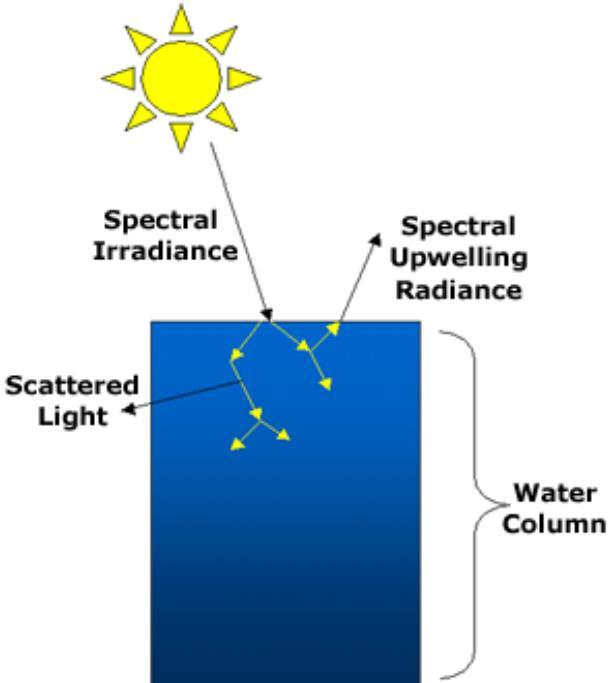

40 40 Basic principles of satellite measurements of ocean color
 wavelength and almost zero in yellow and red Higher is phytoplankton (ie, chlorophyll and other plant pigments) concentration, more is contribution of green color (B) In coastal zones with")
41 Principles of satellite measurements of ocean color Ocean color can be measured on the basis of the spectrum of visible light emitted from the study object Clean ocean water (A) has maximum in short (blue) wavelength and almost zero in yellow and red Higher is phytoplankton (ie, chlorophyll and other plant pigments) concentration, more is contribution of green color (B) In coastal zones with high concentration of dead organic and inorganic matter light spectrum has maximum in red (C) 41
42 Sources of ocean color change Phytoplankton and its pigments Dissolved organic material -- Colored Dissolved Organic Material (CDOM, or yellow matter, or gelbstoff) from decaying vegetable matter (land) and phytoplankton degraded by grazing of photolysis Suspended particulate matter -- The organic particulates (detritus) consist of phytoplankton and zooplankton cell fragments and zooplankton fecal pellets -- The inorganic particulates consist of sand and dust created by erosion of land-based rocks and soils These enter the ocean through: -- River runoff -- Deposition of wind-blown dust -- Wave or current suspension of bottom sediments 42
43 Current ocean color sensors 43

44 CZCS -- Coastal Zone Color Scanner ( ) was a multispectral line scanner developed by NASA to measure ocean color Sun-synchronous, near polar CZCS was launched aboard Nimbus-7 satellite platform in October
 The SeaWiFS program was started in")

")
45 SeaWiFS-- Sea-viewing Wide Field-of-view Sensor (since 1997) The SeaWiFS program was started in 1980s, immediately after the end of the CZCS mission Sun Synchronous orbit launched on August 1, 1997 by SeaStar Space Craft Ocean Chl and Normalized Digital Vegetation Index (NDVI) computed from SeaWiFS 45

 Aqua passes S to N over the equator in the afternoon (1:30 pm, ascending")
46 MODIS--Moderate Resolution Imaging Spectroradiometer Two MODIS sensors: -- Terra satellite launched December 18th, Aqua satellite launched May 4th, 2002 Both have sun-synchronous nearpolar orbit Terra's orbit around the Earth is timed so that it passes from N to S across the equator in the morning (10:30 am, descending node) Aqua passes S to N over the equator in the afternoon (1:30 pm, ascending node) 46
GEOSC/METEO 597K Kevin Bowley Kaitlin Walsh
 GEOSC/METEO 597K Kevin Bowley Kaitlin Walsh Timeline of Satellites ERS-1 (1991-2000) NSCAT (1996) Envisat (2002) RADARSAT (2007) Seasat (1978) TOPEX/Poseidon (1992-2005) QuikSCAT (1999) Jason-2 (2008)
Advances in Satellite Oceanography
 Advances in Satellite Oceanography (Monitoring Earth s water resources) Ebenezer Nyadjro US Naval Research Lab/ University of New Orleans UG-DMFS Summer Program (AUGUST 1-5, 2016) Outline: Remote Sensing:
PRINCIPLES OF REMOTE SENSING. Electromagnetic Energy and Spectral Signatures
 PRINCIPLES OF REMOTE SENSING Electromagnetic Energy and Spectral Signatures Remote sensing is the science and art of acquiring and analyzing information about objects or phenomena from a distance. As humans,
Remote Sensing in Meteorology: Satellites and Radar. AT 351 Lab 10 April 2, Remote Sensing
 Remote Sensing in Meteorology: Satellites and Radar AT 351 Lab 10 April 2, 2008 Remote Sensing Remote sensing is gathering information about something without being in physical contact with it typically
REMOTE SENSING KEY!!
 REMOTE SENSING KEY!! This is a really ugly cover page I m sorry. Name Key. Score / 100 Directions: You have 50 minutes to take this test. You may use a cheatsheet (2 pages), a non-graphing calculator,
REMOTE SENSING TEST!!
 REMOTE SENSING TEST!! This is a really ugly cover page I m sorry. Name. Score / 100 Directions: (idk if I need to put this???) You have 50 minutes to take this test. You may use a cheatsheet (2 pages),
Interpretation of Polar-orbiting Satellite Observations. Atmospheric Instrumentation
 Interpretation of Polar-orbiting Satellite Observations Outline Polar-Orbiting Observations: Review of Polar-Orbiting Satellite Systems Overview of Currently Active Satellites / Sensors Overview of Sensor
Lectures 7 and 8: 14, 16 Oct Sea Surface Temperature
 Lectures 7 and 8: 14, 16 Oct 2008 Sea Surface Temperature References: Martin, S., 2004, An Introduction to Ocean Remote Sensing, Cambridge University Press, 454 pp. Chapter 7. Robinson, I. S., 2004, Measuring
Reminder: All answers MUST GO ON ANSWER SHEET! Answers recorded in the exam booklet will not count.
 Reminder: All answers MUST GO ON ANSWER SHEET! Answers recorded in the exam booklet will not count. 1. Identify the following acronyms; compare these platform types; provide situations where one platform
Remote Sensing I: Basics
 Remote Sensing I: Basics Kelly M. Brunt Earth System Science Interdisciplinary Center, University of Maryland Cryospheric Science Laboratory, Goddard Space Flight Center kelly.m.brunt@nasa.gov (Based on
TIROS-1. 1) National Aeronautics and Space Administration 2) National Oceanic and Atmospheric Administration
 National Aeronautics and Space Administration 2) National Oceanic and Atmospheric Administration") NOAA TIROS-1 NASA 1) National Aeronautics and Space Administration 2) National Oceanic and Atmospheric Administration Sputnik Sputlink Aerobee Aerobee TIROS-1 TIROS-1 1) Spiral swirl SeaWIFS Orb View2
NOAA TIROS-1 NASA 1) National Aeronautics and Space Administration 2) National Oceanic and Atmospheric Administration Sputnik Sputlink Aerobee Aerobee TIROS-1 TIROS-1 1) Spiral swirl SeaWIFS Orb View2
What are Aerosols? Suspension of very small solid particles or liquid droplets Radii typically in the range of 10nm to
 What are Aerosols? Suspension of very small solid particles or liquid droplets Radii typically in the range of 10nm to 10µm Concentrations decrease exponentially with height N(z) = N(0)exp(-z/H) Long-lived
Land Surface Temperature Measurements From the Split Window Channels of the NOAA 7 Advanced Very High Resolution Radiometer John C.
 Land Surface Temperature Measurements From the Split Window Channels of the NOAA 7 Advanced Very High Resolution Radiometer John C. Price Published in the Journal of Geophysical Research, 1984 Presented
History of Aerosol Remote Sensing. Mark Smithgall Maria Zatko 597K Spring 2009
 History of Aerosol Remote Sensing Mark Smithgall Maria Zatko 597K Spring 2009 Aerosol Sources Anthropogenic Biological decomposition from fertilizer and sewage treatment (ex. ammonium) Combustion of fossil
Lesson III: Ocean Color: Energy, Temperature, and the Big Picture
 Lesson III: Ocean Color: Energy, Temperature, and the Big Picture In this lesson we will discuss the Electromagnetic spectrum, electromagnetic energy and sea surface temperature. The electromagnetic (EM)
PREDICTION AND MONITORING OF OCEANIC DISASTERS USING MICROWAVE REMOTE SENSING TECHNIQUES
 PREDICTION AND MONITORING OF OCEANIC DISASTERS USING MICROWAVE REMOTE SENSING TECHNIQUES O P N Calla International Centre for Radio Science, OM NIWAS A-23, Shastri Nagar, Jodhpur-342 003 Abstract The disasters
HY-2A Satellite User s Guide
 National Satellite Ocean Application Service 2013-5-16 Document Change Record Revision Date Changed Pages/Paragraphs Edit Description i Contents 1 Introduction to HY-2 Satellite... 1 2 HY-2 satellite data
9/12/2011. Training Course Remote Sensing - Basic Theory & Image Processing Methods September 2011
 Training Course Remote Sensing - Basic Theory & Image Processing Methods 19 23 September 2011 Introduction to Remote Sensing Michiel Damen (September 2011) damen@itc.nl 1 Overview Electro Magnetic (EM)
Prentice Hall EARTH SCIENCE. Tarbuck Lutgens
 Prentice Hall EARTH SCIENCE Tarbuck Lutgens Chapter 17 The Atmosphere: Structure and Temperature 17.1 Atmosphere Characteristics Composition of the Atmosphere Weather is constantly changing, and it refers
SATELLITE DATA COLLECTION BY THE UPRM-TCESS SPACE INFORMATION LABORATORY
 SATELLITE DATA COLLECTION BY THE UPRM-TCESS SPACE INFORMATION LABORATORY Visita a la Estación De Satélites De UPRM En el CID 16 sep. 4:30 pm Nos reuniremos al frente del CID. CID L-BAND ANTENNA Orbview
Remote Sensing How we know what we know A Brief Tour
 Remote Sensing How we know what we know A Brief Tour Dr. Erik Richard Dr. Jerald Harder LASP Richard 1 Remote Sensing The measurement of physical variables (usually light or sound) from outside of a medium
REVISION OF THE STATEMENT OF GUIDANCE FOR GLOBAL NUMERICAL WEATHER PREDICTION. (Submitted by Dr. J. Eyre)
") WORLD METEOROLOGICAL ORGANIZATION Distr.: RESTRICTED CBS/OPAG-IOS (ODRRGOS-5)/Doc.5, Add.5 (11.VI.2002) COMMISSION FOR BASIC SYSTEMS OPEN PROGRAMME AREA GROUP ON INTEGRATED OBSERVING SYSTEMS ITEM: 4 EXPERT
WORLD METEOROLOGICAL ORGANIZATION Distr.: RESTRICTED CBS/OPAG-IOS (ODRRGOS-5)/Doc.5, Add.5 (11.VI.2002) COMMISSION FOR BASIC SYSTEMS OPEN PROGRAMME AREA GROUP ON INTEGRATED OBSERVING SYSTEMS ITEM: 4 EXPERT
Lecture 4b: Meteorological Satellites and Instruments. Acknowledgement: Dr. S. Kidder at Colorado State Univ.
 Lecture 4b: Meteorological Satellites and Instruments Acknowledgement: Dr. S. Kidder at Colorado State Univ. US Geostationary satellites - GOES (Geostationary Operational Environmental Satellites) US
GEOG Lecture 8. Orbits, scale and trade-offs
 Environmental Remote Sensing GEOG 2021 Lecture 8 Orbits, scale and trade-offs Orbits revisit Orbits geostationary (36 000 km altitude) polar orbiting (200-1000 km altitude) Orbits revisit Orbits geostationary
The Atmosphere. Composition of the Atmosphere. Section 2
 The Atmosphere Earth is surrounded by a mixture of gases known as the Nitrogen, oxygen, carbon dioxide, and other gases are all parts of this mixture. Earth s atmosphere changes constantly as these gases
Atmospheric Lidar The Atmospheric Lidar (ATLID) is a high-spectral resolution lidar and will be the first of its type to be flown in space.
 is a high-spectral resolution lidar and will be the first of its type to be flown in space.") www.esa.int EarthCARE mission instruments ESA s EarthCARE satellite payload comprises four instruments: the Atmospheric Lidar, the Cloud Profiling Radar, the Multi-Spectral Imager and the Broad-Band Radiometer.
www.esa.int EarthCARE mission instruments ESA s EarthCARE satellite payload comprises four instruments: the Atmospheric Lidar, the Cloud Profiling Radar, the Multi-Spectral Imager and the Broad-Band Radiometer.
The Atmosphere: Structure and Temperature
 Chapter The Atmosphere: Structure and Temperature Geologists have uncovered evidence of when Earth was first able to support oxygenrich atmosphere similar to what we experience today and more so, take
EUMETSAT STATUS AND PLANS
 1 EUM/TSS/VWG/15/826793 07/10/2015 EUMETSAT STATUS AND PLANS François Montagner, Marine Applications Manager, EUMETSAT WMO Polar Space Task Group 5 5-7 October 2015, DLR, Oberpfaffenhofen PSTG Strategic
Remote sensing of sea ice
 Remote sensing of sea ice Ice concentration/extent Age/type Drift Melting Thickness Christian Haas Remote Sensing Methods Passive: senses shortwave (visible), thermal (infrared) or microwave radiation
- satellite orbits. Further Reading: Chapter 04 of the text book. Outline. - satellite sensor measurements
 (1 of 12) Further Reading: Chapter 04 of the text book Outline - satellite orbits - satellite sensor measurements - remote sensing of land, atmosphere and oceans (2 of 12) Introduction Remote Sensing:
The Water Planet Ch. 22
 The Water Planet Ch. 22 What is Oceanography? the study of the Earth s oceans using chemistry, biology, geology, and physics. Oceans cover 70% of the Earth s surface Ocean Research 22.1 The use of submarines
Chapter 4 Nadir looking UV measurement. Part-I: Theory and algorithm
 Chapter 4 Nadir looking UV measurement. Part-I: Theory and algorithm -Aerosol and tropospheric ozone retrieval method using continuous UV spectra- Atmospheric composition measurements from satellites are
Lecture 19: Operational Remote Sensing in Visible, IR, and Microwave Channels
 MET 4994 Remote Sensing: Radar and Satellite Meteorology MET 5994 Remote Sensing in Meteorology Lecture 19: Operational Remote Sensing in Visible, IR, and Microwave Channels Before you use data from any
Operational systems for SST products. Prof. Chris Merchant University of Reading UK
 Operational systems for SST products Prof. Chris Merchant University of Reading UK Classic Images from ATSR The Gulf Stream ATSR-2 Image, ƛ = 3.7µm Review the steps to get SST using a physical retrieval
FUNDAMENTALS OF REMOTE SENSING FOR RISKS ASSESSMENT. 1. Introduction
 FUNDAMENTALS OF REMOTE SENSING FOR RISKS ASSESSMENT FRANÇOIS BECKER International Space University and University Louis Pasteur, Strasbourg, France; E-mail: becker@isu.isunet.edu Abstract. Remote sensing
Spectral reflectance: When the solar radiation is incident upon the earth s surface, it is either
 Spectral reflectance: When the solar radiation is incident upon the earth s surface, it is either reflected by the surface, transmitted into the surface or absorbed and emitted by the surface. Remote sensing
ElectroMagnetic Radiation (EMR) Lecture 2-3 August 29 and 31, 2005
 Lecture 2-3 August 29 and 31, 2005") ElectroMagnetic Radiation (EMR) Lecture 2-3 August 29 and 31, 2005 Jensen, Jensen, Ways of of Energy Transfer Energy is is the the ability to to do do work. In In the the process of of doing work, energy
ElectroMagnetic Radiation (EMR) Lecture 2-3 August 29 and 31, 2005 Jensen, Jensen, Ways of of Energy Transfer Energy is is the the ability to to do do work. In In the the process of of doing work, energy
Chapter 1: Introduction
 Chapter 1: Introduction Photogrammetry: Definition & applications What are we trying to do? Data acquisition systems 3-D viewing of 2-D imagery Automation (matching problem) Necessary tools: Image formation
Reflectivity in Remote Sensing
 Reflectivity in Remote Sensing The amount of absorbance and reflection of white light by a substance is dependent upon the molecular makeup of the substance. Humans have used dyes for years to obtain colors-
Directed Reading. Section: Solar Energy and the Atmosphere RADIATION. identical point on the next wave. waves
 Skills Worksheet Directed Reading Section: Solar Energy and the Atmosphere 1. How is Earth s atmosphere heated? 2. Name the two primary sources of heat in the atmosphere. RADIATION In the space provided,
1. The frequency of an electromagnetic wave is proportional to its wavelength. a. directly *b. inversely
 CHAPTER 3 SOLAR AND TERRESTRIAL RADIATION MULTIPLE CHOICE QUESTIONS 1. The frequency of an electromagnetic wave is proportional to its wavelength. a. directly *b. inversely 2. is the distance between successive
Lecture 4: Radiation Transfer
 Lecture 4: Radiation Transfer Spectrum of radiation Stefan-Boltzmann law Selective absorption and emission Reflection and scattering Remote sensing Importance of Radiation Transfer Virtually all the exchange
Chapter 2. Heating Earth's Surface & Atmosphere
 Chapter 2 Heating Earth's Surface & Atmosphere Topics Earth-Sun Relationships Energy, Heat and Temperature Mechanisms of Heat Transfer What happens to Incoming Solar Radiation? Radiation Emitted by the
Impacts of Atmospheric Corrections on Algal Bloom Detection Techniques
 1 Impacts of Atmospheric Corrections on Algal Bloom Detection Techniques Ruhul Amin, Alex Gilerson, Jing Zhou, Barry Gross, Fred Moshary and Sam Ahmed Optical Remote Sensing Laboratory, the City College
Chapter 4 Lesson 1: Describing Earth s Atmosphere
 Chapter 4 Lesson 1: Describing Earth s Atmosphere Vocabulary Importance of Earth s Atmosphere The atmosphere is a thin layer of gases surrounding Earth. o Contains the oxygen and water needed for life.
Back to basics: From Sputnik to Envisat, and beyond: The use of satellite measurements in weather forecasting and research: Part 1 A history
 Back to basics: From Sputnik to Envisat, and beyond: The use of satellite measurements in weather forecasting and research: Part 1 A history Roger Brugge 1 and Matthew Stuttard 2 1 NERC Data Assimilation
Climate & Earth System Science. Introduction to Meteorology & Climate. Chapter 05 SOME OBSERVING INSTRUMENTS. Instrument Enclosure.
 Climate & Earth System Science Introduction to Meteorology & Climate MAPH 10050 Peter Lynch Peter Lynch Meteorology & Climate Centre School of Mathematical Sciences University College Dublin Meteorology
(Refer Slide Time: 3:48)
") Introduction to Remote Sensing Dr. Arun K Saraf Department of Earth Sciences Indian Institute of Technology Roorkee Lecture 01 What is Satellite based Remote Sensing Hello, hello everyone this is Arun
Introduction to Remote Sensing Dr. Arun K Saraf Department of Earth Sciences Indian Institute of Technology Roorkee Lecture 01 What is Satellite based Remote Sensing Hello, hello everyone this is Arun
The Atmosphere and Atmospheric Energy Chapter 3 and 4
 The Atmosphere and Atmospheric Energy Chapter 3 and 4 Size of the Earth s Atmosphere Atmosphere produced over 4.6 billion years of development Protects us from radiation Completely surrounds the earth
CGMS Baseline. Sustained contributions to the Global Observing System. Endorsed by CGMS-46 in Bengaluru, June 2018
 CGMS Baseline Sustained contributions to the Global Observing System Best Practices for Achieving User Readiness for New Meteorological Satellites Endorsed by CGMS-46 in Bengaluru, June 2018 CGMS/DOC/18/1028862,
Status of Indian Satellite Meteorological Programme
 Status of Indian Satellite Meteorological Programme Pradeep K Thapliyal Space Applications Centre (SAC) Indian Space research Organisation (ISRO) Ahmedabad (INDIA) Email: pkthapliyal@sac.isro.gov.in International
GCOM-W1 now on the A-Train
 GCOM-W1 now on the A-Train GCOM-W1 Global Change Observation Mission-Water Taikan Oki, K. Imaoka, and M. Kachi JAXA/EORC (& IIS/The University of Tokyo) Mini-Workshop on A-Train Science, March 8 th, 2013
GMES: calibration of remote sensing datasets
 GMES: calibration of remote sensing datasets Jeremy Morley Dept. Geomatic Engineering jmorley@ge.ucl.ac.uk December 2006 Outline Role of calibration & validation in remote sensing Types of calibration
Radiation balance of the Earth. 6. Earth radiation balance under present day conditions. Top of Atmosphere (TOA) Radiation balance
 Radiation balance") Radiation balance of the Earth Top of Atmosphere (TOA) radiation balance 6. Earth radiation balance under present day conditions Atmospheric radiation balance: Difference between TOA and surface radiation
Radiation balance of the Earth Top of Atmosphere (TOA) radiation balance 6. Earth radiation balance under present day conditions Atmospheric radiation balance: Difference between TOA and surface radiation
Satellites, Weather and Climate Module 1: Introduction to the Electromagnetic Spectrum
 Satellites, Weather and Climate Module 1: Introduction to the Electromagnetic Spectrum What is remote sensing? = science & art of obtaining information through data analysis, such that the device is not
Section 2: The Atmosphere
 Section 2: The Atmosphere Preview Classroom Catalyst Objectives The Atmosphere Composition of the Atmosphere Air Pressure Layers of the Atmosphere The Troposphere Section 2: The Atmosphere Preview, continued
,Solar Energy, Greenhouse effect, Convection.notebook October 31, 2016
 Essential Question: How is weather created? What is Solar Energy? The driving source of energy for Earth. 1. Heats Earth's land, water, and air. 2. Causes movement in the atmosphere. Key Topics: The sun
A Comparative Study and Intercalibration Between OSMI and SeaWiFS
 A Comparative Study and Intercalibration Between OSMI and SeaWiFS KOMPSAT-1 Bryan A. Franz NASA SIMBIOS Project Yongseung Kim Korea Aerospace Research Institute ORBVIEW-2 Abstract Since 1996, following
Earth s Atmosphere. Energy Transfer in the Atmosphere. 3. All the energy from the Sun reaches Earth s surface.
 CHAPTER 11 LESSON 2 Earth s Atmosphere Energy Transfer in the Atmosphere Key Concepts How does energy transfer from the Sun to Earth and to the atmosphere? How are air circulation patterns within the atmosphere
Annex VI-1. Draft National Report on Ocean Remote Sensing in China. (Reviewed by the Second Meeting of NOWPAP WG4)
") UNEP/NOWPAP/CEARAC/WG4 2/9 Page1 Draft National Report on Ocean Remote Sensing in China (Reviewed by the Second Meeting of NOWPAP WG4) UNEP/NOWPAP/CEARAC/WG4 2/9 Page1 1. Status of RS utilization in marine
UNEP/NOWPAP/CEARAC/WG4 2/9 Page1 Draft National Report on Ocean Remote Sensing in China (Reviewed by the Second Meeting of NOWPAP WG4) UNEP/NOWPAP/CEARAC/WG4 2/9 Page1 1. Status of RS utilization in marine
Lectures 7 and 8: 13, 18 Feb Sea Surface Temperature
 Lectures 7 and 8: 13, 18 Feb 2008 Sea Surface Temperature References: Martin, S., 2004, An Introduction to Ocean Remote Sensing, Cambridge University Press, 454 pp. Chapter 7. Robinson, I. S., 2004, Measuring
Climate Change Lecture Notes
 Climate Change Lecture Notes (Topic 12A) page 1 Climate Change Lecture Notes Learning Outcomes for the Climate Change Unit 1. Students can list observations which suggest that the world is warming, and
Electromagnetic Radiation (EMR)
") Electromagnetic Radiation (EMR) It is kind of energy with wave character ( exactly as sea waves ) that can be characterized by : Wavelength ( ) : The distance between two identical points on the wave.
Electromagnetic Radiation (EMR) It is kind of energy with wave character ( exactly as sea waves ) that can be characterized by : Wavelength ( ) : The distance between two identical points on the wave.
The Atmosphere of Earth
 The Atmosphere of Earth The probability of a storm can be predicted, but nothing can be done to stop or slow a storm. Understanding the atmosphere may help in predicting weather changes, but it is doubtful
NASA's Plankton, Aerosol, Cloud, ocean Ecosystem (PACE) mission update
 mission update") NASA's Plankton, Aerosol, Cloud, ocean Ecosystem (PACE) mission update Antonio Mannino1, Jeremy Werdell1, Brian Cairns2 NASA GSFC1 and GISS2 Acknowledgments: PACE Team https://pace.gsfc.nasa.gov 1 Outline
NASA's Plankton, Aerosol, Cloud, ocean Ecosystem (PACE) mission update Antonio Mannino1, Jeremy Werdell1, Brian Cairns2 NASA GSFC1 and GISS2 Acknowledgments: PACE Team https://pace.gsfc.nasa.gov 1 Outline
The Atmosphere. Characteristics of the Atmosphere. Section 23.1 Objectives. Chapter 23. Chapter 23 Modern Earth Science. Section 1
 The Atmosphere Chapter 23 Modern Earth Science Characteristics of the Atmosphere Chapter 23 Section 1 Section 23.1 Objectives Describe the composition of Earth s atmosphere. Explain how two types of barometers
Estimation of ocean contribution at the MODIS near-infrared wavelengths along the east coast of the U.S.: Two case studies
 GEOPHYSICAL RESEARCH LETTERS, VOL. 32, L13606, doi:10.1029/2005gl022917, 2005 Estimation of ocean contribution at the MODIS near-infrared wavelengths along the east coast of the U.S.: Two case studies
Influence of Clouds and Aerosols on the Earth s Radiation Budget Using Clouds and the Earth s Radiant Energy System (CERES) Measurements
 Measurements") Influence of Clouds and Aerosols on the Earth s Radiation Budget Using Clouds and the Earth s Radiant Energy System (CERES) Measurements Norman G. Loeb Hampton University/NASA Langley Research Center Bruce
Influence of Clouds and Aerosols on the Earth s Radiation Budget Using Clouds and the Earth s Radiant Energy System (CERES) Measurements Norman G. Loeb Hampton University/NASA Langley Research Center Bruce
Learning Objectives. Thermal Remote Sensing. Thermal = Emitted Infrared
 November 2014 lava flow on Kilauea (USGS Volcano Observatory) (http://hvo.wr.usgs.gov) Landsat-based thermal change of Nisyros Island (volcanic) Thermal Remote Sensing Distinguishing materials on the ground
T. Dale Bess 1 and Takmeng Wong Atmospheric Sciences Division Langley Research Center, NASA Hampton, VA G. Louis Smith
 P1.7 ONE YEAR OF DAILY AVERAGED LONGWAVE RADIATION MEASUREMENTS FOR ENVIRONMENTAL AND CLIMATE CHANGE STUDIES T. Dale Bess 1 and Takmeng Wong Atmospheric Sciences Division Langley Research Center, NASA
GCOM-C/SGLI and its Lunar Calibration
 GCOM-C/SGLI and its Lunar Calibration Lunar Calibration Workshop December 1-4, 2014 JAXA/GCOM Proj. Yoshihiko Okamura (okamura.yoshihiko@jaxa.jp) 1. Overview of GCOM-C satellite and SGLI (1) Global Change
INTRODUCTION TO MICROWAVE REMOTE SENSING. Dr. A. Bhattacharya
 1 INTRODUCTION TO MICROWAVE REMOTE SENSING Dr. A. Bhattacharya Why Microwaves? More difficult than with optical imaging because the technology is more complicated and the image data recorded is more varied.
Inaugural University of Michigan Science Olympiad Tournament
 Inaugural University of Michigan Science Olympiad Tournament The test may be taken apart. Ties will be broken based on predetermined questions and quality of response. Remote Sensing Test length: 50 Minutes
A) usually less B) dark colored and rough D) light colored with a smooth surface A) transparency of the atmosphere D) rough, black surface
 usually less B) dark colored and rough D) light colored with a smooth surface A) transparency of the atmosphere D) rough, black surface") 1. Base your answer to the following question on the diagram below which shows two identical houses, A and B, in a city in North Carolina. One house was built on the east side of a factory, and the other
1. Base your answer to the following question on the diagram below which shows two identical houses, A and B, in a city in North Carolina. One house was built on the east side of a factory, and the other
Table of Contents. Chapter: Atmosphere. Section 1: Earth's Atmosphere. Section 2: Energy Transfer in the Atmosphere. Section 3: Air Movement
 Table of Contents Chapter: Atmosphere Section 1: Earth's Atmosphere Section 2: Energy Transfer in the Atmosphere Section 3: Air Movement Table of Contents Chapter 4: Atmosphere Section 1: Earth's Atmosphere
Monitoring Sea Surface temperature change at the Caribbean Sea, using AVHRR images. Y. Santiago Pérez, and R. Mendez Yulfo
 Monitoring Sea Surface temperature change at the Caribbean Sea, using AVHRR images. Y. Santiago Pérez, and R. Mendez Yulfo Department of Geology, University of Puerto Rico Mayagüez Campus, P.O. Box 9017,
Chapter 11 Lecture Outline. Heating the Atmosphere
 Chapter 11 Lecture Outline Heating the Atmosphere They are still here! Focus on the Atmosphere Weather Occurs over a short period of time Constantly changing Climate Averaged over a long period of time
Topic 5 Practice Test
 Base your answers to questions 1 and 2 on the diagram below, which represents the greenhouse effect in which heat energy is trapped in Earth's atmosphere 1. The Earth surface that best absorbs short-wave
Application Status and Prospect of Microwave Remote Sensing
 2017 International Conference on Computing, Communications and Automation(I3CA 2017) Application Status and Prospect of Microwave Remote Sensing Cheng Lele, Yan Xinsui, Zhou Mengqiu, Zhou Yongqin, Wang
ATMOSPHERE PACKET CHAPTER 22 PAGES Section 1 page 546
 Name: Period: ATMOSPHERE PACKET CHAPTER 22 PAGES 546-564 Section 1 page 546 1. Identify five main components of the atmosphere 2. Explain the cause of atmospheric pressure. 3. Why is atmospheric pressure
Biological Oceanography by Remote Sensing. M.A. Srokosz
 Biological Oceanography by Remote Sensing M.A. Srokosz in Encyclopedia of Analytical Chemistry R.A. Meyers (Ed.) pp. 8506 8533 John Wiley & Sons Ltd, Chichester, 2000 BIOLOGICAL OCEANOGRAPHY BY REMOTE
APPENDIX 2 OVERVIEW OF THE GLOBAL PRECIPITATION MEASUREMENT (GPM) AND THE TROPICAL RAINFALL MEASURING MISSION (TRMM) 2-1
 AND THE TROPICAL RAINFALL MEASURING MISSION (TRMM) 2-1") APPENDIX 2 OVERVIEW OF THE GLOBAL PRECIPITATION MEASUREMENT (GPM) AND THE TROPICAL RAINFALL MEASURING MISSION (TRMM) 2-1 1. Introduction Precipitation is one of most important environmental parameters.
APPENDIX 2 OVERVIEW OF THE GLOBAL PRECIPITATION MEASUREMENT (GPM) AND THE TROPICAL RAINFALL MEASURING MISSION (TRMM) 2-1 1. Introduction Precipitation is one of most important environmental parameters.
Principles of Satellite Remote Sensing
 Chapter 5 Principles of Satellite Remote Sensing Goal: Give a overview on the characteristics of satellite remote sensing. Satellites have several unique characteristics which make them particularly useful
Introduction to RS Lecture 2. NR401 Dr. Avik Bhattacharya 1
 Introduction to RS Lecture 2 NR401 Dr. Avik Bhattacharya 1 This course is about electromagnetic energy sensors other types of remote sensing such as geophysical will be disregarded. For proper analysis
School on Modelling Tools and Capacity Building in Climate and Public Health April Remote Sensing
 2453-5 School on Modelling Tools and Capacity Building in Climate and Public Health 15-26 April 2013 Remote Sensing CECCATO Pietro International Research Institute for Climate and Society, IRI The Earth
UNIT I EMR AND ITS INTERACTION WITH ATMOSPHERE & EARTH MATERIAL
 Date deliverance : UNIT I EMR AND ITS INTERACTION WITH ATMOSPHERE & EARTH MATERIAL Definition remote sensing and its components Electromagnetic spectrum wavelength regions important to remote sensing Wave
Projects in the Remote Sensing of Aerosols with focus on Air Quality
 Projects in the Remote Sensing of Aerosols with focus on Air Quality Faculty Leads Barry Gross (Satellite Remote Sensing), Fred Moshary (Lidar) Direct Supervision Post-Doc Yonghua Wu (Lidar) PhD Student
Monitoring Air Pollution from Space
 Monitoring Air Pollution from Space Media Regional Training Workshop 16 th Nov 20 th Nov 2015 Shreta Ghimire International Centre for Integrated Mountain Development Kathmandu, Nepal Why do we study air
APPLICATIONS WITH METEOROLOGICAL SATELLITES. W. Paul Menzel. Office of Research and Applications NOAA/NESDIS University of Wisconsin Madison, WI
 APPLICATIONS WITH METEOROLOGICAL SATELLITES by W. Paul Menzel Office of Research and Applications NOAA/NESDIS University of Wisconsin Madison, WI July 2004 Unpublished Work Copyright Pending TABLE OF CONTENTS
Electromagnetic Waves
 ELECTROMAGNETIC RADIATION AND THE ELECTROMAGNETIC SPECTRUM Electromagnetic Radiation (EMR) THE ELECTROMAGNETIC SPECTRUM Electromagnetic Waves A wave is characterized by: Wavelength (λ - lambda) is the
LESSON THREE Time, Temperature, Chlorophyll a Does sea surface temperature affect chlorophyll a concentrations?
 STUDENT PAGES LESSON THREE A partnership between California Current Ecosystem Long Term Ecological Research (CCE LTER) and Ocean Institute (OI) Beth Simmons, Education and Outreach Coordinator, CCE LTER,
Atmospheric Measurements from Space
 Atmospheric Measurements from Space MPI Mainz Germany Thomas Wagner Satellite Group MPI Mainz Part 1: Basics Break Part 2: Applications Part 1: Basics of satellite remote sensing Why atmospheric satellite
New NASA Ocean Observations and Coastal Applications
 New NASA Ocean Observations and Coastal Applications Duane Armstrong Chief, Applied Science & Technology Project Office August 20, 2014 1 Outline NASA s new Earth Science Ocean Science Missions for 2014
Detecting the Red Edge of absorption in Puget Sound from Satellite measured water-leaving radiance
 Detecting the Red Edge of absorption in Puget Sound from Satellite measured water-leaving radiance Rachel Halfhill University of Washington School of Oceanography The Pacific Northwest Center for Human
Lesson 2. Antarctic Oceanography: Component I - Ice/Glaciers Component II - Marine Snow
 Lesson 2. Antarctic Oceanography: Component I - Ice/Glaciers Component II - Marine Snow Lesson Objectives: Introduces students to the different kinds of ice found in Antarctica, Students will become familiar
Remote Sensing and GIS. Microwave Remote Sensing and its Applications
 Subject Paper No and Title Module No and Title Module Tag Geology Remote Sensing and GIS Microwave Remote Sensing and its Applications RS & GIS XVII Principal Investigator Co-Principal Investigator Co-Principal
Greenhouse Effect. Julia Porter, Celia Hallan, Andrew Vrabel Miles, Gary DeFrance, and Amber Rose
 Greenhouse Effect Julia Porter, Celia Hallan, Andrew Vrabel Miles, Gary DeFrance, and Amber Rose What is the Greenhouse Effect? The greenhouse effect is a natural occurrence caused by Earth's atmosphere
PRINCIPLES OF REMOTE SENSING. Shefali Aggarwal Photogrammetry and Remote Sensing Division Indian Institute of Remote Sensing, Dehra Dun
 PRINCIPLES OF REMOTE SENSING Shefali Aggarwal Photogrammetry and Remote Sensing Division Indian Institute of Remote Sensing, Dehra Dun Abstract : Remote sensing is a technique to observe the earth surface
CGMS Baseline In response to CGMS action/recommendation A45.01 HLPP reference: 1.1.8
 Prepared by WGIII Agenda Item: 7.1 Discussed in WGIII CGMS Baseline In response to CGMS action/recommendation A45.01 HLPP reference: 1.1.8 In CGMS-45, Working Group III agreed to hold a review of the CGMS
Physical Basics of Remote-Sensing with Satellites
 - Physical Basics of Remote-Sensing with Satellites Dr. K. Dieter Klaes EUMETSAT Meteorological Division Am Kavalleriesand 31 D-64295 Darmstadt dieter.klaes@eumetsat.int Slide: 1 EUM/MET/VWG/09/0162 MET/DK