GRACE Cloudsat CALIPSO Aqua. Metop TRMM TOPEX. Meteor/ SAGE GIFTS NOAA/ POES. Landsat GOES MTSAT. SeaWiFS. Aura. Terra MSG. Jason ICESat SORCE
|
|
|
- Stanley Smith
- 6 years ago
- Views:
Transcription


1


2 TRMM Metop GRACE Cloudsat CALIPSO Aqua TOPEX Meteor/ SAGE GIFTS NOAA/ POES Landsat GOES SeaWiFS MTSAT Terra Aura Jason ICESat SORCE MSG

3 THE EARTH SYSTEM SCIENCE It is the science that studies the whole Earth as a system of many interacting parts and focuses on the changes within and between those parts.

4 THE EARTH SYSTEM
, and from Earth-Moon-Sun tidal interactions (a very small")
5 THE EARTH'S ENERGY BUDGET Three main sources: external (solar radiation), internal (geothermal energy), and from Earth-Moon-Sun tidal interactions (a very small component).
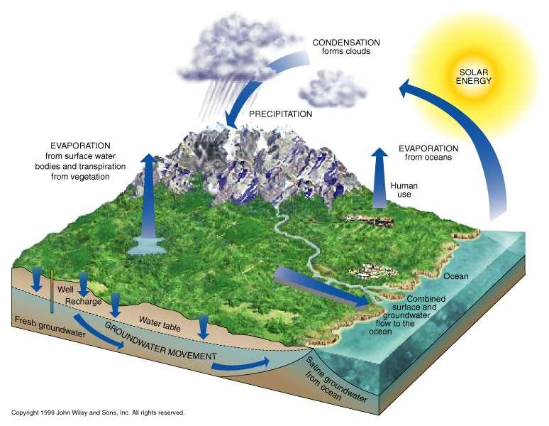
6 THE HYDROLOGIC CYCLE

7

8

9

10

11 THE GREENHOUSE EFFECT

12 Concentration of carbon dioxide in dry air, since 1958, measured at the Mauna Loa Observatory, Hawaii (given in parts per million by volume = ppbv/1000). Annual fluctuations reflect seasonal changes in biologic uptake of CO2, while the long-term trend shows a persistent increase in the atmospheric concentration of this greenhouse gas.
.")
13 Since the beginning of the Industrial Revolution, about 1850, the atmospheric concentration of CO2 has risen at an increasing rate (A). The increase matches the increasing rate at which CO2 has been released through the burning of fossil fuels (B).

14 CLIMATE CHANGE

15 EARTH'S CLIMATE SYSTEM

16 ESTIMATES OF FUTURE AVERAGE GLOBAL TEMPERATURE RISE DUE TO THE GREENHOUSE EFFECT BASED ON DIFFERENT ASSUMPTIONS A = "Business as usual," with energy supply dominated by coal, continuing deforestation, and limited or no control of methane, nitrous oxide, and carbon monoxide emissions. B = A shift toward lower-carbon fuels (e.g., natural gas), coupled with large increases in fuel efficiency, reversal of deforestation trends, and stringent carbon monoxide controls. C = A shift toward renewable sources (solar, hydro-and wind power) and nuclear energy in the second half of the twenty-first century, a phaseout of CFC emissions, and limitations on agricultural methane and nitrous oxide emissions. D = A shift to renewable and nuclear energy in the first half of the twentyfirst century, thereby reducing carbon dioxide emissions to 50 percent of 1985 amounts by 2050, and stabilization of atmospheric concentrations of greenhouse gases through controls in industrialized countries and moderate growth in developing countries.


17 REMOTE SENSING AS A TOOL FOR MONITORING CLIMATE CHANGE


18 Terra and Aqua NASA EARTH OBSERVING SYSTEM Jesus Lee-Borges
19


20
21 SeaWiFS / OrbView-2 (08/1/1997) The purpose of the Sea-viewing Wide Field-of-view Sensor (SeaWiFS) Project is to provide quantitative data on global ocean bio-optical properties to the Earth science community. Subtle changes in ocean color signify various types and quantities of marine phytoplankton (microscopic marine plants), the knowledge of which has both scientific and practical applications. SeaWiFS was successfully launched on the OrbView-2 satellite in August (OrbView-2 is not provided or operated by NASA but is a data buy.) TRMM (11/27/1997) The Tropical Rainfall Measuring Mission (TRMM) is a joint mission between NASA and the National Space Development Agency (NASDA) of Japan. It was designed to monitor and study tropical rainfall and the associated release of energy that helps to power the global atmospheric circulation shaping both weather and climate around the globe. Landsat 7 (04/15/1999) The Landsat Program is the longest running enterprise for acquisition of imagery of the Earth from space. The first Landsat satellite was launched in QuikScat (SeaWinds - 06/19/1999) The SeaWinds instrument on the QuikScat mission is a "quick recovery" mission to fill the gap created by the loss of data from the NASA Scatterometer (NSCAT), when the satellite lost power in June The SeaWinds instrument is a specialized microwave radar that measures near-surface wind speed and direction under all weather and cloud conditions over the Earth's oceans.
22 Terra (12/18/1999) The Terra satellite is the flagship of EOS. It will provide global data on the state of the atmosphere, land, and oceans, as well as their interactions with solar radiation and with one another. ACRIMSAT (12/20/1999) A series of Active Cavity Radiometer Irradiance Monitors (ACRIMs) provides long-term, precise measurements of the total amount of the Sun's energy that falls on our planet's surface, oceans, and atmosphere. NMP/EO-1 (11/21/2000) One of the key responsibilities of NASA's Earth Science Enterprise is to ensure the continuity of future Landsat data. The New Millennium Program's (NMP) first flight, Earth Observing-1 (EO-1), will validate technologies contributing to the reduction in cost of follow-on Landsat missions. The Hyperion instrument will be aboard this spacecraft. METEOR 3M-1/SAGE III (3/2001) The SAGE III mission on the Russian Meteor 3M-1 spacecraft seeks to enhance our understanding of natural and human-derived atmospheric processes by providing high latitude long-term measurements of the vertical structure of aerosols, ozone, water vapor, and other important trace gases in the upper troposphere and stratosphere.
23 Jason-1 (03/2001) Jason is a joint U.S.-France (Centre National d' Etudes Spatiales) oceanography mission designed to monitor global ocean circulation, discover the tie between the oceans and atmosphere, improve global climate predictions, and monitor events such as El Nino and La Nina and ocean eddies. QuikTOMS (04/2001) The Total Ozone Mapping Spectrometer (TOMS) continues NASA's long term mapping of the global distribution of the Earth's atmospheric ozone. In addition to ozone, TOMS measures sulfur-dioxide released in volcanic eruptions. Aqua (formerly EOS PM) (07/2001) The focus for the Aqua satellite is the multidisciplinary study of the Earth's interrelated processes (atmosphere, oceans, and land-surface) and their relationship to Earth system changes. Gravity Recovery and Climate Experiment (11/2001) The second of the Pathfinder missions, GRACE employs a satellite-to-satellite microwave tracking system between two spacecraft to measure the Earth's gravity field and its time variability over five years. Such measurements are directly coupled to long-wavelength ocean circulation processes and to the transport of ocean heat to the Earth's poles.
24 ICESat (12/2001) ICESat is a small satellite mission to fly the Geoscience Laser Altimeter System (GLAS) in a nearpolar orbit in GLAS will accurately measure the elevation of the Earth's ice sheets, clouds, and land. ADEOS II (SeaWinds - 2/2002) The Advanced Earth Observing Satellite II (ADEOS II), the successor to the Advanced Earth Observing Satellite (ADEOS) mission, is a joint mission with the National Space Development Agency (NASDA) of Japan. The mission will take an active part in the research of global climate changes and their effect on weather phenomena. Triana (04/2002) Triana is a mission dedicated to helping scientists construct more accurate models of Earth's climate and answering a key Earth science question--how solar radiation affects climate. Vegetation Canopy Lidar (TBD) The first of the Pathfinder missions, VCL seeks to provide the first global inventory of the vertical structure of forests across Earth using a multibeam laser-ranging device.the mission will enable direct measurement of tree heights, forest canopy structure, and derived parameters such as global biomass with at least ten times better accuracy than existing assessments.
25 SORCE (07/2002) The SOLar STellar Irradiance Comparison Experiment (SOLSTICE) and Total Irradiance Monitor (TIM) onboard the Solar Radiation and Climate Experiment (SORCE) provides the scientific community with longterm, accurate measurements of the solar ultraviolet (UV), far ultraviolet (FUV), and total irradiance from the sun. CloudSat (05/2003) CloudSat's primary goal is to furnish data needed to evaluate and improve the way clouds are parameterized in global models thereby contributing to better predictions of clouds and, thus, to their poorly understood role in affecting climate change through what is referred to as cloud-climate feedback. Aura (formerly EOS Chemistry-1) (6/2003) The Aura satellite will focus on measurements of atmospheric trace gases and their transformations. The objective of the mission is to study the chemistry and dynamics of the Earth's atmosphere from the ground through the mesosphere. PICASSO-CENA (11/2003) The Pathfinder Instruments for Cloud and Aerosol Spaceborne Observations -- Climatologie Etendue des Nuages et des Aerosols (PICASSO-CENA) mission, is a joint mission lead by NASA's Langley Research Center and the Institut Pierre Simon Laplace, Paris. PICASSO-CENA flies in formation with EOS PM-1 to provide global observations of aerosol and cloud properties, radiative fluxes, and atmospheric state. These data will enable new assessments of the radiative effects of aerosol and clouds that will greatly improve our ability to predict future climate change. International Space Station (SAGE III - 11/2003) The SAGE III mission on the Space Station seeks to enhance our understanding of natural and humanderived atmospheric processes by providing high latitude long-term measurements of the vertical structure of aerosols, ozone, water vapor, and other important trace gases in the upper troposphere and stratosphere.

26
 Series of satellites to study the complexities of global change Advanced computer network for processing, storing and distributing data Teams of scientists who will study")
27 TERRA (EOS AM-1) Launched December 18, 1999 Begun collecting data February 24, 2000 Crosses equator at 10:30 am Descending, near polar, sun synchronous, and circular orbit at 705 km Part of EOS (Earth Observing System) Series of satellites to study the complexities of global change Advanced computer network for processing, storing and distributing data Teams of scientists who will study the data
28 TERRA Instruments ASTER (Advanced Spaceborne Thermal Emission and Reflection Radiometer) CERES (Clouds and the Earth s Radiant Energy System) MISR (Multi-angle Imaging Spectro-Radiometer) MOPITT (Measurements of Pollution in the Troposphere) MODIS (Moderate Resolution Imaging Spectroradiometer)


29 ASTER is a cooperative effort between NASA and Japan's Ministry of Economy Trade and Industry (METI), with the collaboration of scientific and industry organizations in both countries. The ASTER instrument provides the next generation in remote sensing imaging capabilities compared with the older Landsat Thematic Mapper, and Japan's JERS-1 OPS scanner. ASTER captures high spatial resolution data in 14 bands, from the visible to the thermal infrared wavelengths; and provides stereo viewing capability for digital elevation model creation. As the "zoom lens" for Terra, ASTER data are used by other Terra and spaceborne instruments for validation and calibration.
 Design to better understand Earth's Water")
30 AQUA EOS PM-1 Launched on May 4, 2002 Crosses equator at 1:30 pm Ascending, near polar, sun synchronous, and circular orbit at 705 km Part of EOS (Earth Observing System) Design to better understand Earth's Water Cycle
31 AQUA Instruments AMSU (Advanced Microwave Sounding Unit) AIRS (Atmospheric Infrared Sounder) HSB (Humidity Sounder for Brazil) CERE (Clouds and the Earth's Radiant Energy System) AMSR/E (Advanced Microwave Scanning Radiometer-EOS) MODIS (Moderate Resolution Imaging Spectroradiometer)
 500 m (bands 3-7) 1000 m (bands 8-36) 36 bands from visible to infrared URL: http://modis-ocean.gsfc.nasa.")
32 MODIS (Moderate Resolution Imaging Spectroradiometer) Swath dimensions: 2330 km (cross track) by 10km (along track at nadir) Spatial resolution 250 m (bands 1-2) 500 m (bands 3-7) 1000 m (bands 8-36) 36 bands from visible to infrared URL:

33


34

35


36

37 May 4, Wildfires in Oregon

")
38 Suomi NPP (National Polar-orbiting Partnership) Launched on October 28, 2011


39 Visible Infrared Imaging Radiometer Suite (VIIRS) is a scanning radiometer, collects visible and infrared imagery and radiometric measurements of the land, atmosphere, cryosphere, and oceans. VIIRS data is used to measure cloud and aerosol properties, ocean color, sea and land surface temperature, ice motion and temperature, fires, and Earth's albedo. Climatologists use VIIRS data to improve our understanding of global climate change. 27-April-2016 (from UPRM Station)


40
National Aeronautics and Space Administration. Earth Day is everyday at NASA. activity booklet
 National Aeronautics and Space Administration Earth Day is everyday at NASA activity booklet Earth Day is everyday at NASA NASA s Fleet of Earth Observing Satellites ACRIMSAT Landsat 7 Aqua SORCE Terra
History of Aerosol Remote Sensing. Mark Smithgall Maria Zatko 597K Spring 2009
 History of Aerosol Remote Sensing Mark Smithgall Maria Zatko 597K Spring 2009 Aerosol Sources Anthropogenic Biological decomposition from fertilizer and sewage treatment (ex. ammonium) Combustion of fossil
Interpretation of Polar-orbiting Satellite Observations. Atmospheric Instrumentation
 Interpretation of Polar-orbiting Satellite Observations Outline Polar-Orbiting Observations: Review of Polar-Orbiting Satellite Systems Overview of Currently Active Satellites / Sensors Overview of Sensor
GEOSC/METEO 597K Kevin Bowley Kaitlin Walsh
 GEOSC/METEO 597K Kevin Bowley Kaitlin Walsh Timeline of Satellites ERS-1 (1991-2000) NSCAT (1996) Envisat (2002) RADARSAT (2007) Seasat (1978) TOPEX/Poseidon (1992-2005) QuikSCAT (1999) Jason-2 (2008)
The Probabilistic Risk Assessment of the CloudSat Profiling Radar
 The Probabilistic Risk Assessment of the CloudSat Profiling Radar Todd Paulos, Alejo Engineering, Simi Valley, CA John Klohoker,,, Pasadena, CA May 2008 What is CloudSat? Launched on April 28, 2006 with
REMOTE SENSING KEY!!
 REMOTE SENSING KEY!! This is a really ugly cover page I m sorry. Name Key. Score / 100 Directions: You have 50 minutes to take this test. You may use a cheatsheet (2 pages), a non-graphing calculator,
Radio Frequency Earth Science
 Radio Frequency Earth Science Overview for Committee On Radio Frequency (CORF) National Academy of Science National Research Council April 27, 2005 Bill.Watson@NASA.Gov Program Executive for Ground Networks
APPENDIX 2 OVERVIEW OF THE GLOBAL PRECIPITATION MEASUREMENT (GPM) AND THE TROPICAL RAINFALL MEASURING MISSION (TRMM) 2-1
 AND THE TROPICAL RAINFALL MEASURING MISSION (TRMM) 2-1") APPENDIX 2 OVERVIEW OF THE GLOBAL PRECIPITATION MEASUREMENT (GPM) AND THE TROPICAL RAINFALL MEASURING MISSION (TRMM) 2-1 1. Introduction Precipitation is one of most important environmental parameters.
APPENDIX 2 OVERVIEW OF THE GLOBAL PRECIPITATION MEASUREMENT (GPM) AND THE TROPICAL RAINFALL MEASURING MISSION (TRMM) 2-1 1. Introduction Precipitation is one of most important environmental parameters.
Major climate change triggers
 Major climate change triggers Variations in solar output Milankovitch cycles Elevation & distribution of continents Ocean interactions Atmospheric composition change (CO 2 and other volcanic gasses) Biological
Weather and Climate: Satellite Meteorology
 LIVE INTERACTIVE LEARNING @ YOUR DESKTOP Weather and Climate: Satellite Meteorology Presented by: Rudo Kashiri April 4, 2013 6:30 p.m. 8:00 p.m. Eastern time 1 2 http://learningcenter.nsta.org NSTA Learning
Remote Sensing I: Basics
 Remote Sensing I: Basics Kelly M. Brunt Earth System Science Interdisciplinary Center, University of Maryland Cryospheric Science Laboratory, Goddard Space Flight Center kelly.m.brunt@nasa.gov (Based on
Joint Polar Satellite System. 3 rd Post-EPS User Consultation Workshop Mike Haas
 3 rd Post-EPS User Consultation Workshop Mike Haas Overview Introduction - Policy Drivers - Management System Description - Space Segment - Ground Segment Partnerships Status Benefits 2 Introduction (Policy
Lecture 4b: Meteorological Satellites and Instruments. Acknowledgement: Dr. S. Kidder at Colorado State Univ.
 Lecture 4b: Meteorological Satellites and Instruments Acknowledgement: Dr. S. Kidder at Colorado State Univ. US Geostationary satellites - GOES (Geostationary Operational Environmental Satellites) US
1. The frequency of an electromagnetic wave is proportional to its wavelength. a. directly *b. inversely
 CHAPTER 3 SOLAR AND TERRESTRIAL RADIATION MULTIPLE CHOICE QUESTIONS 1. The frequency of an electromagnetic wave is proportional to its wavelength. a. directly *b. inversely 2. is the distance between successive
Reminder: All answers MUST GO ON ANSWER SHEET! Answers recorded in the exam booklet will not count.
 Reminder: All answers MUST GO ON ANSWER SHEET! Answers recorded in the exam booklet will not count. 1. Identify the following acronyms; compare these platform types; provide situations where one platform
Environmental Science Chapter 13 Atmosphere and Climate Change Review
 Environmental Science Chapter 13 Atmosphere and Climate Change Review Multiple Choice Identify the choice that best completes the statement or answers the question. 1. Climate in a region is a. the long-term,
REVISION OF THE STATEMENT OF GUIDANCE FOR GLOBAL NUMERICAL WEATHER PREDICTION. (Submitted by Dr. J. Eyre)
") WORLD METEOROLOGICAL ORGANIZATION Distr.: RESTRICTED CBS/OPAG-IOS (ODRRGOS-5)/Doc.5, Add.5 (11.VI.2002) COMMISSION FOR BASIC SYSTEMS OPEN PROGRAMME AREA GROUP ON INTEGRATED OBSERVING SYSTEMS ITEM: 4 EXPERT
WORLD METEOROLOGICAL ORGANIZATION Distr.: RESTRICTED CBS/OPAG-IOS (ODRRGOS-5)/Doc.5, Add.5 (11.VI.2002) COMMISSION FOR BASIC SYSTEMS OPEN PROGRAMME AREA GROUP ON INTEGRATED OBSERVING SYSTEMS ITEM: 4 EXPERT
Monitoring Air Pollution from Space
 Monitoring Air Pollution from Space Media Regional Training Workshop 16 th Nov 20 th Nov 2015 Shreta Ghimire International Centre for Integrated Mountain Development Kathmandu, Nepal Why do we study air
Influence of Clouds and Aerosols on the Earth s Radiation Budget Using Clouds and the Earth s Radiant Energy System (CERES) Measurements
 Measurements") Influence of Clouds and Aerosols on the Earth s Radiation Budget Using Clouds and the Earth s Radiant Energy System (CERES) Measurements Norman G. Loeb Hampton University/NASA Langley Research Center Bruce
Influence of Clouds and Aerosols on the Earth s Radiation Budget Using Clouds and the Earth s Radiant Energy System (CERES) Measurements Norman G. Loeb Hampton University/NASA Langley Research Center Bruce
NES: Weather and Climate: Satellite Meteorology
 LIVE INTERACTIVE LEARNING @ YOUR DESKTOP NES: Weather and Climate: Satellite Meteorology Presented by: Rudo Kashiri January 23, 2012 Weather and Climate: Satellite Meteorology Presented by Rudo Kashiri
Atmospheric Basics AOSC 200 Tim Canty
 Atmospheric Basics AOSC 200 Tim Canty Class Web Site: http://www.atmos.umd.edu/~tcanty/aosc200 Topics for today: Structure of the Atmosphere Temperature vs height Atmospheric pressure Atmospheric composition
REMOTE SENSING TEST!!
 REMOTE SENSING TEST!! This is a really ugly cover page I m sorry. Name. Score / 100 Directions: (idk if I need to put this???) You have 50 minutes to take this test. You may use a cheatsheet (2 pages),
- satellite orbits. Further Reading: Chapter 04 of the text book. Outline. - satellite sensor measurements
 (1 of 12) Further Reading: Chapter 04 of the text book Outline - satellite orbits - satellite sensor measurements - remote sensing of land, atmosphere and oceans (2 of 12) Introduction Remote Sensing:
TIROS-1. 1) National Aeronautics and Space Administration 2) National Oceanic and Atmospheric Administration
 National Aeronautics and Space Administration 2) National Oceanic and Atmospheric Administration") NOAA TIROS-1 NASA 1) National Aeronautics and Space Administration 2) National Oceanic and Atmospheric Administration Sputnik Sputlink Aerobee Aerobee TIROS-1 TIROS-1 1) Spiral swirl SeaWIFS Orb View2
NOAA TIROS-1 NASA 1) National Aeronautics and Space Administration 2) National Oceanic and Atmospheric Administration Sputnik Sputlink Aerobee Aerobee TIROS-1 TIROS-1 1) Spiral swirl SeaWIFS Orb View2
Variability in Global Top-of-Atmosphere Shortwave Radiation Between 2000 And 2005
 Variability in Global Top-of-Atmosphere Shortwave Radiation Between 2000 And 2005 Norman G. Loeb NASA Langley Research Center Hampton, VA Collaborators: B.A. Wielicki, F.G. Rose, D.R. Doelling February
1.0 Introduction 1.1 The Earth Radiation Budget
 1.0 Introduction 1.1 The Earth Radiation Budget The ability of man to influence his surroundings on a global scale is a phenomenon unique to the twentieth century. With the advent of industrialization
CALIPSO: Global aerosol and cloud observations from lidar and passive instruments
 CALIPSO: Global aerosol and cloud observations from lidar and passive instruments L. R. Poole* a, D. M. Winker** a, J. R. Pelon #b, M. P. McCormick ##c a NASA Langley Research Center; b Universite Pierre
NASA Earth Science Data Systems Program. Martha Maiden Program Executive, Earth Science Data Systems Earth Science Subcommittee November 28, 2012
 NASA Earth Science Data Systems Program Martha Maiden Program Executive, Earth Science Data Systems Earth Science Subcommittee November 28, 2012 NASA s Earth Observing System Data and Information System
NOAA Report. Hal Bloom Mitch Goldberg NOAA/NESDIS
 NOAA Report Hal Bloom Mitch Goldberg NOAA/NESDIS Summary of Major Events at NESDIS (of interest to ITSC) NOAA/NASA addressing NPOESS Climate Sensors Letter of agreement signed with JAXA on GCOM interagency
Climate and the Atmosphere
 Climate and Biomes Climate Objectives: Understand how weather is affected by: 1. Variations in the amount of incoming solar radiation 2. The earth s annual path around the sun 3. The earth s daily rotation
NASA Research Strategy for Earth System Science: Climate Component
 NASA Research Strategy for Earth System Science: Climate Component Ghassem Asrar,* Jack A. Kaye,* and Pierre Morel + ABSTRACT This paper describes the principles adopted by the NASA Earth Science Enterprise
McIDAS support of Suomi-NPP /JPSS and GOES-R L2
 McIDAS support of Suomi-NPP /JPSS and GOES-R L2 William Straka III 1 Tommy Jasmin 1, Bob Carp 1 1 Cooperative Institute for Meteorological Satellite Studies, Space Science and Engineering Center, University
JAXA Remote Sensing Satellite Missions Utilization for Earth and Environment Observation
 JAXA Remote Sensing Satellite Missions Utilization for Earth and Environment Observation 27 th June 2013 Toshiyoshi Kimura EORC/JAXA Inventory, Modeling and Climate Impacts of Greenhouse Gas emissions
GCOM-W1 now on the A-Train
 GCOM-W1 now on the A-Train GCOM-W1 Global Change Observation Mission-Water Taikan Oki, K. Imaoka, and M. Kachi JAXA/EORC (& IIS/The University of Tokyo) Mini-Workshop on A-Train Science, March 8 th, 2013
Future NASA Atmospheric Missions: Adding to the A-Train Calipso OCO NPP CloudSat Glory
 Future NASA Atmospheric Missions: Adding to the A-Train James Gleason NASA Goddard Space Flight Center, Mail Code 613.3, Greenbelt, MD 20771, United States Abstract Following on the successful launch of
Earth Science Flight Mission Overview
 Earth Science Flight Mission Overview Nand Topiwala Science Mission Directorate NASA Headquarters April 25, 2007 Earth Science Missions Afternoon Constellation, or A-Train, Multi-Satellite Observatory
Instrumentation planned for MetOp-SG
 Instrumentation planned for MetOp-SG Bill Bell Satellite Radiance Assimilation Group Met Office Crown copyright Met Office Outline Background - the MetOp-SG programme The MetOp-SG instruments Summary Acknowledgements:
CNES Activity Report. Patrice Henry - CNES WGCV Plenary # 41 Tokyo Sept. 5-7, Working Group on Calibration and Validation
 Activity Report Patrice Henry - Tokyo Sept. 5-7, 2016 Working Group on Calibration and Validation SUMMARY Calibration Monitoring of in-flight Missions Preparation of future Missions Involvement in CEOS/WGCV
Topic 6: Insolation and the Seasons
 Topic 6: Insolation and the Seasons Solar Radiation and Insolation Insolation: In Sol ation The Sun is the primary source of energy for the earth. The rate at which energy is radiated is called Intensity
Impact of NASA EOS data on the scientific literature: 16 years of published research results from Terra, Aqua, Aura, and Aquarius
 Impact of NASA EOS data on the scientific literature: 16 years of published research results from Terra, Aqua, Aura, and Aquarius Gene R. Major NASA Goddard Library Nebulous Connections April 4, 2017 RESACs/RA
GMES: calibration of remote sensing datasets
 GMES: calibration of remote sensing datasets Jeremy Morley Dept. Geomatic Engineering jmorley@ge.ucl.ac.uk December 2006 Outline Role of calibration & validation in remote sensing Types of calibration
Satellite observation of atmospheric dust
 Satellite observation of atmospheric dust Taichu Y. Tanaka Meteorological Research Institute, Japan Meteorological Agency 11 April 2017, SDS WAS: Dust observation and modeling @WMO, Geneva Dust observations
Remote sensing of sea ice
 Remote sensing of sea ice Ice concentration/extent Age/type Drift Melting Thickness Christian Haas Remote Sensing Methods Passive: senses shortwave (visible), thermal (infrared) or microwave radiation
Launched on May 4, K. Hokusai
 CITES-2009 CITES-2009 CONFERENCE CONFERENCE KRASNOYARSK, KRASNOYARSK, Russia Russia OBSERVING THE EARTH FROM SPACE AS AN INTEGRATED SYSTEM: THE USA/F* A-TRAIN CONCEPT G. BEGNI, D. RENAUT (CNES CNES), D.
Weather Forecasts and Climate AOSC 200 Tim Canty. Class Web Site: Lecture 27 Dec
 Weather Forecasts and Climate AOSC 200 Tim Canty Class Web Site: http://www.atmos.umd.edu/~tcanty/aosc200 Topics for today: Climate Natural Variations Feedback Mechanisms Lecture 27 Dec 4 2018 1 Climate
EUMETSAT STATUS AND PLANS
 1 EUM/TSS/VWG/15/826793 07/10/2015 EUMETSAT STATUS AND PLANS François Montagner, Marine Applications Manager, EUMETSAT WMO Polar Space Task Group 5 5-7 October 2015, DLR, Oberpfaffenhofen PSTG Strategic
Chapter 11 Lecture Outline. Heating the Atmosphere
 Chapter 11 Lecture Outline Heating the Atmosphere They are still here! Focus on the Atmosphere Weather Occurs over a short period of time Constantly changing Climate Averaged over a long period of time
3. Carbon Dioxide (CO 2 )
") 3. Carbon Dioxide (CO 2 ) Basic information on CO 2 with regard to environmental issues Carbon dioxide (CO 2 ) is a significant greenhouse gas that has strong absorption bands in the infrared region and
3. Carbon Dioxide (CO 2 ) Basic information on CO 2 with regard to environmental issues Carbon dioxide (CO 2 ) is a significant greenhouse gas that has strong absorption bands in the infrared region and
The Atmosphere: Structure and Temperature
 Chapter The Atmosphere: Structure and Temperature Geologists have uncovered evidence of when Earth was first able to support oxygenrich atmosphere similar to what we experience today and more so, take
HY-2A Satellite User s Guide
 National Satellite Ocean Application Service 2013-5-16 Document Change Record Revision Date Changed Pages/Paragraphs Edit Description i Contents 1 Introduction to HY-2 Satellite... 1 2 HY-2 satellite data
Chapter 14: The Changing Climate
 Chapter 14: The Changing Climate Detecting Climate Change Natural Causes of Climate Change Anthropogenic Causes of Climate Change Possible Consequences of Global Warming Climate Change? -Paleo studies
Related missions and programs for Snowfall and Snow Hydrology of JAXA
 Related missions and programs for Snowfall and Snow Hydrology of JAXA ALOS AVNIR-2 2006/11/05 Shuji Shimizu Japan Aerospace Exploration Agency (JAXA) Earth Observation Research Center (EORC) JAXA Earth
The Earth Explorer Missions - Current Status
 EOQ N 66 July 2000 meteorology earthnet remote sensing solid earth future programmes Earth Observation Quarterly The Earth Explorer Missions - Current Status G. Mégie (1) and C.J. Readings (2) (1) Institut
Guided Notes: Atmosphere Layers of the Atmosphere
 Guided Notes: Atmosphere Layers of the Atmosphere Atmosphere: Absorbs solar radiation, Burns up meteors, transports and recycles water, and other chemicals, and moderates climate Main Components: o Meteorology
Princeton Science Olympiad Invitational Remote Sensing Exam
 Princeton Science Olympiad Invitational Remote Sensing Exam Team Name: Team Number: Raw Score: Tiebreaker: 1 / 2 / 3 Place: Directions: You have 50 minutes to complete this exam. You may have with you
NASA REPORT ON THE STATUS OF CURRENT AND FUTURE SATELLITE SYSTEMS. Brian D. Killough NASA Langley Research Center, Hampton, Virginia
 12 June 2013 Prepared by Agenda Item: D.2.5 Discussed in Plenary REPORT ON THE STATUS OF CURRENT AND FUTURE SATELLITE SYSTEMS Brian D. Killough Langley Research Center, Hampton, Virginia Executive summary
Lecture 3. Background materials. Planetary radiative equilibrium TOA outgoing radiation = TOA incoming radiation Figure 3.1
 Lecture 3. Changes in planetary albedo. Is there a clear signal caused by aerosols and clouds? Outline: 1. Background materials. 2. Papers for class discussion: Palle et al., Changes in Earth s reflectance
7/5/2018. Global Climate Change
 1 2 3 4 5 6 7 8 9 10 11 12 13 14 15 Global Climate Change Earth, Chapter 21 Chapter 21 Global Climate Change Climate and Geology The climate system is a multidimensional system of many interacting parts,
Inaugural University of Michigan Science Olympiad Tournament
 Inaugural University of Michigan Science Olympiad Tournament The test may be taken apart. Ties will be broken based on predetermined questions and quality of response. Remote Sensing Test length: 50 Minutes
Day 1 of Global Warming. Copyright 2008 Pearson Education, Inc., publishing as Pearson Benjamin Cummings
 Day 1 of Global Warming Copyright 2008 Pearson Education, Inc., publishing as Pearson Benjamin Cummings The Atmosphere Atmosphere = the thin layer (1/100 th of Earth s diameter) of gases that surrounds
Long-term ozone observation in Indonesia. Ninong Komala Indonesian National Institute of Aeronautics and Space (LAPAN)
") Long-term ozone observation in Indonesia Ninong Komala Indonesian National Institute of Aeronautics and Space (LAPAN) National Institute of Aeronautics and Space ORGANIZATION Other Ministries President
Long-term ozone observation in Indonesia Ninong Komala Indonesian National Institute of Aeronautics and Space (LAPAN) National Institute of Aeronautics and Space ORGANIZATION Other Ministries President
On the Satellite Determination of Multilayered Multiphase Cloud Properties. Science Systems and Applications, Inc., Hampton, Virginia 2
 JP1.10 On the Satellite Determination of Multilayered Multiphase Cloud Properties Fu-Lung Chang 1 *, Patrick Minnis 2, Sunny Sun-Mack 1, Louis Nguyen 1, Yan Chen 2 1 Science Systems and Applications, Inc.,
Unit 2 Meteorology Test **Please do not write on this test** 5. El Nino & La Nina 6. Photosynthesis 7. Coriolis Effect 8.
 Matching (2 points each) 1. weather 2. climate 3. Greenhouse Effect 4. Convection Unit 2 Meteorology Test **Please do not write on this test** 5. El Nino & La Nina 6. Photosynthesis 7. Coriolis Effect
2. Fargo, North Dakota receives more snow than Charleston, South Carolina.
 2015 National Tournament Division B Meteorology Section 1: Weather versus Climate Chose the answer that best answers the question 1. The sky is partly cloudy this morning in Lincoln, Nebraska. 2. Fargo,
Land Surface Temperature Measurements From the Split Window Channels of the NOAA 7 Advanced Very High Resolution Radiometer John C.
 Land Surface Temperature Measurements From the Split Window Channels of the NOAA 7 Advanced Very High Resolution Radiometer John C. Price Published in the Journal of Geophysical Research, 1984 Presented
JAXA s Contributions to the Climate Change Monitoring
 0 JAXA s Contributions to the Climate Change Monitoring June 7, 2011 Takao Akutsu Planning Manager Japan Aerospace Exploration Agency (JAXA) Japanese Main Activities of Earth Observation 1 GEOSS 10 years
Remote Sensing How we know what we know A Brief Tour
 Remote Sensing How we know what we know A Brief Tour Dr. Erik Richard Dr. Jerald Harder LASP Richard 1 Remote Sensing The measurement of physical variables (usually light or sound) from outside of a medium
IV. Atmospheric Science Section
 EAPS 100 Planet Earth Lecture Topics Brief Outlines IV. Atmospheric Science Section 1. Introduction, Composition and Structure of the Atmosphere Learning objectives: Understand the basic characteristics
Chapter 4 Nadir looking UV measurement. Part-I: Theory and algorithm
 Chapter 4 Nadir looking UV measurement. Part-I: Theory and algorithm -Aerosol and tropospheric ozone retrieval method using continuous UV spectra- Atmospheric composition measurements from satellites are
GEOG Lecture 8. Orbits, scale and trade-offs
 Environmental Remote Sensing GEOG 2021 Lecture 8 Orbits, scale and trade-offs Orbits revisit Orbits geostationary (36 000 km altitude) polar orbiting (200-1000 km altitude) Orbits revisit Orbits geostationary
Extremes of Weather and the Latest Climate Change Science. Prof. Richard Allan, Department of Meteorology University of Reading
 Extremes of Weather and the Latest Climate Change Science Prof. Richard Allan, Department of Meteorology University of Reading Extreme weather climate change Recent extreme weather focusses debate on climate
Prentice Hall EARTH SCIENCE. Tarbuck Lutgens
 Prentice Hall EARTH SCIENCE Tarbuck Lutgens Chapter 17 The Atmosphere: Structure and Temperature 17.1 Atmosphere Characteristics Composition of the Atmosphere Weather is constantly changing, and it refers
Interferometric Synthetic Aperture Radar (InSAR) and GGOS. Andrea Donnellan NASA/JPL February 21, 2007
 and GGOS. Andrea Donnellan NASA/JPL February 21, 2007") Interferometric Synthetic Aperture Radar (InSAR) and GGOS Andrea Donnellan NASA/JPL February 21, 2007 Sources for Science Objectives Fourth component of EarthScope Involvement: NSF, NASA, USGS, Universities
Interferometric Synthetic Aperture Radar (InSAR) and GGOS Andrea Donnellan NASA/JPL February 21, 2007 Sources for Science Objectives Fourth component of EarthScope Involvement: NSF, NASA, USGS, Universities
NASA WGCV37 Update. K. Thome Based on charts from M. Freilich and H. Maring Earth Science Division, Science Mission Directorate February 2014
 NASA WGCV37 Update K. Thome Based on charts from M. Freilich and H. Maring Earth Science Division, Science Mission Directorate February 2014 NASA On-Orbit Operating Flight Missions Missions Partnerships
What is Climate? Understanding and predicting climatic changes are the basic goals of climatology.
 What is Climate? Understanding and predicting climatic changes are the basic goals of climatology. Climatology is the study of Earth s climate and the factors that affect past, present, and future climatic
Climate 1: The Climate System
 Climate 1: The Climate System Prof. Franco Prodi Institute of Atmospheric Sciences and Climate National Research Council Via P. Gobetti, 101 40129 BOLOGNA SIF, School of Energy, Varenna, July 2014 CLIMATE
Preamble to Chapter 02. Milky Way Galaxy. Our Solar System. Chapter 2: Solar Energy, Seasons, and the Atmosphere. Figure 2.1. Figure 2.
 Preamble to Chapter 02 Chapter 2: Solar Energy, Seasons, and the Atmosphere Milky Way Galaxy Figure 2.1 Our Solar System Figure 2.1 1 Planetesimal Hypothesis Planetesimal Hypothesis Age of Universe M31
Preamble to Chapter 02. Chapter 2: Solar Energy, Seasons, and the Atmosphere
 Preamble to Chapter 02 Chapter 2: Solar Energy, Seasons, and the Atmosphere Milky Way Galaxy Figure 2.1 Our Solar System Figure 2.1 Planetesimal Hypothesis Planetesimal Hypothesis Age of Universe M31 Andromeda
2/22/ Atmospheric Characteristics
 17.1 Atmospheric Characteristics Atmosphere: the gaseous layer that surrounds the Earth I. In the past, gases came from volcanic eruptions A. Water vapor was a major component of outgassing B. Other gases
Climate Variability Natural and Anthropogenic
 Climate Variability Natural and Anthropogenic Jim Renwick NIWA Climate Research j.renwick@niwa.co.nz Climate equilibrium and climate forcings Natural forcings Anthropogenic forcings Feedbacks Natural variability
What are Aerosols? Suspension of very small solid particles or liquid droplets Radii typically in the range of 10nm to
 What are Aerosols? Suspension of very small solid particles or liquid droplets Radii typically in the range of 10nm to 10µm Concentrations decrease exponentially with height N(z) = N(0)exp(-z/H) Long-lived
CMA Consideration on early-morning orbit satellite
 CMA Consideration on early-morning orbit satellite National Satellite Meteorological Center,CMA Yang Jun CGMS 40 in Lugano, 5-9 Nov., 2012 Outline Background Gap analysis on the sounding data coverage
Arising from headwaters around Mount Robson in the Rocky Mountains, the Fraser River starts as a fastmoving stream. The river angles northward around
 Arising from headwaters around Mount Robson in the Rocky Mountains, the Fraser River starts as a fastmoving stream. The river angles northward around the Columbia Mountains, picking up so much sediment
Science of Global Warming and Climate Change
 Science of Global Warming and Climate Change Part 1 Science Dr. David H. Manz, P. Eng. University of Calgary May 2015 Weather vs. Climate Weather happens day to day (moment to moment) best forecast is
Section 2: The Atmosphere
 Section 2: The Atmosphere Preview Classroom Catalyst Objectives The Atmosphere Composition of the Atmosphere Air Pressure Layers of the Atmosphere The Troposphere Section 2: The Atmosphere Preview, continued
EPS-SG Candidate Observation Missions
 EPS-SG Candidate Observation Missions 3 rd Post-EPS User Consultation Workshop Peter Schlüssel Slide: 1 EPS-SG benefits to activities of NMSs Main Payload High-Resolution Infrared Sounding Microwave Sounding
Table of Contents. Chapter: Atmosphere. Section 1: Earth's Atmosphere. Section 2: Energy Transfer in the Atmosphere. Section 3: Air Movement
 Table of Contents Chapter: Atmosphere Section 1: Earth's Atmosphere Section 2: Energy Transfer in the Atmosphere Section 3: Air Movement Table of Contents Chapter 4: Atmosphere Section 1: Earth's Atmosphere
3D data in climatology
 GIS Laboratory, Institute of Geography and Spatial Management, Jagiellonian University 1 3D applications There are at least three distinct fields of Earth sciences, were 3D data play an important (or fundamental)
Tracking On-orbit Radiometric Accuracy and Stability of Suomi NPP VIIRS using Extended Low Latitude SNOs
 Tracking On-orbit Radiometric Accuracy and Stability of Suomi NPP VIIRS using Extended Low Latitude SNOs Sirish Uprety a Changyong Cao b Slawomir Blonski c Xi Shao c Frank Padula d a CIRA, Colorado State
Current and Upcoming NASA Hurricane Measurement Missions National Hurricane Conference
 NASA Science Mission Directorate Earth Science Division Applied Sciences Program Current and Upcoming NASA Hurricane Measurement Missions National Hurricane Conference April 18, 2017 Formulation Implementation
Remote Sensing in Meteorology: Satellites and Radar. AT 351 Lab 10 April 2, Remote Sensing
 Remote Sensing in Meteorology: Satellites and Radar AT 351 Lab 10 April 2, 2008 Remote Sensing Remote sensing is gathering information about something without being in physical contact with it typically
The Atmosphere and Atmospheric Energy Chapter 3 and 4
 The Atmosphere and Atmospheric Energy Chapter 3 and 4 Size of the Earth s Atmosphere Atmosphere produced over 4.6 billion years of development Protects us from radiation Completely surrounds the earth
NESDIS Polar (Region) Products and Plans. Jeff Key NOAA/NESDIS Madison, Wisconsin USA
 Products and Plans. Jeff Key NOAA/NESDIS Madison, Wisconsin USA") NESDIS Polar (Region) Products and Plans Jeff Key NOAA/NESDIS Madison, Wisconsin USA WMO Polar Space Task Group, 2 nd meeting, Geneva, 12 14 June 2012 Relevant Missions and Products GOES R ABI Fractional
NESDIS Polar (Region) Products and Plans Jeff Key NOAA/NESDIS Madison, Wisconsin USA WMO Polar Space Task Group, 2 nd meeting, Geneva, 12 14 June 2012 Relevant Missions and Products GOES R ABI Fractional
Website Lecture 3 The Physical Environment Part 1
 Website http://websites.rcc.edu/halama Lecture 3 The Physical Environment Part 1 1 Lectures 3 & 4 1. Biogeochemical Cycling 2. Solar Radiation 3. The Atmosphere 4. The Global Ocean 5. Weather and Climate
Atmospheric Measurements from Space
 Atmospheric Measurements from Space MPI Mainz Germany Thomas Wagner Satellite Group MPI Mainz Part 1: Basics Break Part 2: Applications Part 1: Basics of satellite remote sensing Why atmospheric satellite
The Atmosphere Made up of mainly two gases: Nitrogen 78% Oxygen 21% Trace Gases 1%
 The Atmosphere 18.1 The Atmosphere Made up of mainly two gases: Nitrogen 78% Oxygen 21% Trace Gases 1% Layers of the Atmosphere made made up of 5 layers: Troposphere Stratosphere Mesosphere Ionosphere
Satellite Remote Sensing for Ocean
 Satellite Remote Sensing for Ocean August 17, 2017 Masatoshi Kamei RESTEC All rights reserved RESTEC 2015 Contents 1. About RESTEC and Remote Sensing 2. Example of Remote Sensing Technology 3. Remote Sensing
Climate Changes due to Natural Processes
 Climate Changes due to Natural Processes 2.6.2a Summarize natural processes that can and have affected global climate (particularly El Niño/La Niña, volcanic eruptions, sunspots, shifts in Earth's orbit,
Satellite Oceanography and Applications 1: Introduction, SST, Ocean color
 Satellite Oceanography and Applications 1: Introduction, SST, Ocean color Ebenezer Nyadjro US Naval Research Lab RMU Summer Program (AUGUST 24-28, 2015) Objectives/Goals To know the basic methods of ocean
CGMS Baseline. Sustained contributions to the Global Observing System. Endorsed by CGMS-46 in Bengaluru, June 2018
 CGMS Baseline Sustained contributions to the Global Observing System Best Practices for Achieving User Readiness for New Meteorological Satellites Endorsed by CGMS-46 in Bengaluru, June 2018 CGMS/DOC/18/1028862,