McIDAS support of Suomi-NPP /JPSS and GOES-R L2
|
|
|
- Beatrice Harrington
- 5 years ago
- Views:
Transcription

1 McIDAS support of Suomi-NPP /JPSS and GOES-R L2 William Straka III 1 Tommy Jasmin 1, Bob Carp 1 1 Cooperative Institute for Meteorological Satellite Studies, Space Science and Engineering Center, University of Wisconsin-Madison 1
2 Outline Suomi-NPP/JPSS Overview and McIDAS-V Examples McIDAS-X and -V Support of GOES-R ABI Level 1b and 2 Products 2016 McIDAS Users Group Meeting 2

3 SUOMI-NPP/JPSS OVERVIEW AND MCIDAS-V EXAMPLES 2016 McIDAS Users Group Meeting 3
4 Suomi NPP S-NPP observes the Earth s surface twice every 24-hour day, once in daylight and once at night. It has 5 instruments which retrieve data regarding the atmosphere, land and ocean VIIRS CERES CrIS ATMS OMPS 2016 McIDAS Users Group Meeting 4

5 Advanced Technology Microwave Sounder (ATMS) 22 microwave channels, combining all the channels of the preceding AMSU-A1, AMSU-A2, and AMSU-B sensors into a single package Provides sounding observations needed to retrieve profiles of atmospheric temperature and moisture for forecasting models and continuity for climate monitoring purposes. 5
 1,305 infrared spectral")


6 Cross-track Infrared Sounder (CrIS) 1,305 infrared spectral channels Designed to provide high vertical resolution information on the atmosphere's structure of temperature and water vapor. 6
7 Visible Infrared Imaging Radiometer Suite (VIIRS) Has 22 channels at three different resolutions 16 Moderate Band (M-Band) channels (~750 m at nadir) 5 high resolution (I-Band) channels (~375 m at nadir) Day Night Band (~750 m at nadir) M and I band data encompass data from 412 nm to 12 μm Used to produce Level 2 products 2016 McIDAS Users Group Meeting 7
 Stray light fix implemented August 21, 2013")
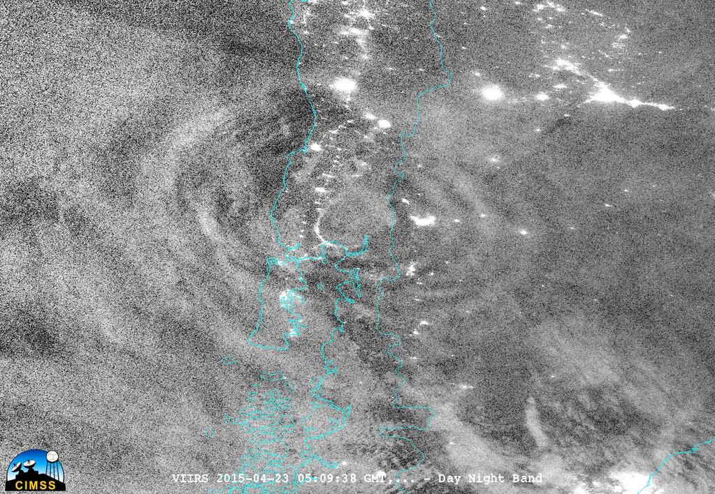
8 Day Night Band The DNB measures visible radiances from both the Earth and atmosphere Wavelength of 0.7 mm, 742m x 742m pixel size Receives visible data from via reflection and emission sources (natural and anthropogenic ) Stray light fix implemented August 21, 2013 Figure 1 from Lee et al (2005) McIDAS Users Group Meeting 8


9 Tongariro (New Zealand) August 6, Z Ash NASA Image 9 of the Day 9
")


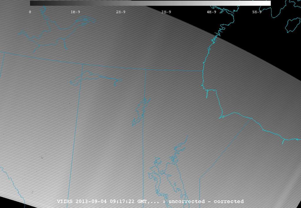
10 VIIRS (11, 3.9mm and DNB) 0733Z, July 15, 2012 Fires Winnipeg Aurora Chicago 2016 McIDAS Users Group Meeting 10

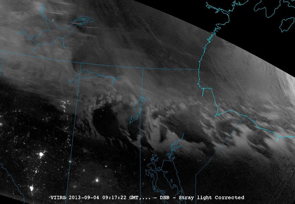
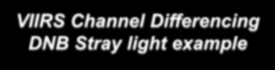
11 VIIRS Channel Differencing DNB Stray light example 2016 McIDAS Users Group Meeting 11


12 VIIRS SDR Ancillary data 2016 McIDAS Users Group Meeting 12
13 Visible Infrared Imaging Radiometer Suite (VIIRS) EDR There are a series of 20 Environmental Data Records (EDRs) produced from VIIRS McIDAS-V has been able to successfully ingest all EDRs including NDE Enterprise output McIDAS-V can unpack and display bit level data. Ex. Displaying VCM test results 13


14 VIIRS DNB and Surface temperature EDR 2236Z, 09/29/2012 Kampala Lake Albert Fog Kigali Mwanza Lake Victoria 14

15 Product EDR Variable selection 2016 McIDAS Users Group Meeting 15

16 Product EDR Data Probe 2016 McIDAS Users Group Meeting 16

17 Imagery EDR example 2016 McIDAS Users Group Meeting 17


18 S-NPP/JPSS specific McIDAS-V Status Expanded granule concatenation for SDRs and EDRs Support for both NASA and NOAA L1b formats Needed due to the move of the APEATE to NASA SIPS Works with Is able to easily load and manipulate Suomi NPP (Block 1 and 2) and JPSS-1 simulated Block 2 data without any special readers RGB Composite from NASA SIPS L1b 18

19 OTHER CIMSS SDR/EDR SUPPORT 2016 McIDAS Users Group Meeting 19


20 Oil sands Oil sands Fort McMurray 20

21 21
22 22

23 MCIDAS-X AND -V SUPPORT OF GOES-R ABI LEVEL 1B AND 2 PRODUCTS 2016 McIDAS Users Group Meeting 23
 Aerosol Detection (Including Smoke and Dust) Aerosol Optical Depth (AOD) Clear Sky Masks Cloud and Moisture Imagery Cloud Optical")

 Snow Cover Total Precipitable Water Volcanic Ash: Detection and Height # Lightning Lightning")

 Solar EUV Imagery Absorbed Shortwave Radiation: Surface Aerosol Particle Size Aircraft Icing Threat")


24 GOES-R Products Baseline Products Future Capabilities Advanced Baseline Imager (ABI) Geostationary Lightning Mapper (GLM) Advanced Baseline Imager (ABI) Aerosol Detection (Including Smoke and Dust) Aerosol Optical Depth (AOD) Clear Sky Masks Cloud and Moisture Imagery Cloud Optical Depth Cloud Particle Size Distribution Cloud Top Height Cloud Top Phase Cloud Top Pressure Cloud Top Temperature Derived Motion Winds Derived Stability Indices Downward Shortwave Radiation: Surface Fire/Hot Spot Characterization Hurricane Intensity Estimation Land Surface Temperature (Skin) Legacy Vertical Moisture Profile Legacy Vertical Temperature Profile # Radiances (ABI L1B) Rainfall Rate/QPE Reflected Shortwave Radiation: TOA Sea Surface Temperature (Skin) Snow Cover Total Precipitable Water Volcanic Ash: Detection and Height # Lightning Lightning Detection: Detection: Events, Events, Groups Groups & Flashes Flashes (L2+) Space Environment In-Situ Suite (SEISS) Energetic Heavy Ions Magnetospheric Electrons & Protons: Low Energy Magnetospheric Electrons: Med & High Energy Magnetospheric Protons: Med & High Energy Solar and Galactic Protons Magnetometer (MAG) Geomagnetic Field Extreme Ultraviolet and X-ray Irradiance Suite (EXIS) Solar Flux: EUV Solar Flux: X-ray Irradiance Solar Ultraviolet Imager (SUVI) Solar EUV Imagery Absorbed Shortwave Radiation: Surface Aerosol Particle Size Aircraft Icing Threat Cloud Ice Water Path Cloud Layers/Heights Cloud Liquid Water Cloud Type Convective Initiation Currents Currents: Offshore Downward Longwave Radiation: Surface Enhanced V /Overshooting Top Detection Flood/Standing Water Ice Cover Low Cloud and Fog Ozone Total Probability of Rainfall Rainfall Potential Sea and Lake Ice: Age Sea and Lake Ice: Concentration Sea and Lake Ice: Motion Snow Depth (Over Plains) SO 2 Detection Surface Albedo Surface Emissivity Tropopause Folding Turbulence Prediction Upward Longwave Radiation: Surface Upward Longwave Radiation: TOA Vegetation Fraction: Green Vegetation Index Visibility 24 24

 McIDAS-X display of")
25 McIDAS-X: Level 2 ABI Products McIDAS-X ADDE server in development for Level 2 ABI products is available in McIDAS-X (released Oct 2016) McIDAS-X display of Cloud Top Height

26 McIDAS-V: ABI Level 1B and L2+ McIDAS-V version 1.6 Both L1b and L2+ products can be read in directly using General file chooser Local L2+ ADDE file access will be added later Note : Linux and OSX versions of 1.6 have preliminary (limited) ABI L1b local ADDE server integrated in. McIDAS-V display Band 16

27 McIDAS-V: ABI Level 1B McIDAS-V display Band 2

28 McIDAS-V: Level 2 Products


29 McIDAS-V: DOE-4 Level 2 CAPE


30 Analysis tools McIDAS-V Time Series

31 Analysis tools McIDAS-V: Scatter Plot


32 Analysis tools McIDAS-V: Data Transect
33 McIDAS GOES-R Status Initial development complete: ABI Level 1B and limited L2 ADDE server available as part of release (Oct 2016) All servers are for GOES-R mission standard format netcdf files only. SCMI files are not supported. In development: GLM ADDE server (modifications are needed due to format change) Continued testing by teams (ex. Imagery team) of various servers
34 Uses of McIDAS for L2+ Products Post Launch Ability to quickly visualize the L2+ (ABI and GLM) Products (McX and McV) and produce images for presentations Note: McIDAS-X servers do not currently read in DQFs McIDAS-V has the ability to provide data analysis tools for teams (transects, simple scatter plots, time series) via ADDE servers 34

35 Launch time! Official L1b and L2+ Products available publically sometime
Operational Uses of Bands on the GOES-R Advanced Baseline Imager (ABI) Presented by: Kaba Bah
 Presented by: Kaba Bah") Operational Uses of Bands on the GOES-R Advanced Baseline Imager (ABI) Presented by: Kaba Bah Topics: Introduction to GOES-R & ABI ABI individual bands Use of band differences ABI derived products Conclusions
Operational Uses of Bands on the GOES-R Advanced Baseline Imager (ABI) Presented by: Kaba Bah Topics: Introduction to GOES-R & ABI ABI individual bands Use of band differences ABI derived products Conclusions
Future GOES (XGOHI, GOES-13/O/P, GOES-R+)
") Future GOES (XGOHI, GOES-13/O/P, GOES-R+) Timothy J. Schmit NOAA/NESDIS/Satellite Applications and Research Advanced Satellite Products Branch (ASPB) Madison, WI And many others MUG Meeting October 16,
Future GOES (XGOHI, GOES-13/O/P, GOES-R+) Timothy J. Schmit NOAA/NESDIS/Satellite Applications and Research Advanced Satellite Products Branch (ASPB) Madison, WI And many others MUG Meeting October 16,
Usage of McIDAS V with GOES R AWG products
 McIDAS User Group Meeting, October 25-27, 2010, Madison, WI Usage of McIDAS V with GOES R AWG products William Straka III UW/CIMSS Madison, Wisconsin, USA With help from Tom Rink (CIMSS/), Tom Achtor (CIMSS/),
Preparation for FY-4A. (Submitted by Xiang Fang, CMA)
") WORLD METEOROLOGICAL ORGANIZATION COMMISSION FOR BASIC SYSTEMS OPEN PROGRAMME AREA GROUP ON INTEGRATED OBSERVING SYSTEMS EXPERT TEAM ON SATELLITE UTILIZATION AND PRODUCTS ET-SUP-8/Doc. 10.3 (2.IV.2014)
WORLD METEOROLOGICAL ORGANIZATION COMMISSION FOR BASIC SYSTEMS OPEN PROGRAMME AREA GROUP ON INTEGRATED OBSERVING SYSTEMS EXPERT TEAM ON SATELLITE UTILIZATION AND PRODUCTS ET-SUP-8/Doc. 10.3 (2.IV.2014)
NOAA Operational Satellites -Program Update-
 NOAA Operational Satellites -Program Update- (GOES-R Series, JPSS & COSMIC-2) Briefing to the Expert Team on Satellite Systems (ET-SAT-11) Geneva, 4-6 April 2017 Sid Ahmed Boukabara NOAA/NESDIS Center
GOES-R. Getting ready for the next generation earth observing system. Yuguang He AER April 10, 2015
 GOES-R Getting ready for the next generation earth observing system Yuguang He AER April 10, 2015 Outline! AER in research and applica0ons! AER on GOES- R! GOES- R: the next genera0on! Ge:ng ready for
Interpretation of Polar-orbiting Satellite Observations. Atmospheric Instrumentation
 Interpretation of Polar-orbiting Satellite Observations Outline Polar-Orbiting Observations: Review of Polar-Orbiting Satellite Systems Overview of Currently Active Satellites / Sensors Overview of Sensor
Advanced Infrared Sounding System for Future Geostationary Satellites
 Advanced Infrared Sounding System for Future Geostationary Satellites Timothy J. Schmit @, Jun Li # Hal Bloom &, James J. Gurka & Jaime Daniels @, Mitch Goldberg @ Steve Ackerman #, Paul Menzel #, and
Joint Polar Satellite System. 3 rd Post-EPS User Consultation Workshop Mike Haas
 3 rd Post-EPS User Consultation Workshop Mike Haas Overview Introduction - Policy Drivers - Management System Description - Space Segment - Ground Segment Partnerships Status Benefits 2 Introduction (Policy
Recent Update on MODIS C6 and VIIRS Deep Blue Aerosol Products
 Recent Update on MODIS C6 and VIIRS Deep Blue Aerosol Products N. Christina Hsu, Photo taken from Space Shuttle: Fierce dust front over Libya Corey Bettenhausen, Andrew M. Sayer, and Rick Hansell Laboratory
Status report on the current and future satellite systems by CMA. Presented to CGMS46-CMA-WP-01, Plenary session, agenda item D.1
 Status report on the current and future satellite systems by CMA Presented to CGMS46-CMA-WP-01, Plenary session, agenda item D.1 Overview - Planning of CMA satellite systems FengYun Meteorological Satellites
JPSS GEONETCAST REQUIREMENTS DISCUSSION
 Joint Polar Satellite System (JPSS) JPSS GEONETCAST REQUIREMENTS DISCUSSION Mitch Goldberg Program Scientist Joint Polar Satellite System National Environmental Satellite, Data, and Information Service
Jun Park National Meteorological Satellite Center Korea Meteorological Administration
 KMA Implementation Plan for Satellite Climate products Jun Park National Meteorological Satellite Center Korea Meteorological Administration jun.park@kma.go.kr Outline 1. Introduction : Current & Future
Status of VIIRS Reflective Solar Bands On-orbit Calibration and Performance
 EOS Status of VIIRS Reflective Solar Bands On-orbit Calibration and Performance X. Xiong 1, J. Fulbright 2, N. Lei 2, J. Sun 2, Z. Wang 2, and J. McIntire 2 1. NASA/GSFC, Greenbelt, MD 20771, USA 2. Sigma
Application of Himawari-8 AHI Data to the GOES-R Rainfall Rate Algorithm
 Application of Himawari-8 AHI Data to the GOES-R Rainfall Rate Algorithm Yaping Li 1, Robert Kuligowski 2 and Yan Hao 1 1. IMSG at NOAA/NESDIS/STAR 2. NOAA/NESDIS/STAR, College Park, MD 1 GOES-R Baseline
Satellite observation of atmospheric dust
 Satellite observation of atmospheric dust Taichu Y. Tanaka Meteorological Research Institute, Japan Meteorological Agency 11 April 2017, SDS WAS: Dust observation and modeling @WMO, Geneva Dust observations
VALIDATION OF INSAT-3D DERIVED RAINFALL. (Submitted by Suman Goyal, IMD) Summary and Purpose of Document
 Summary and Purpose of Document") WORLD METEOROLOGICAL ORGANIZATION COMMISSION FOR BASIC SYSTEMS OPEN PROGRAMME AREA GROUP ON INTEGRATED OBSERVING SYSTEMS INTER-PROGRAMME EXPERT TEAM ON SATELLITE UTILIZATION AND PRODUCTS SECOND SESSION
WORLD METEOROLOGICAL ORGANIZATION COMMISSION FOR BASIC SYSTEMS OPEN PROGRAMME AREA GROUP ON INTEGRATED OBSERVING SYSTEMS INTER-PROGRAMME EXPERT TEAM ON SATELLITE UTILIZATION AND PRODUCTS SECOND SESSION
A 2016 CEOS Chair Initiative. Non-meteorological Applications for Next Generation Geostationary Satellites
 A 2016 CEOS Chair Initiative Committee on Earth Observation Satellites Non-meteorological Applications for Next Generation Geostationary Satellites Co-chaired by EUMETSAT (Holmlund), CSIRO (Schroeder),
Lecture 4b: Meteorological Satellites and Instruments. Acknowledgement: Dr. S. Kidder at Colorado State Univ.
 Lecture 4b: Meteorological Satellites and Instruments Acknowledgement: Dr. S. Kidder at Colorado State Univ. US Geostationary satellites - GOES (Geostationary Operational Environmental Satellites) US
REVISION OF THE STATEMENT OF GUIDANCE FOR GLOBAL NUMERICAL WEATHER PREDICTION. (Submitted by Dr. J. Eyre)
") WORLD METEOROLOGICAL ORGANIZATION Distr.: RESTRICTED CBS/OPAG-IOS (ODRRGOS-5)/Doc.5, Add.5 (11.VI.2002) COMMISSION FOR BASIC SYSTEMS OPEN PROGRAMME AREA GROUP ON INTEGRATED OBSERVING SYSTEMS ITEM: 4 EXPERT
WORLD METEOROLOGICAL ORGANIZATION Distr.: RESTRICTED CBS/OPAG-IOS (ODRRGOS-5)/Doc.5, Add.5 (11.VI.2002) COMMISSION FOR BASIC SYSTEMS OPEN PROGRAMME AREA GROUP ON INTEGRATED OBSERVING SYSTEMS ITEM: 4 EXPERT
F O U N D A T I O N A L C O U R S E
 F O U N D A T I O N A L C O U R S E December 6, 2018 Satellite Foundational Course for JPSS (SatFC-J) F O U N D A T I O N A L C O U R S E Introduction to Microwave Remote Sensing (with a focus on passive
Joint Polar Satellite System (JPSS)
") Joint Polar Satellite System (JPSS) United States Plans for Continuity of Operational Polar Weather and Environmental Observations Harry Cikanek, Director Mitch Goldberg, Program Scientist Joint Polar
Joint Polar Satellite System (JPSS) United States Plans for Continuity of Operational Polar Weather and Environmental Observations Harry Cikanek, Director Mitch Goldberg, Program Scientist Joint Polar
ABI and AIRS Retrievals in McIDAS-V
 ABI and AIRS Retrievals in McIDAS-V Kaba Bah Content Introduction to McIDAS V Introduction to GOES R ABI Visualize simulated ABI using McIDAS V Analyze simulated ABI using McIDAS V Introduction to AIRS
EPS-SG Candidate Observation Missions
 EPS-SG Candidate Observation Missions 3 rd Post-EPS User Consultation Workshop Peter Schlüssel Slide: 1 EPS-SG benefits to activities of NMSs Main Payload High-Resolution Infrared Sounding Microwave Sounding
NESDIS Polar (Region) Products and Plans. Jeff Key NOAA/NESDIS Madison, Wisconsin USA
 Products and Plans. Jeff Key NOAA/NESDIS Madison, Wisconsin USA") NESDIS Polar (Region) Products and Plans Jeff Key NOAA/NESDIS Madison, Wisconsin USA WMO Polar Space Task Group, 2 nd meeting, Geneva, 12 14 June 2012 Relevant Missions and Products GOES R ABI Fractional
NESDIS Polar (Region) Products and Plans Jeff Key NOAA/NESDIS Madison, Wisconsin USA WMO Polar Space Task Group, 2 nd meeting, Geneva, 12 14 June 2012 Relevant Missions and Products GOES R ABI Fractional
NOAA Cal/Val Progress Update
 NOAA Cal/Val Progress Update Xi Shao 1,2 and Changyong Cao 2 1. University of Maryland 2. NOAA/NESDIS/STAR With contributions from NOAA/NESDIS/STAR Scientists Presented at the WGCV-36, Shanghai, China,
History of Aerosol Remote Sensing. Mark Smithgall Maria Zatko 597K Spring 2009
 History of Aerosol Remote Sensing Mark Smithgall Maria Zatko 597K Spring 2009 Aerosol Sources Anthropogenic Biological decomposition from fertilizer and sewage treatment (ex. ammonium) Combustion of fossil
Preparing for NOAA s Next Generation GOES-R & JPSS
 Preparing for NOAA s Next Generation GOES-R & JPSS Mark Paese Deputy Assistant Administrator NOAA Environmental Satellite & Information Service (NESDIS) WMO Cg-17: Ensuring User Readiness for New Generation
APPLICATIONS WITH METEOROLOGICAL SATELLITES. W. Paul Menzel. Office of Research and Applications NOAA/NESDIS University of Wisconsin Madison, WI
 APPLICATIONS WITH METEOROLOGICAL SATELLITES by W. Paul Menzel Office of Research and Applications NOAA/NESDIS University of Wisconsin Madison, WI July 2004 Unpublished Work Copyright Pending TABLE OF CONTENTS
CLAVR-x is the Clouds from AVHRR Extended Processing System. Responsible for AVHRR cloud products and other products at various times.
 CLAVR-x in CSPP Andrew Heidinger, NOAA/NESDIS/STAR, Madison WI Nick Bearson, SSEC, Madison, WI Denis Botambekov, CIMSS, Madison, WI Andi Walther, CIMSS, Madison, WI William Straka III, CIMSS, Madison,
Instrumentation planned for MetOp-SG
 Instrumentation planned for MetOp-SG Bill Bell Satellite Radiance Assimilation Group Met Office Crown copyright Met Office Outline Background - the MetOp-SG programme The MetOp-SG instruments Summary Acknowledgements:
Direct Readout at the Meteorological Service of Canada
 Direct Readout at the Meteorological Service of Canada CSPP Users Meeting 2015 Darmstadt, Germany April 14-16, 2015 David Bradley Manager, Earth Observation and Geomatics Meteorological Service of Canada
GOES-16 & GOES-S: Natalia Donoho. Preparing Users for New Generation Satellites. WMO IPET-SUP-4 Geneva, Switzerland 26 February, 2018
 GOES-16 & GOES-S: Preparing Users for New Generation Satellites Natalia Donoho Satellite Products and Services Division (NOAA/NESDIS) WMO IPET-SUP-4 Geneva, Switzerland 26 February, 2018 GOES-R series
Remote Sensing in Meteorology: Satellites and Radar. AT 351 Lab 10 April 2, Remote Sensing
 Remote Sensing in Meteorology: Satellites and Radar AT 351 Lab 10 April 2, 2008 Remote Sensing Remote sensing is gathering information about something without being in physical contact with it typically
JPSS Overview.
 JPSS Overview Mitch Goldberg, JPSS Program Scientist Joint Polar Satellite System National Environmental Satellite, Data, and Information Service National Oceanic and Atmospheric Administration September
GOES-R Overview and Status
 GOES-R Overview and Status Tom Renkevens NOAA s Satellite and Information Service McIDAS Users Group 2005 October 27, 2005 1 Outline Purpose GOES Background Requirements Instrument Summary Notional Architecture
Lecture 19: Operational Remote Sensing in Visible, IR, and Microwave Channels
 MET 4994 Remote Sensing: Radar and Satellite Meteorology MET 5994 Remote Sensing in Meteorology Lecture 19: Operational Remote Sensing in Visible, IR, and Microwave Channels Before you use data from any
Plans for NOAA s GOES-R Series Satellites
 Plans for NOAA s GOES-R Series Satellites G. Dittberner, E. Miller, M. Madden, and B. Nelson NOAA Satellite and Information Service 1315 East West Highway, Silver Spring, MD 20910 ABSTRACT NOAA s next
CGMS Baseline. Sustained contributions to the Global Observing System. Endorsed by CGMS-46 in Bengaluru, June 2018
 CGMS Baseline Sustained contributions to the Global Observing System Best Practices for Achieving User Readiness for New Meteorological Satellites Endorsed by CGMS-46 in Bengaluru, June 2018 CGMS/DOC/18/1028862,
The Transition of Atmospheric Infrared Sounder Total Ozone Products to Operations
 The Transition of Atmospheric Infrared Sounder Total Ozone Products to Operations Emily Berndt 1, Bradley Zavodsky 2, Gary Jedlovec 2 1 NASA Postdoctoral Program Marshall Space Flight Center, Huntsville,
The current status of FY-3D
 The current status of FY-3D Xiang Fang National Satellite Meteorological Center, China Meteorological Administration (NSMC/CMA) OUTLINE Overview Key instruments onboard FY-3D Products and data service
CGMS Baseline In response to CGMS action/recommendation A45.01 HLPP reference: 1.1.8
 Prepared by WGIII Agenda Item: 7.1 Discussed in WGIII CGMS Baseline In response to CGMS action/recommendation A45.01 HLPP reference: 1.1.8 In CGMS-45, Working Group III agreed to hold a review of the CGMS
Assessment of AHI Level-1 Data for HWRF Assimilation
 Assessment of AHI Level-1 Data for HWRF Assimilation Xiaolei Zou 1 and Fuzhong Weng 2 1 Earth System Science Interdisciplinary Center, University of Maryland, College Park, Maryland 2 Satellite Meteorology
JPSS. Suomi NPP* satellite, JPSS-1 satellite, and JPSS-2 satellite Four primary instruments (ATMS, CrIS, VIIRS, OMPS)
") Operational and Research Applications from the Joint Polar Satellite System (JPSS) Nove be 200 2014 0 November AOMSUC-5 Mitch Goldberg, JPSS Program Scientist Presented by: Lihang Zhou, JPSS STAR (JSTAR)
Operational and Research Applications from the Joint Polar Satellite System (JPSS) Nove be 200 2014 0 November AOMSUC-5 Mitch Goldberg, JPSS Program Scientist Presented by: Lihang Zhou, JPSS STAR (JSTAR)
Observations Team: Satellite Observation Update. John Knaff NOAA/NESDIS Regional and Mesoscale Meteorology Branch
 Observations Team: Satellite Observation Update John Knaff NOAA/NESDIS Regional and Mesoscale Meteorology Branch 1 FY12 Satellite Milestones: i. CIRA/RAMMB continue maintaining and populating real-time
Improving Tropical Cyclone Forecasts by Assimilating Microwave Sounder Cloud-Screened Radiances and GPM precipitation measurements
 Improving Tropical Cyclone Forecasts by Assimilating Microwave Sounder Cloud-Screened Radiances and GPM precipitation measurements Hyojin Han a, Jun Li a, Mitch Goldberg b, Pei Wang a,c, Jinlong Li a,
Impact of assimilating the VIIRS-based CrIS cloudcleared radiances on hurricane forecasts
 Impact of assimilating the VIIRS-based CrIS cloudcleared radiances on hurricane forecasts Jun Li @, Pei Wang @, Jinlong Li @, Zhenglong Li @, Jung-Rim Lee &, Agnes Lim @, Timothy J. Schmit #, and Mitch
Himawari-8 True Color RGB
 Himawari-8 True Color RGB Meteorological Satellite Center, JMA Ver. 20150519 What s True Color RGB? R : B03(VS 0.64) G : B02(V2 0.51) 2015-03-17 00UTC B : B01(V1 0.46) Components of True Color RGB Channel
IDEA. from research to routine
 IDEA. from research to routine A collaboration between NASA, EPA, NOAA and CIMSS Cooperative Institute for Meteorological Satellite Studies Infusing satellite Data in Environmental Applications (IDEA)
Himawari-8/9 and GCOM-C Non-Meteorological Application Opportunities
 Himawari-8/9 and GCOM-C Non-Meteorological Application Opportunities Alex Held Centre for Australian Weather and Climate Research CAWCR December 2013 Selected materials from C. Down BoM) Non-Meteorological
Projects in the Remote Sensing of Aerosols with focus on Air Quality
 Projects in the Remote Sensing of Aerosols with focus on Air Quality Faculty Leads Barry Gross (Satellite Remote Sensing), Fred Moshary (Lidar) Direct Supervision Post-Doc Yonghua Wu (Lidar) PhD Student
GOES-R. Steve Goodman. GOES-R Program Senior Scientist. The Nation s Next- Generation Geostationary Weather Satellites
 GOES-R The Nation s Next- Generation Geostationary Weather Satellites Steve Goodman GOES-R Program Senior Scientist National Academy of Science Space Studies Board Spring Meeting Washington, DC May 4,
Xiang FNAG National Satellite Meteorological Center, China Meteorological Administration (NSMC/CMA)
") CMA Fengyun Meteorological Satellite Program Xiang FNAG National Satellite Meteorological Center, China Meteorological Administration (NSMC/CMA) Outline Overview Current Missions Latest Progress Future
CMA Fengyun Meteorological Satellite Program Xiang FNAG National Satellite Meteorological Center, China Meteorological Administration (NSMC/CMA) Outline Overview Current Missions Latest Progress Future
Jun Mitch Goldberg %, Pei Timothy J. Schmit &, Jinlong Zhenglong and Agnes
 Progress on the assimilation of advanced IR sounder radiances in cloudy skies Jun Li @, Mitch Goldberg %, Pei Wang @#, Timothy J. Schmit &, Jinlong Li @, Zhenglong Li @, and Agnes Lim @ @CIMSS, University
Preparation for Himawari 8
 Preparation for Himawari 8 Japan Meteorological Agency Meteorological Satellite Center Hidehiko MURATA ET SUP 8, WMO HQ, Geneva, 14 17 April 2014 1/18 Introduction Background The Japan Meteorological Agency
Arising from headwaters around Mount Robson in the Rocky Mountains, the Fraser River starts as a fastmoving stream. The river angles northward around
 Arising from headwaters around Mount Robson in the Rocky Mountains, the Fraser River starts as a fastmoving stream. The river angles northward around the Columbia Mountains, picking up so much sediment
Non-meteorological Applications for Next Generation Geostationary Meteorological Satellites
 Non-meteorological Applications for Next Generation Geostationary Meteorological Satellites Toshiyuki KURINO Satellite Program Division Japan Meteorological Agency Topics Advanced GEO for Earth Observation
On the assimilation of hyperspectral infrared sounder radiances in cloudy skies
 On the assimilation of hyperspectral infrared sounder radiances in cloudy skies Jun Li 1, Pei Wang 1, Zhenglong Li 1, Jinlong Li 1 and Mitchell D. Goldberg 2 1 Cooperative Institute for Meteorological
GOES-R Instrument Status and Accommodations. Barbara Pfarr GOES-R Program Systems Engineering January 2010 AMS Conference
 GOES-R Instrument Status and Accommodations Barbara Pfarr GOES-R Program Systems Engineering January 2010 AMS Conference Agenda Instrument Developmental Status Significant Changes in the Last Year Introducing
Sensitivity Study of the MODIS Cloud Top Property
 Sensitivity Study of the MODIS Cloud Top Property Algorithm to CO 2 Spectral Response Functions Hong Zhang a*, Richard Frey a and Paul Menzel b a Cooperative Institute for Meteorological Satellite Studies,
McIDAS Activities Within The NASA Langley Research Center Clouds And Radiation Group
 McIDAS Activities Within The NASA Langley Research Center Clouds And Radiation Group Kristopher Bedka Science Systems and Applications Inc @ NASA LaRC In Collaboration With (in alphabetical order) J. K.
NOAA Report. Hal Bloom Mitch Goldberg NOAA/NESDIS
 NOAA Report Hal Bloom Mitch Goldberg NOAA/NESDIS Summary of Major Events at NESDIS (of interest to ITSC) NOAA/NASA addressing NPOESS Climate Sensors Letter of agreement signed with JAXA on GCOM interagency
Introduction of the Hyperspectral Environmental Suite (HES) on GOES-R and beyond
 on GOES-R and beyond") Introduction of the Hyperspectral Environmental Suite (HES) on GOES-R and beyond Timothy J. Schmit SaTellite Applications and Research (STAR) Advanced Satellite Products Team (ASPT) Presented by Jun Li
Introduction of the Hyperspectral Environmental Suite (HES) on GOES-R and beyond Timothy J. Schmit SaTellite Applications and Research (STAR) Advanced Satellite Products Team (ASPT) Presented by Jun Li
Extending the Deep Blue aerosol record from SeaWiFS and MODIS to NPP-VIIRS
 Extending the Deep Blue aerosol record from SeaWiFS and MODIS to NPP-VIIRS Andrew M. Sayer, N. Christina Hsu (PI), Corey Bettenhausen, Jaehwa Lee Climate & Radiation Laboratory, NASA Goddard Space Flight
METEOSAT THIRD GENERATION
 METEOSAT THIRD GENERATION FACTS AND FIGURES MONITORING WEATHER AND CLIMATE FROM SPACE A HIGHLY INNOVATIVE GEOSTATIONARY SATELLITE SYSTEM FOR EUROPE AND AFRICA The Meteosat Third Generation (MTG) system
WMO Aeronautical Meteorology Scientific Conference 2017
 Session 1 Science underpinning meteorological observations, forecasts, advisories and warnings 1.6 Observation, nowcast and forecast of future needs 1.6.1 Advances in observing methods and use of observations
FUTURE PLAN AND RECENT ACTIVITIES FOR THE JAPANESE FOLLOW-ON GEOSTATIONARY METEOROLOGICAL SATELLITE HIMAWARI-8/9
 FUTURE PLAN AND RECENT ACTIVITIES FOR THE JAPANESE FOLLOW-ON GEOSTATIONARY METEOROLOGICAL SATELLITE HIMAWARI-8/9 Toshiyuki Kurino Japan Meteorological Agency, 1-3-4 Otemachi Chiyodaku, Tokyo 100-8122,
1. The frequency of an electromagnetic wave is proportional to its wavelength. a. directly *b. inversely
 CHAPTER 3 SOLAR AND TERRESTRIAL RADIATION MULTIPLE CHOICE QUESTIONS 1. The frequency of an electromagnetic wave is proportional to its wavelength. a. directly *b. inversely 2. is the distance between successive
Introducing VIIRS Aerosol Products
 1 Introducing VIIRS Aerosol Products Shobha Kondragunta NOAA/NESDIS Center for Satellite Applications and Research VIIRS Aerosol Cal/Val Team 2 Name Organization Major Task Kurt F. Brueske IIS/Raytheon
How to display RGB imagery by SATAID
 How to display RGB imagery by SATAID Akihiro SHIMIZU Meteorological Satellite Center (MSC), Japan Meteorological Agency (JMA) Ver. 2015110500 RGB imagery on SATAID SATAID software has a function of overlapping
Current status of GK-2A AMV algorithm in NMSC/KMA
 Current status of GK-2A AMV algorithm in NMSC/KMA 23 April 2018 Soo Min Oh, Byung-il Lee, Sung-Rae Chung, Seonkyun Baek NMSC/KMA 국가기상위성센터 National Meteorological Satellite Center Contents Status of COMS
Report on CIMSS Participation in the Utility of GOES-R Instruments for Hurricane Data Assimilation and Forecasting
 Report on CIMSS Participation in the Utility of GOES-R Instruments for Hurricane Data Assimilation and Forecasting Award Number: NA10NES4400010 Award Period: 06/01/2010-05/31/2014 Program Office: NESDIS
VIIRS SDR Cal/Val: S-NPP Update and JPSS-1 Preparations
 VIIRS SDR Cal/Val: S-NPP Update and JPSS-1 Preparations VIIRS SDR Cal/Val Posters: Xi Shao Zhuo Wang Slawomir Blonski ESSIC/CICS, University of Maryland, College Park NOAA/NESDIS/STAR Affiliate Spectral
P3.24 EVALUATION OF MODERATE-RESOLUTION IMAGING SPECTRORADIOMETER (MODIS) SHORTWAVE INFRARED BANDS FOR OPTIMUM NIGHTTIME FOG DETECTION
 SHORTWAVE INFRARED BANDS FOR OPTIMUM NIGHTTIME FOG DETECTION") P3.24 EVALUATION OF MODERATE-RESOLUTION IMAGING SPECTRORADIOMETER (MODIS) SHORTWAVE INFRARED BANDS FOR OPTIMUM NIGHTTIME FOG DETECTION 1. INTRODUCTION Gary P. Ellrod * NOAA/NESDIS/ORA Camp Springs, MD
P3.24 EVALUATION OF MODERATE-RESOLUTION IMAGING SPECTRORADIOMETER (MODIS) SHORTWAVE INFRARED BANDS FOR OPTIMUM NIGHTTIME FOG DETECTION 1. INTRODUCTION Gary P. Ellrod * NOAA/NESDIS/ORA Camp Springs, MD
Tracking On-orbit Radiometric Accuracy and Stability of Suomi NPP VIIRS using Extended Low Latitude SNOs
 Tracking On-orbit Radiometric Accuracy and Stability of Suomi NPP VIIRS using Extended Low Latitude SNOs Sirish Uprety a Changyong Cao b Slawomir Blonski c Xi Shao c Frank Padula d a CIRA, Colorado State
Feature-tracked 3D Winds from Satellite Sounders: Derivation and Impact in Global Models
 Feature-tracked 3D Winds from Satellite Sounders: Derivation and Impact in Global Models David Santek, Anne-Sophie Daloz 1, Samantha Tushaus 1, Marek Rogal 1, Will McCarty 2 1 Space Science and Engineering
Once a specific data set is selected, NEO will list related data sets in the panel titled Matching Datasets, which is to the right of the image.
 NASA Earth Observations (NEO): A Brief Introduction NEO is a data visualization tool that allows users to explore a wealth of environmental data collected by NASA satellites. The satellites use an array
CLOUD CLASSIFICATION AND CLOUD PROPERTY RETRIEVAL FROM MODIS AND AIRS
 6.4 CLOUD CLASSIFICATION AND CLOUD PROPERTY RETRIEVAL FROM MODIS AND AIRS Jun Li *, W. Paul Menzel @, Timothy, J. Schmit @, Zhenglong Li *, and James Gurka # *Cooperative Institute for Meteorological Satellite
EUMETSAT atmospheric composition products and support to CAMS
 EUMETSAT atmospheric composition products and support to CAMS C. Retscher, R. Munro, R. Lang, R. Lindstrot, G. Poli, R. Huckle, N. Hao, S. Gimeno Garcia, A. Cacciari, A. Holdak, A. Kokhanovsky EUMETSAT
The current status of FY-3D. (Submitted by Xiang Fang, CMA) Summary and Purpose of Document
 Summary and Purpose of Document") WORLD METEOROLOGICAL ORGANIZATION COMMISSION FOR BASIC SYSTEMS OPEN PROGRAMME AREA GROUP ON INTEGRATED OBSERVING SYSTEMS INTER-PROGRAMME EXPERT TEAM ON SATELLITE UTILIZATION AND PRODUCTS FOURTH SESSION
WORLD METEOROLOGICAL ORGANIZATION COMMISSION FOR BASIC SYSTEMS OPEN PROGRAMME AREA GROUP ON INTEGRATED OBSERVING SYSTEMS INTER-PROGRAMME EXPERT TEAM ON SATELLITE UTILIZATION AND PRODUCTS FOURTH SESSION
Status of Operational Suomi NPP Algorithms. Bonnie Reed JPSS Ground Project Data Products and Algorithms
 Status of Operational Suomi NPP Algorithms Bonnie Reed JPSS Ground Project Data Products and Algorithms Outline Overview of SNPP Data Products Algorithm Validation Process Algorithm Status Algorithm Maturity
GIFTS SOUNDING RETRIEVAL ALGORITHM DEVELOPMENT
 P2.32 GIFTS SOUNDING RETRIEVAL ALGORITHM DEVELOPMENT Jun Li, Fengying Sun, Suzanne Seemann, Elisabeth Weisz, and Hung-Lung Huang Cooperative Institute for Meteorological Satellite Studies (CIMSS) University
Introduction of the Hyperspectral Environmental Suite (HES) on GOES-R and beyond
 on GOES-R and beyond") Introduction of the Hyperspectral Environmental Suite (HES) on GOES-R and beyond 1 Timothy J. Schmit, 2 Jun Li, 3 James Gurka 1 NOAA/NESDIS, Office of Research and Applications, Advanced Satellite Products
Introduction of the Hyperspectral Environmental Suite (HES) on GOES-R and beyond 1 Timothy J. Schmit, 2 Jun Li, 3 James Gurka 1 NOAA/NESDIS, Office of Research and Applications, Advanced Satellite Products
Some NOAA Products that Address PSTG Satellite Observing Requirements. Jeff Key NOAA/NESDIS Madison, Wisconsin USA
 Some NOAA Products that Address PSTG Satellite Observing Requirements Jeff Key NOAA/NESDIS Madison, Wisconsin USA WMO Polar Space Task Group, 4 th meeting, Greenbelt, 30 September 2014 Relevant Missions
DERIVING ATMOSPHERIC MOTION VECTORS FROM AIRS MOISTURE RETRIEVAL DATA
 DERIVING ATMOSPHERIC MOTION VECTORS FROM AIRS MOISTURE RETRIEVAL DATA David Santek 1, Sharon Nebuda 1, Christopher Velden 1, Jeff Key 2, Dave Stettner 1 1 Cooperative Institute for Meteorological Satellite
4.1 New Generation Satellite Data and Nowcasting Products: Himawari
 4.1 New Generation Satellite Data and Nowcasting Products: Himawari SCOPE-Nowcasting-EP 18-20 September 2017 Koji Yamashita kobo.yamashita@met.kishou.go.jp Meteorological Satellite Center (MSC) Japan Meteorological
The NOAA Unique CrIS/ATMS Processing System (NUCAPS): first light retrieval results
: first light retrieval results") The NOAA Unique CrIS/ATMS Processing System (NUCAPS): first light retrieval results A. Gambacorta (1), C. Barnet (2), W.Wolf (2), M. Goldberg (2), T. King (1), X. Ziong (1), N. Nalli (3), E. Maddy (1),
The NOAA Unique CrIS/ATMS Processing System (NUCAPS): first light retrieval results A. Gambacorta (1), C. Barnet (2), W.Wolf (2), M. Goldberg (2), T. King (1), X. Ziong (1), N. Nalli (3), E. Maddy (1),
GLM INR and Instrument Performance Evaluation
 GLM INR and Instrument Performance Evaluation Presented by Dennis Buechler University of Alabama in Huntsville Joint MTG LI Mission Advisory Group & GOES-R GLM Science Team Workshop, Rome Italy 27-29 May
Status of S-NPP VIIRS Solar and Lunar Calibration
 Status of S-NPP VIIRS Solar and Lunar Calibration X. Xiong 1, N. Lei 2, J. Fulbright 2, and Z. Wang 2 1 NASA Goddard Space Flight Center, Greenbelt, MD 20771, USA 2 Science Systems and Applications Inc.,
OSI SAF SST Products and Services
 OSI SAF SST Products and Services Pierre Le Borgne Météo-France/DP/CMS (With G. Legendre, A. Marsouin, S. Péré, S. Philippe, H. Roquet) 2 Outline Satellite IR radiometric measurements From Brightness Temperatures
Overview on GK-2A Data and Products
 SCOPE-Nowcasting EP-1 Overview on GK-2A Data and Products Jae-Dong Jang NMSC Geo-KOMPSAT-2A, AMI Sector Satellite in Orbit Operator Location Launch date Environmental payload and status GEO-KOMPSAT-2A
Day Microphysics RGB Nephanalysis in daytime. Meteorological Satellite Center, JMA
 Day Microphysics RGB Nephanalysis in daytime Meteorological Satellite Center, JMA What s Day Microphysics RGB? R : B04 (N1 0.86) Range : 0~100 [%] Gamma : 1.0 G : B07(I4 3.9) (Solar component) Range :
Lectures 7 and 8: 14, 16 Oct Sea Surface Temperature
 Lectures 7 and 8: 14, 16 Oct 2008 Sea Surface Temperature References: Martin, S., 2004, An Introduction to Ocean Remote Sensing, Cambridge University Press, 454 pp. Chapter 7. Robinson, I. S., 2004, Measuring
Topics: Visible & Infrared Measurement Principal Radiation and the Planck Function Infrared Radiative Transfer Equation
 Review of Remote Sensing Fundamentals Allen Huang Cooperative Institute for Meteorological Satellite Studies Space Science & Engineering Center University of Wisconsin-Madison, USA Topics: Visible & Infrared
Study of the Influence of Thin Cirrus Clouds on Satellite Radiances Using Raman Lidar and GOES Data
 Study of the Influence of Thin Cirrus Clouds on Satellite Radiances Using Raman Lidar and GOES Data D. N. Whiteman, D. O C. Starr, and G. Schwemmer National Aeronautics and Space Administration Goddard
Overview: Scope and Goals
 Overview: Scope and Goals Current operational NOAA instruments: AVHRR, HIRS, SBUV, GOES Imagers/Sounders; Non-NOAA satellites/sensors; Future: MetOP and NPP/NPOESS; GOES-R Assure Functionality of Current/Near-Future
CSPP Geo. CSPP/IMAPP Users Group Meeting 2015 Darmstadt, Germany 15 April 2015
 CSPP Geo Graeme Martin, Liam Gumley, Nick Bearson, Jessica Braun, Geoff Cureton, Ray Garcia, Tommy Jasmin, Scott Mindock, Kathy Strabala University of Wisconsin Madison, Space Science & Engineering Center
Remote Sensing of Precipitation
 Lecture Notes Prepared by Prof. J. Francis Spring 2003 Remote Sensing of Precipitation Primary reference: Chapter 9 of KVH I. Motivation -- why do we need to measure precipitation with remote sensing instruments?
Land Surface Temperature Measurements From the Split Window Channels of the NOAA 7 Advanced Very High Resolution Radiometer John C.
 Land Surface Temperature Measurements From the Split Window Channels of the NOAA 7 Advanced Very High Resolution Radiometer John C. Price Published in the Journal of Geophysical Research, 1984 Presented
Seeking a consistent view of energy and water flows through the climate system
 Seeking a consistent view of energy and water flows through the climate system Robert Pincus University of Colorado and NOAA/Earth System Research Lab Atmospheric Energy Balance [Wm -2 ] 340.1±0.1 97-101