Launched on May 4, K. Hokusai
|
|
|
- Mary French
- 5 years ago
- Views:
Transcription
, D. TANRE, J.")
1 CITES-2009 CITES-2009 CONFERENCE CONFERENCE KRASNOYARSK, KRASNOYARSK, Russia Russia OBSERVING THE EARTH FROM SPACE AS AN INTEGRATED SYSTEM: THE USA/F* A-TRAIN CONCEPT G. BEGNI, D. RENAUT (CNES CNES), D. TANRE, J.PELON (CNRS CNRS) * With contributions of Canada, Brazil and Netherlands 1
2 RAISING THE CURTAIN THE A-TRAIN ORIGINAL CONCEPT (1) The "A-Train" satellite formation consists of seven satellites flying in close proximity : Aqua, Aura, CloudSAT, CALIPSO, PARASOL, OCO, GLORY. They cross the equator within a few minutes of one another at around 1:30 p.m. local time. By combining information observed almost simultaneously from several sources, scientists can obtain comprehensive information to better understand important parameters related to climate change. 2
3 RAISING THE CURTAIN THE A-TRAIN ORIGINAL CONCEPT (2) 3
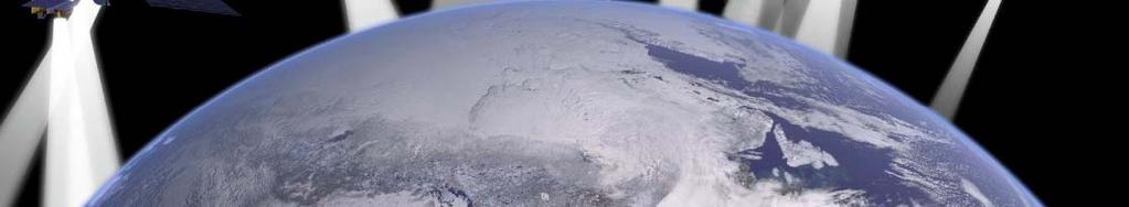
4 AQUA Launched on May 4, 2002 K. Hokusai 4
5 THE AQUA MISSION Aqua mission => to collect a large amount of information about the Earth's water cycle, including evaporation from the oceans, water vapour in the atmosphere, clouds, precipitation, soil moisture, sea ice, land ice, and snow cover on the land and ice. Additional variables measured by Aqua : radiative energy fluxes, aerosols, vegetation cover on the land, phytoplankton & dissolved organic matter in the oceans, and air, land, & water temperatures. 5
6 THE SIX AQUA INSTRUMENTS (1) AIRS, (Atmospheric Infrared Sounder) - an advanced sounder infrared channels & 4 visible/near-infrared channels, => highly accurate atmosphere temperature profiles & a variety of additional Earth/atmosphere products. Accuracy: 1 K temperature per 1 km layer in the troposphere. AMSU-A (Advanced Microwave Sounding Unit) - a 15-channel microwave sounder => obtain temperature t profiles in the upper atmosphere (especially the stratosphere) & provide a cloud-filtering capability for tropospheric temperature observations HSB (Humidity Sounder for Brazil) - a 4-channel microwave sounder provided by Brazil aimed at obtaining humidity profiles throughout the atmosphere even under conditions of heavy cloudiness and haze. Nadir Spatial Resolution 13.5 km => AIRS : flagship instrument in this triplet centered on measuring accurate temperature and humidity profiles throughout the atmosphere. 6
7 THE SIX AQUA INSTRUMENTS (2) MODIS (already on bord TERRA) TERRA & AQUA MODIS are viewing the entire Earth's surfaceevery every 1 to 2 days - 36 spectral bands or groups (0.4 µm to 14.4 µm) 250 m to 1 km ground resolution. Two CERES (Cloud and Earth Radiant Energy System) - already on board TERRA) - a 3-channel radiometer measuring reflected solar radiation (0.3-5 µm) emitted terrestrial radiation (8-12 µm) and total radiation (from 0.3 µm to beyond 100 µm). => measure the Earth's total thermal radiation budget, and, in combination with MODIS data,, detailed information about clouds (nadir spatial resolution: 20 km). AMSR (Advanced Microwave Scanning Radiometer) - a 12 channel, six-frequency passive-microwave radiometer system. Measures brightness temperatures at 6.925, 10.65, 18.7, 23.8, , and 89.0 GHz - 55 scan angle.

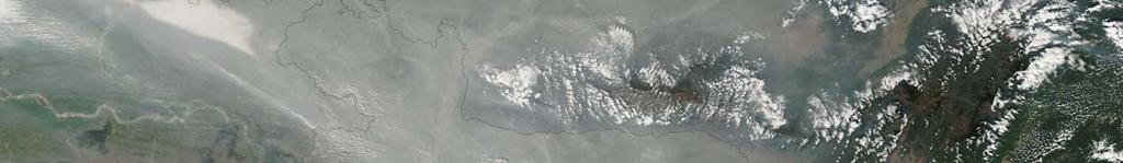
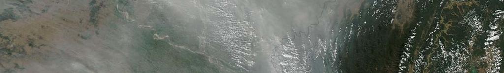
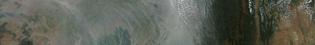
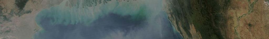
8 A MODIS/AQUA IMAGE Haze concentrated over Bangladesh on January 20,


9 AURA Launched on July 15, Ozone Hole Maximum on 2008 as evidenced by AURA, Sept. 12, 2008 NASA
10 AURA The AURA mission is to conduct research on the composition, chemistry and dynamics of the Earth s atmosphere. Main targets: Ozone, air quality & climate. Four instruments are implemented on board to reach this objective. 10
11 AURA INSTRUMENTS (1) HIRDLS : Scanning infrared limb sounder - Observes global distribution of temperature and concentrations of O3, H2O, CH4, N2O, NO2, HNO3, N2O5, CFC11, CFC12, ClONO2, and aerosols in the upper troposphere, p stratosphere, and mesosphere. MLS : Passive microwave limb-sounding radiometer /spectrometer ( millimeter and sub-millimeter) (1) stratospheric temperature and upper tropospheric constituents t that t play an important t role in stratospheric t chemistry (OH, HO2, BrO) (2) (2) upper tropospheric water vapor even in the presence of tropical cirrus, & cirrus ice content. 11
12 AURA INSTRUMENTS (2) OMI (contribution of Netherlands): hyperspectral imager to observe solar backscatter radiation in the visible and ultraviolet. Can distinguish between aerosol types, measure cloud pressure & coverage and such components as NO2, SO2, BrO, OClO => derive tropospheric ozone. TES: : high-resolution infrared-imaging imaging Fourier transform spectrometer => discrimination of most radiatively active molecular species in the Earth's lower atmosphere. Day- night coverage anywhere on the globe. Operates in a combination of limb and nadir mode. 12
13 Example: S02 concentration derived by AURA/OMI SO2 Plume from Nyamuragira Volcano (OMI SO2 Amount: avg Nov 28- Dec 4, 2006) P.I: Nikolay Krotkov & Arlin Krueger (NASA GSFC / UMBC) 13
14 CALIPSO Launched on April, 2006 V. Van Gogh 14
15 CALIPSO PHYSICS (1) CALIPSO combines CALIOP,, an active retro-diffusion lidar instrument (532 nm & 1064 nm ; polarized reception ; 20 Hz ; 1 meter diameter telescope ; 30 m vertical resolution; 333m horizontal resolution) with passive infrared (8.65 µm, 10.6 µm & µm; 125m /1 km ground resolution) and visible (645 nm; 125 m ground resolution) imagers) => to probe the vertical structure and properties of thin clouds and aerosols over the globe. 15
16 CALIPSO PHYSICS (2) Retro-diffusion lidar => information about height and thickness of the clouds and aerosols layers in the atmosphere => size, shape (spherical or not) and composition (ice/water) of particles. 16
17 CLOUDSAT 17
18 CloudSat PHYSICS CloudSat and CALIPSO provide new insight into the role that clouds and atmospheric aerosols (airborne particles) play in regulating g Earth's weather, climate, and air quality. CALIPSO and CloudSat (+ AURA & PARASOL) are to evaluate some key properties of clouds and aerosols/clouds interaction. CloudSat can be seen as the microwave complement of the optical CALIPSO. 18
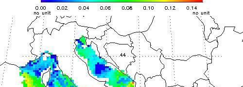
19 CloudSat INSTRUMENT CPR (Cloud Profiling Radar- developed by NASA/JPL and the Canadian Space Agency ) is a 94-GHz nadir-looking radar which measures the power backscattered by clouds as a function of distance from the radar. Physics of 94-GHz cloud sounding radars is extensively developed d and understood. d ( Rain radars ) 19


: Large regions")

20 CLOUDSAT DATA EXAMPLE CloudSat nighttime overpass of the thunderstorms over Kentucky, Tennessee, and Mississippi on Feb. 5, Image credits: NASA/JPL & NCAR The convection intensity is particularly evident in the CloudSat image (large hail present in these systems): Large regions of radar attenuation =>lack of surface signal return in the image) Evidence of multiple scattering => sub-surface return). 20
21 PARASOL Launched on 18/12/2004 Claude Monet 21
22 PARASOL Parasol is a microsatellite developed by CNES carrying the wide-field imaging radiometer/polarimeter POLDER (Polarization and Directionality of the Earth s Reflectances) POLDER is designed to improve our knowledge of the radiative and microphysical properties of clouds and aerosols by measuring the directionality and polarization of light reflected by the Earth-atmosphere atmosphere system. 22
23 PARASOL / INSTRUMENT The POLDER instrument observes the Earth surface under several angles at specific wavelengths including polarimetric components: (nm) Pol Y N N N Y N N N Y 23
24 PARASOL / MISSION (1) PARASOL mission => to characterize acte e the radiative properties of clouds and aerosols by exploiting its complementarities with the other A-Train instruments: CERES & MODIS on the AQUA satellite, the lidar on CALIPSO and the radar on CLOUDSAT, APS on GLORY. Complementarities => PARASOL ability to measure directional characteristics and polarization of emitted light. Ancillary result => measure of ground surfaces BDRF (Bidirectional Reflectance Function) 24
25 PARASOL / MISSION (2) PARASOL can provide: global AOD (Aerosol Optical Depth) over ocean and the fraction of AOD due to major natural a and anthropogenic components : fine mode, and a coarse mode with a combination of hydrated spherical and non spherical particles (dust). AOT (Aerosol Optical Thickness) of the fine mode over land 25
26 PARASOL SOME RESULTS 26


27 Aerosol products over Ocean: 27 August 2007 AOD 865 Effective Radius AOD fine


28 Aerosol products over Land: 27 August 2007 AOD Fine mode AOD Fine mode Lidar/CALIOP 28


29 How are aerosol particles transformed during transport? May 09, 2007 > 2.55µm May 10, µm May 11, µm May 12, µm Dust Event: May, 2007 Aerosol Effective Radius 29


30 GLORY Under integration Reunion Island Portal 30
31 GLORY MISSION Glory is designed to achieve two missions: To collect data on the chemical, microphysical, i and optical properties, and spatial and temporal distributions of aerosols. To continue collection of total solar irradiance data for the long-term climate record. 31
32 GLORY INSTRUMENTS APS (Aerosol Polarimetry Sensor) : scanning sensor collecting VIS, NIR & SWIR data scattered from aerosols and clouds => extremely accurate multi-angle observations of Earth & atmosphere spectral polarization & radiance. TIM (Total Irradiance Monitor) : radiometer that records total solar irradiance with extreme accuracy and precision i (including l redundancies, d self calibration, sun autonomous pointing). 32
33 CLOUDS & AEROSOLS: SYNERGIES Provide statistics on the vertical structure of clouds around the globe (Calipso & CloudSat) Provide statistics on the geographic and vertical distribution of aerosols around the globe (Calipso, Parasol & Glory) Provide estimates t of the percentage of Earth's clouds that t produce rain (CloudSat) Detect subvisible clouds in the upper troposphere and Polar Stratospheric t Clouds (Calipso) Provide vertically-resolved estimates of how much water and ice are in Earth's clouds (CloudSat) Detect snowfall from space (CloudSat) Estimate how efficiently the atmosphere produces rain from condensates (CloudSat) Provide an indirect estimate of how much clouds and aerosols contribute to atmospheric warming (Calipso, CloudSat, 33 Aqua/Modis, Parasol, Glory)
34 CLOUDS & AEROSOLS: EXAMPLES 34
35 CLOUDS & AEROSOLS: EXAMPLES 35
36 OCO Launch failed early NASA actively prepares OCO-2 CO2 Kolki in Western Siberian forest V.N.Sedykh
37 OCO- INSTRUMENT OCO single instrument : three parallel, high- resolution spectrometers, making simultaneous measurements of the carbon dioxide id and molecular oxygen absorption of sunlight reflected off the same location on Earth's surface ( : 0.76 µm; 1.61 µm; 2.06 µm) 37
38 OCO- Physical principles (1) OCO measures column averaged dry air CO2 mole fraction (Xco2). Models allow to infer the location of sources and sinks. OCO measures the intensity of reflected sunlight off of the Earth's surface at specific wavelengths where the absorption level is indicative of the abundance of molecules of interest (large number of densely spaced samples to compensate detrimental effects) 38
 is most sensitive to the CO2 concentration near the surface.")


39 OCO- Physical principles (2) The weak CO2 band ( ~1.61 µm) is most sensitive to the CO2 concentration near the surface. Measurements relatively clear and unambiguous. The strong CO2 band ( ~2.06 µm) provides a second and totally independent measure. Very sensitive to the presence of aerosols & variations in atmospheric pressure and humidity. Detecting and mitigating the presence of aerosols enhances the accuracy of Xco2 ( => synergy with other A-Train instruments). The O2 absorption band ( ~ 0.76 µm) provides the required reference spectra. 39


40 THE ORIGIN OF THE WORDING A-TRAIN A jazz song recorded by Duke Ellington and Ella Fizgerald in 1941: You must take the A-Tain To go to Sugar Hill Way up in Harlem.. If you miss the A-Train You ll find missed the quickest way To Harlem 40


41 THANK YOU FOR YOUR ATTENTION 41
History of Aerosol Remote Sensing. Mark Smithgall Maria Zatko 597K Spring 2009
 History of Aerosol Remote Sensing Mark Smithgall Maria Zatko 597K Spring 2009 Aerosol Sources Anthropogenic Biological decomposition from fertilizer and sewage treatment (ex. ammonium) Combustion of fossil
The Probabilistic Risk Assessment of the CloudSat Profiling Radar
 The Probabilistic Risk Assessment of the CloudSat Profiling Radar Todd Paulos, Alejo Engineering, Simi Valley, CA John Klohoker,,, Pasadena, CA May 2008 What is CloudSat? Launched on April 28, 2006 with
Interpretation of Polar-orbiting Satellite Observations. Atmospheric Instrumentation
 Interpretation of Polar-orbiting Satellite Observations Outline Polar-Orbiting Observations: Review of Polar-Orbiting Satellite Systems Overview of Currently Active Satellites / Sensors Overview of Sensor
3D data in climatology
 GIS Laboratory, Institute of Geography and Spatial Management, Jagiellonian University 1 3D applications There are at least three distinct fields of Earth sciences, were 3D data play an important (or fundamental)
Overview of The CALIPSO Mission
 Overview of The CALIPSO Mission Dave Winker NASA-LaRC LaRC,, PI Jacques Pelon IPSL/CNRS, co-pi Research Themes Improved understanding of the Earth s climate system is a primary goal of the Scientific Community
Radio Frequency Earth Science
 Radio Frequency Earth Science Overview for Committee On Radio Frequency (CORF) National Academy of Science National Research Council April 27, 2005 Bill.Watson@NASA.Gov Program Executive for Ground Networks
EPS-SG Candidate Observation Missions
 EPS-SG Candidate Observation Missions 3 rd Post-EPS User Consultation Workshop Peter Schlüssel Slide: 1 EPS-SG benefits to activities of NMSs Main Payload High-Resolution Infrared Sounding Microwave Sounding
REVISION OF THE STATEMENT OF GUIDANCE FOR GLOBAL NUMERICAL WEATHER PREDICTION. (Submitted by Dr. J. Eyre)
") WORLD METEOROLOGICAL ORGANIZATION Distr.: RESTRICTED CBS/OPAG-IOS (ODRRGOS-5)/Doc.5, Add.5 (11.VI.2002) COMMISSION FOR BASIC SYSTEMS OPEN PROGRAMME AREA GROUP ON INTEGRATED OBSERVING SYSTEMS ITEM: 4 EXPERT
WORLD METEOROLOGICAL ORGANIZATION Distr.: RESTRICTED CBS/OPAG-IOS (ODRRGOS-5)/Doc.5, Add.5 (11.VI.2002) COMMISSION FOR BASIC SYSTEMS OPEN PROGRAMME AREA GROUP ON INTEGRATED OBSERVING SYSTEMS ITEM: 4 EXPERT
Influence of Clouds and Aerosols on the Earth s Radiation Budget Using Clouds and the Earth s Radiant Energy System (CERES) Measurements
 Measurements") Influence of Clouds and Aerosols on the Earth s Radiation Budget Using Clouds and the Earth s Radiant Energy System (CERES) Measurements Norman G. Loeb Hampton University/NASA Langley Research Center Bruce
Influence of Clouds and Aerosols on the Earth s Radiation Budget Using Clouds and the Earth s Radiant Energy System (CERES) Measurements Norman G. Loeb Hampton University/NASA Langley Research Center Bruce
Lecture 19: Operational Remote Sensing in Visible, IR, and Microwave Channels
 MET 4994 Remote Sensing: Radar and Satellite Meteorology MET 5994 Remote Sensing in Meteorology Lecture 19: Operational Remote Sensing in Visible, IR, and Microwave Channels Before you use data from any
Satellite observation of atmospheric dust
 Satellite observation of atmospheric dust Taichu Y. Tanaka Meteorological Research Institute, Japan Meteorological Agency 11 April 2017, SDS WAS: Dust observation and modeling @WMO, Geneva Dust observations
Future NASA Atmospheric Missions: Adding to the A-Train Calipso OCO NPP CloudSat Glory
 Future NASA Atmospheric Missions: Adding to the A-Train James Gleason NASA Goddard Space Flight Center, Mail Code 613.3, Greenbelt, MD 20771, United States Abstract Following on the successful launch of
REMOTE SENSING TEST!!
 REMOTE SENSING TEST!! This is a really ugly cover page I m sorry. Name. Score / 100 Directions: (idk if I need to put this???) You have 50 minutes to take this test. You may use a cheatsheet (2 pages),
The EarthCARE mission: An active view on aerosols, clouds and radiation
 The EarthCARE mission: An active view on aerosols, clouds and radiation T. Wehr, P. Ingmann, T. Fehr Heraklion, Crete, Greece 08/06/2015 EarthCARE is ESA s sixths Earth Explorer Mission and will be implemented
REMOTE SENSING KEY!!
 REMOTE SENSING KEY!! This is a really ugly cover page I m sorry. Name Key. Score / 100 Directions: You have 50 minutes to take this test. You may use a cheatsheet (2 pages), a non-graphing calculator,
On the Satellite Determination of Multilayered Multiphase Cloud Properties. Science Systems and Applications, Inc., Hampton, Virginia 2
 JP1.10 On the Satellite Determination of Multilayered Multiphase Cloud Properties Fu-Lung Chang 1 *, Patrick Minnis 2, Sunny Sun-Mack 1, Louis Nguyen 1, Yan Chen 2 1 Science Systems and Applications, Inc.,
Atmospheric Lidar The Atmospheric Lidar (ATLID) is a high-spectral resolution lidar and will be the first of its type to be flown in space.
 is a high-spectral resolution lidar and will be the first of its type to be flown in space.") www.esa.int EarthCARE mission instruments ESA s EarthCARE satellite payload comprises four instruments: the Atmospheric Lidar, the Cloud Profiling Radar, the Multi-Spectral Imager and the Broad-Band Radiometer.
www.esa.int EarthCARE mission instruments ESA s EarthCARE satellite payload comprises four instruments: the Atmospheric Lidar, the Cloud Profiling Radar, the Multi-Spectral Imager and the Broad-Band Radiometer.
Monitoring CO 2 Sources and Sinks from Space with the Orbiting Carbon Observatory (OCO)
") NACP Remote Sensing Breakout Monitoring CO 2 Sources and Sinks from Space with the Orbiting Carbon Observatory (OCO) http://oco.jpl.nasa.gov David Crisp, OCO PI (JPL/Caltech) January 2007 1 of 14, Crisp,
NACP Remote Sensing Breakout Monitoring CO 2 Sources and Sinks from Space with the Orbiting Carbon Observatory (OCO) http://oco.jpl.nasa.gov David Crisp, OCO PI (JPL/Caltech) January 2007 1 of 14, Crisp,
NIR Solar Reference Spectrum Algorithm for the Orbiting Carbon Observatory (OCO)
") NIR Solar Reference Spectrum Algorithm for the Orbiting Carbon Observatory (OCO) Hartmut Bösch and Geoffrey Toon Jet Propulsion Laboratory, California Institute of Technology OCO Mission Global, space-based
NIR Solar Reference Spectrum Algorithm for the Orbiting Carbon Observatory (OCO) Hartmut Bösch and Geoffrey Toon Jet Propulsion Laboratory, California Institute of Technology OCO Mission Global, space-based
CALIPSO: Global aerosol and cloud observations from lidar and passive instruments
 CALIPSO: Global aerosol and cloud observations from lidar and passive instruments L. R. Poole* a, D. M. Winker** a, J. R. Pelon #b, M. P. McCormick ##c a NASA Langley Research Center; b Universite Pierre
A Time Lag Model to Estimate Rainfall Rate Based on GOES Data
 A Time Lag Model to Estimate Rainfall Rate Based on GOES Data Nazario D. Ramirez, Robert J. Kuligowski, and Joan M. Castro Octava Reunión Nacional de Percepción Remota y Sistemas Geográficos de Información
Instrumentation planned for MetOp-SG
 Instrumentation planned for MetOp-SG Bill Bell Satellite Radiance Assimilation Group Met Office Crown copyright Met Office Outline Background - the MetOp-SG programme The MetOp-SG instruments Summary Acknowledgements:
The Orbiting Carbon Observatory (OCO)
") GEMS 2006 Assembly The Orbiting Carbon Observatory (OCO) http://oco.jpl.nasa.gov David Crisp, OCO PI (JPL/Caltech) February 2006 1 of 13, OCO Dec 2005 Page 1 The Orbiting Carbon Observatory (OCO) OCO will
GEMS 2006 Assembly The Orbiting Carbon Observatory (OCO) http://oco.jpl.nasa.gov David Crisp, OCO PI (JPL/Caltech) February 2006 1 of 13, OCO Dec 2005 Page 1 The Orbiting Carbon Observatory (OCO) OCO will
Lecture 4b: Meteorological Satellites and Instruments. Acknowledgement: Dr. S. Kidder at Colorado State Univ.
 Lecture 4b: Meteorological Satellites and Instruments Acknowledgement: Dr. S. Kidder at Colorado State Univ. US Geostationary satellites - GOES (Geostationary Operational Environmental Satellites) US
Atmospheric Measurements from Space
 Atmospheric Measurements from Space MPI Mainz Germany Thomas Wagner Satellite Group MPI Mainz Part 1: Basics Break Part 2: Applications Part 1: Basics of satellite remote sensing Why atmospheric satellite
Meteorological Satellite Image Interpretations, Part III. Acknowledgement: Dr. S. Kidder at Colorado State Univ.
 Meteorological Satellite Image Interpretations, Part III Acknowledgement: Dr. S. Kidder at Colorado State Univ. Dates EAS417 Topics Jan 30 Introduction & Matlab tutorial Feb 1 Satellite orbits & navigation
What are Aerosols? Suspension of very small solid particles or liquid droplets Radii typically in the range of 10nm to
 What are Aerosols? Suspension of very small solid particles or liquid droplets Radii typically in the range of 10nm to 10µm Concentrations decrease exponentially with height N(z) = N(0)exp(-z/H) Long-lived
National Aeronautics and Space Administration. Earth Day is everyday at NASA. activity booklet
 National Aeronautics and Space Administration Earth Day is everyday at NASA activity booklet Earth Day is everyday at NASA NASA s Fleet of Earth Observing Satellites ACRIMSAT Landsat 7 Aqua SORCE Terra
PHEOS - Weather, Climate, Air Quality
 Aerosol & cloud remote sensing over the Arctic : perspectives for the PHEMOS and meteorological imager payloads on the PCW mission Norm O Neill, Auromeet Saha, U. de Sherbrooke Chris E. Sioris, Jack McConnell,
Global observations from CALIPSO
 Global observations from CALIPSO Dave Winker, Chip Trepte, and the CALIPSO team NRL, Monterey, 27-29 April 2010 Mission Overview Features: Two-wavelength backscatter lidar First spaceborne polarization
Projects in the Remote Sensing of Aerosols with focus on Air Quality
 Projects in the Remote Sensing of Aerosols with focus on Air Quality Faculty Leads Barry Gross (Satellite Remote Sensing), Fred Moshary (Lidar) Direct Supervision Post-Doc Yonghua Wu (Lidar) PhD Student
Recent Update on MODIS C6 and VIIRS Deep Blue Aerosol Products
 Recent Update on MODIS C6 and VIIRS Deep Blue Aerosol Products N. Christina Hsu, Photo taken from Space Shuttle: Fierce dust front over Libya Corey Bettenhausen, Andrew M. Sayer, and Rick Hansell Laboratory
F O U N D A T I O N A L C O U R S E
 F O U N D A T I O N A L C O U R S E December 6, 2018 Satellite Foundational Course for JPSS (SatFC-J) F O U N D A T I O N A L C O U R S E Introduction to Microwave Remote Sensing (with a focus on passive
GCOM-W1 now on the A-Train
 GCOM-W1 now on the A-Train GCOM-W1 Global Change Observation Mission-Water Taikan Oki, K. Imaoka, and M. Kachi JAXA/EORC (& IIS/The University of Tokyo) Mini-Workshop on A-Train Science, March 8 th, 2013
Remote sensing of ice clouds
 Remote sensing of ice clouds Carlos Jimenez LERMA, Observatoire de Paris, France GDR microondes, Paris, 09/09/2008 Outline : ice clouds and the climate system : VIS-NIR, IR, mm/sub-mm, active 3. Observing
Emission Limb sounders (MIPAS)
") Emission Limb sounders (MIPAS) Bruno Carli ENVISAT ATMOSPHERIC PACKAGE MIPAS Michelson Interferometric Passive Atmospheric Sounder GOMOS Global Ozone Monitoring by Occultation of Stars SCIAMACHY Scanning
Emission Limb sounders (MIPAS) Bruno Carli ENVISAT ATMOSPHERIC PACKAGE MIPAS Michelson Interferometric Passive Atmospheric Sounder GOMOS Global Ozone Monitoring by Occultation of Stars SCIAMACHY Scanning
EUMETSAT STATUS AND PLANS
 1 EUM/TSS/VWG/15/826793 07/10/2015 EUMETSAT STATUS AND PLANS François Montagner, Marine Applications Manager, EUMETSAT WMO Polar Space Task Group 5 5-7 October 2015, DLR, Oberpfaffenhofen PSTG Strategic
Chapter 4 Nadir looking UV measurement. Part-I: Theory and algorithm
 Chapter 4 Nadir looking UV measurement. Part-I: Theory and algorithm -Aerosol and tropospheric ozone retrieval method using continuous UV spectra- Atmospheric composition measurements from satellites are
1. The frequency of an electromagnetic wave is proportional to its wavelength. a. directly *b. inversely
 CHAPTER 3 SOLAR AND TERRESTRIAL RADIATION MULTIPLE CHOICE QUESTIONS 1. The frequency of an electromagnetic wave is proportional to its wavelength. a. directly *b. inversely 2. is the distance between successive
Satellite Constraints on Arctic-region Airborne Particles Ralph Kahn NASA Goddard Space Flight Center
 Satellite Constraints on Arctic-region Airborne Particles Ralph Kahn NASA Goddard Space Flight Center Sea of Okhotsk, MODIS image Feb. 6, 2007, NASA Earth Observatory Arctic Aerosol Remote Sensing Overview
CHAPTER 8. AEROSOLS 8.1 SOURCES AND SINKS OF AEROSOLS
 1 CHAPTER 8 AEROSOLS Aerosols in the atmosphere have several important environmental effects They are a respiratory health hazard at the high concentrations found in urban environments They scatter and
APPENDIX 2 OVERVIEW OF THE GLOBAL PRECIPITATION MEASUREMENT (GPM) AND THE TROPICAL RAINFALL MEASURING MISSION (TRMM) 2-1
 AND THE TROPICAL RAINFALL MEASURING MISSION (TRMM) 2-1") APPENDIX 2 OVERVIEW OF THE GLOBAL PRECIPITATION MEASUREMENT (GPM) AND THE TROPICAL RAINFALL MEASURING MISSION (TRMM) 2-1 1. Introduction Precipitation is one of most important environmental parameters.
APPENDIX 2 OVERVIEW OF THE GLOBAL PRECIPITATION MEASUREMENT (GPM) AND THE TROPICAL RAINFALL MEASURING MISSION (TRMM) 2-1 1. Introduction Precipitation is one of most important environmental parameters.
Course outline, objectives, workload, projects, expectations
 Course outline, objectives, workload, projects, expectations Introductions Remote Sensing Overview Elements of a remote sensing observing system 1. platform (satellite, surface, etc) 2. experimental design
PRINCIPLES OF REMOTE SENSING. Electromagnetic Energy and Spectral Signatures
 PRINCIPLES OF REMOTE SENSING Electromagnetic Energy and Spectral Signatures Remote sensing is the science and art of acquiring and analyzing information about objects or phenomena from a distance. As humans,
Satellite remote sensing of aerosols & clouds: An introduction
 Satellite remote sensing of aerosols & clouds: An introduction Jun Wang & Kelly Chance April 27, 2006 junwang@fas.harvard.edu Outline Principals in retrieval of aerosols Principals in retrieval of water
Observability Meeting NRL Monterey, CA April 2010
 Hal Maring, Program Scientist Michael Mishchenko, Project Scientist Brian Cairns, APS Scientist Greg Kopp, TIM Scientist Bryan Fafaul, Project Manager Observability Meeting NRL Monterey, CA 27-29 April
Land Surface Temperature Measurements From the Split Window Channels of the NOAA 7 Advanced Very High Resolution Radiometer John C.
 Land Surface Temperature Measurements From the Split Window Channels of the NOAA 7 Advanced Very High Resolution Radiometer John C. Price Published in the Journal of Geophysical Research, 1984 Presented
NEW CANDIDATE EARTH EXPLORER CORE MISSIONS THEIR IMPORTANCE FOR ATMOSPHERIC SCIENCE AND APPLICATION
 NEW CANDIDATE EARTH EXPLORER CORE MISSIONS THEIR IMPORTANCE FOR ATMOSPHERIC SCIENCE AND APPLICATION P. Ingmann and J. Langen European Space Research and Technology Centre (ESTEC) P.O. Box 299, NL-2200
Global Cloud Climatologies from satellite-based InfraRed Sounders (TOVS, AIRS, IASI) +
 +") Global Cloud Climatologies from satellite-based InfraRed Sounders (TOVS, AIRS, IASI) + AIRS-CALIPSO-CloudSat Synergy Claudia Stubenrauch * until 2010 S. Cros*, A. Guignard, N. Lamquin*, R. Armante, A.
Global Cloud Climatologies from satellite-based InfraRed Sounders (TOVS, AIRS, IASI) + AIRS-CALIPSO-CloudSat Synergy Claudia Stubenrauch * until 2010 S. Cros*, A. Guignard, N. Lamquin*, R. Armante, A.
Remote Sensing in Meteorology: Satellites and Radar. AT 351 Lab 10 April 2, Remote Sensing
 Remote Sensing in Meteorology: Satellites and Radar AT 351 Lab 10 April 2, 2008 Remote Sensing Remote sensing is gathering information about something without being in physical contact with it typically
NOAA Report. Hal Bloom Mitch Goldberg NOAA/NESDIS
 NOAA Report Hal Bloom Mitch Goldberg NOAA/NESDIS Summary of Major Events at NESDIS (of interest to ITSC) NOAA/NASA addressing NPOESS Climate Sensors Letter of agreement signed with JAXA on GCOM interagency
McIDAS support of Suomi-NPP /JPSS and GOES-R L2
 McIDAS support of Suomi-NPP /JPSS and GOES-R L2 William Straka III 1 Tommy Jasmin 1, Bob Carp 1 1 Cooperative Institute for Meteorological Satellite Studies, Space Science and Engineering Center, University
Princeton Science Olympiad Invitational Remote Sensing Exam
 Princeton Science Olympiad Invitational Remote Sensing Exam Team Name: Team Number: Raw Score: Tiebreaker: 1 / 2 / 3 Place: Directions: You have 50 minutes to complete this exam. You may have with you
Monitoring Air Pollution from Space
 Monitoring Air Pollution from Space Media Regional Training Workshop 16 th Nov 20 th Nov 2015 Shreta Ghimire International Centre for Integrated Mountain Development Kathmandu, Nepal Why do we study air
Final Review Meteorology
 Final Review Meteorology Multiple Choice Identify the choice that best completes the statement or answers the question. 1. Which of the following is an example of climate? a. A sudden snowstorm resulted
A new perspective on aerosol direct radiative effects in South Atlantic and Southern Africa
 A new perspective on aerosol direct radiative effects in South Atlantic and Southern Africa Ian Chang and Sundar A. Christopher Department of Atmospheric Science University of Alabama in Huntsville, U.S.A.
Arctic Clouds and Radiation Part 2
 Arctic Clouds and Radiation Part 2 Glen Lesins Department of Physics and Atmospheric Science Dalhousie University Create Summer School, Alliston, July 2013 No sun Arctic Winter Energy Balance 160 W m -2
Remote Sensing How we know what we know A Brief Tour
 Remote Sensing How we know what we know A Brief Tour Dr. Erik Richard Dr. Jerald Harder LASP Richard 1 Remote Sensing The measurement of physical variables (usually light or sound) from outside of a medium
IARA - GoAmazon 2014
 IARA - GoAmazon 2014 Activities related to Aerosol, Cloud, Precipitation, and Radiation Interactions and Dynamics of Convective Cloud Systems (ACRIDICON) and CHUVA Project Luiz.Machado@cptec.inpe.br CHUVA
The EarthCARE mission: An active view on aerosols, clouds and radiation
 The EarthCARE mission: An active view on aerosols, clouds and radiation T. Wehr, T. Fehr, P. Ingmann, J. v. Bismarck ESRIN, Frascati, Italy 20/10/2015 EARTH Clouds, Aerosols and Radiation Explorer EarthCARE
Ground-based Validation of spaceborne lidar measurements
 Ground-based Validation of spaceborne lidar measurements Ground-based Validation of spaceborne lidar measurements to make something officially acceptable or approved, to prove that something is correct
Measuring Carbon Dioxide from the A-Train: The OCO-2 Mission
 Measuring Carbon Dioxide from the A-Train: The OCO-2 Mission David Crisp, OCO-2 Science Team Leader for the OCO-2 Science Team Jet Propulsion Laboratory, California Institute of Technology March 2013 Copyright
An Observational Study of the Relationship between Cloud, Aerosol and Meteorology in Marine Stratus Regions
 An Observational Study of the Relationship between Cloud, Aerosol and Meteorology in Marine Stratus Regions Norman G. Loeb NASA Langley Research Center Hampton, VA Oct 18 th, 2006, AeroCom Meeting (Virginia
P6.13 GLOBAL AND MONTHLY DIURNAL PRECIPITATION STATISTICS BASED ON PASSIVE MICROWAVE OBSERVATIONS FROM AMSU
 P6.13 GLOBAL AND MONTHLY DIURNAL PRECIPITATION STATISTICS BASED ON PASSIVE MICROWAVE OBSERVATIONS FROM AMSU Frederick W. Chen*, David H. Staelin, and Chinnawat Surussavadee Massachusetts Institute of Technology,
The Atmosphere. Topic 3: Global Cycles and Physical Systems. Topic 3: Global Cycles and Physical Systems. Topic 3: Global Cycles and Physical Systems
 The Atmosphere 1 How big is the atmosphere? Why is it cold in Geneva? Why do mountaineers need oxygen on Everest? 2 A relatively thin layer of gas over the Earths surface Earth s radius ~ 6400km Atmospheric
Spectrum of Radiation. Importance of Radiation Transfer. Radiation Intensity and Wavelength. Lecture 3: Atmospheric Radiative Transfer and Climate
 Lecture 3: Atmospheric Radiative Transfer and Climate Radiation Intensity and Wavelength frequency Planck s constant Solar and infrared radiation selective absorption and emission Selective absorption
The current status of FY-3D
 The current status of FY-3D Xiang Fang National Satellite Meteorological Center, China Meteorological Administration (NSMC/CMA) OUTLINE Overview Key instruments onboard FY-3D Products and data service
Period 13 Solutions: Earth as an Energy System
 Period 13 Solutions: Earth as an Energy System 13.1 The Earth-Sun System 1) Energy from the sun Observe the models of the Earth, Moon, and Sun in the room. a) Imagine that the distance between the Earth
Lecture 3: Atmospheric Radiative Transfer and Climate
 Lecture 3: Atmospheric Radiative Transfer and Climate Solar and infrared radiation selective absorption and emission Selective absorption and emission Cloud and radiation Radiative-convective equilibrium
1. CLIMATOLOGY: 2. ATMOSPHERIC CHEMISTRY:
 What is meteorology? A. METEOROLOGY: an atmospheric science that studies the day to day changes in the atmosphere 1. ATMOSPHERE: the blanket of gas that surrounds the surface of Earth; the air 2. WEATHER:
The Atmosphere. All of it. In one hour. Mikael Witte 10/27/2010
 The Atmosphere All of it. In one hour. Mikael Witte 10/27/2010 Outline Structure Dynamics - heat transport Composition Trace constituent compounds Some Atmospheric Processes Ozone destruction in stratosphere
Unit 3 Review Guide: Atmosphere
 Unit 3 Review Guide: Atmosphere Atmosphere: A thin layer of gases that forms a protective covering around the Earth. Photosynthesis: Process where plants take in carbon dioxide and release oxygen. Trace
GRACE Cloudsat CALIPSO Aqua. Metop TRMM TOPEX. Meteor/ SAGE GIFTS NOAA/ POES. Landsat GOES MTSAT. SeaWiFS. Aura. Terra MSG. Jason ICESat SORCE
 TRMM Metop GRACE Cloudsat CALIPSO Aqua TOPEX Meteor/ SAGE GIFTS NOAA/ POES Landsat GOES SeaWiFS MTSAT Terra Aura Jason ICESat SORCE MSG THE EARTH SYSTEM SCIENCE It is the science that studies the whole
I T A T I O N H B I T B T V A O C J K M R S A T M O S P H E R E
 Word Search Directions: Below are definitions of vocabulary terms. Figure out each term and then find and circle it in the puzzle. Words may appear horizontally, vertically, or diagonally. K E M I S S
Joint Polar Satellite System. 3 rd Post-EPS User Consultation Workshop Mike Haas
 3 rd Post-EPS User Consultation Workshop Mike Haas Overview Introduction - Policy Drivers - Management System Description - Space Segment - Ground Segment Partnerships Status Benefits 2 Introduction (Policy
TEMPO Aerosols. Need for TEMPO-ABI Synergy
 TEMPO Aerosols Need for TEMPO-ABI Synergy Omar Torres, Hiren Jethva, Changwoo Ahn CEOS - 2018 NOAA-College Park May 04, 2018 Use of near UV Satellite Observations for retrieving aerosol properties over
AIRS Level 1b. Tom Pagano AIRS Project Project Manager. Hartmut Aumann AIRS Project Scientist
 AIRS Level 1b Tom Pagano AIRS Project Project Manager Hartmut Aumann AIRS Project Scientist Jet Propulsion Laboratory California Institute of Technology and Ken Overoye AIRS Calibration System Engineer
The Atmosphere and Atmospheric Energy Chapter 3 and 4
 The Atmosphere and Atmospheric Energy Chapter 3 and 4 Size of the Earth s Atmosphere Atmosphere produced over 4.6 billion years of development Protects us from radiation Completely surrounds the earth
New NASA Ocean Observations and Coastal Applications
 New NASA Ocean Observations and Coastal Applications Duane Armstrong Chief, Applied Science & Technology Project Office August 20, 2014 1 Outline NASA s new Earth Science Ocean Science Missions for 2014
Climate Dynamics (PCC 587): Feedbacks & Clouds
: Feedbacks & Clouds") Climate Dynamics (PCC 587): Feedbacks & Clouds DARGAN M. W. FRIERSON UNIVERSITY OF WASHINGTON, DEPARTMENT OF ATMOSPHERIC SCIENCES DAY 6: 10-14-13 Feedbacks Climate forcings change global temperatures directly
Climate Dynamics (PCC 587): Feedbacks & Clouds DARGAN M. W. FRIERSON UNIVERSITY OF WASHINGTON, DEPARTMENT OF ATMOSPHERIC SCIENCES DAY 6: 10-14-13 Feedbacks Climate forcings change global temperatures directly
Remote Sensing C. Rank: Points: Science Olympiad North Regional Tournament at the University of Florida. Name(s): Team Name: School Name:
: Team Name: School Name:") Remote Sensing C Science Olympiad North Regional Tournament at the University of Florida Rank: Points: Name(s): Team Name: School Name: Team Number: Instructions: DO NOT BEGIN UNTIL GIVEN PERMISSION. DO
Remote Sensing C Science Olympiad North Regional Tournament at the University of Florida Rank: Points: Name(s): Team Name: School Name: Team Number: Instructions: DO NOT BEGIN UNTIL GIVEN PERMISSION. DO
WATER IN THE ATMOSPHERE
 WATER IN THE ATMOSPHERE During a rainstorm, the air feels moist On a clear, cloudless day, the air may feel dry As the sun heats the land and oceans, the amount of water in the atmosphere changes Water
Inaugural University of Michigan Science Olympiad Tournament
 Inaugural University of Michigan Science Olympiad Tournament The test may be taken apart. Ties will be broken based on predetermined questions and quality of response. Remote Sensing Test length: 50 Minutes
ABB Remote Sensing Atmospheric Emitted Radiance Interferometer AERI system overview. Applications
 The ABB Atmospheric Emitted Radiance Interferometer AERI provides thermodynamic profiling, trace gas detection, atmospheric cloud aerosol study, air quality monitoring, and more. AERI high level overview
Thermal And Near infrared Sensor for carbon Observation (TANSO) On board the Greenhouse gases Observing SATellite (GOSAT) Research Announcement
 On board the Greenhouse gases Observing SATellite (GOSAT) Research Announcement") Thermal And Near infrared Sensor for carbon Observation (TANSO) On board the Greenhouse gases Observing SATellite (GOSAT) Research Announcement Appendix A Outlines of GOSAT and TANSO Sensor GOSAT (Greenhouse
Thermal And Near infrared Sensor for carbon Observation (TANSO) On board the Greenhouse gases Observing SATellite (GOSAT) Research Announcement Appendix A Outlines of GOSAT and TANSO Sensor GOSAT (Greenhouse
Changes in Earth s Albedo Measured by satellite
 Changes in Earth s Albedo Measured by satellite Bruce A. Wielicki, Takmeng Wong, Norman Loeb, Patrick Minnis, Kory Priestley, Robert Kandel Presented by Yunsoo Choi Earth s albedo Earth s albedo The climate
MEASURING TRACE GAS PROFILES FROM SPACE
 MEASURING TRACE GAS PROFILES FROM SPACE Caroline Nowlan Atomic and Molecular Physics Division Harvard-Smithsonian Center for Astrophysics Collaborators: Kelly Chance, Xiong Liu, Gonzalo Gonzalez Abad,
An Overview of the Radiation Budget in the Lower Atmosphere
 An Overview of the Radiation Budget in the Lower Atmosphere atmospheric extinction irradiance at surface P. Pilewskie 300 University of Colorado Laboratory for Atmospheric and Space Physics Department
This presentation was assembled as part of the outreach initiative for the Canadian Network for the Detection of Atmospheric Change.
 This will be a lesson for students in grades 9-12. The subject matter is climate change - the greenhouse effect, greenhouse gases, how greenhouse gases are measured and studied, and the impacts of climate
anemometer a weather instrument that measures wind speed with wind-catching cups (SRB, IG)
") FOSS Weather on Earth Module Glossary 3 rd Edition 2012 absorb to soak in air the mixture of gases surrounding Earth air pressure the force exerted on a surface by the mass of the air above it anemometer
FOSS Weather on Earth Module Glossary 3 rd Edition 2012 absorb to soak in air the mixture of gases surrounding Earth air pressure the force exerted on a surface by the mass of the air above it anemometer
Earth Science Flight Mission Overview
 Earth Science Flight Mission Overview Nand Topiwala Science Mission Directorate NASA Headquarters April 25, 2007 Earth Science Missions Afternoon Constellation, or A-Train, Multi-Satellite Observatory
CMA Consideration on early-morning orbit satellite
 CMA Consideration on early-morning orbit satellite National Satellite Meteorological Center,CMA Yang Jun CGMS 40 in Lugano, 5-9 Nov., 2012 Outline Background Gap analysis on the sounding data coverage
Weather & Climate. Sanjay S. Limaye Space Science & Engineering Center University of Wisconsin-Madison
 Weather & Climate Sanjay S. Limaye Space Science & Engineering Center University of Wisconsin-Madison 1 What is Weather? Webster s New Collegiate Dictionary: state of the atmosphere with respect to heat
Lecture 4: Meteorological Satellites and Instruments. Acknowledgement: Dr. S. Kidder at Colorado State Univ.
 Lecture 4: Meteorological Satellites and Instruments Acknowledgement: Dr. S. Kidder at Colorado State Univ. Homework for the Spring Break: get some tangible, preliminary results for your final project.
Monitoring Climate Change from Space
 Monitoring Climate Change from Space Richard Allan (email: r.p.allan@reading.ac.uk twitter: @rpallanuk) Department of Meteorology, University of Reading Why Monitor Earth s Climate from Space? Global Spectrum
Clouds, Precipitation and their Remote Sensing
 Clouds, Precipitation and their Remote Sensing Prof. Susanne Crewell AG Integrated Remote Sensing Institute for Geophysics and Meteorology University of Cologne Susanne Crewell, Kompaktkurs, Jülich 24.
Lectures 7 and 8: 14, 16 Oct Sea Surface Temperature
 Lectures 7 and 8: 14, 16 Oct 2008 Sea Surface Temperature References: Martin, S., 2004, An Introduction to Ocean Remote Sensing, Cambridge University Press, 454 pp. Chapter 7. Robinson, I. S., 2004, Measuring
Clouds, Haze, and Climate Change
 Clouds, Haze, and Climate Change Jim Coakley College of Oceanic and Atmospheric Sciences Earth s Energy Budget and Global Temperature Incident Sunlight 340 Wm -2 Reflected Sunlight 100 Wm -2 Emitted Terrestrial
Measurements of Ozone. Why is Ozone Important?
 Anthropogenic Climate Changes CO 2 CFC CH 4 Human production of freons (CFCs) Ozone Hole Depletion Human production of CO2 and CH4 Global Warming Human change of land use Deforestation (from Earth s Climate:
Summary Remote Sensing Seminar
 Summary Remote Sensing Seminar Lectures at CREST Paul Menzel NOAA/NESDIS/ORA March 2006 Satellite remote sensing of the Earth-atmosphere Observations depend on telescope characteristics (resolving power,