Impact of NASA EOS data on the scientific literature: 16 years of published research results from Terra, Aqua, Aura, and Aquarius
|
|
|
- Amy Lyons
- 6 years ago
- Views:
Transcription

1 Impact of NASA EOS data on the scientific literature: 16 years of published research results from Terra, Aqua, Aura, and Aquarius Gene R. Major NASA Goddard Library Nebulous Connections April 4, 2017


2 RESACs/RA Cs TDRSS & Ground Tracking Stations Data Processing & Mission Control DAACs & Instrument Teams & SIPS Research Users ESIP Educators Public Value Added Providers Acquire data Flight Ops, data capture Interagency Partners Int l Partners Science data processing, archive, data mgmt & distribution (via media/internet)

3 Data Publications Citations

4 Citation of EOS Data Sets Instrument keywords in the literature as indicators of EOS data set usage and a proxy for data citation
5 Results From Web of Science Web of Science journal citations Did not use conference proceedings or books 19,211 papers published in the 16-year period using EOS instrument data Over 920 different journals 61% of the papers used MODIS data
6 Journal Articles Citing EOS Data by Instrument
7 Journal Articles Using EOS Data Aquarius 6/11/11 Terra 12/18/99 Aura 7/15/04 Aqua 5/4/02
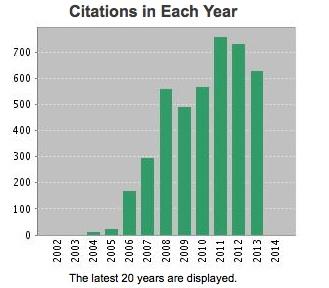
8 Total Citations Per Year


9 WoS Data Extraction Method 1. Search Web of Science for each instrument Construct keyword searches. Some instrument names are unique; others (ASTER) required additional qualifiers 2. Download WoS records 3. Import records into spreadsheets
 Journal of Geophysical Research Atmospheres (1,394 articles, JIF=3.318) International Journal of Remote Sensing (1,133 articles, JIF=1.640) Remote Sensing (814 articles; JIF=3.")
10 EOS Landscape in the Scientific Literature Approximately 52% of all articles were published in 15 journals. Top 5: Remote Sensing of Environment (1,538 articles, JIF=5.881) Journal of Geophysical Research Atmospheres (1,394 articles, JIF=3.318) International Journal of Remote Sensing (1,133 articles, JIF=1.640) Remote Sensing (814 articles; JIF=3.036) Atmospheric Chemistry and Physics (805 articles, JIF=4.456) All of these journals have Journal Impact Factors (JIF) above the median JIF for journals in these subject areas: Meteorology and Atmospheric Science, Oceanography, and Remote Sensing
11 Top 10 Journals Publishing Papers using EOS Data
12 Top 10 highly cited EOS Publications ( ) Title Journal Publication Year Overview of the radiometric and biophysical performance of the MODIS vegetation indices The MODIS aerosol algorithm, products, and validation Global land cover classification at 1km spatial resolution using a classification tree approach Global land cover mapping from MODIS: algorithms and early results First operational BRDF, albedo nadir reflectance products from MODIS An extended AVHRR 8-km NDVI dataset compatible with MODIS and SPOT vegetation NDVI data The MODIS cloud products: Algorithms and examples from Terra Global fire emissions and the contribution of deforestation, savanna, forest, agricultural, and peat fires ( ) Times Cited Remote Sensing of Environment ,161 J. of the Atmospheric Sciences International J. of Remote Sensing Remote Sensing of Environment Remote Sensing of Environment International J. of Remote Sensing IEEE Trans. On Geoscience and Remote Sensing Atmospheric Chemistry and Physics Global products of vegetation leaf area Remote Sensing of and fraction absorbed PAR from year one Environment of MODIS data Interannual variability in global biomass burning emissions from 1997 to 2004 Atmospheric Chemistry and Physics , , , ,


13 Diversity of Applications of EOS Data EOS data was also reported in journals outside the mainstream, indicative of the wide applications of EOS data: Harmful Algae Archaeologic Prospection Quarternary Science Reviews Infection Genetics and Evolution Journal of Vector Ecology Australian Journal of Grape and Wine Research

14 International Use of EOS Data EOS-related articles also published in international journals: Chinese Science Bulletin Arabian Journal of Geosciences Rivista Italiana Di Telerilevamento Russian Meteorology and Hydrology Journal of the Korean Meteorological Society Izvestiya Atmospheric and Oceanic Physics

15 Impact of EOS Papers on the Literature Over 33% of the papers from Remote Sensing of the Environment for use EOS data Journal Remote Sensing of Environment Total Papers EOS Papers % Total 4,640 1, JGR- Atmospheres Int. Journal of Remote Sens. 14,587 1, ,536 1, Remote Sensing 3, Atmospheric Chemistry & Physics 7,
16 Impact of EOS Data (from WoS) Instrument Times Cited h-index Highest cited Avg. Citations/Yr MODIS ASTER AMSR-E MISR OMI AMSU AIRS CERES MLS MOPITT TES HSB HIRDLS Aquarius/SAC-D High h-index (162 MODIS [Terra, Aqua] papers have 162 citations or more). The most highly cited paper from AMSU [Aqua] had an average of citations/year over the 14 year period ( ).

17 Terra Output Most Common Keywords 14,471 Total Peer-Reviewed Publications Avg. Citations/Pub 869 Unique Journals 26,572 Unique Authors 6,480 Unique Institutions 285,023 Total Citations 167 Countries Top 10 Impact Factor Journals by Pub Count Top 10 Institutions by # Publications NASA 1899 Chinese Academy of Sciences 1522 University of Maryland 784 Beijing Normal University 544 California Institute of Technology 420 NOAA 414 University of Wisconsin 318 University Chinese Academy of Sciences 284 Boston University 242 University of Maryland - Baltimore County 240 Top 10 Countries by # Publications USA 6469 Peoples Republic of China 3118 France 932 Germany 914 England 792 Canada 699 Italy 681 Japan 599 Netherlands 490 Australia 464
18 Aqua Output ,385 Total Peer-Reviewed Publications Avg. Citations/Pub 802 Unique Journals 25,529 Unique Authors 6,184 Unique Institutions 275,136 Total Citations 143 Countries Most Common Keywords Top 10 Impact Factor Journals by Pub Count Top 10 Institutions by # Publications NASA 1941 Chinese Academy of Sciences 1532 University of Maryland 829 Beijing Normal University 536 NOAA 524 California Institute of Technology 445 University of Wisconsin 377 University Chinese Academy of Sciences 291 University of Maryland - Baltimore County 273 Boston University 221 Top 10 Countries by # Publications USA 6563 Peoples Republic of China 3131 France 944 Germany 879 England 804 Italy 677 Canada 670 Japan 586 Australia 477 Netherlands 460

19 Aura Output ,637 Total Peer-Reviewed Publications Avg. Citations/Pub 149 Unique Journals 4,251 Unique Authors 1,151 Unique Institutions 31,211 Total Citations 71 Countries Most Common Keywords Top 10 Impact Factor Journals by Pub Count Top 10 Institutions by # Publications NASA 437 California Institute of Technology 365 University of Colorado 131 NCAR 129 Royal Netherlands Meteorological Institute 97 Harvard Smithsonian Center for Astrophysics 88 UMBC 80 University of Toronto 73 Harvard University 73 Finnish Meteorological Institute 54 Top 10 Countries by # Publications USA 930 Germany 220 Canada 175 Netherlands 173 England 168 France 138 Peoples Republic of China 128 Belgium 70 Finland 63 Scotland 60
20 Aquarius Output Most Common Keywords 169 Total Peer-Reviewed Publications 6.76 Avg. Citations/Pub 35 Unique Journals 469 Unique Authors 186 Unique Institutions 1,143 Total Citations 25 Countries Top 10 Impact Factor Journals by Pub Count Top 10 Institutions by # Publications California Institute of Technology 41 NASA 26 Earth & Space Research 17 Chapman University 11 IFREMER 10 University of Maryland 10 Chinese Adademy of Sciences 9 University of South Carolina 9 Remote Sensing Systems 5 USRA 6 Top 10 Countries by # Publications USA 125 France 20 People's Republic of China 13 India 11 Argentina 10 Spain 10 Italy 6 England 6 Germany 4 South Korea 4
21 Bibliometric Network of Journals oceans Bibliographic Coupling of journals land, remote sensing atmospheric science hydrology, agriculture geophysics Snow and ice
")
22 Bibliometric Network of Journals (item density)
23 Top 10 Most Cited Journals
24 Co-Author Bibliometric Network
25 Bibliographic Coupling of Authors
26 Co-Citation of Authors
27 Bibliometric Network of Countries Bibliographic Coupling Of countries

28 Bibliometric Network of Organizations Bibliographic Coupling of organizations

29 Bibliometric Co-Occurrence of Terms


30 Goddard Authors The Goddard Library has established a repository of all publications authored or co-authored by a NASA/Goddard researcher. Going back to 2003, we have over 2,960 author records from over 18,624 journal articles, proceedings, book chapters, and books.

31 Goddard Institutional Repository Earth Sciences Earth Sciences Division (Code 610): includes Atmospheric Chemistry & Dynamics, Climate & Radiation, Mesoscale Atmospheric Processes, Global Modelling & Assimilation, and climate research from the Goddard Institute for Space Studies
32 # of Peer-Reviewed EOS Papers in the IR


33 Wrapping Up Although specific data sets are not usually cited, EOS data cited in the literature ultimately came from the NASA DAACs or affiliated data centers. Papers using data sets can be a proxy for data set citation. Journals that published papers using EOS data are diverse: MODIS especially, is cited in non-traditional Earth science journals. Many papers are from international journals. EOS papers tend to be published in journals with high Journal Impact Factors and are highly cited. Bibliometric tools, such as VOSViewer can provide further illumination on bibliometric relationships


34 Questions? Gene R. Major NASA Goddard Library
NASA Earth Science Data Systems Program. Martha Maiden Program Executive, Earth Science Data Systems Earth Science Subcommittee November 28, 2012
 NASA Earth Science Data Systems Program Martha Maiden Program Executive, Earth Science Data Systems Earth Science Subcommittee November 28, 2012 NASA s Earth Observing System Data and Information System
Once a specific data set is selected, NEO will list related data sets in the panel titled Matching Datasets, which is to the right of the image.
 NASA Earth Observations (NEO): A Brief Introduction NEO is a data visualization tool that allows users to explore a wealth of environmental data collected by NASA satellites. The satellites use an array
ESIP Summer 2012 Meeting Innovation Applied through Geospatial Application
 ESIP Summer 2012 Meeting Innovation Applied through Geospatial Application Ryan Boller, George Chang Kevin Murphy, Charles Thompson, Lucian Plesea, Jeff Schmaltz, Tilak Joshi, Shriram Ilavajhala, Diane
Greening of Arctic: Knowledge and Uncertainties
 Greening of Arctic: Knowledge and Uncertainties Jiong Jia, Hesong Wang Chinese Academy of Science jiong@tea.ac.cn Howie Epstein Skip Walker Moscow, January 28, 2008 Global Warming and Its Impact IMPACTS
Moderate Resolution Imaging Spectroradiometer (MODIS) Products and Potential Applications For Environmental and Climatic Monitoring in China
 Products and Potential Applications For Environmental and Climatic Monitoring in China") Moderate Resolution Imaging Spectroradiometer (MODIS) Products and Potential Applications For Environmental and Climatic Monitoring in China Jianhe (John) Qu Center for Earth Observing and Space Research
Moderate Resolution Imaging Spectroradiometer (MODIS) Products and Potential Applications For Environmental and Climatic Monitoring in China Jianhe (John) Qu Center for Earth Observing and Space Research
Monitoring Air Pollution from Space
 Monitoring Air Pollution from Space Media Regional Training Workshop 16 th Nov 20 th Nov 2015 Shreta Ghimire International Centre for Integrated Mountain Development Kathmandu, Nepal Why do we study air
Current capabilities and limitations of satellite monitoring and modeling forecasting of volcanic clouds: and example of Eyjafjallaj
 Current capabilities and limitations of satellite monitoring and modeling forecasting of volcanic clouds: and example of Eyjafjallaj fjallajökull eruption (pronounced EYE-a-fyat fyat-la-jo-kotl) N. Krotkov
2012 OCEAN DRILLING CITATION REPORT
 2012 OCEAN DRILLING CITATION REPORT Covering Citations Related to the Deep Sea Drilling Project, Ocean Drilling Program, and Integrated Ocean Drilling Program from GeoRef Citations Indexed by the American
Aerosol Optical Depth Variation over European Region during the Last Fourteen Years
 Aerosol Optical Depth Variation over European Region during the Last Fourteen Years Shefali Singh M.Tech. Student in Computer Science and Engineering at Meerut Institute of Engineering and Technology,
GRACE Cloudsat CALIPSO Aqua. Metop TRMM TOPEX. Meteor/ SAGE GIFTS NOAA/ POES. Landsat GOES MTSAT. SeaWiFS. Aura. Terra MSG. Jason ICESat SORCE
 TRMM Metop GRACE Cloudsat CALIPSO Aqua TOPEX Meteor/ SAGE GIFTS NOAA/ POES Landsat GOES SeaWiFS MTSAT Terra Aura Jason ICESat SORCE MSG THE EARTH SYSTEM SCIENCE It is the science that studies the whole
Land Surface Temperature Measurements From the Split Window Channels of the NOAA 7 Advanced Very High Resolution Radiometer John C.
 Land Surface Temperature Measurements From the Split Window Channels of the NOAA 7 Advanced Very High Resolution Radiometer John C. Price Published in the Journal of Geophysical Research, 1984 Presented
Recent Update on MODIS C6 and VIIRS Deep Blue Aerosol Products
 Recent Update on MODIS C6 and VIIRS Deep Blue Aerosol Products N. Christina Hsu, Photo taken from Space Shuttle: Fierce dust front over Libya Corey Bettenhausen, Andrew M. Sayer, and Rick Hansell Laboratory
2017 Scientific Ocean Drilling Bibliographic Database Report
 2017 Scientific Ocean Drilling Bibliographic Database Report Covering records related to the Deep Sea Drilling Project, Ocean Drilling Program, Integrated Ocean Drilling Program, and International Ocean
NES: Weather and Climate: Satellite Meteorology
 LIVE INTERACTIVE LEARNING @ YOUR DESKTOP NES: Weather and Climate: Satellite Meteorology Presented by: Rudo Kashiri January 23, 2012 Weather and Climate: Satellite Meteorology Presented by Rudo Kashiri
Assimilating terrestrial remote sensing data into carbon models: Some issues
 University of Oklahoma Oct. 22-24, 2007 Assimilating terrestrial remote sensing data into carbon models: Some issues Shunlin Liang Department of Geography University of Maryland at College Park, USA Sliang@geog.umd.edu,
The construction and application of the AMSR-E global microwave emissivity database
 IOP Conference Series: Earth and Environmental Science OPEN ACCESS The construction and application of the AMSR-E global microwave emissivity database To cite this article: Shi Lijuan et al 014 IOP Conf.
Joint Polar Satellite System. 3 rd Post-EPS User Consultation Workshop Mike Haas
 3 rd Post-EPS User Consultation Workshop Mike Haas Overview Introduction - Policy Drivers - Management System Description - Space Segment - Ground Segment Partnerships Status Benefits 2 Introduction (Policy
Extending the Deep Blue aerosol record from SeaWiFS and MODIS to NPP-VIIRS
 Extending the Deep Blue aerosol record from SeaWiFS and MODIS to NPP-VIIRS Andrew M. Sayer, N. Christina Hsu (PI), Corey Bettenhausen, Jaehwa Lee Climate & Radiation Laboratory, NASA Goddard Space Flight
Satellite-derived Wind, Cloud, and Surface Products at Direct Broadcast Sites in the Antarctic and Arctic
 Satellite-derived Wind, Cloud, and Surface Products at Direct Broadcast Sites in the Antarctic and Arctic William Straka III +, Jeff Key*, Dave Santek +, Matthew Lazzara #, Liam Gumley +, Kathy Strabala
History of Aerosol Remote Sensing. Mark Smithgall Maria Zatko 597K Spring 2009
 History of Aerosol Remote Sensing Mark Smithgall Maria Zatko 597K Spring 2009 Aerosol Sources Anthropogenic Biological decomposition from fertilizer and sewage treatment (ex. ammonium) Combustion of fossil
United 1. ISSN , Q1 111 Nature Geoscience. Kingdom 2 Earth System Science Data ISSN , Q1 12 Germany 3
 Bidang: Earth and Planetary Sciences Kategori: Earth and Planetary Sciences Update: 3 Mei 2017 Oleh: Mohammad Heriyanto (mheriyanto.wordpress.com) Fisika Bumi dan Sistem Kompleks, ITB Ranking Judul ISSN
Results of the ESA-DUE UHI project
 13/12/2011 Results of the ESA-DUE UHI project Bino Maiheu (bino.maiheu@vito.be), on behalf of the UHI project Outline» Urban heat island problem» The ESA-DUE urban heat island project» UHI air temperature
Mining Climate Data. Michael Steinbach Vipin Kumar University of Minnesota /AHPCRC
 Mining Climate Data Michael Steinbach Vipin Kumar University of Minnesota /AHPCRC Collaborators: G. Karypis, S. Shekhar (University of Minnesota/AHPCRC) V. Chadola, S. Iyer, G. Simon, P. Zhang (UM/AHPCRC)
Current Status of the Stratospheric Ozone Layer From: UNEP Environmental Effects of Ozone Depletion and Its Interaction with Climate Change
 Goals Produce a data product that allows users to acquire time series of the distribution of UV-B radiation across the continental USA, based upon measurements from the UVMRP. Provide data in a format
A COMPREHENSIVE WORLDWIDE WEB-BASED WEATHER RADAR DATABASE
 A COMPREHENSIVE WORLDWIDE WEB-BASED WEATHER RADAR DATABASE Oguzhan SİRECİ 1, Paul JOE 2, Serkan EMINOGLU 3, Kamuran AKYILDIZ 4 1 Turkish State Meteorological Service(TSMS), Kecioren, Ankara Turkey,osireci@gmail.com
The Global Land Cover Facility
 The Global Land Cover Facility REASoN Activities John Townshend, Principal Investigator Joseph JaJa, Co-Principal Investigator Paul Davis, Science Manager University of Maryland January 2004 The GLCF The
3D data in climatology
 GIS Laboratory, Institute of Geography and Spatial Management, Jagiellonian University 1 3D applications There are at least three distinct fields of Earth sciences, were 3D data play an important (or fundamental)
Assimilation of Chemical Data from NASA s EOS Instruments: Experiences from the GMAO Thoughts for planning
 Assimilation of Chemical Data from NASA s EOS Instruments: Experiences from the GMAO Thoughts for planning Steven Pawson, Ivanka Stajner, Andrew Tangborn, Krzysztof Wargan of NASA s Global Modeling and
Canadian Urban Environmental Health Research Consortium
 DATA SET INFORMATION Data Set Title: Normalized Difference Vegetation Index (NDVI) MODIS Time Series Description: Theme Keywords: Place Keywords: Data preparation date: File Names File Type: Beginning
Remote Sensing Based Inversion of Gap Fraction for Determination of Leaf Area Index. Alemu Gonsamo 1 and Petri Pellikka 1
 Remote Sensing Based Inversion of Gap Fraction for Determination of Leaf Area Index Alemu Gonsamo and Petri Pellikka Department of Geography, University of Helsinki, P.O. Box, FIN- Helsinki, Finland; +-()--;
Why do emissions estimates differ, and what can we learn from the differences?
 Why do emissions estimates differ, and what can we learn from the differences? Edward Hyer NCAR Junior Faculty Forum 13 July 2010 Lots of Emissions Products A No List Appears Here Good Thing! Because I
Interannual variation of MODIS NDVI in Lake Taihu and its relation to climate in submerged macrophyte region
 Yale-NUIST Center on Atmospheric Environment Interannual variation of MODIS NDVI in Lake Taihu and its relation to climate in submerged macrophyte region ZhangZhen 2015.07.10 1 Outline Introduction Data
Influence of Clouds and Aerosols on the Earth s Radiation Budget Using Clouds and the Earth s Radiant Energy System (CERES) Measurements
 Measurements") Influence of Clouds and Aerosols on the Earth s Radiation Budget Using Clouds and the Earth s Radiant Energy System (CERES) Measurements Norman G. Loeb Hampton University/NASA Langley Research Center Bruce
Influence of Clouds and Aerosols on the Earth s Radiation Budget Using Clouds and the Earth s Radiant Energy System (CERES) Measurements Norman G. Loeb Hampton University/NASA Langley Research Center Bruce
Issue of the Name of the Sea of Japan. Overview of study of maps possessed by the Bibliotheque Nationale de France
 Issue of the Name of the Sea of Japan Overview of study of maps possessed by the Bibliotheque Nationale de France (March 2004) From October 2003 to January 2004, the Ministry of Foreign Affairs of Japan
AMS Short Course: Cloud-based Data Exploration and Machine Learning on Environmental Datasets, 22 January, Seattle, Washington
 The Call for Papers and Calendar sections list conferences, symposia, and workshops that are of potential interest to AMS members. Complete information about events listed in the calendar can be found
AATSR atmospheric correction
 AATSR atmospheric correction Objective: Retrieval of aerosol opacity and bidirectional reflectance over land surface Talk structure Science background and objectives Dual-angle method Validation and satellite
Global reanalysis: Some lessons learned and future plans
 Global reanalysis: Some lessons learned and future plans Adrian Simmons and Sakari Uppala European Centre for Medium-Range Weather Forecasts With thanks to Per Kållberg and many other colleagues from ECMWF
Evaluation of Regressive Analysis Based Sea Surface Temperature Estimation Accuracy with NCEP/GDAS Data
 Evaluation of Regressive Analysis Based Sea Surface Temperature Estimation Accuracy with NCEP/GDAS Data Kohei Arai 1 Graduate School of Science and Engineering Saga University Saga City, Japan Abstract
Lecture Topics. 1. Vegetation Indices 2. Global NDVI data sets 3. Analysis of temporal NDVI trends
 Lecture Topics 1. Vegetation Indices 2. Global NDVI data sets 3. Analysis of temporal NDVI trends Why use NDVI? Normalize external effects of sun angle, viewing angle, and atmospheric effects Normalize
A Facility for Producing Consistent Remotely Sensed Biophysical Data Products of Australia
 TERRESTRIAL ECOSYSTEM RESEARCH NETWORK - AusCover - A Facility for Producing Consistent Remotely Sensed Biophysical Data Products of Australia June, 2011 Mervyn Lynch Professor of Remote Sensing Curtin
EPS-SG Candidate Observation Missions
 EPS-SG Candidate Observation Missions 3 rd Post-EPS User Consultation Workshop Peter Schlüssel Slide: 1 EPS-SG benefits to activities of NMSs Main Payload High-Resolution Infrared Sounding Microwave Sounding
AMS. calendar of meetings AMERICAN METEOROLOGICAL SOCIETY. Anaheim, CA. *73rd AMS Annual Meeting January January
 Monterey, Mexico Salt Lake City, UT Albuquerque, NM Hobart, Australia Orlando, FL Seattle, WA Wiesbaden, Germany San Antonio, TX 16-18 February 8-12 March 22-25 March 29 March-2 April 14-16 April 13-16
Application and impacts of the GlobeLand30 land cover dataset on the Beijing Climate Center Climate Model
 IOP Conference Series: Earth and Environmental Science PAPER OPEN ACCESS Application and impacts of the GlobeLand30 land cover dataset on the Beijing Climate Center Climate Model To cite this article:
Bibliometric Analysis of Global Remote Sensing Research during
 International Journal of Geo-Information Article Bibliometric Analysis of Global Remote Sensing Research during 2010 2015 Hongyue Zhang 1, Mingrui Huang 1, Xiuling Qing 2, Guoqing Li 1, * and Chuanzhao
Dust prediction models
 Dust prediction models Sara Basart 1 (sara.basart@bsc.es), E. Terradellas 2, E. Cuevas 3, O. Jorba 1, J.M. Baldasano 1 and F. Benincasa 1 1 Earth Sciences Department, BSC, Barcelona, Spain 2 AEMET, Barcelona,
Lesson 4b Remote Sensing and geospatial analysis to integrate observations over larger scales
 Lesson 4b Remote Sensing and geospatial analysis to integrate observations over larger scales We have discussed static sensors, human-based (participatory) sensing, and mobile sensing Remote sensing: Satellite
Satellite ASTER Global Geoscience Maps
 Satellite ASTER Global Geoscience Maps Michael Abrams Jet Propulsion Laboratory, California Institute of Technology, Pasadena USA (c) 2017 California Institute of Technology. Government sponsorship acknowledged.
Satellite observation of atmospheric dust
 Satellite observation of atmospheric dust Taichu Y. Tanaka Meteorological Research Institute, Japan Meteorological Agency 11 April 2017, SDS WAS: Dust observation and modeling @WMO, Geneva Dust observations
Instrumentation planned for MetOp-SG
 Instrumentation planned for MetOp-SG Bill Bell Satellite Radiance Assimilation Group Met Office Crown copyright Met Office Outline Background - the MetOp-SG programme The MetOp-SG instruments Summary Acknowledgements:
Long-lead prediction of the 2015 fire and haze episode in Indonesia
 Long-lead prediction of the 2015 fire and haze episode in Indonesia Robert Field 1,2 Dilshad Shawki 3, Michael Tippett 2, Bambang Hero Saharjo 4, Israr Albar 5, Dwi Atmoko 6, Apostolos Voulgarakis 1 1.
A 2016 CEOS Chair Initiative. Non-meteorological Applications for Next Generation Geostationary Satellites
 A 2016 CEOS Chair Initiative Committee on Earth Observation Satellites Non-meteorological Applications for Next Generation Geostationary Satellites Co-chaired by EUMETSAT (Holmlund), CSIRO (Schroeder),
INTAROS Integration of the existing Arctic observing systems into a common data frame. Roberta Pirazzini, Finnish Meteorological Institute
 INTAROS Integration of the existing Arctic observing systems into a common data frame Roberta Pirazzini, Finnish Meteorological Institute Outline 1. Overview of the INTAROS project 2. Overview of the INTAROS
IEEE Transactions on Image Processing EiC Report
 IEEE Transactions on Image Processing EiC Report Clem Karl 9/23/2013 Appreciation of AE Effort AEs are on the front lines of TIP AE effort makes the journal what it is Thank you! 2 Outline TIP Overview
Reduction of Cloud Obscuration in the MODIS Snow Data Product
 59th EASTERN SNOW CONFERENCE Stowe, Vermont USA 2002 Reduction of Cloud Obscuration in the MODIS Snow Data Product GEORGE RIGGS 1 AND DOROTHY K. HALL 2 ABSTRACT A challenging problem in snow mapping is
Climate Change Scenario, Climate Model and Future Climate Projection
 Training on Concept of Climate Change: Impacts, Vulnerability, Adaptation and Mitigation 6 th December 2016, CEGIS, Dhaka Climate Change Scenario, Climate Model and Future Climate Projection A.K.M. Saiful
Development of IDL-based geospatial data processing framework for meteorology and air quality modeling
 Development of IDL-based geospatial data processing framework for meteorology and air quality modeling Hyun Cheol Kim 1,2,3, Fong Ngan 1,2,4, Pius Lee 2,3, and Daniel Tong 1,2,5 1 Cooperative Institute
REVISION OF THE STATEMENT OF GUIDANCE FOR GLOBAL NUMERICAL WEATHER PREDICTION. (Submitted by Dr. J. Eyre)
") WORLD METEOROLOGICAL ORGANIZATION Distr.: RESTRICTED CBS/OPAG-IOS (ODRRGOS-5)/Doc.5, Add.5 (11.VI.2002) COMMISSION FOR BASIC SYSTEMS OPEN PROGRAMME AREA GROUP ON INTEGRATED OBSERVING SYSTEMS ITEM: 4 EXPERT
WORLD METEOROLOGICAL ORGANIZATION Distr.: RESTRICTED CBS/OPAG-IOS (ODRRGOS-5)/Doc.5, Add.5 (11.VI.2002) COMMISSION FOR BASIC SYSTEMS OPEN PROGRAMME AREA GROUP ON INTEGRATED OBSERVING SYSTEMS ITEM: 4 EXPERT
Validation of passive microwave snow algorithms
 Remote Sensing and Hydrology 2000 (Proceedings of a symposium held at Santa Fe, New Mexico, USA, April 2000). IAHS Publ. no. 267, 2001. 87 Validation of passive microwave snow algorithms RICHARD L. ARMSTRONG
A comparative and quantitative assessment of South Africa's wind resource the WASA project
 A comparative and quantitative assessment of South Africa's wind resource the WASA project Jens Carsten Hansen Wind Energy Division Risø DTU Chris Lennard Climate Systems Analysis Group University of Cape
Copernicus Global Land Service
 Copernicus Global Land Service Cryosphere Products Kari Luojus on behalf the consortium Follow us on: Copernicus EU CopernicusEU www.copernicus.eu Copernicus Services Land Marine Atmosphere Emergency Security
Lecture 4b: Meteorological Satellites and Instruments. Acknowledgement: Dr. S. Kidder at Colorado State Univ.
 Lecture 4b: Meteorological Satellites and Instruments Acknowledgement: Dr. S. Kidder at Colorado State Univ. US Geostationary satellites - GOES (Geostationary Operational Environmental Satellites) US
Defining microclimates on Long Island using interannual surface temperature records from satellite imagery
 Defining microclimates on Long Island using interannual surface temperature records from satellite imagery Deanne Rogers*, Katherine Schwarting, and Gilbert Hanson Dept. of Geosciences, Stony Brook University,
Sources of Imagery and GIS Data Layers (Last updated October 2005)
") Sources of Imagery and GIS Data Layers (Last updated October 2005) The question of where to find data is one often asked by beginners in precision agriculture and other geospatial projects. The following
Sources of Imagery and GIS Data Layers (Last updated October 2005) The question of where to find data is one often asked by beginners in precision agriculture and other geospatial projects. The following
Atmospheric Basics AOSC 200 Tim Canty
 Atmospheric Basics AOSC 200 Tim Canty Class Web Site: http://www.atmos.umd.edu/~tcanty/aosc200 Topics for today: Structure of the Atmosphere Temperature vs height Atmospheric pressure Atmospheric composition
Interpretation of Polar-orbiting Satellite Observations. Atmospheric Instrumentation
 Interpretation of Polar-orbiting Satellite Observations Outline Polar-Orbiting Observations: Review of Polar-Orbiting Satellite Systems Overview of Currently Active Satellites / Sensors Overview of Sensor
Multi-scale Remote Assessment of Land-surface Hydrologic Response to Stress
 Multi-scale Remote Assessment of Land-surface Hydrologic Response to Stress M.C. Anderson J.M. Norman U Wisconsin-Madison W.P. Kustas USDA-ARS, HRSL T.P. Meyers NOAA-ATDD J.M. Jacobs U New Hampshire NASA
Remote sensing of snow at SYKE Sari Metsämäki
 Remote sensing of snow at SYKE 2011-01-21 Sari Metsämäki Activities in different projects Snow extent product in ESA DUE-project GlobSnow Long term datasets (15-30 years) on Snow Extent (SE) and Snow Water
McIDAS support of Suomi-NPP /JPSS and GOES-R L2
 McIDAS support of Suomi-NPP /JPSS and GOES-R L2 William Straka III 1 Tommy Jasmin 1, Bob Carp 1 1 Cooperative Institute for Meteorological Satellite Studies, Space Science and Engineering Center, University
Permanent Ice and Snow
 Soil Moisture Active Passive (SMAP) Ancillary Data Report Permanent Ice and Snow Preliminary, v.1 SMAP Science Document no. 048 Kyle McDonald, E. Podest, E. Njoku Jet Propulsion Laboratory California Institute
In the spring of 2016, the American Philosophical Society s
 Introduction to the Symposium on Observed Climate Change 1 WARREN M. WASHINGTON Senior Scientist, Climate Change Research Section National Center for Atmospheric Research In the spring of 2016, the American
H SAF SATELLITE APPLICATION FACILITY ON SUPPORT TO OPERATIONAL HYDROLOGY AND WATER MANAGEMENT EUMETSAT NETWORK OF SATELLITE APPLICATION FACILITIES
 H SAF SATELLITE APPLICATION FACILITY ON SUPPORT TO OPERATIONAL HYDROLOGY AND WATER MANAGEMENT EUMETSAT NETWORK OF SATELLITE APPLICATION FACILITIES H-SAF: SATELLITE PRODUCTS FOR OPERATIONAL HYDROLOGY H-SAF
DRARS Coordination Meeting Contribution from IMD
 DRARS Coordination Meeting Contribution from IMD Dr. Ashim Kumar Mitra Ministry of Earth Sciences India Meteorological Department New Delhi-INDIA 11-13 March 2015 The Processing System of NOAA/METOP/MODIS
A first bibliometric Analysis of the Radio Occultation Publication Record. Ruth Weitzel 1, Axel von Engeln 2. EUMETSAT, Darmstadt, Germany
 A first bibliometric Analysis of the Radio Occultation Publication Record Ruth Weitzel 1, Axel von Engeln 2 EUMETSAT, Darmstadt, Germany 1 Introduction At the 5th ROM SAF User Workshop in June 2014, two
Two New Snow Products: NASA MEaSUREs and MODIS Collec<on- 6 Snow Cover
 Two New Snow Products: NASA MEaSUREs and MODIS Collec
ATMOSPHERIC ozone is one of the key factors affecting
 IEEE TRANSACTIONS ON GEOSCIENCE AND REMOTE SENSING, VOL. 44, NO. 5, MAY 2006 1267 Surface Ultraviolet Irradiance From OMI Aapo Tanskanen, Nickolay A. Krotkov, Jay R. Herman, and Antti Arola Abstract The
Quality control methods for KOOS operational sea surface temperature products
 Acta Oceanol. Sin., 2016, Vol. 35, No. 2, P. 11 18 DOI: 10.1007/s13131-016-0807-z http://www.hyxb.org.cn E-mail: hyxbe@263.net Quality control methods for KOOS operational sea surface temperature products
GMES: calibration of remote sensing datasets
 GMES: calibration of remote sensing datasets Jeremy Morley Dept. Geomatic Engineering jmorley@ge.ucl.ac.uk December 2006 Outline Role of calibration & validation in remote sensing Types of calibration
NASA NNG06GC42G A Global, 1-km Vegetation Modeling System for NEWS February 1, January 31, Final Report
 NASA NNG06GC42G A Global, 1-km Vegetation Modeling System for NEWS February 1, 2006- January 31, 2009 Final Report Scott Denning, Reto Stockli, Lixin Lu Department of Atmospheric Science, Colorado State
Land Surface Remote Sensing II
 PROCEEDINGS OFSPIE Land Surface Remote Sensing II Thomas J. Jackson Jing Ming Chen Peng Gong Shunlin Liang Editors 13-16 October 2014 Beijing, China Sponsored by SPIE Cosponsored by State Key Laboratory
Satellite Constraints on Arctic-region Airborne Particles Ralph Kahn NASA Goddard Space Flight Center
 Satellite Constraints on Arctic-region Airborne Particles Ralph Kahn NASA Goddard Space Flight Center Sea of Okhotsk, MODIS image Feb. 6, 2007, NASA Earth Observatory Arctic Aerosol Remote Sensing Overview
GCOM-W1 now on the A-Train
 GCOM-W1 now on the A-Train GCOM-W1 Global Change Observation Mission-Water Taikan Oki, K. Imaoka, and M. Kachi JAXA/EORC (& IIS/The University of Tokyo) Mini-Workshop on A-Train Science, March 8 th, 2013
Securing EUMETSAT s Mission from an Evolving Space Environment
 Securing EUMETSAT s Mission from an Evolving Space Environment ESPI 12 th Autumn Conference Andrew Monham 1 EUMETSAT: Intergovernmental Organisation of 30 Member States Presentation Contents AUSTRIA BELGIU
Overview of The CALIPSO Mission
 Overview of The CALIPSO Mission Dave Winker NASA-LaRC LaRC,, PI Jacques Pelon IPSL/CNRS, co-pi Research Themes Improved understanding of the Earth s climate system is a primary goal of the Scientific Community
Application of Aura/OMI PBL SO 2 product for estimating SO 2 emissions and future enhancements from new satellite missions
 Application of Aura/OMI PBL SO 2 product for estimating SO 2 emissions and future enhancements from new satellite missions 1 N. Krotkov, 2 V. Fioletov, 3,1 K. Yang, 4,1 Can Li, 3 R. Dickerson & Aura/OMI
Spatial Variability of Aerosol - Cloud Interactions over Indo - Gangetic Basin (IGB)
") Spatial Variability of Aerosol - Cloud Interactions over Indo - Gangetic Basin (IGB) Shani Tiwari Graduate School of Environmental Studies Nagoya University, Nagoya, Japan Email: pshanitiwari@gmail.com
Spatial Variability of Aerosol - Cloud Interactions over Indo - Gangetic Basin (IGB) Shani Tiwari Graduate School of Environmental Studies Nagoya University, Nagoya, Japan Email: pshanitiwari@gmail.com
GEOS-CF: Global Composition Forecasting with NASA GMAO s GEOS System a Focus on Africa
 GEOS-CF: Global Composition Forecasting with NASA GMAO s GEOS System a Focus on Africa Steven Pawson, Christoph Keller, Emma Knowland Global Modeling and Assimilation Office, NASA Goddard Space Flight
- satellite orbits. Further Reading: Chapter 04 of the text book. Outline. - satellite sensor measurements
 (1 of 12) Further Reading: Chapter 04 of the text book Outline - satellite orbits - satellite sensor measurements - remote sensing of land, atmosphere and oceans (2 of 12) Introduction Remote Sensing:
Satellite remote sensing of aerosols & clouds: An introduction
 Satellite remote sensing of aerosols & clouds: An introduction Jun Wang & Kelly Chance April 27, 2006 junwang@fas.harvard.edu Outline Principals in retrieval of aerosols Principals in retrieval of water
Weather and climate outlooks for crop estimates
 Weather and climate outlooks for crop estimates CELC meeting 2016-04-21 ARC ISCW Observed weather data Modeled weather data Short-range forecasts Seasonal forecasts Climate change scenario data Introduction
Snow occurrence changes over the central and eastern United States under future. warming scenarios
 Snow occurrence changes over the central and eastern United States under future warming scenarios Liang Ning 1,2,3* and Raymond S. Bradley 2 1 Key Laboratory of Virtual Geographic Environment of Ministry
International and regional network status
 WORLD METEOROLOGICAL ORGANIZATION JOINT MEETING OF CBS EXPERT TEAM ON SURFACE-BASED REMOTELY- SENSED OBSERVATIONS (Second Session) AND CIMO EXPERT TEAM ON OPERATIONAL REMOTE SENSING (First Session) CBS/ET-SBRSO-2
Aerosol measurements from Space. Gerrit de Leeuw FMI & Uni of Helsinki, Finland & TNO, Utrecht, Netherlands
 Aerosol measurements from Space Gerrit de Leeuw FMI & Uni of Helsinki, Finland & TNO, Utrecht, Netherlands ACCENT AT-2 Follow-up meeting Mainz, 22 June 2009 ACCENT AT-2 Outcomes The Remote Sensing of Tropospheric
Mapping of Taiga Ecosystems Evapotranspiration by Using Results of EOS and Flux Tower observations
 Mapping of Taiga Ecosystems Evapotranspiration by Using Results of EOS and Flux Tower observations Victor Gornyy, Sergei Kritsuk, Iscander Latypov Scientific Research Centre for Ecological Safety by Russian
ESA Climate Change Initiative (CCI)
") ESA Climate Change Initiative (CCI) New ESA Programme with the aim to contribute to worldwide efforts to generate Essential Climate Variables (ECVs) C. Zehner Barcelona, 07/09/2009 Two climate action paths
ESA Climate Change Initiative (CCI) New ESA Programme with the aim to contribute to worldwide efforts to generate Essential Climate Variables (ECVs) C. Zehner Barcelona, 07/09/2009 Two climate action paths
Amita Mehta and Ana Prados
 Building Capacity in Utilizing NASA Remote Sensing Observations in SWAT for Water Resources and Agricultural Management Applications Amita Mehta and Ana Prados NASA - University of Maryland Baltimore County
REMOTE SENSING KEY!!
 REMOTE SENSING KEY!! This is a really ugly cover page I m sorry. Name Key. Score / 100 Directions: You have 50 minutes to take this test. You may use a cheatsheet (2 pages), a non-graphing calculator,
Earth Observation for Emergency Response and the International Charter on Space and Major Disasters.
 Earth Observation for Emergency Response and the International Charter on Space and Major Disasters. Case studies of the 2016 Alberta wildfires and 2017 Québec flooding Simon Tolszczuk-Leclerc 1, Brad
The Probabilistic Risk Assessment of the CloudSat Profiling Radar
 The Probabilistic Risk Assessment of the CloudSat Profiling Radar Todd Paulos, Alejo Engineering, Simi Valley, CA John Klohoker,,, Pasadena, CA May 2008 What is CloudSat? Launched on April 28, 2006 with
Launched on May 4, K. Hokusai
 CITES-2009 CITES-2009 CONFERENCE CONFERENCE KRASNOYARSK, KRASNOYARSK, Russia Russia OBSERVING THE EARTH FROM SPACE AS AN INTEGRATED SYSTEM: THE USA/F* A-TRAIN CONCEPT G. BEGNI, D. RENAUT (CNES CNES), D.
Monitoring CO 2 Sources and Sinks from Space with the Orbiting Carbon Observatory (OCO)
") NACP Remote Sensing Breakout Monitoring CO 2 Sources and Sinks from Space with the Orbiting Carbon Observatory (OCO) http://oco.jpl.nasa.gov David Crisp, OCO PI (JPL/Caltech) January 2007 1 of 14, Crisp,
NACP Remote Sensing Breakout Monitoring CO 2 Sources and Sinks from Space with the Orbiting Carbon Observatory (OCO) http://oco.jpl.nasa.gov David Crisp, OCO PI (JPL/Caltech) January 2007 1 of 14, Crisp,