Copernicus Global Land Service
|
|
|
- Marilyn Washington
- 5 years ago
- Views:
Transcription


1 Copernicus Global Land Service Cryosphere Products Kari Luojus on behalf the consortium Follow us on: Copernicus EU CopernicusEU


2 Copernicus Services Land Marine Atmosphere Emergency Security Climate Change Services monitoring Earth systems Copernicus Training & Info Session, Nov 2016, Helsinki, Finland 2
3 Timeline R&D GMES Initial Operations Copernicus operations Started ~2002 Precursor projects: Product development FP5-Cyclopes FP6-Geoland FP7-Geoland2 Related distribution & capacity building: FP6-VGT4Africa FP7-DevCoCast FP7-AGRICAB , 13 variables Focus on coarse resolution (>=1km) Time series: SPOT/VGT PROBAV: 1998 MetOp-ASCAT: 2007 GEO: 2009 Milestones/challenges: Satellite transitions Copernicus declaration (Apr/14) New distribution portal (Sep/14) Extension to 300m products Two viewing services (Q2/16) Expansion: up to 29 variables Continuity of coarse/medium Towards high resolution (S2) Adding in situ + hot spot Challenges Sentinels (S1-S2-S3) Cloud/on-demand delivery More partners Improve quality Increase usage Copernicus Training & Info Session, Nov 2016, Helsinki, Finland 3


4 Operational Service Context SysMon AdhocMon Conclusions Long term and reliable provision of products and services for downstream applications Delivery of fully validated and quality controlled products and services COPERNICUS: a public good. free and open access (Security restrictions may apply) Support and consolidate to GEO, EU policies at international level & EU commitments under treaties & conventions Wide range of applications: water management, desertification, natural resources management, food security, biodiversity, forestry, agriculture, Land cover& use changes, Copernicus Training & Info Session, Nov 2016, Helsinki, Finland 4
5 Current Portfolio 13 variables VEGETATION Leaf Area Index Fraction of Absorbed Photosynthetically Active Radiation (FAPAR) Fraction of vegetation cover (FCOVER) Normalized Difference Vegetation Index (NDVI) Vegetation Condition Index Vegetation Productivity Index Dry Matter Productivity (~ biomass) Burnt Area ENERGY Top-of-Canopy reflectance Surface Albedo Land Surface Temperature WATER Water Bodies Soil Water Index Red = related to ECV Copernicus Training & Info Session, Nov 2016, Helsinki, Finland 5
 Vegetation Condition Index Vegetation Productivity Index Dry Matter Productivity (~ biomass) Burnt Area Greenness Evolution Index Phenology metrics Moderate Yearly")
6 Tentative portfolio 2019: up to 29 variables VEGETATION WATER Leaf Area Index Fraction of Absorbed Photosynthetically Active Radiation (FAPAR) Fraction of vegetation cover (FCOVER) Normalized Difference Vegetation Index (NDVI) Vegetation Condition Index Vegetation Productivity Index Dry Matter Productivity (~ biomass) Burnt Area Greenness Evolution Index Phenology metrics Moderate Yearly Land Cover In-situ monitoring Hot-spot monitoring Sentinel-2 application-ready data (preprocessing) Water Bodies Coastal Erosion Lake surface water temperature Lake and river water level Lake surface reflectance Lake turbidity Lake trophic state Lake ice coverage ENERGY CRYOSPHERE Top-of-Canopy reflectance Surface Albedo Land Surface Temperature Radiation Fluxes Evapotranspiration Active Fires Surface soil moisture Soil Water Index Snow extent Snow water equivalent Lake Ice Extent Red = related to ECV Copernicus Training & Info Session, Nov 2016, Helsinki, Finland 6


7 Access & support services Website & mailing Map and Time Series viewing services Product distribution (web & EUMETCast) Tutorials, webinars, software integrations Helpdesk Copernicus Training & Info Session, Nov 2016, Helsinki, Finland 7

8 Information sharing Copernicus Training & Info Session, Nov 2016, Helsinki, Finland 8


9 Example full-resolution map viewer NDVI v2 June 16 LAI v1 Sept 16 Copernicus Training & Info Session, Nov 2016, Helsinki, Finland 9

10 Example time series viewer Copernicus Training & Info Session, Nov 2016, Helsinki, Finland 10
11 Cryosphere products Collaboration between: FMI, SYKE, ENVEO Service for , operations are brought online (legacy from ESA GlobSnow, EC CryoLand/SEN3App) 3 Products (NH & Pan-EU domain) Snow Water Equivalent (SWE) Snow Extent (SE) Lake Ice Extent (LIE) Data production at FMI/NSDC, utilization of Sentinel-3 data Copernicus Training & Info Session, Nov 2016, Helsinki, Finland 11
 development legacy Pan-European SWE Evolution product Goal: 1km spatial resolution PMW + optical data Copernicus Training & Info Session,")
12 Cryosphere products: Snow Water Equivalent (SWE) 1/2 Northern Hemisphere SWE (Oper. Product) 5km NH EASE-grid / global grid Passive MW radiometer + Synop SD obs. Augmented using optical EO-data Extensive (ESA/EC) development legacy Pan-European SWE Evolution product Goal: 1km spatial resolution PMW + optical data Copernicus Training & Info Session, Nov 2016, Helsinki, Finland 12
13 Cryosphere products: Snow Water Equivalent (SWE) 2/2 Legacy ESA GlobSnow product/service brought under EC Copernicus framework First time reliable long-term record of daily spatial information on SWE: - Snow Water Equivalent (SWE) - Snow Extent and melt (+grain size) - 25 km resolution (EASE-grid) - Time-series for Passive microwave radiometer data combined with ground-based synoptic snow observations - Variational data-assimilation Daily NRT production since 2010 Takala, M., Luojus, K., Pulliainen, J., Derksen, C., Lemmetyinen, J., Kärnä, J.-P, Koskinen, J., Bojkov, B., Estimating northern hemisphere snow water equivalent for climate research through assimilation of spaceborne radiometer data and ground-based measurements, Remote Sensing of Environment, Vol. 115, Issue 12, 15 December 2011, doi: /j.rse Copernicus Training & Info Session, Nov 2016, Helsinki, Finland 13
14 Cryosphere products: Snow Area Extent (SE) Pan-EU Product Specifications: Parameter: Fractional SE in % Domain: 71 N 10 W 35 N 45 E Projection: LatLon/WGS84 Pixel size: 500 m Sensor: MODIS (Backup VIIRS) FSC estimation: accuracy ca. 20% Archive of Daily Snow products since Dec 2000 (re-processed) Algorithm based on ScaMod (Metsämäki et al. 2005, 2012) Latency: < 12 h (using MODIS) Pan-EU service in operation NH 1km service under dev. - Sentinel-3 SLSTR / MODIS Copernicus Training & Info Session, Nov 2016, Helsinki, Finland 14


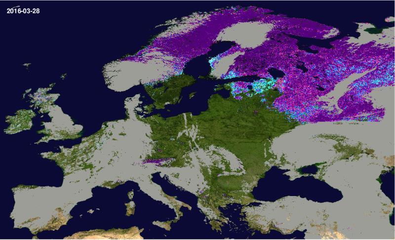
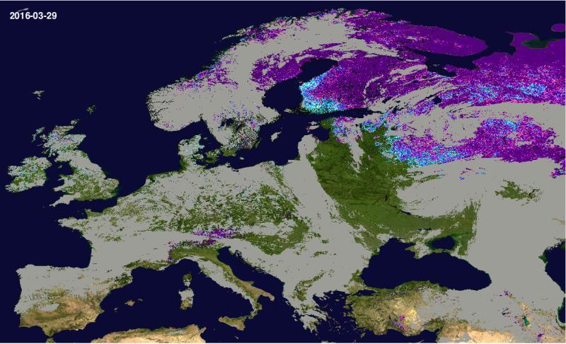


15 1-10 % % % % % % % % % % Clouds Snow Free Water Permanent Ice Copernicus Training & Info Session, Nov 2016, Helsinki, Finland Polar Night 15
 Partial snow/white ice cover 3) Open water full snow cover partial snow/ white ice cover Simple reference reflectance algorithm Reference reflectances based on comparing in-situ measurements")
16 Reflectance Ice off date In-situ Snow depth Cryosphere products: Lake Ice Extent (SE) Operational for Baltic Sea area; development on-going for NH Three class classification: 1) Fully snow covered ice 2) Partial snow/white ice cover 3) Open water full snow cover partial snow/ white ice cover Simple reference reflectance algorithm Reference reflectances based on comparing in-situ measurements of snow depth on ice and ice phenology observations Snow detection based on SCAmod FSCalgorithm (Metsämäki et al. 2005, 2012) Currently applies MODIS data - in future Sentinel-3 SLSTR Retrieval hindered by clouds and polar night Cloud screening: SYKE developed SCDA 2.0 algorithm Time clear ice/ columnar ice open water Copernicus Training & Info Session, Nov 2016, Helsinki, Finland 16


17 Copernicus Training & Info Session, Nov 2016, Helsinki, Finland 17
 Northern-Hemisphere Snow Extent (SE) Pan-European Snow Extent (SE) Lake Ice Extent")
, ENVEO and Finnish Environment Institute (SYKE) are producing daily near-real")


18 Cryosphere products - Summary Snow Extent, Snow Water Equivalent, Lake Ice Extent (by FMI, ENVEO, SYKE) Northern-Hemisphere Snow Extent (SE) Pan-European Snow Extent (SE) Lake Ice Extent (LIE) for Baltic Sea area Northern Hemisphere SWE Pan-European SWE Finnish Meteorological Institute (FMI), ENVEO and Finnish Environment Institute (SYKE) are producing daily near-real time products on snow cover and lake ice for Pan-European domain and Northern Hemisphere. The products have a long-standing legacy from ESA GlobSnow and EC Cryoland projects. The cryosphere products have been developed in close collaboration between FMI, ENVEO and SYKE and will be produced jointly at the FMI production centre. Copernicus Training & Info Session, Nov 2016, Helsinki, Finland 18
 Datapool: automated, direct HTTP access in native format Copernicus Training & Info Session, 21-22 Nov 2016, Helsinki, Finland 19")
19 Product ordering & download Asynchronous ordering: notification when order is ready Subscription to upcoming products Options to customize (spatial window, file format, projection, layer selection) Datapool: automated, direct HTTP access in native format Copernicus Training & Info Session, Nov 2016, Helsinki, Finland 19
20 Usage in Q Online access ~25% actively download majority European gaps in East & North Europe EUMETCast: ~ 600 users, 90% of African (MESA) main potential in Europe Copernicus Training & Info Session, Nov 2016, Helsinki, Finland 20

21 Usage in Q (cont d) Copernicus Training & Info Session, Nov 2016, Helsinki, Finland 21

 Consortium: Evaluation & User group led by Spacebel (Belgium) Consortium: Hot-spot mapping led by e-geos SpA")
22 Thanks for your attention! Implementation coordination Institutional Coordination Website: Helpdesk: Consortium: Production of vegetation & energy products led by VITO (Belgium) Consortium: Production of Cryosphere & water products led by CLS (France) Operations partners: Associates: Consortium: Distribution & support led by VITO (Belgium) Consortium: Evaluation & User group led by Spacebel (Belgium) Consortium: Hot-spot mapping led by e-geos SpA (Italy) Consortium: Hot-spot validation led by IGN (France) Copernicus Training & Info Session, Nov 2016, Helsinki, Finland 22
Examples on Sentinel data applications in Finland, possibilities, plans and how NSDC will be utilized - Snow
 Examples on Sentinel data applications in Finland, possibilities, plans and how NSDC will be utilized - Snow Kari Luojus, Jouni Pulliainen, Jyri Heilimo, Matias Takala, Juha Lemmetyinen, Ali Arslan, Timo
FMI Arctic Space Centre. Jyri Heilimo Finnish Meteorological Institute
 FMI Arctic Space Centre Jyri Heilimo Finnish Meteorological Institute FMI - Arctic Space Center Studies of atmospheric phenomena and their interaction with biosphere and cryosphere in high latitudes Hydrology,
Global SWE Mapping by Combining Passive and Active Microwave Data: The GlobSnow Approach and CoReH 2 O
 Global SWE Mapping by Combining Passive and Active Microwave Data: The GlobSnow Approach and CoReH 2 O April 28, 2010 J. Pulliainen, J. Lemmetyinen, A. Kontu, M. Takala, K. Luojus, K. Rautiainen, A.N.
Environmental observations over Arctic areas potential for monitoring the spread of infectious diseases
 Environmental observations over Arctic areas potential for monitoring the spread of infectious diseases Ali Nadir Arslan ali.nadir.arslan@fmi.fi ARCTIC RESEARCH DEAPARTMENT / FMI ARKTIKO Seminar, Helsinki,
ESA GlobSnow - project overview
 ESA GlobSnow - project overview GCW 1 st Implementation meeting Geneve, 23 Nov. 2011 K. Luojus & J. Pulliainen (FMI) + R. Solberg (NR) Finnish Meteorological Institute 1.12.2011 1 ESA GlobSnow ESA-GlobSnow
Application of EO for Environmental Monitoring at the Finnish Environment Institute
 Application of EO for Environmental Monitoring at the Finnish Environment Institute Data Processing (CalFin) and Examples of Products Markus Törmä Finnish Environment Institute SYKE markus.torma@ymparisto.fi
Remote sensing of snow at SYKE Sari Metsämäki
 Remote sensing of snow at SYKE 2011-01-21 Sari Metsämäki Activities in different projects Snow extent product in ESA DUE-project GlobSnow Long term datasets (15-30 years) on Snow Extent (SE) and Snow Water
Intercomparison of Snow Extent Products from Earth Observation Data
 Intercomparison of Snow Extent Products from Earth Observation Data, Elisabeth Ripper, Gabriele Bippus, Helmut Rott FMI Richard Fernandes Kari Luojus Sari Metsämäki Dorothy Hall David Robinson Bojan Bojkov
C o p e r n i c u s L a n d M o n i t o r i n g S e r v i c e
 C o p e r n i c u s L a n d M o n i t o r i n g S e r v i c e Integration into existing Snow and Ice Services and draft product specifications Annett BARTSCH b.geos Copernicus High Resolution Snow and
The indicator can be used for awareness raising, evaluation of occurred droughts, forecasting future drought risks and management purposes.
 INDICATOR FACT SHEET SSPI: Standardized SnowPack Index Indicator definition The availability of water in rivers, lakes and ground is mainly related to precipitation. However, in the cold climate when precipitation
Snow Cover Applications: Major Gaps in Current EO Measurement Capabilities
 Snow Cover Applications: Major Gaps in Current EO Measurement Capabilities Thomas NAGLER ENVEO Environmental Earth Observation IT GmbH INNSBRUCK, AUSTRIA Polar and Snow Cover Applications User Requirements
Assimilation of GlobSnow Data in HIRLAM. Suleiman Mostamandy Kalle Eerola Laura Rontu Katya Kourzeneva
 Assimilation of GlobSnow Data in HIRLAM Suleiman Mostamandy Kalle Eerola Laura Rontu Katya Kourzeneva 10/03/2011 Contents Introduction Snow from satellites Globsnow Other satellites The current study Experiment
Remote Sensing products and global datasets. Joint Research Centre, European Commission
 Remote Sensing products and global datasets Joint Research Centre, European Commission Setting the stage. Needs and requirements for integrated approach(es) for land degradation assessment. in Special
Status of EUMETSAT Operational Services & EUMETCast Africa Dissemination Baseline Updates
 Status of EUMETSAT Operational Services & EUMETCast Africa Dissemination Baseline Updates Sally Wannop User Relations Manager 1 8th WMO RAIDEG meeting 1-2 November 2017 # 951881 Overview EUMETCast Overview
National Satellite Data Centre and Finnish Sentinel Collaborative Ground Segment. Jyri Heilimo Finnish Meteorological Instute
 National Satellite Data Centre and Finnish Sentinel Collaborative Ground Segment Jyri Heilimo Finnish Meteorological Instute Sodankylä National Satellite Data Centre National satellite data centre providing
ASSESSMENT OF NORTHERN HEMISPHERE SWE DATASETS IN THE ESA SNOWPEX INITIATIVE
 ASSESSMENT OF NORTHERN HEMISPHERE SWE DATASETS IN THE ESA SNOWPEX INITIATIVE Kari Luojus 1), Jouni Pulliainen 1), Matias Takala 1), Juha Lemmetyinen 1), Chris Derksen 2), Lawrence Mudryk 2), Michael Kern
U s i n g t h e E S A / E U M E T C A S T N a v i g a t o r s
 U s i n g t h e E S A / E U M E T C A S T N a v i g a t o r s Copernicus User Uptake Information Sessions Copernicus EU Copernicus EU Copernicus EU www.copernicus.eu I N T R O D U C T I O N O F U S E C
The use of earth observation technology to improve the characterization of ice and snow
 The use of earth observation technology to improve the characterization of ice and snow Swedish Meteorological and Hydrological Institute (SMHI) Outline: EO and ice/snow CryoLand North Hydrology EO in
The Copernicus Climate Change (C3) service: State of play
 service: State of play") Enterprise and Industry The Copernicus Climate Change (C3) service: State of play B. Pinty (a) & J-N. Thépaut (b) (a) Copernicus G.2 unit (b) ECMWF CCI October2014 Legal frame & MS consultations Publica6on
Enterprise and Industry The Copernicus Climate Change (C3) service: State of play B. Pinty (a) & J-N. Thépaut (b) (a) Copernicus G.2 unit (b) ECMWF CCI October2014 Legal frame & MS consultations Publica6on
EUMETSAT SAF NETWORK. Lothar Schüller, EUMETSAT SAF Network Manager
 1 EUMETSAT SAF NETWORK Lothar Schüller, EUMETSAT SAF Network Manager EUMETSAT ground segment overview METEOSAT JASON-2 INITIAL JOINT POLAR SYSTEM METOP NOAA SATELLITES CONTROL AND DATA ACQUISITION FLIGHT
The ESA SnowPex project and an introduction to the APVE workshops
 The ESA SnowPex project and an introduction to the APVE workshops Bojan R. Bojkov Head Sensor Performance, Products and Algorithms Directorate of Earth Observation Programmes European Space Agency ESA/ESRIN
ADVANCEMENTS IN SNOW MONITORING
 Polar Space Task Group ADVANCEMENTS IN SNOW MONITORING Thomas Nagler, ENVEO IT GmbH, Innsbruck, Austria Outline Towards a pan-european Multi-sensor Snow Product SnowPEx Summary Upcoming activities SEOM
Copernicus Land Monitoring Services
 Copernicus Land Monitoring Services TASK 3: CONTINUATION OF SNOW & ICE TASK D 3.2: Summary Report to Support EEA Date: June 2017 Version: 1.0 Prepared by: Marketa Jindrova (GISAT) Joan Bauzà Llinàs Alaitz
Global Snow Monitoring for Climate Research. Final Report (FR) EUROPEAN SPACE AGENCY STUDY CONTRACT REPORT ESRIN Contract 21703/08/I-EC
 EUROPEAN SPACE AGENCY STUDY CONTRACT REPORT ESRIN Contract 21703/08/I-EC") Global Snow Monitoring for Climate Research Final Report (FR) EUROPEAN SPACE AGENCY STUDY CONTRACT REPORT ESRIN Contract DELIVERABLE 3.5 PREPARED BY Kari LUOJUS, Jouni PULLIAINEN, Matias TAKALA, Juha LEMMETYINEN
Global Snow Monitoring for Climate Research Final Report (FR) EUROPEAN SPACE AGENCY STUDY CONTRACT REPORT ESRIN Contract DELIVERABLE 3.5 PREPARED BY Kari LUOJUS, Jouni PULLIAINEN, Matias TAKALA, Juha LEMMETYINEN
Soil frost from microwave data. Kimmo Rautiainen, Jouni Pulliainen, Juha Lemmetyinen, Jaakko Ikonen, Mika Aurela
 Soil frost from microwave data Kimmo Rautiainen, Jouni Pulliainen, Juha Lemmetyinen, Jaakko Ikonen, Mika Aurela Why landscape freeze/thaw? Latitudinal variation in mean correlations (r) between annual
Assimilation of satellite derived soil moisture for weather forecasting
 Assimilation of satellite derived soil moisture for weather forecasting www.cawcr.gov.au Imtiaz Dharssi and Peter Steinle February 2011 SMOS/SMAP workshop, Monash University Summary In preparation of the
EUMETSAT s Support to Climate Services and User Support. Joachim Saalmüller
 EUMETSAT s Support to Climate Services and User Support Joachim Saalmüller 1 User Forum in Africa September 2016 Outline of my talk EUMETSAT in support of climate services Exploring our data and subscribing
Land Monitoring Core Service Implementation Group (LMCS IG) - Results and Outlook
 - Results and Outlook") Land Monitoring Core Service Implementation Group (LMCS IG) - Results and Outlook Pr. Dietmar Grünreich, President of BKG, Germany Chairman of the GMES LMCS IG Outline 1 Introduction 2 Preparatory Projects
Land Monitoring Core Service Implementation Group (LMCS IG) - Results and Outlook Pr. Dietmar Grünreich, President of BKG, Germany Chairman of the GMES LMCS IG Outline 1 Introduction 2 Preparatory Projects
Copernicus Today and Tomorrow GEO Week Group on Earth Observation Geneva, 16 January 2014 The Copernicus Space Infrastructure
 Copernicus Today and Tomorrow GEO Week Group on Earth Observation Geneva, 16 January 2014 The Copernicus Space Infrastructure Thomas Beer, Policy Coordinator, Copernicus Space Office, ESA-ESRIN, Frascati
SIMULATION OF SPACEBORNE MICROWAVE RADIOMETER MEASUREMENTS OF SNOW COVER FROM IN-SITU DATA AND EMISSION MODELS
 SIMULATION OF SPACEBORNE MICROWAVE RADIOMETER MEASUREMENTS OF SNOW COVER FROM IN-SITU DATA AND EMISSION MODELS Anna Kontu 1 and Jouni Pulliainen 1 1. Finnish Meteorological Institute, Arctic Research,
EUMETSAT SAF NETWORK. Lothar Schüller, EUMETSAT SAF Network Manager
 1 EUMETSAT SAF NETWORK Lothar Schüller, EUMETSAT SAF Network Manager EUMETSAT ground segment overview METEOSAT JASON-2 INITIAL JOINT POLAR SYSTEM METOP NOAA SATELLITES CONTROL AND DATA ACQUISITION FLIGHT
LIFE12 ENV/FIN/ st summary report of snow data 30/09/2014
 LIFE Project Number 1st summary report of snow data Reporting Date 30/09/2014 LIFE+ PROJECT NAME or Acronym Climate change indicators and vulnerability of boreal zone applying innovative observation and
European Space Agency
 Guidelines - Guidelines how/when to interact during the WebEx session: - Due to the number of attendees, please keep always your webcam and microphone switched-off - You can use anytime the chat to all
ESA snow monitoring initiatives
 ESA snow monitoring initiatives Bojan R. Bojkov Head, Sensor Performance, Products and Algorithms (SPPA) Directorate of Earth Observation Programmes ESA/ESRIN Why snow at ESA? Downstream services ESA instrument
NSIDC Metrics Report. Lisa Booker February 9, 2012
 NSIDC Metrics Report Lisa Booker February 9, 2012 ACSI Scores 2011 ACSI survey summary Sent to 5458 users; increased number of users contacted NSIDC response rate was 10%, up 1% from last year. NSIDC Customer
H SAF SATELLITE APPLICATION FACILITY ON SUPPORT TO OPERATIONAL HYDROLOGY AND WATER MANAGEMENT EUMETSAT NETWORK OF SATELLITE APPLICATION FACILITIES
 H SAF SATELLITE APPLICATION FACILITY ON SUPPORT TO OPERATIONAL HYDROLOGY AND WATER MANAGEMENT EUMETSAT NETWORK OF SATELLITE APPLICATION FACILITIES H-SAF: SATELLITE PRODUCTS FOR OPERATIONAL HYDROLOGY H-SAF
ESM-Snow model intercomparison
 Grand Challenge Cryosphere in a Changing Climate ESM-Snow model intercomparison C. Derksen, G. Krinner, R. Essery, M. Flanner, S. Hagemann, H. Rott Motivation Rapid snow extent changes in NH Climate change
ESA Status Report. ET-SAT-11, WMO, Geneva, CH, 4 April Prepared by Earth Observation Programmes Directorate
 ESA Status Report ET-SAT-11, WMO, Geneva, CH, 4 April 2017 Prepared by Earth Observation Programmes Directorate Presented by Ivan Petiteville, ESA, Earth Observation Programmes Issue/Revision: 0.0 Reference:
CopernicusEU. the EU's Earth Observation Programme. Sara Zennaro Atre Delegation of the European Union to Japan
 Copernicus the EU's Earth Observation Programme Sara Zennaro Atre Delegation of the European Union to Japan Status Overview, Sept 2016 & Ocean Policies Seminar 4 October 2016 ollow us on: Copernicus EU
Snow and Albedo as Essential Climate Variables
 Snow and Albedo as Essential Climate Variables Jason E. Box Geological Survey of Denmark and Greenland Copenhagen, Denmark current (alphabetical) national collaboration 1.Liège, Belgium 2.Copenhagen, Denmark
H-SAF Snow products and their use in applications. Matias Takala
 H-SAF Snow products and their use in applications Matias Takala Matias.takala@fmi.fi H-SAF snow products H-SAF: EUMETSAT funded satellite application facility (SAF) for Support to Operational Hydrology
THE USE OF MERIS SPECTROMETER DATA IN SEASONAL SNOW MAPPING
 THE USE OF MERIS SPECTROMETER DATA IN SEASONAL SNOW MAPPING Miia Eskelinen, Sari Metsämäki The Finnish Environment Institute Geoinformatics and Land use division P.O.Box 140, FI 00251 Helsinki, Finland
GlobSnow-2 Final Report
 Global Snow Monitoring for Climate Research GlobSnow-2 Final Report EUROPEAN SPACE AGENCY STUDY CONTRACT REPORT ESRIN Contract PREPARED BY KARI LUOJUS, JOUNI PULLIAINEN, MATIAS TAKALA, JUHA LEMMETYINEN,
Climate Change Service
 Service Metadata for the Data Store Dick Dee, ECMWF C3S: data + expertise + operational Open and free access to climate data (observations, reanalyses, model predictions) Tools and best scientific practices
Copernicus Space Component Status & Evolution
 Copernicus Space Component Status & Evolution ESCAP, Bangkok 09 October 2017 Simon Jutz Head of the ESA Copernicus Space Office Directorate of Earth Observation Programmes 28 satellites in development
ECMWF. ECMWF Land Surface modelling and land surface analysis. P. de Rosnay G. Balsamo S. Boussetta, J. Munoz Sabater D.
 Land Surface modelling and land surface analysis P. de Rosnay G. Balsamo S. Boussetta, J. Munoz Sabater D. Vasiljevic M. Drusch, K. Scipal SRNWP 12 June 2009 Slide 1 Surface modelling (G. Balsamo) HTESSEL,
Determination of the snow melting intensity in nowadays climate conditions by example of the Neman river basin
 Determination of the snow melting intensity in nowadays climate conditions by example of the Neman river basin Alexander Volchak, Dmitriy Kostiuk, Dmitriy Petrov, Nikolay Sheshko Brest State Technical
Arctic Regional Ocean Observing System Arctic ROOS Report from 2012
 Arctic Regional Ocean Observing System Arctic ROOS Report from 2012 By Stein Sandven Nansen Environmental and Remote Sensing Center (www.arctic-roos.org) Focus in 2012 1. Arctic Marine Forecasting Center
Report. Northern Africa. RAIDEG-8, 1-2 Nov 2017
 Report Northern Africa RAIDEG-8, 1-2 Nov 2017 Report Northern Africa RAIDEG-8, 1-2 Nov 2017 Important Note: Formal letters have been sent from the PR of Morocco with WMO to PRs of Algeria, Tunisia, Libya
ECMWF. ECMWF Land Surface Analysis: Current status and developments. P. de Rosnay M. Drusch, K. Scipal, D. Vasiljevic G. Balsamo, J.
 Land Surface Analysis: Current status and developments P. de Rosnay M. Drusch, K. Scipal, D. Vasiljevic G. Balsamo, J. Muñoz Sabater 2 nd Workshop on Remote Sensing and Modeling of Surface Properties,
Steve Colwell. British Antarctic Survey
 Global Climate Observing System (GCOS) Steve Colwell British Antarctic Survey Goal and Structure of GCOS The Goal of GCOS is to provide continuous, reliable, comprehensive data and information on the state
ESA s Earth Observation Programmes
 ESA s Earth Observation Programmes 2015 DRAGON Symposium Interlaken, 23 June 2015 Maurice Borgeaud Head of the Department Science, Applications, and Future Technologies ESA Earth Observation Programmes
Snow maps based on satellite data
 Snow maps based on satellite data SNAPS Work Package 4: Final report on WP 4 Prepared by Eirik Malnes, Norut, Norway Kari Luojus, Jaakko Ikonen and Matias Takala, FMI, Finland Hrobjartur Thorsteinsson
The Satellite Snow Product Intercomparison and Evaluation Experiment Objectives, Status, Expected Results
 SnowPEx Satellite Snow Product Intercomparison and Evaluation Experiment (6/2014 5/2016) The Satellite Snow Product Intercomparison and Evaluation Experiment Objectives, Status, Expected Results Thomas
Regional Activities and Perspectives on GCW: Relevant FMI Activities at Northern Finland and Suggestions for GCW Monitoring Site Requirements
 Regional Activities and Perspectives on GCW: Relevant FMI Activities at Northern Finland and Suggestions for GCW Monitoring Site Requirements Jouni Pulliainen 21 November 2011 Suggestions for GCW monitoring
Integration of remotely sensed data into a GIS of soil resources
 UN / Austria / ESA Symposium Space Tools and Solutions for Monitoring the Atmosphere and Land Cover Integration of remotely sensed data into a GIS of soil resources Diana Hanganu,, Roxana Vintila ICPA
Sentinel-1 Mission Status
 Sentinel-1 Mission Status Pierre Potin, Sentinel-1 Mission Manager, ESA Luca Martino, Technical Support Engineer, ESA... and the Sentinel-1 operations team PSTG SAR Coordination Working Group 14 December
C o p e r n i c u s a n d W I G O S
 C o p e r n i c u s a n d W I G O S Jean-Noël Thépaut & Mark Dowell 24 October 2017 GEO XIV, Washington DC, 23-28 October 2017 T h e C o p e r n i c u s P r o g r a m m e Copernicus is the European Union
The Role of EO Consultants and SMEs within GMES. Geoff Smith
 The Role of EO Consultants and SMEs within GMES Geoff Smith Enable clients to deliver useful, accurate and reliable environmental information from EO. Positioned to bridge the gaps between technology development,
Land Data Assimilation for operational weather forecasting
 Land Data Assimilation for operational weather forecasting Brett Candy Richard Renshaw, JuHyoung Lee & Imtiaz Dharssi * *Centre Australian Weather and Climate Research Contents An overview of the Current
Space research. Horizon Work Programme. "Countdown to Horizon 2020 Space" Earth Observation topics. Brussels, 12 December 2013
 Space research Horizon 2020 - Work Programme "Countdown to Horizon 2020 Space" Earth Observation topics Brussels, 12 December 2013 richard.gilmore@ec.europa.eu Table of contents FP/Copernicus - general
EuroGEOSS Protected Areas Pilot
 EuroGEOSS Protected Areas Pilot Max Craglia European Commission Joint Research Centre Part 1: the present MyNatura2000 Mobile app. Awareness raising & volunteered data collection. Natura2000 covers 18%
Permafrost: Earth Observation Applications: Introduction
 Polar Meeting 3 Permafrost: Earth Observation Applications: Introduction Mark Drinkwater CNES, Paris, 22 23 May, 2013 Remote Sensing of Permafrost which Remote Sensing products? applicability to Permafrost
Arctic Observing Systems Challenges, New opportunities and Integration
 Arctic Observing Systems Challenges, New opportunities and Integration Japan Norway Arctic Science Week 03 June 2016 By Stein Sandven, NERSC Building an integrated Arctic Observing System Need to collect,
Validation of satellite derived snow cover data records with surface networks and m ulti-dataset inter-comparisons
 Validation of satellite derived snow cover data records with surface networks and m ulti-dataset inter-comparisons Chris Derksen Climate Research Division Environment Canada Thanks to our data providers:
EO4SEE - THE PATHFINDER OF OPERATIONAL SATELLITE MONITORING FOR THE REGION OF THE BLACK SEA AND CENTRAL EUROPE
 EO4SEE: Pathfinder assessment for regional high volume data access, processing and information service delivery platforms - South East Region EO4SEE - THE PATHFINDER OF OPERATIONAL SATELLITE MONITORING
Intercomparison and Evaluation Experiment
 The SnowPEx Satellite Satellite Snow Product Intercomparison Snow and Evaluation Experiment Product (6/2014 5/2016) Intercomparison and Evaluation Experiment Report to PSTG WG Meeting # 5 DLR, 5 Oct 2015
EUMETSAT STATUS AND PLANS
 1 EUM/TSS/VWG/15/826793 07/10/2015 EUMETSAT STATUS AND PLANS François Montagner, Marine Applications Manager, EUMETSAT WMO Polar Space Task Group 5 5-7 October 2015, DLR, Oberpfaffenhofen PSTG Strategic
Satellite-based Lake Surface Temperature (LST) Homa Kheyrollah Pour Claude Duguay
 Homa Kheyrollah Pour Claude Duguay") Satellite-based Lake Surface Temperature (LST) Homa Kheyrollah Pour Claude Duguay Lakes in NWP models Interaction of the atmosphere and underlying layer is the most important issue in climate modeling
Satellite-based Lake Surface Temperature (LST) Homa Kheyrollah Pour Claude Duguay Lakes in NWP models Interaction of the atmosphere and underlying layer is the most important issue in climate modeling
The Canadian Precipitation Analysis (CaPA) and the Canadian Land Data Assimilation System (CaLDAS)
 and the Canadian Land Data Assimilation System (CaLDAS)") The Canadian Precipitation Analysis (CaPA) and the Canadian Land Data Assimilation System (CaLDAS) Vincent Fortin (and many collaborators) Division de la recherche en météorologie Environnement en Changement
The Canadian Precipitation Analysis (CaPA) and the Canadian Land Data Assimilation System (CaLDAS) Vincent Fortin (and many collaborators) Division de la recherche en météorologie Environnement en Changement
Aerosol forecasting and assimilation at ECMWF: overview and data requirements
 Aerosol forecasting and assimilation at ECMWF: overview and data requirements Angela Benedetti Luke Jones ECMWF Acknowledgements: Jean-Jacques Morcrette, Carole Peubey, Olaf Stiller, and Richard Engelen
A BRIEF INTRODUCTION TO COPERNICUS AND CAMS
 A BRIEF INTRODUCTION TO COPERNICUS AND CAMS Juan Garcés de Marcilla Director of Copernicus Services European Centre for Medium-Range Weather Forecasts Copernicus EU Copernicus EU Copernicus EU www.copernicus.eu
User requirements for the snow and land ice services CryoLand
 doi:10.5194/tc-9-1191-2015 Author(s) 2015. CC Attribution 3.0 License. User requirements for the snow and land ice services CryoLand E. Malnes 1, A. Buanes 1, T. Nagler 2, G. Bippus 2, D. Gustafsson 3,
sentinel-3 A BIGGER PICTURE FOR COPERNICUS
 sentinel-3 A BIGGER PICTURE FOR COPERNICUS SATELLITES TO SERVE By providing a set of key information services for a wide range of practical applications, Europe s Copernicus programme has been put in place
EUMETSAT Climate Activities
 EUMETSAT Climate Activities Jörg Schulz EUMETSAT s Role in Climate Monitoring EUMETSAT has a prominent role in the world for providing services relevant to climate: EUMETSAT maintains some of the longest
A Facility for Producing Consistent Remotely Sensed Biophysical Data Products of Australia
 TERRESTRIAL ECOSYSTEM RESEARCH NETWORK - AusCover - A Facility for Producing Consistent Remotely Sensed Biophysical Data Products of Australia June, 2011 Mervyn Lynch Professor of Remote Sensing Curtin
Assimilation of Globsnow data into HIRLAM. Mostamandy Suleiman Sodankyla August 2011
 Assimilation of Globsnow data into HIRLAM Mostamandy Suleiman Sodankyla August 2011 Motivation Small number of observations (especially in eastern Europe and Russia) 00 cm of snow problem Non-uniform in
I&CLC2000 in support to new policy initiatives (INSPIRE, GMES,..)
") I&CLC2000 in support to new policy initiatives (INSPIRE, GMES,..) Manfred Grasserbauer, Director Joint Research Centre Institute for Environment and Sustainability 1 IMAGE 2000 European mosaic of satellite
I&CLC2000 in support to new policy initiatives (INSPIRE, GMES,..) Manfred Grasserbauer, Director Joint Research Centre Institute for Environment and Sustainability 1 IMAGE 2000 European mosaic of satellite
Status of ESA EO Programmes
 Status of ESA EO Programmes 54 th ESSC Plenary Meeting 24 November 2017 Maurice Borgeaud, ESA Head of the ESA Earth Observation Science, Applications and Climate Department Issue/Revision: 0.0 Reference:
Remote Sensing of SWE in Canada
 Remote Sensing of SWE in Canada Anne Walker Climate Research Division, Environment Canada Polar Snowfall Hydrology Mission Workshop, June 26-28, 2007 Satellite Remote Sensing Snow Cover Optical -- Snow
EUMETSAT Activities Related to Climate
 EUMETSAT Activities Related to Climate Jörg Schulz joerg.schulz@eumetsat.int Slide: 1 What we do USER REQUIREMENTS European National Meteorological Services Operating Agency! European Space Industry Private
Climate Change. Climate Change Service
 Service The C3S m ission To support European adaptation and mitigation policies by: Providing consistent and authoritative information about climate Building on existing capabilities and infrastructures
ISO MODIS NDVI Weekly Composites for Canada South of 60 N Data Product Specification
 ISO 19131 MODIS NDVI Weekly Composites for South of 60 N Data Product Specification Revision: A Data specification: MODIS NDVI Composites for South of 60 N - Table of Contents - 1. OVERVIEW... 3 1.1. Informal
Climate Models and Snow: Projections and Predictions, Decades to Days
 Climate Models and Snow: Projections and Predictions, Decades to Days Outline Three Snow Lectures: 1. Why you should care about snow 2. How we measure snow 3. Snow and climate modeling The observational
Essential Biodiversity Variables Workshop
 Essential Biodiversity Variables Workshop Dr. Maurice Borgeaud ESA Earth Observation Programmes ESA ESRIN 27 February 2012 The European Space Agency To provide for and promote, for exclusively peaceful
INTAROS Integration of the existing Arctic observing systems into a common data frame. Roberta Pirazzini, Finnish Meteorological Institute
 INTAROS Integration of the existing Arctic observing systems into a common data frame Roberta Pirazzini, Finnish Meteorological Institute Outline 1. Overview of the INTAROS project 2. Overview of the INTAROS
P r o d u c t p o r t f o l i o a n d d a t a a c c e s s
 P r o d u c t p o r t f o l i o a n d d a t a a c c e s s Copernicus Environment Service Copernicus EU Copernicus EU Copernicus EU www.copernicus.eu I N T R O D U C T I O N O F U S E C A S E User Uptake
Group on Earth Observations (GEO) Cold Regions Work Plan Item WA-01-C3
 Cold Regions Work Plan Item WA-01-C3") EC Panel of Experts on Polar Observations, Research and Services Group on Earth Observations (GEO) Cold Regions Work Plan Item WA-01-C3 Barbara J. Ryan Secretariat Director Lanzhou, China 13 March 2013
EC Panel of Experts on Polar Observations, Research and Services Group on Earth Observations (GEO) Cold Regions Work Plan Item WA-01-C3 Barbara J. Ryan Secretariat Director Lanzhou, China 13 March 2013
Climate Change and Water Cycle: Effect to Water Resources and their Utilization in Finland (CLIMWATER)
") Climate Change and Water Cycle: Effect to Water Resources and their Utilization in Finland (CLIMWATER) Final Seminar of the Ficca Programme 2.12.2014 J. Pulliainen (FMI), L. Backman, J. Kaurola, T. Olsson,
Climate Change and Water Cycle: Effect to Water Resources and their Utilization in Finland (CLIMWATER) Final Seminar of the Ficca Programme 2.12.2014 J. Pulliainen (FMI), L. Backman, J. Kaurola, T. Olsson,
Copernicus Space Component
 Copernicus Space Component Core and Collaborative Ground Segment, Operations Concept, Data Access Simon.Jutz (@esa.int) Head, Copernicus Space Office European Space Agency, Earth Observation Programmes
The role of soil moisture in influencing climate and terrestrial ecosystem processes
 1of 18 The role of soil moisture in influencing climate and terrestrial ecosystem processes Vivek Arora Canadian Centre for Climate Modelling and Analysis Meteorological Service of Canada Outline 2of 18
Helsinki Testbed - a contribution to NASA's Global Precipitation Measurement (GPM) mission
 mission") Helsinki Testbed - a contribution to NASA's Global Precipitation Measurement (GPM) mission Ubicasting workshop, September 10, 2008 Jarkko Koskinen, Jarmo Koistinen, Jouni Pulliainen, Elena Saltikoff, David
Helsinki Testbed - a contribution to NASA's Global Precipitation Measurement (GPM) mission Ubicasting workshop, September 10, 2008 Jarkko Koskinen, Jarmo Koistinen, Jouni Pulliainen, Elena Saltikoff, David
WMO RA VI Hydrological Forum. H-SAF: from products to end users
 WMO RA VI Hydrological Forum Oslo, 20 September 2016 H-SAF: from products to end users Lt. Col. Francesco Zauli ITAF-COMet H-SAF Project Manager 1 H-SAF Objectives Satellite Application Facility in Support
The Application of Satellite Data i n the Global Surface Data Assimil ation System at KMA
 The Application of Satellite Data i n the Global Surface Data Assimil ation System at KMA Mee-Ja Kim, Hae-Mi Noh, SeiYoung Park, Sangwon Joo KMA/NIMS kimmee74@korea.kr 14 March, 2016 The 4th Workshop on
Copernicus Marine Environment Monitoring Service
 Copernicus Marine Environment Monitoring Service Mercator Ocean March 2017 Implemented by Entrusted to Mercator Ocean by the European Commission Cliquez et modifiez le titre French non-profit company Owned
Evaluation of remotely sensed and modelled soil moisture products using global ground-based in situ observations
 Evaluation of remotely sensed and modelled soil moisture products using global ground-based in situ observations C. Albergel (1), P. de Rosnay (1), G. Balsamo (1),J. Muñoz-Sabater(1 ), C. Gruhier (2),
ASimultaneousRadiometricand Gravimetric Framework
 Towards Multisensor Snow Assimilation: ASimultaneousRadiometricand Gravimetric Framework Assistant Professor, University of Maryland Department of Civil and Environmental Engineering September 8 th, 2014
EUMETSAT Data and Services for Climate Services and Research. Jörg Schulz
 EUMETSAT Data and Services for Climate Services and Research Jörg Schulz 1 WMO Workshop on Operational Space-based Weather and Climate Extremes Monitoring, WMO HQ, Geneva, Switzerland, 15-17 February 2017
Sea ice charts and SAR for sea ice classification. Patrick Eriksson Juha Karvonen Jouni Vainio
 Sea ice charts and SAR for sea ice classification Patrick Eriksson Juha Karvonen Jouni Vainio ECMWF Ocean Workshop, 22-25 January 2018 Ice service from past to present Finland has long experience in ice
IPSENTINEL. The Collaborative Infrastructure for Sentinel Data in Portugal. IPSentinel
 IPSENTINEL The Collaborative Infrastructure for Sentinel Data in Portugal 1 MISSION The Directorate-General for the Territory Development (DGT) and the Portuguese Institute for the Sea and the Atmosphere