Remote Sensing products and global datasets. Joint Research Centre, European Commission
|
|
|
- Antonia Cain
- 5 years ago
- Views:
Transcription
1 Remote Sensing products and global datasets Joint Research Centre, European Commission
2 Setting the stage.
3 Needs and requirements for integrated approach(es) for land degradation assessment. in Special Issue in LD&D : April st UNCCD CST Special Scientific Conference Buenos Aires, Sep. 2009


4 Decision maker needs: to design policies & where and how to allocate resources, based on priorities Clear definition of what (impact) to monitor. E.g. persistent reduction or loss of biological/biomass productivity Clear, simple and timely information, economically justified Requires integration of environmental and socio-economic aspects
5 Stratified Integration of data.


6 Stratified Integration of global remote sensing datasets with land degradation causal factor and contextual local data


7 Analysis of converging evidence of change to indicate areas which are in problems by showing a decreased capacity to continue to produce ecosystem services
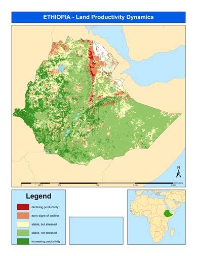
8 Remote Sensing data.


9 Slope over Global variables / Indicators satellite earth observation MODIS (ex. Oct13) LANDSAT 30m detail 1982 Timespan of the satellite data series NOAA-AVHRR 8km SPOT + PROBA-V 1km MODIS frequency NPP proxy Sum NDVI Gimms3G
10 Using remote sensing time-series.
 * Seasonal Sum NDVI * Annual Sum NDVI Annual Cyclic Production Permanent Veg.")
11 Phenology and Productive Variables (yearly) From vegetation index timeseries (NDVI, FAPAR) NOAA GIMMS 3G NDVI (29 years) SPOT VGT NDVI (15 years) * Seasonal Sum NDVI * Annual Sum NDVI Annual Cyclic Production Permanent Veg. Fraction Start of Season Season length Max of Season.

12 Phenology and Productive Variables (yearly) PHENOLO Decomposing the yearly NDVI/FAPAR curve into a number of yearly phenological and productivity variables showing land system dynamics Missing data handling: GAP > 2 decades NO -> cubic spine interpolation YES -> flag Iterative linear interpolation to days Reference time-series of vegetation index Savitzky Golay filter: savgol (N left, N right, degree) Nleft: 25 Nright: 25 degree of polynomial: 4 Reference time-series of vegetation index Reference time-series Reference time-series of vegetation index Reference time-series of vegetation index MIN 1 Std. 1 Std. SLE MIN MIN 1 Std. 1 Std. SLE MIN MIN 1 Std. 1 Std. SLE MIN J. D. J. D. J. D Method based on ( 365 SLE1999) + (365 SLE 2000) + (365 SLE 2001) L = 3 Reed, B., Brown, J.F., Vanderzee, D., Loveland, T.R., Merchant, J.W., Ohlen, D.O., Measuring phenological variability from satellite imagery. Journal of Vegetation Science 5: L L L L L L Calculation of integrals, dates and vegetation index values Vegetation phenology and productivity indicators and adapted/changed for global automated application in Ivits et al., Forward Moving Average Reference time-series Backward Moving Average Jan. Dec.
13 Phenology and Productive Variables (yearly) PHENOLO SPOT VGT NDVI Climatic zones over Europe
 From vegetation index")
 SPOT VGT")


14 Phenology and Productive Variables (yearly) From vegetation index timeseries (NDVI, FAPAR) NOAA GIMMS 3G NDVI (29 years) SPOT VGT NDVI (15 years) 15 years SPOT 1km based Long term CHANGE Map Steadiness Index + initial levels + class change * Seasonal Sum NDVI * Annual Sum NDVI Annual Cyclic Production Permanent Veg. Fraction Start of Season Season length Max of Season. Ecosystem Functional Types Stratification 5 years SPOT 1km Current STATUS Map: Local Scaling Land System Productive Capacity Dynamics Map
15 Based on annual/seasonal growing period NDVI sum - long term tendency ( ) - current performance ( ) 540 observations on Million points on land (1km SPOT data)
 Ivits, E., Cherlet, M., Sommer, S., Mehl, W. 2012a.")
16 References Cherlet M., Ivits E., Sommer S., Tóth G., Jones A., Montanarella L., Belward A., Land-Productivity Dynamics in Europe. Towards Valuation of Land Degradation in the EU. (accessed ) Ivits, E., Cherlet, M., Sommer, S., Mehl, W. 2012a. Ecosystem Functional Units characterized by satellite observed phenology and productivity gradients: a case study for Europe. Ecological Indicators 27, Ivits, E., Cherlet, M., Toth, G., Sommer, S., Mehl, W., Vogt, J., Micale, F., 2012b. Combining satellite derived phenology with climate data for climate change impact assessment. Global and Planetary Change 88 89, Based on annual/seasonal growing period NDVI sum - long term tendency ( ) - current performance ( ) 540 observations on Million points on land (1km SPOT data) Prince, S.D., Becker-Reshef, I., Rishmawi, K., Detection and mapping of long-term land degradation using local net production scaling: Application to Zimbabwe. Remote Sensing of Environment 113 (2009) Sommer, S., C. Zucca, A. Grainger, M. Cherlet, R. Zougmore, Y. Sokona, J. Hill, R. Della Peruta, J. Roehrig, G. Wang, 2011: Application of indicator systems for monitoring and assessment of desertification from national to global scales. Land Degrad. Develop. 22: (2011).


17 Stratified use and interpretation


18 LCC to cropland R² = Land Cover Change Areas with land cover change between 2000 and Area extents are exaggerated in order to be visible at presented scale From tree cover broadleaved deciduous R² = LPD 0.0 LPD LCC to Bare areas 300 Land Cover Change to agriculture Based on ESA Land Cover CCI (ESA-3epochas) R² = LPD

 Ivits et al.")
19 Climate effect on biomass productivity changes: Correlation between FaPAR and SPEI ( ) AVHRR GIMMS3g time-series ( ) Ivits et al. / Remote Sensing (2014)
20 COPERNICUS EO User Products.


21 Sentinel 1 SAR imaging All weather, day/night applications, interferometry Sentinel 2 Multispectral imaging Land applications: urban, forest, agriculture,.. Continuity of LANDSAT, SPOT, Sentinel 3 Ocean and global land monitoring : ocean color, vegetation, sea/land surface temperature, altimetry Sentinel 4 Geostationary atmospheric Atmospheric composition monitoring, trans-boundary pollution Sentinel 5 Low-orbit atmospheric Atmospheric composition monitoring (S5 Precursor launch in 2014) 2014, 2019+


22 COPERNICUS Core Services Services monitoring Earth systems Land Marine Atmosphere Emergency Security Climate Change


23 Data Policy Value added of an Operational Core Services Long term and reliable provision of products and services for downstream applications Delivery of fully validated products and services COPERNICUS: a public good. free and open access (Security restrictions may apply)


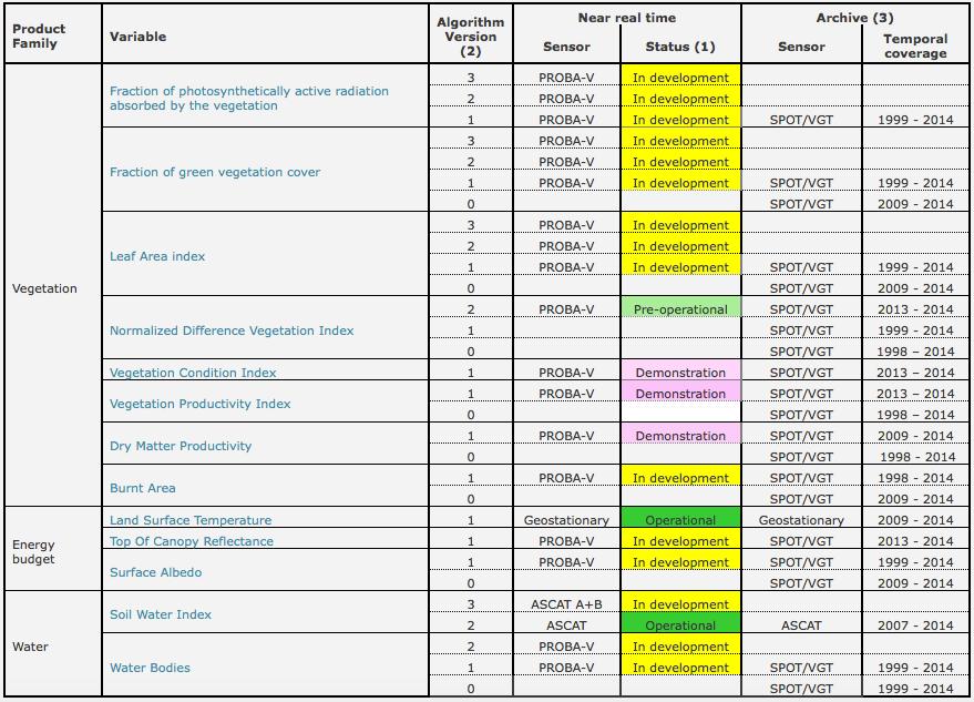
24 Land Service - Global Biophysical Variables

25 Land Service - Global Biophysical Variables


26 Global Land Service Portfolio SPOT PROBA-V * * * * * * Variable Temporal Coverage Temporal resolution Spatial coverage Spatial resolution Sensor Timeliness LAI/FAPAR/FCover 1999 present 10 days Global 1km SPOT/VGT 3 days NDVI/VCI/VPI 1999 present 10 days Global 1km SPOT/VGT 3 days Dry Matter Productivity 2009 present 10 days Global 1km SPOT/VGT 3 days Burnt Area 1998 present 1 day Global 1km SPOT/VGT 3 days TOC Reflectance 2013 present 10 days Global 1km SPOT/VGT 3 days Surface Albedo 1999 present 10 days Global 1km SPOT/VGT 3 days Land Surface Temperature 2009 present 1 hour Global 0.05 Σ Geo 1 day Soil Water Index 2007 present 1 day Global 0.1 Metop / ASCAT 1 day Water bodies 1999 present 10 days Global* 1km SPOT/VGT 3 days
27 Pre-operational Pre-operational Pre-operational

28 Global Surface Water layer: 30 years change Nanchang Lake Landsat archive, processing: Google Earth Engine JRC-Google, 2015
29 Global Surface Water layer: 30 years change Nanchang Lake Landsat archive, processing: Google Earth Engine JRC-Google, 2015
30 Global Surface Water layer: 30 years change Nanchang Lake Landsat archive, processing: Google Earth Engine JRC-Google, 2015
31 Global Surface Water layer: 30 years change Nanchang Lake 2014 Landsat archive, processing: Google Earth Engine JRC-Google, 2015
32 Cost effectiveness and capacity.


33

34

35

36
37 To conclude.
38 Use of remote sensing EO data: Advantages: Global, continuous and frequent coverage Adapted resolutions Many bio-physical variables, proven quality available CHANGE DETECTION sets of bio-physical indicators Limitations: one data group doesn t tell full story integrate societal data Need: Ensemble approaches Solid integration schemes


39 Thank you!
Copernicus Space Component Status & Evolution
 Copernicus Space Component Status & Evolution ESCAP, Bangkok 09 October 2017 Simon Jutz Head of the ESA Copernicus Space Office Directorate of Earth Observation Programmes 28 satellites in development
Emergency Management Service (EMS) mapping
 mapping") GMES Emergency Management Service (EMS) mapping Frédéric BASTIDE GMES unit, European Commission UN-SPIDER Expert Meeting: "Crowdsource Mapping for Disaster Risk Management and Emergency Response" 3-5 December,
GMES Emergency Management Service (EMS) mapping Frédéric BASTIDE GMES unit, European Commission UN-SPIDER Expert Meeting: "Crowdsource Mapping for Disaster Risk Management and Emergency Response" 3-5 December,
Copernicus Global Land Service
 Copernicus Global Land Service Cryosphere Products Kari Luojus on behalf the consortium Follow us on: Copernicus EU CopernicusEU www.copernicus.eu Copernicus Services Land Marine Atmosphere Emergency Security
Copernicus Overview and Emergency Management Service
 Copernicus Overview and Emergency Management Service Frédéric BASTIDE European Commission Open informal session of the United Nations Inter-Agency Meeting on Outer Space Activities 12 March 2013, Geneva
Arctic Observing Systems Challenges, New opportunities and Integration
 Arctic Observing Systems Challenges, New opportunities and Integration Japan Norway Arctic Science Week 03 June 2016 By Stein Sandven, NERSC Building an integrated Arctic Observing System Need to collect,
Infrastructure monitoring using SAR interferometry
 Infrastructure monitoring using SAR interferometry Hossein Nahavandchi Roghayeh Shamshiri Norwegian University of Science and Technology (NTNU), Department of Civil and Environmental Engineering Geodesy
Towards eenvironment Prague, March GMES Space Component. Josef Aschbacher Head, ESA GMES Space Office
 Towards eenvironment Prague, 25-27 March 2009 GMES Space Component Josef Aschbacher Head, ESA GMES Space Office Prague from Space Segment 2 05 Nov 2003 CNES 2003 GISAT 2007 ESA GSELAND GMES is an EU led
sentinel-2 COLOUR VISION FOR COPERNICUS
 sentinel-2 COLOUR VISION FOR COPERNICUS SATELLITES TO SERVE By providing a set of key information services for a wide range of practical applications, Europe s Copernicus programme is providing a step
UN COPUOS 52 nd session of the Scientific and Technical Subcommittee. COPERNICUS - an European Achievement. S. Jutz Head, ESA Copernicus Space Office
 UN COPUOS 52 nd session of the Scientific and Technical Subcommittee COPERNICUS - an European Achievement S. Jutz Head, ESA Copernicus Space Office 11 Feb 2015, Vienna 1 2 What is Copernicus? European
Copernicus Today and Tomorrow GEO Week Group on Earth Observation Geneva, 16 January 2014 The Copernicus Space Infrastructure
 Copernicus Today and Tomorrow GEO Week Group on Earth Observation Geneva, 16 January 2014 The Copernicus Space Infrastructure Thomas Beer, Policy Coordinator, Copernicus Space Office, ESA-ESRIN, Frascati
AGOG 485/585 /APLN 533 Spring Lecture 5: MODIS land cover product (MCD12Q1). Additional sources of MODIS data
. Additional sources of MODIS data") AGOG 485/585 /APLN 533 Spring 2019 Lecture 5: MODIS land cover product (MCD12Q1). Additional sources of MODIS data Outline Current status of land cover products Overview of the MCD12Q1 algorithm Mapping
AGOG 485/585 /APLN 533 Spring 2019 Lecture 5: MODIS land cover product (MCD12Q1). Additional sources of MODIS data Outline Current status of land cover products Overview of the MCD12Q1 algorithm Mapping
Land Monitoring Core Service Implementation Group (LMCS IG) - Results and Outlook
 - Results and Outlook") Land Monitoring Core Service Implementation Group (LMCS IG) - Results and Outlook Pr. Dietmar Grünreich, President of BKG, Germany Chairman of the GMES LMCS IG Outline 1 Introduction 2 Preparatory Projects
Land Monitoring Core Service Implementation Group (LMCS IG) - Results and Outlook Pr. Dietmar Grünreich, President of BKG, Germany Chairman of the GMES LMCS IG Outline 1 Introduction 2 Preparatory Projects
Spanish national plan for land observation: new collaborative production system in Europe
 ADVANCE UNEDITED VERSION UNITED NATIONS E/CONF.103/5/Add.1 Economic and Social Affairs 9 July 2013 Tenth United Nations Regional Cartographic Conference for the Americas New York, 19-23, August 2013 Item
C o p e r n i c u s a n d W I G O S
 C o p e r n i c u s a n d W I G O S Jean-Noël Thépaut & Mark Dowell 24 October 2017 GEO XIV, Washington DC, 23-28 October 2017 T h e C o p e r n i c u s P r o g r a m m e Copernicus is the European Union
EU collaborations with NASA LCLUC Program & Current Priorities
 & Current Priorities ioannis Manakos, Dr. Centre for Research and Technology Hellas Information Technologies Institute Visual Analytics, Virtual & Augmented Reality Laboratory European Association of Remote
A BRIEF INTRODUCTION TO COPERNICUS AND CAMS
 A BRIEF INTRODUCTION TO COPERNICUS AND CAMS Juan Garcés de Marcilla Director of Copernicus Services European Centre for Medium-Range Weather Forecasts Copernicus EU Copernicus EU Copernicus EU www.copernicus.eu
Greening of Arctic: Knowledge and Uncertainties
 Greening of Arctic: Knowledge and Uncertainties Jiong Jia, Hesong Wang Chinese Academy of Science jiong@tea.ac.cn Howie Epstein Skip Walker Moscow, January 28, 2008 Global Warming and Its Impact IMPACTS
Comparison of NASA AIRS and MODIS Land Surface Temperature and Infrared Emissivity Measurements from the EOS AQUA platform
 Comparison of NASA AIRS and MODIS Land Surface Temperature and Infrared Emissivity Measurements from the EOS AQUA platform Robert Knuteson, Steve Ackerman, Hank Revercomb, Dave Tobin University of Wisconsin-Madison
A NORMALIZED DIFFERENCE VEGETATION INDEX (NDVI) TIME-SERIES OF IDLE AGRICULTURE LANDS: A PRELIMINARY STUDY
 TIME-SERIES OF IDLE AGRICULTURE LANDS: A PRELIMINARY STUDY") A NORMALIZED DIFFERENCE VEGETATION INDEX (NDVI) TIME-SERIES OF IDLE AGRICULTURE LANDS: A PRELIMINARY STUDY Chaichoke Vaiphasa 1*, Supawee Piamduaytham 2, Tanasak Vaiphasa 3, and Andrew K. Skidmore 4 1
A NORMALIZED DIFFERENCE VEGETATION INDEX (NDVI) TIME-SERIES OF IDLE AGRICULTURE LANDS: A PRELIMINARY STUDY Chaichoke Vaiphasa 1*, Supawee Piamduaytham 2, Tanasak Vaiphasa 3, and Andrew K. Skidmore 4 1
Default data: methods and interpretation. A guidance document for 2018 UNCCD reporting
 Default data: methods and interpretation A guidance document for 2018 UNCCD reporting April 2018 Acknowledgments This guidance document was a team effort led by the secretariat of the United Nations Convention
Comparison of MSG-SEVIRI and SPOT-VEGETATION data for vegetation monitoring over Africa
 Comparison of MSG-SEVIRI and SPOT-VEGETATION data for vegetation monitoring over Africa Bernard LACAZE CNRS UMR 8586 PRODIG Pôle Image et Campus Spatial, Université Paris Diderot Paris 7 Objectives Comparison
Status report on current and future satellite systems by EUMETSAT Presented to CGMS-44, Plenary session, agenda item D.1
 Status report on current and future satellite systems by EUMETSAT Presented to CGMS-44, Plenary session, agenda item D.1 CGMS-44-EUMETSAT-WP-19.ppt, version 1 (# 859110), 8 June 2016 MISSION PLANNING YEAR...
Permafrost: Earth Observation Applications: Introduction
 Polar Meeting 3 Permafrost: Earth Observation Applications: Introduction Mark Drinkwater CNES, Paris, 22 23 May, 2013 Remote Sensing of Permafrost which Remote Sensing products? applicability to Permafrost
CopernicusEU. the EU's Earth Observation Programme. Sara Zennaro Atre Delegation of the European Union to Japan
 Copernicus the EU's Earth Observation Programme Sara Zennaro Atre Delegation of the European Union to Japan Status Overview, Sept 2016 & Ocean Policies Seminar 4 October 2016 ollow us on: Copernicus EU
Hyper-Spectral and Copernicus Evolution
 Hyper-Spectral and Copernicus Evolution Antonio Ciccolella - ESA Roma, 1 March 2017 Issue/Revision: 0.0 Reference: ESA UNCLASSIFIED Status: - For Official Use ESA UNCLASSIFIED - For Official Use Hyperspectral
OSS MISSION.
 GEO-CRADLE COORDINATING AND INTEGRATING STATE-OF-THE-ART EARTH OBSERVATION ACTIVITIES IN THE REGION OF NORTH OF AFRICA, MIDDLE EAST, AND BALKANS AND DEVELOPING LINKS WITH GEO RELATED INITIATIVES TOWARD
REMOTELY SENSED INFORMATION FOR CROP MONITORING AND FOOD SECURITY
 LEARNING OBJECTIVES Lesson 4 Methods and Analysis 2: Rainfall and NDVI Seasonal Graphs At the end of the lesson, you will be able to: understand seasonal graphs for rainfall and NDVI; describe the concept
Space for Sustainable Development
 Space for Sustainable Development ESA s contribution to the Where, What, and How of Data Dr. Christoph Aubrecht Directorate of Earth Observation Programmes Science, Applications and Future Technologies
European Space Agency
 Guidelines - Guidelines how/when to interact during the WebEx session: - Due to the number of attendees, please keep always your webcam and microphone switched-off - You can use anytime the chat to all
Module 2.1 Monitoring activity data for forests using remote sensing
 Module 2.1 Monitoring activity data for forests using remote sensing Module developers: Frédéric Achard, European Commission (EC) Joint Research Centre (JRC) Jukka Miettinen, EC JRC Brice Mora, Wageningen
EO4SEE - THE PATHFINDER OF OPERATIONAL SATELLITE MONITORING FOR THE REGION OF THE BLACK SEA AND CENTRAL EUROPE
 EO4SEE: Pathfinder assessment for regional high volume data access, processing and information service delivery platforms - South East Region EO4SEE - THE PATHFINDER OF OPERATIONAL SATELLITE MONITORING
EuroGEOSS Protected Areas Pilot
 EuroGEOSS Protected Areas Pilot Max Craglia European Commission Joint Research Centre Part 1: the present MyNatura2000 Mobile app. Awareness raising & volunteered data collection. Natura2000 covers 18%
Comparison of PROBA-V, METOP and emodis NDVI anomalies over the Horn of Africa Third Main Title Line Third Line
 Comparison of PROBA-V, METOP and emodis NDVI anomalies over the Horn of Africa Third Main Title Line Third Line Evaluation of PROBA-V satellite data quality Michele Meroni Felix Rembold 0 5 Report EUR
The Copernicus Sentinel-5 Mission: Daily Global Data for Air Quality, Climate and Stratospheric Ozone Applications
 SENTINEL-5 The Copernicus Sentinel-5 Mission: Daily Global Data for Air Quality, Climate and Stratospheric Ozone Applications Yasjka Meijer RHEA for ESA, Noordwijk, NL 15/04/2016 Co-Authors: Jörg Langen,
Land Cover Project ESA Climate Change Initiative. Processing chain for land cover maps dedicated to climate modellers.
 Land Cover Project ESA Climate Change Initiative Processing chain for land cover maps dedicated to climate modellers land_cover_cci S. Bontemps 1, P. Defourny 1, V. Kalogirou 2, F.M. Seifert 2 and O. Arino
The Copernicus Climate Change (C3) service: State of play
 service: State of play") Enterprise and Industry The Copernicus Climate Change (C3) service: State of play B. Pinty (a) & J-N. Thépaut (b) (a) Copernicus G.2 unit (b) ECMWF CCI October2014 Legal frame & MS consultations Publica6on
Enterprise and Industry The Copernicus Climate Change (C3) service: State of play B. Pinty (a) & J-N. Thépaut (b) (a) Copernicus G.2 unit (b) ECMWF CCI October2014 Legal frame & MS consultations Publica6on
The Vegetation Outlook (VegOut): A New Tool for Providing Outlooks of General Vegetation Conditions Using Data Mining Techniques
: A New Tool for Providing Outlooks of General Vegetation Conditions Using Data Mining Techniques") University of Nebraska - Lincoln DigitalCommons@University of Nebraska - Lincoln Drought Mitigation Center Faculty Publications Drought -- National Drought Mitigation Center 2007 The Vegetation Outlook
University of Nebraska - Lincoln DigitalCommons@University of Nebraska - Lincoln Drought Mitigation Center Faculty Publications Drought -- National Drought Mitigation Center 2007 The Vegetation Outlook
Building a validation database for land cover products from high spatial resolution images
 Building a validation database for land cover products from high spatial resolution images The Land Cover project of the ESA Climate Change Initiative Bontemps Sophie 1, Achard Frédéric 2, Lamarche Céline
Sentinel-1 Mission Status
 Sentinel-1 Mission Status Pierre Potin, Sentinel-1 Mission Manager, ESA Luca Martino, Technical Support Engineer, ESA... and the Sentinel-1 operations team PSTG SAR Coordination Working Group 14 December
Cross-Sensor Continuity Science Algorithm
 Cross-Sensor Continuity Science Algorithm - Long Term Vegetation Index and Phenology Workshop - Javzan Tsend-Ayush and Tomoaki Miura Department of Natural Resources and Environmental Management University
Land abandonment and recultivation in Central and Eastern Europe
 Land abandonment and recultivation in Central and Eastern Europe Patrick Hostert Patrick Griffiths, Stephan Estel, Camilo Alcantara, Tobias Kuemmerle, Dirk Pflugmacher, Alexander Prishchepov, Volker Radeloff
Copernicus Land HRL Imperviousness: 2012 dataset, indicator Title
 Copernicus Land HRL Imperviousness: 2012 dataset, 06-09 indicator and outlook Title 2015+ Tobias LANGANKE First name SURNAME Project manager, Copernicus Position land services Name European of the Environment
GLOBAL/CONTINENTAL LAND COVER MAPPING AND MONITORING
 GLOBAL/CONTINENTAL LAND COVER MAPPING AND MONITORING Ryutaro Tateishi, Cheng Gang Wen, and Jong-Geol Park Center for Environmental Remote Sensing (CEReS), Chiba University 1-33 Yayoi-cho Inage-ku Chiba
ESA-GLOBCOVER - A Global Land Cover Service at 300 m from ENVISAT MERIS Time Series
 October 15, 2008 (Jena Germany) ESA-GLOBCOVER - A Global Land Cover Service at 300 m from ENVISAT MERIS Time Series Defourny P.1, Bontemps S., Vancutsem C.1, Pekel J.F.1,, Vanbogaert E.1, Bicheron P.2,
Drought and its effect on vegetation, comparison of NDVI for drought and non-drought years related to Land use classifications
 Drought and its effect on vegetation, comparison of NDVI for drought and non-drought years related to Land use classifications Jabbari *, S., Khajeddin, S. J. Jafari, R, Soltani, S and Riahi, F s.jabbari_62@yahoo.com
Mapping and Assessment of Ecosystems and their Services
 Mapping and Assessment of Ecosystems and their Services ALTER-Net Conference 2013: Science underpinning the EU 2020 Biodiversity Strategy. April 2013 Gent Joachim MAES 1 This presentation is based on the
GCOS High Resolution Land Cover ECV. Slide 11
 GCOS High Resolution Land Cover ECV Slide 11 Detailed Land Cover and Climate Land cover and its changes modify the goods and services provided to human society force climate by altering water and energy
ESA Status Report. ET-SAT-11, WMO, Geneva, CH, 4 April Prepared by Earth Observation Programmes Directorate
 ESA Status Report ET-SAT-11, WMO, Geneva, CH, 4 April 2017 Prepared by Earth Observation Programmes Directorate Presented by Ivan Petiteville, ESA, Earth Observation Programmes Issue/Revision: 0.0 Reference:
CadasterENV Sweden Time series in support of a multi-purpose land cover mapping system at national scale
 CadasterENV Sweden Time series in support of a multi-purpose land cover mapping system at national scale Mats Rosengren, Camilla Jönsson ; Metria AB Marc Paganini ; ESA ESRIN Background CadasterENV Sweden
Overview and Status of ESA Earth Observation Programmes
 Overview and Status of ESA Earth Observation Programmes Maurice Borgeaud, ESA Head of the Science, Applications and Future Technologies Department Directorate of Earth Observation Programmes ADM-Aeolus
The Influence of Historical and Projected Land Use and Land Cover Changes on Land Surface Hydrology and Regional Weather and Climate Variability
 The Influence of Historical and Projected Land Use and Land Cover Changes on Land Surface Hydrology and Regional Weather and Climate Variability Research Hypothesis: Land use and land cover changes are
Land cover research, applications and development needs in Slovakia
 Land cover research, applications and development needs in Slovakia Andrej Halabuk Institute of Landscape Ecology Slovak Academy of Sciences (ILE SAS) Štefánikova 3, 814 99 Bratislava, Slovakia Institute
ESA s Earth Observation Programmes
 ESA s Earth Observation Programmes 2015 DRAGON Symposium Interlaken, 23 June 2015 Maurice Borgeaud Head of the Department Science, Applications, and Future Technologies ESA Earth Observation Programmes
National Satellite Data Centre and Finnish Sentinel Collaborative Ground Segment. Jyri Heilimo Finnish Meteorological Instute
 National Satellite Data Centre and Finnish Sentinel Collaborative Ground Segment Jyri Heilimo Finnish Meteorological Instute Sodankylä National Satellite Data Centre National satellite data centre providing
Space research. Horizon Work Programme. "Countdown to Horizon 2020 Space" Earth Observation topics. Brussels, 12 December 2013
 Space research Horizon 2020 - Work Programme "Countdown to Horizon 2020 Space" Earth Observation topics Brussels, 12 December 2013 richard.gilmore@ec.europa.eu Table of contents FP/Copernicus - general
The LISA extension to INSPIRE LC/LU data model: The Austrian experience
 The LISA extension to INSPIRE LC/LU data model: The Austrian experience Gebhard Banko, Environment Agency Austria Roland Grillmayer, Environment Agency Austria Wolfgang Stemberger, GeoVille INSPIRE KEN
WATER BODIES V2 ALGORITHM
 26/03/2015 WATER BODIES V2 ALGORITHM USING PROBA-V 10 day mean composites multispectral data Water Bodies V2 PROBA-V µ-satellite, gap filler SPOT Sentinel PROBA-V S1-TOC synthesis products - full daily
Status of EUMETSAT Operational Services & EUMETCast Africa Dissemination Baseline Updates
 Status of EUMETSAT Operational Services & EUMETCast Africa Dissemination Baseline Updates Sally Wannop User Relations Manager 1 8th WMO RAIDEG meeting 1-2 November 2017 # 951881 Overview EUMETCast Overview
The Future of Remote Sensing
 The Future of Remote Sensing BELSPO - 30 Years of Remote Sensing Research 17 September 2015, Brussels Research and Michael Berger Earth Observation Sector Directorate Climate Action and Resource Efficiency
Overview on Land Cover and Land Use Monitoring in Russia
 Russian Academy of Sciences Space Research Institute Overview on Land Cover and Land Use Monitoring in Russia Sergey Bartalev Joint NASA LCLUC Science Team Meeting and GOFC-GOLD/NERIN, NEESPI Workshop
sentinel-3 A BIGGER PICTURE FOR COPERNICUS
 sentinel-3 A BIGGER PICTURE FOR COPERNICUS SATELLITES TO SERVE By providing a set of key information services for a wide range of practical applications, Europe s Copernicus programme has been put in place
Evaluation of estimated satellite images for filling data gaps in an intra-annual high spatial resolution time-series
 Evaluation of estimated satellite images for filling data gaps in an intra-annual high spatial resolution time-series Tobias Schmidt, Michael Förster, Birgit Kleinschmit Technical University Berlin, Geoinformation
USGS/EROS Accomplishments and Year 3 Plans. Enhancement of the U.S. Drought Monit Through the Integration of NASA Vegetation Index Imagery
 USGS/EROS Accomplishments and Year 3 Plans Enhancement of the U.S. Drought Monit Through the Integration of NASA Vegetation Index Imagery Jesslyn Brown Team Meeting, Austin, TX, 10/6/09 U.S. Department
Land Surface Temperature Measurements From the Split Window Channels of the NOAA 7 Advanced Very High Resolution Radiometer John C.
 Land Surface Temperature Measurements From the Split Window Channels of the NOAA 7 Advanced Very High Resolution Radiometer John C. Price Published in the Journal of Geophysical Research, 1984 Presented
Overview of Remote Sensing in Natural Resources Mapping
 Overview of Remote Sensing in Natural Resources Mapping What is remote sensing? Why remote sensing? Examples of remote sensing in natural resources mapping Class goals What is Remote Sensing A remote sensing
Urban Tree Canopy Assessment Purcellville, Virginia
 GLOBAL ECOSYSTEM CENTER www.systemecology.org Urban Tree Canopy Assessment Purcellville, Virginia Table of Contents 1. Project Background 2. Project Goal 3. Assessment Procedure 4. Economic Benefits 5.
Remote sensing monitoring of land restoration interventions in semi-arid environments
 MultiTemp 2017 Remote sensing monitoring of land restoration interventions in semi-arid environments M. Meroni 1, A. Schucknecht 1, D. Fasbender 1, F. Rembold 1, L. di Lucchio 1,5, F. Fava 2, M. Mauclaire
Satellite-derived environmental drivers for top predator hotspots
 Satellite-derived environmental drivers for top predator hotspots Peter Miller @PeterM654 South West Marine Ecosystems 2017 21 Apr. 2017, Plymouth University Satellite environmental drivers for hotspots
Copernicus Schaffung einer europäischen Kapazität für die operationelle Erdbeobachtung
 Copernicus Schaffung einer europäischen Kapazität für die operationelle Erdbeobachtung ESOC, Darmstadt, 23 April 2015 Simon Jutz, ESA Head, Copernicus Space Office (EOP-CO) Earth Observation Programmes
C o p e r n i c u s L a n d M o n i t o r i n g S e r v i c e
 C o p e r n i c u s L a n d M o n i t o r i n g S e r v i c e Integration into existing Snow and Ice Services and draft product specifications Annett BARTSCH b.geos Copernicus High Resolution Snow and
C O P E R N I C U S F O R G I P R O F E S S I O N A L S
 C O P E R N I C U S F O R G I P R O F E S S I O N A L S Downstream Applications MALTA 2017-06-26 Pascal Lory, EUROGI EU EU EU www.copernicus.eu S c o p e Identifying urban housing density: Stella Ofori-Ampofo,
Applications of GIS and Remote Sensing for Analysis of Urban Heat Island
 Chuanxin Zhu Professor Peter V. August Professor Yeqiao Wang NRS 509 December 15, 2016 Applications of GIS and Remote Sensing for Analysis of Urban Heat Island Since the last century, the global mean surface
Seasonal and interannual relations between precipitation, soil moisture and vegetation in the North American monsoon region
 Seasonal and interannual relations between precipitation, soil moisture and vegetation in the North American monsoon region Luis A. Mendez-Barroso 1, Enrique R. Vivoni 1, Christopher J. Watts 2 and Julio
U s i n g t h e E S A / E U M E T C A S T N a v i g a t o r s
 U s i n g t h e E S A / E U M E T C A S T N a v i g a t o r s Copernicus User Uptake Information Sessions Copernicus EU Copernicus EU Copernicus EU www.copernicus.eu I N T R O D U C T I O N O F U S E C
Monitoring of grass cutting with Sentinel-1 time series
 Monitoring of grass cutting with Sentinel-1 time series pilot results and vision for operational service based on big data tools and cloud computing Kaupo Voormansik 21st MARS Conference November 25, 2015
Results of the ESA-DUE UHI project
 13/12/2011 Results of the ESA-DUE UHI project Bino Maiheu (bino.maiheu@vito.be), on behalf of the UHI project Outline» Urban heat island problem» The ESA-DUE urban heat island project» UHI air temperature
COPERNICUS SPACE DATA OFFER FOR PUBLIC AUTHORITIES DISTRIBUTED BY ESA
 COPERNICUS SPACE DATA OFFER FOR PUBLIC AUTHORITIES DISTRIBUTED BY ESA The Copernicus Space Component Data Access (CSC-DA) service - financed by the EU and operated by ESA - grants National Public Authorities
Copernicus the European Space Programme for Earth Observation
 Copernicus the European Space Programme for Earth Observation http://www.copernicus.eu http://www.esa.int An Introduction Rome 2017 by Giorgio Bagnasco Issue/Revision: 0.0 Reference: ESA UNCLASSIFIED Status:
National Remote Sensing Center of China. Space Technology for Sustainable Development in China Status, Achievements and Futures.
 National Remote Sensing Center of China Space Technology for Sustainable Development in China Status, Achievements and Futures Jing Li National Remote Sensing Center of China Ministry of Science and Technology,
Defourny P. (1), Bontemps S. (1), Brockmann C. (3), Achard F. (2), Boettcher M. (3), De Maet T. (1), Land_Cover_CCI
, Bontemps S. (1), Brockmann C. (3), Achard F. (2), Boettcher M. (3), De Maet T. (1), Land_Cover_CCI") Defourny P. (1), Bontemps S. (1), Brockmann C. (3), Achard F. (2), Boettcher M. (3), De Maet T. (1), Land_Cover_CCI Gamba P. (4), Hagemann S. (5), Hartley A. (6), Hoffman L., (11), Khlystova I.G. (5),
Defourny P. (1), Bontemps S. (1), Brockmann C. (3), Achard F. (2), Boettcher M. (3), De Maet T. (1), Land_Cover_CCI Gamba P. (4), Hagemann S. (5), Hartley A. (6), Hoffman L., (11), Khlystova I.G. (5),
Lecture Topics. 1. Vegetation Indices 2. Global NDVI data sets 3. Analysis of temporal NDVI trends
 Lecture Topics 1. Vegetation Indices 2. Global NDVI data sets 3. Analysis of temporal NDVI trends Why use NDVI? Normalize external effects of sun angle, viewing angle, and atmospheric effects Normalize
The Role of EO Consultants and SMEs within GMES. Geoff Smith
 The Role of EO Consultants and SMEs within GMES Geoff Smith Enable clients to deliver useful, accurate and reliable environmental information from EO. Positioned to bridge the gaps between technology development,
Green areas: numerous positive effects for sustainable metropolis Satellite images : an easy way to map vegetation
 Green areas: numerous positive effects for sustainable metropolis Satellite images : an easy way to map vegetation Copernicus Training and Information Session 10 and 11 may 2017 in Lund, Sweden Dominique
Sub-pixel regional land cover mapping. with MERIS imagery
 Sub-pixel regional land cover mapping with MERIS imagery R. Zurita Milla, J.G.P.W. Clevers and M. E. Schaepman Centre for Geo-information Wageningen University 29th September 2005 Overview Land Cover MERIS
Remote Sensing Based Inversion of Gap Fraction for Determination of Leaf Area Index. Alemu Gonsamo 1 and Petri Pellikka 1
 Remote Sensing Based Inversion of Gap Fraction for Determination of Leaf Area Index Alemu Gonsamo and Petri Pellikka Department of Geography, University of Helsinki, P.O. Box, FIN- Helsinki, Finland; +-()--;
Urban remote sensing: from local to global and back
 Urban remote sensing: from local to global and back Paolo Gamba University of Pavia, Italy A few words about Pavia Historical University (1361) in a nice town slide 3 Geoscience and Remote Sensing Society
Characterizing Urbanization Processes in West Africa using Multi-temporal Earth Observation Data
 Characterizing Urbanization Processes in West Africa using Multi-temporal Earth Observation Data Sebastian van der Linden 1,2 Franz Schug 2 Akpona Okujen 2 Patrick Hostert 1,2 Jonas Ø. Nielsen 1,2 Janine
ZRCSAZU. Remote sensing and Earth observation data at ZRC SAZU. dr. Tatjana Veljanovski Atrij ZRC Ljubljana
 ZRCSAZU Remote sensing and Earth observation data at ZRC SAZU dr. Tatjana Veljanovski 2016-06-08 Atrij ZRC Ljubljana Remote Sensing Department Remote Sensing Department 20 years of experience application,
Enhancement of the U.S. Drought Monitor Through the Integration of NASA Vegetation Index Imagery
 Enhancement of the U.S. Drought Monitor Through the Integration of NASA Vegetation Index Imagery Project and Related Activities at USGS/EROS Jim Verdin, Jesslyn Brown, Yingxin Gu, Gail Schmidt, Troy McVay
Methods review for the Global Land Cover 2000 initiative Presentation made by Frédéric Achard on November 30 th 2000
 Methods review for the Global Land Cover 2000 initiative Presentation made by Frédéric Achard on November 30 th 2000 1. Contents Objectives Specifications of the GLC-2000 exercise Strategy for the analysis
Copernicus Overview. Major Emergency Management Conference Athlone 2017
 Copernicus Overview Major Emergency Management Conference Athlone 2017 Copernicus is a European programme implemented by the European Commission. The services address six thematic areas: land, marine,
COMBINING EUMETSAT AND SENTINEL MISSIONS TO CREATE NEW OPPORTUNITIES MONITORING WEATHER AND CLIMATE FROM SPACE
 COPERNICUS @EUMETSAT COMBINING EUMETSAT AND SENTINEL MISSIONS TO CREATE NEW OPPORTUNITIES MONITORING WEATHER AND CLIMATE FROM SPACE COPERNICUS A EUROPEAN RESPONSE TO THE CHALLENGE OF GLOBAL MONITORING
Crop and pasture monitoring in Eritrea
 JRC SCIENTIFIC AND POLICY REPORTS Crop and pasture monitoring in Eritrea Kremti rainy season started with substantial delay Ana Pérez-Hoyos, Francois Kayitakire, Hervé Kerdiles, Felix Rembold, Olivier
SWOS (The Satellite-based Wetland Observation Service) Satellite images for peatland monitoring and management Kathrin Weise, Jena-Optronik GmbH
 Satellite images for peatland monitoring and management Kathrin Weise, Jena-Optronik GmbH") This project has received funding from the European Union s Horizon 2020 research and innovation programme under grant agreement No 642088 SWOS (The Satellite-based Wetland Observation Service) Satellite
This project has received funding from the European Union s Horizon 2020 research and innovation programme under grant agreement No 642088 SWOS (The Satellite-based Wetland Observation Service) Satellite
Assimilating terrestrial remote sensing data into carbon models: Some issues
 University of Oklahoma Oct. 22-24, 2007 Assimilating terrestrial remote sensing data into carbon models: Some issues Shunlin Liang Department of Geography University of Maryland at College Park, USA Sliang@geog.umd.edu,
CHANGE DETECTION USING REMOTE SENSING- LAND COVER CHANGE ANALYSIS OF THE TEBA CATCHMENT IN SPAIN (A CASE STUDY)
") CHANGE DETECTION USING REMOTE SENSING- LAND COVER CHANGE ANALYSIS OF THE TEBA CATCHMENT IN SPAIN (A CASE STUDY) Sharda Singh, Professor & Programme Director CENTRE FOR GEO-INFORMATICS RESEARCH AND TRAINING
CHANGE DETECTION USING REMOTE SENSING- LAND COVER CHANGE ANALYSIS OF THE TEBA CATCHMENT IN SPAIN (A CASE STUDY) Sharda Singh, Professor & Programme Director CENTRE FOR GEO-INFORMATICS RESEARCH AND TRAINING
The CEOS Atmospheric Composition Constellation (ACC) An Example of an Integrated Earth Observing System for GEOSS
 An Example of an Integrated Earth Observing System for GEOSS") The CEOS Atmospheric Composition Constellation (ACC) An Example of an Integrated Earth Observing System for GEOSS Presentation Authors: E. Hilsenrath NASA, C. Zehner ESA, J. Langen ESA, J. Fishman NASA
The CEOS Atmospheric Composition Constellation (ACC) An Example of an Integrated Earth Observing System for GEOSS Presentation Authors: E. Hilsenrath NASA, C. Zehner ESA, J. Langen ESA, J. Fishman NASA
CONSISTENT GLOBAL LAND COVER MAPS FOR CLIMATE MODELLING COMMUNITIES: CURRENT ACHIEVEMENTS OF THE ESA LAND COVER CCI
 CONSISTENT GLOBAL LAND COVER MAPS FOR CLIMATE MODELLING COMMUNITIES: CURRENT ACHIEVEMENTS OF THE ESA LAND COVER CCI Bontemps S. (1), Defourny P. (1), Radoux J. (1), Van Bogaert E. (1), Lamarche C. (1),
REMOTE SENSING OF PERMAFROST IN NORTHERN ENVIRONMENTS
 REMOTE SENSING OF PERMAFROST IN NORTHERN ENVIRONMENTS What is permafrost? What can we monitor with satellite data? Permafrost is an Essential Climate Variable About 25 % of the land surface is underlain
The National Integrated Drought Information System (NIDIS) Moving the Nation from Reactive to Proactive Drought Risk Management
 Moving the Nation from Reactive to Proactive Drought Risk Management") The National Integrated Drought Information System (NIDIS) Moving the Nation from Reactive to Proactive Drought Risk Management CSG-West Annual Meeting Agriculture & Water Committee Snowbird, UT September
The National Integrated Drought Information System (NIDIS) Moving the Nation from Reactive to Proactive Drought Risk Management CSG-West Annual Meeting Agriculture & Water Committee Snowbird, UT September