The Influence of Historical and Projected Land Use and Land Cover Changes on Land Surface Hydrology and Regional Weather and Climate Variability
|
|
|
- Eileen Dennis
- 5 years ago
- Views:
Transcription
1 The Influence of Historical and Projected Land Use and Land Cover Changes on Land Surface Hydrology and Regional Weather and Climate Variability Research Hypothesis: Land use and land cover changes are significant forcing factors for modifying land surface hydrology and regional weather and climate variability. Lou Steyaert, NASA LCLUC Science Team Meeting, Jan 11-13, 2005
2 Project Team PI: Tom Loveland, USGS land data; project design Co-Is: Lou Steyaert, USGS land data; LSP; validation Roger Pielke Sr., CSU model experimental design Chris Hiemstra, CSU model simulations; ecology Darrell Napton, SDSU regional trend forcing factors Terry Sohl, USGS Kristi Sayler, USGS land use forecasts; validation LU forecast model; land data Collaborator: Bob Knox, NASA/GSFC eastern forest ecology
3 Presentation Overview Science Questions and Project Objectives Approach Ongoing Contributing Research Activities 2004 Results -- dataset development -- land use change forecast modeling 2005 Plans

4 Study Areas
5 Objectives 1. What are the LULC characteristics (i.e., types, extent, biophysical properties and spatial configuration) of the project study areas for the following periods: pre- European settlement, 1920, and 2000? 2. Based on current rates, characteristics, and drivers of change in each study area, what are the likely land cover patterns and biophysical properties for 2020? 3. What is the impact of LULC change on land surface hydrology and regional weather and climate variability? 4. What is the feedback between future LC patterns and regional weather and climate variability, and how do the feedbacks affect the vulnerability of each region to drought, flooding, severe storms, or other stresses?
6 Approach
7 Contributing Research Activities Regional Land Cover Change Modeling (CSU-USGS) Reconstructed Land Cover Data (USGS-GSFC) USGS Land Cover Trends (USGS-SDSU-NASA-EPA)
8 Potential Consequences of Land Cover Change on Regional Weather and Climate Variability: Reconstructed Land Cover History and Landsat-Derived Land Cover Datasets for Regional Atmospheric Modeling (RAMS) at Colorado State University (CSU) Pielke Group Focus ( ): South Florida and Chesapeake Bay Regions R. Pielke Sr., C. Marshall, R. Walko, P. Vidale, J. Eastman, L.Steyaert, R. Knox, D. Willard
9 USGS National Land Cover Dataset (NLCD) Derived from 1992/93 Landsat TM: Seamless 30-m Dataset with 21 Land Cover Classes for the Conterminous United States Vogelmann et al. (2001)
10 South Florida LCLUC Effects Study: (illustrates the approach) Reconstructed pre-1900 Natural Vegetation Scenario Tailored Current LCLU Data from NLCD and GAP Datasets Derived From Landsat TM by USGS Used RAMS/Leaf-2 with Heritage Biophysical Parameters Adapted for Mean Hydro-period Estimate of Wetlands Conducted Warm and Winter Season Simulations. Source: Marshall et al. (2004a, b)

11 Nested Grids for CSU Simulations Source: Marshall et al. (2004a, b)

12 Nested Grid Land Cover Data

13 Estimating Rates, Causes, and Consequences of Regional and National Land Cover Change

14 U.S. Land Cover Trends Determine the spatial, temporal, and sectoral variability of Conterminous United States land cover change from 1973 to Document the regional driving forces of change. Assess the local, regional, and national consequences of Conterminous United States land cover change.

15 Assessments of change developed for each of 84 ecoregions.
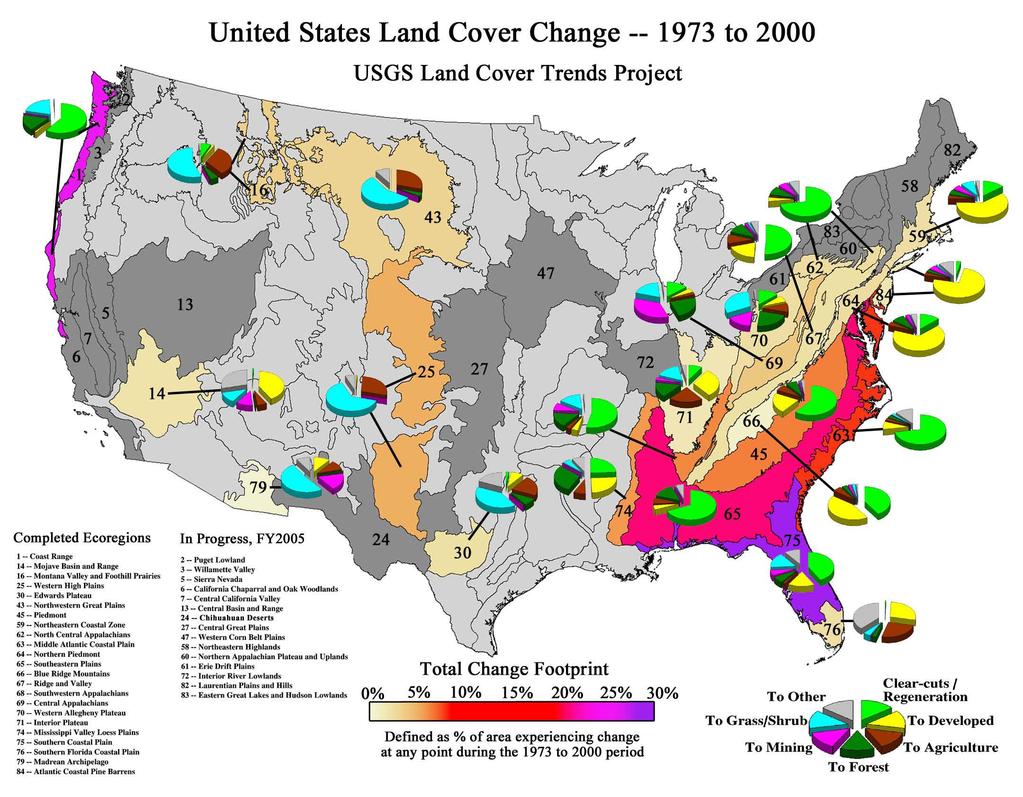
16
.")
17 Regional Carbon Trends Spatially-Explicit Biogeochemical Modeling The General Ensemble biogeochemical Modeling System (GEMS) was developed to simulate carbon dynamics within each of the sample blocks. It consists of Encapsulated ecosystem biogeochemical model (CENTURY). Data assimilation system Input/output processor User-friendly GUI Data Assimilation System Input Files Ecosystem Biogeochemical Model JFD Table Output Files JFD Cover Databases Soils Climate Land Use Info Units Overlay Operation Land Cover Time GIS Coverages Spatial and Temporal Changes of Land Cover, Carbon Stock in Vegetation and Soils
18 2004 Progress Organized Team: Apr and Oct 2004 Team Meetings Added CSU RAMS Modelers Sep 04 (Pielke, Hiemstra) Finalizing Reconstructed Eastern U.S. LCLU/Bioparam Data with Manuscript in Progress (Steyaert and Knox) Finalizing Land Cover Data for Western High Plains Initiated Analysis of Selected MODIS Land Products Developed and Tested Pro-type Land Use Model

19 Kuchler PNV as Proxy for Early 1600s: Remapped to VEMAP Vegetation Classes

20 USGS National Land Cover Dataset (NLCD) Derived from 1992/93 Landsat TM: Seamless 30-m Dataset with 21 Land Cover Classes for the Conterminous United States Vogelmann et al. (2001)
21 Reconstructed Land Cover History-Biophysical Parameter Dataset for the Eastern USA: Source: L. Steyaert and R. Knox (paper in preparation) Eastern Forest Region (Braun, 1950) For Water, Energy, and Carbon Studies (~10 km grid) Time Slices: early-1600s, 1850, 1920, 1992 Consistent LC and Biophysical Parameter Classes Used Kuchler PNV, Census, Ancillary, NLCD, other Products: Class Fractional Area Layers & Bio-params

22 MODIS Land Data Validation Sites with ASCII Subsets at ORNL DAAC for RAMS LSP Analysis

23 Eco-Region Analysis of MODIS Data: Albedo, VI, LAI
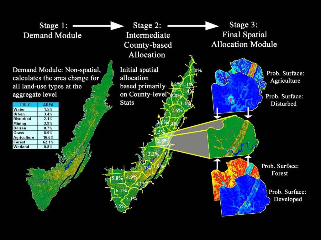
24 LULC Modeling Techniques Our Suggested technique Suggested technique is similar to the CLUE, CLUE-S, and derivative models as created by Verburg and Veldcamp, at Wageningen Agricultural University in the Netherlands Described by Briassoulis as an integrated, spatially explicit, multi-scale, dynamic, economy-environment-society-land use model CLUE attempts to account for the entire system of complex interactions between historic and present land use, socio-economic conditions, and biophysical constraints Fits well with scenario frameworks CLUE originally developed for national and continental level applications, CLUE-S adaptation for regional studies CLUE uses land use proportions by cell, while CLUE-S uses discrete land use values for each cell
25
26

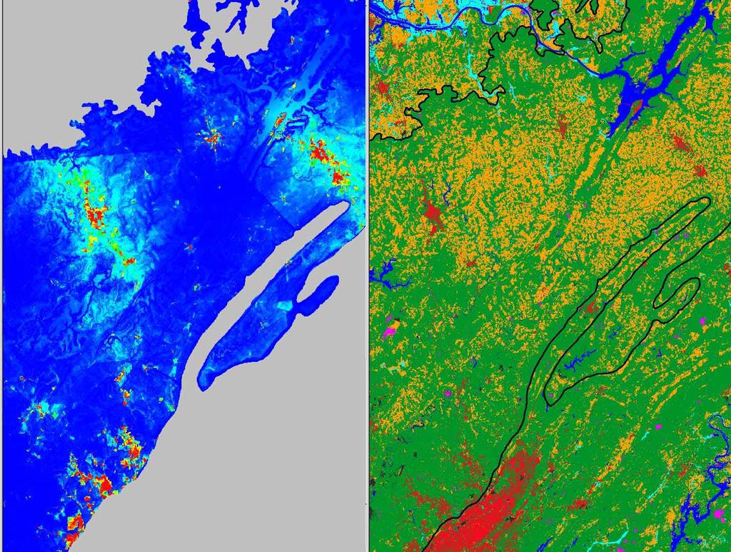
27 Developed -- Probability Surface
28
29 Plans for FY 2005 Tailor 1600s, 1920, and 1992 Land Datasets for RAMS Conduct LCLUC Simulations for Western High Plains (pre-settlement, 1920, 1992) including Sensitivity Tests with Heritage and MODIS LSP Test LU Forecast Model for Western High Plains and Conduct CSU RAMS Sensitivity Tests Conduct SE Plains Model Simulations Begin Model Validation and Assess Effects of LCLUC
NASA, EPA, USGS Partnership. U.S. Department of the Interior U.S. Geological Survey
 Spatial and Temporal Dimensions of Contemporary U.S. Land Cover/Land Use Change and Implications for Carbon Dynamics Tom Loveland and Shuguang Liu USGS EROS Data Center, Sioux Falls, SD NASA, EPA, USGS
53rd lntern.ational Astronautical Congress The,World Space Congress Ott 2002/Houston, Texas
 USING LANDSAT-DERIVED LAND COVER, RECONSTRUCTED VEGETATION, AND ATMOSPHERIC MESOSCALE MODELING IN ENVIRONMENTAL ANQ GLOBAL CHANGE RESEARCH L. Steyaert, Ph.D. U. S. Geological Survey NASA Goddard Space
U.S. Department of the Interior U.S. Geological Survey. Krista Karstensen Mark Drummond
 USGS Land-Cover Trends: A focus on contemporary land-use and land-cover change within the LCCs U.S. Department of the Interior U.S. Geological Survey Krista Karstensen Mark Drummond The Challenge Land
Influence of variations in low-level moisture and soil moisture on the organization of summer convective systems in the US Midwest
 Influence of variations in low-level moisture and soil moisture on the organization of summer convective systems in the US Midwest Jimmy O. Adegoke 1, Sajith Vezhapparambu 1, Christopher L. Castro 2, Roger
Utility of National Spatial Data for Conservation Design Projects
 Utility of National Spatial Data for Conservation Design Projects Steve Williams Biodiversity and Spatial Information Center North Carolina State University PIF CDW St. Louis, MO April 11, 2006 Types of
Use of climate reanalysis for EEA climate change assessment. Blaz Kurnik. European Environment Agency (EEA)
") Use of climate reanalysis for EEA climate change assessment Blaz Kurnik European Environment Agency (EEA) 2016: EEA content priorities Circular economy Climate and Energy Sustainable Development Goals
Use of climate reanalysis for EEA climate change assessment Blaz Kurnik European Environment Agency (EEA) 2016: EEA content priorities Circular economy Climate and Energy Sustainable Development Goals
Quenching the Valley s thirst: The connection between Sierra Nevada snowpack & regional water supply
 Quenching the Valley s thirst: The connection between Sierra Nevada snowpack & regional water supply Roger Bales, UC Merced Snow conditions Snow & climate change Research directions Sierra Nevada snow
Climate Impacts of Agriculture Related Land Use Change in the US
 Climate Impacts of Agriculture Related Land Use Change in the US Jimmy Adegoke 1, Roger Pielke Sr. 2, Andrew M. Carleton 3 1 Dept. Of Geosciences, University of Missouri-Kansas City 2 Dept. of Atmospheric
Near Real-Time Runoff Estimation Using Spatially Distributed Radar Rainfall Data. Jennifer Hadley 22 April 2003
 Near Real-Time Runoff Estimation Using Spatially Distributed Radar Rainfall Data Jennifer Hadley 22 April 2003 Introduction Water availability has become a major issue in Texas in the last several years,
Transboundary water management with Remote Sensing. Oluf Jessen DHI Head of Projects, Water Resources Technical overview
 Transboundary water management with Remote Sensing Oluf Jessen DHI Head of Projects, Water Resources Technical overview ozj@dhigroup.com Transboundary water management Water management across national
Dual-Frequency Ku- Band Radar Mission Concept for Snow Mass
 Dual-Frequency Ku- Band Radar Mission Concept for Snow Mass Chris Derksen Environment and Climate Change Canada Study Team: Climate Research Division/Meteorological Research Division, ECCC Canadian Space
DROUGHT ASSESSMENT USING SATELLITE DERIVED METEOROLOGICAL PARAMETERS AND NDVI IN POTOHAR REGION
 DROUGHT ASSESSMENT USING SATELLITE DERIVED METEOROLOGICAL PARAMETERS AND NDVI IN POTOHAR REGION Researcher: Saad-ul-Haque Supervisor: Dr. Badar Ghauri Department of RS & GISc Institute of Space Technology
NIDIS Remote Sensing Workshop: Showcase of Products & Technologies
 Feature Article From Intermountain West Climate Summary, April 2008 NIDIS Remote Sensing Workshop: Showcase of Products & Technologies By Christina Alvord of WWA Three knowledge assessment workshops are
Remote Sensing products and global datasets. Joint Research Centre, European Commission
 Remote Sensing products and global datasets Joint Research Centre, European Commission Setting the stage. Needs and requirements for integrated approach(es) for land degradation assessment. in Special
Hydrologic and Hydraulic Analyses Using ArcGIS
 Hydrologic and Hydraulic Analyses Using ArcGIS Two day training class Overview ArcGIS and Arc Hydro provide strong foundation for support of hydrologic and hydraulic (H&H) analyses. This two-day course
The National Integrated Drought Information System (NIDIS) Moving the Nation from Reactive to Proactive Drought Risk Management
 Moving the Nation from Reactive to Proactive Drought Risk Management") The National Integrated Drought Information System (NIDIS) Moving the Nation from Reactive to Proactive Drought Risk Management CSG-West Annual Meeting Agriculture & Water Committee Snowbird, UT September
The National Integrated Drought Information System (NIDIS) Moving the Nation from Reactive to Proactive Drought Risk Management CSG-West Annual Meeting Agriculture & Water Committee Snowbird, UT September
NASA NNG06GC42G A Global, 1-km Vegetation Modeling System for NEWS February 1, January 31, Final Report
 NASA NNG06GC42G A Global, 1-km Vegetation Modeling System for NEWS February 1, 2006- January 31, 2009 Final Report Scott Denning, Reto Stockli, Lixin Lu Department of Atmospheric Science, Colorado State
Analyzing and Visualizing Precipitation and Soil Moisture in ArcGIS
 Analyzing and Visualizing Precipitation and Soil Moisture in ArcGIS Wenli Yang, Pham Long, Peisheng Zhao, Steve Kempler, and Jennifer Wei * NASA Goddard Earth Science Data and Information Services Center
Implications of Climate Change on Long Lead Forecasting and Global Agriculture. Ray Motha
 Implications of Climate Change on Long Lead Forecasting and Global Agriculture Ray Motha Source: http://www.coaps.fsu.edu/lib/climatoons/toon38.shtml ENSO Teleconnections 30 Observed Monthly Sea Surface
Long-Term Patterns of Coastal Response to Changing Land Use and Climate: Examples from the Atlantic and Gulf Coastal Plains
 Long-Term Patterns of Coastal Response to Changing Land Use and Climate: Examples from the Atlantic and Gulf Coastal Plains Debra Willard, Christopher Bernhardt, and Miriam Jones U.S. Geological Survey,
Impact of vegetation cover estimates on regional climate forecasts
 Impact of vegetation cover estimates on regional climate forecasts Phillip Stauffer*, William Capehart*, Christopher Wright**, Geoffery Henebry** *Institute of Atmospheric Sciences, South Dakota School
Greening of Arctic: Knowledge and Uncertainties
 Greening of Arctic: Knowledge and Uncertainties Jiong Jia, Hesong Wang Chinese Academy of Science jiong@tea.ac.cn Howie Epstein Skip Walker Moscow, January 28, 2008 Global Warming and Its Impact IMPACTS
The Colorado Drought : 2003: A Growing Concern. Roger Pielke, Sr. Colorado Climate Center.
 The Colorado Drought 2001-2003: 2003: A Growing Concern Roger Pielke, Sr. Colorado Climate Center Prepared by Tara Green and Odie Bliss http://climate.atmos.colostate.edu 2 2002 Drought History in Colorado
Students: Michelle (Xue) Li (Michigan State U) Huiqing Huang (Michigan State U)
 Li (Michigan State U) Huiqing Huang (Michigan State U)") Researchers: Peilei Fan (Michigan State U) Joseph Messina (Michigan State U) Nathan Moore (Michigan State U) Jianjun Ge (Oklahoma State U) Peter Verburg, (VU University Amsterdam) Wenze Yue (MSU and Zhejiang
Researchers: Peilei Fan (Michigan State U) Joseph Messina (Michigan State U) Nathan Moore (Michigan State U) Jianjun Ge (Oklahoma State U) Peter Verburg, (VU University Amsterdam) Wenze Yue (MSU and Zhejiang
Regional climate modelling in the future. Ralf Döscher, SMHI, Sweden
 Regional climate modelling in the future Ralf Döscher, SMHI, Sweden The chain Global H E H E C ( m 3/s ) Regional downscaling 120 adam 3 C HAM 4 adam 3 C HAM 4 trl A2 A2 B2 B2 80 40 0 J F M A M J J A S
AGOG 485/585 /APLN 533 Spring Lecture 5: MODIS land cover product (MCD12Q1). Additional sources of MODIS data
. Additional sources of MODIS data") AGOG 485/585 /APLN 533 Spring 2019 Lecture 5: MODIS land cover product (MCD12Q1). Additional sources of MODIS data Outline Current status of land cover products Overview of the MCD12Q1 algorithm Mapping
AGOG 485/585 /APLN 533 Spring 2019 Lecture 5: MODIS land cover product (MCD12Q1). Additional sources of MODIS data Outline Current status of land cover products Overview of the MCD12Q1 algorithm Mapping
Understanding Weather and Climate Risk. Matthew Perry Sharing an Uncertain World Conference The Geological Society, 13 July 2017
 Understanding Weather and Climate Risk Matthew Perry Sharing an Uncertain World Conference The Geological Society, 13 July 2017 What is risk in a weather and climate context? Hazard: something with the
Data sources and classification for ecosystem accounting g
 Data sources and classification for ecosystem accounting Ken Bagstad 23 February 2015 Wealth Accounting and the Valuation of Ecosystem Services www.wavespartnership.org Data sources and classification
Christopher L. Castro Department of Atmospheric Sciences University of Arizona
 Spatiotemporal Variability and Covariability of Temperature, Precipitation, Soil Moisture, and Vegetation in North America for Regional Climate Model Applications Christopher L. Castro Department of Atmospheric
The U.S. National Integrated Drought Information System. Roger S. Pulwarty National Oceanic and Atmospheric Administration USA
 The U.S. National Integrated Drought Information System Roger S. Pulwarty National Oceanic and Atmospheric Administration USA Drought: Weather-climate continuum and adaptation deficits 2010 2011 2012 2015
ECCC/CCMEP variable resolution modelling of the Hudson Bay watershed
 ECCC/CCMEP variable resolution modelling of the Hudson Bay watershed Vincent Fortin (and many collaborators) Division de la recherche en météorologie Environnement en Changement climatique Canada GEM-based
Modeling the Effects of Climate and Land Cover Change in the Stoney Brook Subbasin of the St. Louis River Watershed
 Modeling the Effects of Climate and Land Cover Change in the Stoney Brook Subbasin of the St. Louis River Watershed Joe Johnson and Jesse Pruette 214 NASA Research Internship Geospatial Technologies Program
Global SoilMappingin a Changing World
 Global SoilMappingin a Changing World Sabine Grunwald Acknowledgements: GIS-Pedometrics Team, UF Soil Story My soil story. Your soil story Digital Soil Mapping in a Changing World Global climate change,
Role of GIS and Remote Sensing to Environment Statistics
 United Nations Economic Commission for Africa Role of GIS and Remote Sensing to Environment Dozie Ezigbalike Data Management Coordinator A Definition Environment statistics are statistics that describe
Copernicus Overview. Major Emergency Management Conference Athlone 2017
 Copernicus Overview Major Emergency Management Conference Athlone 2017 Copernicus is a European programme implemented by the European Commission. The services address six thematic areas: land, marine,
NSF Expeditions in Computing. Understanding Climate Change: A Data Driven Approach. Vipin Kumar University of Minnesota
 NSF Expeditions in Computing Understanding Climate Change: A Data Driven Approach Vipin Kumar University of Minnesota kumar@cs.umn.edu www.cs.umn.edu/~kumar Vipin Kumar UCC Aug 15, 2011 Climate Change:
UNSD SEEA-EEA revision 2020
 UNSD SEEA-EEA revision 2020 Area 1: Spatial units; introduction Sjoerd Schenau, Patrick Bogaart, Edwin Horlings London group meeting, October 2018 Overview Spatial units in SEEA EEA Main revision issues
Estimating the Spatial Distribution of Power Outages during Hurricanes for Risk Management
 Estimating the Spatial Distribution of Power Outages during Hurricanes for Risk Management Marco Palmeri Independent Consultant Master s Candidate, San Francisco State University Dept. of Geography September
SPATIAL AND TEMPORAL MODELLING OF ECOSYSTEM SERVICES
 SPATIAL AND TEMPORAL MODELLING OF ECOSYSTEM SERVICES Solen Le Clec h, T.Decaëns, S. Dufour, M. Grimaldi, N. Jégou and J. Oszwald ACES Conference 2016 Jacksonville, Florida (USA). December, 5-9th : issues
EnviroAtlas: An Atlas about Ecosystems and their Connection with People
 EnviroAtlas: An Atlas about Ecosystems and their Connection with People Annie Neale, Megan Mehaffey & Atlas Team ASWM Webinar October, 17 th, 2012 What is it? The Atlas is an online decision support tool
Creating a WeatherSMART nation: SAWS drought related research, services and products
 Creating a WeatherSMART nation: SAWS drought related research, services and products Drought Dialogue 23-24 June 2016 Western Cape Government Hannes Rautenbach South African Weather Service SAWS mandate
Overview on Land Cover and Land Use Monitoring in Russia
 Russian Academy of Sciences Space Research Institute Overview on Land Cover and Land Use Monitoring in Russia Sergey Bartalev Joint NASA LCLUC Science Team Meeting and GOFC-GOLD/NERIN, NEESPI Workshop
Susquehanna River Basin A Research Community Hydrologic Observatory. NSF-Funded Infrastructure Proposal in Support of River Basin Hydrologic Sciences
 Susquehanna River Basin A Research Community Hydrologic Observatory NSF-Funded Infrastructure Proposal in Support of River Basin Hydrologic Sciences Fundamental Problem: How Do Humans and Climate Impact
Land Accounts - The Canadian Experience
 Land Accounts - The Canadian Experience Development of a Geospatial database to measure the effect of human activity on the environment Who is doing Land Accounts Statistics Canada (national) Component
Enhancement of the U.S. Drought Monitor Through the Integration of NASA Vegetation Index Imagery
 Enhancement of the U.S. Drought Monitor Through the Integration of NASA Vegetation Index Imagery Project and Related Activities at USGS/EROS Jim Verdin, Jesslyn Brown, Yingxin Gu, Gail Schmidt, Troy McVay
Harrison 1. Identifying Wetlands by GIS Software Submitted July 30, ,470 words By Catherine Harrison University of Virginia
 Harrison 1 Identifying Wetlands by GIS Software Submitted July 30, 2015 4,470 words By Catherine Harrison University of Virginia cch2fy@virginia.edu Harrison 2 ABSTRACT The Virginia Department of Transportation
Geography General Course Year 12. Selected Unit 3 syllabus content for the. Externally set task 2019
 Geography General Course Year 12 Selected Unit 3 syllabus content for the Externally set task 2019 This document is an extract from the Geography General Course Year 12 syllabus, featuring all of the content
The Colorado Drought of 2002 in Perspective
 The Colorado Drought of 2002 in Perspective Colorado Climate Center Nolan Doesken and Roger Pielke, Sr. Prepared by Tara Green and Odie Bliss http://climate.atmos.colostate.edu Known Characteristics of
Global Climate Change and the Implications for Oklahoma. Gary McManus Associate State Climatologist Oklahoma Climatological Survey
 Global Climate Change and the Implications for Oklahoma Gary McManus Associate State Climatologist Oklahoma Climatological Survey OCS LEGISLATIVE MANDATES Conduct and report on studies of climate and weather
Tracking the Climate Of Northern Colorado Nolan Doesken State Climatologist Colorado Climate Center Colorado State University
 Tracking the Climate Of Northern Colorado Nolan Doesken State Climatologist Colorado Climate Center Colorado State University Northern Colorado Business Innovations November 20, 2013 Loveland, Colorado
Climate also has a large influence on how local ecosystems have evolved and how we interact with them.
 The Mississippi River in a Changing Climate By Paul Lehman, P.Eng., General Manager Mississippi Valley Conservation (This article originally appeared in the Mississippi Lakes Association s 212 Mississippi
Dust prediction models
 Dust prediction models Sara Basart 1 (sara.basart@bsc.es), E. Terradellas 2, E. Cuevas 3, O. Jorba 1, J.M. Baldasano 1 and F. Benincasa 1 1 Earth Sciences Department, BSC, Barcelona, Spain 2 AEMET, Barcelona,
Development of IDL-based geospatial data processing framework for meteorology and air quality modeling
 Development of IDL-based geospatial data processing framework for meteorology and air quality modeling Hyun Cheol Kim 1,2,3, Fong Ngan 1,2,4, Pius Lee 2,3, and Daniel Tong 1,2,5 1 Cooperative Institute
Behind the Climate Prediction Center s Extended and Long Range Outlooks Mike Halpert, Deputy Director Climate Prediction Center / NCEP
 Behind the Climate Prediction Center s Extended and Long Range Outlooks Mike Halpert, Deputy Director Climate Prediction Center / NCEP September 2012 Outline Mission Extended Range Outlooks (6-10/8-14)
Jim Fox. copyright UNC Asheville's NEMAC
 Decisions and System Thinking Jim Fox November, 2012 1 UNC Asheville s s NEMAC National Environmental Modeling and Analysis Center Applied Research and technology development on integration of environmental
Analysis of Historical Pattern of Rainfall in the Western Region of Bangladesh
 24 25 April 214, Asian University for Women, Bangladesh Analysis of Historical Pattern of Rainfall in the Western Region of Bangladesh Md. Tanvir Alam 1*, Tanni Sarker 2 1,2 Department of Civil Engineering,
2002 Drought History in Colorado A Brief Summary
 1 2002 Drought History in Colorado A Brief Summary Colorado Climate Center Roger Pielke, Sr, Director and Nolan Doesken, Research Associate Prepared by Odie Bliss & Tara Green http://climate.atmos.colostate.edu
WATER RESOURCES RESEARCH, VOL. 44, W11401, doi: /2007wr006546, 2008
 WATER RESOURCES RESEARCH, VOL. 44,, doi:10.1029/2007wr006546, 2008 Sensitivity of June near-surface temperatures and precipitation in the eastern United States to historical land cover changes since European
Satellite data for hydrological forecasting
 Satellite data for hydrological forecasting Current use at ECMWF and perspective Shopping list! Our current tools does not allow direct use, but could be modified Christel Prudhomme Christel.prudhomme@ecmwf.int
 Page 1 of 15 The first interesting thing about talking with Roger Pielke on the subject of land cover and climate change is that he simultaneously gives the impression that everything he is saying, he
Regional Drought Decision Support System (RDDSS) Project Update and Product Concepts
 Project Update and Product Concepts") Regional Drought Decision Support System (RDDSS) Project Update and Product Concepts Part of the Red River Basin Decision Information Network (RRBDIN) NEXT-GEN RRBDIN Decision Support for the Red River
Regional Drought Decision Support System (RDDSS) Project Update and Product Concepts Part of the Red River Basin Decision Information Network (RRBDIN) NEXT-GEN RRBDIN Decision Support for the Red River
A SURVEY OF HYDROCLIMATE, FLOODING, AND RUNOFF IN THE RED RIVER BASIN PRIOR TO 1870
 A SURVEY OF HYDROCLIMATE, FLOODING, AND RUNOFF IN THE RED RIVER BASIN PRIOR TO 1870 W. F. RANNIE (UNIVERSITY OF WINNIPEG) Prepared for the Geological Survey of Canada September, 1998 TABLE OF CONTENTS
Characteristics of a NIDIS Pilot Project Colorado Basin
 Characteristics of a NIDIS Pilot Project Colorado Basin NIDIS Implementation Meeting Longmont, Colorado September 21-22, 2006 Dave Brandon Manager/Director Hydrology & Climate Services Division NOAA- Western
Permanent Ice and Snow
 Soil Moisture Active Passive (SMAP) Ancillary Data Report Permanent Ice and Snow Preliminary, v.1 SMAP Science Document no. 048 Kyle McDonald, E. Podest, E. Njoku Jet Propulsion Laboratory California Institute
Understanding the hydrology of the large wetlands of the Bolivian Amazon using remote sensing and hydrological modeling
 Understanding the hydrology of the large wetlands of the Bolivian Amazon using remote sensing and hydrological modeling Preliminary results 6 th SO HYBAM Scientific Meeting Cusco, Octubre 2015 Alex Ovando
Canadian Prairie Snow Cover Variability
 Canadian Prairie Snow Cover Variability Chris Derksen, Ross Brown, Murray MacKay, Anne Walker Climate Research Division Environment Canada Ongoing Activities: Snow Cover Variability and Links to Atmospheric
Top Ten Overlooked Issues in Climate Change Science
 Top Ten Overlooked Issues in Climate Change Science Roger A. Pielke Sr. Colorado State University Department of Atmospheric Science Fort Collins, Colorado Policy Statement on Climate Variability and Change
Soil Moisture Prediction and Assimilation
 Soil Moisture Prediction and Assimilation Analysis and Prediction in Agricultural Landscapes Saskatoon, June 19-20, 2007 STEPHANE BELAIR Meteorological Research Division Prediction and Assimilation Atmospheric
LCMAP Workshop Welcome. Jesslyn F. Brown USGS/EROS Nov 6, 2018
 LCMAP Workshop Welcome Jesslyn F. Brown USGS/EROS Nov 6, 2018 LCMAP: Workshop Goals Land Change Monitoring, Analysis, and Projection (LCMAP) Provide an update on current status (Version 1) Algorithm approaches
GEO-IV. Weather, Climate and Earth System Prediction. Document November This document is submitted to GEO-IV for information.
 GEO-IV 28-29 November 2007 Weather, Climate and Earth System Prediction Document 22 This document is submitted to GEO-IV for information. The Socioeconomic and Environmental Benefits of a Revolution in
Highlights of the 2006 Water Year in Colorado
 Highlights of the 2006 Water Year in Colorado Nolan Doesken, State Climatologist Atmospheric Science Department Colorado State University http://ccc.atmos.colostate.edu Presented to 61 st Annual Meeting
Preparation of LULC map from GE images for GIS based Urban Hydrological Modeling
 International Conference on Modeling Tools for Sustainable Water Resources Management Department of Civil Engineering, Indian Institute of Technology Hyderabad: 28-29 December 2014 Abstract Preparation
The ENSEMBLES Project
 The ENSEMBLES Project Providing ensemble-based predictions of climate changes and their impacts by Dr. Chris Hewitt Abstract The main objective of the ENSEMBLES project is to provide probabilistic estimates
Developing EU-BON's site-specific portal
 General meeting- Cambridge, 2-4 June, 2015 Developing EU-BON's site-specific portal Yoni Gavish University of Leeds gavishyoni@gmail.com 1 Before we start... I have no expertise in data management + web
Land abandonment and recultivation in Central and Eastern Europe
 Land abandonment and recultivation in Central and Eastern Europe Patrick Hostert Patrick Griffiths, Stephan Estel, Camilo Alcantara, Tobias Kuemmerle, Dirk Pflugmacher, Alexander Prishchepov, Volker Radeloff
USGS ATLAS. BACKGROUND
 USGS ATLAS. BACKGROUND 1998. Asquith. DEPTH-DURATION FREQUENCY OF PRECIPITATION FOR TEXAS. USGS Water-Resources Investigations Report 98 4044. Defines the depth-duration frequency (DDF) of rainfall annual
Comparing the Land Use and Land Cover Changes Between the North and South Louisiana Using Data Mining
 Comparing the Land Use and Land Cover Changes Between the North and South Louisiana Using Data Mining Yi Qiang and Nina Lam Department of Environmental Sciences Louisiana State University yqiang1@lsu.edu,
An Overview On the Complexity of the Climate System and the Role of Humans Within It
 An Overview On the Complexity of the Climate System and the Role of Humans Within It Roger A. Pielke Sr. University of Colorado, CIRES, Boulder, CO Lecture Presented to University of Colorado Class ATOC4800/5000
Future Climate Change
 Future Climate Change How do you know whether to trust a prediction about the future? All predictions are based on global circulation models (GCMs, AOGCMs) - model accuracy is verified by its ability to
The North American Drought Monitor - The Canadian Perspective -
 The North American Drought Monitor - The Canadian Perspective - Trevor Hadwen National Agroclimate Information Service AAFC-PFRA, Regina Canmore, Alberta March 16-18, 2008 Background The NADM is a cooperative
Development of the Canadian Precipitation Analysis (CaPA) and the Canadian Land Data Assimilation System (CaLDAS)
 and the Canadian Land Data Assimilation System (CaLDAS)") Development of the Canadian Precipitation Analysis (CaPA) and the Canadian Land Data Assimilation System (CaLDAS) Marco L. Carrera, Vincent Fortin and Stéphane Bélair Meteorological Research Division Environment
Development of the Canadian Precipitation Analysis (CaPA) and the Canadian Land Data Assimilation System (CaLDAS) Marco L. Carrera, Vincent Fortin and Stéphane Bélair Meteorological Research Division Environment
Activities of NOAA s NWS Climate Prediction Center (CPC)
") Activities of NOAA s NWS Climate Prediction Center (CPC) Jon Gottschalck and Dave DeWitt Improving Sub-Seasonal and Seasonal Precipitation Forecasting for Drought Preparedness May 27-29, 2015 San Diego,
Activities of NOAA s NWS Climate Prediction Center (CPC) Jon Gottschalck and Dave DeWitt Improving Sub-Seasonal and Seasonal Precipitation Forecasting for Drought Preparedness May 27-29, 2015 San Diego,
Interaction of North American Land Data Assimilation System and National Soil Moisture Network: Soil Products and Beyond
 Interaction of North American Land Data Assimilation System and National Soil Moisture Network: Soil Products and Beyond Youlong Xia 1,2, Michael B. Ek 1, Yihua Wu 1,2, Christa Peters-Lidard 3, David M.
USGS Water Census Guidelines and Specifications for ET Remote Sensing
 USGS Water Census Guidelines and Specifications for ET Remote Sensing U.S. Department of the Interior U.S. Geological Survey Guidelines and specifications Many prior and ongoing crop ET remote sensing
Climate Change Models: The Cyprus Case
 Climate Change Models: The Cyprus Case M. Petrakis, C. Giannakopoulos, G. Lemesios National Observatory of Athens AdaptToClimate 2014, Nicosia Cyprus Climate Research (1) Climate is one of the most challenging
Funding provided by NOAA Sectoral Applications Research Project CLIMATE. Basic Climatology Colorado Climate Center
 Funding provided by NOAA Sectoral Applications Research Project CLIMATE Basic Climatology Colorado Climate Center Remember These? Factor 1: Our Energy Source Factor 2: Revolution & Tilt Factor 3: Rotation!
Drought in Southeast Colorado
 Drought in Southeast Colorado Nolan Doesken and Roger Pielke, Sr. Colorado Climate Center Prepared by Tara Green and Odie Bliss http://climate.atmos.colostate.edu 1 Historical Perspective on Drought Tourism
Water & Climate; Floods & Droughts (The yin & yang of water availablilty) Water & Climate; Floods & Droughts (The yin & yang of water availablilty)
 Water & Climate; Floods & Droughts (The yin & yang of water availablilty)") (Acknowledgment: This presentation was developed in collaboration with ESA, NEON and NCEAS, federal agencies and academic team members from minority serving institutions.) Water & Climate; Floods & Droughts
(Acknowledgment: This presentation was developed in collaboration with ESA, NEON and NCEAS, federal agencies and academic team members from minority serving institutions.) Water & Climate; Floods & Droughts
GIS in Weather and Society
 GIS in Weather and Society Olga Wilhelmi Institute for the Study of Society and Environment National Center for Atmospheric Research WAS*IS November 8, 2005 Boulder, Colorado Presentation Outline GIS basic
Millennium Ecosystem Assessment
 Millennium Ecosystem Assessment Global Data Challenges from an MA perspective Global Spatial Data and Information User Workshop 21-23 September 2004! What is the MA?! How and what kinds of data does it
Diagnosing the Climatology and Interannual Variability of North American Summer Climate with the Regional Atmospheric Modeling System (RAMS)
") Diagnosing the Climatology and Interannual Variability of North American Summer Climate with the Regional Atmospheric Modeling System (RAMS) Christopher L. Castro and Roger A. Pielke, Sr. Department of
Diagnosing the Climatology and Interannual Variability of North American Summer Climate with the Regional Atmospheric Modeling System (RAMS) Christopher L. Castro and Roger A. Pielke, Sr. Department of
Arctic-Coastal Land Ocean Interactions
 Arctic- Project PIs: Maria Tzortziou (CCNY / CUNY) Antonio Mannino (NASA/GSFC) Joseph Salisbury (Univ. of NH) Peter Hernes (UC Davis) Carlos Del Castillo (NASA/GSFC) Marjorie Friedrichs (VIMS) Patricia
Challenges for Climate Science in the Arctic. Ralf Döscher Rossby Centre, SMHI, Sweden
 Challenges for Climate Science in the Arctic Ralf Döscher Rossby Centre, SMHI, Sweden The Arctic is changing 1) Why is Arctic sea ice disappearing so rapidly? 2) What are the local and remote consequences?
Why Hydrological Services are Important to Business
 Why Hydrological Services are Important to Business Dr. David Green Program Manager, Disasters Earth Science Division David.s.green@nasa.gov May 8, 2018 2 Communities and Areas of Intensive Risk Socio-Economic
Validation of satellite derived snow cover data records with surface networks and m ulti-dataset inter-comparisons
 Validation of satellite derived snow cover data records with surface networks and m ulti-dataset inter-comparisons Chris Derksen Climate Research Division Environment Canada Thanks to our data providers:
The Canadian Land Data Assimilation System (CaLDAS)
") The Canadian Land Data Assimilation System (CaLDAS) Marco L. Carrera, Stéphane Bélair, Bernard Bilodeau and Sheena Solomon Meteorological Research Division, Environment Canada Dorval, QC, Canada 2 nd Workshop
The Canadian Land Data Assimilation System (CaLDAS) Marco L. Carrera, Stéphane Bélair, Bernard Bilodeau and Sheena Solomon Meteorological Research Division, Environment Canada Dorval, QC, Canada 2 nd Workshop
United States Multi-Hazard Early Warning System
 United States Multi-Hazard Early Warning System Saving Lives Through Partnership Lynn Maximuk National Weather Service Director, Central Region Kansas City, Missouri America s s Weather Enterprise: Protecting
CLIMATE CHANGE DATA PROJECTIONS FOR ONTARIO AND THE GREAT LAKES BASIN
 CLIMATE CHANGE DATA PROJECTIONS FOR ONTARIO AND THE GREAT LAKES BASIN ECO Climate Data Roundtable, January 8, 2014 Richard Peltier, Physics, U Toronto Regional Data Sets of Climate Change Projections 2
2003 Moisture Outlook
 2003 Moisture Outlook Nolan Doesken and Roger Pielke, Sr. Colorado Climate Center Prepared by Tara Green and Odie Bliss http://climate.atmos.colostate.edu Through 1999 Through 1999 Fort Collins Total Water
Orchestrating a Climate Modeling Pipeline. using Python and RAM Disk
 Introduction The Pipeline PyWPS Conclusion Orchestrating a Climate Modeling Data Pipeline using Python and RAM Disk A Brief Overview of the WRF Tools Package Andre R. Erler PyCon Canada November 7 th,